Abstract
The increase in demand for mineral resources, the depletion of the resources (deposits) and numerous environmental and social limitations concerning their utilization led to research on the assessment of environmental and the social availability of compact raw material deposits classified as key raw materials. The methodology of the research is based on the proposed environmental and social assessment procedure for the availability of deposits, in which, based on the constraints resulting from legal, environmental and planning conditions, four deposit availability classes have been determined: class I—very well accessible deposit, class II—well accessible deposit, class III—accessible deposit and class IV—inaccessible deposit. Ultimately, seven variables influencing the availability of the deposit were selected for the assessment, i.e., forms of nature protection, forests with protective functions, zones of indirect protection of groundwater and surface water intakes, main groundwater reservoirs, surface water reservoirs, rivers, streams and canals, buildings and infrastructure and road and railway. The research was carried out for 244 deposits located in Poland (Central Europe) with total resources of over 7.6 billion tons. The availability of deposits was analyzed for two variants. The first one included all the variables. The second variant, on the other hand, excluded railway infrastructure due to the fact that 90% of the compact raw materials transport is carried out by trucks. Finally, in variant I of the assessment, three classes of deposit availability were obtained: class IV inaccessible deposits (146 deposits), class III available deposits (93 deposits), and class II well-accessible deposits (5 deposits). In variant II four classes of deposit availability were obtained: class IV inaccessible deposits (145 deposits), class III available deposits (68 deposits), class II well-accessible deposits (28 deposits) and class I deposits very easily accessible (3 deposits).
1. Introduction
Societies are constantly making efforts towards making the most effective use of their social and economic development. Improving the quality of life largely depends on mineral resources, as it involves, e.g., urbanization, the development of road and sewage systems, etc. Therefore, there is a continuous increase in demand for mineral resources, which increases the exploitation of these resources and the necessity to develop further mineral deposits [1]. However, the process of extending various forms of protection on the areas with documented mineral deposits limits their management potential [2,3,4,5,6]. Therefore, being aware of the depletion of deposits in areas not covered by environmental protection, causes mining companies to begin to pay attention to resources located in legally protected areas. In addition, the mining of raw materials must be an action accepted by the public [7,8,9,10,11]. The most important aspects to be taken into consideration when requesting such acceptance are the dust and noise caused by the mining plant. For this reason, a compromise is needed to ensure that the economic goals of the industry, the environment protection, and the social acceptance are complementary and not contradictory.
Reaching an agreement is very difficult, and therefore it seems necessary that performed research focuses on assessing the environmental and social accessibility of deposits, which is the aim of this publication. The research aim required in the first place is an analysis which would allow identifying rock raw materials important for the national economy. The analysis demonstrated that the focus should be placed on the so-called key raw materials. These include raw materials of fundamental importance for the proper functioning of the economy and for satisfying the living needs of people. They are thus raw materials which are scarce, but which offer a sustainable supply and a large domestic resource base, and which are the basic resources needed in the industry [12,13]. The next stages of research were to analyze the accessibility of documented rock raw material deposits located in legally protected areas of Poland, and to evaluate social and spatial planning conditions, such as road and rail accessibility and distance from housing developments, as investigated in this publication.
2. Materials and Methods
The environmental and social accessibility of key deposits was assessed on the basis of the proposed methodology proposed, which included four stages (Figure 1):
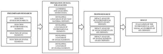
Figure 1.
Methodology for assessing the environmental and social accessibility of key deposits.
- (1)
- preliminary research,
- (2)
- preparation of data for analysis,
- (3)
- proper research (impact analysis of selected factors),
- (4)
- formulation of final evaluation.
2.1. Preliminary Research
A preliminary research consisting in: the selection of research objects (undeveloped deposits of non-metallic raw materials); identification of environmental, social and geographical elements, construction of a database including information on the deposits and on the above-listed elements and proper research consisting in the analysis of the impact of environmental, social and geographical elements on the accessibility of undeveloped key deposits.
The objects were selected in the first step of the preliminary research. This was performed for deposits of non-metallic raw materials explored in detail, i.e., deposits of dolomites, dimension and crushed stones, magnesites, feldspar raw materials and carbonate raw materials for the cement and lime industry to be found in Poland. The data on the deposits were obtained from Polish Geological Institute—National Research Institute [14,15]. Various deposits (244 in total) of compact raw materials with the total resources being over 7.6 billion tons were selected for the study. These were deposits of dolomites (3 deposits with the total resources of over 20 million tons), road and building stones (175 deposits, over 2 billion tons), vein quartzes (2 deposits, 281 thousand tons), quartzites (5 deposits, over 5 million tons), limestones and marls for the cement industry (28 deposits, 3.8 billion tons) and limestones and marls for the limestone industry (31, 1.2 billion tons) geographically located in the following voivodships: Dolnośląskie, Lubelskie, Łódzkie, Małopolskie, Mazowieckie, Opolskie, Podkarpackie, Śląskie, Świętokrzyskie and Zachodniopomorskie (Figure 2).
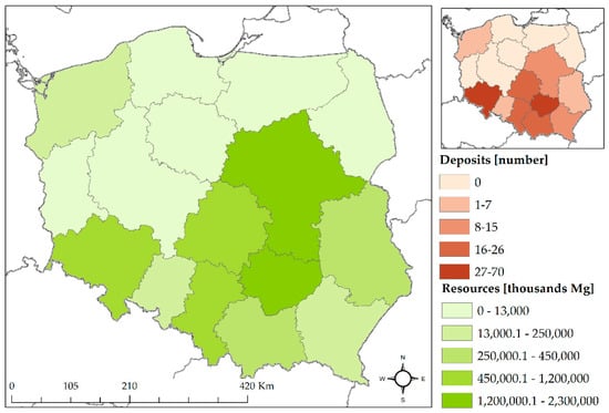
Figure 2.
Locations of key raw material deposits in Poland, along with the spatial distribution of the deposits and the quantities of the resources (own study based on [14,15]).
In the second step of the preliminary research, environmental and social elements were selected for research. By environmental variables, the authors understand all forms of environmental protection: national parks, nature reserves, nature monuments, landscape parks, the Natura 2000 areas, nature parks (protected landscape areas), landscape-nature complexes, ecological areas and documentation sites, forests with protective functions, indirect protection zones for groundwater and surface water intakes, major groundwater reservoirs, surface water reservoirs, rivers, streams and canals. Social variables, on the other hand, relate to objects, infrastructure or other elements of the environment directly related to the life of local residents and affecting the quality and comfort of their lives. They include criteria such as the distance from the deposit to the housing developments or transport-related accessibility. Additionally, a research method of examining documents was used to assess natural availability, which consists of collecting and analyzing the facts contained in it. The research was limited to the legal acts related to the establishment of individual forms of nature protection.
2.2. Preparation of Data for Analysis
For the second stage of the research, databases on environmental and social factors were prepared with the use of Geographic Information Systems (GIS). For this purpose, data were obtained from state institutions that collect environmental and social data. After their collection, the usefulness of the data for research was verified. Databases of environmental and social elements were developed for selected data (Figure 3).
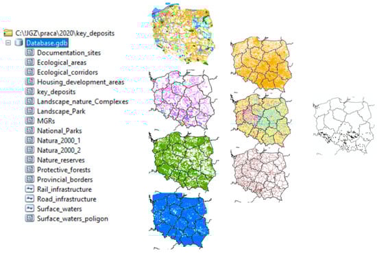
Figure 3.
Database of environmental and social elements.
2.3. Proper Research (Impact Analysis of Selected Factors)
In this research, the accessibility of key deposits was described as a function of many variables having an implicit and unknown form and grouped into three variables, i.e., environmental, social and spatial variables:
where
S = f(x1, x2, …, xi),
S = f (p, v, s),
- p—environmental variables,
- v—spatial variables,
- s—social variables.
As function f describing relationship between variables and results S is, in general, unknown, the evaluation is completed in an indirect way.
The above variables occur as both qualitative and quantitative variables, which were converted into numerical variables for the purpose of these analyses. The numerical value for the i-th variable describing the accessibility of the deposit was calculated on the basis of the accessibility key presented in Table 1.

Table 1.
Deposit accessibility scale.
Based on the legal, environmental and planning analysis for environmental and social elements, the deposit availability classes were determined according to the key from Table 1. The deposit availability classes for the environmental and social elements along with the conversion of descriptive variables into numerical variables are presented in Table 2.
Table 2.
Description of the deposit availability classes for environmental and social elements.
Then, an evaluation matrix was developed for the analyzed deposits, in which the evaluations obtained for the environmental and social variables included in the research were entered (Table 3). The final deposit assessment was performed according to the rule described below, i.e., first for deposits where the variable 0 occurred at least once, the deposit availability class IV was assigned, then for other deposits where the variable 1 occurred at least once, the deposit availability class III was assigned, for the other deposits where at least once it occurred variable 3 was assigned the deposit availability class II and for the remaining deposits the deposit availability class I, as follows:
Table 3.
Fragment of the matrix for assessing the availability of key deposits.
Algorithm for Accessibility Evaluation
- IF (OR(P1=0;P2=0;P3=0;P4=0;P5=0;P6=0;P7=0); “Class IV”;
- IF (OR(P1=1;P2=1;P3=1;P4=1;P5=1;P6=1;P7=1); “Class III”;
- IF(OR(P1=2;P2=2;P3=2;P4=2;P5=2;P6=2;P7=2); “Class II”;
- IF(OR(P1=3;P2=3;P3=3;P4=3;P5=3;P6=3;P7=3); “Class I”; “ ”))))
3. Results
3.1. Environmental Analysis
The limited accessibility of key raw materials and the depletion of the currently exploited deposits cause the attention to be drawn to resources in areas under various forms of protection: environment-, water- or forest-related. Therefore, it seems important to analyze the environmental accessibility of the analyzed deposits, which concerns four assumed aspects: forms of environmental protection, especially protected forests and surface waters, as well as main underground water reservoirs together with indirect protection zones for groundwater intakes. Environmental protection is significant for the maintenance and stability of ecosystems and ecological processes. The regulations regarding protected forests are of particular importance due to the fact that almost half of the forest-covered areas in Poland are protective forests which have primarily ecological and social functions [16]. Waters, on the other hand, prove vital for both residents and basic branches of economy. However, members of society should not forget that changing the location of a given mineral resource is not possible and if they want to maximize the benefits from the progress of civilization (based on mineral resources), a compromise must be found. Such a compromise may include an analysis of the accessibility of key raw material deposits performed among others from the environmental perspective.
3.1.1. Forms of Environment Protection
Areas of environmental value, often covered by one or more forms of protection, as specified in The Nature Conservation Act of 16 April 2004 [17], are locations to 63% of documented and unexploited rock deposits. The analyzed deposits are located in nature protected areas in nine voivodships (Figure 4 and Figure 5). The total resources in these areas are 4630.2 million tons, and are documented in 157 deposits.
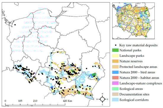
Figure 4.
Locations of the analyzed deposits in nature protected areas (own study based on [18]).
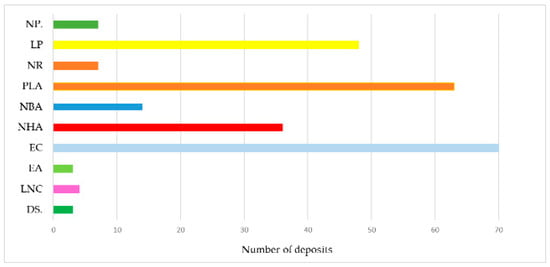
Figure 5.
Number of deposits located in individual nature protected areas.
Extraction of minerals must be performed in accordance with the provisions of The Geological and Mining Act of 9 June 2011 [19], i.e., after obtaining a concession which allows mining operations in a certain area. However, in accordance with Art. 72 of the Act on provision of information on the environment… [20], prior to obtaining a concession to extract a mineral from a deposit, an entrepreneur must obtain a decision on environmental conditions, which is then attached to the concession application. The most important stage in obtaining such a decision is to perform an assessment of the environmental impact in accordance with Art. 59 of the Act on provision of information on the environment… [20]. Such an assessment is required in the case of planned projects if:
- the project may continuously significantly impact the environment (operations which may continuously significantly impact the environment include inter alia mining of minerals from the deposit with the use of surface mining methods on a mining area not smaller than 25 ha and installations for the processing of minerals located at the premises of surface mines or quarries having an area not smaller than 25 ha [21]),
- the project may potentially significantly impact the environment (operations which may potentially significantly impact the environment include inter alia mining of minerals from the deposit with the use of surface mining methods on a mining area smaller than 25 ha, but larger than 2 ha, or in the case of extracted volume greater than 20,000 m3, installations for the processing of minerals located at the premises of surface mines or quarries having an area smaller than 25 ha, or located in areas under environmental protection [21]),
- the project may significantly impact the Natura 2000 area while not being directly related to the protection of the area or not being the result of such a protection,
- the obligation to perform an assessment of how the project impacts the Natura 2000 area was imposed by the decision of the Regional Director for Environmental Protection.
Considering the resources, the documented area and the location of the analyzed deposits in legally protected areas, such projects will be certainly qualified for the environmental impact assessment and will have to be preceded by an assessment of their impact on the protection objectives of a particular site.
An additional issue is related to the restrictions on the exploitation of minerals in legally protected areas, which can be interpreted from the Nature Conservation Act of 16 April 2004 [17]. An obligatory prohibition on mineral exploitation applies to areas of national parks (including buffer zones) and nature reserves. An additional issue is related to the restrictions on the exploitation of minerals in legally protected areas, which can be interpreted from the Nature Conservation Act of 16 April 2004 [17]. As a result, extraction of minerals from 11 documented deposits will not be possible in these areas (Table 4).
Table 4.
Most important environmentally protected areas being the locations of the analyzed deposits.
As the remaining analyzed deposits are located in legally protected areas, such as landscape parks, protected landscape areas, the Natura 2000 areas, landscape-nature complexes, ecological corridors and ecological areas, the possibilities for mineral extraction will be considered only within the borders of these areas. In the case of a landscape park (further: LP), its buffer zone and the protected zone, as well as in the case of a protected landscape area (further: PLA), the Act provides for the possibility of imposing a ban on the extraction of rocks for economic purposes (including peat, as well as minerals and amber) and on the implementation of projects which may significantly affect the environment within the meaning of the provisions of the Act on the provision of information on the environment and its protection, public participation in environmental protection and on environmental impact assessment [20]. Thus, the optional nature of the above-mentioned prohibitions indicates that they may (but do not have to) be included in the text of the legal act enacting a specific landscape park. They become obligatory at the instance of providing such entry in the act establishing the park. In the case of investments within the areas of a landscape park and a protected landscape area, derogation from the ban on the implementation of the projects in question may apply to projects for which the environmental impact assessment procedure has shown no adverse impact of the planned investment on nature and landscape.
The analysis of the provisions of the resolutions and ordinances which concern the landscape parks being locations for the documented deposits showed that in the case of 15 deposits located in the areas of 11 landscape parks, a complete ban is imposed on obtaining rocks for economic purposes in the areas of these parks (Table 5). Mining is also completely banned in the Tenczynek landscape park, except for one limestone deposit named “Płaza Południe”. However, in the case of five deposits, a ban on projects that may have a significant impact on the environment does not apply to the implementation of projects for which the environmental impact procedure may show no adverse impact on the nature and landscape of the park. In the case of seven deposits located in the areas of three parks: The Czarnorzecko–Strzyżowski LP, the Przemyskie Foothills LP and the Solska Forest LP, the extraction of minerals is possible under certain conditions—the exploitation area must not exceed 2 ha, the extraction should be greater than 20,000 m3 and should be performed without the use of blasting techniques. Prohibitions regarding the implementation of projects that may have a significant impact on the environment are also included in the provisions concerning the Śnieżnik Landscape Park and the Sudety Wałbrzyskie Landscape Park (4 documented deposits), but they do not apply to projects involving the extraction of rocks and minerals on an area smaller than 25 ha and, of course, if the environmental impact assessment procedure shows no adverse impact on the nature of the park.
Table 5.
Number of deposits located within the areas of landscape parks.
As regards Protected Landscape Areas, the analysis demonstrated that mineral extraction is completely prohibited in the case of eight deposits located in eight areas (Table 6). A complete ban on mineral extraction is imposed in the case of one deposit located in the PLA, as it is also the area of the Babia Góra National Park. Nevertheless, in the case of 43 deposits, the exploitation of raw materials is possible if the environmental impact assessment procedure shows no negative impact on the nature of the PLA. In the case of one PLA, the Otmuchów–Nysa Protected Landscape Area, exploitation is possible for deposits documented before 27 September 2016 (the deposit located in this area was documented in 2012). For the remaining 11 deposits, exploitation is possible, but under certain conditions:
Table 6.
Number of deposits located within the protected landscape area.
- if the deposit areas are introduced to the local development plan (LSDP) and both the strategic environmental impact assessment and the environmental impact assessment procedures show no adverse impact on the nature of the area—such conditions apply to 7 deposits within the following PLAs: The Roztocze PLA, The Pilica River PLA and The Ciężkowice Foothills PLA,
- if the accomplishment of the project consists in implementing the provisions present in the study of conditions and directions of spatial management for the municipality and in the local spatial development plan, for which the environmental impact assessment procedure showed no negative impact on the nature within the PLA—it applies to three deposits in the Eastern Beskids PLA,
- on an area smaller than 25 ha, if the environmental impact assessment procedure shows no negative impact on the nature within the area—it applies to 1 deposit in the PLAs of the Bystrzyckie Mountains and the Orlickie Mountains.
In the case of Natura 2000 sites, the Nature Conservation Act does not provide for the possibility of banning the exploitation of minerals. However, all projects, even those located outside the area in question, may be prohibited if their negative impact on the protection objectives of the Natura 2000 site is proven. The decision is based on the results of the environmental impact assessment procedure. In the case of a project planned in a Natura 2000 area, an environmental impact assessment should be performed, which includes an analysis of the impact and an evaluation of the scale of this impact on the protected objects of the Natura 2000 area [22]. A project may be allowed in a Natura 2000 area only if it is demonstrated not to have a significant negative impact on this area and if the conditions referred to in Art. 34 of The Nature Conservation Act [17] are fulfilled (if required by an overriding public interest, including requirements of a social or economic nature, and in the absence of alternative solutions, the approval may be granted only for the purposes of: protecting human health and life, ensuring public safety, obtaining primary beneficial effects for environment and resulting from the necessary requirements of overriding public interest, after obtaining the opinion of the European Commission (Art. 34 [17])). In other cases, the Regional Director for Environmental Protection withholds the decision on environmental conditions for the project.
As regards the landscape–nature complexes and the ecological areas, the research demonstrated that four and three analyzed deposits are located in their areas, respectively (Table 7). However, in the case of all of these areas, ban is imposed on rock extraction for economic purposes or on the conversion of the surface of a given form of environment protection.
Table 7.
Number of deposits located within the areas of landscape-nature complexes and of ecological sites.
The analyzed deposits are also located in the areas of ecological corridors, whose areas cover the above-mentioned forms of nature protection. However, as other forms of nature protection already define the possibility or prohibition of exploitation within the areas of these corridors, they are approached analogically in this analysis.
With the view to this analysis and to the fact that a given deposit may occur within the area of two or more different forms of nature protection, a four-level evaluation of the environmental accessibility of key raw material deposits can be proposed (Table 8).
Table 8.
Evaluation of the environmental accessibility of key raw materials.
3.1.2. Forests with Protective Functions
The definition of forests under particular protection (also referred to as protective forests) includes forests which serve particular functions or are exposed to a certain degree of threat. In accordance with the Act of 28 September 1991 on Forests [23], the term protective forests (further: PF) applies to such forests that: protect the soil and limit the formation or spread of shifting sands (Soil PF), protect water resources (Waters PF), are permanently damaged (Damaged PF), are seed stands or animal refuges and stands of plants subject to species-specific protection (Species PF), are of particular importance in terms of nature and science (Nature and Research PF) or for the defense and security of the State. In addition, forests are protected because of their location. Thus, protective forests are those located: in the upper forest border, within the administrative borders of cities and within 10 km from the administrative borders of cities with over 50,000 residents (City PF) and in the protection zones of spas and in health resort protection areas (Health Resort PF) (Figure 6).
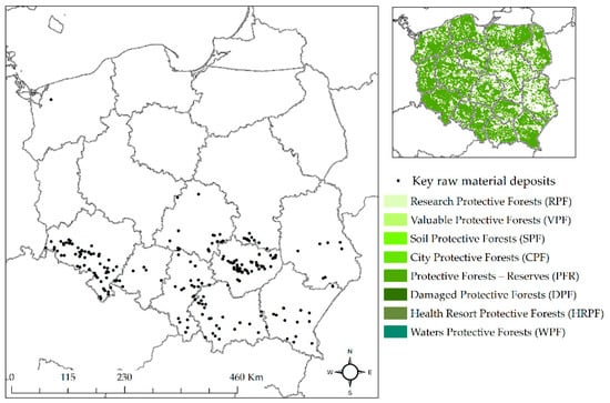
Figure 6.
Locations of the analyzed deposits within the areas of forests under particular protection (own study based on [24]).
Regulations do not prohibit the exploitation of minerals in the areas of protective forests. In cases justified by important social reasons and the lack of other land, protective forests may be used for other purposes, of course, after obtaining an appropriate consent from the competent administrative authority. However, in the case of areas of over 10 hectares and intended for mining projects, additional conditions must be met, which include providing alternative solutions (variants) for land reclamation and land management during and after the end of industrial activity. In addition, each of the variants should be presented together with the costs of reclamation and land management as well as with estimations of losses to be incurred by forestry and agriculture [25].
Investigations reveal 90 rock deposits documented within the areas of protected forests (Figure 7). According to the provisions of the Act on the Protection of Agricultural and Forest Land [25], all the above-mentioned deposits have limitations regarding the possibilities for their development. However, four deposits have been documented in an area smaller than 10 hectares and therefore can qualify as well accessible. The remaining 72 deposits have an area of more than 10 ha, so if their area is intended for purposes other than forestry, additional conditions resulting from the provisions of the Act on the Protection of Agricultural and Forest Land must be met. Therefore, they may be classified into accessibility zone III. Table 9 presents the results of deposit accessibility evaluations with relation to their locations within the areas of forests under particular protection.
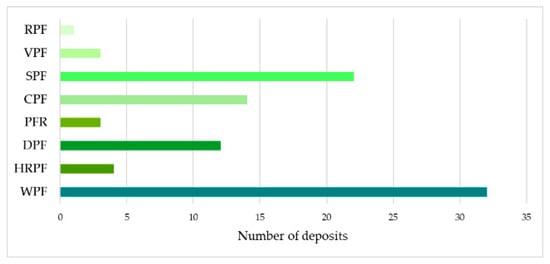
Figure 7.
Number of deposits located in forests under particular protection by forest type.
Table 9.
Evaluation of the accessibility of key raw material deposits located in areas of forests under particular protection.
3.1.3. Major Groundwater Reservoirs, Zones of Groundwater and Surface Water Intakes
Groundwaters are protected by documenting major groundwater reservoirs (Further: MGRs). MGRs are water-rich geological structures which constitute strategic groundwater resources for supplying the population and basic sectors of the economy (Figure 8). Prohibitions, orders and restrictions on land use in the protected MGR areas are defined in order to protect these resources against their depletion and quality degradation. Prohibitions or restrictions on works or activities relate to the aspects which may cause permanent contamination of soil or water. The prohibitions or restrictions in question are established in the form of an act of local law for a given protection area [26]. With the current mining technology, rock mineral exploitation is possible if safety measures are applied and if the environmental impact assessment procedure demonstrates no impact on the MGR. However, as the protection of water intakes is prioritized, legal acts establishing water intake zones prohibit the extraction of minerals.
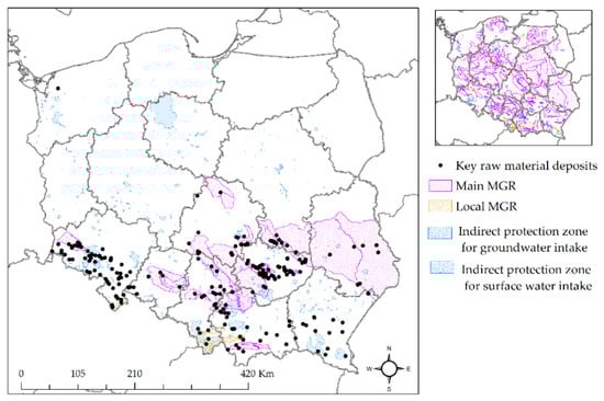
Figure 8.
Locations of the analyzed deposits in MGR areas and in groundwater and surface water intake protection zones (own study based on [14]).
The analysis of the presence of deposits in the areas of major groundwater reservoirs showed that this fact applies to 96 deposits. On the other hand, 21 deposits are located in the indirect protection zones of groundwater intakes, and 11 deposits in the indirect protection zones of surface water intakes (Figure 9).
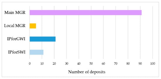
Figure 9.
Number deposits located in MGR areas and in groundwater and surface water intake protection zones.
The analysis of the formal and legal conditions together with the identification of the locations of deposits in the MGR areas and in the protection zones of groundwater and surface water intakes allow a three-level accessibility scale of key raw material deposits (Table 10).
Table 10.
Evaluation of the accessibility of key raw material deposits located in the areas of major groundwater reservoirs and in the indirect protection zones of groundwater and surface water intakes.
3.1.4. Surface Waters
The analysis of surface waters included the presence of flowing (rivers and streams) and stagnant (reservoirs) water resources on the surface of documented key raw material deposits. The research demonstrated that no surface water reservoirs are present in the areas of the analyzed deposits (Figure 10). However, in 17 cases, flowing waters were identified on the surfaces of the analyzed deposits. The presence of surface waters in the documented areas of the analyzed deposits was included in a two-level scale for assessing their accessibility (Table 11).
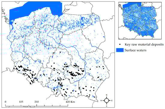
Figure 10.
Locations of the analyzed deposits in the areas of surface waters (own study based on [27]).
Table 11.
Evaluation of the accessibility of key raw material deposits located in the areas of major groundwater reservoirs.
3.2. Spatial and Social Analysis
The research on the accessibility of key raw material deposits concerned spatial and social aspects: the distance of the documented key raw material deposits from the nearest residential buildings as well as accessibility by road and rail. These factors were examined in terms of the impact of noise, the accessibility of road and rail transport, the latter being more beneficial for the local community. Road transport causes noise, vibrations, deterioration of the technical condition of roads or an increased nuisance for residents, and in the case of rail transport these aspects are not an issue or are much less important.
3.2.1. Housing Development Areas
The main factors determining the selection of the type and technology of exploitation are: the type of mined rocks and their physical and mechanical properties, the geological structure of the deposit, the intended use of the mined minerals along with the volume of extraction and environmental conditions. The two main methods that are used for mining non-metallic rock raw materials are mechanical mining and blasting. Mechanical mining is performed with the use of: high-power single-bucket excavators equipped with mechanical or hydraulic rippers, hydraulic hammers, falling balls or other devices. Mining by means of blasting is the basic method of extracting non-metallic raw materials. It allows relatively cheap production of large amounts of pre-comminuted material. However, this method produces scattered rock fragments, as well as air shock waves and seismic waves, which have a destructive effect on various objects in the vicinity of the mine. Therefore, ensuring safety conditions in the surroundings of blasting operations in the mine becomes essential [28,29].
The site where blasting works are performed should be surrounded by risk zones due to air shock waves, rock scattering and para-seismic vibrations of the rock mass in the manner specified in Annex 4 to the Regulation of the Ministry of Energy of November 9, 2016 on the detailed requirements for the storage and use of blasting materials and equipment in the operations of the mining plant [30]. These risk zones should allow the safety of people and protection of property against the effects of blasting works.
The above-mentioned annex was used in this research to define key deposit accessibility zones for housing development areas including compact housing estates, public utility buildings, industrial buildings, non-housing and historic buildings (Table 12). After outlining the buffer zones, an accessibility analysis was performed, which showed that 209 deposits are located within 1000 m from the built-up areas (Figure 11).
Table 12.
Evaluation of the accessibility of key deposits located within housing development areas.
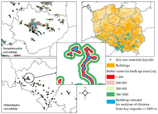
Figure 11.
Analysis of the accessibility of key deposits located within housing development areas (own study based on [27]).
3.2.2. Road and Rail Infrastructure
The mined non-metallic raw materials are usually transported by cars using the available road infrastructure and the operational railway infrastructure. Therefore, in this research the transport-related accessibility of key raw material deposits was evaluated on the basis of access to road and rail infrastructure. The road infrastructure within the research area includes national, voivodeship, district and local roads (Figure 12). In total, four zones of transport-related accessibility of the deposits were identified for the road infrastructure and described according to the key from Table 13. This accessibility is characterized with parameters developed on the basis of the spatial planning limits for deposit accessibility, as described in the paper by Radwanek-Bąk [31].
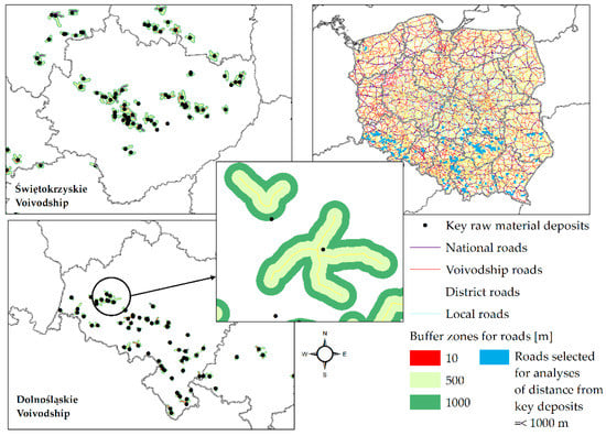
Figure 12.
Analysis of transport-related accessibility of key raw material deposits—road infrastructure (own study based on [27]).
Table 13.
Evaluation of transport-related accessibility of key raw material deposits—road infrastructure.
In the case of railway infrastructure, the following types of railway tracks were identified in the research area: standard running tracks, station running tracks and siding tracks (Figure 13). This step was followed with an analysis of the accessibility of deposits in zones designated around the railway infrastructure (Table 14).
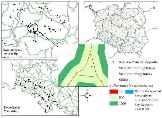
Figure 13.
Analysis of transport-related accessibility of key raw material deposits—railway infrastructure (own study based on [27]).
Table 14.
Evaluation of transport-related accessibility of key raw material deposits—railway infrastructure.
3.3. Evaluation of the Environmental and Social Accessibility of Key Deposits
After preparing an inventory list of environmental and social elements located in the selected research area, an evaluation was made of the accessibility of non-metallic raw material deposits explored in detail and classified as key raw materials in the environmental and social aspect. The evaluation was performed on the basis of seven variables influencing the accessibility of the deposit: forms of nature protection, forests with protective functions, indirect protection zones of groundwater and surface water intakes, major groundwater reservoirs, surface water reservoirs, rivers, streams and canals, buildings and road rail infrastructure. The impact of these variables on the analyzed deposits was identified according to the accessibility scale presented in Table 1. In the next step, an evaluation matrix was developed for the analyzed deposits (244 deposits), and filled with the evaluation results obtained for the above-mentioned variables. Table 15 presents fragments of result matrix.
Table 15.
Fragment of the matrix filled with variables.
Complete calculations of deposit accessibility were performed in two variants. In the first variant, all of the assumed variables were used. This variant provided the following results:
- deposit accessibility scale I (very well accessible)—0 deposits
- deposit accessibility scale II (well accessible)—5 deposits
- deposit accessibility scale III (accessible)—93 deposits
- deposit accessibility scale IV (inaccessible)—146 deposits.
Figure 14 shows the spatial distribution of the results.
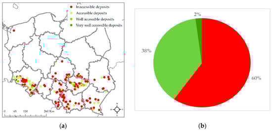
Figure 14.
Results of the accessibility analysis of non-metallic raw material deposits in the environmental and social aspect in Poland—variant 1: spatial distribution of the classification result (a) and the percentage of the classification result (b).
In the second variant of deposit accessibility evaluation, the railway infrastructure was not assessed. The railway infrastructure in the vicinity of the deposit was assumed not to be a decisive factor for its accessibility, as in most cases (90%) non-metallic raw materials are transported with the use of road vehicles [32]. As a result, the second variant was performed for six variables. The results in this variant were as follows: 145 deposits were classified as inaccessible, 68 deposits—as accessible deposits, 28 deposits—as well accessible deposits, and 3 deposits—as very well accessible deposits. Figure 15 shows the spatial distribution of the deposits according to the results.
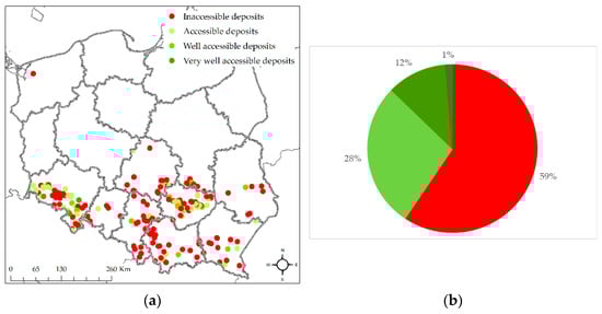
Figure 15.
Results of the accessibility analysis of non-metallic raw material deposits in the environmental and social aspect in Poland—variant 2: spatial distribution of the classification result (a) and the percentage of the classification result (b).
The following deposits have been classified as very well accessible: two deposits of road and building stones—Bieganów II (sandstone, resources of 15,245,000 tons) and Jordanów 1 (serpentinite, resources of 17,742,000 tons), and one deposit of vein quartz—Nowa Kamienica (resources of 113,000 tons). These deposits are located in the Dolnośląskie voivodship.
4. Discussion and Conclusions
The research demonstrated a number of environmental and social constraints limiting the exploitation of these deposits. The above fact applies particularly to the environmental constraints. The analysis showed that approx. 60% of the investigated deposits with total resources of approx. 6300 million tons are inaccessible, both in variant 1 (146 deposits) and in variant 2 (145 deposits). This means that these deposits have no development potential, despite their rich resources and despite being essential for the proper functioning of the economy and for satisfying the living needs of people (being thus a group of key raw materials). If the variable of accessibility to railway infrastructure is excluded, the situation differs for three deposits which are in such cases reclassified into class I of deposit accessibility—very well accessible. Table 16 shows the results obtained for both variants, together with the total resources for each accessibility class.
Table 16.
Evaluation of deposit accessibility for two variants.
In conclusion, environmental considerations play a decisive role in evaluations of deposit accessibility and in the vast majority of cases they completely exclude the possibility of mineral extraction. In other cases, obtaining a concession to extract a mineral from a documented deposit depends on the successful completion of the environmental impact assessment procedure followed by issuing a decision on environmental conditions for the project [2,3,4,5,6]. The social constraints (distance from facilities, as well as road and rail infrastructure) were observed to be of little significance in the evaluations of deposit accessibility. The built-up infrastructure is an important element in this group of variables, as it excludes, especially in class IV, the possibility of extracting minerals from the analyzed deposits.
Author Contributions
Conceptualization, J.G.-Z. and U.K.; methodology, J.G.-Z. and U.K.; software, J.G.-Z.; validation, U.K.; formal analysis, J.G.-Z.; investigation, U.K. and J.G.-Z.; resources, J.G.-Z. and U.K.; data curation, J.G.-Z.; writing—U.K. and J.G.-Z., original draft preparation, J.G.-Z. and U.K.; writing—review and editing, U.K. and J.G.-Z.; visualization, J.G.-Z.; supervision, U.K.; project administration, J.G.-Z.; funding acquisition, U.K. All authors have read and agreed to the published version of the manuscript.
Funding
This scientific work was financed within Statute Research Studies order No. RRD_PODST_BAD_EXP8201.
Institutional Review Board Statement
Not applicable.
Informed Consent Statement
Not applicable.
Data Availability Statement
The data cannot be made available due to the confidentiality agreement.
Acknowledgments
The authors would like to thank institutions listed in the paper for providing essential data.
Conflicts of Interest
The authors declare no conflict of interest.
References
- Fidrych, E.; Górecki, A.; Hodzyńska, M.; Marczak, A.; Pazik, A.; Szewczuk, K.; Tumiłowicz, J. Production of Industrial Products in 2000–2019; Walkowska, K., Ed.; Statistics Poland: Warsaw, Poland, 2020. Available online: https://stat.gov.pl/ (accessed on 23 September 2020).
- Radwanek-Bąk, B. Mineral deposits accessibility as a priority for mineral resources protection. Part. 2. Raw Mater. Mach. Constr. Ind. 2008, 1, 18–20. [Google Scholar]
- Radwanek-Bąk, B.; Sobczyk, W.; Sobczyk, E. Support for multiple criteria decisions for mineral deposits valorization and protection. Resour. Policy 2020, 68, 1–11. [Google Scholar] [CrossRef]
- Devenin, V.; Bianchi, C. Characterizing a mining space: Analysis form case studies in Chile and Australia. Resour. Policy 2019, 63, 1–17. [Google Scholar] [CrossRef]
- Kaźmierczak, U. Availability of Rock Raw Materials in The Context of Legally Protected Areas of The Dolnoslaskie Voivodeship. Miner. Resour. Manag. 2017, 30, 35–50. [Google Scholar] [CrossRef]
- Tiess, G. Minerals policy in Europe: Some recent developments. Resour. Policy 2010, 35, 190–198. [Google Scholar] [CrossRef]
- Gałaś, S. Assessment of implementation of protection of minerals deposits in spatial planning in Poland. Land Use Polisy 2017, 67, 584–596. [Google Scholar]
- Lesser, P.; Gugerell, K.; Poelzer, G.; Hitcg, M.; Tost, M. European mining and the social license to operate. Extr. Ind. Soc. 2020, 787, 1–8. [Google Scholar] [CrossRef]
- Moffat, K.; Zhang, A. The paths to social licence to operate: An integrative model explaining community acceptance of mining. Resour. Policy 2014, 39, 61–70. [Google Scholar] [CrossRef]
- Suopajärvi, L.; Umander, K.; Leneisja, J. Social license to operate in the frame of social capital exploring local acceptance of mining in two rural municipalities in the European North. Resour. Policy 2019, 64, 101498. [Google Scholar] [CrossRef]
- Woźniak, J.; Pactwa, K. Analysis of the socio-environmental policy of selected mining companieson the basis of non-financial reporting. Miner. Resour. Manag. 2019, 35, 177–194. [Google Scholar] [CrossRef]
- Radwanek-Bąk, B.; Galos, K.; Nieć, M. Pivotal, strategic and critical mineral raw materials for the Polish economy. Pol. Geol. Rev. 2018, 66, 153–159. [Google Scholar]
- Kulczycka, J.; Pietrzyk-Sokulska, E.; Koneczna, R.; Galos, K.; Lewicka, E. Key Raw Materials for the Polish Economy; Kulczycka, J., Ed.; The Publishing House of the Mineral and Energy Economy Research Institute of the Polish Academy of Sciences: Cracow, Poland, 2016; pp. 1–167. ISBN 978-83-62922-66-6. [Google Scholar]
- Central Geological Database. Available online: http://dm.pgi.gov.pl/ (accessed on 30 June 2020).
- Bońda, R.; Brzeziński, D.; Czapigo-czapla, M.; Czapowski, G.; Fabiańczyk, J.; Kalinowska, A.; Malon, A.; Mazurek, S.; Mikulski, S.Z.; Miśkiewicz, W.; et al. The Balance of Mineral Resources Deposits in Poland as at 31 December 2019; Szuflicki, M., Malon, A., Tymiński, M., Eds.; The Polish Geological Institute National Research Institute: Warsaw, Poland, 2020; pp. 1–498. ISBN (CD) 978-83-66593-57-2. [Google Scholar]
- Chmielewski, J. Protective forests. The contribution to the discussion on legal-administrative aspects of specially protected forests. Environ. Prot. Law Rev. 2014, 4, 88–110. [Google Scholar]
- Journal of Laws. The Nature Conservation Act, Act of 16 April 2004. Journal of Laws from 2020 Item 55. Available online: http://isap.sejm.gov.pl (accessed on 19 August 2020).
- The Central Register of Forms of Nature Conservation. Available online: http://crfop.gdos.gov.pl/CRFOP/ (accessed on 30 June 2020).
- Journal of Laws. Geological and Mining Law, Act of 9 June 2011. Journal of Laws from 2020 Item 1064. Available online: http://isap.sejm.gov.pl (accessed on 19 August 2020).
- Journal of Laws. Act on the Provision of Information on the Environment and Its Protection, Public Participation in Environmental Protection and on Environmental Impact Assessment, Act of 3 October 2008. Journal of Laws from 2020 Item 283. Available online: http://isap.sejm.gov.pl (accessed on 19 August 2020).
- Journal of Laws. Regulation of the Council of Ministers on Projects That May Significantly Affect the Environment, Regulation of 9 July 2010. Journal of Laws from 2013 Item 1397. Available online: http://isap.sejm.gov.pl (accessed on 5 August 2020).
- Kasztelewicz, Z.; Ptak, M. The procedure of environmental impact assessment in opencast mining in the light of law regulation with particular focus on the specific character of Nature 2000 areas. Miner. Resour. Manag. 2009, 25, 153–170. [Google Scholar]
- Journal of Laws. Act on Forests, Act of 28 September 1991. Journal of Laws from 2020 Item 6. Available online: http://isap.sejm.gov.pl (accessed on 19 August 2020).
- The Forest Data Bank. Available online: https://www.bdl.lasy.gov.pl/portal/en (accessed on 30 June 2020).
- Journal of Laws. Act on the Protection of Agricultural and Forest Land, Act of 3 February 1995. Journal of Laws from 2017 Item 1161. Available online: http://isap.sejm.gov.pl (accessed on 19 August 2020).
- Journal of Laws. Water Law, Act of 20 July 2017. Journal of Laws from 2020 Item 310. Available online: http://isap.sejm.gov.pl (accessed on 19 August 2020).
- Database of General Geographic Objects. Available online: http://www.gugik.gov.pl/ (accessed on 30 June 2020).
- Borcz, A.; Kozioł, W. Machine systems in opencast mining. Part. 1. Machines in Polish mining. Mod. Build. Eng. 2015, 4, 102–107. [Google Scholar]
- Kozioł, W.; Machniak, Ł.; Borcz, A. Strategic activities in the field of obtaining rock raw materials in the Opolskie Voivodeship. In Strategies and Scenarios of Technological Development and Utilization of Natural Stone Deposits in in the Opolskie Voivodeship; Kozioł, W., Machniak, Ł., Eds.; Poltegor-Institute Opencast Mining Institute in Wroclaw: Kraków-Wrocław, Poland, 2014; ISBN 978-83-60905-57-9. [Google Scholar]
- Journal of Laws. Regulation of the Ministry of Energy on the Detailed Requirements for the Storage and Use of Blasting Materials and Equipment in the Operations of the Mining Plant, Act of 9 November 2016. Journal of Laws from 2017 Item 321. Appendix 4. Available online: http://isap.sejm.gov.pl (accessed on 5 September 2020).
- Radwanek-Bąk, B. Valorisation of mineral deposits for protection purposes. Pol. Geol. Rev. 2005, 53, 434–438. [Google Scholar]
- Adamczuk, K.; Blachowski, J.; Kaźmierczak, W.; Koperdowski, J.; Lubieniecki, W.; Maciejewski, T.; Nakonieczna, I.; Owsianik, K.; Zakęś, A.; Zthey, M. Studies on the development of Lower Silesia. Study of the mining and transport of rock raw materials. Status Prospect. 2009, 1/34, 1–63. [Google Scholar]


Publisher’s Note: MDPI stays neutral with regard to jurisdictional claims in published maps and institutional affiliations. |
© 2021 by the authors. Licensee MDPI, Basel, Switzerland. This article is an open access article distributed under the terms and conditions of the Creative Commons Attribution (CC BY) license (http://creativecommons.org/licenses/by/4.0/).