Article

Flood Mitigation Using an Innovative Flood Control Scheme in a Large Lake: Dongting Lake, China

1
School of Hydraulic Engineering, Changsha University of Science & Technology, Changsha 4100114, China
2
School of Civil, Mining and Environmental Engineering, University of Wollongong, NSW 2522, Australia
3
Key Laboratory of Dongting Lake Aquatic Eco-Environmental Control and Restoration of Hunan Province, Changsha 410114, China
4
Key Laboratory of Water-Sediment Sciences and Water Disaster Prevention of Hunan Province, Changsha 410114, China
5
School of Mechanical, Materials, Mechatronic and Biomedical Engineering, University of Wollongong, NSW 2522, Australia
*
Author to whom correspondence should be addressed.
Appl. Sci. 2019, 9(12), 2465; https://doi.org/10.3390/app9122465
Submission received: 6 May 2019 / Revised: 5 June 2019 / Accepted: 13 June 2019 / Published: 17 June 2019
(This article belongs to the Section Civil Engineering)

Abstract

:

Featured Application

The Innovative flood control scheme could be applied to the flood-prone lake areas to mitigate the flood disaster.

Abstract

A large lake plays an important role in mitigating flood disasters in its nearby regions during the flooding period; however, the effect is limited, because most of its storage capacity becomes dead storage prior to the arrival of the flood wave. In the current study, an innovative flood control scheme (IFCS) is applied to Dongting Lake (the second largest freshwater lake in China) to alleviate flood disasters. MIKE 21 FM was used to examine its feasibility to mitigate flood disasters. One of the largest floods in the 20th century, the 1998-type flood, was modelled and the maximum water levels with/without IFCS were compared. The result shows that the effective flood control storage could be at least doubled when compared with the natural condition once IFCS was applied. The peak flood level in the Dongting Lake could be lowered by at least 0.32 m at the Chenglingji station in the same flood passage of Dongting Lake. The case study reveals that, after applying IFCS, the hydraulic gates play a very important role in floodwater regulation and further study should be conducted to find the optimized operation for each gate in the flood control scheme system.

Graphical Abstract

1. Introduction

Flood disaster causes the greatest losses among natural hazards and it has become more severe and most frequent in recent years due to climate change, urbanization, and water infrastructures. [1,2,3]. Economic losses from flood hazards have considerably increased over the recent decades [4]. Great floods result in great losses to the world as well as in China. During 1990–1998, most of the global significant flood disasters occurred in China [1], especially in China’s Yangtze River Basin, where about 40% of the national GDP in China is produced due to its abundant water. On the other hand, its economic development is constrained by these flood disasters, according to the Flood chronology of China.
Upstream dams on rivers (e.g., Three Gorges Dam (TGD, China) [5], Hoover Dam (America) [6], and Wivenhoe Dam (Australia) [7], etc.) can greatly regulate the inflow from their catchments, which can effectively reduce flooding. However, floodwater from the vast downstream area cannot be regulated, as there is no dam to control the flow. Relatively, the downstream river valleys, as well as the delta, have a higher population density and properties and any floods can cause huge losses, thus excessive floodwater management is most important. For example, there are two dams with a flood control capacity of 1.97 billion m3 in the Brisbane River catchment, but Brisbane city on the river delta was flooded twice in the 20th century, and the city was flooded again, leading to 35 deaths and $2.55 billion economic loss in 2011 [7]. The TGD is one of the largest dams in the world, with a flood control capacity of 22.1 billion m3, but it only controls 56% of the Yangtze River catchment area (see the shadowed area in Figure 1); floodwater from the downstream area cannot be controlled, even where the mega-cities, like Wuhan, Nanjing, and Shanghai, are situated. When the floods come from the middle or lower part of the Yangtze River basin, the TGD cannot effectively regulate the floodwater for the purpose of disaster mitigation, as happened in Brisbane in 2011. Therefore, it is worthwhile to investigate the flood control strategy in the downstream area of the dam. In the current study, we take the Dongting Lake, which is located downstream of the TGD, as an example to investigate how a lake can achieve a more effective role in mitigating a flood disaster in the middle or low part of a large river.
Generally, a large lake (i.e., the mean surface area is greater than 500 km2 [8]) plays an important buffer role for temporal floodwater detention during flood seasons [9,10]. However, a flood disaster still occurs when the incoming excessive floodwater is higher than a lake’s effective storage capacity, which usually becomes very small relative to its total storage, because safe floodwater occupies most of its total storage (small/medium scale flood) as the dead storage before the peak flood wave arrives [11]. For example, the severe flood-period of 1998 in China resulted in 3600 deaths and wreaked more than $30 billion in damages [1], even though its upstream dams and downstream lakes played some role in mitigating the loss. An innovative flood control scheme (IFCS) proposed by Yang [11,12] could be used to mitigate the flood disasters in a large lake to improve the effective flood control capacity of the lake to reduce the flooding loss. The IFCS consists of a by-pass canal with connecting sluice gates around the lake, which can be used to mitigate flood disasters by properly operating the sluice gates.
In this paper, the feasibility study of applying the new flood control scheme (IFCS) to the Dongting Lake was conducted while using the hydrodynamic module of MIKE 21 FM (flow model) with a long-time simulation (June to September 1998). The main objectives were to: (1) investigate the flooding process in Dongting Lake; (2) apply and design the IFCS into Dongting Lake; and, (3) examine its feasibility for the flood mitigation in Dongting Lake and its downstream region. This is the first attempt to investigate the application of the IFCS in Dongting Lake while using MIKE 21 FM. This study may provide useful information regarding flood mitigation in Dongting Lake and other similar lakes.

2. Materials and Methods
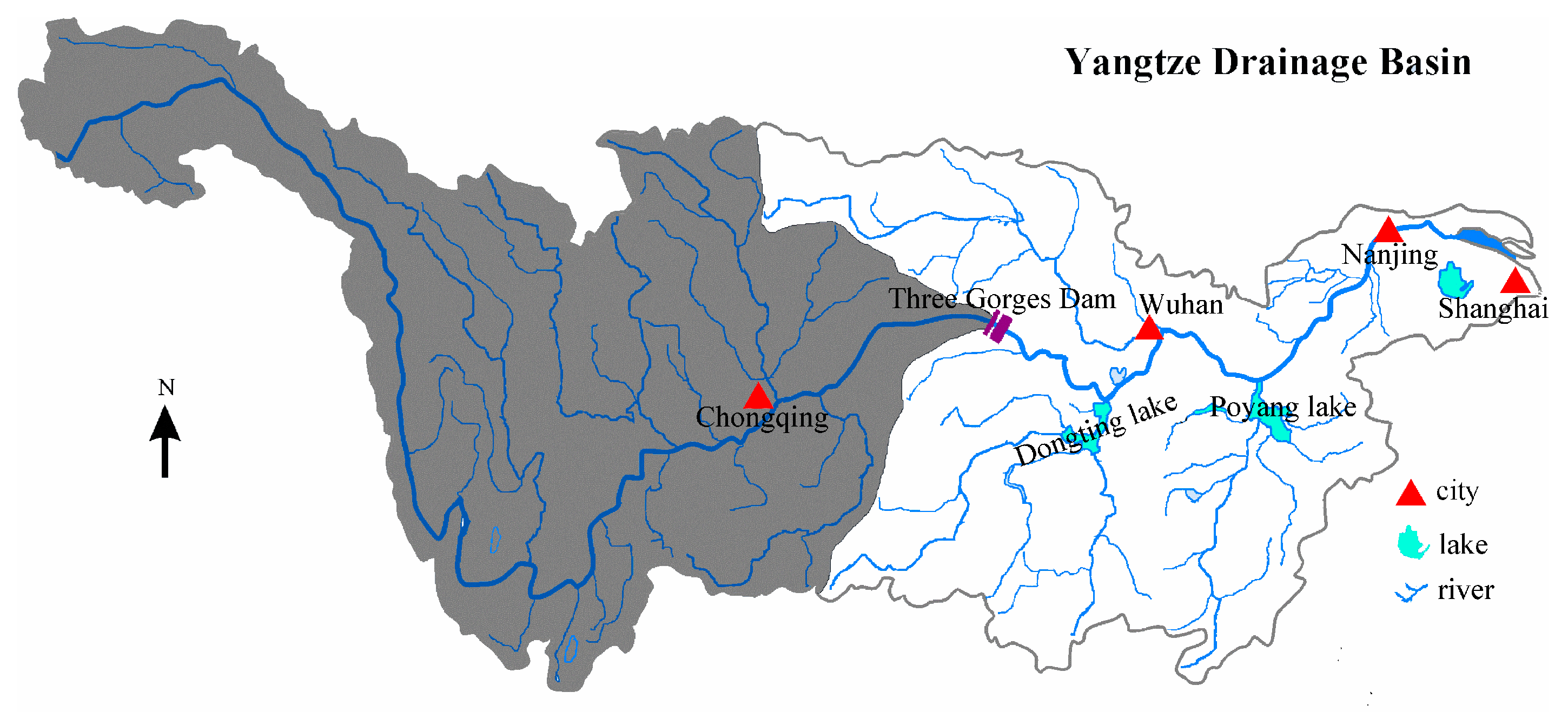
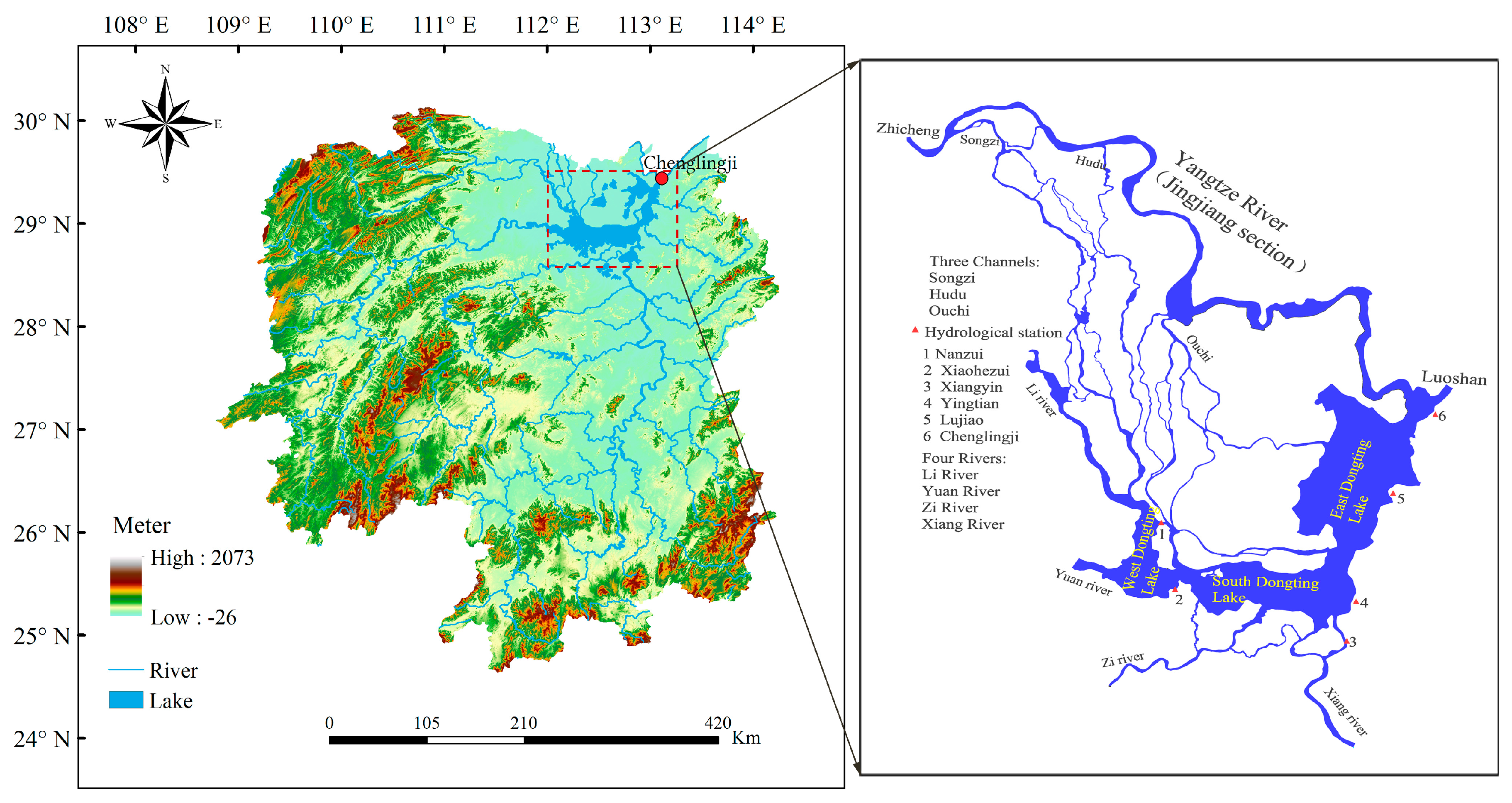
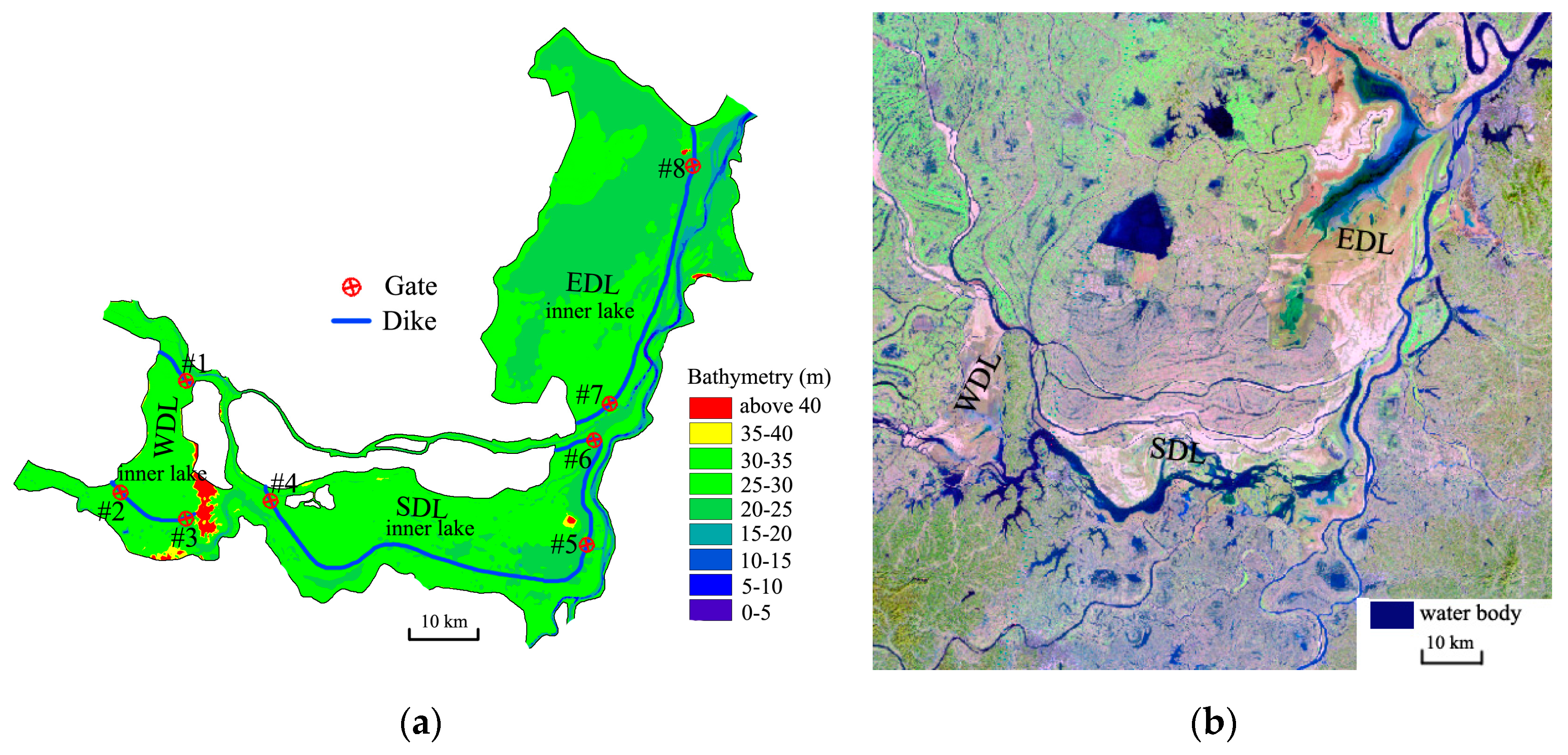
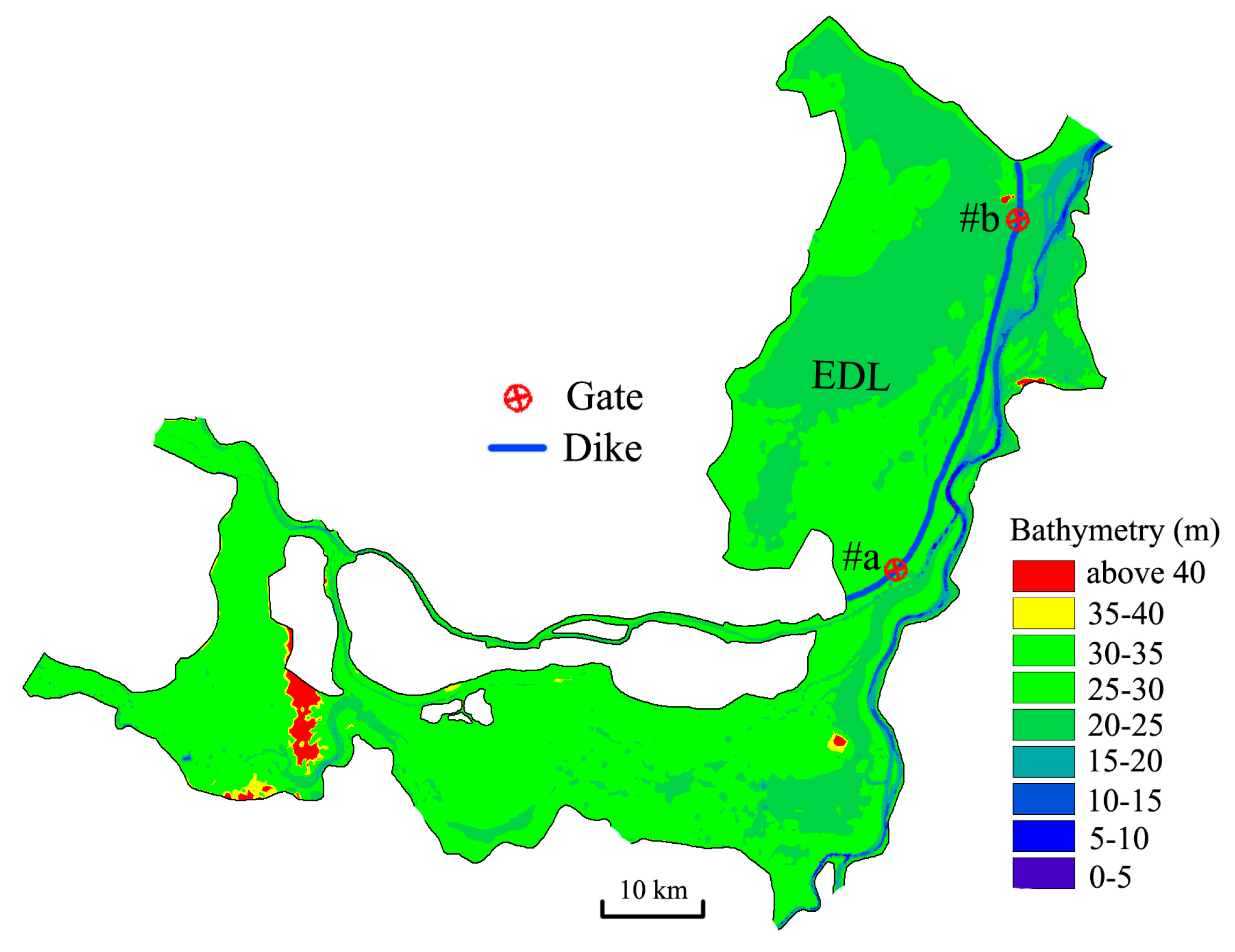
In this study, a hydrodynamic module of MIKE 21 FM was employed to investigate the IFCS’s effects on the flooding process in Dongting Lake. The hydrodynamic module was used to model the flow in the waterways of Dongting Lake. The required new dike with several hydraulic gates in the lake was designed to regulate the river flows into Dongting Lake. Mike 21 FM is a two-dimensional (2D) depth-averaged hydrodynamic model while using the fine volume method to solve the shallow water equations. The governing equations are:
h t + h u ¯ x + h v ¯ y = 0
u ¯ t + u ¯ u ¯ x + v ¯ u ¯ y + g η x + g u ¯ u ¯ 2 + v ¯ 2 C 2 h = v t ( 2 u ¯ x 2 + 2 u ¯ y 2 )
v ¯ t + u ¯ v ¯ x + v ¯ v ¯ y + g η y + g v ¯ u ¯ 2 + v ¯ 2 C 2 h = v t ( 2 v ¯ x 2 + 2 v ¯ y 2 )
in which h = η + d is the total water depth, d is static water depth, η is water level; t is the time; x and y are in Cartesian coordinates; u and v are the corresponding velocity components in x and y directions, respectively, u ¯ = 1 h d η u d z ,   v ¯ = 1 h d η v d z ; g is the gravitational acceleration (m/s2); C is the Chezy coefficient; and, vt is turbulence viscosity coefficient.
The hydrodynamic module of MIKE 21 FM has the capability of modeling the process of wetting and drying as water enters and leaves the area, which means that it is suitable for simulating water flow onto the dry land when the water level is relatively low in the lake. Many researchers have used the MIKE 21 FM model to investigate a large lake’s hydrodynamic process, like the Poyang Lake (China) [13], Dongting Lake (China) [14,15], and Vembanad Lake (India) [16], hence, only a brief description of the model is presented here.

2.1. Study Area

Dongting Lake is located at the northern end of Hunan Province in China, which lies between 28°20′–30°20′ N, 111°30′–113°15′ E (see Figure 2). It is the second-largest freshwater lake in China. The whole lake is divided into three main water bodies (West Dongting Lake, WDL; South Dongting Lake, SDL; and, East Dongting Lake, EDL). The total area of Dongting Lake covers approximately 2670 km2 in the flood season and it shrinks to 710 km2 in the annual dry season [17]. The lake receives water from the Yangtze River through three channels (Songzi, Hudu, and Ouchi) and four local rivers (Xiang, Zi, Yuan, and Li) and discharges to the Yangtze River via Chenglingji channel, where a flood control station is situated (Figure 2). During the period from 1951 to 2010, the three channels contribute approximately 31.3% of Dongting Lake’s inflow, while the four rivers account for 58.2% of its inflow [17], and 100% of lake water flows to downstream via the Chenglingji channel.

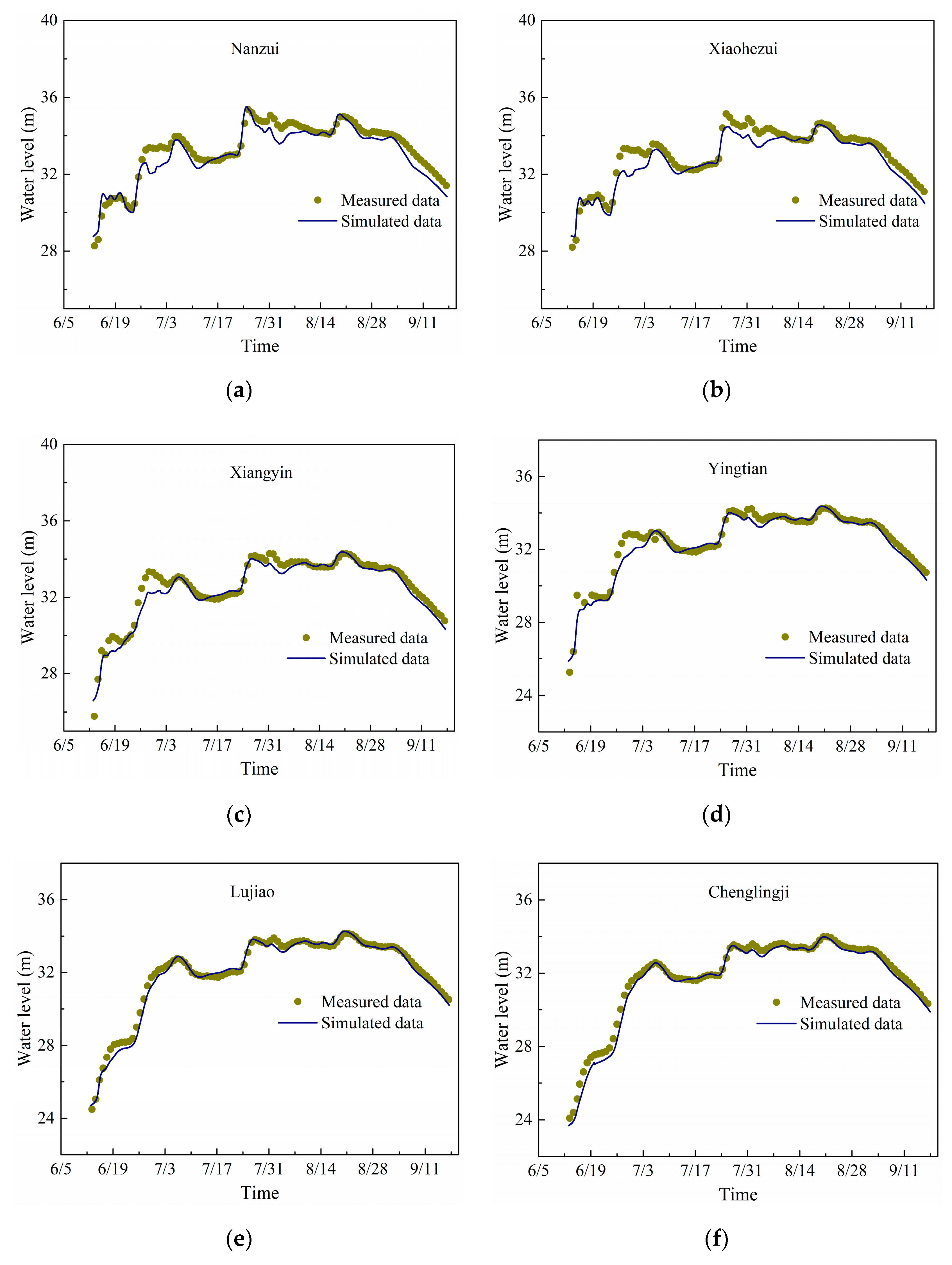
2.2. Calibration and Validation of the Model

A 2D depth-averaged hydrodynamic model based on MIKE 21 FM was applied to investigate the flooding process in the Dongting Lake area, which includes a part of the Yangtze River (i.e., Jingjiang section), Dongting Lake, and its main tributaries. The topography data of the Dongting area and the Yangtze River was based on the surveyed data, with a resolution from 30–200 m updated in 2003 and 2016, respectively. Unstructured triangular grids that can be adapted to the complex shape of the Dongting Lake area and vary in different grid sizes in any region were used to construct the model. In order to improve the computational efficiency and accuracy, a higher mesh resolution (30 m) was used in the channel and a coarse mesh (700 m) covered the Dongting Lake. Therefore, a total of 118,542 nodes and 210,341 triangular elements were included in the grid system with a minimum and maximum element size of 30m and 700m, respectively. Daily catchment inflows from Yangtze River and four rivers were specified as the upstream boundary conditions in the model. Luoshan gauging station on the Yangtze River was set as the downstream boundary of the model while using the rating curve that was observed at Luoshan gauging station.
The model has been calibrated to obtain the proper Manning’s roughness coefficient (M), which is the most important parameter in hydrodynamic modeling of rivers and lakes, while using the daily measured data during the flood period in 1996 (i.e., from 11 July to 2 August). In the current model, the value of M was initially set at 32 m1/3/s and then modified during the calibration. The calibrated M ranges from 32 m1/3/s to 60 m1/3/s in Yangtze River; 45 m1/3/s to 50 m1/3/s in the three channels, and 32 m1/3/s to 60 m1/3/s in Dongting Lake, as well as in the four rivers, which agree well with the previous studies [18].
A simulation was conducted to validate the current model while using the observation data from the flood period in 1998 (i.e., from 6 June to 17 September). The minimum time step was set to 2 s and the run time is about seven days using a computer with i7-4790 CPU (3.6 GHz, Intel Core, LENOVO, Beijing, China). The Nash–Sutcliffe efficiency coefficients (NSE) [19] of water level and the difference of the maximum water level between the measured and simulated data are given in Table 1 to estimate the accuracy of the current numerical model.
Table 1 shows that all of the NSE values are over 0.87, the R2 values are greater than 0.928, and the RMSE values are less than 0.484, which indicate that the calculated results agree well with the observations. Generally, the NSE values are close to previous studies [20]. Table 1 also shows that the difference of the maximum water level between the measured and simulated data is less than 0.16 m at all selected stations in Dongting Lake, which indicated that the current model could represent the flood well. Figure 3 shows the time series of water level at the main hydrologic stations in Dongting Lake. The results show that the model appears to simulate the noticeable water level fluctuation of the lake successfully, since the calculated results include the flood rising and falling process and the flood peak value agrees well with the measured data. Although there are some differences between the simulated data and measured data, the numerical simulations reasonably agree with the observations overall, which indicated that the current model can dynamically simulate the flooding process in Dongting Lake.

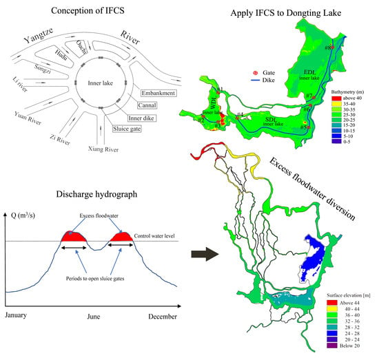
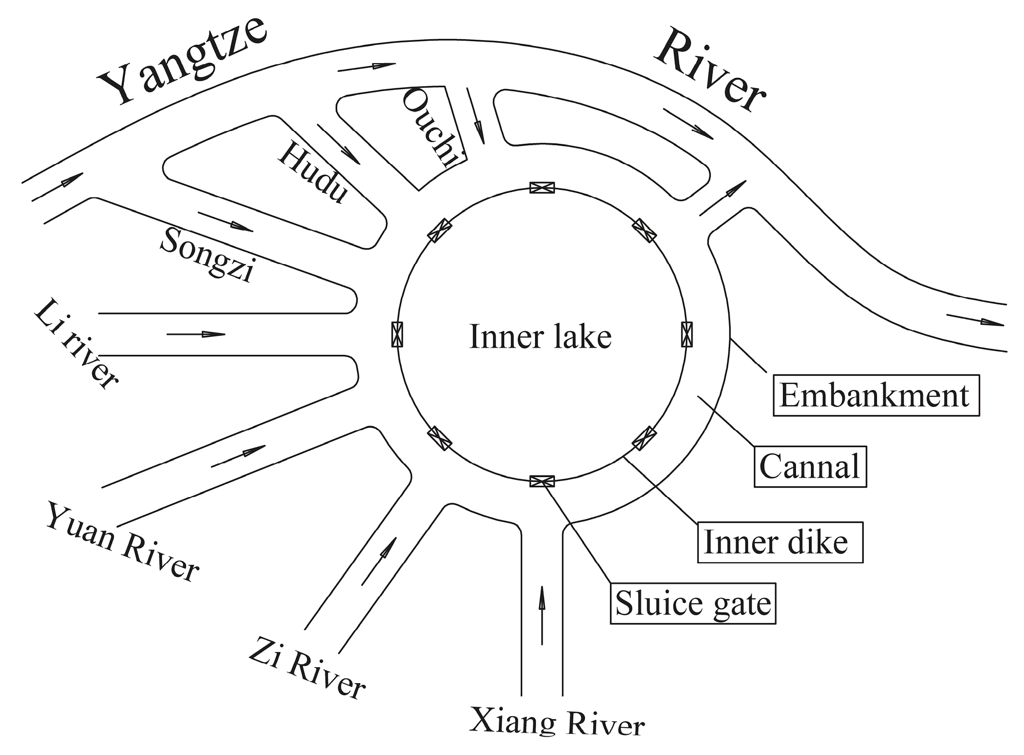
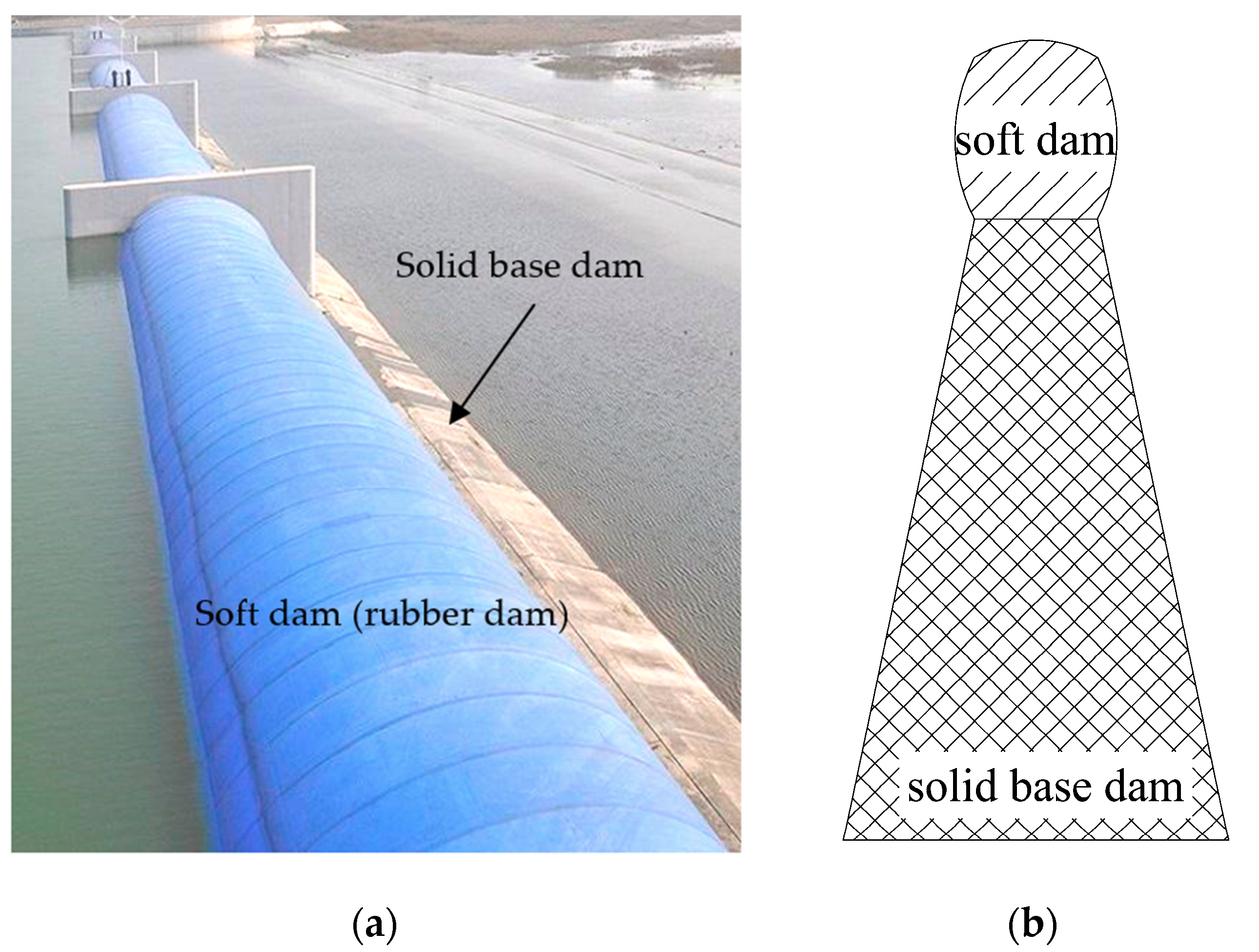
2.3. The Conception of IFCS and its Preliminary Design in Dongting Lake

Besides the existing dike surrounding a lake, the IFCS needs one more dike (the inner dike) parallel to the existing dike to form a by-pass canal that mainly consists of the inner dike in the lake; sluice gates are installed in the inner dike (see Figure 4). The inner dike could separate the inner lake and main channel. Thus, the excess floodwater could be diverted into the inner lake for storage, while the safe floodwater will be discharged to downstream without storage by closing the gates when the safe flood appears. Therefore, effective flood control capacity could be greatly increased, since the safe flood would not occupy the inner lake’s capacity.
The application of the IFCS in Dongting Lake needs to require designing the inner dikes and sluice gates in the lake, and Figure 5a shows the preliminary design, where the inner dike is represented by thick and solid blue lines and the hydraulic gates are marked by numbers with void red circles with a cross inside. The inner dikes are built along the main channel, which can easily be recognized according to the water body in the dry season of Dongting Lake (see Figure 5b). The area of the inner Lake of WDL, SDL, and EDL is 190 km2, 560 km2, and 969 km2, respectively. The water level in the inner lake should drop to its ecological water level, which is corresponding to basic water requirement [21] (i.e., 29.0 m in WDL, 27.5 m in SDL, and 26 m in EDL, which are calculated while using the lake morphology [22]) before the arrival of the flood wave in the wet season [11]. Therefore, the Dongting Lake could be nearly empty and thus the lake has sufficient effective capacity to store the excess floodwater. The sluice gates will be opened to let the excess floodwater enter into the inner lake when the peak flood wave arrives [11], and the safe floodwater could be discharged to the downstream through the main channel by closing the sluice gates.

3. Results

For a major flood, such as in 1998, the operating water level of the gate could be determined based on the safe water level, which is a designed water level for flood protection [23] at each hydrological station (see Table 2). We take gate #8, for example, to explain how the IFCS works to mitigate flood disasters. In the current study, the gate will be opened when the water level is greater than the safe water level (i.e., 32.50 m at Chenglingji station), until the water level reaches its peak value. For the 1998 type flood, the flooding process can be divided into three main flood waves, i.e., first flood wave (3–11 July), second flood wave (22–30 July), and the third flood wave (16–25 August) (see Figure 6).

3.1. The Effective Flood Control Capacity

The effective flood control capacity (EFC) can be calculated, as follows:
V e = S × Δ h = S × ( H m a x h i )
where Ve (m3) is the effective flood control capacity, S (m2) is the surface area of each lake, Hmax (m) is the maximum water level in each flood wave, and hi (m) is the incipient rising water level.
Table 3 shows the EFC of each part of Dongting Lake (i.e., WDL, SDL, and EDL) for the 1998 type flood before and after the application of the IFCS. For the natural condition, the total EFC of Dongting Lake is about 1.44 billion m3, 3.35 billion m3, and 1.45 billion m3 in the first, second, and third flood wave, respectively. The largest EFC occurred in the second flood wave due to the biggest variation range of the water level ( Δ h ). The IFCS has a dramatic effect on the Δ h in EDL. The Δ h significantly increases in EDL, which is about nine times, 4.7 times, and 2.8 times higher than that in the natural condition for the first, second, and third flood wave, respectively. Therefore, the EFC has significantly increased in EDL, i.e., 6.37 billion m3, 7.28 billion m3, and 2.16 billion m3 in the first, second, and third flood wave, respectively. For the WDL and SDL, the Δ h decreases a little in the first and the second flood wave and it is almost the same in the third flood wave. Hence, the EFC decreases a little or it is nearly the same as that in the natural condition. However, due to the EDL contributing the most EFC in Dongting Lake (see Table 3), the total EFC of Dongting Lake significantly increases, which is about 4.7 times, 2.8 times, and two times higher than that under the natural condition during the first, second, and third flood wave, respectively, after the application of the IFCS.

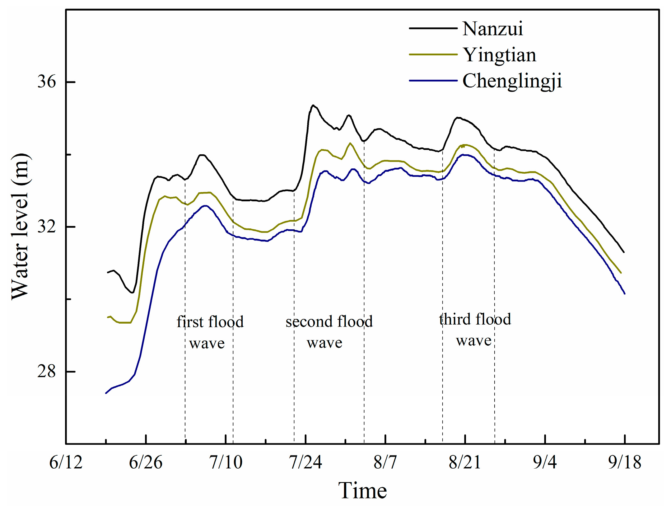
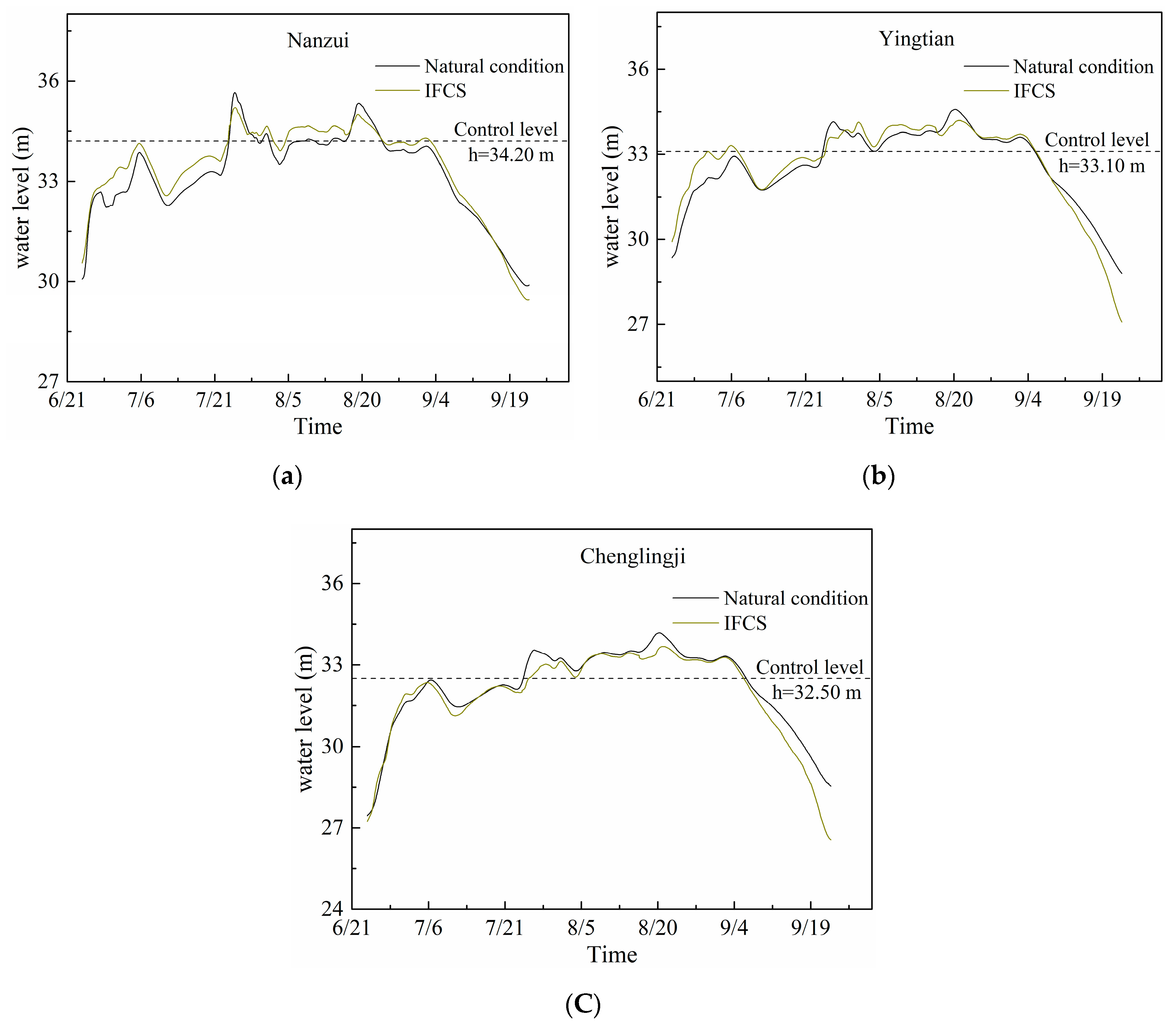
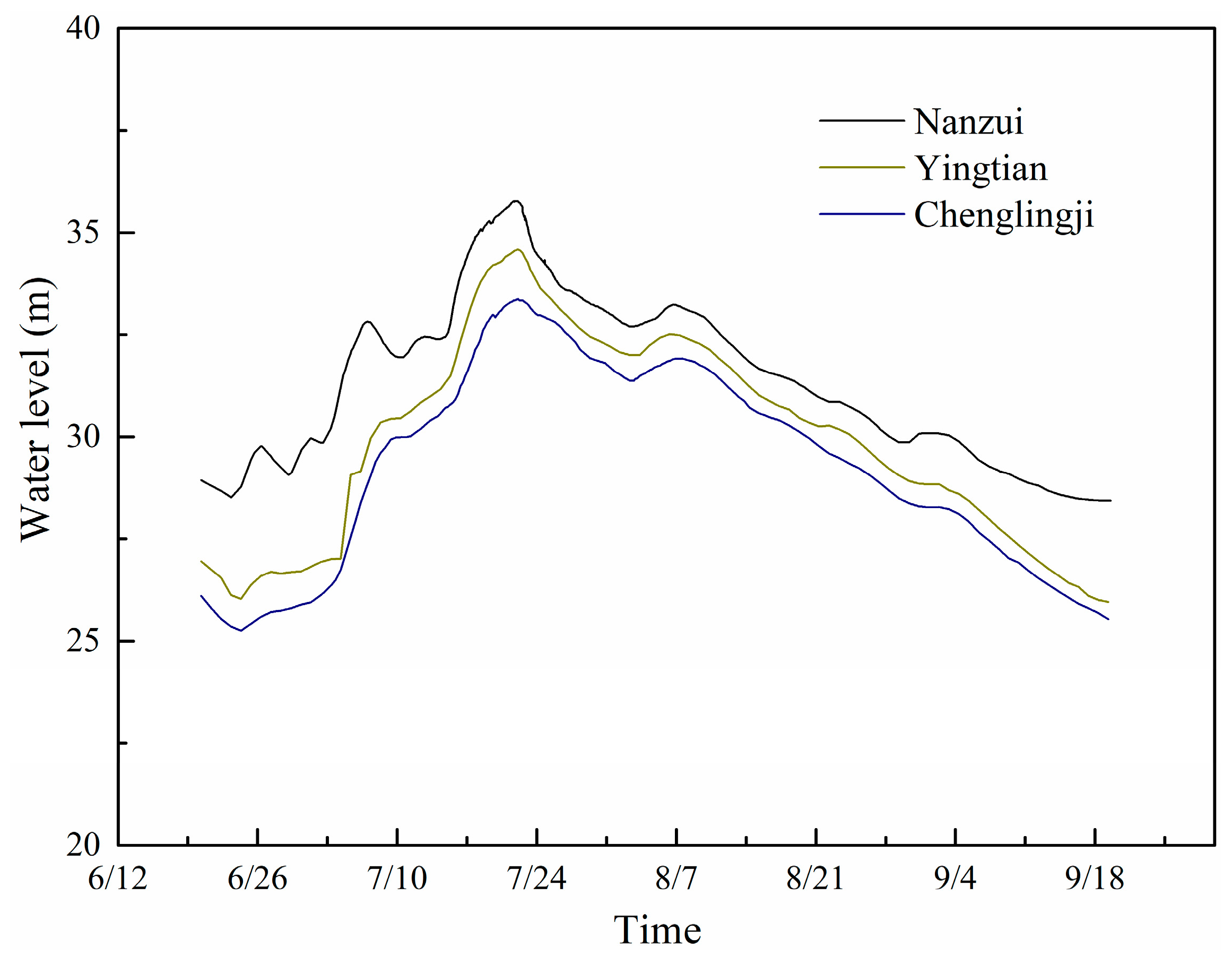
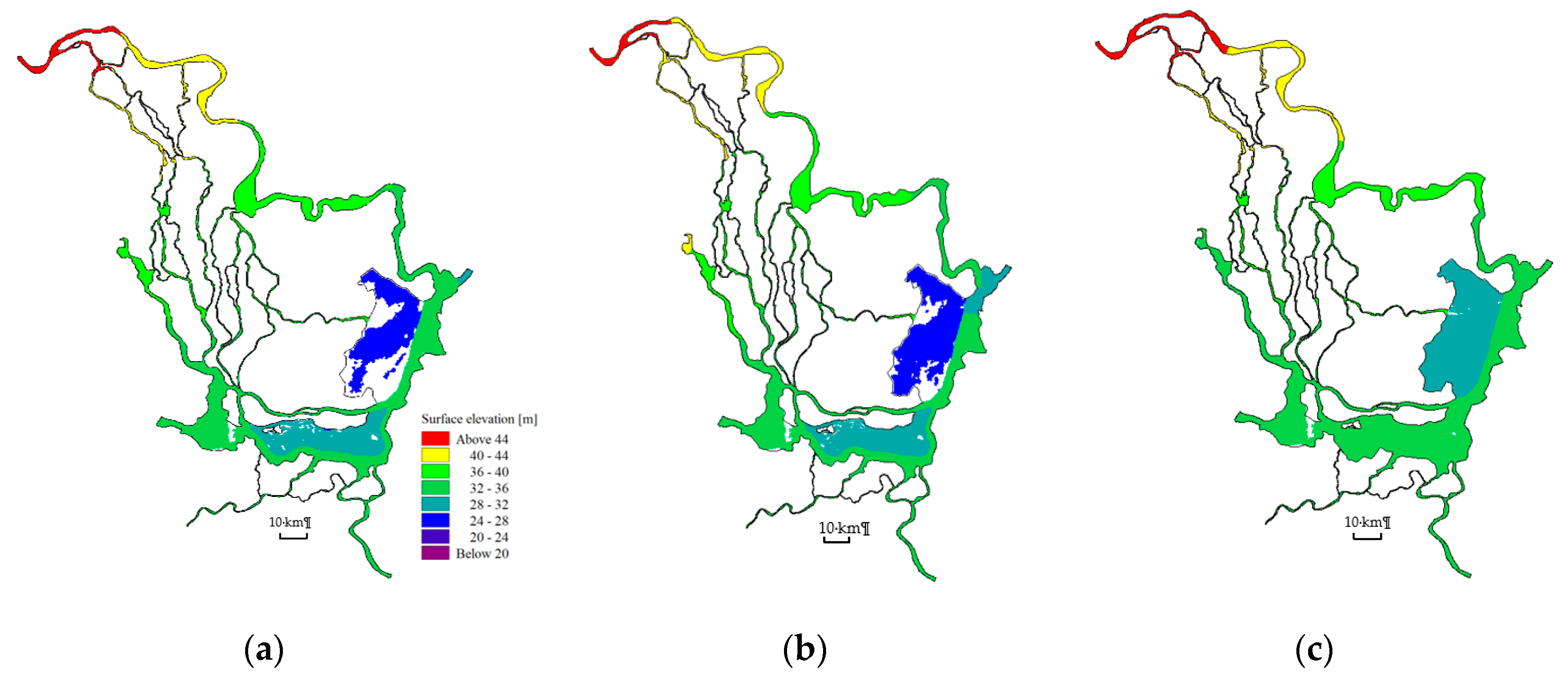
3.2. The Water Level

The flood process responses to the application of the IFCS in Dongting Lake under one of the largest floods in the 20th century, i.e., 1998 type flood (24 June to 22 September), was calculated based on the numerical model. Figure 7 shows the fluctuation of the water level in West Dongting Lake (WDL, Nanzui station), South Dongting Lake (SDL, Yingtian station), and East Dongting Lake (EDL, Chenglingji station). The results show a significant difference in the flood stage with the IFCS and the peak water level significantly decreases in the second and third flood wave period. Figure 7a shows that the water level is higher than that under the natural condition due to the narrowing of the flow cross section by the dike before the gate opens when the water level is less than the control level. The water level dramatically decreases, e.g., the second and the third flood wave, when the water level is higher than the control level. The average reductions of the water levels are about 0.18 m and 0.15 m in the second and third flood wave period, respectively. The variation of water level at Yingtian station (see Figure 7b) and Chenglingji station (see Figure 7c) is similar to the Nanzui station. For Yingtian station, there is a short period when the water level is still higher than that without IFCS, even when the gate is opened (i.e., the water level is higher than control level) during the first flood wave period (see Figure 7b). This can be explained by the fact that the gate opening period is too short (i.e., about 1 day) and the water level is only slightly higher than the control level, resulting in a limited excess floodwater being be mitigated into the inner lake. Therefore, the reduction of the water level is slight. However, the water level reduction is significant in the second and third flood wave, i.e., the average reduction of the water levels are about 0.10 m and 0.20 m, respectively. For Chenglingji station, the average reduction of the water levels are about 0.25 m and 0.18 m in the second and third flood wave period, respectively.
The highest water level is the most important factor in estimating the potential flood loss. Hence, the second and third flood wave were chosen to analyse the change of the highest water level after applying the IFCS due to the highest water level in the WDL occurring in the second flood wave and the highest water level in the SDL and EDL occurred in the third flood wave (see Figure 6). Table 4 shows the difference in the peak water level in the second and third flood wave before and after the use of IFCS at all the selected hydrological stations. During the second flood wave, the peak water level considerably decreases at Nanzui station (in the south of WDL), Lujiao station and Chenglingji station (in the EDL). However, it only decreases a little at Xiaohezui station (in the north of WDL) and Yingtian station (in the SDL). As for the third flood period, the peak water level decreases at least 0.32 m at all of the selected hydrological stations. It indicates that the IFCS could mitigate about 0.83 billion m3 excess floodwater at the flood peak point.

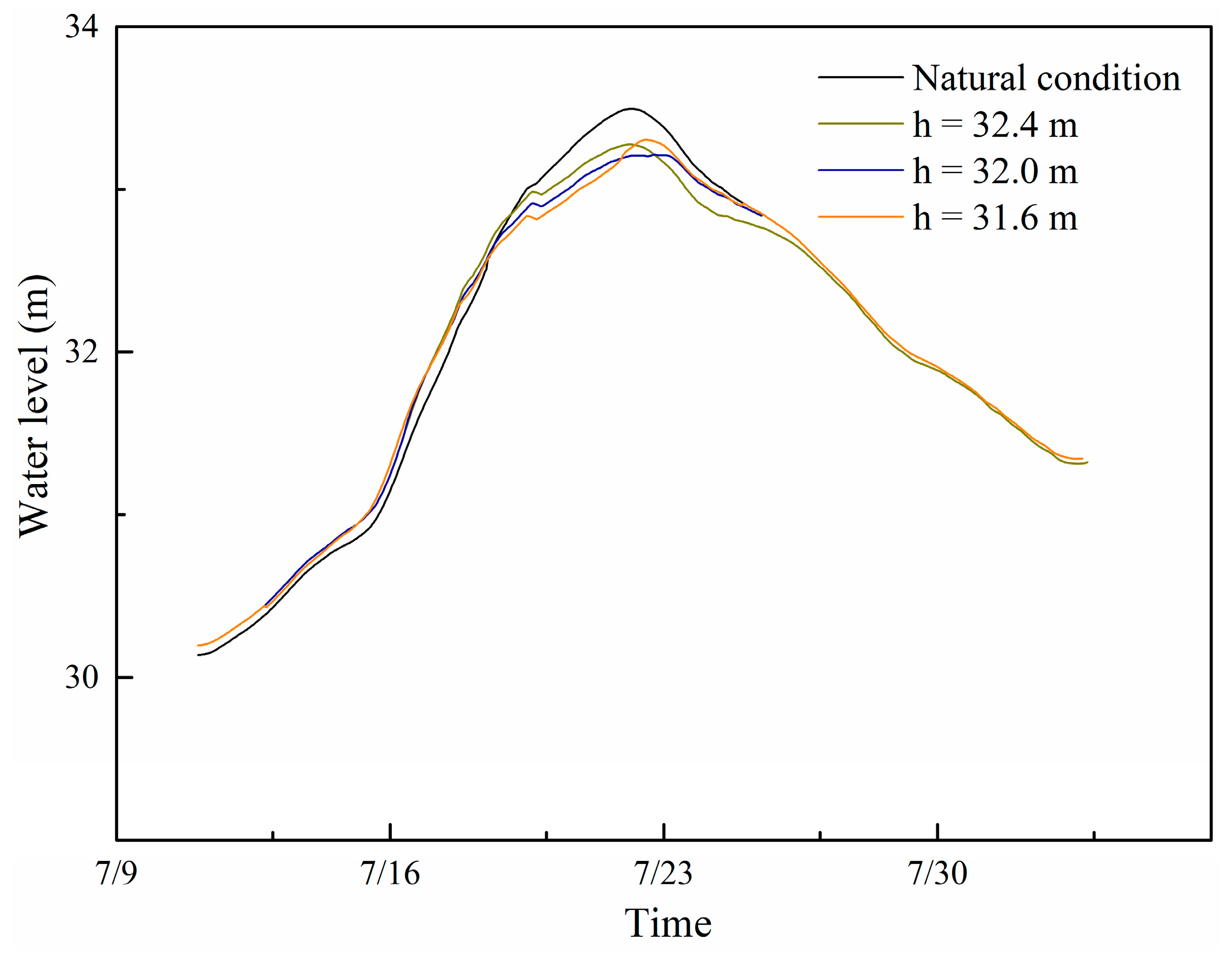
3.3. The Operation of the IFCS

The results show that the IFCS could effectively lower the water level during the flood season, especially in the EDL (East Dongting Lake) area (see Table 4). However, the operation of the IFCS has great effect on the water level reduction and the water level could be even higher than the natural condition if the wrong operation is chosen. Therefore, we built another model to explore the effect of the gate operation on the water level reduction. The 1996 type flood was chosen, as there was only one big flood peak in this year (Figure 8) and IFCS was only adopted in the East Dongting Lake (see Figure 9) to avoid the operation in each lake affecting the other. Table 5 shows the operating water level of the gate, i.e., when the water level reaches this value, then the gate will be opened to mitigate the floodwater into the inner lake.
Figure 10 presents the simulated fluctuation of the water level at Chenglingji station to show the effect of the operation on the water level reduction during the flood period. Before the gate is opened, there is a period (11–18 July) when the calculated water level is higher than that in the natural condition as the floodwater is restricted in the main channel after building the dike in the EDL. The water level begins to decline after the gate opens due to the excess floodwater flowing into the inner lake. For case 1, the operation water level was set as equal to the safe water level, with a corresponding peak water level reduction of 0.22 m. When the operation water level of both gates decreases by 0.02 m (Case 2), the reduction of the water level is more efficient, and the peak value is decreased by 0.28 m. However, instead, the reduction of peak water level decreases to 0.19 m when we continue to decrease the operation water level by 0.02 m (Case 3).

4. Discussion

4.1. Flood Control Effectiveness of IFCS and its Operation

The hydrodynamic model was applied in the Dongting Lake area in order to evaluate the flood mitigation ability of the IFCS. We compared the effective flood control capacity and the difference of maximum water levels of the same hydrograph with/without IFCS, and the hydrographs in 1998 were chosen as an example.
In the natural conditions, the effective flood control capacity (EFC) is limited, because the safe floodwater occupies most of the capacity of the lake prior to the arrival of the flood wave. Take the East Dongting lake as an example, the EFC is only about 0.71 billion m3 during the first flood wave under the natural condition (see Table 3). However, the EFC could be greatly increased after the application of the IFCS, as the safe floodwater is not allowed to enter the inner lake. Therefore, the EFC increases to 6.37 billion m3, which is about nine times larger than that in the natural condition, as the EDL is nearly empty before the first flood wave arrives (see Figure 11a). During the second flood wave, the natural EFC of EDL increases to 1.54 billion m3, while it becomes 7.28 billion m3 with the IFCS. It is about 4.7 times larger than that in the natural condition, because the water level in EDL is still very low before the second flood wave arrives (see Figure 11b). As for the third flood wave, the flood control capacity of Dongting Lake could still be increased to 2.16 billion m3, which is nearly 2.8 times larger than that under the natural condition due to the fact that the water level in the inner lake is still lower than that in the main channel, which indicated that there was still extra floodwater storage capacity in the EDL (see Figure 11c).
The Chinese Central Government proposed a policy known as ‘‘return land to lake’’ after the 1998 flood to control the water level in Dongting Lake [5]. The lake embankment would be removed and the land surrounding the Dongting Lake would be converted into a lake area to increase the capacity of the lake. The “return land to lake” policy has a positive effect on the flood control in Dongting Lake area, which was investigated by Jiahu (2017) [18] while using a numerical simulation method. The water surface area has been gradually increased in recent years [23], but it is proceeding very slowly, because it has dramatic effect on the people who live in that area, since they have to move out of that place. However, the IFCS increases the flood control capacity by exploring and developing the potential flood control capacity of the lake itself, and thus it has little effect on the people who live in the lake’s surrounding area.
The operation of the hydraulic gates in the IFCS has a significant effect on flood mitigation. If the operating water level; (i.e., the gate will be opened when the water level is over this level near the gate) is too high, as a consequence, the gate would open relatively late, which indicated that there is not enough time to let the excess floodwater enter into the inner lake. Therefore, there is still extra water storage capacity in the inner lake and the peak water level could be further reduced when comparing Case 1 with Case 2. If the operating water level is too low, the floodwater would enter the inner lake too early. This part of the floodwater would occupy some part of the lake storage capacity, resulting in there not being enough effective capacity to store the excess floodwater when the peak flood discharge arrives. Hence, the reduction of the peak water level would decrease when comparing Case 3 with Case 2. Thus, the operating water level of the gate plays a very important role in floodwater mitigation, which still needs further study of the operating water level for a particular gate to obtain the optimized water level reduction, especially in a complex system that includes several gates to be required in the IFCS. Additionally, some other factors of the gate (e.g., the width, height, and gate opening, etc.) that affect the operation of the gate were not incorporated in the current model, since the current study focuses on applying and estimating the feasibility for flood mitigation of the IFCS in a large lake. Therefore, future study might be necessary to consider the abovementioned factors to obtain the optimized water level reduction.

4.2. Design of the Dike and its Cost

How to design and build the huge dike in the large lake is the key point for the IFCS. The huge dike could combine a solid base dam and a flexible soft dam (e.g., rubber dam, see Figure 12) on it. Taking the #1 dike in the West Dongting Lake (see Figure 5a) with a 50-year flood standard for the IFCS, for which the water level is 35.36 m (see Figure 13) at Nanzui station as an example, the top elevation of the inner dike should be 35.36 m with level of 33.0 m of the solid base dam and a height of 2.36 m of the flexible soft dam. For a normal flood, if the water level reaches the control level (i.e., 34.2 m in the current study) at Nanzui station, the #1 gate would be opened to store the excess floodwater. However, for an extreme huge flood (e.g., 50-year flood), the flexible soft dam should be inflated by air or water, and the top height could be lowered to nearly 33.0 m if the soft dam is deflated and the main channel is higher than 35.36 m and it is still increasing at Nanzui station. Therefore, the water level is at least 2.3 m higher than the dike. We can assume that the lake with IFCS is back to the natural condition and the dike has little effect on the flood propagation. However, more experiments and numerical simulations should be conducted to estimate the effect of the dike on the flood propagation in the lake in the future.
Based on our assumption of the dike in Dongting Lake, the whole length of the dike is about 160 km and the average unit cost of the dike is about US$1.635 million per kilometer [11]. Hence, the total costs are about 1.633 × 160 = US$ 261.28 million. If we take three times as the estimated value for a conservative estimation, the total cost is about US$ 783.84 million, which only accounts for 32.4% of the direct economic losses (i.e., US$ 2.42 billion) that are caused by the 1998 flood disaster in the Dongting Lake area.

4.3. The Feasibility Analysis of the IFCS for Other Large Lakes

The feasibility of a similar scheme was analyzed in Taihu (i.e., the third largest fresh water lake in China) by Yang (2010). It was found that there was only 14.6% of the total storage for flood control under the natural condition for the 1997 type flood, while the effective flood control capacity would be increased to 90% of the total storage with the new scheme. The IFCS can also be applied into other flood-prone lake areas, such as Tonle Sap Lake (Cambodian) and Poyang Lake (China). The water depth in Tonle Sap fluctuates from 1.5 to 10 m with the corresponding surface area from 2600 to 15,000 km2 [24]. We assumed the minimum lake area as the inner lake (i.e., 2600 km2). After the application of IFCS into Tonle Sap Lake, the water level difference is 8.5 m (from 1.5 m to 10.0 m) in the inner lake resulting in the total flood control capacity being increased by 22.1 km3 (= 8.5 m × 2600 km2), which is 27.6% of the total storage (80 km3, Yu (2019) [25]). For the Poyang Lake, the surface area ranges from 714 to 3164 km2 during 2001–2010 [26]. We assumed that the surface area of the inner lake is about 64% of the maximum lake area (i.e., about 2025 km2), according to the preliminary design of the IFCS in Dongting Lake. The safe water level is 19.50 m and the highest water level recorded in history is 22.50 m (2 Aug. 1998) in Poyang Lake [27]. Hence, the water level difference is 3.0 m, with the corresponding flood control capacity of 9.49 km3 (= 3.0 m × 3164 km2). The ecological water level is 12.07 m in Poyang Lake [28], and thus the difference between the maximum water level and the ecological water level is 10.52 m in the lake. Therefore, the flood control capacity could be increased to 21.30 km3 (= 10.52 m × 2025 km2) with the IFCS, which is 2.24 times larger than that under natural condition. Based on the above analysis, the IFCS has great potential to increase the flood control capacity of the lake, and thereby to mitigate the flood disaster in the flood-prone lake area.

4.4. Limitation of the IFCS and the Current Model

The flow field in the lake and the water exchange between the lake and river would be dramatically changed after building several dikes in the lake although the IFCS could significantly mitigate the excess floodwater during the flood season. Thus, the effect of the IFCS on the sediment transport and water environment should be further studied. Some factors (e.g., wind forcing, drag coefficient, and precipitation-evaporation, etc.) that affect the hydrodynamic process were not incorporated in the current model, due to the lack of these data. Hence, future study may be necessary to consider the abovementioned factors for a more accurate simulation of the hydrodynamic process.

5. Conclusions

To further mitigate flood disasters, there is a need to regulate the downstream flood, as dams can only control the flood from upstream of the dam. In this study, we examined the feasibility of an innovative flood control scheme (IFCS) to mitigate the excess floodwater in Dongting Lake, which is located downstream of the Three Gorges Dam. The highest water level in a major flood is specially modelled and compared while using a 2D depth-averaged hydrodynamic model, i.e., MIKE 21 FM, which was applied to model the Dongting Lake. The following conclusions can be drawn from the current study:
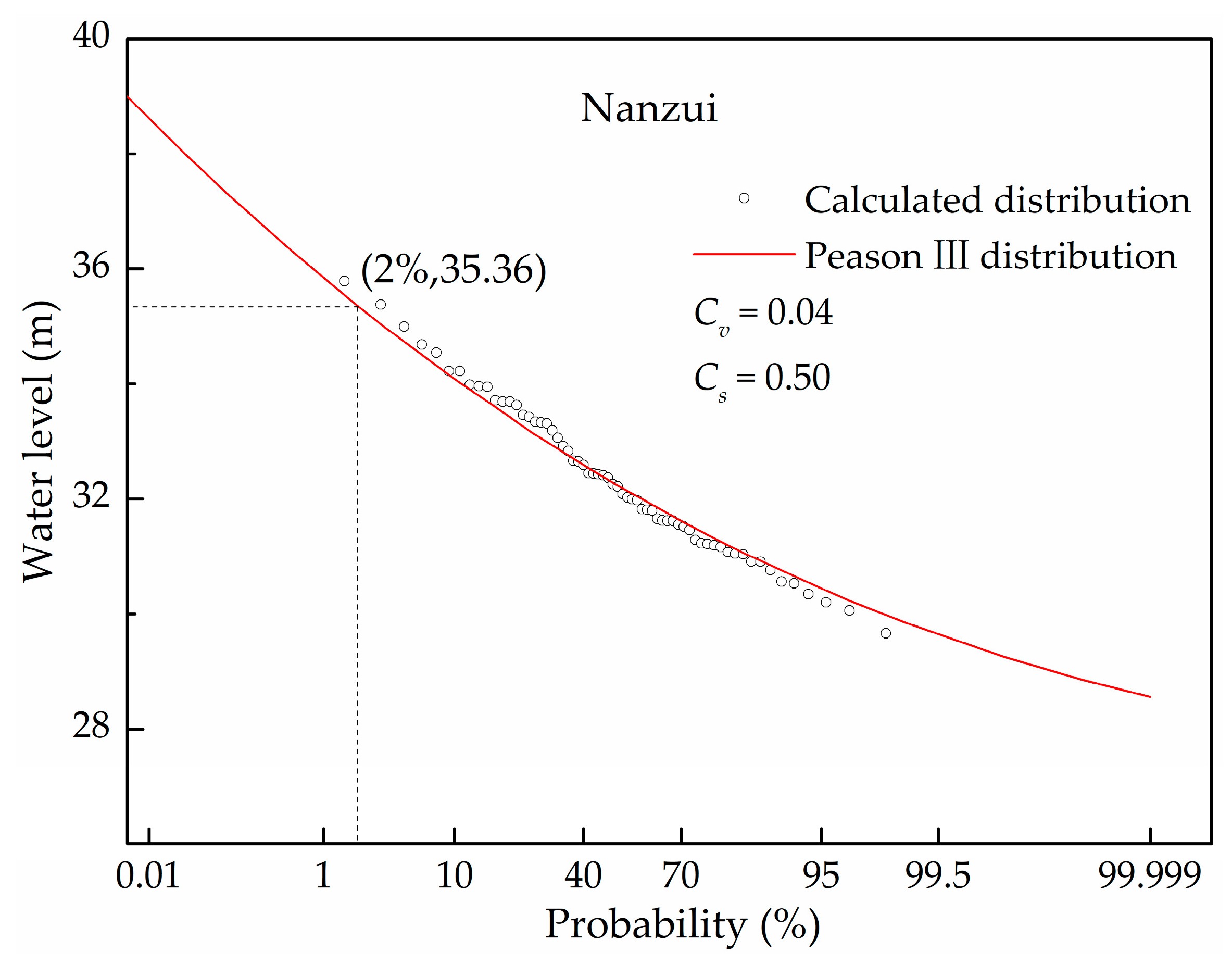
  • The numerical simulations agree reasonably with the observations overall with the NSE over 0.87, the maximum water level difference between the measured and simulated data is within 0.16 m at all selected stations, which indicates that the current MIKE 21FM model can dynamically simulate the flooding process in Dongting Lake.
  • The effective flood control capacity could be greatly increased by using the IFCS due to the fact that the safe floodwater (small/middle scale flood) is not allowed to enter the inner lake. Therefore, the effective flood control capacity increased by 4.7 times, 2.8 times, and two times during the first, second, and third flood wave, respectively, after the application of the IFCS in Dongting Lake for the 1998 type flood, which is one of the largest floods in the 20th century.
  • The operation of the IFCS plays a very important role in floodwater mitigation, which still needs further study to achieve the optimized water level reduction, especially in a complex system, which includes several gates in the flood control scheme (IFCS).
  • The IFCS also has great potential to increase the flood control capacity of the lake and thereby to mitigate the flood disaster in the flood-prone lake area according to the feasibility analysis for another large lake.

Author Contributions

Conceptualization, S.-Q.Y.; Formal analysis, Y.L. (Yizhuang Liu) and U.K.; Supervision, C.J., S.-Q.Y., and M.S.; Validation, Y.L. (Yuannan Long), B.D., and L.Y.; Writing—Original draft, Y.L. (Yizhuang Liu); Writing—Review & editing, S.-Q.Y., C.J., M.S., and K.E.

Funding

This research was funded by the China Scholarship Council, the National Natural Science Foundation of China (Grant No. 51839002) and the Natural Science Foundation of Hunan Province, China (Grant No. 2018JJ3535).

Acknowledgments

We would like to thank Dr. Ma Yuan and Yan Shixiong for providing the Figure 2.

Conflicts of Interest

The authors declare no conflict of interest.

References

  1. Berz, G. Flood disasters: Lessons from the past—Worries for the future. Proc. Ice Water Marit. Eng. 2000, 148, 57–58. [Google Scholar] [CrossRef]
  2. Lee, E.H.; Kim, J.H. Development of a flood-damage-based flood forecasting technique. J. Hydrol. 2018, 563, 181–194. [Google Scholar] [CrossRef]
  3. Kłosowski, G.; Rymarczyk, T.; Gola, A. Increasing the Reliability of Flood Embankments with Neural Imaging Method. Appl. Sci. 2018, 8, 1457. [Google Scholar] [CrossRef]
  4. Lugeri, N.; Kundzewicz, Z.W.; Genovese, E.; Hochrainer, S.; Radziejewski, M. River flood risk and adaptation in Europe—Assessment of the present status. Mitig. Adapt. Strateg. Glob. Chang. 2010, 15, 621–639. [Google Scholar] [CrossRef]
  5. Hayashi, S.; Murakami, S.; Xu, K.Q.; Masataka, W. Effect of the Three Gorges Dam Project on flood control in the Dongting Lake area, China, in a 1998-type flood. J. Hydro Environ. Res. 2008, 2, 148–163. [Google Scholar] [CrossRef]
  6. Rogers, R.A.; Schutten, J.K. The gender of water and the pleasure of alienation: A critical analysis of visiting Hoover Dam. Commun. Rev. 2004, 7, 259–283. [Google Scholar] [CrossRef]
  7. Van den Honert, R.C.; McAneney, J. The 2011 Brisbane Floods: Causes, Impacts and Implications. Water 2011, 3, 1149–1173. [Google Scholar] [CrossRef] [Green Version]
  8. Herdendorf, C.E. Large lakes of the world. J. Great Lakes Res. 1982, 8, 379–412. [Google Scholar] [CrossRef]
  9. Du, Y.; Xue, H.P.; Wu, S.J.; Ling, F.; Xiao, F.; Wei, X.H. Lake area changes in the middle Yangtze region of China over the 20th century. J. Environ. Manag. 2011, 92, 1248–1255. [Google Scholar] [CrossRef]
  10. Henny, C.; Meutia, A.A. Urban lakes in Megacity Jakarta: Risk and management plan for future sustainability. Procedia Environ. Sci. 2014, 20, 737–746. [Google Scholar] [CrossRef]
  11. Yang, S.Q.; Liu, P.W. Strategy of water pollution prevention in Taihu Lake and its effects analysis. J. Great Lakes Res. 2010, 36, 150–158. [Google Scholar] [CrossRef] [Green Version]
  12. Yang, S.Q. A Method to Increase the Flood Control Capacity in the Lake. China Patent CN03130017.0, 19 January 2005. [Google Scholar]
  13. Li, Y.; Yao, J. Estimation of Transport Trajectory and Residence Time in Large River–Lake Systems: Application to Poyang Lake (China) Using a Combined Model Approach. Water 2015, 7, 5203–5223. [Google Scholar] [CrossRef]
  14. Liu, H.; Deng, B.; Liu, Y.; Jiang, C.; Wu, Z.; Long, Y. Preliminary Numerical Analysis of the Efficiency of a Central Lake Reservoir in Enhancing the Flood and Drought Resistance of Dongting Lake. Water 2018, 10, 225. [Google Scholar] [CrossRef]
  15. Liu, H.; Jiang, C.; Yang, S.; Liu, Y.; Chen, J.; Long, Y.; Deng, B. A new lake treatment strategy for Dongting Lake based on central lake reservoir concept. Adv. Sci. Technol. Water Resour. 2018, 38, 19–25+31. (In Chinese) [Google Scholar]
  16. Haldar, R.; Khosa, R.; Gosain, A.K. Impact of Anthropogenic Interventions on the Vembanad Lake System. In Water Resources and Environmental Engineering I; Springer: Singapore, 2019; pp. 9–29. [Google Scholar]
  17. Yamashiki, Y.; Nakamura, T.; Kurosawa, M.; Matsui, S. Ecosystem approach to mitigate impacts of sedimentation on the hydrological cycle and aquatic ecosystem. Hydrol. Process. 2006, 20, 1273–1291. [Google Scholar] [CrossRef]
  18. Jiahu, J.; Xijun, L.; Qun, H. The characteristics of flood responses to the restoration of polders on Dongting Lake, China. Hydrol. Sci. J. 2007, 52, 671–685. [Google Scholar] [CrossRef]
  19. Nash, J.E.; Sutcliffe, J.V. River flow forecasting through conceptual model. J. Hydrol. 1970, 10, 282–290. [Google Scholar] [CrossRef]
  20. Lai, X.; Jiang, J.; Liang, Q.; Huang, Q. Large-scale hydrodynamic modeling of the middle Yangtze River Basin with complex river–lake interactions. J. Hydrol. 2013, 492, 228–243. [Google Scholar] [CrossRef]
  21. Gleick, P.H. Water in Crisis: Paths to Sustainable Water Use. Ecol. Appl. 1998, 8, 571–579. [Google Scholar] [CrossRef]
  22. Xu, Z.; Chen, M.; Dong, Z. Researches on the calculation methods of the lowest ecological water level of lake. Acta Ecol. Sin Ica 2004, 24, 2324–2328. (In Chinese) [Google Scholar]
  23. Water Resources Bureau of Hunan Province. Diversion, Migration and Construction in Dongting Lake in Hunan Province; WRBHP Report; Water Resources Bureau of Hunan Province: Hunan, China, 2002. (In Chinese) [Google Scholar]
  24. Arias, M.E.; Cochrane, T.A.; Piman, T.; Kummu, M.; Caruso, B.S.; Killeen, T.J. Quantifying changes in flooding and habitats in the Tonle Sap Lake (Cambodia) caused by water infrastructure development and climate change in the Mekong Basin. J. Environ. Manag. 2012, 112, 53–66. [Google Scholar] [CrossRef] [PubMed]
  25. Yu, W.; Kim, Y.; Lee, D.; Lee, G. Hydrological assessment of basin development scenarios: Impacts on the Tonle Sap Lake in Cambodia. Quat. Int. 2019, 503, 115–127. [Google Scholar] [CrossRef]
  26. Feng, L.; Hu, C.; Chen, X.; Cai, X.; Tian, L.; Gan, W. Assessment of inundation changes of Poyang Lake using MODIS observations between 2000 and 2010. Remote Sens. Environ. 2012, 121, 80–92. [Google Scholar] [CrossRef]
  27. Li, X.; Yao, J.; Li, Y.; Zhang, Q.; Xu, C.Y. A modeling study of the influences of Yangtze River and local catchment on the development of floods in Poyang Lake, China. Hydrol. Res. 2016, 47, 102–119. [Google Scholar] [CrossRef] [Green Version]
  28. Chen, J.; Duan, M.; Wu, P.; Sun, J. Study on the ecological water level of Poyang Lake with different time scales. Jiangxi Hydraul. Sci. Technol. 2018, 44, 160–168. (In Chinese) [Google Scholar]
Figure 1. Yangtze River basin.
Applsci 09 02465 g001
Figure 2. Location of Dongting Lake. The lake collects water from the Yangtze River through ‘three channels’ (Songzikou, Taipingkou, and Ouchikou) and ‘four rivers’ (Xiang, Zi, Yuan, and Li) and it discharges to the Yangtze River at Chenglingji.
Applsci 09 02465 g002
Figure 3. Comparison of water level process during the flood season (June to September) in 1998. (a) Nanzui; (b) Xiaohezui; (c) Xiangyin; (d) Yingtian; (e) Lujiao; and, (f) Chenglingji.
Applsci 09 02465 g003
Figure 4. The schematic of the innovative flood control scheme (IFCS).
Applsci 09 02465 g004
Figure 5. The application of the IFCS in Dongting Lake. (a) The layout of the IFCS; (b) The water body in the dry season of Dongting Lake (December 2006).
Applsci 09 02465 g005
Figure 6. The flooding process in Dongting Lake at selected stations in 1998.
Applsci 09 02465 g006
Figure 7. The water level process during the flood season (24 Jun. to 22 Sep. 1998) in Dongting Lake with and without IFCS. (a) Nanzui station; (b) Yingtian station; and, (c) Chenglingji station.
Applsci 09 02465 g007
Figure 8. The measured water level at Chenglingji station in 1996.
Applsci 09 02465 g008
Figure 9. The layout of the IFCS in East Dongting Lake.
Applsci 09 02465 g009
Figure 10. Simulation of fluctuation of water level at Chenglingji station.
Applsci 09 02465 g010
Figure 11. Water level distribution in Dongting Lake before the flood wave arrives in 1998. (a) 3 July; (b) 22 July; and, (c) 16 August.
Applsci 09 02465 g011
Figure 12. The schematic of the combined dike for IFCS. (a) The water block by the combined dike; (b) sections of the dike.
Applsci 09 02465 g012
Figure 13. The probability of the maximum water level at Nanzui stationby fiting Peason III distribution (1950–2014).
Applsci 09 02465 g013
Table 1. The Nash–Sutcliffe efficiency coefficients (NSE), R2 and the root mean square error (RMSE) calculated at the main hydrological stations in Dongting Lake.
StationsNSEMaximum Water Level (m)Difference (m)R2RMSE
MeasuredSimulated
Nanzui0.89035.3635.520.160.9280.478
Xiaohezui0.87335.1434.59−0.150.9290.484
Xiangyin0.93634.2834.370.090.9610.376
Yingtian 0.94934.2634.360.100.9670.363
Lujiao0.98634.1434.260.120.9920.239
Chenglingji0.98134.0033.98−0.020.9950.308
Table 2. The safe water level at each hydrological station (unit: m).
StationSafe Water LevelStationSafe Water LevelStationSafe Water Level
Nanzui34.20Xiangyin33.59Lujiao33.03
Xiaohezui33.85Yintian33.10Chenglingji32.50
Table 3. Comparison of effective flood control capacity before and after using the IFCS. WDL: West Dongting Lake; SDL: South Dongting Lake; EDL: East Dongting Lake.
Natural ConditionFirst Flood WaveSecond Flood WaveThird Flood Wave
Δh (m)Ve (109 m3)Δh (m)Ve (109 m3)Δh (m)Ve (109 m3)
WDL1.250.242.760.521.130.22
SDL0.870.491.770.990.840.47
EDL0.730.711.581.540.780.76
Total-1.44-3.05-1.45
IFCSΔh (m)Ve (109 m3)Δh (m)Ve (109 m3)Δh (m)Ve (109 m3)
WDL0.780.152.710.521.130.22
SDL0.540.301.480.830.840.47
EDL6.576.377.517.282.42.16
Total-6.82-8.65-2.85
Table 4. The difference between the peak water level before and after using IFCS at selected hydrology stations (unit: m).
StationSecond PeakThird Peak
Natural ConditionIFCSDifferenceNatural ConditionIFCSDifference
Nanzui35.6535.20−0.4535.3334.99−0.34
Xiaohezui34.7534.67−0.0834.8534.54−0.35
Yingtian34.1434.13−0.0134.5134.19−0.32
Lujiao33.9333.54−0.3934.2933.97−0.32
Chenglingji33.5433.12−0.4234.033.67−0.33
Table 5. The operating water level of the gate in East Dongting Lake (unit: m).
GateCase 1Case 2Case 3
#a33.10 *32.9032.70
#b32.50 *32.2032.00
*: the safe water level near the gate.

