Abstract
When a highway overlies a goaf, the cracking and subsidence of the highway subgrade seriously threaten the safe operation and maintenance of highways, including passenger safety. In this study, subgrade subsidence in the operation period of the G0611 Zhangye–Wenchuan Expressway from Biandukou to Menyuan was analyzed. First, the main factors influencing this kind of subsidence were analyzed using theoretical analysis, field investigation, and field detection. Then, an index system for these factors was constructed, composed of one target-layer, five criterion-layer, and seventeen indicator-layer indexes. The ANP and CRITIC methods were used to calculate the subjective and objective weights of each influencing factor index. The combined weights were obtained based on game theory, and the contribution degree of each index was determined. The primary and secondary relationships of the influencing factors of subgrade subsidence were inferred. The research results indicate that the foundation of the analyzed expressway section contains goaf areas, with poor filling performance, failure to fill in layers according to regulations, and poor drainage being the main reasons for subgrade subsidence. Based on the contribution degree of the indicator-layer influencing factors, high-energy-level dynamic compaction can be used to ram goafs so as to ensure the operational safety of the expressway.
1. Introduction
With the increasing traffic demand in China, highway construction is developing rapidly. At present, China’s operating highway mileage exceeds 184,000 km, and there is an intent to continue its expansion. With the extension of the operation time limit of the expressway, a series of quality-related problems, such as settlement, cracking, and collapse, have appeared in the subgrade, which poses a significant hidden danger for the safe operation and maintenance of the expressway [1]. As is widely known, the quality of highway subgrade directly affects the performance of highway engineering, project costs, and vehicle safety. In order to ensure the structural strength and stability of subgrade and pavement, it is necessary to strictly control their settlement and collapse during operation. Therefore, it is of great engineering significance to study the settlement evolution law and mechanism of highway subgrade overlies a goaf [2].
Many domestic scholars have systematically researched the settlement mechanism and its influencing factors through various technical means, such as field tests, model tests, numerical simulation, and theoretical analysis. Liu et al. [3] explored the internal relationship between the settlement evolution law of the overlying subgrade and parameters of the process of shield undercrossing; their analysis was based on the project of the double-line shield tunnel from Fengyiqiao South Station to Fengtai Station of Beijing Metro Line 16, which underpasses the existing railway line project. It was found that the torque of the shield cutter head, the jacking force, and the synchronous grouting amount have a significant influence on the settlement of the subgrade and pavement. Qian et al. [4] used FLAC 3D numerical simulation software to study the settlement law of high-speed railway subgrade under the influence of subway tunnel undercrossing construction; they focused on the influence of undercrossing angle on the pavement settlement trough and stratum slip curve and put forward a method for optimizing the subsidence angle based on the settlement law. Relevant research results have been applied in the sinking Wuhan–Guangzhou high-speed railway project for the tunnel between Guangzhou North Station and Huacheng Road Station in Guangdong, China.
Based on the Xianglushan Tunnel of the Central Yunnan Water Diversion Project, which crosses the G348 Shanghe Expressway project, Li et al. [5] combined field monitoring and numerical simulation methods, studied the evolution law of surface settlement and surrounding rock deformation during the construction of the subgrade of the shallow-buried tunnel underneath the expressway, and explored the influence of support strength and construction technology on the settlement and deformation. The results showed that, compared with strengthening the support parameters, improving the construction technology had a significantly greater effect on the settlement. Combined with indoor micro-testing and discrete element numerical simulation technology, Xiao et al. [6] studied microstructure characteristics and stress variation in collapsible loess caused by differences in loess porosity, analyzed the settlement law of collapsible loess subgrade in a highway reconstruction and expansion project, and explored the influence of different parameters on existing and reconstruction and expansion subgrade and pavement. The results showed that the settlement law of subgrade and pavement, both the existing structures and the reconstruction and expansion, is significantly affected by the width of the subgrade and the depth of cutting.
Tong et al. [7] discussed the interaction between the highway and the underlying goaf from three aspects: the mining response characteristics of the highway; the secondary activation mechanism of the goaf; and the surface movement and deformation law of the goaf under different working conditions, analyzed using finite element numerical analysis. Considering various influencing factors, such as the subgrade and pavement, the goaf, mining characteristics and treatment methods, deformation and failure characteristics, the secondary activation mechanism, and harmful influence, goaf formation via different mining methods was proposed. Ding et al. [8] used the GA-BP neural network model to analyze the influence of geological and mining conditions on the settlement of subgrade and pavement. The dip angle of the coal seam, the thickness of the loose layer, the comprehensive hardness of overburden, the average mining depth, the mining thickness, the advancing speed of the working face, the mining degree, and the tendency and strike lengths of the working face were taken as the input parameters of the model, and the probability integral prediction parameters were taken as the output parameters.
The results show that the network rapidly converges, with an average relative error of less than 3.0%, a data-fitting degree greater than 0.8, and a generalization performance index of more than 0.8, indicating that the model’s prediction accuracy is high and that it can meet the accuracy requirements for mining subsidence prediction with good prediction ability. Based on the Danxia Hub Interchange Expressway Project in Renhua County, Shaoguan City, Guangdong Province, Sun et al. [9] used the weight-of-evidence method to analyze the risk of karst collapse in subgrade and studied how the risk was affected by formation lithology, groundwater, roof thickness, and faults.
In addition, Shaer et al. [10] used a large-scale indoor similarity model test to study the cumulative settlement evolution law of subgrade under external dynamic load. Wang et al. [11] studied the horizontal, vertical, and differential settlement laws of new and existing high-speed subgrade by combining indoor testing, three-dimensional numerical analysis, and field measurement. The results show that in the construction stage of the new subgrade, the differential settlement of the subgrade increased rapidly to its maximum value. In the operation stage, the difference gradually decreased. However, existing research results mainly focus on the influence of subsidence construction in new projects or coal mine goafs on the settlement of the overlying subgrade and pavement, while few studies have examined how underlying historical gold mining structures affect the stability of the overlying highway subgrade and pavement.
Research has comprehensively identified key mechanisms governing expressway settlement. These include primary and secondary consolidation of soft soils, dynamic deformation under long-term traffic loading, and hydro-mechanical coupling effects due to groundwater fluctuation [12,13]. Particularly in goaf areas, sudden collapses induced by the progressive failure of underground cavities present a severe hazard. The interaction between these factors creates complex, nonlinear settlement patterns, making accurate prediction challenging [14,15]. Recent studies emphasize the coupled effects of these mechanisms, especially under extreme weather events and increasing heavy-duty traffic volumes [16]. In conclusion, future research is directed towards developing multi-physics coupled models, leveraging big data from multi-source monitoring, and creating intelligent prediction and early-warning systems capable of managing the complex settlement patterns of expressways throughout their lifecycle.
However, the existing research primarily focuses on the settlement development of overlying highway subgrades and pavements caused by the construction of new tunnels (for roads, railways, rail transit, coal mines, etc.), with limited studies on the stability of subgrades and pavements when new highways are built over historical goafs.
Therefore, in this study, the causative mechanism of the cracking and settlement of the subgrade of the G0611 Zhangwen Expressway section from Biandukou to Menyuan during the operation period was analyzed through field investigation and detection, as well as indoor testing. The causative mechanism was analyzed from the aspects of historical gold mining collapse, the highway drainage system, engineering construction quality, earthquake influence degree, and frost heave and thaw settlement of the underlying rock and soil. The relevant research results can provide a reference for treatment measures for similar engineering deficiencies in the future.
2. Project Overview and Disease Characteristics
2.1. Project Overview
The section from Biandukou to Menyuan, Qinghai Province, of the Zhangye–Wenchuan Highway G0611 was opened to traffic in July 2023. After this, the subgrade of the K63 + 180–K63 + 440 section showed obvious subsidence and wave fluctuation, which seriously affected the driving safety and normal operation. According to a site drilling survey (Figure 1), the stratum condition of the road section is relatively clear, and the stratum can be divided into the following three layers from top to bottom:
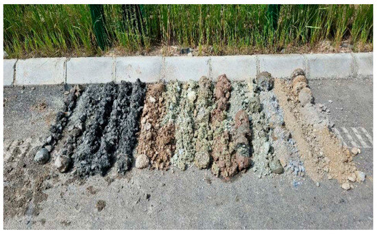
Figure 1.
Drilling core sample.
- The gravel soil layer is about 2 m thick.
- The mudstone and breccia soil layer is about 2~10 m in depth.
- The fully weathered, strongly weathered, and moderately weathered bedrock layers, comprising mainly siliceous mudstone and slate, are below about 10 m in depth.
Through the analysis of the relevant technical data, the basic condition of the Bianmen highway was determined, and the construction process of the road section was restored, as shown in Table 1 below.

Table 1.
Construction process of subgrade and pavement.
2.2. Disease Characteristics
Through data analysis, field detection, and investigation, the specific disease characteristics of the road section were determined as follows. These phenomena occurred from November 2023 to September 2024.
- Relatively few longitudinal and transverse cracks
According to the field investigation, there are only a few longitudinal and transverse cracks in the pavement in this section, as shown in Figure 2.
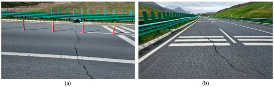
Figure 2.
Pavement cracks. (a) Transverse cracks in pavement. (b) Longitudinal cracks in pavement.
- 2.
- W-shaped vertical section settlement and obvious wave fluctuation
The longitudinal wave of the road surface obviously fluctuates, with a “W” shape. The shape of the anti-glare board is “accordion”-like, and the driving bump is clear, as shown in Figure 3.
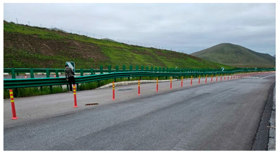
Figure 3.
Longitudinal wave fluctuation in road surface.
- 3.
- V-shaped cross-section settlement and large intermediate subsidence
The overall subsidence of the road section is shown in Figure 4. In general, the subsidence near the middle zone is relatively large, and that in the cross-section is “V”-shaped. As shown in Figure 5, the subsidence on the left is slightly larger than that on the right.
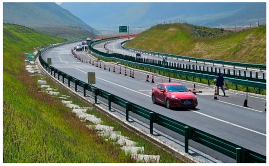
Figure 4.
Overall subsidence condition of the subgrade (that on the left is more obvious than that on the right).
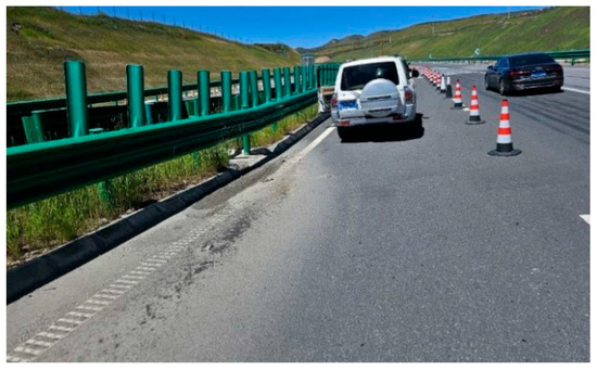
Figure 5.
Water has accumulated near the middle zone on the left.
- 4.
- Large subsidence
The field observation and measured data show that the maximum subsidence of the road section is 60–70 cm. The height of the side ditches of some sections is more than 60 cm, as shown in Figure 6.
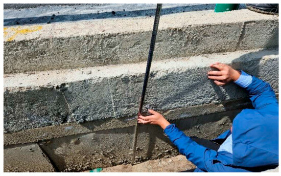
Figure 6.
Side ditch of more than 60 cm in height.
- 5.
- Fast subsiding velocity
The construction of the section’s subgrade started in May 2021 and was completed in November 2022. Paving was completed at the end of 2022, subgrade grouting treatment and surface milling and paving were carried out in May 2023, and the section was opened to traffic in July 2023. It has been open for more than one year; the subsidence has reached tens of centimeters, and its speed is fast.
3. Analysis of Influencing Factors
3.1. Goaf Collapse
According to the design and geological survey data, there are gold mining holes in this section. Gold mining began before liberation and stopped in 1985. The holes are about 1.5–2 m high and about 0.8–1.2 m wide, and other data are unknown. They are generally located above the bedrock. Through the analysis of the design, combined with the roadbed construction process, drilling, and subsidence excavation treatment, 5 collapsed holes were found in k63 + 000–k63 + 180 (2 holes from design, 2 holes from construction, and 1 hole from drilling), and 11 collapsed holes were found in k63 + 180–k63 + 440 (4 holes from design, 2 holes from construction, 1 hole from drilling, and 4 holes from excavation), as shown in Figure 7. The survey results show that the distribution range of the goaf in this section is wide, with a large number of collapsed holes. The regularity of the extension directions of the gold mining holes is not obvious, and their spatial positions are not clear.

Figure 7.
Excavation and collapsed hole of the right K63 + 305 roadbed.
3.2. Drainage Condition
- Rainfall
According to relevant data, the average annual rainfall in this geographical area is about 500 mm, and the average annual rainfall in this section is about 1/3 of this, that is, about 650 mm.
- 2.
- Surface drainage
The surface water on the left has a large catchment area. It flows into the pastoral road, through which some of it is discharged to both sides, and some of it infiltrates through the gravel soil to the right river through the foundation. The right cutting slope is a reverse slope, and the water on the cutting slope sinks into the right-side ditches.
- 3.
- Gutter drainage
The drainage of the side ditches mainly collects the water of the cutting slope and drains to both ends.
- 4.
- Blind ditch drainage under side ditches
According to the design, blind ditches are set under the side ditches and are 50 cm deep, but there are no outlets for them.
3.3. Construction Quality
The analysis of excavation strata determined that the colors and materials of the horizontal layer of the roadbed are inconsistent, indicating that it was not layered and compacted during its original construction (Figure 8). The top surface of the subgrade was treated with dynamic compaction, and the compaction energy was about 1500 kN·m. The subgrade’s construction began in 2021 and was completed in 2022. According to the excavation condition, the roadbed filler is gravel soil, and the lower filler contains disintegrating mudstone. The performance of the filler is poor, and layered filling was not carried out according to the specification.
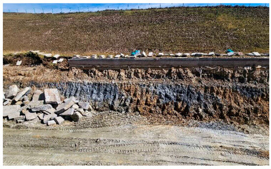
Figure 8.
Subgrade replacement status revealed by excavation.
3.4. Earthquake
On 8 January 2022, a 6.8-magnitude earthquake occurred in Menyuan, which was close to the epicenter, and then nearly 10 aftershocks with magnitudes of 3–4 occurred.
3.5. Frost Heave and Thawing Settlement
According to the investigation, there is no obvious frost heave cracking on the pavement of this section, so the probability of thaw settlement is not high. According to relevant data, the freezing depth in this area is about 2 m. The thickness of the pavement structure layer is about 70 cm, so after removing this, the frost depth of the subgrade is about 1.3 m. The filler in the range of the roadbed is mainly gravel soil, which is permeable.
4. Analysis of Causative Mechanism
4.1. Analysis Methods
First, the factors influencing the subgrade subsidence of the expressway were analyzed to construct an index system. Then, the ANP and CRITIC methods were used to calculate the weight of each influencing factor index, and their comprehensive weight was obtained based on game theory. Finally, the contribution degree of each influencing factor index was evaluated in order to further explore the mechanism through which it influences the process of subgrade subsidence, and the primary and secondary relationships between the influencing factors were inferred.
4.2. Index System of Subsidence Influencing Factors
The operational safety of expressway subgrade is affected by many factors. A scientific index system for these factors can serve as the basis for reasonable and accurate evaluation of the operational safety of subgrade and pavement. Too few influencing factors will lead to information loss, incomplete consideration of factors, and inaccurate evaluation results; too many factors will cause problems such as information overlap and cumbersome calculation, which will affect the results. Therefore, indicators should be selected following scientific, systematic, and independent principles [17]. Based on existing industry norms, the relevant literature, and field investigation [18,19], we constructed an index system of factors influencing the subgrade subsidence of the expressway, as shown in Table 2. We selected 17 indicators—including collapsed area, earthquake frequency, groundwater erosion, layered thickness, and surface drainage—under five key factors (goaf collapse, earthquakes, frost heave and redundant subsidence, construction quality, and drainage). The degree of influence was divided into four levels, and each level was quantitatively or qualitatively characterized according to the characteristics of the selected indicator-layer objects.
Table 2.
Index system of influencing factors of subgrade subsidence of expressway.
4.3. Comprehensive Weight of Influencing Factors of Subsidence
4.3.1. Calculation of Subjective Weight
On the basis of the AHP (Analytic Hierarchy Process) method, the ANP (Analytic Network Process) method adds the mutual influence relationship between indexes, which can reduce the weight gap between evaluation indexes brought by randomness and make the weight distribution more reasonable. However, this method involves uncertainty in the association rules of various indicators, which leads to excessive calculation. In order to solve this problem [20,21], the Apriori method was used in this study to preprocess the relationships between indicators. By analyzing an index correlation scheme given by many experts, unnecessary correlation factors were eliminated to simplify the ANP network structure. The steps of the Apriori method are as follows. The index association determined by n experts is defined as the data set {S}, and the index Bj (j = 1, 2, 3, …, m) contained in each connection data group is defined as an item. B is the item set of all the indexes in the data set {S}, and any subset of B contains K items. Let the support and confidence defined by subsets {P} and {Q} of B be
where σ(P) is the number of data sets {S} containing data group L; n is the number of data sets; and Support(PQ) is the probability of both {P} and {Q} being in the relational array.
Support(P) and Confidence (PQ) are defined. If the above two conditions are satisfied, {P} and {Q} are considered strong association rules. A relationship that does not satisfy the strong association rules is eliminated, and the association relationship is simplified.
Once the correlation between indicators has been simplified, the ANP method is used to calculate the subjective weight. The calculation steps of this method are as follows.
- Construction of judgment matrix
The judgment matrix is constructed under the control-layer criterion. After the consistency test, it is constructed into a local weight vector matrix, Wij.
- 2.
- The establishment of supermatrix
The local vector matrix of all elements is constructed in turn, and the supermatrix Ws, composed of the eigenvectors under the control criterion, is obtained.
- 3.
- The establishment of weighted supermatrix
Under the control-layer criterion, each element of the network layer compares the importance of B1, B2, …, BN to obtain a normalized sorting vector:
Then, the weighting matrix is obtained:
The supermatrix is weighted to obtain the weighted supermatrix.
- 4.
- Determination of subjective weights
By solving the limit of each weighted supermatrix, the subjective weight of the network-layer elements can be obtained by the following equation.
4.3.2. Calculation of Objective Weight
The CRITIC method is an objective weighting approach based on data volatility, which can effectively solve the problem of inaccurate evaluation caused by excessive fluctuation in index data due to uncertainty [22,23]. This method considers the variability and correlation of indicators at the same time, and the steps for calculating objective weight are as follows.
- Dimensionless processing
In order to eliminate the influence of different dimensions on the evaluation results, it is necessary to carry out dimensionless processing on each index. Equation (7) is used for the larger-the-better and the smaller-the-better indicators.
In the equation, xij is the value of the jth evaluation index of the ith sample; max(xij) and min(xij) are the maximum and minimum values of the jth evaluation index, respectively.
- 2.
- Calculation of the amount of information
In the equation, Cj is the information content of the jth index; xj is the mean value of the evaluation index; and rij is the correlation coefficient between i and j.
- 3.
- Calculation of weight
In the equation, Wj is the objective weight of the index j.
4.3.3. Combination of Weight Calculation
When determining the index weight, using the three-scale analytic hierarchy process alone is too subjective to calculate the index weight, and the calculation results are easily affected by personal preferences and lack certain objectivity. The entropy weight method only analyzes the changes in the data and is not affected by human factors, but it cannot consider the importance of the index itself. Sometimes the determined index weight will seriously deviate from the expected results. For more realistic and effective index weights, we use game theory to linearly combine the calculated subjective and objective weights so that the final index weight is more in line with the actual value. The specific process is as follows.
- Linear combination of weights
The index weight Us, calculated via the three-scale analytic hierarchy process, and the index weight Uo, obtained by the entropy weight method, are linearly combined to obtain the combined weight vector U. The expression is as follows:
In the equation, β1 and β2 represent the linear coefficients of subjective and objective weights, respectively.
- 2.
- Optimization of coefficient
Based on game theory, the linear combination coefficient in the following equation is optimized, and the Nash equilibrium point is obtained to meet the following conditions:
In the equation, Uq is the index vector weight calculated by the three-scale analytic hierarchy process and the entropy weight method.
- 3.
- Solve the linear coefficients β1 and β2
According to the differential properties of the matrix, the optimal first-order derivative of the above equation can be transformed into the following linear equation:
Through the above equation, β1 and β2 are obtained and normalized:
The combined weight vector obtained via game theory is
4.4. Analysis of Effect
The calculation results are shown in Figure 9. It can be seen from the figure that the combined weight determined based on game theory is between the combined weights determined by ANP analysis and CRITIC analysis. In the comprehensive multi-factor evaluation of expressway subgrade and pavement settlement, scientifically and reasonably determining the weights of various influencing factors is crucial for accurately diagnosing the causes of defects and proposing effective treatment solutions. Targeting the settlement issues in the Biandukou–Menyuan section of the G0611 Zhangye–Wuhan Expressway, this study innovatively introduces game theory to construct a combined weighting model that integrates the Analytic Network Process (ANP) and the Criteria Importance Through Intercriteria Correlation (CRITIC) method. This approach aims to overcome the limitations of single weighting methods, thereby more comprehensively and objectively revealing the contribution levels and intrinsic relationships of the influencing factors.
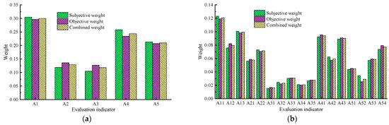
Figure 9.
The weights of influencing factors. (a) Indexes of the criterion layer. (b) Indexes of the indicator layer.
- Theoretical Basis and Construction Logic of Combined Weights
The combined weights determined in this study yield numerical results that notably fall between those derived from the ANP method and the CRITIC method. This outcome is not merely a simple compromise but an inevitable result of optimization and coordination based on game theory. The core idea behind applying game theory here is to treat different weighting methods as “players” in a decision-making process, seeking an optimal set of combined weights that best balance the interests of all parties—i.e., achieving the greatest consensus with the initial weights of each method.
Specifically, the ANP method focuses on the inherent attributes of the influencing factor indicators and the networked interactions among them. This method heavily relies on the knowledge and experiential judgment of domain experts, analyzing dependencies and feedback relationships between factors through the construction of judgment matrices. Consequently, the determination of weights incorporates a significant degree of expert subjectivity, effectively reflecting qualitative experiences and logical reasoning in engineering practice. However, its limitation lies in its relatively insufficient utilization of the objective information embedded in actual observational data. In stark contrast, the CRITIC method is a purely objective weighting approach. It relies entirely on the mathematical derivation of the internal data structure of the evaluation indicator matrix, determining the objective weights of indicators by calculating their contrast intensity (represented by standard deviation) and conflict (represented by correlation coefficients). An indicator with greater variability across samples (high contrast intensity) and lower correlation with other indicators (high conflict, i.e., providing independent information) will be assigned a higher weight. The advantage of the CRITIC method is that it entirely excludes human subjective bias, but its drawback is its inability to incorporate experts’ prior knowledge regarding the intrinsic importance of indicators.
Due to the fundamental differences in theoretical basis and data processing between the ANP and CRITIC methods, significant discrepancies in their judgments about the importance of certain influencing factor indicators are inevitable. For example, an indicator deemed critical by experts (high ANP weight) might exhibit little variation in observational data across road sections (potentially low CRITIC weight). Conversely, an indicator considered secondary by experts might display strong variability and independence in data (potentially high CRITIC weight). Relying solely on either method for calculating indicator weights fails to provide a comprehensive consideration of the influencing factors. It either over-relies on subjective experience while neglecting objective data patterns or depends entirely on data while losing engineering semantics, thereby leading to systematic deviations in the final comprehensive evaluation results from the optimal solution reflecting the actual situation.
The game theory-based combined weighting calculation method adopted in this study is precisely designed to bridge this gap. It places the “subjective importance” represented by the ANP method and the “objective information content” represented by the CRITIC method into a unified optimization framework for the game. Through mathematical modeling, it seeks a set of combined weighting coefficients that minimize the sum of squared deviations between the final comprehensive weight vector and the subjective weight vector of ANP and the objective weight vector of CRITIC. This process, on one hand, inherits and respects the inherent attributes and network relationships of the influencing factor indicators considered by the ANP method. On the other hand, it fully accommodates the intrinsic variation patterns and correlation structures among the data of influencing factor indicators revealed by the CRITIC method. Through this deep integration of subjective and objective information, the resulting weight calculations combine theoretical rationality with data adaptability, thus proving to be more accurate, reliable, and better aligned with engineering practice.
- 2.
- In-depth Analysis of Contribution Degrees of Influencing Factors and Identification of Primary Causes
Based on the calculation results of the aforementioned game theory combined weighting model, we conducted a thorough analysis of the contribution degrees of the influencing factors for the expressway subgrade and pavement settlement. The contribution degrees of the five criterion-level influencing factors, ranked in descending order, are as follows: goaf collapse A1 (0.2996), construction quality A4 (0.2436), drainage conditions A5 (0.2094), seismic activity A2 (0.1292), and frost heave and thaw settlement A3 (0.1182). This quantified ranking clearly reveals the relative importance of each factor in causing the settlement issues in this road section. It is particularly noteworthy that the weight value of the highest contributing factor, goaf collapse A1 (0.2996), is more than 2.5 times that of the lowest contributing factor, frost heave and thaw settlement A3 (0.1182). This significant difference in magnitude strongly indicates that goaf collapse is the most dominant and core causative factor for this road section.
Combined with detailed on-site engineering geological surveys and a review of construction records, we can draw a definitive conclusion: the primary causes of the subgrade settlement in this section can be attributed to the presence of underlying goafs formed by historical mining activities, which provided the fundamental geological condition for settlement. Simultaneously, the poor performance of the subgrade filling materials and the failure to strictly adhere to the technical specifications for highway subgrade construction regarding layered filling and adequate compaction (construction quality A4, the second-highest contributor) resulted in insufficient strength and increased compressibility of the subgrade itself. Furthermore, the inadequate surface and subsurface drainage systems of the subgrade (drainage condition A5, the third highest contributor) allowed rainwater infiltration, softening the soil and weakening the foundation, which further exacerbated the occurrence and development of differential settlement. These three primary factors are interconnected and mutually reinforcing, collectively dominating the settlement issues in this road section.
- 3.
- Detailed Deconstruction of Goaf Disaster Mechanisms and Precise Treatment Strategies
To provide a more targeted theoretical basis for the treatment plan, we further conducted an in-depth deconstruction of the indicator-level factors under the criterion layer of “goaf collapse A1,” which has the highest contribution degree. The contribution degrees of its three subordinate indicators are as follows: number of collapse cavities A11 (0.121), spatial distribution of collapse cavities A13 (0.0992), and area of collapse cavities A12 (0.0796). This ranking carries profound engineering implications:
Number of Collapse Cavities A11 (Highest Contribution): Directly reflects the “numerous and widespread” nature of goaf collapse hazards. A greater number of collapse cavities implies more potential instability points beneath the subgrade, significantly increasing the risk of coordinated settlement or sudden collapse.
Spatial Distribution of Collapse Cavities A13: Describes the spatial arrangement pattern of the collapse cavities. Disordered, dense, or uneven distributions, especially when located beneath critical stress-bearing areas of the subgrade, readily cause stress concentration, leading to differential settlement and longitudinal cracks in the subgrade.
Area of Collapse Cavities A12: Although the area of a single collapse cavity affects local stability, its overall contribution in this study is relatively lower than that of the number and distribution factors. This may suggest that the goafs in this area are predominantly composed of small- to medium-sized collapse cavity groups, where the cumulative effect of their numbers and unfavorable distribution patterns poses a greater threat.
Based on this refined understanding of the contribution degrees at the indicator level, traditional solutions such as grout filling may face challenges, including high costs, low construction efficiency, and difficulty in ensuring filling effectiveness, due to the “wide distribution and unclear spatial locations” of the goafs. Therefore, this study recommends the use of high-energy dynamic compaction technology to proactively implement “collapse-inducing treatment” on the goafs. The advantages of this technique lie in utilizing immense impact energy to actively and forcibly collapse the roof strata of shallow-buried goafs with weak roof lithology. Subsequently, high-quality fill material is placed in the compaction craters, or the collapsed material is compacted in situ, forming a dense “hard shell” foundation from bottom to top. This method effectively eliminates underground voids and weak zones, transforming the unstable goaf foundation into a composite foundation with strong integrity and high bearing capacity. Thereby, it fundamentally overcomes the difficulties of unclear spatial locations and extensive treatment areas of the goafs, laying a solid foundation for the long-term operational safety of the expressway.
In summary, through the game theory-based combined weighting model, this study not only scientifically quantified the contribution degrees of various influencing factors and accurately identified the primary causes of the defects but also, via in-depth analysis at the indicator level, provided direct and powerful decision-making support for selecting the most economical and effective engineering treatment measures. This demonstrates the significant value of closely integrating theoretical analysis with engineering practice.
5. Conclusions
To elucidate the causative mechanism of roadbed and pavement subsidence on expressways, this study analyzed the cracking and settlement of the roadbed and pavement of the G0611 Zhangwen Expressway section from Biandukou to Menyuan during its operation period. As a result, a novel index system of influencing factors is proposed to analyze the subsidence mechanism and the contribution of its influencing factors. The main conclusions are as follows:
- By integrating theoretical analysis, field surveys, and on-site inspections, the primary factors contributing to the settlement in this section were identified. These include goaf collapse, drainage conditions, construction quality, seismic activity, and frost heave with thaw-induced settlement.
- A comprehensive indicator system for evaluating influencing factors of expressway subgrade settlement was established. This system comprises one objective-layer, five criterion-layer, and seventeen indicator-layer indexes, providing a structured framework for systematic analysis.
- The Analytic Network Process (ANP) and Criteria Importance Through Intercriteria Correlation (CRITIC) methods were employed to calculate the subjective and objective weights of each influencing factor, respectively. Based on game theory, combined weights of the indicators were derived to achieve a balanced evaluation. The results demonstrate that the criterion-layer indicators—goaf collapse, construction quality, and drainage conditions—are the primary contributors to subgrade settlement. Specifically, the settlement in this section is mainly attributed to the presence of goafs in the foundation, poor performance of fill materials, non-compliant layered filling practices, and inadequate drainage. Given the extensive distribution and uncertain spatial positioning of the goafs in this area, high-energy dynamic compaction is recommended as an effective measure to collapse the goafs, thereby ensuring the operational safety of the expressway.
- This study provides both theoretical insights and practical solutions for addressing settlement issues in expressways overlying goaf areas, with significant implications for infrastructure maintenance and hazard mitigation.
Author Contributions
Conceptualization, C.R. and C.S.; methodology, L.W.; formal analysis, P.L.; data curation, P.L.; writing—original draft preparation, C.R.; supervision, C.S. and J.D.; writing—review and editing, J.D.; project administration, L.W.; funding acquisition, L.W. All authors have read and agreed to the published version of the manuscript.
Funding
This research was funded by the Basic Research Business Expenses for Central Level Public Welfare Research Institutes, grant number (0125KY03011061).
Institutional Review Board Statement
Not applicable.
Informed Consent Statement
Not applicable.
Data Availability Statement
The original contributions presented in the study are included in the article; further inquiries can be directed to the corresponding author.
Acknowledgments
We would like to thank the anonymous reviewers for their valuable comments and suggestions for improving this paper. In addition, I would like to express my gratitude to Fei Huang, Jinkun Yang, and Zhijie Han for their assistance with this thesis, including resources, validation, and investigation.
Conflicts of Interest
The authors declare no conflicts of interest.
References
- Huang, X.J.; Liu, W.Z.; Guo, Q.; Tan, J.M. Prediction method for the dynamic response of expressway lateritic soil subgrades on the basis of Bayesian optimization CatBoost. Soil Dyn. Earthq. Eng. 2024, 186, 108943. [Google Scholar] [CrossRef]
- Zhang, Z.; Wang, Q.Z.; Zhang, K.; Fang, J.H.; Li, S.; Ge, A.Y.; Huang, H. Study on the physical and mechanical properties of recycled weathered rock materials in expressway subgrade in permafrost areas. Constr. Build. Mater. 2024, 430, 136494. [Google Scholar] [CrossRef]
- Liu, X.; Zhang, R.; Fang, Q.; Li, Q.Q.; Jiang, A.N.; Li, K.C. Subgrade settlements of existing railway lines and operational parameters of shield machine induced by twin shield tunnel excavations: A case study. J. Cent. South Univ. 2024, 31, 272–287. [Google Scholar] [CrossRef]
- Qian, W.P.; Qi, T.Y.; Zhao, Y.J.; Le, Y.Z.; Yi, H.Y. Deformation characteristics and safety assessment of a high-speed railway induced by undercutting metro tunnel excavation. J. Rock Mech. Geotech. 2019, 11, 88–98. [Google Scholar] [CrossRef]
- Li, J.H.; Xu, R.; Gao, T.; Ou, Y.L.; Yang, Z.J. Settlement control of highway roadbed under shallow tunnel underpass construction conditions. J. Tsinghua Univ. (Sci. Technol.) 2024, 64, 1252–1263. [Google Scholar] [CrossRef]
- Xiao, W.B.; Li, J.; Wu, K.; Wang, Z.Q.; Xu, W.B.; Liu, D.P.; Zhang, Z.Q.; Shen, P. Micromechanical characteristics of collapsible loess and its subgrade settlement law. J. Shandong Univ. (Eng. Sci.) 2024, 54, 163–173. [Google Scholar] [CrossRef]
- Tong, L.Y.; Qiu, Y.; Liu, S.; Fang, L. Discussion of interaction law of expressway and underlying mine goafs. Chin. J. Rock Mech. Eng. 2010, 29, 2271–2276. [Google Scholar]
- Ding, Y.; Deng, N.D.; Yao, T.; Liu, D.H.; Shang, H. Prediction of railway subgrade subsidence based on geological mining conditions. Coal Sci. Technol. 2022, 50, 135–145. [Google Scholar]
- Sun, L.; Ren, N.N.; Li, Y.A.; Hu, L.J. Risk assessment on karst collapse of the highway subgrade based on weights of evidence method. Chin. J. Geol. Hazard Control 2019, 30, 94–100. [Google Scholar]
- Shaer, A.; Duhamel, D.; Sab, K.; Foret, G.; Schmitt, L. Experimental settlement and dynamic behavior of a portion of ballasted railway track under high speed trains. J. Sound Vib. 2008, 316, 211–233. [Google Scholar] [CrossRef]
- Wang, C.J.; Xie, L.F.; Liu, Z.M.; Wu, M.; Zhang, T.; Cai, G.J.; Liu, S.Y. Study on settlement deformation law of new and old subgrade of expressway reconstruction and expansion based on CPTU. Transp. Geotech. 2024, 49, 101392. [Google Scholar] [CrossRef]
- Indraratna, B.; Sun, Q.; Heitor, A. Performance of ballasted tracks on soft soil improved by prefabricated vertical drains: A case study. Geotechnique 2021, 71, 441–456. [Google Scholar]
- Liu, S.Y.; Du, G.Y.; Wang, Z.B. A novel approach for predicting soft soil settlement using a combination of finite element analysis and machine learning. Comput. Geotech. 2020, 122, 103497. [Google Scholar]
- Qin, Y.; Zhang, Z.; Xue, Y.G. Monitoring and analysis of highway deformation in mining area using SBAS-InSAR and GIS: A case study. IEEE J. Sel. Top. Appl. Earth Obs. Remote Sens. 2022, 15, 2852–2865. [Google Scholar]
- Sun, L.; Chen, J. Predicting long-term settlement of soft soil subgrade under traffic loading using LSTM neural network. Transp. Geotech. 2021, 28, 100534. [Google Scholar]
- Wang, F.M.; Zhang, X.; Wang, L. Field monitoring and numerical analysis of expressway settlement over a mined-out area stabilized with grouting. Int. J. Rock Mech. Min. Sci. 2020, 128, 104271. [Google Scholar]
- Xie, Y.C.; Wang, L.; Sun, D.A.; Zhang, L.; Liu, C.X.; Xu, Y.F. Health diagnosis model with combination weight and clustering method for protection works of expansive soil slope and its application. J. Cent. South Univ. (Sci. Technol.) 2022, 53, 258–268. [Google Scholar]
- Ministry of Transport of the People’s Republic of China. Technical Standard of Highway Engineering; China Communications Press: Beijing, China, 2014.
- Ministry of Transport of the People’s Republic of China. Design Specification for Highway Alignment; China Communications Press: Beijing, China, 2017.
- Kan, Z.; Wei, Y.M.; Zhao, T.Y.; Cao, J.T. Risk evaluation of submarine pipelines in FMEA by combination of grayrelation projection and VIKOR method. Ocean Eng. 2024, 302, 117695. [Google Scholar] [CrossRef]
- Li, X.Z.; Zhang, P.X.; He, Z.C.; Huang, Z.; Cheng, M.L.; Guo, L. Identification of geological structure which induced heavy water and mud inrush in tunnel excavation: A case study on Lingjiao tunnel. Tunn. Undergr. Space Technol. 2017, 69, 203–208. [Google Scholar] [CrossRef]
- Liu, N.; Pei, J.H.; Cao, C.Y.; Liu, X.Y.; Huang, Y.X.; Mei, G.X. Geological investigation and treatment measures against water inrush hazard in karst tunnels: A case study in Guiyang, southwest China. Tunn. Undergr. Space Technol. 2022, 124, 104491. [Google Scholar] [CrossRef]
- Su, R.; Su, Q.; Dong, M.Q.; He, C.F.; Zheng, Y.C.; Wang, X.; Pei, Y.F. Centrifugal model test study on deformation characteristics of deep, thick fillings in giant karst cave tunnels under different construction processes. Transp. Geotech. 2023, 42, 101068. [Google Scholar] [CrossRef]


Disclaimer/Publisher’s Note: The statements, opinions and data contained in all publications are solely those of the individual author(s) and contributor(s) and not of MDPI and/or the editor(s). MDPI and/or the editor(s) disclaim responsibility for any injury to people or property resulting from any ideas, methods, instructions or products referred to in the content. |
© 2025 by the authors. Licensee MDPI, Basel, Switzerland. This article is an open access article distributed under the terms and conditions of the Creative Commons Attribution (CC BY) license (https://creativecommons.org/licenses/by/4.0/).