Abstract
This study investigated literature databases of Google Scholar and Scopus from 1900 to 2021 and reviewed relevant studies conducted to increase transportation infrastructure resilience to flood events. This review has three objectives: (1) determine which natural hazard or natural disaster had the most vulnerability studies; (2) identify which infrastructure type was most prevalent in studies related to flood resilience infrastructure; and (3) investigate the current stage of research. This review was conducted with three stages. Based on stage one, floods have been extremely present in research from 1981 to 2021. Based on stage two, transportation infrastructure was most studied in studies related to flood resilience. Based on stage three, this systematic review focused on a total of 133 peer-reviewed, journal articles written in English. In stage three, six research categories were identified: (1) flood risk analysis; (2) implementation of real-time flood forecasting and prediction; (3) investigation of flood impacts on transportation infrastructure; (4) vulnerability analysis of transportation infrastructure; (5) response and preparatory measures towards flood events; and (6) several other studies that could be related to transportation infrastructure resilience to flood events. Current stage of studies for increasing transportation resilience to flood events was investigated within these six categories. Current stage of studies shows efforts to advance modeling systems, improve data collections and analysis (e.g., real-time data collections, imagery analysis), enhance methodologies to assess vulnerabilities, and more.
1. Introduction
A natural disaster is an actual event that causes detrimental effects while a natural hazard is the threat of an event that could cause a detrimental effect [1]. Natural disasters are created by shifts in the Earth’s general stability—whether it is movement of plates in the Earth’s crust to form an earthquake, excess rain that cannot fully infiltrate into the ground, or extremely dry areas catching fire from the heat. These often create secondary events, such as landslides or mudslides, as a result of a flooding event. While these events are not able to be restrained, it is possible to lessen the impacts and prepare as best as possible [2]. Natural disasters negatively affect people’s lives as they can be fatal, economically devastating, and environmentally depleting. This loss of life, damage to important infrastructure, and loss of resources all creates life-changing impacts that are physically, socially, economically, and environmentally damaging. Physical impacts can include damage or contamination to property, built infrastructure, and land. This results in injury, death, and loss of people, structures, animals, and crops [3]. Social impacts can be physical and/or mental health effects or destruction of household structures [3]. Economic losses are interconnected with physical impacts as well, and can be represented by costs associated with repair, replacement, and recovery [3]. Negative environmental impacts are also caused by natural disasters; for example, droughts alter water availability which causes biodiversity crises [4].
Vulnerability connects natural disaster events and the level of their risk by describing the degree that the afflicted places or people may be negatively impacted [5]. There are innumerous classification systems and methods of categorizing natural hazards and natural disasters for different areas of the world and from different sources. The most significant natural hazards and natural disasters of which to investigate vulnerability using lists and indexes by the Center for Disease Control and Protection [6], United States Geological Survey [7], Center for Disease Philanthropy [8], and Federal Emergency Management Agency [1] include, but are not limited to: avalanche, drought, earthquake, extreme temperature, flood, hail, heat wave, hurricane, ice storm, landslide, lightning, strong wind, tornado, tsunami, wildfire, winter weather, and volcanic activity.
Resilience represents the response to and the ability to recoup losses and recover stability after a natural disaster [5]. The Environmental Protection Agency (EPA) stated that focus on preparedness and recovery aligned with smart growth methods can help with a community’s response to natural disasters [9]. Resilience, therefore, does not only represent the reaction post-natural disaster, but is largely affected by the awareness and preparedness of a community to their vulnerability to the natural disaster in the first place. The Department for International Development (DFID) stated that overall resilience includes adaptation of livelihoods and infrastructure, anticipation of vulnerability in climate and extreme scenarios, absorption of the effects and response for recovery, and response when the actual events occur [10]. Resilience begins with awareness and protective measures for infrastructure and concludes with disaster response.
Infrastructure is an important part towards the functioning of society, thus improving and maintaining infrastructure in a way that is resilient is important. A process of planning and assessing the vulnerability, designing reasonable resilience actions, implementing these actions in the area, and consistently reviewing and adapting is best advised. Some examples of proactive changes as resilience efforts are green roofs to combat extreme heat in cities or wetlands to help with coastal flooding along shorelines [11].
This review focused on the vulnerability and resilience related to natural disaster events, specifically involving infrastructure that is important to the function of society during and after a natural disaster. For investigating most relevant studies, three stages of the review process were conducted, as seen in Figure 1. The first two stages were to tailor and find the most pertinent studies. Stage one revealed that flooding was the most pertinent natural disaster to investigate based on studies related to types of natural hazard and natural disaster vulnerability. Stage two determined transportation as the most critical infrastructure type in relation to flood resilience. Stage three determined keywords based on the examination of abstracts and titles of relevant studies, and then the final keywords were used to select studies most related to transportation infrastructure resilience to flood events, as directed by stages one and two. The final studies selected were reviewed. These stages are further explained and delineated in the section of Materials and Methods.
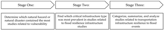
Figure 1.
Methodological Framework of this Systematic Review.
The following questions were addressed through this review considering the results of the searches of recent research:
- (1)
- Which natural disaster is most pertinent for vulnerability study?
- (2)
- Which aspect of infrastructure should be included in flood resilience study?
- (3)
- What is the current stage of research related to transportation infrastructure resilience to flood events?
2. Materials and Methods
This review utilized Google Scholar and Scopus to search for scholarly articles and papers published from 1900 to 2021. Google Scholar searches scholarly literature from articles, theses, and books from multiple publishers, societies, and repositories. It was chosen as a widely used starting ground for scientific research [12]. Scopus is a database of peer-reviewed literature that is collected from journals, books, and conferences regarding science, technology, social sciences, arts, and humanities. It was chosen as it represents a main data source for over three thousand academic and corporate institutions [13]. The results found from these searches were very widespread from a variety of major journals, databases, and websites including: SpringerLink, ASCE, MDPI, Sage Journals, ScienceDirect, and Wiley Online Library. Result totals mentioned below are equivalent to the sum of both database searches’ results together. An advanced search was used by one independent reviewer with the criteria of: (1) custom range in the beginning of the review from 1900 to 2021 for Google Scholar and 1961 to 2021 for Scopus since Scopus does not provide data from 1900 to 1960, (2) exclusion of citations and patents results in Google Scholar, and (3) search keywords in the title of the article in both Scopus and Google Scholar. Citations and patents were excluded as these represented sources without publication access and patents were not the format represented in studies for this review. The search criteria within Scopus were limited to article title and within Google Scholar to title only to exclude results of which the topic was not the primary focus. A variety of publications were accepted including articles, journal papers, reports, and theses until the third stage in which only peer-reviewed journal publications in English were considered. As aforementioned, this review contained three stages. Each stage’s key features can be seen in Figure 2 and each is explained in greater detail below.
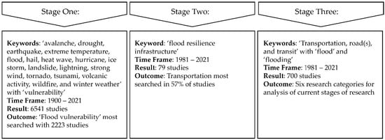
Figure 2.
Detailed Framework of this Systematic Review.
As mentioned previously, this review initiated with a search to find which natural hazard or natural disaster was most studied regarding vulnerability. Stage one conducted a search with seventeen natural hazards and natural disasters as mentioned above, and the word ‘vulnerability,’ since vulnerability refers to a possible level of destruction due to a natural disaster. Table 1 presents the number of studies found with each type of natural hazard or natural disaster; a total number of 6541 results were found from all natural disaster vulnerability studies. As seen in Table 1, the amount of studies related to natural hazard and natural disaster vulnerability was nearly zero from 1900 to 1980, but it began to increase from 1981 to 1990. This can be likely attributed to two factors: the increase of occurrence of several natural disasters and efforts to prepare and respond to natural disasters, such as the development of corporations that initiated extensive amounts of studies [14]. Since the 1980’s, large corporations including the Centre for Research on the Epidemiology of Disasters (CRED) and the US Agency for International Development (USAID) initiated efforts to investigate natural disasters [14]. These two factors could be linked with climate change, as the early 1980’s felt increased temperature and the late 1980’s experienced drought and wildfire, and the Intergovernmental Panel on Climate Change was formed in 1989 [15].

Table 1.
Natural Hazard and Natural Disaster Vulnerability Study Results over Time from both Google Scholar and Scopus.
As seen in Table 1, ‘flood vulnerability’ was the most prominent with 2223 results, which confirmed this as the most decisive direction to conduct the rest of the review. The next highest was ‘drought vulnerability’ with 1383 results, and all others had lower result totals. Since studies regarding the vulnerability of floods represented the natural disaster with the highest amount of studies from a total of seventeen natural hazard and natural disaster vulnerability searches, flood was chosen as the natural disaster to further investigate. Figure 3 presents a similar trend as all natural hazards and natural disasters observed; flood vulnerability studies also increased rapidly after the 1980′s. Therefore, the authors further focused on the time frame of database from 1981 to 2021 to conduct the remainder of this review.
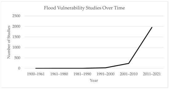
Figure 3.
Flood Vulnerability Study Results over Time from both Google Scholar and Scopus.
With stage two, this review persisted to find which infrastructure was most studied with flood resilience. Resilience is one of the key aspects to consider with floods since it accommodates proper management of floodwater during flooding events which lessen risk to people and infrastructure [16]. Increasing resilience is crucial to ensure the well-being of communities that are affected by flood events, and infrastructure is a component that affects resiliency of the communities. To influence resilience of communities, infrastructure handles, withstands, and restores operability to floods and thus requires alterations, changes, and proper development to handle these events. Since climate change has increased the intensity and frequencies of floods, infrastructure resilience is a high priority. This study considered critical infrastructure including the chemical, commercial facilities, communications, critical manufacturing, dams, defense industrial base, emergency services, energy, financial services, food and agriculture, government facilities, healthcare and public health, information technology, nuclear, transportation, and water and wastewater systems sectors [17].
Stage two used the keyword phrase ‘flood resilience infrastructure.’ Results from the search keyword phrase ‘flood resilience infrastructure’ totaled to 79 results. 55 results were considered since 24 results were repeated between the two databases. Each study was screened, and these 55 studies were categorized by the primary types of critical infrastructure which were involved in the study: transportation, wastewater treatment, water supply, energy, green infrastructure, health care, housing, communications, and emergency services. Transportation was focused on in 57% of these studies, wastewater treatment in 42%, energy in 34%, water supply in 32%, green infrastructure in 23%, health care in 21%, communications in 21%, housing in 19%, and emergency services in 8%. Many articles featured more than one type of infrastructure, so total percentages are not one hundred. Since transportation was the most prevalent infrastructure type, this was considered in relation to floods and resilience studies for the rest of the review.
In stage three, this study searched literature related to transportation infrastructure resilience to flood events. Based on titles and abstracts, final keywords (i.e., ‘transportation’, ‘road(s)’, and ‘transit’ with ‘flood’ and ‘flooding’) were determined. Authors included ‘flood’ and ‘flooding’ in keywords since these terminologies have slightly different definitions, and either is commonly used in studies of transportation infrastructure resilience to flood events. Flood is the natural disaster itself while flooding is the act of the natural disaster occurring. Furthermore, an option used by the authors within Google Scholar to search relevant studies was including the exact keywords in the title of the article. By using keyword combinations with ‘flood’ and ‘flooding’, the authors included all relevant studies. The searches yielded a total of 700 studies: 475 studies with ‘flood’ and 236 studies with ‘flooding.’ ‘Road’ and ‘roads’ were used for the same reason with Google Scholar.
This review then checked these 700 studies and excluded 566 studies. The accepted studies for this third stage were: (1) written in English and (2) peer-reviewed published journal publications with available access. Conference proceedings, books, reports, or academic papers (i.e., thesis or dissertation) were not included. Irrelevant studies (e.g., habitat modification due to road-killed snakes caused by summer flooding) were also excluded. Therefore, a total of 133 studies were further investigated.
Based on reviewing abstracts of these 133 studies, this study first determined six main research categories as they relate to transportation infrastructure resilience to flood events. These studies were categorized as aligned with the Infrastructure Resilience Planning Framework (IRPF) established by the Cybersecurity and Infrastructure Security Agency (CISA), as seen in Figure 4. The IRPF consisted of 5 total steps: (1) Lay the Foundation; (2) Critical Infrastructure Identification; (3) Risk Assessment; (4) Develop Actions; and (5) Implement and Evaluate. This framework supported the Federal Management Agency (FEMA) National Mitigation Investment Strategy and the U.S. Government Accountability Office (GAO) Disaster Resilience Framework. Therefore, this framework is applicable to any of the sixteen critical infrastructure types, including transportation infrastructure [18].
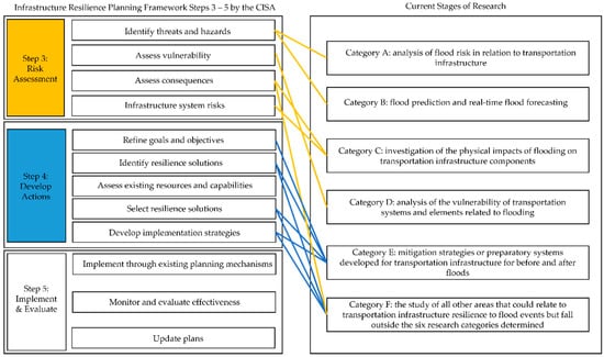
Figure 4.
Category Association with the Infrastructure Resilience Planning Framework.
This framework is a flexible guidance to help lay the groundwork for success, prioritize critical infrastructure, understand risk, identify opportunities to improve resilience, and influence decision-making related to resilience for planning and investment decisions. Since this framework expressed this flexibility with its use, the first two steps were covered by the first two stages of this review as transportation infrastructure was determined as the main area for stage three.
Research category A: analysis of flood risk in relation to transportation infrastructure. Recognition of flood risk is imperative to help future planning and investment decisions related to resiliency of transportation infrastructure [19].
Research category B: flood prediction and real-time flood forecasting. According to Fan, C., et al. (2020), accurate flood forecasting would increase transportation resiliency that allows emergency managers, public officials, and other decision-makers to have more accurate and real-time flood prediction data [20].
Research category C: investigation of the physical impacts of flooding on transportation infrastructure components. The World Economic Forum (2015) noted that proper assessment, understanding, and explanation of the existing risks of flooding is beneficial to heighten resilience to floods. For a proper response method to be established for floods, the problem itself must first be identified [21].
Research category D: analysis of the vulnerability of transportation systems and elements related to flooding. As stated by Colon, C., et al. (2020), transport systems hold high vulnerabilities and are important before and after flooding events. By evaluating vulnerability of components of the transport network, prioritization of resilience efforts can be made to benefit economics and general function [22].
Research category E: mitigation strategies or preparatory systems developed for transportation infrastructure for before and after flood events. As Gersonius, B., et al. (2016) noted, resilience strategies utilize prevention and preparedness measures to reduce effects and risks of flooding [23]. Improving effectiveness of design standards for more resilient transportation infrastructure, disaster recovery plans, and consideration of better planning measures for redundancy and flexibility of transportation infrastructure is critical to improve [19,24,25].
Research category F: the study of all other areas that could relate to transportation infrastructure resilience to flood events but fall outside the six research categories determined.
As discussed above, six research categories were aligned with Steps 3 and 4 of the IRPF. Categories A and B worked for identifying threats and hazards. Category C applied to assess consequences and infrastructure system risks. Category D represented assess vulnerability. Category E worked for refining goals and objectives, identifying and selecting resilience solutions, and developing implementation strategies. Category F applied to assess consequences, identify resilience solutions, select resilience solutions, and develop implementation strategies. There is a research gap for assessing existing resources and capabilities, implementing through existing planning mechanisms, monitoring and evaluating effectiveness, and updating plans. This is discussed in greater detail in the Discussion section. This final stage of the review investigated 133 studies, which consist of 17 studies in Category A, 11 studies in Category B, 29 studies in Category C, 25 studies in Category D, 20 studies in Category E, and 31 studies in Category F.
3. Results
As aforementioned in the Materials and Methods section, a final 133 studies were investigated to review the studies conducted to increase transportation infrastructure resilience to flood events. Table 2, Table 3, Table 4, Table 5, Table 6 and Table 7 present these 133 studies including the title, year of publication, authors, country of study area conducted, and the journal published within for each category. All studies are listed in a publication year order. In case a study did not apply to a specific area, the country of study area was presented as N/A.
Table 2 represents the 17 studies within research category A, regarding flood risk correlated to transportation infrastructure [26,27,28,29,30,31,32,33,34,35,36,37,38,39,40,41,42].
Table 2.
17 Studies of category A.
Within category A, which is the flood risk analysis studies, hydrological and/or hydrodynamic modeling were often utilized to analyze flood depths. Geospatial tools were then used to display these depths which translated to flood risks. Sanyal, J., et al. (2014) used a hydrological model (HEC-HMS) to determine how land use and land cover change affected a sub-catchment and influenced the flood risk [43,44]. Kiwanuka, M., et al. (2021) conducted hydrological analysis using HEC-HMS along several roadways in Addis Ababa City, Ethiopia. Geospatial tools then helped to display the physical aspects of elevation data [26,44]. Szewrański, S., et al. (2018) developed a location intelligence system, extended from the Pluvial Risk Flood Assessment Tool. It included spatial and temporal pluvial flood analysis, elevation, and hydrologic analyses. This was used to find runoff depths and distribution of flood risks in Wrocław, Poland [34]. Nielson, N. H., et al. (2011) investigated flood risk in Jutland, Denmark with the 1-D hydrodynamic model, Mike Urban [41,45]. Geospatial methods illustrated elevation-based depressions of land surfaces that experienced flooding [41]. Youssef, A. M., et al. (2011) investigated qualitative flash flood risk analysis by incorporating remote imagery and physical data in geospatial systems in Sinai, Egypt. Morphometric analysis of the individual sub-basins was evaluated to determine the hazard from flash floods [40]. Through many of these studies, drainage systems (i.e., culverts, drains) were influential characteristics in affecting flood risk [26,34,40,41].
Furthermore, there are several other efforts to investigate the flood risk. For example, Yan, A., et al. (2020) investigated historical flood risks in 11 countries within Southeast Asia, using the CV (coefficient of variation) and TOPSIS (Technique for Order Preference by Similarity to Ideal Solution) methods. The CV method was utilized to find weights of the indicators for the flood risk assessment, and the TOPSIS method assessed the flood risk by utilizing a decision matrix [28]. Chen, N., et al. (2019) used a road risk zoning model that determined submerged depths, assessed urban flood risk with a neural network algorithm, and created flood risk maps. Spatial distribution of this flood risk varied greatly among the cities in the Chang-Zhu-Tan Urban Agglomeration (CZTUA), China [30]. Kalantari, Z., et al. (2017) utilized spatial analysis with ArcHydro to obtain the physical characteristics of the watershed and used statistical methodology (i.e., regression models) to determine and display flood probability in Västra Götaland and Värmland counties of Sweden [36,46]. Sanyal, J. and Lu, X. (2004) reviewed applications of remote imagery and spatial analysis for flood management and highlighted the importance of accurate analysis of flood depths for flood hazard mapping. This application was recommended to understand impacts of monsoons which are strong winds prevalent in south and southeastern Asia that can bring rains [47]. Islam, A., and Barman, S. D. (2020) considered morphometric characteristics (e.g., basin areas, stream number and length) to measure the floods of the Mayurakshi River, India [48]. Islam, A. and Ghosh, S. (2021) created a community-based risk assessment for riverine floods in the Rarh Plains, India that utilized the analytical hierarchy process (AHP). Flood depth was used as the determiner for flood hazard and demographic, social, infrastructure, and economic characteristics were considered [49].
Table 3 represents the 11 studies related to flood prediction and real-time flood forecasting which is Research category B [20,50,51,52,53,54,55,56,57,58,59].
Table 3.
11 Studies of category B.
Studies within this category considered historical and current flood threats and/or future scenarios to better predict the flood events. Since having sufficient rainfall and water data would increase the accuracy of the prediction models, there are some related discussions and investigations. Kim, E., et al. (2014) estimated real-time flood risks by investigating historical rainfall and the probability of precipitation in Busan, Korea [56]. Chang, C., et al. (2018) found highly accurate flood forecasts by utilizing a two-dimensional real-time forecasting model with improved water gauges that includes recording and transmission of data. It helps track road inundation in real-time in Tainan City, Taiwan [54]. Naulin, J., et al. (2013) utilized spatial and temporal rainfall estimate data where water gauges were not present in the Gard Region, France and utilized this data with the hydro-meteorological forecasting approach [57]. Loftis, J. D., et al. (2019) validated accuracy for the street-level flood forecasting tool for Virginia, USA by addition of atmospheric wind and pressure data, tidal harmonic predictions, and ocean currents to their hydrodynamic model (SCHISM) and with a citizen science GPS data collection made in Hampton Roads located in Virginia to map the inundated areas as well as validate and improve predictive models for future flooding [52].
Table 4 represents the 29 studies within Research category C, examination of the physical impacts of flood events on transportation infrastructure [60,61,62,63,64,65,66,67,68,69,70,71,72,73,74,75,76,77,78,79,80,81,82,83,84,85,86,87,88].
Table 4.
29 Studies of category C.
Remote imagery and sensing were featured in multiple studies, showing that visualization can be included in the measurements and analysis of flood impacts. Spatial analysis was one method for representation of the effects on transportation infrastructure from floods. Foumelis, M. (2017) investigated road segments impacted by flood events, from the Sparmos dam failure in Larissa, Central Greece via geospatial analysis and remote sensing. This was based upon the flood depths along these roads to imply damages [79]. Fant, C., et al. (2021) inspected delay as impacts on traffic corridors caused by high tide flooding in the East, Gulf, and Pacific coastal regions of the USA. This study utilized geospatial analysis for the representation of the flood impacts on road networks with traffic volume data [67]. Yin, J., et al. (2016) assessed the impacts of pluvial floods on a road network by utilizing geospatial tools. This study developed an algorithm to determine the start and end time of the flooding on the roadways. The results of the algorithm allowed this study to quantify the interruptions to the roadways in Shanghai, China [82].
Transportation network impacts of accessibility and mobility are crucial to evaluate as they represent the functionality of the roadways. These were measured by investigating delay, vehicle speed, or ability to traverse the road in the flood. Casali, Y. and Heinimann, H. R. (2019) considered the roads (edges) and intersections (nodes) of road infrastructure to determine accessibility of each node in Zurich, Switzerland and determined that flood events affect topological properties of the roadways [74]. Suarez, P., et al. (2005) considered the effects of climate change to analyze the impacts on the performance of an urban transportation network in the Boston Metro Area, USA. This study measured accessibility and mobility by considering increased delay and loss of trips [88].
Social and economic impacts were considered by some studies to investigate the impacts to accessibility and mobility, showing that flood impacts extend beyond physical attributes of the transportation infrastructure. Pregnolato, M., et al. (2017) developed a correlation between depth of flood and vehicle speed in a case study in Newcastle upon Tyne, UK. This study revealed that there are wide variety of potential impacts of flood events on accessibility and mobility, such as with safety, disruption, and economic, and social impacts [80]. He, Y., et al. (2021) found the impacts of floods by combining transit feed datasets, surveys, and flood maps to show disruptions from floods which led to delay in mobility and loss of accessibility to jobs, especially to low-income individuals. Floods impact individuals, particularly the disadvantaged, at a higher proportion in Kinshasa, Democratic Republic of the Congo [64]. Islam, A., et al. (2022) investigated social and economic vulnerabilities for the Mayurakshi River Basin, India. This study deployed questionnaire surveys to the general public for understanding their experiences with floods. This study also conducted spatial analysis for investigating flood depth, duration, and inundation area [89].
Table 5 represents the 25 studies related to the analysis of the vulnerability of transportation systems and elements related to flooding, which is research category D [90,91,92,93,94,95,96,97,98,99,100,101,102,103,104,105,106,107,108,109,110,111,112,113,114].
Table 5.
25 Studies of category D.
Inclusion of the interconnected infrastructure elements and display with spatial analysis was important for heightened accuracy in vulnerability analysis. Yang, Y., et al. (2021) combined building information modeling, geographic information system, and domain-specific computational engines to investigate vulnerabilities of infrastructure, specifically a stormwater drainage-building-road transport combination during urban flooding from extreme rainfall. This allowed for the investigation of all the affected infrastructure systems to generate a reliable vulnerability study [91]. Sanyal, J. and Lu, X. (2005) investigated vulnerability of rural settlements in Gangetic West Bengal, India by observing presence of flood and proximity to elevated areas. This was conducted with remote imagery and displayed with spatial analysis [115].
Since accessibility and mobility were also major factors impacting levels of vulnerability, several studies within this category considered them. These studies are distinct from category C, as they investigated the road network’s vulnerability based on the impacts and transportation network information. For example, Papilloud, T., et al. (2021) investigated the vulnerability of road networks based on modified accessibility measures which included populations affected by floods, opportunities, and shortest travel time in Bern, Switzerland [92]. Khaki, A. M., et al. (2013) assessed road vulnerability by considering an accessibility index in the Golestan province, Iran. This was accomplished by using flood analysis with flood peak volume and flood frequency as well as traffic volume modeling which enabled them to estimate the traffic volume and travel time [109]. Shen, S. and Kim, K. (2020) assessed the vulnerability of road networks and zones that needed traffic analysis were ranked by change in accessibility in response to tidal flooding in Honolulu, Hawaii, USA. This study used spatial analysis, population, and trip information to show the exposure and disruptions [99]. Singh, P., et al. (2018) assessed the vulnerability of urban road networks in Bangalore, India with hydrodynamic modeling and spatial analysis with 10-year and 100-year flood return periods. They found a relationship between flood depth and vehicle speed reduction to quantify vulnerability [104].
Table 6 represents the 20 studies within Research category E, the response approaches or preparation methods towards involving transportation infrastructure with flood events [116,117,118,119,120,121,122,123,124,125,126,127,128,129,130,131,132,133,134,135].
Table 6.
20 Studies of category E.
Some studies discussed and developed methodologies for developing preparedness and response strategies. Abana, E., et al. (2019) developed a road flood warning system that provided real-time flood information from ultrasonic sensors. This allowed road users to be informed of the flood depth and passable roads. This study designed that data was portrayed through social media for ease of road user access [122]. Fathy, I., et al. (2020) planned flood relief measures by investigating the flood quantity and distribution as well as stream ways and stream sizes. This study proposed seven new channels and two new culverts for King Abdul-Aziz Highway, Kingdom of Saudi Arabia to help alleviate flood impact [118]. Obuzor, G. N., et al. (2011) investigated use of waste and by-product material in geomaterials, which would help with sustainable technologies and could provide structurally sound, environmentally-friendly, and economic results for roadways in flood-prone areas [131]. Das, S. and Bandyopadhyay, S. (2022) discussed the Millennium Flood in India and the benefit of shelters built at higher elevations to reduce the risk of floods [136].
Some studies evaluated mitigation methods and frameworks that help decide the better implementations to increase transportation resilience. Zhang, N. and Alipour, A. (2021) utilized a segment of a real transportation network to evaluate mitigation strategies for raising the roadway elevation guided by assessment of costs, traffic delay, and traffic volume impacted due to a flood [116]. Espinet, X., et al. (2018) developed a methodology to prioritize mitigation methods for transportation infrastructure to climate change effects in Mozambique and found the benefits, redundancies, and disruption-based costs from floods. This was based on socio-economic criticality and the current and future risk to the roadways [126].
Table 7 represents the 31 studies within Research category F, the study of all other areas that could relate to transportation infrastructure resilience to flood events but fall outside the six research categories determined [137,138,139,140,141,142,143,144,145,146,147,148,149,150,151,152,153,154,155,156,157,158,159,160,161,162,163,164,165,166,167].
Table 7.
31 Studies of category F.
Lopez-Fuentes, L., et al. (2020) developed a single double-ended neural network architecture that analyzed two types of data (i.e., metadata, image) that contained passable roadways from tweets. This enabled analysis of both data simultaneously which reduced processing time that would aid in emergency support by greater understanding of roads in flood events [139]. Ahmad, K., et al. (2019) also used social media as well as satellite imagery to determine which roads were passable during floods [146]. Hannoun, G. J., et al. (2020) established a method of sharing flood information to road users during floods in Virginia Beach, Virginia, USA. This implementation required communication between the traffic management center of flooding presence and the in-vehicle systems to determine if the vehicle was at risk and possible alternative pathways [141].
There are many studies that investigated how floods impact people on the streets. Abad, R. P. B., et al. (2020) found the ways how flooding events affect roadway users by considering altered departure times, mode of travel, or travel cancellation. They conducted a survey with public transit commuters to investigate how flood events within the last ten years impacted their morning commutes in Metro Manila, Philippines [144]. Debionne, S., et al. (2016) evaluated exposure of road users to flooding in the Gard region, France by: (1) combining the density of roads and average distance driven to certain points to find the number of road users and (2) applying a traffic attribution to census data [155].
Main research categories and relevant studies were briefly summarized and explained in this section. The Discussion section will elaborate how each category’s studies can be included to contribute to studying the increase of transportation infrastructure resilience to flood events.
4. Discussion
Since flood vulnerability is a popularly studied field in scholarly research from 1981 to 2021 and transportation is a very high priority critical infrastructure sector, this review aimed to investigate these areas of research to increase transportation infrastructure resilience to flood events.
This review focused on 133 studies related to increasing transportation infrastructure resilience to flood events and defined six research categories. Through the synthesis of these categories and the wide variety of studies, the current stages of research were investigated. As briefly discussed in Introduction, these six categories were aligned with the Cybersecurity and Infrastructure Security Agency (CISA)’s Infrastructure Resilience Planning Framework (IRPF), especially steps 3 to 5: step 3 is risk assessment, step 4 is develop actions, and step 5 is implement and evaluate [18]. However, the methodologies for implementing some components for increasing resilience transportation infrastructure to flood events need to be further discussed and investigated. For example, as seen in Figure 4, assessment of existing resources and capabilities, implementation through existing planning mechanisms, monitoring and evaluating effectiveness, and updating plans are areas for future studies.
This study reviewed relevant studies within six categories that aligned with steps 3 and 4 of the IRPF. As defined and discussed above, these categories were: (A) analysis of flood risk; (B) flood prediction and real-time flood forecasting; (C) investigation the impacts of flooding on transportation infrastructure; (D) assessment of the vulnerability of transportation systems and elements; (E) mitigation methods and preparatory measures to flood events; and (F) all other study areas that relate to transportation infrastructure resilience to flood events.
In the IRPF, risk assessment (i.e., step 3) includes: (1) identification of the threats and hazards; (2) assessment of vulnerability; (3) assessment of the consequences; and (4) infrastructure risks. This step was focused to collect information that would allow for understanding of the existing risks to help inform implementation measures and development of response actions [18].
Identification of threats and hazards should be considered for current and future applications [18]. This was accommodated by categories A and B of this review. Category A revealed the threat of floods to the critical infrastructure sector of transportation. Studies in this category contribute to risk assessment of floods. Hydrological and hydrodynamic modeling methods were used to determine flood depths. Visualizations of this can be displayed via spatial analysis, with special attention to drainage infrastructure systems and how this affects the extent of the risk. Category B extended the threat of floods from historical to present to future. With hydrodynamic modeling to understand flood inundations, forecasting and real-time modeling efforts were established. Reliable rainfall data also helped to increase the accuracy of these predictions.
Assessment of vulnerability was based on identifying weaknesses and possible failures. Some key elements of vulnerability noted were accessibility, susceptibility, and recoverability [18]. Category D involved establishment of vulnerability of transportation infrastructure. Vulnerability was assessed by investigating the accessibility of roads and intersections. Traffic volume and traffic time helped to find the exposure and disruptions that would allow for quantification and ranking of the vulnerability.
Assessment of the consequences and infrastructure risks included effects such as on humans, economic, and mission. It also allowed for the highest risks to be identified along the transportation infrastructure [18]. Category C was focused on these aspects of risk assessment. Remote imagery was used to help with visualization of floods on transportation infrastructure. Spatial analysis was utilized to display the risks and impacts (e.g., delay, disruption, change in vehicle speed, ability to use roadway). Economic and social impacts were also noted, beyond physical effects. Some studies from category F could be included here. They focused on the effects to humans directly based on their reactions and exposure to floods.
In the IRPF, developing actions (i.e., step 4) includes: (1) refinement of goals and objectives; (2) identification of resilience solutions; (3) assessment of existing resources and capabilities; (4) selection of resilience solutions; and (5) development of implementation strategies [18].
Refinement of goals and objectives helps observe risks of flooding on the transportation infrastructure as discussed in category E [18]. Identification of resilience solutions to mitigate risks included potential strategies and infrastructure project improvements that could help increase transportation resilience to flood events as addressed in categories E and F [18]. Category E discussed flood forecasting to identify passable roadways for motorists and proposition of drainage and road materials to alleviate flood effects. Category F developed ways to warn road users of flood information. Selection of resilience solutions and the development of implementation strategies were based on vulnerabilities and risks, as discussed in categories E and F [18]. Category E discussed the evaluation of potential mitigation efforts by considering various factors (e.g., climate change, cost analysis, people’s safety, environment). Category F discussed employing neural networks and roadway information to detect floods that would guide the warnings issued to road users.
However, this review revealed the knowledge gap in identifying and assessing existing resources and capabilities. Another research gap was observed in step 5 of the IRPF. Assessing existing resources and capabilities was from step 4 of the IRPF. Establishing the baseline of existing resources could help to provide implementation strategies. Some major resources and capabilities that need to be considered are: (1) planning and regulation authorities; (2) existing plans, policies, and programs; (3) administrative and technical skills within the community; and (4) financial resources [18]. Since this review noted a research gap in this area, further strategies and development for identifying existing resources and capabilities by including external public and private sectors could help to increase transportation infrastructure resilience to flood events.
Implementation and evaluation (i.e., step 5 of the IRPF) was also noted as the research gap area by this review. Based on the IRPF, this step 5 includes components of: (1) implementation through existing planning mechanisms; (2) monitoring and evaluation of effectiveness; and (3) updating plans [18]. Implementing through existing planning mechanisms refers to integrating the resilience measures into existing structures (e.g., emergency communications plans, pre-disaster recovery plans, transportation plans) [18]. Monitoring and evaluation effectiveness ensures that resilience measures are reaching their established goals [18]. For updating plans, improvements can be made by incorporating the results of the monitoring and evaluation [18].
To successfully evaluate and implement plans for increasing resilience of transportation infrastructure, studies for the measure of the performance of several planning strategies are also needed. Evaluating the successes of the resilience measures would allow solutions and plans to be better developed for the future. The key aspects of this evaluation and monitoring process would be who would conduct it, the planned time frame, and the process for evaluation. These future study efforts could allow for more successful resilience solutions to flood events [18].
Extending the current stage of research within all six categories can be an area for future research. For example, advancing real-time data analysis (e.g., flood depths, images, metadata) will increase abilities for accurate warning systems and better responses to flood events. Embracing various factors to assess vulnerability would help prioritize preparedness and mitigation strategies that could ensure transportation infrastructure equity.
Analysis of study area for the studies allowed for understanding global efforts. By comparing the amount of studies based on study area, 133 studies were conducted for several countries. As checked based on continent, it revealed that 39 studies were conducted in Asia (i.e., Bangladesh, China, India, Indonesia, Iran, Japan, Jordan, Korea, Malaysia, Pakistan, Philippines, Singapore, Taiwan, Thailand, Vietnam), 32 in North America (i.e., USA), 29 in Europe (i.e., England, Denmark, France, Greece, Italy, Netherlands, Serbia, Spain, Sweden, Switzerland, Poland, UK), 10 in Africa (i.e., Algeria, Democratic Republic of the Congo, Egypt, Ethiopia, Mozambique, Nigeria, Saudi Arabia, South Africa), 3 in Australia, and 1 in South America (i.e., Brazil). This distribution represents that the importance of increasing transportation infrastructure resilience to flood events was recognized and discussed globally. However, it appears that many studies were conducted for Asia and the USA.
The findings and methodologies in studies discussed from this review would be applicable to other coastal areas beyond Asia and USA if they have similar characteristics (e.g., sea-level rise, dense urban development). For example, Asia experiences the impacts of sea-level rise at an extremely high rate, and the USA anticipates to experience 10–12 inches of sea-level rise by 2050 [168,169]. Kim, E., et al. (2014), Chang, C., et al. (2018), Naulin, J., et al. (2013) Loftis, J. D., et al. (2019), Castrucci, L. and Tahvildari, N. (2018), Sadler, J. M., et al. (2017), and Kleinosky, L. R., et al. (2006) utilized hydraulic and hydrodynamic models, remote-sensing, imagery analysis, and more [52,53,54,55,56,57,59]. These studies would be able to be followed in areas with similar characteristics to better understand and forecast the impacts of sea-level rise.
Asia experiences rapid urbanization along coastlines with high numbers of population and assets, which heightens their vulnerability to floods [170]. The USA has also encountered urbanization and altered environmental aspects of vegetation, land surface, and built infrastructure [171]. This land development reflects the needs of the people living in these urbanized areas and utilizing the transportation networks. As discussed by Abad, R. P. B., et al. (2020), Debionne, S., et al. (2016), and Abana, E., et al. (2019), there are studies that investigate the impacts of floods on people and efforts for preparedness and response strategies are created to increase resilience of transportation during the flood events [122,144,155].
Developing countries transitioning to more urban areas will experience flood effects [170]. As sea-level continues to rise as well as rapid urbanization occurs, flooding will continue to occur worldwide [172]. Therefore, the studies discussed can be applied and adapted by countries worldwide that experience similar characteristics to increase resilience of their transportation infrastructure to flood events in terms of all the categories established.
5. Conclusions
This review investigated 133 final studies selected through three stages of review process from Google Scholar and Scopus databases from 1900 to 2021. Flood vulnerability is an extremely important topic in research from 1981 to 2021, and transportation is a critical infrastructure sector that needs enhanced resilience during and after flooding events. The years of 1900 to 1980 did not provide many natural disaster vulnerability studies, but once climate change effects were noticed and began to be studied in the 1980’s, there was a quick increase. Therefore, after 1981, there are a lot of needs for studies regarding flooding, flooding vulnerability, and transportation infrastructure resilience to flood events. The current stage of research was analyzed by reviewing 133 studies. These studies were all organized by categories that aligned with the Infrastructure Resilience Planning Framework’s risk assessment and develop actions steps. There was a knowledge gap noticed within assessing existing resources and capabilities of step 4 and the components of step 5, the implementation and evaluation step. Advancement of studies regarding this could help to raise resiliency of the transportation infrastructure as determined by this review.
Analysis of flood risk utilizing hydrological and hydrodynamic models as well as spatial analysis is a crucial step towards flood resilience. Flood prediction is also important for investigating flood resilience, as flood depths and extents are an important determiner of transportation infrastructure vulnerability. Additionally, real-time flood models that extend beyond historical flood risk can be helpful towards understanding and recommending flood response methods. Investigation of effects of floods on transportation infrastructure can help create a better visualization of the dangers of flooding and the responses of the transportation sector. Transportation infrastructure vulnerability study can help to understand an area to a greater degree and can help to pivot community focuses where needed for resilience measures and mitigation strategies. Various factors such as social and economic factors as well as accessibility and mobility were included to assess transportation infrastructure vulnerability. Impacted accessibility and mobility were investigated by delay, changes in traffic volumes, and transportation network disruptions. An advancement of assessment of existing resources and capabilities, implementation through existing planning mechanisms, resilience evaluation and monitoring, and plan updating represent the most benefit to increase transportation infrastructure resilience to flood events.
Author Contributions
Conceptualization, G.W. and J.E.A.; methodology, G.W. and J.E.A.; investigation, G.W.; resources, G.W.; data curation, G.W.; writing—original draft preparation, G.W.; writing—review and editing, G.W. and J.E.A.; visualization, G.W. and J.E.A.; supervision, J.E.A.; project administration, J.E.A.; funding acquisition, J.E.A. All authors have read and agreed to the published version of the manuscript.
Funding
This research was funded by USDOE (United States Department of Education) GAANN (Graduate Assistance in Areas of National Need).
Institutional Review Board Statement
Not applicable.
Informed Consent Statement
Not applicable.
Data Availability Statement
Not applicable.
Conflicts of Interest
The authors declare no conflict of interest. The funders had no role in the design of the study; in the collection, analyses, or interpretation of data; in the writing of the manuscript, or in the decision to publish the results.
References
- Natural Hazards. Available online: https://hazards.fema.gov/nri/natural-hazards (accessed on 24 October 2022).
- Know and Understand Natural Disasters. Available online: https://www.cdph.ca.gov/Programs/EPO/Pages/BI_Natural-Disaster_Know-and-Understand.aspx (accessed on 16 May 2022).
- Lindell, M.K.; Prater, C.S. Assessing Community Impacts of Natural Disasters. Nat. Hazards Rev. 2003, 4, 176–185. [Google Scholar] [CrossRef]
- The Impacts of Natural Disasters: A Framework for Loss Estimation. In Appendix A: Environmental Impacts of Natural Disasters; National Academies Press: Washington, DC, USA, 1999; pp. 55–63.
- Proag, V. The Concept of Vulnerability and Resilience. Procedia Econ. Financ. 2014, 18, 369–376. [Google Scholar] [CrossRef]
- Emergency Response Resources. Available online: https://www.cdc.gov/niosh/topics/emres/natural.html (accessed on 9 May 2022).
- Natural Hazards. Available online: https://www.usgs.gov/mission-areas/natural-hazards/programs (accessed on 9 May 2022).
- Natural Hazards & Severe Weather Events. Available online: https://disasterphilanthropy.org/disasters/ (accessed on 9 May 2022).
- Smart Growth Strategies for Disaster Resilience and Recovery. Available online: https://www.epa.gov/smartgrowth/smart-growth-strategies-disaster-resilience-and-recovery (accessed on 16 May 2022).
- Building Resilience to Natural Disasters. Available online: https://icai.independent.gov.uk/wp-content/uploads/Building-resilience-to-natural-disasters-ICAI-review.pdf (accessed on 11 November 2022).
- Prindle, W.; Bones, B.; Choate, A.; Dix, B. How to build a resilient and sustainable infrastructure. Insights—Disaster Manag. 2018. Available online: https://www.icf.com/insights/disaster-management/building-sustainable-infrastructure (accessed on 11 November 2022).
- Google Scholar. Available online: https://scholar.google.com/intl/en/scholar/about.html (accessed on 5 July 2022).
- Scopus. Available online: https://blog.scopus.com/about (accessed on 5 July 2022).
- Than, K. Scientists: Natural Disasters Becoming More Common. Live Science 2005. Available online: https://www.livescience.com/414-scientists-natural-disasters-common.html (accessed on 31 October 2022).
- Climate Change History. Available online: https://www.history.com/topics/natural-disasters-and-environment/history-of-climate-change#:~:text=The%20early%201980s%20would%20mark,since%20then%20have%20been%20hotter) (accessed on 26 October 2022).
- Flood Resilience. Available online: https://dec.vermont.gov/content/flood-resilience#:~:text=Flood%20Resilience%20is%20a%20term,where%20the%20opportunity%20may%20exist (accessed on 16 May 2022).
- Critical Infrastructure Sectors. Available online: https://www.cisa.gov/critical-infrastructure-sectors (accessed on 16 May 2022).
- Infrastructure Resilience Planning Framework (IRPF). Available online: https://www.cisa.gov/sites/default/files/publications/Infrastructure-Resilience%20Planning-Framework-%28IRPF%29%29.pdf (accessed on 16 November 2022).
- Integrating Flood Risk into Decision-Making for Transportation Infrastructure. Available online: https://www.icf.com/clients/transportation/flood-risk-transportation-infrastructure (accessed on 1 November 2022).
- Fan, C.; Jiang, X.; Mostafavi, A. A network percolation-based contagion model of flood propagation and recession in urban road networks. Sci. Rep. 2020, 10, 13481. [Google Scholar] [CrossRef] [PubMed]
- Montgomery, G. How to Improve Flood Resilience. World Economic Forum. 2015. Available online: https://www.weforum.org/agenda/2015/07/how-to-improve-flood-resilience/ (accessed on 8 November 2022).
- Colon, C.; Hallegatte, S.; Rozenberg, J. Criticality analysis of a country’s transport network via an agent-based supply chain model. Nat. Sustain. 2021, 4, 209–215. [Google Scholar] [CrossRef]
- Gersonius, B.; Buuren, A.V.; Zethof, M.; Kelder, E. Resilient flood risk strategies: Institutional preconditions for implementation. Ecol. Soc. 2016, 21, 28. [Google Scholar] [CrossRef]
- Transportation. Available online: https://toolkit.climate.gov/topics/built-environment/transportation (accessed on 1 November 2022).
- Improve Resilience of the Transportation Network to Weather Events and Climate Change. Available online: https://www.cmap.illinois.gov/2050/mobility/transportation-climate-resilience (accessed on 1 November 2022).
- Kiwanuka, M.; Yilma, S.; Mbujje, J.W.; Miyomukiza, J.B. Flood Analysis and Hydraulic Competence of Drainage Structures Along Addis Ababa Light Rail Transit. J. Environ. Sci. Sustain. Soc. 2022, 4, 5. [Google Scholar]
- Rahman, M.; Ningsheng, C.; Mahmud, G.I.; Islam, M.; Pourghasemi, H.R.; Ahmad, H.; Habumugisha, J.M.; Washakh, R.M.A.; Alam, M.; Liu, E.; et al. Flooding and its relationship with land cover change, population growth, and road density. Geosci. Front. 2021, 12, 101224. [Google Scholar] [CrossRef]
- Yan, A.; Tan, X.; Gu, B.; Zhu, K. Flood risk assessment using the CV-TOPSIS method for the Belt and Road Initiative: An empirical study of Southeast Asia. Ecosyst. Health Sustain. 2020, 6, 1765703. [Google Scholar]
- Kalantari, Z.; Ferreira, C.S.S.; Koutsouris, A.J.; Ahlmer, A.; Cerdà, A.; Destouni, G. Assessing flood probability for transportation infrastructure based on catchment characteristics, sediment connectivity and remotely sensed soil moisture. Sci. Total Environ. 2019, 661, 393–406. [Google Scholar] [CrossRef]
- Chen, N.; Yao, S.; Wang, C.; Du, W. A Method for Urban Flood Risk Assessment and Zoning Considering Road Environments and Terrain. Sustainability 2019, 11, 2734. [Google Scholar] [CrossRef]
- Borowska-Stefańska, M.; Domagalski, A.; Wiśniewski, S. Changes concerning commute traffic distribution on a road network following the occurrence of a natural disaster—The example of a flood in the Mazovian Voivodeship (Eastern Poland). Transp. Res. Part D Transp. Environ. 2018, 65, 116–137. [Google Scholar] [CrossRef]
- Pulcinella, J.A.; Winguth, A.M.E.; Allen, D.J.; Gangadhar, N.D. Analysis of Flood Vulnerability and Transit Availability with a Changing Climate in Harris County, Texas. Transp. Res. Rec. J. Transp. Res. Board 2019, 2673, 258–266. [Google Scholar] [CrossRef]
- Guo, A.; Chang, J.; Wang, Y.; Huang, Q.; Zhou, S. Flood risk analysis for flood control and sediment transportation in sandy regions: A case study in the Loess Plateau, China. J. Hydrol. 2018, 560, 39–55. [Google Scholar] [CrossRef]
- Szewrański, S.; Chruściński, J.; van Hoof, J.; Kazak, J.K.; Świąder, M.; Tokarczyk-Dorociak, K.; Żmuda, R. A Location Intelligence System for the Assessment of Pluvial Flooding Risk and the Identification of Storm Water Pollutant Sources from Roads in Suburbanised Areas. Water 2018, 10, 746. [Google Scholar] [CrossRef]
- Ezer, T. The Increased Risk of Flooding in Hampton Roads: On the Roles of Sea Level Rise, Storm Surges, Hurricanes, and the Gulf Stream. Mar. Technol. Soc. J. 2018, 52, 34–44. [Google Scholar] [CrossRef]
- Kalantari, Z.; Cavalli, M.; Cantone, C.; Crema, S.; Destouni, G. Flood probability quantification for road infrastructure: Data-driven spatial-statistical approach and case study applications. Sci. Total Environ. 2017, 581–582, 386–398. [Google Scholar] [CrossRef] [PubMed]
- Huibregtse, E.; Napoles, O.M.; Hellebrandt, L.; Paprotny, D. Climate change in asset management of infrastructure: A risk-based methodology applied to disruption of traffic on road networks due to the flooding of tunnels. Eur. J. Transp. Infrastruct. Res. 2016, 16, 98–113. [Google Scholar]
- Vincendon, B.; Édouard, S.; Dewaele, H.; Ducrocq, V.; Lespinas, F.; Delrieu, G.; Anquetin, S. Modeling flash floods in southern France for road management purposes. J. Hydrol. 2016, 541, 190–205. [Google Scholar] [CrossRef]
- Kalantari, Z.; Nickman, A.; Lyon, S.W.; Olofsson, B.; Folkeson, L. A method for mapping flood hazard along roads. J. Environ. Manag. 2014, 133, 69–77. [Google Scholar] [CrossRef]
- Youssef, A.M.; Pradhan, B.; Hassan, A.M. Flash flood risk estimation along the St. Katherine road, southern Sinai, Egypt using GIS based morphometry and satellite imagery. Environ. Earth Sci. 2011, 62, 611–623. [Google Scholar] [CrossRef]
- Nielsen, N.H.; Larsen, M.R.A.; Rasmussen, S.F. Development of a screening method to assess flood risk on Danish national roads and highway systems. Water Sci. Technol. 2011, 62, 2957–2966. [Google Scholar] [CrossRef] [PubMed]
- Adebayo, W.O.; Jegede, O.A. The Environmental Impact of Flooding on Transportation Land Use in Benin City, Nigeria. Afr. Res. Rev. 2010, 4, 390–400. [Google Scholar] [CrossRef]
- Sanyal, J.; Densmore, A.L.; Carbonneau, P. Analysing the effect of land-use/cover changes at sub-catchment levels on downstream flood peaks: A semi-distributed modeling approach with sparse data. Catena 2014, 118, 28–40. [Google Scholar] [CrossRef]
- HEC-HMS. Available online: https://www.hec.usace.army.mil/software/hec-hms/ (accessed on 16 November 2022).
- MIKE URBAN. Available online: https://www.mikepoweredbydhi.com/products/mike-urban (accessed on 16 November 2022).
- ArcHydro. Available online: https://www.esri.com/en-us/industries/water-resources/arc-hydro (accessed on 16 November 2022).
- Sanyal, J.; Lu, X. Application of Remote Sensing in Flood Management with Special Reference to Monsoon Asia: A Review. Nat. Hazards 2004, 33, 283–301. [Google Scholar] [CrossRef]
- Islam, A.; Barman, S.D. Drainage basin morphometry and evaluating its role on flood-inducing capacity of tributary basins Mayurakshi River, India. SN Appl. Sci. 2020, 2, 1087. [Google Scholar] [CrossRef]
- Islam, A.; Ghosh, S. Community-Based Riverine Flood Risk Assessment and Evaluating Its Drivers: Evidence from Rarh Plains of India. Appl. Spat. Anal. Policy 2021, 15, 1–47. [Google Scholar] [CrossRef]
- Ha, H.; Luu, C.; Bui, Q.D.; Pham, D.-H.; Hoang, T.; Nguyen, V.-P.; Vu, M.T.; Pham, B.T. Flash flood susceptibility prediction mapping for a road network using hybrid machine learning models. Nat. Hazards 2021, 109, 1247–1270. [Google Scholar] [CrossRef]
- Suharyanto, A. Estimating Flood Inundation Depth Along the Arterial Road Based on the Rainfall Intensity. Civ. Environ. Eng. 2021, 17, 66–81. [Google Scholar] [CrossRef]
- Loftis, J.D.; Mitchell, M.; Schatt, D.; Forrest, D.R.; Wang, H.V.; Mayfield, D.; Stiles, W.A. Validating an Operational Flood Forecast Model Using Citizen Science in Hampton Roads, VA, USA. J. Mar. Sci. Eng. 2019, 7, 242. [Google Scholar] [CrossRef]
- Castrucci, L.; Tahvildari, N. Modeling the Impacts of Sea Level Rise on Storm Surge Inundation in Flood-Prone Urban Areas of Hampton Roads, Virginia. Mar. Technol. Soc. J. 2018, 52, 92–105. [Google Scholar] [CrossRef]
- Chang, C.; Chung, M.; Yang, S.; Hsu, C.; Wu, S. A Case Study for the Application of an Operational Two-Dimensional Real-Time Flooding Forecasting System and Smart Water Level Gauges on Roads in Tainan City, Taiwan. Water 2018, 10, 574. [Google Scholar] [CrossRef]
- Sadler, J.M.; Haselden, N.; Mellon, K.; Hackel, A.; Son, V.; Mayfield, J.; Blase, A.; Goodall, J.L. Impact of Sea-Level Rise on Roadway Flooding in the Hampton Roads Region, Virginia. J. Infrastruct. Syst. 2017, 23. [Google Scholar] [CrossRef]
- Kim, E.; Ra, I.; Rhee, K.H.; Kim, C.S. Estimation of Real-Time Flood Risk on Roads Based on Rainfall Calculated by the Revised Method of Missing Rainfall. Sustainability 2014, 6, 6418–6431. [Google Scholar] [CrossRef]
- Naulin, J.; Payrastre, O.; Gaume, E. Spatially distributed flood forecasting in flash flood prone areas: Application to road network supervision in Southern France. J. Hydrol. 2013, 486, 88–99. [Google Scholar] [CrossRef]
- Versini, P. Use of radar rainfall estimates and forecasts to prevent flash flood in real time by using a road inundation warning system. J. Hydrol. 2012, 416–417, 157–170. [Google Scholar] [CrossRef]
- Kleinosky, L.R.; Yarnal, B.; Fisher, A. Vulnerability of Hampton Roads, Virginia to Storm-Surge Flooding and Sea-Level Rise. Nat. Hazards 2007, 40, 43–70. [Google Scholar] [CrossRef]
- Tachaudomdach, S.; Upayokin, A.; Kronprasert, N.; Arunotayanun, K. Quantifying Road-Network Robustness toward Flood-Resilient Transportation Systems. Sustainability 2021, 13, 3172. [Google Scholar] [CrossRef]
- Rebally, A.; Saidi, S.; Valeo, C. Flood Impact Assessments on Transportation Networks: A Review of Methods and Associated Temporal and Spatial Scales. Front. Sustain. Cities 2021, 3. [Google Scholar] [CrossRef]
- van Ginkel, K.C.H.; Dottori, F.; Alfieri, L.; Feyen, L.; Koks, E.E. Flood risk assessment of the European road network. Nat. Hazards Earth Syst. Sci. 2021, 21, 1011–1027. [Google Scholar] [CrossRef]
- Wang, Q.; Liu, K.; Wang, M.; Koks, E.E. A River Flood and Earthquake Risk Assessment of Railway Assets along the Belt and Road. Int. J. Disaster Risk Sci. 2021, 12, 553–567. [Google Scholar] [CrossRef]
- He, Y.; Thies, S.; Avner, P.; Rentschler, J. Flood impacts on urban transit and accessibility—A case study of Kinshasa. Transp. Res. Part D Transp. Environ. 2021, 96, 102889. [Google Scholar] [CrossRef]
- Alabbad, Y.; Mount, J.; Campbell, A.M.; Demir, I. Assessment of transportation system disruption and accessibility to critical amenities during flooding: Iowa case study. Sci. Total Environ. 2021, 793, 148476. [Google Scholar] [CrossRef] [PubMed]
- He, Y.; Lindbergh, S.; Ju, Y.; Gonzalez, M.; Radke, J. Towards Resilient Critical Infrastructures: Understanding the Impact of Coastal Flooding on the Fuel Transportation Network in the San Francisco Bay. J. Geo-Inf. 2021, 10, 573. [Google Scholar] [CrossRef]
- Fant, C.; Jacobs, J.M.; Chinowsky, P.; Sweet, W.; Weiss, N.; Sias, J.E.; Martinich, J.; Neumann, J.E. Mere Nuisance or Growing Threat? The Physical and Economic Impact of High Tide Flooding on US Road Networks. J. Infrastruct. Syst. 2021, 27. [Google Scholar] [CrossRef]
- Diakakis, M.; Boufidis, N.; Grau, J.M.S.; Andreadakis, E.; Stamos, I. A systematic assessment of the effects of extreme flash floods on transportation infrastructure and circulation: The example of the 2017 Mandra flood. Int. J. Disaster Risk Reduct. 2020, 47, 101542. [Google Scholar] [CrossRef]
- Dong, S.; Yu, T.; Farahmand, H.; Mostafavi, A. Probabilistic modeling of cascading failure risk in interdependent channel and road networks in urban flooding. Sustain. Cities Soc. 2020, 62, 102398. [Google Scholar] [CrossRef]
- Li, Y.; Gong, J.; Niu, L.; Sun, J. A physically based spatiotemporal method of analyzing flood impacts on urban road networks. Nat. Hazards 2019, 97, 121–137. [Google Scholar] [CrossRef]
- Pyatkova, K.; Chen, A.S.; Butler, D.; Vojinović, Z.; Djordjveić, S. Assessing the knock-on effects of flooding on road transportation. J. Environ. Manag. 2019, 244, 48–60. [Google Scholar] [CrossRef]
- Kim, K.; Pant, P.; Yamashita, E.; Ghimire, J. Analysis of Transportation Disruptions from Recent Flooding and Volcanic Disasters in Hawai’i. Transp. Res. Rec. 2019, 2673, 194–208. [Google Scholar] [CrossRef]
- Ismail, M.S.N.; Ghani, A.N.A.; Ghazaly, Z.M. The Characteristics of Road Inundation During Flood Events in Peninsular Malaysia. Int. J. Geomate 2019, 16, 129–133. [Google Scholar]
- Casali, Y.; Heinimann, H.R. A topological characterization of flooding impacts on the Zurich road network. PLoS ONE 2019, 14, e0220338. [Google Scholar] [CrossRef] [PubMed]
- Wang, W.; Yang, S.; Stanley, H.E.; Gao, J. Local floods induce large-scale abrupt failures of road networks. Nat. Commun. 2019, 10, 2114. [Google Scholar] [CrossRef] [PubMed]
- Zhang, N.; Alipour, A. Integrated Framework for Risk and Resilience Assessment of the Road Network under Inland Flooding. Transp. Res. Rec. J. Transp. Res. Board 2019, 2673, 182–190. [Google Scholar] [CrossRef]
- Li, M.; Huang, Q.; Wang, L.; Yin, J.; Wang, J. Modeling the traffic disruption caused by pluvial flash flood on intra-urban road network. Trans. GIS 2018, 22, 311–322. [Google Scholar] [CrossRef]
- Shabou, S.; Ruin, I.; Lutoff, C.; Debionne, S.; Anquetin, S.; Creutin, J.-D.; Beaufils, X. MobRISK: A model for assessing the exposure of road users to flash flood events. Nat. Hazards Earth Syst. Sci. 2017, 17, 1631–1651. [Google Scholar] [CrossRef]
- Foumelis, M. Impact of dam failure induced flood on road network using combined remote sensing and geospatial approach. J. Appl. Remote Sens. 2017, 11, 016004. [Google Scholar] [CrossRef]
- Pregnolato, M.; Ford, A.; Wilkinson, S.M.; Dawson, R.J. The impact of flooding on road transport: A depth-disruption function. Transp. Res. Part D Transp. Environ. 2017, 55, 67–81. [Google Scholar] [CrossRef]
- Wisetjindawat, W.; Kermanshah, A.; Derrible, S.; Fujita, M. Stochastic Modeling of Road System Performance during Multihazard Events: Flash Floods and Earthquakes. J. Infrastruct. Syst. 2017, 23, 04017031. [Google Scholar] [CrossRef]
- Yin, J.; Yu, D.; Yin, Z.; Liu, M.; He, Q. Evaluating the impact and risk of pluvial flash flood on intra-urban road network: A case study in the city center of Shanghai, China. J. Hydrol. 2016, 537, 138–145. [Google Scholar] [CrossRef]
- Sultana, M.; Chai, G.; Chowdhury, S.; Martin, T. Deterioration of flood affected QLD roads dash an investigative study. Int. J. Pavement Res. Technol. 2016, 9, 424–435. [Google Scholar] [CrossRef]
- Kermanshah, A.; Derrible, S. Robustness of road systems to extreme flooding: Using elements of GIS, travel demand, and network science. Nat. Hazards 2017, 86, 151–164. [Google Scholar] [CrossRef]
- Hegazy, I.R.; El-Mewafi, M.; Elsherbiny, M. The effect of flash flood on the efficiency of roads networks in South Sinai. Egypt. Int. J. Sci. Eng. Res. 2015, 6. Available online: https://www.researchgate.net/publication/312134587_The_effect_of_flash_flood_on_the_efficiency_of_roads_networks_in_South_Sinai_Egypt (accessed on 16 November 2022).
- Schnebele, E.; Cervone, G.; Waters, N. Road assessment after flood events using non authoritative data. Nat. Hazards Earth Syst. Sci. 2014, 14, 1007–1015. [Google Scholar] [CrossRef]
- Dawod, G.M.; Mirza, M.N.; Al-Ghamdi, K.A. GIS-based estimation of flood hazard impacts on road network and Makkah city, Saudi Arabia. Environ. Earth Sci. 2012, 67, 2205–2215. [Google Scholar] [CrossRef]
- Suarez, P.; Anderson, W.; Mahal, V.; Lakshmanan, T.R. Impacts of flooding and climate change on urban transportation: A system wide performance assessment of the Boston Metro Area. Transp. Res. Part D Transp. Environ. 2005, 10, 231–244. [Google Scholar] [CrossRef]
- Islam, A.; Ghosh, S.; Barman, S.D.; Nandy, S.; Sarkar, B. Role of in-situ and ex-situ livelihood strategies for flood risk reduction: Evidence from Mayurakshi River Basin, India. Int. J. Disaster Risk Reduct. 2022, 70, 102775. [Google Scholar] [CrossRef]
- Markovic, M.; Lukić, S.; Baumgerte, A. Use of Flash Flood Potential Index (FFPI) Method for Assessing the Risk of Roads to the Occurrence of Torrential Floods—Part of the Danube Basin and Pek River Basin. Int. J. Traffic Transp. Eng. 2021, 11, 543–553. [Google Scholar]
- Yang, Y.; Ng, S.T.; Dao, J.; Zhou, S.; Xu, F.J.; Xu, X.; Zhou, Z.P. BIM-GIS-DCEs enabled vulnerability assessment of interdependent infrastructures—A case of stormwater drainage-building-road transport Nexus in urban flooding. Autom. Constr. 2021, 125, 103626. [Google Scholar] [CrossRef]
- Papilloud, T.; Keiler, M. Vulnerability patterns of road network to extreme floods based on accessibility measures. Transp. Res. Part D Transp. Environ. 2021, 100, 103045. [Google Scholar] [CrossRef]
- Mukesh, M.S.; Katpatal, Y.B. Impact of the Change in Topography Caused by Road Construction on the Flood Vulnerability of Mobility on Road Networks in Urban Areas. ASCE-ASME J. Risk Uncertain. Eng. Syst. Part A Civ. Eng. 2021, 7, 05021001. [Google Scholar] [CrossRef]
- Morelli, A.B.; Cunha, A.L. Measuring urban road network vulnerability to extreme events: An application for urban floods. Transp. Res. Part D Transp. Environ. 2021, 93, 102770. [Google Scholar] [CrossRef]
- Liu, J.; Shi, Z.; Tan, X. Measuring the dynamic evolution of road network vulnerability to floods: A case study of Wuhan, China. Travel Behav. Soc. 2021, 23, 13–24. [Google Scholar] [CrossRef]
- Chakraborty, O.; Ghosh, S.K.; Mitra, P. Multi-facilities-based road network analysis for flood hazard management. J. Spat. Sci. 2021, 66, 113–141. [Google Scholar] [CrossRef]
- Tahvildari, N.; Castrucci, L. Relative Sea Level Rise Impacts on Storm Surge Flooding of Transportation Infrastructure. Nat. Hazards Rev. 2021, 22. [Google Scholar] [CrossRef]
- Papilloud, T.; Röthlisberger, V.; Loreti, S.; Keiler, M. Flood exposure analysis of road infrastructure—Comparison of different methods at national level. Int. J. Disaster Risk Reduct. 2020, 47, 101548. [Google Scholar] [CrossRef]
- Shen, S.; Kim, K. Assessment of Transportation System Vulnerabilities to Tidal Flooding in Honolulu, Hawaii. Transp. Res. Rec. J. Transp. Res. Board 2020, 2674. [Google Scholar] [CrossRef]
- Abdulla, B.; Kiaghadi, A.; Rifai, H.S.; Birgisson, B. Characterization of vulnerability of road networks to fluvial flooding using SIS network diffusion model. J. Infrastruct. Preserv. Resil. 2020, 1, 6. [Google Scholar] [CrossRef]
- Barankin, R.A.; Kirshen, P.; Watson, C.; Douglas, E.; DiNezio, S.; Miller, S.; Bosma, K.F.; McArthur, K.; Bowen, R.E. Hierarchical Approach for Assessing the Vulnerability of Roads and Bridges to Flooding in Massachusetts. J. Infrastruct. Syst. 2020, 26, 04020028. [Google Scholar] [CrossRef]
- Helderop, E.; Grubesic, T.H. Flood evacuation and rescue: The identification of critical road segments using whole-landscape features. Transp. Res. Interdiscip. Perspect. 2019, 3, 100022. [Google Scholar] [CrossRef]
- Babalola, A.M.; Abilodun, O.K. Assessment of Road Vulnerability to Flood: A Case Study. Int. J. Res. Eng. Sci. 2019, 7, 45–50. [Google Scholar]
- Singh, P.; Sinha, V.S.P.; Vijhani, A.; Pahuja, N. Vulnerability assessment of urban road network from urban flood. Int. J. Disaster Risk Reduct. 2018, 28, 237–250. [Google Scholar] [CrossRef]
- Chakraborty, O.; Das, A.; Dasgupta, A.; Mitra, P.; Ghosh, S.K.; Mazumder, T. A multi-objective framework for analysis of road network vulnerability for relief facility location during flood hazards: A case study of relief location analysis in Bankura District, India. Trans. GIS 2018, 22, 1064–1082. [Google Scholar] [CrossRef]
- Chen, X.; Li, Q.; Peng, Z.; Ash, J.E. Analysis of transportation network vulnerability under flooding disasters. Transp. Res. Rec. 2015, 2532, 37–44. [Google Scholar] [CrossRef]
- Lu, Q.; Peng, Z.; Zhang, J. Identification and Prioritization of Critical Transportation and Infrastructure: Case Study of Coastal Flooding. J. Transp. Eng. 2015, 141, 04014082. [Google Scholar] [CrossRef]
- Mallick, R.B.; Zaumanis, M.; Frank, R. Adaptation to flooding and mitigating impacts of road construction—A framework to identify practical steps to counter climate change. Balt. J. Road Bridge Eng. 2015, 10, 346–354. [Google Scholar] [CrossRef][Green Version]
- Khaki, A.M.; Mohaymany, A.S.; Baladehi, S.H.S. Evaluating the Prioritization of Transportation Network Links under the Flood Damage: By Vulnerability Value and Accessibility Indexs. Int. J. Sci. Res. Knowl. 2013, 1, 557–569. [Google Scholar]
- Tan, H.S.; Chien, S.I.; Temimi, M.; Blain, C.A.; Ke, Q.; Zhao, L.; Kraatz, S. Vulnerability of population and transportation infrastructure at the east bank of Delaware Bay due to coastal flooding in sea-level rise conditions. Nat. Hazards 2013, 69, 141–163. [Google Scholar]
- Versini, P.; Gaume, E.; Andrieu, H. Assessment of the susceptibility of roads to flooding based on geographical information—Test in a flash flood prone area (the Gard region, France). Nat. Hazards Earth Syst. Sci. 2010, 10, 793–803. [Google Scholar] [CrossRef]
- Benedetto, A.; Chiavari, A. Flood risk: A new approach for roads vulnerability assessment. WSEAS Trans. Environ. Dev. 2010, 6, 457–467. [Google Scholar]
- Khaki, A.; Mohaymany, A.S.; Baladehi, S.H.S. Development an Accessibility Approach to Rank the Transportation Network Components During the Occurrence of Flood Crisis (Golestan Province Case Study). Aust. J. Basic Appl. Sci. 2010, 4, 537–542. [Google Scholar]
- Barisone, G.; Onori, A. Landslide and flood hazard index for mountain roads an example from the Stura di Demonte Valley, Italy. J. Nepal Geol. Soc. 2000, 21, 29–34. [Google Scholar]
- Sanyal, J.; Lu, X. Remote sensing and GIS-based flood vulnerability assessment of human settlements: A case study of Gangetic West Bengal, India. Hydrol. Process. 2005, 19, 3699–3716. [Google Scholar] [CrossRef]
- Zhang, N.; Alipour, A. A multi-step assessment framework for optimization of flood mitigation strategies in transportation networks. Int. J. Disaster Risk Reduct. 2021, 63, 102439. [Google Scholar] [CrossRef]
- Kasmalkar, I.G.; Serafin, K.A.; Miao, Y.; Bick, I.A.; Ortolano, L.; Ouyang, D.; Suckale, J. When floods hit the road: Resilience to flood-related traffic disruption in the San Francisco Bay Area and beyond. Sci. Adv. 2020, 6, eaba2423. [Google Scholar] [CrossRef]
- Fathy, I.; Zeleňáková, M.; Abd-Elhamid, H.F. Highways protection from flood hazards, a case study: New Tama road, KSA. Nat. Hazards 2020, 103, 479–496. [Google Scholar] [CrossRef]
- Zaoui, M.; Himouri, S.; Kadri, T.; Benaouina, C. Selection of the best alternative for a road project to replace a section in a flood-prone area using GIS and AMC tools. J. Mater. Eng. Struct. 2020, 7, 307–324. [Google Scholar]
- Suryo Sukarno, P.K.; Audi, L.; Danesh, M. Median Road Revitalization as an Alternative Way to Overcome Flood on Jalan Asrama, Helvetia, Medan-Indonesia. Int. J. Archit. Urban. 2020, 4, 130–143. [Google Scholar] [CrossRef]
- Meethom, W. Design of a Decision Support System for Emergency Transportation During an Asean Economics Community Flood. Suranaree J. Sci. Technol. 2019, 26, 413–420. [Google Scholar]
- Abana, E.; Dayag, C.V.; Valencia, V.M.; Talosig, P.H.; Ratilla, J.P.; Galat, G. Road flood warning system with information dissemination via social media. Int. J. Electr. Comput. Eng. 2019, 9, 4979–4987. [Google Scholar] [CrossRef]
- Utmani, N.; Ahmad, S.; Islam, R.U.; Abbas, M. Gabion wall used in road construction and flood protection embankment. J. Civ. Eng. Environ. Sci. 2019, 5, 001–004. [Google Scholar] [CrossRef]
- Morsy, M.M.; Goodall, J.L.; O’Neil, G.L.; Sadler, J.M.; Voce, D.; Hassan, G.; Huxley, C. A cloud-based flood warning system for forecasting impacts to transportation infrastructure systems. Environ. Model. Softw. 2018, 107, 231–244. [Google Scholar] [CrossRef]
- Huang, G. Enhancing Dialogue between Flood Risk Management and Road Engineering Sectors for Flood Risk Reduction. Sustainability 2018, 10, 1773. [Google Scholar] [CrossRef]
- Espinet, X.; Rozenberg, J. Prioritization of Climate Change Adaptation Interventions in a Road Network combining Spatial Socio-Economic Data, Network Criticality Analysis, and Flood Risk Assessments. Transp. Res. Rec. J. Transp. Res. Board 2018, 2672, 44–53. [Google Scholar] [CrossRef]
- Osti, R. Framework, approach and process for investment road mapping: A tool to bridge the theory and practices of flood risk management. Water Policy 2016, 18, 419–444. [Google Scholar] [CrossRef]
- Khan, M.U.; Mesbah, M.; Ferreira, L.; Williams, D.J. Development of a post-flood maintenance strategy: Case study Queensland, Australia. Int. J. Pavement Eng. 2017, 18, 702–713. [Google Scholar] [CrossRef]
- Nouasse, H.; Chiron, P.; Archimède, B. A flood lamination strategy based on transportation network with time delay. Water Sci. Technol. 2013, 68, 1688–1696. [Google Scholar] [CrossRef]
- Yu, H.; An, S. Emergency Management and Planning Framework of Transportation Evacuation for Urban Flood Calamity. Appl. Mech. Mater. 2013, 353–356, 2345–2348. [Google Scholar] [CrossRef]
- Obuzor, G.N.; Kinuthia, J.M.; Robinson, R.B. Soil stabilization with lime-activated-GBBS-A mitigation to flooding effects on road structural layers/embankments constructed on floodplains. Eng. Geol. 2012, 151, 112–119. [Google Scholar] [CrossRef]
- Versini, P.; Gaume, E.; Andrieu, H. Application of distributed hydrological model to the design of a road inundation warning system for flash flood prone areas. Nat. Hazards Earth Syst. Sci. 2010, 10, 805–817. [Google Scholar] [CrossRef]
- Tunstall, S.; McCarthy, S.; Faulkner, H. Flood risk management and planning policy in a time of policy transition: The case of the Wapshott Road Planning Inquiry, Surrey, England. J. Flood Risk Manag. 2009, 2, 159–169. [Google Scholar] [CrossRef]
- Ferrante, M.; Napolitano, F.; Ubertini, L. Optimization of Transportation Networks During Urban Flooding. J. Am. Water Resour. Assoc. 2007, 36, 1115–1120. [Google Scholar] [CrossRef]
- French, R.H. Design of Flood Protection for Transportation Alignments on Alluvial Fans. J. Irrig. Drain. Eng. 1992, 118, 320–330. [Google Scholar] [CrossRef]
- Das, S.; Bandyopadhyay, S. The Millenium Flood of the Upper Ganga Delta, West Bengal, India: A Remote Sensing Based Study. In Applied Geomorphology and Contemporary Issues; Springer: Berlin/Heidelberg, Germany, 2022; pp. 499–517. [Google Scholar]
- Atabay, S.; Masoudian, M.; Fazloula, R. The effect of Ring Road and Railway line on the flooding rate of AqQala city in March 2019 Flood. J. Water Soil Conserv. 2021, 28, 207–215. [Google Scholar]
- Rabbi, I.I.; Galib, M.M.H.; Hasan, A.; Toma, P.M.; Ahamed, M. Discharge Prediction at Bahadurabad Transit of Brahmaputra-Jamuna Using Machine Learning and Assessment of Flooding. J. Water Resour. Pollut. Stud. 2021, 6, 52–59. [Google Scholar]
- Lopez-Fuentes, L.; Farasin, A.; Zaffaroni, M.; Skinnemoen, H.; Garza, P. Deep Learning Models for Road Passability Detection during Flood Events Using Social Media Data. Appl. Sci. 2020, 10, 8783. [Google Scholar] [CrossRef]
- Wu, D.; Zhang, W.; Tang, L.; Zhang, C. A New Integrated Scheme for Urban Road Traffic Flood Control Using Liquid Air Spray/Vaporization Technology. Sustainability 2020, 12, 2733. [Google Scholar] [CrossRef]
- Hannoun, G.J.; Murray-Tuite, P.; Heaslip, K.; Fuentes, A. Assisting Road Users Exposed to Nuisance Flooding. J. Transp. Eng. Part A Syst. 2020, 146, 04020067. [Google Scholar] [CrossRef]
- Brisibe, W.; Brown, I. Building Construction, Road Works and Waste Management: Impact of Anthropogenic Actions on Flooding in Yenagoa, Nigeria. Int. J. Archit. Eng. Technol. 2020, 7, 36–46. [Google Scholar] [CrossRef]
- Amin, S.R.; Tamima, U.; Amador, L. Towards resilient roads to storm-surge flooding: Case study of Bangladesh. Int. J. Pavement Eng. 2020, 21, 63–73. [Google Scholar] [CrossRef]
- Abad, R.P.B.; Schwanen, T.; Fillone, A.M. Commuting behavior adaptation to flooding: An analysis of transit users’ choices in Metro Manila. Travel Behav. Soc. 2020, 18, 46–57. [Google Scholar] [CrossRef]
- Gissing, A.; Opper, S.; Tofa, M.; Coates, L.; McAneney, J. Influence of road characteristics on flood fatalities in Australia. Environ. Hazards 2019, 18, 434–445. [Google Scholar] [CrossRef]
- Ahmad, K.; Pogorelov, K.; Riegler, M.; Ostroukhova, O.; Halvorsen, P.; Conci, N.; Dahyot, R. Automatic detection of passable roads after floods and remote sensed and social media data. Signal Process. Image Commun. 2019, 74, 110–118. [Google Scholar] [CrossRef]
- Wilson, M.T.; Kousky, C. The Long Road to Adoption: How Long Does it Take to Adopt Updated County-Level Flood Insurance Rate Maps? Risks Hazards Crisis Public Policy 2019, 10, 403–421. [Google Scholar] [CrossRef]
- Aguilar-López, J.P.; Warmink, J.J.; Bomers, A.; Schielen, R.M.J.; Hulscher, S.J.M.H. Failure of Grass Covered Flood Defences with Roads on Top Due to Wave Overtopping: A Probabilistic Assessment Method. J. Mar. Sci. Eng. 2018, 6, 74. [Google Scholar] [CrossRef]
- Al-Mamun, M.; Khuky, S.A.; Hasi, A.D.; Ferdous, N. An Evaluation of Soil Condition and Flood Risk for Road Network of Bangladesh—Compiled from Engineering Soil Maps and Digital Elevation Model. IOSR J. Mech. Civ. Eng. 2017, 14, 53–61. [Google Scholar] [CrossRef]
- Hashimoto, M.; Yoneyama, N.; Kawaike, K.; Deguchi, T.; Hossain, M.A.; Nakagawa, H. Flood and Substance Transportation Analysis Using Satellite Elevation Data: A Case Study in Dhaka City, Bangladesh. J. Disaster Res. 2018, 13, 967–977. [Google Scholar] [CrossRef]
- Jing, F.; Yang, L.-Z.; Peng, Y.-L.; Wang, Y.; Zhang, X.; Zhang, D.-R. Enhancing the effectiveness of flood road gauges with color coding. Nat. Hazards 2017, 88, 55–70. [Google Scholar] [CrossRef]
- Ghani, A.N.A.; Radzi, S.M.; Ismail, M.S.N.; Hamid, A.H.A.; Ahmad, K. A Study on the Use of Polyurethane for Road Flood Damage Control. Int. J. Geomate 2017, 12, 82–87. [Google Scholar]
- Starita, S.; Scaparra, M.P.; O’hanley, S.R. A dynamic model for road protection against flooding. J. Oper. Res. Soc. 2017, 68, 74–88. [Google Scholar] [CrossRef]
- Ghani, A.N.A.; Roslan, N.; Hamid, A.H.A. Road submergence during flooding and its effect on subgrade strength. Int. J. Geomate 2016, 10, 1848–1853. [Google Scholar]
- Debionne, S.; Ruin, I.; Shabou, S.; Lutoff, C.; Creutin, J. Assessment of commuters’ daily exposure to flash flooding over the roads of the Gard region, France. J. Hydrol. 2016, 541 Pt A, 636–648. [Google Scholar] [CrossRef]
- Kramer, M.; Terheiden, K.; Wieprecht, S. Safety criteria for the trafficability of inundated roads and urban floodings. Int. J. Disaster Risk Reduct. 2016, 17, 77–84. [Google Scholar] [CrossRef]
- Ghani, A.N.A.; Hamid, A.H.A.; Kasnon, N. Study on the Use of Obstructing Objects to Diffuse Flood Water Velocity During Road Crossing. Int. J. Geomate 2015, 8, 1245–1249. [Google Scholar]
- Dawod, G.M.; Mirza, M.N.; Al-Ghamdi, K.A.; Elzahrany, R.A. Projected impacts of land use and road network changes on increasing flood hazards using a 4D GIS: A case study in Makkah metropolitan area, Saudi Arabia. Arab. J. Geosci. 2014, 7, 1139–1156. [Google Scholar] [CrossRef]
- Shi, H.H.; Chen, T.; Wang, G.D.; Liu, Y. The Relationship between the Urban Road Flood Protection Capacity and the Lake Sandbox Based on Internet of Things. Appl. Mech. Mater. 2014, 488–489, 1471–1474. [Google Scholar] [CrossRef]
- Mah, D.Y.S.; Putuhena, F.J.; Chai, S.S. Urban Flood Reconstruction Using Bloggers’ Posting on Road Inundations. Urban Plan. Des. Res. 2013, 1(2), 25–32. [Google Scholar]
- Abdullah, A.F.; Vojinovic, Z.; Price, R.K.; Aziz, A.A. Improved methodology for processing raw LiDAR data to support urban flood modeling—Accounting for elevated roads and bridges. J. Hydroinformatics 2011, 14, 253–269. [Google Scholar] [CrossRef]
- Frey, D.; Butenuth, M.; Straub, D. Probabilistic Graphical Models for Flood State Detection of Roads Combining Imagery and DEM. IEEE Geosci. Remote Sens. Lett. 2012, 9, 1051–1055. [Google Scholar] [CrossRef]
- Obuzor, G.N.; Kinuthia, J.M.; Robinson, R.B. Utilization of lime activated GGBS to reduce the deleterious effect of flooding on stabilized road structural materials: A laboratory simulation. Eng. Geol. 2011, 122, 334–338. [Google Scholar] [CrossRef]
- Kouyi, G.L.; Rivière, N.; Vidalat, V.; Becquet, A.; Chocat, B.; Guinot, V. Urban flooding: One-dimensional modeling of the distribution of the discharges through cross-road intersections accounting for energy losses. Water Sci. Technol. 2010, 61, 2021–2026. [Google Scholar] [CrossRef]
- Jiang, X.; Li, Y.; Wang, X. Water vapor transport over China and its relationship with drought and flood in Yangtze River basin. J. Geogr. Sci. 2009, 19, 153–163. [Google Scholar] [CrossRef]
- La Marche, J.L.; Lettenmaier, D.P. Effects of forest roads on flood flows in the Deschutes River, Washington. Earth Surf. Process. Landf. 2000, 26, 115–134. [Google Scholar]
- Wong, T.S.W.; Moh, W. Effect of maximum flood width on road drainage inlet spacing. Water Sci. Technol. 1997, 36, 241–246. [Google Scholar] [CrossRef]
- Rising Sea Levels in Asia. Available online: https://usali.org/events/rising-sea-levels-in-asia#:~:text=Rising%20sea%20levels%20due%20to,other%20states%20experience%20indirect%20impacts (accessed on 16 November 2022).
- U.S. Coastline to See Up to a Foot of Sea Level Rise by 2050. Available online: https://www.noaa.gov/news-release/us-coastline-to-see-up-to-foot-of-sea-level-rise-by-2050 (accessed on 16 November 2022).
- Risks Rise from Urban Flooding in East Asia and Pacific. Available online: https://www.worldbank.org/en/news/press-release/2012/02/13/risks-rise-from-urban-flooding-in-east-asia-and-pacific (accessed on 16 November 2022).
- Konrad, C.P. Effects of Urban Development on Floods; U.S. Geological Survey: Tacoma, WA, USA, 2016.
- Which Coastal Cities Are at Highest Risk of Damaging Floods? New Study Crunches the Numbers. Available online: https://www.worldbank.org/en/news/feature/2013/08/19/coastal-cities-at-highest-risk-floods (accessed on 16 November 2022).


Publisher’s Note: MDPI stays neutral with regard to jurisdictional claims in published maps and institutional affiliations. |
© 2022 by the authors. Licensee MDPI, Basel, Switzerland. This article is an open access article distributed under the terms and conditions of the Creative Commons Attribution (CC BY) license (https://creativecommons.org/licenses/by/4.0/).