Abstract
Digital preservation of traditional villages predominantly focuses on structural data restoration, struggling to integrate historical context, ecological wisdom, and spatial integrity. This study explores sustainable applications of gamified digital media in safeguarding traditional village cultural heritage. Taking Sanshan Island on Lake Taihu in Suzhou as the case study, oblique photography collected foundational spatial data. Combined with Revit, this data constructed a high-precision 3D village model, which was then gamified through the Unity interactive platform. Findings indicate that gamification technology, centred on real-time 3D interaction, not only demonstrates superior performance in application interactivity, visual stability, and environmental integration but also transcends the limitations of static data recording. By constructing immersive narrative spaces, it deeply integrates fragmented historical information, ecological wisdom, and physical spaces, propelling heritage conservation from ‘data restoration’ to ‘living narratives’. This gamified conservation methodology, integrating interdisciplinary technologies, offers a groundbreaking perspective for the digital preservation of traditional village cultural heritage. It simultaneously highlights the unique potential of games as a novel digital medium in the contemporary translation of heritage value.
1. Introduction
Preserving architectural heritage entails not only retaining the physical form of its structures but also safeguarding the cultural significance and historical context that underpin them. Current approaches to digital preservation of traditional villages predominantly focus on the static retention of structural data. This fails to convey the cultural logic, historical causes, and ecological wisdom underlying spatial layouts. Consequently, users’ understanding of heritage value remains confined to superficial visual impressions, hindering the development of profound cultural resonance [1]. This practical predicament highlights the limitations of conventional digital preservation models in cultural dissemination and value interpretation.
In recent years, interdisciplinary and cross-media collaboration within the architectural field has gained momentum, prompting academic circles to actively re-examine traditional design paradigms and explore pathways for cross-sector integration. As a novel productive force in the digital age, digital media is reshaping traditional human–landscape relationships [2]. Moreover, through specific narrative and scenario construction, it is transforming approaches to the preservation and perception of architectural heritage. This interdisciplinary trend not only addresses the ambiguity in architecture’s developmental trajectory but also enables it to proactively adapt to societal demands for change.
Roché Kaluwa once remarked: ‘The destiny of cultures can be discerned through their games.’ With the advancement of interactive technologies in the 21st century, gamified digital media has demonstrated multidimensional value-enhancing effects across cultural dissemination, information collection and storage, preservation model transformation, and technological configuration optimisation [3,4,5]. Its distinctive generative virtual spaces and non-linear narrative structures offer inspiration for architectural design innovation. In existing research, Luke and Sandra employed panoramic maps and decomposition diagrams for spatial analysis, offering intuitive interpretations of interactive virtual environments [6]; University College London investigated how game mechanics could optimise algorithmic decision-making to support spatial design within virtual environments like the metaverse [7,8]; Texas A&M University’s College of Architecture developed a serious game for virtual reality architectural simulation incorporating programming tasks [9]; and Professor Yu Chuanfei of Southeast University, within his ‘Transformation of Media’ research series, explored the value of games in dynamic spatial generation and interactive experience design through the lens of ‘Virtual Reality and Architectural Design’ [10]. Concurrently, core journals including Architectural Journal of China, Southern Architecture, and Chinese Landscape Architecture have initiated cross-media explorations of gaming’s role in architectural spatial fluidity design, architectural heritage conservation, and public engagement in urban planning [11,12,13]. These studies collectively validate the core advantages of gamified digital media in the digital preservation of the built environment: strong interactivity, scenario-based narrative capabilities, and immersive experiences.
Given the potential of gamification technology to overcome the limitations of static conservation and deepen the dissemination of cultural values, this study proposes a gamified conservation approach grounded in the requirements of living heritage preservation for traditional villages. Its core innovations are manifested in the following aspects: (1) establishing a gamified conservation framework spanning spatial restoration, narrative empowerment, and interactive experiences; (2) developing an end-to-end data modelling system integrating oblique photography, BIM, and dynamic presentation via Unity; (3) establishing a coupling mechanism between cultural semantics and game narrative interactions, with visualisation achieved through DialogueTree; (4) finally, user validation through empirical research and reliability/validity testing, ensuring the method’s feasibility and efficacy. The key gamification translation techniques for traditional village cultural heritage proposed herein not only fill a gap in gamification technology’s practical application within the built environment but also provide an effective solution for interdisciplinary researchers constrained by programming code or cross-disciplinary knowledge accessibility.
2. Literature Review
2.1. Digital Preservation and Development of Traditional Villages
The initial phase of China’s traditional digital preservation centred on digital perception technologies, establishing permanent digital archives through information collection [14,15]. This laid the foundation for the restoration and conservation of architectural heritage, its revitalisation and adaptive reuse, and the integrated development of cultural tourism [16]. Through subsequent development, a relatively systematic technical framework has now been established, comprising core modules including: (1) data preservation techniques based on spatial data acquisition and graphic/image processing; (2) information reconstruction technologies integrating 3D modelling with cultural creativity elements; and (3) digital dissemination technologies supported by virtual reality presentation and online platform display [17].
At the practical level, applications of digital platforms, GIS and related technologies have become fairly widespread. Fu Juan et al. employed GIS technology to analyse the spatial morphology of traditional villages in Zengcheng, Guangzhou [18]; Yan Jun et al. constructed a virtual tour system for the ancient village of Shanggantang by digitising surveying and research data [19]; Sun Yuan utilised a digital exhibition platform to create a digital museum for traditional villages, exemplified by Zhanqi Village in Shexian, Anhui [20]. Practical research indicates that digital technology iterations offer diverse possibilities for traditional village conservation studies.
As digitalisation advances, single-technology-oriented conservation models struggle to meet the developmental demands of traditional villages’ new productive forces driven by big data [21]. In existing research, scholars have employed virtual reality (VR) and similar technologies to formulate digital preservation strategies for traditional villages [22]. However, the advancement of digital media must overcome the limitations imposed by the rigid application of technological elements. Future efforts should focus on establishing a collaborative technological innovation system centred on big data analysis, virtual reality simulation, and artificial intelligence-assisted decision-making. This will propel cultural heritage conservation beyond mere digital documentation towards a paradigm shift towards living heritage transmission.
2.2. Current State of Research into Real-Time 3D Interactive Technology
In the digitalisation process, the development of digital media has transcended the limitations of singular technological orientation. By integrating novel technologies such as big data analytics, simulation modelling, and artificial intelligence-assisted decision-making, it synergistically advances innovation within digital conservation systems. Contemporary immersive technologies encompass VR, AR, MR, XR, and digital twins [23], whose technical maturity has been validated across multiple scenarios, providing robust support for immersive heritage perception practices.
Within the cultural tourism sector, Wei Yao and Ge Hui, respectively, examined traditional villages in Huizhou and Henan as case studies, exploring pathways for virtual reality technology to revitalise village cultural value [24,25]. In museum contexts, Kidd and Nieto McAvoy systematically reviewed the current application and core issues of immersive experiences, delineating the value boundaries of technological implementation [26]. Zhang, R. demonstrated the role of immersive technology in the precise dissemination of cultural heritage through mixed exhibition case studies [27].
Virtual reproduction technology has matured in applications such as urban planning and thermal environment simulation. Yoo proposed Korean villages as a model for realising virtual traditional cultural worlds within the metaverse [28]. Regarding gamified virtual recreation, classic titles like City-Skylines and SimCity demonstrate how computer models can concretely represent urban geographical concepts. This confirms that gaming media possess not only entertainment value but also facilitate the transmission of computer literacy and urban geography knowledge, alongside fostering critical thinking through interaction [29]. This genre of games offers technical insights for the virtual recreation of traditional village cultural heritage. Gamified virtual environments can transcend the physical constraints of tangible spaces, enabling immersive transmission of heritage value and deepening cognitive understanding.
2.3. The Intervention of Gamified Digital Media
From the perspective of contemporary digital media writing, the digital preservation of traditional villages not only constitutes a technological preservation of rural cultural DNA but also reconfigures the narrative framework of their development and social relations [30,31]. As a quintessential form of human–machine interaction, games can leverage 3D interactive technology to transcend the physical boundaries of architectural spaces, constructing interactive cultural narrative domains for villages within virtual environments.
The concept of gamification, first outlined by Bartle in the early 1980s, centres on transforming non-game contexts into experiences bearing game-like characteristics. It was subsequently defined as: a behavioural intervention strategy employing digital game design elements and interactive mechanisms to stimulate user participation motivation towards predetermined objectives [32,33]. Subsequent research further enriched this concept: Zichermann and Cunningham proposed that game rules could enhance learner engagement and solve specific problems [34]; Sebastian et al. viewed it as a novel interdisciplinary research methodology, emphasising the enhancement of learning motivation and enthusiasm through game design elements in non-gaming environments [35]; Hanbing Wan et al. focused on its core value, identifying its essence as leveraging game design elements to boost user engagement, optimise experiences, and solve practical problems [36]. Collectively, gamification demonstrates potential to enhance cognitive efficacy through interdisciplinary collaboration, providing theoretical underpinnings for breakthroughs in digital technology applications within cultural heritage.
Accordingly, gamification of traditional village cultural heritage may be defined as: employing digital technology to construct high-precision spatial models of villages, integrating narrative-driven cultural histories to form interactive virtual village spatial systems. Its online interactive scenarios comprise objective spatial environments and user-interactive scenarios. This study focuses on plot-driven village spatial model scenarios, with subsequent sample research centring on this core to explore mechanisms for revitalising architectural cultural heritage from static physical spaces into dynamic narrative organisms.
3. Sample Research
3.1. Background of Sanshan Island Village
Sanshan Island is situated in Wujiang District, Suzhou City, Jiangsu Province, China (Figure 1). The three peaks—Beishan, Xingshan, and Xiaogushan—form a landscape characterised by ‘three mountains and two valleys’. Residential buildings are predominantly clustered within the valleys and along the island’s coastal perimeter, exhibiting linear and scattered layouts. Villages adhere to the feng shui principle of ‘facing water and backed by mountains’, with dwellings predominantly oriented eastward. This achieves an organic integration of landscape harmony and directional planning.
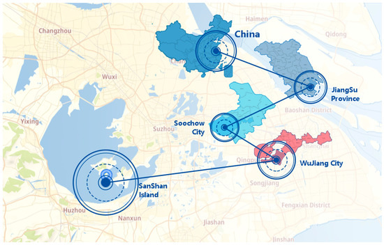
Figure 1.
Location Analysis of Research Samples.
In June 2021, the Suzhou Municipal People’s Government issued the ‘Several Policy Opinions on Supporting the Construction of Taihu Ecological Islands’, which emphasised enhancing rural environments and village landscapes, alongside supporting the conservation and utilisation of cultural heritage such as ancient structures, historic buildings, and traditional architecture [37]. In the same year, the Sanshan Island People’s Government issued the “Suzhou Sanshan Island Regional Tourism Development Strategy Plan and Feasibility Analysis Report”, proposing planning principles centred on sustainable utilisation and highlighting local and ethnic characteristics [38]. This provided both policy and practical foundations for Sanshan Island to employ digital technology in reconstructing historical sites and integrating historical legends to construct game environments.
3.2. Existing Resources and Conservation Status
The settlement pattern of Sanshan Island is structured around the natural framework of Beishan, Xingshan, and Xiaogushan hills. Clustered arrangements develop along the periphery near Dongbo Pier and Xianqi Pier, forming five distinct village units: Dongbo Village, Qiaotou Village, Xihu Village, Xiaogu Village, and Shandong Village (Figure 2). Within these settlements, historical structures, landscape heritage, and traditional dwellings are interwoven. Landscape heritage forms a network with a service radius of 100–200 m, reflecting the profound integration of natural and cultural spaces within traditional villages. The high density of cultural heritage on Sanshan Island provides spatial foundations for scene construction and task trigger point placement in gamified design.
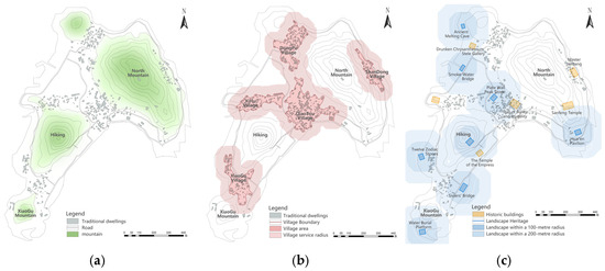
Figure 2.
Spatial Pattern Analysis of Sanshan Island: (a) distribution of mountainous terrain; (b) distribution of settlements; (c) distribution of traditional architecture and landscapes.
Based on field research and historical analysis [39], this study selected six representative sites as gamification demonstration subjects (Figure 3). These sites are distributed across different village areas, forming a spatial network that can be linked along a narrative thread. Specifically, the stone inscriptions at the Drunken Chrysanthemum Stele Gallery resonate with the architectural history of the Qing Dynasty at Shijiantang Hall; the religious relics at Sanfeng Temple connect with the residential character of Qingjiantang; and the cultural anecdotes of Qin Family Ancestral Hall relate to the symbolic landscape of Sisters’ Bridge, collectively demonstrating Sanshan Island’s potential for spatial storytelling. By weaving these narrative threads, users can gain an immersive understanding of traditional village culture.
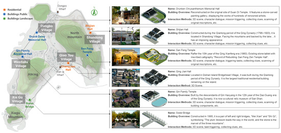
Figure 3.
Gamification Demonstration Sites and Content Table.
3.3. Design of Gamified Protection Methods
Combining the architectural characteristics of Sanshan Island with gamified conservation requirements, the conservation methodology may be developed across three dimensions: spatial restoration, narrative empowerment, and interactive experience. Firstly, for tangible elements such as ancient dwellings, temples, ancestral halls, and historic bridges, 3D modelling techniques are employed to precisely reconstruct spatial structures, thereby establishing real-time interactive 3D gaming environments. Secondly, by analysing historical records such as the San Shan Village Annals and oral histories gathered through field research, the historical narratives behind each structure are unearthed and transformed into plot threads for the game. Tasks such as ‘Restoring Ancient Dwellings’ and ‘Exploring Temple Ruins’ are designed, enabling the spaces themselves to become vessels for storytelling. Finally, interactive design incorporates folk elements like local dialects and traditional patterns, achieving the living transmission of the cultural heritage within this traditional village.
4. Gamification Development Methodology
4.1. Model Construction
4.1.1. Layout of Digital Information
The transformation of Sanshan Island’s imagery map into a gamified map centred on the reconstruction of geographical data into symbolic representations within the game space. This process commenced with oblique aerial photography to capture imagery, generating a high-precision point cloud model. Flight path planning for oblique photography encompassed range planning, altitude determination, overlap ratio calculation, and photographic scale setting. Given Sanshan Island’s generally moderate terrain complexity, the minimum bounding box method was employed to define the aerial survey boundary, with a buffer expansion factor set at 1.2. Operational parameters were set at a flight altitude of 80 m, 80% forward overlap, and 70% sideways overlap. This yielded a 3D model with 0.18 m accuracy and 0.06 m aerial resolution, meeting the 1:500 scale requirement. Finally, Sanshan Island’s DEM, DOM, and DLG data were extracted to construct a foundational geospatial dataset featuring authentic topographic characteristics and clearly defined spatial boundaries (Figure 4).
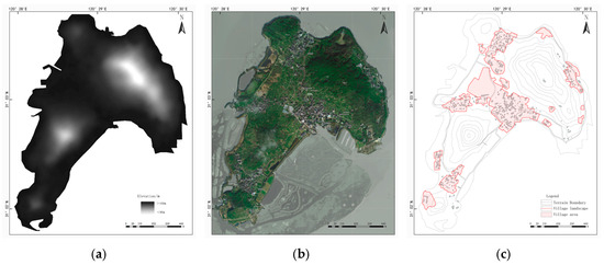
Figure 4.
Digital Information Extraction Layout for Sanshan Island: (a) DEM data; (b) DOM data; (c) DLG data.
The Revit platform achieves structured reconstruction of three-dimensional information through point cloud data interfaces: firstly, importing point cloud models in OBJ or FBX formats, utilising view filters to extract architectural plan outlines and elevation feature lines; subsequently, employing shape recognition algorithms to automatically detect orthogonal planes and regular geometric forms, generating parametric components such as walls, columns, and windows; finally, constructing a BIM model incorporating material properties, construction hierarchy, and spatial relationships (Figure 5). Compared to the original panoramic model, the individualised model reconstructed by Revit offers significant advantages: data lightweighting (model volume reduced to 12–15% of the original data), topological regularisation, and information structuring.

Figure 5.
Steps for Constructing Architectural 3D Realistic Models.
4.1.2. Topographic Map
The distinctions between photographic maps and gamified maps manifest primarily in three aspects. In spatial representation, photographic maps prioritise geographical accuracy, faithfully reproducing terrain and architectural proportions; gamified maps, conversely, de-emphasise detail in favour of symbolic recognition. Functionally oriented, photographic maps serve geographical surveying and spatial analysis, focusing on objective information transmission; gamified maps cater to game exploration and scene navigation, emphasising entertainment value and cultural identification. Regarding feature presentation, photographic maps encompass all elements including contour lines and image textures; gamified maps retain the core topographical framework while integrating gamified symbols to highlight cultural landmarks (Figure 6).
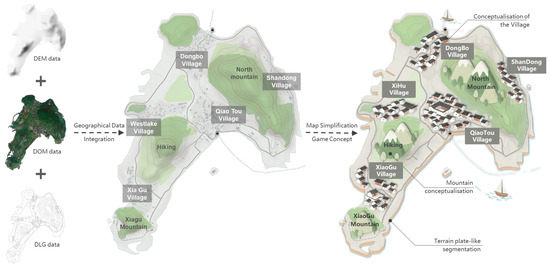
Figure 6.
Gamified Terrain Map.
4.1.3. Architectural Scene Model
The gamified modelling of landmark buildings in Sanshan Island’s traditional village represents a process of reconstructing Building Information Modelling (BIM) for compatibility with interactive gaming environments. Initially, BIM parametric modelling establishes the geometric form of architectural white models and applies authentic materials, fully preserving spatial information such as dimensions and construction details. Subsequently, these models are imported into the Unity engine, where they undergo lightweight optimisation according to gaming requirements and are supplemented with contextual elements, ultimately generating visual models adapted for interactive gameplay (Table 1).

Table 1.
Landmark Building Model Information Integration Table.
The core differences between these two modelling approaches manifest in the following aspects: Regarding information attributes, BIM emphasises the precise transmission of architectural parameters such as dimensions, materials, and construction details. Gamified modelling, conversely, de-emphasises certain parametric details, prioritising model lightweighting and interactive compatibility to suit the Unity engine. In functional scope, BIM serves architectural specialised needs by conveying objective information, whereas game-oriented models facilitate scene navigation and interaction triggers. Visually, BIM models pursue authentic material and structural reproduction, while game models balance visual style with rendering efficiency through simplified details and optimised lighting—all while preserving architectural character—to meet real-time interaction demands.
4.2. Interaction Settings
4.2.1. 3D Integrated Rendering Pipeline
The village model was processed using Unity’s built-in 3D rendering pipeline. This was achieved primarily through two technical approaches: firstly, model format conversion and data preservation. The model initially constructed in Revit underwent format conversion via Navisworks, ensuring the lossless transfer of spatial coordinates, component hierarchy, and material texture information. Subsequently, baking lightmaps at 2048 × 2048 px resolution, combined with real-time updating reflection probes and light probes using a 5 m sampling radius, established a dynamic lighting system for models successfully imported into Unity. Scene lighting data is generated using the lightmap baking technology within the built-in render pipeline. During system operation, the frame rate remains stable at 60 fps, with model polygon counts maintained below 5 million and memory usage ≤ 4 GB, meeting the performance requirements for high-quality real-time rendering and interaction.
4.2.2. Third-Person Perspective
In the implementation of a 3D dynamic interactive system based on the Unity engine, a third-person controller is employed for an integrated design encompassing ‘information input—character control—interaction triggering’. This system utilises the Character Controller component to manage character movement and physical collisions. Combined with the Animator Controller, it constructs an animation machine encompassing states such as walking, running, and turning (Figure 7). To address building obstructions within the scene, ray detection is employed to determine obstacles between the camera and character in real time, triggering automatic viewpoint shifts or semi-transparent occlusion processing to ensure visual continuity. At the interaction trigger level, the Physics.Raycast function detects interactive objects, prompting UI pop-ups. Upon user confirmation, an interface callback mechanism activates the interaction event [40].
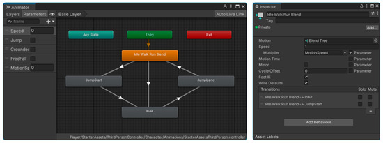
Figure 7.
Screenshot of Character Animation State Machine Configuration.
4.2.3. Virtual UI Interface
The virtual UI system, serving as the core medium connecting user operations with 3D scene feedback, adopts an event-driven architecture design. Its implementation comprises two distinct functional modules. The first is trigger-based interaction functionality, which employs Unity’s EventTrigger component to bind events such as clicks and drags to UI controls, thereby establishing communication links with 3D scene objects. The second category comprises parametric adjustment functions, employing Boolean controls for interactive state switching and Slider controls for dynamic parameter adjustment. Data binding technology synchronises UI control parameters with scene state updates, enhancing the intuitiveness and convenience of interactions (Figure 8).
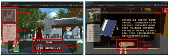
Figure 8.
Screenshot of the in-game interface.
4.2.4. ParadoxNotion Dialogue Tree
The research employs the ParadoxNotion plugin’s NodeCanvas dialogue tree to construct an integrated system linking narrative logic with scene interactions. At the dialogue structure design level, the Dialogue Tree component establishes a visual branching dialogue editor, supporting multi-path dialogue flows and adapting to different storylines. Concurrently, the Dialogue Actor component assigns dialogue identity markers to 3D characters within the virtual village. For interaction triggering, Condition nodes within the dialogue tree establish preconditions. Upon fulfilment, the Action Task mechanism invokes scene control interfaces to dynamically trigger character animations, object state transitions, and environmental updates. Furthermore, a global Blackboard variable stores user interaction progress, ensuring synchronisation of dialogue logic and interaction states across scenes.
4.3. Scene Setting
Online interactive scenarios are categorised into objective settings and interactive settings. This experiment, integrating the cultural resource characteristics of Suzhou’s Sanshan Island traditional villages, establishes nine distinct scenarios: Interactive settings fulfil functional navigation and core guidance roles, comprising the ‘Home’ interface for feature selection and game configuration; the “MapPuzzle”—a map information jigsaw embedding knowledge of Sanshan Island’s village layout; and the ‘MainMap’—a village world map presenting the overall spatial structure and key cultural nodes. Objective scenarios focus on representative cultural heritage sites of Sanshan Island, encompassing six core locations: ‘01 Drunken Chrysanthemum Stele Gallery’, ‘02 Qin Family Ancestral Hall’, ‘03 Sisters’ Bridge’, ‘04 Sanfeng Temple’, ‘05 Qingjian Hall’, and ‘06 Shijian Hall’.
4.3.1. Model Import
Importing the three-dimensional models of six scenes into Unity constituted the primary operation in the gamification of Sanshan Island’s traditional village cultural heritage. This aimed to visualise material cultural information and construct a spatial medium for intangible cultural heritage. To preserve the 3D model’s material properties, mesh structure, and texture data, this study uses Autodesk Revit (Autodesk_Revit_2020_G1_Win_64bit_dlm) as the pre-editing modelling software to export FBX format models. These were then imported into the Assets folder via the Unity Project view to complete loading. Imported data configurations can be viewed in the Inspector window. The specific parameter settings are as follows (Table 2):
Table 2.
Parameter Settings for Importing Three-Dimensional Models.
4.3.2. Scene Transition
Scene transitions are achieved by invoking Unity’s Scene Manager system to control scene loading, unloading, and switching: The interactive scene serves as the game’s primary entry point. Upon initial entry, users are directed to ‘MapPuzzle’ by default. After completing the village world puzzle, subsequent launches will proceed directly to ‘MainMap’; Within ‘MainMap’, transition channels directly connecting to all objective scenes are established. By attaching scene-loading scripts to Button components within the CanvasUI interface, clicking these triggers commands, enabling seamless switching between objective scenes and enhancing operational convenience (Listing 1).
| Listing 1. Script for scene transition. |
| 1 using System.Collections; 2 using System.Collections.Generic; 3 using UnityEngine; 4 using UnityEngine.SceneManagement; 5 public class TransScene : MonoBehaviour 6 { 7 public void S0(){ 8 SceneManager.LoadScene("Home"); } 9 public void S1(){ 10 SceneManager.LoadScene("MapPuzzle"); } 11 public void S2(){ 12 SceneManager.LoadScene("MainMap"); } 13 public void S3(){ 14 SceneManager.LoadScene("01醉菊碑廊"); } 15 public void S4(){ 16 SceneManager.LoadScene("02秦家祠堂"); } 17 public void S5(){ 18 SceneManager.LoadScene("03姐妹桥"); } 19 public void S6(){ 20 SceneManager.LoadScene("04三峰寺"); } 21 public void S7(){ 22 SceneManager.LoadScene("05清俭堂"); } 23 public void S8(){ 24 SceneManager.LoadScene("06师俭堂"); } 25 } |
4.4. Storyline Missions
4.4.1. Task Status Retrieval
Based on historical anecdotes recorded in the Chronicles of Sanshan Village, bespoke narrative scripts were crafted for each objective scene. Plotlines were triggered around specific NPCs by equipping Box Colliders with the ‘is Trigger’ attribute to these scene NPCs. When the player character entered the trigger’s detection range, the system automatically invoked dialogue trigger scripts, initiating interactive conversations with the NPC. The dialogue content incorporates both historical details and quest guidance, serving as a key path prompting players to proceed to the next scene. This achieves a natural integration of narrative and quest progression (Listing 2).
| Listing 2. Script for the initial conversation. |
| 1 using NodeCanvas.DialogueTrees; 2 using System.Collections; 3 using System.Collections.Generic; 4 using UnityEngine; 5 public class NPCTalk : MonoBehaviour 6 { 7 [SerializeField] DialogueTreeController dialogue; 8 private void OnTriggerEnter(Collider other){ 9 if (other.CompareTag("Player")){ 10 dialogue.StartDialogue(); 11 } 12 } 13 private void OnTriggerStay(Collider other){ 14 if (other.CompareTag("Player")){ 15 } 16 } 17 private void OnTriggerExit(Collider other){ 18 if (other.CompareTag("Player")){ 19 dialogue.StopDialogue(); 20 } 21 } 22 } |
4.4.2. Story Dialogue Tree
Employing NodeCanvas’ dialogue tree module to construct narratives follows this operational sequence: First, assign the DialogueActor component to characters to designate roles and visual interfaces. Subsequently, create nodes within the dialogue tree editor, selecting from types such as ‘Dialogue’, ‘Quest Action’, ‘Branch Option’, or ‘Control’. Additionally, dialogue text content may be dynamically updated via Blackboard global variables, replacing text with variable values according to player status.
Story content aligns closely with scene themes: (1) Drunken Chrysanthemum Stele Gallery: Engage with the Guan Gong statue at the entrance to learn ‘Drunken Chrysanthemum’-themed stele inscriptions and unlock the meaning behind the ‘Ink Affinity Hall’ plaque; (2) Master Jian’s Hall: Assist craftsmen in restoring the hall’s pillar couplets, explore the symbolism of the ‘Duty Reflects One’s Abode’ brick-carved gatehouse and the educational significance of its plaque; (3) Qin Family Ancestral Hall: Learn the ‘Eternal Exemplar of the Imperial Archives’ anecdote and study ancient architectural elements like cold-end arches and floral beam pads preserved within; (4) Sisters’ Bridge: Combine the history of the imperial quarry to collect zodiac stones and interpret the meanings of ‘Plum Blossom First’ and ‘Stone Wonder’; (5) Sanfeng Temple: Employ a non-linear approach to seek ancient relics within the temple grounds under the guidance of the gatekeeper. This journey may unlock assistance from a monk NPC in the Guanyin Hall to decipher the inscription on the Stele of the Reconstruction of Sanfeng Temple; (6) Qingjian Hall: 3D real-scene modelling enables free exploration from a first-person perspective, laying the groundwork for future platform design (Figure 9).
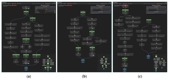
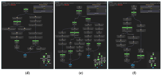
Figure 9.
Story Quest Dialogue Tre: (a) Drunken Chrysanthemum Stele Gallery Dialogue Tree; (b) Shijian Hall Dialogue Tree (1); (c) Shijian Hall Dialogue Tree (2); (d) Qin Family Ancestral Hall Dialogue Tree; (e) Sanfeng Temple Dialogue Tree (1); (f) Sanfeng Temple Dialogue Tree (2).
4.4.3. Task Completion Determination
The Collectible script employs the singleton pattern to ensure globally unique collection counts and dialogue trigger logic, preventing conflicts from multiple instances. Mounted on an empty scene object, its core responsibilities comprise two parts: firstly, maintaining the collectedCount variable to track the player’s collected items in real-time; secondly, automatically invoking the StartDialogue() method of the DialogueTree when this variable reaches a preset threshold to initiate dialogue. The entire task determination system employs a ‘collision component + counter management component’ to detect interactions. Coupled with the dialogue tree module to facilitate narrative progression, it can be directly applied to the development of mission-driven game scenarios (Listing 3).
| Listing 3. Script for task completion determination. |
| 1 using UnityEngine; 2 using NodeCanvas.DialogueTrees; 3 public class SimpleCollectionSystem : MonoBehaviour 4 { 5 [Header("收集设置")] 6 public int requiredCount = 5; 7 private int collectedCount = 0; 8 private bool isCompleted = false; 9 [Header("对话设置")] 10 public DialogueTree nextDialogue; 11 public static SimpleCollectionSystem Instance {get; private set; } 12 private void Awake(){ 13 if (Instance == null){ 14 Instance = this; 15 DontDestroyOnLoad(gameObject); 16 } 17 else{ 18 Destroy(gameObject); 19 } 20 } 21 public void CollectObject(){ 22 if (isCompleted) return; 23 collectedCount++; 24 Debug.Log($"已收集: {collectedCount}/{requiredCount}"); 25 if (collectedCount >= requiredCount) { 26 isCompleted = true; 27 TriggerDialogue(); 28 } 29 } 30 private void TriggerDialogue(){ 31 if (nextDialogue != null){ 32 nextDialogue.StartDialogue(); 33 Debug.Log("触发NPC对话"); 34 } 35 else{ 36 Debug.LogWarning("赋值对话树资源"); 37 } 38 } 39 } |
4.5. Strategy Summary
This chapter establishes a comprehensive pathway for gamified preservation of traditional village cultural heritage, encompassing ‘cultural heritage element extraction—real-time 3D interactive technology—game-mediated expression’ (Figure 10). It begins by extracting tangible and intangible cultural heritage content from traditional villages as core resources. Subsequently, the Unity engine’s real-time 3D interactive technology is employed to digitally translate the heritage. Scene construction integrates DEM bases, DOM textures, and DLG cultural information, utilising the 3D engine’s built-in rendering pipeline to construct dynamic three-dimensional environments. The interactive system relies on third-person perspective controllers, virtual UI interaction controls, NodeCanvas dialogue tree modules, and Blackboard global variables to achieve narrative spatial storytelling.
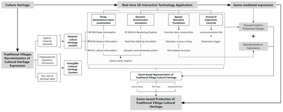
Figure 10.
Gamification Approach to Preserving Traditional Village Cultural Heritage.
This gamification strategy builds upon panoramic tours and narrative quests by introducing customisable editing capabilities for heritage elements. This empowers users to engage in the creative reconstruction of virtual heritage while fostering conservation awareness, propelling cultural heritage from passive preservation towards active creative value enhancement. It provides both technological support and innovative pathways for its sustainable development.
5. Testing and Effectiveness Evaluation
To validate the efficacy of gamified conservation techniques for traditional village cultural heritage, a week-long test survey was conducted from 28 October to 5 November 2025. The survey comprised three components: operational experience, instructional videos, and questionnaire responses. Participants were recruited online and engaged on an informed and voluntary basis. Standardised video instructions were employed to minimise experimental error by ensuring uniform operational procedures.
5.1. 3D Interactive Test
The operational phase was conducted within the Windows 11 system environment, utilising a custom application built with Unity version 2022.3.57f1c2 to validate the results. This engine supports multi-layer content integration including 3D models, text, sound effects, and visual annotations, delivering a rich visual experience. An Audio Listener component was added to the scene’s main camera to incorporate sound effects for character actions such as walking, running, and picking up items. Additionally, classical Jiangnan-style background music was configured for the environment, achieving an integrated audiovisual design (Table 3).
Table 3.
Experimental Environment Configuration.
5.2. Experimental Design
5.2.1. Survey Questionnaire
The evaluation centred on core dimensions including cross-disciplinary compatibility and public engagement. Given this study’s objective of developing a real-time interactive 3D game application for traditional village cultural heritage, a questionnaire was designed based on CML theory across three dimensions: ‘usability’, ‘intrinsic motivation’, and ‘intention to use’ [41], Comprising 26 items, these were structured as follows: Items 5–8 examined the impact of 3D technology on users’ cognitive processes; items 9–13 investigated the effectiveness of information transmission through interaction; items 14–21 measured users’ intrinsic motivation for exploratory learning; and the final items 22–26 assessed users’ intention to use the technology (Table 4). Each questionnaire item employed a Likert scale (typically 5-point, ranging from ‘strongly disagree’ to ‘strongly agree’) for scoring [42], quantifying users’ attitudes and perceptions across each dimension.
Table 4.
San Shan Island Gamification Real-Time 3D Technology Application Scale and Items.
5.2.2. Participants
This study involved 71 participants, comprising 47.88% males and 52.12% females, aged between 18 and 40 years (mean age 26.06 years). Sixty-seven point one six per cent possessed over three years of gaming experience. All participants provided informed consent, explicitly acknowledging the experiment’s purpose to investigate perceptions and requirements regarding gamification techniques on Sanshan Island. Ultimately, 67 valid questionnaires were retrieved, yielding a response rate of 94.37% (Table 5).
Table 5.
Sample Population Composition Analysis.
5.3. Analysis of Results
The figure below presents questionnaire results based on a 5-point Likert scale, quantifying user attitudes across 26 questions through three dimensions: technical ease of use, cultural cognition, and scenario intention. The data indicates that within the technical usability dimension, over 77% of respondents expressed agreement or strong agreement regarding the application’s interaction design. However, evaluations of 3D character realism revealed significant room for improvement. Within the cultural cognition and behavioural intention dimensions, users demonstrated high recognition of the cultural core and the effectiveness of gamified cultural dissemination. Furthermore, there exists a pronounced demand for extending gamified models into educational and social scenarios (Figure 11).
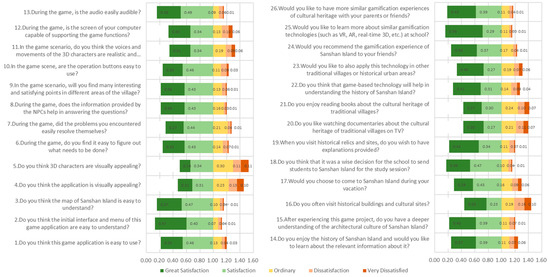
Figure 11.
Frequency Distribution Chart of Gamification Indicator Projects on Sanshan Island.
5.3.1. Reliability Analysis
Reliability comprises external reliability (consistency of repeated measurements) and internal reliability (consistency of items within the questionnaire). In academic research, α > 0.8 is generally regarded as the benchmark for high internal reliability, while α < 0.6 indicates items require revision until reliability standards are met. Given that split-half reliability imposes stringent data assumptions, its application is highly constrained. Due to these limitations and the absence of repeated measurements in this study, Cronbach’s α coefficient was employed to assess internal reliability.
The empirical results indicate that the overall Cronbach’s α coefficient for the questionnaire was 0.879 (Table 6). Within the technical usability sub-dimension, the α coefficients were: 0.866 for user information, 0.888 for user interaction, 0.841 for intrinsic motivation, and 0.938 for usage intention. user cognition α = 0.892, and user interaction α = 0.888; while the intrinsic motivation dimension α = 0.841 and the intention to use dimension α = 0.938. All values exceeded the 0.8 benchmark, indicating the questionnaire possesses good internal consistency and reliable validity (Table 7).
Table 6.
Reliability Testing of Questionnaire Data.
Table 7.
Reliability Analysis of Questionnaire Sub-Dimension.
5.3.2. Validity Analysis
Validity refers to the degree of correspondence between a questionnaire’s measured outcomes and true outcomes. Common analytical methods include content validity, criterion validity, and construct validity. Content validity assesses an item’s representativeness of the measurement theme, though logical analysis carries significant subjectivity. Criterion validity requires exploring correlations against established benchmarks, yet the difficulty in selecting such benchmarks limits its practical application. This study employed the KMO measure of sampling adequacy and Bartlett’s sphericity test to assess data suitability for factor analysis: the KMO value of 0.909 substantially exceeded the accepted threshold of 0.8, indicating sufficient common factors among variables. Bartlett’s sphericity test yielded an approximate chi-square value of 2121.971 (df = 325, p < 0.001), rejecting the unit matrix hypothesis. This further confirms the sample data’s sound suitability for factor analysis, providing a foundational guarantee for subsequent structural validity testing (Table 8).
Table 8.
Validity Testing of Questionnaire Data.
The findings of this investigation validate the feasibility of gamified conservation technology through both reliability and validity assessments alongside core dimension evaluations. Reliability and validity analyses indicate that the questionnaire meets academic standards for overall reliability and construct validity, establishing the measurement tool as dependable. Within the three-dimensional evaluation framework: interaction design received broad recognition for its user-friendliness, though character realism requires enhancement; gamified dissemination demonstrated pronounced efficacy in cultural cognition; and educational and social extension needs were clearly identified in scenario orientation. Testing findings indicate this technology holds significant potential for conveying traditional village cultural values, while also guiding future optimisation: refinement of interactive model details is required, alongside expanding multi-scenario application forms to further enhance user experience and practical technological value.
6. Discussion and Limitations
Within the scope of this study, the Unity engine was selected to test real-time 3D gamification technology for the cultural heritage of Sanshan Island’s traditional villages. Research indicates that existing literature documents digital reproduction techniques for preserving traditional village cultural heritage. However, observations reveal limitations in conventional methods regarding the procedural expression of cultural origins and construction wisdom [17,18]. Consequently, this study proposes a gamified expression pathway for traditional village cultural heritage. Regarding test survey data, the key technological research for Sanshan Island’s gamification exhibits the following characteristics: (1) Players’ most profound impressions of village architecture and historical culture stem from interactions with characters within the game environment. (2) Research into traditional village cultural heritage information and key technologies aims not only to deepen understanding of the past but also to cultivate cultural identity and national belonging. (3) The project employs real-time 3D interactive technologies—including 3D scene modelling, mission narratives, and NPC dialogue—to achieve a narrative representation of traditional village spaces.
The primary limitations of this study lie in the testing phase being conducted under restricted device configurations and user profiles. Furthermore, feedback indicates that the technology still exhibits shortcomings in model aesthetics beyond architectural elements. Moreover, the plot structure appears somewhat thin; future iterations should enhance the interconnectedness of narrative nodes to achieve comprehensive spatial storytelling. Subsequent research should expand the sample size of study subjects and conduct testing across diverse hardware and software configurations to objectively validate the broad applicability of this gamified preservation methodology.
7. Conclusions
This study aims to explore the application of key gamification technologies for traditional village cultural heritage, thereby transcending disciplinary boundaries between digital media and cultural heritage conservation. Through gamification pathways, it seeks to achieve the living transmission and sustainable development of traditional village cultural heritage. Through systematic user testing and data analysis, the research has yielded the following core conclusions.
Empirically validated, real-time 3D technology, as the core technological engine, demonstrates significant application potential in research at the intersection of gaming and architectural cultural heritage. Theoretically, the established interdisciplinary framework—‘model carrier-cultural narrative-cognitive enhancement’—first clarifies the positioning of real-time 3D technology as a ‘dynamic narrative medium’ in heritage conservation. This addresses the theoretical shortfall where traditional digital preservation prioritises static documentation while neglecting cultural substance, thereby enriching the theoretical system for architectural heritage digitisation. From an applied perspective, the immersive interactive environments constructed by this technology deeply integrate fragmented historical information with the built environment. By analysing complex historical contexts through concrete, dynamic representations, it facilitates users’ transition from visual perception to cultural cognition regarding traditional village heritage. This positions the technology as an innovative tool within the preservation and transmission system for traditional village cultural heritage.
As an innovative vehicle for cultural transmission in the digital age, gamification technology employs interactive narrative as its core mechanism. This approach overcomes the static presentation limitations inherent in traditional conservation models, transforming the physical spaces of traditional villages into dynamic environments that evolve with the unfolding storyline. Field testing on Sanshan Island demonstrates this methodology’s positive impact on enhancing public cultural awareness. Subsequent research should further focus on the cultural translation capabilities of the technology, pursuing multidimensional optimisation in three key areas: the historical authenticity of in-game visuals, the cultural logic of dialogue systems, and the relevance of narrative quests to heritage. This will ultimately provide a technical paradigm for the digital preservation of traditional village cultural heritage that combines academic depth with practical value, while unlocking the deeper enabling potential of gamification technology in the field of cultural transmission.
Author Contributions
Y.Z.: methodology, software, validation, formal analysis, data curation, writing—original draft preparation; Z.L.: supervision, writing—review and editing, project administration, funding acquisition. All authors have read and agreed to the published version of the manuscript.
Funding
This research was funded by the 2022 National Social Science Fund General Project ‘Research on Digital Preservation and Inheritance of Traditional Chinese Villages in the New Era’, grant number 22BSH086. This research was funded by the 2025 Suzhou Municipal Social Science Fund Project (Applied Policy Category) ‘Research on Digital Twin-Empowered Sustainable Renewal Strategies for Ageing Communities in Suzhou’, grant number Y2025LX165. This research was funded by one of the interim outcomes of the 2025 Key Research Project of the Chinese Association for Ethnic Architecture, ‘Research on the Digital Preservation, Utilisation and Transmission of Traditional Chinese Architectural Construction Techniques: The Case of Suzhou’s Xiangshan Guild’, grant number NAIC202510.
Data Availability Statement
This study did not generate any new datasets. All data analyzed are from publicly available sources, as cited in the manuscript.
Conflicts of Interest
The authors declare no conflict of interest. The funders had no role in the design of the study; in the collection, analyses or interpretation of data; in the writing of the manuscript; or in the decision to publish the results.
References
- He, Z.; Liu, J.; Tian, J.; Gao, C. Research on the Digital Preservation and Inheritance of Traditional Villages Based on the Full Life Cycle. Small Town Constr. 2023, 41, 46–52. [Google Scholar]
- Tao, H.; Wen, Y.; Wang, L.; Chen, L. The Evolution of Representation and Place-Making in Traditional Villages from a Digital Media Perspective: The Case of Taipan Village, Taijiang County, Guizhou. Adv. Geogr. Sci. 2025, 44, 1911–1924. [Google Scholar]
- Tang, R.; Ye, Y. Symbols, Narratives, and Interaction: A Triple Narrative Model for Digital Games to Tell Chinese Stories Effectively. Mod. Commun. (J. Commun. Univ. China) 2023, 45, 43–51. [Google Scholar]
- Xu, H.; Gong, Y.; Zhang, A. Research on Serious Game Design for Cultural Heritage Education. Art Des. Res. 2024, 4, 87–94. [Google Scholar]
- Wang, Y.; Yin, R.; Peng, Y. Exploring Architectural Space Design Teaching Practices Based on Film and Gaming Media. New Archit. 2025, 60–65. [Google Scholar]
- Pearson, L.C.; Youkhana, S. Videogame Atlas: Mapping Interactive Worlds; Thames & Hudson: London, UK, 2022. [Google Scholar]
- Tsiliakos, M.; Bassing, S.; Tian, D.; Gong, J.; Huang, Q.; Huang, Q.; Liu, H. Eduverse: Exploring Gamification and the Metaverse in Architectural Pedagogy. In Proceedings of the CAADRIA Proceedings, Singapore, 20–26 April 2024. [Google Scholar]
- Harriss, H. Ludic Architecture: Playful Tools for Participation in Spatial Design. Des. Princ. Pract. Int. J.—Annu. Rev. 2010, 4, 175–186. [Google Scholar] [CrossRef]
- Rybkowski, Z.; Jeong, D. Research Topic 1: Virtual Reality-Based Serious Simulation Games for Construction; Texas A&M University, College of Architecture: College Station, TX, USA, 2023. [Google Scholar]
- Yu, C. The Transformation of Media: An Analysis of Virtual Architectural Design Projects Based on Interactive Game Engines. In Computational Design and Analysis: Proceedings of the 2013 National Seminar on Digital Architecture Technology Teaching in Architectural Faculties; National Committee for Architectural Discipline in Higher Education Institutions, Teaching Committee for Digital Architecture Technology, Eds.; School of Architecture, Southeast University: Nanjing, China, 2013; pp. 184–187. [Google Scholar]
- Yang, J. Fluid ‘Urban’ Spaces in Public Buildings of the Digital Age: The Rolex Learning Centre and Taichung Opera House as Case Studies. Archit. J. China 2023, 10–15. [Google Scholar] [CrossRef]
- Li, J.; Yan, J. An Initial Exploration of Public Participation in Urban Planning Inspired by Remix Online Games. South. Archit. 2016, 75–79. [Google Scholar] [CrossRef]
- Huang, S. Eduardo Rico Carranza Serious Games as a Methodological Approach to Public Engagement in Urban Landscape Planning. Chin. Landsc. Archit. 2025, 41, 21–29. [Google Scholar]
- Li, Z.; Cheng, G.; Wang, Q.; Gao, M.; Fang, Q. Research on Digital Perception Technologies for Traditional Huizhou Villages under Concentrated Cluster Protection and Utilisation Objectives. Acta Naturarum Resur. Sin. 2025, 40, 402–422. [Google Scholar]
- Du, P.; Chen, J. Exploring Digital Revitalisation Pathways for Cultural Landscape Heritage in Shenao Village, Zhejiang. Zhejiang Arch. 2023, 11–14. [Google Scholar] [CrossRef]
- Yang, L.; Ning, W. Digital Intelligence-Driven Pathways for Cultural Tourism Integration in Traditional Villages: A Structuralist Perspective. Econ. Geogr. 2024, 44, 218–227. [Google Scholar]
- Wang, P.; Lei, J. Digital Dissemination of Traditional Village Culture: Current Status, Challenges and Responses. Library 2019, 7–12, 22. [Google Scholar]
- Fu, J.; Huang, D. Research on the Spatial Morphology of Traditional Villages Based on GIS Spatial Analysis Methods: A Case Study of Zengcheng District, Guangzhou. South. Archit. 2016, 80–85. [Google Scholar] [CrossRef]
- Yan, J.; Li, S.; Zhong, J. Research on the Virtual Reality-Based Exploration System for Shanggan Tang Village. Archit. Sci. 2008, 52–56. [Google Scholar] [CrossRef]
- Sun, Y.; Yu, G.; Zhang, C. Application of Digital Museums in the Preservation of Cultural Heritage in Traditional Villages. New Archit. 2019, 97–99. [Google Scholar]
- Liu, P.; Li, B. Origins, Misconceptions and Responses in the Digital Preservation of Traditional Villages. J. Cap. Norm. Univ. (Soc. Sci. Ed.) 2018, 140–146. [Google Scholar]
- Chen, S.; Li, Y. Application of VR Technology in the Digital Preservation and Transmission of Traditional Villages: The Case of Shemi Lake Village, Enshi. Ind. Des. 2025, 119–123. [Google Scholar] [CrossRef]
- Rusnak, M.; Kilijańska, B.; Garaszczuk, I.; Duchowski, A.; Biegańska, M.; Dobrasiak, D.; Koszewicz, Z. From Eye-Tracking to Games: Exploring Low-Tech Solutions for Sustainable Cultural Landscape Management. J. Cult. Herit. 2025, 74, 225–235. [Google Scholar] [CrossRef]
- Wei, Y. Research on Cultural Tourism Development Strategies Based on Immersive Experiences: The Case of Nanping Village, a Traditional Huizhou Settlement. China Packag. 2022, 42, 78–81. [Google Scholar]
- Ge, H. Guiding Adaptive Design of Ancient Village Landscapes in Dabie Mountains Using Virtual Reality (VR) Technology: A Case Study of Eight Ancient Villages in Xinyang, Henan. Art Des. (Theory) 2022, 2, 128–130. [Google Scholar]
- Kidd, J.; Nieto McAvoy, E. Immersive Experiences in Museums, Galleries and Heritage Sites: A Review of Research Findings and Issues; PEC Discussion Papers; PEC: Cardiff, UK, 2020. [Google Scholar]
- Zhang, R.; Peng, F.; Gwilt, I. Exploring the Role of Immersive Technology in Digitally Representing Contemporary Crafts Within Hybrid Museum Exhibitions: A Scoping Review. Digit. Creat. 2024, 35, 355–377. [Google Scholar] [CrossRef]
- Yoo, Y.S. Korean Folk Village as a Model for Realising Virtual Traditional Culture World in Metaverse. In Proceedings of the Korean Content Association ICCC (2021), Jeju, Republic of Korea, 19–21 December 2021. [Google Scholar]
- Yu, J.; Hu, J.; Liu, G.; Jiang, W.; Walters, G. Not Just a Game: Understanding Eco-Gamification in Sustainable Destination Development. J. Hosp. Tour. Manag. 2024, 60, 10–21. [Google Scholar] [CrossRef]
- Li, H. Rural Life in the Media Context. Soc. Sci. Frontline 2023, 282, 165–178. [Google Scholar]
- Liu, H.N.; Xu, Y.F. Theoretical Application Research on the ‘Gamification’ of Urban Spaces. New Archit. 2020, 67–71. [Google Scholar]
- Yang, F.; Dou, Y.; Yi, Y.; Liu, X.; Li, B.; Liu, P. Mechanisms and Pathways for Tourism-Driven Common Prosperity in Traditional Villages from a Catalytic Perspective: The Case of Banliang Village, Hunan Province. Acta Nat. Resour. Sci. 2023, 38, 357–374. [Google Scholar] [CrossRef]
- Zhang, J.; Du, L. Experiment and Solution for Interdisciplinary Collaborative Surveys in Rural Cultural Heritage Protection. Chin. Cult. Herit. 2020, 4–11. [Google Scholar]
- Bartle, R. Hearts, clubs, diamonds, spades: Players who suit MUDs. J. MUD Res. 1996, 1, 19–42. [Google Scholar]
- Zichermann, G.; Cunningham, C. Gamification by Design: Implementing Game Mechanics in Web and Mobile Apps, 1st ed.; O’Reilly Media, Inc.: Sebastopol, CA, USA, 2011. [Google Scholar]
- Deterding, S.; Dixon, D.; Khaled, R.; Nacke, L. From game design elements to gamefulness: Defining ‘gamification’. In Proceedings of the 15th International Academic MindTrek Conference: Envisioning Future Media Environments, New York, NY, USA, 28–30 September 2011; pp. 9–15. [Google Scholar]
- Suzhou Municipal People’s Government. Several Policy Opinions on Supporting the Construction of Taihu Ecological Islands (Su Fu [2021] No. 57); Suzhou Municipal People’s Government: Suzhou, China, 2021.
- Sanshan Island People’s Government. Suzhou Sanshan Island Regional Tourism Development Strategy Planning and Feasibility Analysis Report; Sanshan Island People’s Government: Laizhou, China, 2019.
- Compilation Committee of Sanshan Village Annals. Annals of Sanshan Village; Local Chronicles Press: Beijing, China, 2018. [Google Scholar]
- Cheng, P.; Song, C. 3D Virtual Tour System Based on Unity3D Engine. J. Chengdu Text. Coll. 2014, 31, 24–28. [Google Scholar]
- Capecchi, I.; Bernetti, I.; Borghini, T.; Caporali, A.; Saragosa, C. Augmented Reality and Serious Game to Engage the Alpha Generation in Urban Cultural Heritage. J. Cult. Herit. 2024, 66, 523–535. [Google Scholar] [CrossRef]
- Yang, C.; Yang, Q. Application of SPSS Project Analysis in Questionnaire Design. J. High. Corresp. Educ. (Nat. Sci. Ed.) 2010, 23, 107–109. [Google Scholar]


Disclaimer/Publisher’s Note: The statements, opinions and data contained in all publications are solely those of the individual author(s) and contributor(s) and not of MDPI and/or the editor(s). MDPI and/or the editor(s) disclaim responsibility for any injury to people or property resulting from any ideas, methods, instructions or products referred to in the content. |
© 2025 by the authors. Licensee MDPI, Basel, Switzerland. This article is an open access article distributed under the terms and conditions of the Creative Commons Attribution (CC BY) license.