Abstract
The settlement space along China’s Grand Canal composes an important part of the Canal heritage, has a close bearing on the production and life of the residents there, nourishes rich culture and wisdom and boasts vital value of conservation and inheritance. Due to China’s rapid urbanization and industrialization, the settlements along the canal have been destroyed to some extent and their in-site characteristics urgently need excavation and conservation. Through field investigation, space syntax and GIS analysis, this paper performs quantitative analysis of the in-site characteristics of 18 typical rural settlements there. The findings show that: (1) The settlement space of industry dominant type for commerce and trade is comparatively dynamic and the capacity of topology and integration and the attractive force of the settlement center are stronger. (2) The dynamic scope of the citizens’ everyday traveling in the settlements has the closest correlation with the data of public-service facilities. (3) The settlements along the canal boast multiple, causal and blended in-site phenotype. The research findings provide new standards to categorize the settlements along China’s Grand Canal, paths and methods to explore the characteristics of the settlements and new cognitive perspectives to conserve and renew the settlements along China’s Grand Canal Tianjin Section.
1. Introduction
China’s Grand Canal, created during Ancient China in 486 B.C., is a great water conservancy project and the world-earliest canal residing on China’s eastern plain. China’s Grand Canal consists of three parts: Jing-Hang Canal, Sui-Tang Canal, and East-Zhejiang Canal, which makes it the longest canal in the world. China’s Grand Canal spans over 10 Earth latitudes related to 8 Chinese provincial administrations, and served as the main artery of North–South transportation in Ancient China. In June 2014, China’s Grand Canal was approved to be included in the World Heritage List as the 46th World Heritage item of China. Since 2019, the state has successively issued the Guideline for Conserving and Inheriting the Grand Canal Culture, determining the planning system to conserve, inherit and utilize the canal culture, and effectively guided the conservation, inheritance and utilization of canal culture. China’s Grand Canal nourishes towns and rural settlements and enriches the abundant wealth and brilliant culture there. Since China’s reform and opening-up, especially in the last 30 years of rapid urbanization and industrialization, large-scale urbanization has caused damage to settlements along the canal, and the local characteristics have been gradually lost and the in-site characteristics of the settlements badly require excavation, conservation and inheritance.
The research on canal heritage keeps up with the times. With continuous improvement to the content, a research system has been gradually formed which includes water resources management [1], ecological environment management [2,3], canal region [4,5], and canal projects [6]. Recently, some scholars on canal village development have discussed the development potential [7] of canal village tourism by means of rhythm analysis. Most of their research on China’s Grand Canal has focused on ecological management [8,9] and canal projects, while research on rural settlements was much more limited. The research on conserving and developing settlements along the canal centered more on settlements in cities and towns, from the perspectives of the history of urban development [10], special investigation [11], spatial evolution [12], spatial distribution [13], value cognition [14], and conservation and utilization [15]. Although some scholars have carried out research on these rural settlements in recent years, and their research has mostly selected famous historical and cultural villages and traditional villages as targets [16], failing to classify the in-site phenotype of different rural settlements from a holistic view.
China’s Grand Canal Tianjin Section (hereinafter referred to as “Tianjin Section”) plays a pivotal role in the development of commerce and trade and the social economy of North China. “In-site” is a natural and cultural attribute particular to an area, boasting multi-scale, multi-dimensional characteristics according to the natural features, history, culture, and customs native to the area [17]. The present research applied such methods as field investigations, spatial syntax, and GIS to quantitatively analyze the in-site characteristics of typical settlements along the Tianjin Section. It proposed the types of settlements along the canal and the paths and methods for researching their in-site characteristics. It adopted the GIS-sDNA syntax model to perform modeling analyses of different types for rural settlements to compare and analyze their configuration characteristics. Meanwhile, it also compared the relevance between the configuration characteristics of the settlement space and the diachronic and synchronic data, brought forth the in-site characteristics of different types of settlement space, and revealed the inherent social logic of the settlement space along the Tianjin Section.
First, the research primarily selected 18 typical settlements along Tianjin Section to undertake field investigations and interview villagers; we acquired data on cultural heritage, tourist resources, public service facilities, and industrial resources and the resource point data were entered into a GIS database. Second, spatial modeling was applied to Google Maps data and was rearranged into ArcMap to create a spatial configuration model to determine the best possible model, including the canal, surrounding water system, settlement space forms, and land for road transport and production. Third, GIS-sDNA was applied to analyze the NQPDA, TPBt, and nuclear density of the spatial configuration. Finally, correlated analysis of the result of spatial configuration characteristics and the diachronic and synchronic investigation data was conducted and summarized, as was the in-site phenotype and law.
2. Research Area and Type Classification
Tianjin lies on the North China Plain border, borders on the Bohai Sea to the east and the west of Beijing, the capital city of China. According to official records, the government of the Ming Dynasty renamed “Haijin Town”, a small town along the canal, into “Tianjin” in 1404, where the defense facilities were constructed (Figure 1). With the prosperity of grain transport and a garrison of troops, and thanks to its advantageous military and geographical position, Tianjin gradually became an important city along the canal and a portal for Beijing. China’s Grand Canal drove the exchange of goods and materials between North and South China, encouraged cultural exchange, and stimulated vigorous development of settlements along the canal.
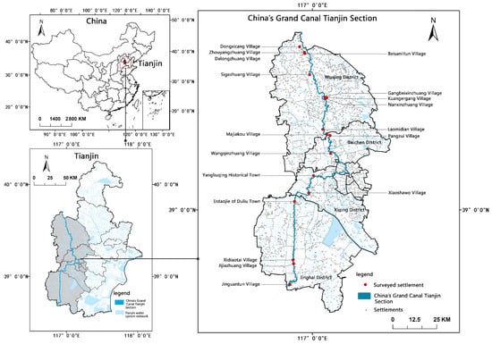
Figure 1.
Spatial distribution of the sample settlements.
China’s Grand Canal stretches about 182.6 km in Tianjin. The settlements along the canal boast typical features of villages in North China and are typical along the canal. Wuqing District, Beichen District, Qingxi District, and Jinghai District, apart from the city proper, were defined to be in the scope of the settlements along the Tianjin Section to guarantee the diversity and timeliness of the research objects. The selection of typical rural settlements along the Tianjin Section followed the standards of diversity and balance to ensure the typicality and representativeness of the research cases. The settlements along Tianjin Section were divided into four major types, with 16 sub-types for grain-transporting dominant type, industry dominant type, history dominant type, and folk customs dominant type, referring to the historical facts of the canal and the annals of local areas and after a field investigation (Figure 2). The settlements of the grain transporting dominant type refer to the settlements along the canal built for canal digging and dredging, grain transportation and military demands of the country, including the following five sub-types, channel topography, ferries and wharves, dredging intake channels, warehouses, and garrisons. The settlements of the industry dominant type refer to those along the canal for industries such as business, fishery, agriculture, and the handicraft industry, formed depending on grain transportation. The settlements of the history dominant type refer to those along the canal boasting important historical elements, such as typical historical relics, ancient architecture and historical figures. The settlements of folk custom dominant type refer to those built for unique traditional music, traditional dance, traditional handicraft and folklore with the development of grain transporting, and include traditional performance, traditional handicraft and oral traditions. In total, 18 typical sample settlements along the Tianjin Section were selected for in-depth research according to the above categorization (Figure 1 and Figure 2, Table 1).
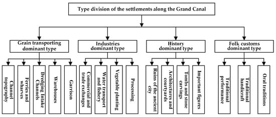
Figure 2.
Type division of the settlements along the canal.

Table 1.
Basic attributes of the sample settlements.
3. Research Methods
3.1. Theory and Practice of Space Syntax
Space syntax is the paradigm of theoretical research, systematically analyzing architectures and urban space, as proposed by Bill Hillier [18]. The theory of space syntax reveals the essential property of space and society, promotes the importance of “spatial ontology” to new heights, and provides brand new theories and tools to research architecture, urban and rural planning, and human geography. The core connotation of the space syntax theory includes spatial configuration, space division, and natural through-movement [19], specifically shown by the following three aspects: (1) Spatial configuration stresses the holistic relation, refers to a series of correlations of local space (like urban roads), and depends on the entire system [20]. The coinventor of space syntax, Julienne Hanson, proposed decoding the space of a house with the purpose of exploring and explaining abundant social and symbol information [21]. (2) Space division adopts the quantitative method of geometry and topology to better understand people’s behaviors and perceptions in a space. For instance, analysis of a street network can help perceive the evolution of land use and further influence the mode of life in a city on the whole [22]. (3) Natural through-movement boasts high value for researching large urban spaces. “The main attribute of the city grid is to make some space superior to other space through movement. The structure of the city grid itself is the main producer of the mode of movement” [23].
The proposal of the space syntax theory provided new methods and techniques to understand and research settlement spaces [24,25,26], specifically shown from the following perspectives (Figure 3): (1) The evolutionary mechanism of the form of a settlement space. Through the quantitative analysis of the spatial configuration, it put forth a dynamic relation between social functions and space [27] and explored the factors and rules of settlement space that formed their evolution [28]. (2) The features of the phenotypes of settlement spaces. Analysis methods, such as the axis model and segment model were applied to reveal rules and characteristics, as well as the influencing factors, of the phenotype of settlement spaces [29]. (3) The actual testing, investigation, and structural analyses, on the one hand, explained the relationship between spatial form and citizens’ perceptions of a space and inspired future planning for developments [30]. On the other hand, it discussed the influence of spatial forms on the travel model, explained the guidance of different travel scales for spatial evolution, and discerned the underlying rule of a settlement space form [31]. (4) The cultural genes of a settlement space; measures, such as J-shaped graph, visual analysis, and testing analysis were applied to perform a quantitative analysis of the settlement architectures, streets, and lanes to explore their social and cultural logic [32]. In brief, space syntax started from spatial ontology, performs quantitative analysis of the features of a space form, the rule of evolution, the social functions, and the cultural logic, and provided a feasible technique to quantitatively research on the “in-site characteristics” of a rural settlement space along China’s Grand Canal.
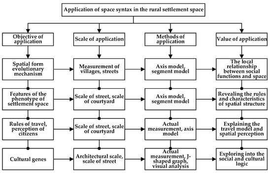
Figure 3.
Application of space syntax in the rural settlement space.
3.2. GIS-sDNA Model Parameters
Spatial design network analysis (sDNA) is a new space syntax modeling tool that can enhance computational stability, draw accurate line models, and undertake various spatial analyses and visualized expressions using GIS geostatistical analysis [33]. This paper performed quantitative analyses of segment models of typical settlements along the Tianjin Section using GIS-sDNA software. Important parameters of GIS-sDNA selected for the present research include:
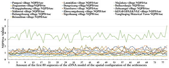
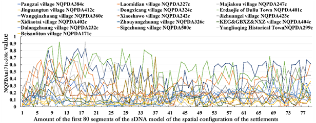
➀ Proximity (NQPDA): This represents the difficulty degree of other road networks within the search radius of a certain road network. A road network with a higher proximity boasts higher topological integration capacity and centrality and has more attraction for traffic flow traveling through this area.
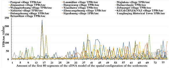
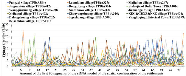
➁ Through-movement degree (TPBt): Used to measure the probability of traffic flow within the search radius of a road network. The higher it is, the stronger the trafficability characteristic is and correspondingly the more passenger and vehicle flows it bears (In the formula, OD(y, z, x) indicates the total amount of the nodes through node x within search radius R, Link(y) represents the total amount of the nodes of each node y within search radius R and p(z) indicates the weight of node z).
Note: OD(y, z, x) is the shortest topological path between node y passing nodes x and z within radius R; is the result of the degree of movement through node x.
➂ The kernel density analytical approach: The kernel density analytical approach calculates the unit area according to the characteristics of the dots or broken lines, applying a kernel function to match a smooth tapered curve to each dot or broken line. It can improve the visualization quality of the results of the space syntax model and differentiate and analyze the core and evolutionary tendency of a road network.
m is the number of observations, h is the smoothing parameter or bandwidth (h > 0), K is the kernel function, and (x − ) is the distance between the estimated point x and the event point .
At present, sDNA is academically applied to traffic network flow forecasting and model choice in the discipline of transportation [34,35]. Some scholars have applied sDNA and POI data to research the association between city forms and urban vitality and summarized the positive influence of blocks and belt types on urban vitality [36]. Ye and Yeh et al. [37] proposed combining the formal grammar tool “Form Syntax” with space syntax, spatial matrix, and blending to measure street topology, building density, and functional grouping, respectively. The three components can be quantized and combined to represent the phenotype of a city so as to categorize the degree of urbanization.
3.3. Data Sources and Processing
3.3.1. Basic Data Collection
Data collection for the settlements along the Tianjin Section included collection from diachronic and synchronic dimensions. The diachronic dimension is aimed at investigating unique resources formed during the historical evolution of settlements along the canal. Diachronic data chiefly include data of the tangible and intangible cultural heritage of the settlements along the canal. The data on cultural heritage were acquired from the Detailed Rules and Regulations on Controlling the Space of National Land in the Core Monitoring Area of the Grand Canal Tianjin Section, the Tianjin Intangible Cultural Heritage Website, and field investigations. The synchronic dimension is aimed at investigating the particular resources in settlements along the canal for the time being. Synchronic data primarily include data regarding tourist resources, public-service facilities, and industrial resources of the settlements there. First-hand data were acquired by the authors through field investigations into rural settlements and through interviews with villagers from February to July, 2021, and the resource point data were entered into a GIS database (Table 2).
Table 2.
Data collection for the settlements along Tianjin Section.
3.3.2. Space Modeling Data
Quantitative descriptions were made using the segment model based on GIS-sDNA to analyze the phenotype of spatial configurations of the 18 typical rural settlements along the Tianjin Section. The Google Map data, with a resolution ratio of 0.3 m, were adopted to draw a line model in ArcMap to reduce the model errors, ensure analytical effectiveness, and appropriately expand the model [38]. The modeling data included the canal, the surrounding water system, the form of the settlements, the land for roads and transportation, and the ecological space. The characteristics of the centrality of the spatial configuration of rural settlements of diverse scales were obtained by analyzing the configuration phenotype of settlements using the overall and local scales with GIS-sDNA. The research took the mostly frequented public settlement spaces, namely, a square or village committee, as the radius of daily travel to reveal the core zone, marginal zone, and activity scope of the settlement space. The standard of local travel radius was set to be the mean radius with the public space of the rural settlements as the center. Therefore, the local core scopes of different rural settlements were different according to their sizes. Generally speaking, the local core radius of rural settlements along the Tianjin Section ranged between 200–500 m.
3.4. Framework of Research on the In-Site Phenotype of the Settlements along the Canal
“In-site phenotype” is a natural and cultural attribute of a local area, boasting the characteristics of multiple scales and dimensions thanks to unique natural features, historical concerns, culture, and folk customs [17]. It is a unique in-site feature of an area and the external expression of “in-site genes” [39], and is comparatively stable, measurable, analyzable, and beneficial for clarifying the reasons for, and tendency of, the development of characteristics. “In-site gene” is the formation mechanism of the unique spatial features of an area and the fundamental reason for regional differences and diversity. Figure 4 shows the technical path of the in-site phenotypes of settlements. The in-site phenotype of settlements is composed of a configuration phenotype and in-site characteristics. The former is the dominant characteristic. Modeling of the macroscopic data of the form of the settlements in the spatial dimension was undertaken using the GIS-sDNA software for quantitative analysis to obtain the centrality characteristics of settlements at multiple scales. This is a recessive characteristic and quantitative analysis can be performed in spatial, diachronic, and synchronic dimensions using the following steps: (1) apply the kernel density analytical method to visualize the expression of the overall proximity and the overall TPBt of the configuration phenotype of the settlements; (2) incorporate the data of the cultural heritage in the diachronic dimension, tourist resources in the synchronic dimension, public-service facilities, and industrial resources into the dimension data for quantitative analysis; (3) compare the data dependency of the configuration phenotype of settlements and diachronic and synchronic data, put forward the in-site characteristics of settlements of different types and reveal the inherent social logic of settlements along the Tianjin Section (Figure 4).
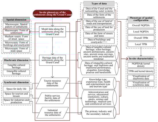
Figure 4.
Technical path of in-site phenotype of the settlement space along China’s Grand Canal.
4. In-Site Phenotype of the Settlement Space along Tianjin Section
4.1. In-Site Phenotype of the Settlement Space in Grain Transporting Dominant Type
4.1.1. Spatial Configuration Phenotype of the Settlement Space in Grain Transporting Dominant Type
Settlements of the grain transporting dominant type included Pangzui, Laomidian, Majiakou, Jinguantun, and Dongxicang villages (Table 3 and Figure 5). (1) In terms of the overall NQPDA, the mean value of the settlements of Laomidian and Jinguantun was relatively higher, 1.55 and 1.06, respectively, compared to that of Pangzui and Majiakou, which were 0.84 and 0.95, respectively, and that of Dongxicang was the lowest, 0.60. The settlements of Laomidian and Jinguantun boasted strong accessibility, the core space of Pangzui and Majiakou lay inside settlements influenced by river terrain and the spatial structure of Dongxicang was simple, while its core roads were linked with Caizhuang in the north. (2) As to the local NQPDA, the distribution of the five high-value settlements was connected with the spatial form. Pangzui and Laomidian displayed a linear structure parallel with the canal, Maojiakou had a cohesive axis-shaped structure, and Jinguantun and Dongxicang had a dual core cohesive structure vertical to the canal. (3) As to the overall TPBt, the structures of the vital communication lines of trafficability characteristics and the roads of high overall TPBt were consistent in the five settlements, representing the main communication lines to the settlements. (4) As to the local TPBt, high-value streets and lanes were scattered in the core zone of settlements, which were the main functional places of daily activities of villagers.
Table 3.
GIS-SDNA syntactic parameters of the settlement space in grain transporting dominant type.
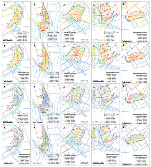
Figure 5.
Spatial configuration analytical result of the settlement space in grain transporting dominant type.
4.1.2. In-Site Characteristics of the Settlement Space in Grain Transporting Dominant Type
The analysis of the in-site characteristics of the settlement space for the grain transporting type shows that (Figure 6): (1) Pangzui was built according to the river terrain. In the shape of a mouth, it developed a unique settlement form. The overall proximity to Pangzui has a high relevance for data regarding public-service facilities and tourist resources. It was determined through the field investigation that Pangzui invited some artists to the village and built an art gallery and an exhibition center, and family remains to drive the development of the rural settlements. (2) Since ancient times, the pick-shaped Laomidian has been a ferry location for grain transportation. The topological central area and the areas of high-value trafficability characteristics have a high relevancy with public-service facilities and a low relevancy with cultural heritage and industrial resources. (3) As a typical case of a dredging intake channel, the overall proximity of Majiakou shows a spotty distribution and high-value space, and the public-service facility resources have high relevancy. High-value road networks comprise the main roads in the western and southern parts of the settlement. (4) The trapezoid-shaped Jinguantun used to house garrison troops. There are only a few public-service facilities in the high-value zones of the settlement. The proximity to Jiuxuanzha heritage and tourist resources are close. The in-site characteristics of high TPBt show the high trafficability characteristics of road networks in the settlement; the TPBt of the bridge in the west of the village and other high-value road networks have some relevance to tourist resources, public-service facilities, and Jiuxuanzha heritage. (5) In Dongxicang, as one of the fourteen “cang” villages, the high centrality of the area has the highest relevance to public-service facilities, followed by those of cultural heritage and industrial resources.
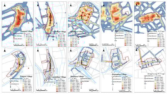
Figure 6.
GIS-sDNA analytical result of the in-site characteristics of the settlement space of the grain transporting dominant type.
4.2. In-Site Phenotype of the Settlement Space in Industry Dominant Type
4.2.1. Spatial Configuration Phenotype of the Settlement Space in Industry Dominant Type
The settlements of an industry dominant type included the Erdaojie of Duliu Town, Wangqinzhuang, Xiaoshawo, and Jizhuangzi (Figure 7 and Table 4). (1) The analytical results of the overall proximity showed that the overall mean values for the four rural settlements were Erdaojie of Duliu Town (of 3.80) > Wangqinzhuang (of 1.56) > Jizhuangzi (of 1.27) > Xiaoshawo (of 1.15), indicating that the accessibility of the entire space of typical rural settlements relating to industries was quite strong. Erdaojie of Duliu Town lies in Duliu Town and is densely dotted with road networks. The road networks with a high proximity are in a +-shaped distribution; the core zone of Wangqinzhuang could be divided into southern and northern parts with the core zone in the shape of a fishing net in the north and a grid in the south; Jizhuangzi and Xiaoshawo core zones were in a grid-shaped distribution. (2) The local proximity indicates that the local core zones of the four rural settlements were all in the center of the settlements and featured multi-core distributions. (3) The overall proximity displayed that the structure of the vital communication line with trafficability characteristics and that of some roads with high overall integration degree are basically consistent. The roads with trafficability characteristics in Erdaojie of Duliu Town, Xiaoshawo, and Jizhuangzi span over the canal, representing a high opening degree of space. (4) The structure of four streets with high local TPBt is like that of the local integration degree, displaying the characteristics of a discrete distribution.
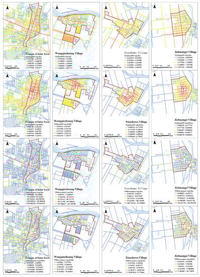
Figure 7.
Spatial configuration analytical result of the settlement space in the industry dominant type.
Table 4.
SDNA syntactic parameters of the settlement space in the industry dominant type.
4.2.2. In-Site Characteristics of the Settlement Space in Industry Dominant Type
The analysis of the in-site characteristics of the settlement space of the industry dominant type shows that (Figure 8): (1) Duliu Town has been a gathering place of merchants and has had wine and vinegar breweries since ancient times. As to the in-site characteristics of the proximity of the Erdaojie of Duliu Town, high-value zones are highly relevant, with cultural heritage resources such as the Zhang Family Residence, the Liu Family Residence, and the Tankou Historic Site. The phenotype of TPBt indicates that high-value areas have a high relevancy for public-service facilities. (2) Since ancient times, Wangqinzhuang has boasted advanced water transport and fisheries. Now, industries are mainly fruit-planting for orchards, vegetable planting, and processing. The in-site characteristics of proximity exhibit a central area with a high integration degree in the north of the village that has a high relevancy for public-service facilities. Meanwhile, there are also relations with three cultural heritage resources, namely, the Temple of the King of Medicine, the former residence of Huang Jinxiang, and Zhongyingshaolian Martial Art Society, manifesting that cultural and artistic activities are also in-site characteristics of Wangqinzhuang, showing that cultural and art activities are also in-site characteristics of the settlement. The high-value road networks are highly relevant to public-service facilities. (3) Xiaoshawo is rich in turnips and boasts many planting and marketing bases and advanced agriculture. The area of high overall proximity is of high relevance to public-service facility resources, low relevance to tourist resources and has the lowest relevance for industrial resources. The high-value road network is linked to the canal bridge and the rural highway and is the place where most people and vehicles travel. (4) Jizhuangzi is rich in “preserved, dried vegetables”. Pickles are the main source of finances of villagers. The in-site characteristics of the proximity shows that the high-value center is evenly distributed among the settlements. Two ancient tombs and former dwellings are located in the center of the area and public-service facility resources were in a linear distribution near the south–north road.
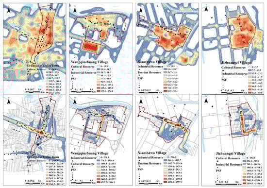
Figure 8.
GIS-sDNA analytical result of the in-site characteristics of the settlements of the industry dominant type.
4.3. The In-Site Phenotype of the Settlement Space in History Dominant Type
4.3.1. Spatial Configuration Phenotype of the Settlement Space in History Dominant Type
The typical settlements in terms of the history dominant type include Xidiaotai, Zhouyangzhuang, Kuangergang-Gangbeixin-Nanxinzhuang, and Dalongzhuang (Figure 9 and Table 5). (1) The overall NQPDA showed that the overall mean values of the six rural settlements were in the sequence of Xidiaotai (of 1.68) > Kuangergan-Gangbeixin-Nanxinzhuang (of 1.04) > Zhouyangzhuang (of 0.81) > Dalongzhuang (of 0.51). The Xidiaotai core zone is in a grid distribution, Zhouyangzhuang in an axis-shaped distribution and the Kuangergang-Gangbeixin-Nanxinzhuang core zone with Nanxinzhuang as the core is in a grid-shaped distribution. Dalongzhuang has small-scale features a low proximity and high-value structures are in a cross-shaped distribution. (2) The analytical result of the degree of local integration shows that most of the six core zones of the six rural settlements lie in the center of the settlements. (3) The overall TPBt indicates that the overall TPBts of Xidiaotai and Kuangergang-Gangbeixin-Nanxinzhuang are higher; both villages have bridges over the canal and higher space exploitation degrees. (4) In terms of local TPBt, the road network with a high local TPBt value in all six villages is approximate to the local integration degree and in the discrete distribution.
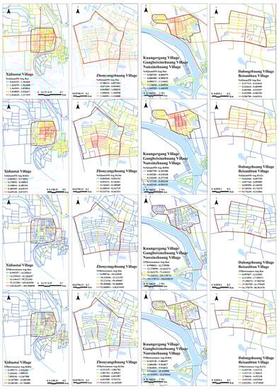
Figure 9.
Spatial configuration analytical result of the settlement space in the history dominant type.
Table 5.
SDNA syntactic parameters of the settlement space in the history dominant type.
4.3.2. In-Site Characteristics of the Settlement Space in History Dominant Type
The analysis of the in-site characteristics of a settlement space of the history dominant type shows (Figure 10) that: (1) Xidiaotai boasts a long history, with connections to Dongpingshu Historical Town of the Western Han Dynasty and the legend of Jiang Taigong Fishing. From the perspective of the in-site phenotype of proximity, the high-value center lay to the northeast of the canal and only a small number of commercial facilities were found there. The high trafficability network mainly covers the Dongdiaotai Bridge and Xidiaotai Bridge and the roads in the northern and western parts of the settlements have a high relevance for industrial resources. (2) Zhouyangzhuang is reputed as the “No.1 Village of Ethnic Groups in Tianjin” with Hexiwu Mosque rebuilt on ruins that were originally constructed in the Ming Dynasty. As to the in-site phenotype of proximity, an enormous number of public-service facilities were distributed in the area of high centrality, including the majority of commercial facilities. The area of high trafficability was distributed as arterial traffic in the east and south and has high relevance for Hexiwu Mosque and some commercial service facilities. (3) Kuangergang, Gangbeixin, and Nanxinzhuang are close to the Kuangergang Hub of the north canal. The imperial monument “Dao Liu Ji Yun” erected by Emperor Kangxi is found there. The central area of high value is in the settlements to the north, and have relevance for some public-service facilities and a low relevance for tourist resources of farm yards. Road sections with high trafficability characteristics are of a high relevance to arterial traffic and tourist resources. (4) Dalongzhuang used to be the mansion of the marquis of the Yang family. Later, the tenants of the Yang family scattered around Dalongzhuang, which became a natural village. The area with a high centrality value in the settlements is at the former sites of the mansion of the marquis and the Phoenix Platform, and is now primarily a residential space. An area of high TPBts comprised the roads in the center and south of the settlement, and was of high relevance to public-service facilities.
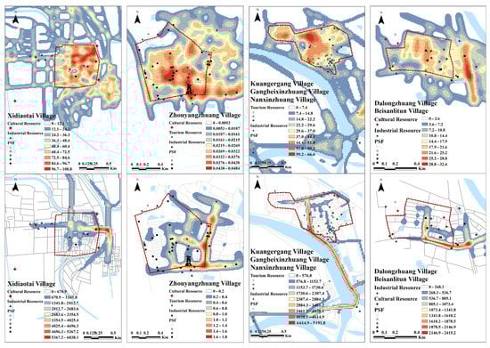
Figure 10.
GIS-SDNA analytical result of the in-site characteristics of the settlement space in the history dominant type.
4.4. In-Site Phenotype of the Settlement Space in Folk Customs Dominant Type
4.4.1. Spatial Configuration Phenotype of the Settlement Space in Folk Customs Dominant Type
The settlements for the folk customs dominant type consist of Sigezhuang, Wangqinzhuang, Yangliuqing Historical Town, and Beisanlitun (Figure 11 and Table 6). (1) As to the overall integration degree, the overall mean values of the three rural settlements are in the sequence of Yangliuqing Historical Town (of 1.50) > Sigezhuang (of 1.16) > Beisanlitun (of 0.51). The main rural roads are evenly distributed in the overall core zone of Sigezhuang, and are in a square grid layout, covering the whole settlement space and featuring excellent accessibility. Yangliuqing Historical Town comprises tourist streets and traditional settlements with a high-value road network in a circular distribution. Beisanlitun features the smallest scale, only two high-value trunk roads and connections with the main rural space. (2) The local integration degree indicates that the local core zones of the three rural settlements are of a cohesive uni-core structure. (3) The overall TPBt manifests in that the TPBt of Yangliuqing Historical Town is the highest and the roads with trafficability characteristics are connected to historical blocks, traditional settlements, roads to the canal used by emperors, and the trunk roads in the historical town; the structures or roads with trafficability characteristics in Sigezhuang are have an overall integration degree, mainly distributed around the settlement with a road running through the core zone of the village; the overall TPBt of Beisanlitun is low, indicating that the rural settlements are close. (4) The local TPBt manifests in that the roads with a high local trafficability value for the three villages are similar to the local structures with some integration degree.
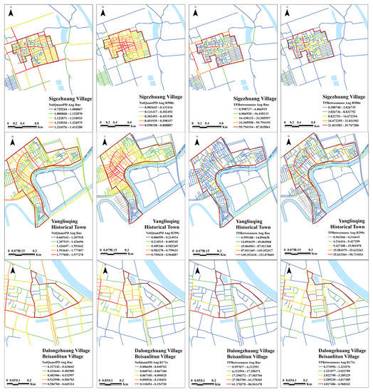
Figure 11.
SDNA analytical result of the settlement space in the folk customs dominant type.
Table 6.
SDNA syntactic parameters of the settlement space in the folk customs dominant type.
4.4.2. In-Site Characteristics of the Settlement Space in Folk Customs Dominant Type
The analysis of the in-site characteristics of the settlement space in the folk customs dominant type shows that (Figure 12): (1) The in-site characteristics of Sigezhuang shows that the high-value areas lie in the northwest and have a high relevance tp public-service facilities and the intangible Bamboo Hobbyhorse Society cultural heritage site, as well as such cultural heritage sites as the Temple of Local God of the Land and the Temple of Master. The high-value road network comprises arterial traffic to enter the settlements and has a high relevance to public-service facilities. (2) Yangliuqing Historical Town was established in the Jin Dynasty and was the hub of grain transport and a gathering place for merchants in the Ming and Qing Dynasties, featuring great cultural diversity. From the point of view of in-site characteristics, high-value settlements have a high relevance to available public-service facilities, cultural heritage resources, and tourist and landscape resources. Tourist attractions boast abundant resources despite weak topological integration. (3) Beisanlitun was the garrison of the “2nd Garrison Troop” in the Yuan Dynasty and was established by Yuan troops to open up land for waste and to grow food grain. “Male and Female Brothers of Liu Xiaoguan”, a storytelling script adapted from a strange tale in the village from famous storytelling script writer Feng Menglong of the Ming Dynasty, is still popular today. As to the in-site characteristics, the central area has a high value and primarily covers roads leading to the village and some residential space in the west of the village. There are a few public-service facilities in the village. From the perspective of the in-site phenotype of the TPBt, the eastern and western roads linking Beisanlitun and Dalongzhuang are high-value areas with a relevance for public-service facilities and industrial resources.
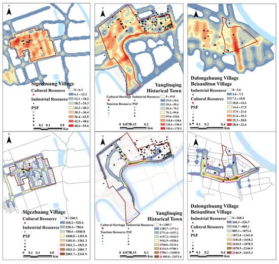
Figure 12.
GIS-sDNA analytical result of the in-site phenotype results of the settlement space in the folk customs dominant type.
5. Discussion
5.1. In-Site Characteristics of the Settlements along Tianjin Section
Comparative analysis of the phenotype values of the overall proximity configuration shows (Table 7) that the value of the spatial configurations of settlements in the industry dominant type was 2.05, followed by 1.07 in the history dominant type, 1.06 for that in the folk customs dominant type and 0.92 for that in the grain transporting dominant type. Comparative analysis of the phenotype value of the overall TPBt configuration showed that the value of the spatial configurations of all kinds of settlements were, from high to low, 30.22 for the industry dominant type, 19.55 for the history dominant type, 17.27 for the folk customs dominant type, and 17.22 for the grain transporting dominant type. The research shows that the comparison results of the overall through-movement and the overall proximity were similar. The dynamics of the settlements in the industry dominant type were higher, the topological integration capacity and attraction of the central area of the settlements were stronger, and the data of the areas with high trafficability characteristics were greater. On the one hand, as important posts of commerce and trade and water transport terminals, the patterns from Erdaojie of Duliu Town and Wangqinzhuang were complete and the spatial configurations could reproduce the advanced in-site characteristics of industries. On the other hand, with the decline in the functions of grain transport, the disappearance of large quantities of native heritage and the influence of urbanization, settlements, such as the former ferries, wharves, irrigation and dredging channels, warehouses, gentry posts, garrison, and courier stations for grain transport, have accordingly lost their status.
Table 7.
Summary and comparison of the spatial configuration of the rural settlements along China’s Grand Canal Tianjin Section.
The phenotype values of local proximity configurations show that the value of the spatial configurations of different types of settlements are, from high to low, 0.52 for the industry dominant type, 0.32 for the folk customs dominant type, 0.29 for the grain transporting dominant type, and 0.21 for the history dominant type. The comparative analytical results of the in-site phenotypes are similar. The dynamic scope of the settlements is highly related with the data of public-service facilities, somewhat related with the data of cultural heritage and tourist resources, and poorly related with that of industrial resources.
5.2. In-Site Genes of the Settlements along Tianjin Section
In-site genes represent the formation mechanism of the spatial characteristics particular to an area and is the fundamental reason for regional differences and diversities. The above analysis shows that settlements along the canal boast multiple, causal, and blended in-site phenotypes. (1) Multiplicity—the origin of the rural settlements—had direct relations with the status of grain transporting; the development of grain transporting expedited the industrial prosperity of rural settlements. Therefore, the in-site attributes of the rural settlements under the effects of multiple in-site rules boast the inherent law of multiple genes. (2) Reciprocal causation—rural settlements prospered with the prosperity of the canal and became ordinary with its decline. The water system along the Tianjin Section is large in the north and small in the south, showing a mild terrain difference. The water environment stood as a prominent problem for long water shortages in the south canal in Jinghai District. With the decline of grain transporting and the rise of rail transportation, some settlements along the canal gradually declined. (3) Blending: the settlements were a material representation of the politics, economy, society, and culture over the course of historical development. The prosperity of grain transportation was the direct reason for the development of settlements along the canal and gave rise to the diverse and characteristic culture. The culture of grain transporting was the dominant culture of the settlements along the Tianjin Section and the diverse culture of Tianjin and the immigrant culture, marine culture, Mazu culture, commercial and trade culture, as well as folk culture, brought by grain transportation composed the blended in-site characteristics of the settlements in Tianjin.
6. Conclusions and Prospects
The paper applied GIS-sDNA software to quantitatively analyze the spatial configuration phenotypes and the in-site characteristics of 18 typical rural settlements along China’s Grand Canal Tianjin Section and determined the different types of dynamic scope of the settlements. Overlapping analysis was conducted for data regarding cultural heritage, tourist resources, public-service facilities, spatial models and spatial configuration density of the settlements in the context of historical, synchronic and spatial dimensions so as to explore the phenotype and rules of the in-site genes of rural settlements along the Tianjin Section. Research found that the settlements there can be divided into 16 sub-types of four major categories. Among these, settlements in the industry dominant type, especially for commerce and trade exchange, featured higher dynamics and a stronger integration capacity of settlements; the core zones in the settlements showed high relevance to public-service facilities, some relevance for cultural heritage and tourist resources and the lowest relevancy with industrial resources. The settlements along the Tianjin Section feature multiple, causal, and blended in-site phenotypes. The research results provided new standards to categorize these settlements, new paths and methods to extract their in-site characteristics, new cognitive perspectives for conservation, and new theoretical support to conserve and renew these settlements. The present research results can enrich the cultural heritage resources of China’s Grand Canal and it is suggested to use in research on settlements of canals in other areas to help extract the in-site characteristics of those settlements, clarifying the advantages of cultural resources, help with conservation, development, and management of the cultural heritage of those settlements and further prove the significance and value of this research in practice.
The research analyzed the macroscopic characteristics of settlements along the Tianjin Section. In the future, microscopic quantitative analysis of the in-site characteristics of the streets, lanes, and courtyards in these settlements can be made to explore the in-site language and spatial genes. In the future, the in-site development of these settlements can be researched according to the following aspects: (1) To conserve, inherit, and develop the settlements along the Tianjin Section, efforts should be made to give scope to in-site collaboration of the local management departments of all sections and strengthen the top-level management mechanisms. In-site evaluation should be made of settlements to clarify the in-site attributes of the settlements, influenced by multiple in-site laws, and establish an inheritance system of in-site phenotypes. (2) On the basis of repairing the ecological corridor of China’s Grand Canal, efforts should be made to make use of the functions of the settlements in the context of the cavernous body, integrating the green corridor, parks, and water systems of the canal into the settlements, and setting up an ecological security pattern for the settlements. (3) Extract the in-site genes from the perspectives of regional spaces, settlements, street and lane spaces, building spaces and environmental spaces, and form the technological mapping of an in-site creation of settlements along the Tianjin Section. (4) Strengthen thought of in-site development of settlements featuring “integration of culture and tourism”, and designing high-quality routes of different themes and categories, implementing the development of characteristic towns and villages and invigorate the living, ecological, cultural and industrial spaces of towns and villages.
Author Contributions
Conceptualization, Y.Z., J.-W.Y. and G.-M.B.; methodology, Y.Z. and Y.L.; software, Y.Z.; validation, Y.L., G.-M.B. and Y.L.; formal analysis, Y.L. and G.-M.B.; investigation, Y.Z., Y.-Z.D. and G.-M.B.; resources, Y.Z. and Y.-Z.D.; data curation, G.-M.B.; writing—original draft preparation, Y.Z.; writing—review and editing, G.-M.B.; visualization, Y.Z. and G.-M.B.; supervision, J.-W.Y.; project administration, J.-W.Y.; funding acquisition, Y.Z. All authors have read and agreed to the published version of the manuscript.
Funding
The paper is a phased achievement of the Tianjin Art Planning Project (E18007), National Undergraduate Training Programs for Innovation and Entrepreneurship (202114038004 and 202114038008) and Tianjin Ren’ai College Scientific Research Project (XX18004).
Institutional Review Board Statement
Not applicable.
Informed Consent Statement
Not applicable.
Data Availability Statement
Data derived from the current study can be provided to readers upon request.
Acknowledgments
This paper was financially supported by the Tianjin Art Planning Project (E18007), National Undergraduate Training Programs for Innovation and Entrepreneurship (202114038004 and 202114038008) and Tianjin Ren’ai College Scientific Research Project (XX18004). The authors are grateful to Hengyu Gu for the support on the spatial syntax technology he provided.
Conflicts of Interest
The authors declare no conflict of interest.
References
- Malaterre, P.; Rogers, D.C.; Schuurmans, J. Classification of Canal Control Algorithms. J. Irrig. Drain. Eng. 1998, 124, 3–10. [Google Scholar] [CrossRef] [Green Version]
- Boughriet, A.; Proix, N.; Billon, G. Environmental Impacts of Heavy Metal Discharges from a Smelter in Deûle-canal Sediments (Northern France): Concentration Levels and Chemical Fractionation. Water Air Soil Pollut. 2007, 180, 83–95. [Google Scholar] [CrossRef]
- Ingersoll, C.G.; MacDonald, D.D.; Brumbaugh, W.G. Toxicity assessment of sediments from the Grand Calumet River and Indiana Harbor Canal in Northwestern Indiana, USA. Arch. Environ. Contam. Toxicol. 2002, 43, 156–167. [Google Scholar] [CrossRef]
- Mekonnen, D.; Siddiqi, A.; Ringler, C. Drivers of groundwater use and technical efficiency of groundwater, canal water, and conjunctive use in Pakistan’s Indus Basin Irrigation System. Int. J. Water Resour. Dev. 2016, 32, 459–476. [Google Scholar] [CrossRef]
- Müller, J.C.; Dennis, H.; Alfred, S. Canal construction destroys the barrier between major European invasion lineages of the zebra mussel. Proc. R. Soc. B Biol. Sci. 2002, 269, 1139–1142. [Google Scholar] [CrossRef] [Green Version]
- Biscaya, S.; Elkadi, H.A. Smart ecological urban corridor for the Manchester Ship Canal. Cities 2021, 110, 103042. [Google Scholar] [CrossRef]
- Flemsæter, F.; Stokowski, P.; Frisvoll, S. The rhythms of canal tourism: Synchronizing the host-visitor interface. J. Rural Stud. 2020, 78, 199–210. [Google Scholar] [CrossRef]
- Wang, X.; Han, J.; Xu, L.; Zhang, Q. Spatial and seasonal variations of the contamination within water body of the Grand Canal, China. Environ. Pollut. 2010, 158, 1513–1520. [Google Scholar]
- Wang, X.; Han, J.; Xu, L.; Zhang, Q. Effects of anthropogenic activities on chemical contamination within the Grand Canal, China. Environ. Monit. Assess. 2011, 177, 127–139. [Google Scholar] [CrossRef]
- Fu, C.L. The History of Canal Cities in China. In Development History of Canal Cities in China; Sichuan People’s Press: Chengdu, China, 1985; Volume 11, pp. 58–68. [Google Scholar]
- Lin, C.L. Grain transporting and the rise of Tianjin commercial city in Ming Dynasty. Tianjin Soc. Sci. 1984, 10, 85–91. [Google Scholar]
- Yang, J.J.; Guo, L.X. Study on urban redevelopment planning along the canal in Hangzhou. City Plan. Rev. 2001, 25, 77–80. [Google Scholar]
- Li, C.B.; Zhu, Q. Research on the Width of Canal Heritage Corridor Based on Heritage Distribution-Taking Tianjin canal as an example. Urban Probl. 2007, 146, 12–15. [Google Scholar]
- Chen, W. Walking on the Canal Line, a Study of the Historical Cities and Architecture along the Great Canal; China Architecture & Building Press: Beijing, China, 2014. [Google Scholar]
- Zhao, X. The Comprehensive Protection Approach for the Grand Canal Settlements in North Zhejiang Province based on the Concept of Historic Urban Landscape: A Case Study of Jiaxing. Urban Dev. Stud. 2014, 21, 37–43. [Google Scholar]
- Cheng, Z.F.; Tang, S.Y.; Hua, H.L. A Study of Cognition and Identification of the Grand Canal Culture from the Perspective of Traditional Village Residents in Beijing-The Cases of Three Traditional Villages in Tongzhou. J. Beijing Union Univ. 2018, 16, 36–46. [Google Scholar]
- Duan, J.; Yin, M.; Tao, A.J. “In-site” Protection: Cognitive Turn of Characteristic Towns and Villages Protection and Conservation, Implementation Approaches and Institutional Recommendations. Urban Plan. Forum 2021, 2, 25–32. [Google Scholar]
- Hillier, B.; Hanson, J. The Logic of Space. In The Social Logic of Space; Cambridge University Press: Cambridge, UK, 1984; pp. 52–66. [Google Scholar]
- Ding, C.B.; Gu, H.Y.; Tao, W. Progress in the Application of Space Syntax in Human Geography Research in China. Trop. Geogr. 2015, 35, 515–521. [Google Scholar]
- Hillier, B.; Hanson, J.; Graham, H. Ideas are in things: An application of the space syntax method to discovering house genotypes. Environ. Plan. B Plan. Des. 1987, 14, 363–385. [Google Scholar] [CrossRef] [Green Version]
- Hanson, J. Tradition and Change in the English House. In Decoding Homes and Houses; Cambridge University Press: Cambridge, UK, 1998; pp. 56–78. [Google Scholar]
- Shokouhi, M. Legible Cities: The Role of Visual Clues and Pathway Configuration in Legibility of Cities. In Proceedings of the 4th International Symposium on Space Syntax, London, UK, 1 June 2003. [Google Scholar]
- Hillier, B.; Penn, A.; Hanson, J.; Grajewski, T.; Xu, J. Natural Movement: Or, Configuration and Attraction in Urban Pedestrian Movement. Environ. Plan. B Plan. Des. 1993, 20, 29–66. [Google Scholar] [CrossRef] [Green Version]
- Hillier, B.; Hanson, J.; Peponis, J. Syntactic Analysis of Settlements. Archit. Behav. 1987, 3, 217–231. [Google Scholar]
- Hillier, B. A theory of the city as object: Or, how spatial laws mediate the social construction of urban space. Urban Des. Int. 2002, 7, 153–179. [Google Scholar] [CrossRef] [Green Version]
- Hillier, B. The Knowledge that Shapes the City: The Human City Beneath the Social City. In Proceedings of the 4th International Space Syntax Symposium, London, UK, 1 June 2003. [Google Scholar]
- Read, S. Space syntax and the Dutch city. Environ. Plan. B Plan. Des. 1999, 26, 251–264. [Google Scholar] [CrossRef]
- Barkat, I.; Ayad, H.; Elcherif, I. Detecting the physical aspects of local identity using a hybrid qualitative and quantitative approach: The case of Souk Al-Khawajat district. Alex. Eng. J. 2019, 58, 1339–1352. [Google Scholar] [CrossRef]
- Wernke, S.A. Spatial network analysis of a terminal prehispanic and early colonial settlement in highland Peru. J. Archaeol. Sci. 2012, 39, 1111–1122. [Google Scholar] [CrossRef]
- Kim, Y.O.; Penn, A. Linking the spatial syntax of cognitive map to the spatial syntax of the environment. Environ. Behav. 2004, 36, 483–504. [Google Scholar] [CrossRef]
- Wang, H.F. The dynamic relationship between social function and space and the morphological evolution of Huizhou traditional villages. Architect 2008, 2, 23–30. [Google Scholar]
- Tao, W.; Lin, K.F.; Gu, H.Y.; Liao, C.M.; Liu, S.Y.; Ou, Q.Y. Spatio-Temporal Evolution of Shawan Ancient Town in Guangzhou from the Perspective of Spatial Syntax. Trop. Geogr. 2020, 40, 970–980. [Google Scholar]
- Cooper, C.H.V.; Chiaradia, A.J.F. SDNA: 3-d spatial network analysis for GIS, CAD, Command Line & Python. SoftwareX 2020, 12, 100525. [Google Scholar]
- Cooper, C.H.V. Predictive spatial network analysis for high-resolution transport modeling, applied to cyclist flows, mode choice, and targeting investment. Int. J. Sustain. Transp. 2018, 12, 714–724. [Google Scholar] [CrossRef] [Green Version]
- Kang, C. Measuring the effects of street network configurations on walking in Seoul, Korea. Cities 2017, 71, 30–40. [Google Scholar] [CrossRef]
- Ye, Y.; Li, D.; Liu, X. How block density and typology affect urban vitality: An exploratory analysis in Shenzhen, China. Urban Geogr. 2018, 39, 631–652. [Google Scholar] [CrossRef]
- Ye, Y.; Yeh, A.; Zhuang, Y.; van Nes, A.; Liu, J. “Form Syntax” as a contribution to geodesign: A morphological tool for urbanity-making in urban design. Urban Des. Int. 2017, 22, 73–90. [Google Scholar] [CrossRef]
- Gu, H.Y.; Huang, D.; Shen, T.Y. Space Syntax Model Verification and Application in Urban Design with Multi-source Data. Planners 2019, 35, 67–73. [Google Scholar]
- Shao, R.Q.; Duan, J.; Qian, Y. Spatial Genes: New Approach of Planning and Design for Local Memory—A Case Study of the Former Capital Airport of the Republic of China in Nanjing. Planners 2020, 36, 40–46. [Google Scholar]
Publisher’s Note: MDPI stays neutral with regard to jurisdictional claims in published maps and institutional affiliations. |
© 2022 by the authors. Licensee MDPI, Basel, Switzerland. This article is an open access article distributed under the terms and conditions of the Creative Commons Attribution (CC BY) license (https://creativecommons.org/licenses/by/4.0/).