Abstract
At the beginning of human history, surface water, especially from rivers and springs, was the most frequent water supply source. Groundwater was used in arid and semi-arid regions, e.g., eastern Crete (Greece). As the population increased, periodic water shortages occurred, which led to the development of sophisticated hydraulic structures for water transfer and for the collection and storage of rainwater, as seen, for example, in Early Minoan times (ca 3200–2100 BC). Water supply and urban planning had always been essentially related: the urban water supply systems that existed in Greece since the Bronze Age (ca 3200–1100 BC) were notably advanced, well organized, and operable. Water supply systems evolved considerably during the Classical and Hellenistic periods (ca 480–31 BC) and during the Roman period (ca 31 BC–480 AD). Also, early Indian society was an amazing vanguard of technology, planning, and vision, which significantly impacted India’s architectural and cultural heritage, thus laying the foundation for sustainable urban living and water resource management. In ancient Egypt, the main source of freshwater was the Nile River; Nile water was conveyed by open and closed canals to supply water to cities, temples, and fields. Underground stone-built aqueducts supplied Nile water to so-called Nile chambers in temples. The evolution of water supply and urban planning approaches from ancient simple systems to complex modern networks demonstrates the ingenuity and resilience of human communities. Many lessons can be learned from studying traditional water supply systems, which could be re-considered for today’s urban sustainable development. By digging into history, measures for overcoming modern problems can be found. Rainwater harvesting, establishing settlements in proximity of water sources to facilitate access to water, planning, and adequate drainage facilities were the characteristics of ancient civilizations since the ancient Egyptian, Minoan, Mohenjo-Daro, Mesopotamian, and Roman eras, which can still be adopted for sustainability. This paper presents significant lessons on water supply around the world from ancient times to the present. This diachronic survey attempts to provide hydro-technology governance for the present and future.
1. Prolegomena
By studying ancient civilizations, we study ourselves and learn from the past about the present and the future.(Andreas N. Angelakis)
Cities emerge and develop as a result of the interaction between natural environmental factors, such as locations, climates, soils, vegetation, hydrographic and geomorphologic conditions, and the cultural, economic, and social levels of development of resident populations []. Cities are defined as areas with high human density; the urban environment (the area in which a city is located) ultimately defines a city’s potential extension, depending on available natural resources. They impact their distribution and growth and conditions of their vocations (industrial, cultural, commercial, service) according to their particular historical moment []. During each of these phases, the only common feature may be their positioning according to the presence of water. Almost every community, in fact, from the first nomadic communities to modern agglomerations, has settled on the banks of rivers and lakes or near groundwater springs. Water sources were so important in history that they played an important role in topology: Şanlıurfa (Turkey), for example, situated on a plain about 80 km east of the Euphrates, was known throughout history by various names, the oldest being “Urhay”, “Urfa”, and “Ruha” and then Edessa in Hellenistic and Christian times, all of which had the meaning of “city near the water” or “tower in the water” []. The city of Gaziantep’s (Turkey) name comes from “Ayntâb”, which means “The City of Springs”. Rome contains the Etruscan root “Rumon”, which means river, indicating a city established on a river. Among many others around the world, cities such as Van, Sakarya, Bartın, Burdur, Karasu, Aksu (Antalya), Beyşehir (Konya), Paranà (Argentina), Winnipeg (Canada), Salt Lake City (USA) and Managua (Nicaragua) got their names from the water springs near where they are located []. The city of Milwaukee (USA) derives its name from the Potawatomi Indian word “minwaking”, which means “gathering place by the waters”.
As “water” is the most important element of human life, hydraulic engineering must ensure the local availability of this resource. Population growth and urbanization result in significant alterations to natural hydrologic processes, environmental quality, and natural resource consumption; therefore, protection and sustainable use of water resources are crucial to continuing development []. It could be easily stated that hydraulic engineers had as important a role in the foundation and development of cities as architects of buildings.
In the planning of today’s cities, rivers and streams play an essential role in urban (re)design, the development of recreational or urban nature protection areas, and the regulation of urban ecology []. As in the past, modern urban planning considers the relationship between the built environment and water to a high degree. Urban redevelopment often becomes an opportunity to revitalize urbanized or degraded rivers and seeks a variety of ecological, social, and economic benefits, ranging from improved flood management to increased ecosystem resilience [].
The world population is increasing rapidly and is expected to reach 9.5–10 billion people by 2050. More than 50% of the world’s population lives in urban areas, and this percentage will continue to rise. However, the universal supply of drinking water has not yet been achieved, even in developed countries, and it is the objective of current global efforts, such as the UN’s Sustainable Development Goals (SDG 6). Strained urban water infrastructure systems lead to vulnerability and unsustainability in both resource quality and quantity demand []. Water supply and management are, therefore, of great importance in urban planning and require innovative, sustainable approaches [].
Water supply systems are a key element in the provision of drinking water in the required quantity and quality. Water quality strongly depends on raw water sources, although modern treatment possibilities are now conductive to any desirable uses []. Traditional methods of water conservation and restoration are a collective form of information, knowledge, practices, and symbols, which have been established and preserved by societies throughout a long history of interaction with the natural environment. Many archaeological findings have shown that water conservation was an integral part of science in the ancient world. To improve urban planning and water supply, an analysis of the challenges and experiences of the past plays an important role in the integration of traditional and modern approaches to better serve society in a sustainable and technology-friendly way.
Even in modern times, water crises in large cities are not unheard of. Resource mismanagement in highly populated cities may set the ground for possible “Day Zero” events (i.e., a condition whereby water use is restricted to vital services) in infrastructural settings ill-equipped to deal with severe water scarcity. Two recently reported examples are emblematic: 2017’s Cape Town (South Africa) and 2015’s São Paulo (Brazil) water crises []. Notwithstanding the paramount role of technology, water resources are still nature-dependent, and their use should be planned according to the principles of sustainability and resilience to ensure their constant availability and efficient use throughout the year.
To improve our knowledge of the causes, events, and consequences of water crises and avoid future problems and challenges of urbanization by improving the framework for appropriate water management, it is necessary to provide a comprehensive overview of the history of urban planning and water supply. Study history if you want to define the future (Confucius, 551–479 BC).
The current challenge, closely related to the UN SDGs, is to develop appropriate methodological, scientific, technical, and institutional developments through capacity building, respond to natural and anthropic pressures, and carefully improve the way urban water systems are designed and managed.
This paper is organized as follows: Section 1 Prolegomena is an introduction to the topic and the elements of the study, followed by Section 2, Section 3 and Section 4, which explain the different histories of urban planning and water supply from the prehistoric era to the present in a geographical and chronological perspective, including the different types of technologies and water sources used. Section 5 is referred to the knowledge transfer and technological exchange in water management. Section 6 presents emerging trends and possible future challenges. Finally, Section 7 is the epilogue with concluding remarks and highlights.
2. Prehistoric to Medieval Times (ca 10,000 BC–1350 AD)
In the pre-classical and classical periods, Neolithic conurbations in Mediterranean and Middle Eastern places were laid out according to fixed plans. Thereafter, this became a common characteristic of Minoan, Mesopotamian, Harappan (also known as Indus Valley), and Egyptian civilizations of the third millennium BC. The first recorded description of urban planning appears in the Epic of Gilgamesh [], a Mesopotamian poem describing the feats of the Sumerian king.
2.1. Prehistorical Time in Anatolia (ca 10,000–1200 BC)
Due to its geographical location and its favorable climate, Anatolia was a place where traces of human presence could be found since the Paleolithic Age. During this period, the inhabitants of Anatolia sought shelter in caves and subsisted primarily as hunter-gatherers. The first village settlements emerged during the Neolithic period; however, the Neolithic evolution proceeded differently in individual regions due to geographical factors. Socio-cultural developments during this period led to a sedentary lifestyle, with people cultivating crops, domesticating animals, and establishing permanent villages near water sources. The foundations of modern civilization were laid during this era. Subsequently, the Chalcolithic marked the transition from villages to cities, where this term not only stands for higher settlement density but also for the emergence of new forms of governance as well as non-farming bureaucratic and artisan classes. The Bronze Age is the emergence of city-states, which indicates a further development of social organization and governmental structures. The development of the first cities in Anatolia can be seen in three regions: Southeastern and Eastern Anatolia and the regions of Konya and Niğde belonging to Central Anatolia. “Konya Lake”, the “Lake Region”, and the nearby meadows became the central points of urbanization. Settlements in the hills of Hacılar and Kuruçay are the most important examples from this period [].
The oldest known and most populous settlement of its time is Chatalhoyuk (Çatalhöyük), within the borders of Konya, dating back to the early Neolithic (7400 BC), which is considered the first example of the transition from village to urban life. Buildings were constructed on top of each other over the millennia: excavations have unearthed 13 such layers. Superficial foundations were made of sun-dried clay and lime plaster; supporting pillars were made of wood, and roofs of pressed clay and reeds [].
Houses generally consisted of two rooms, a storeroom, a pantry, and a kitchen, with identical floor plans, and they had no windows and no doors: entering and exiting occurred through an opening in the roof. This layout created a defense mechanism against attacks: houses were closely built side by side, and there were no roads, city walls, or fortifications around the city []. Houses were built in terraces with radial planning around a hill, reaching heights of up to 20 m; this urban planning required special water management arrangements. Canals were constructed to meet water demand and drain excess water downhill and outside the settlement area []. During excavations, it was found that simple arches were built to draw water from the nearby streams to the site; these could be considered the oldest water structures in the world [].
The most important features of large cities in ancient western Minor Asia (Anatolia), such as Tralleis, Ephesus, Perge, and Hierapolis, were that they were located in coastal regions and were advanced in water extraction and utilization []. Water from distant sources was conveyed by gravity, with open channels, tunnels, and pipes, under a free-flow approach based on maintaining piezometric height. Earthen pipes (baked clay, called “künk”) with a wall thickness of 1–2 cm were often used as there was no or very little pressure. Another type of non-pressurized pipe was made from wooden trunks 2–3 m in length and 15–20 cm in diameter, which were hollowed out and turned into interlocking pipes. This practice was widespread in the Tokat region due to the presence of forests []. Ephesus and Şirince, some of the most important centers of antiquity, dating from around 6000 BC, supplied water into the city with aqueducts: some of the most famous were the Lysimachus, Aqua Throessitica, Pollio, Şirince, Sultaniye, Arition, and Değirmendere aqueducts. The Selenus aqueduct was an 8 km long terracotta pipes waterway that carried 10 L/s of water per second through an opening in the Şirince city wall to the east of Ephesus [,].
The shorter Derbentdere Marnas aqueduct, which was also used during the Ottoman period for the water supply of Ephesus, was 7 km long with a hydraulic capacity of around 20 L/s, cut through rocky terrain, and crossed the Marnas valley []. The Aqua Throessitica and Pollio aqueducts carried water to the city through a total of six bridges and seven rows of clay pipes. Water brought near the city by aqueducts was stored at higher levels than the city itself and distributed by gravity by separate conduits: one supplied water to theatres and monumental fountains; the second supplied water to street fountains; the third was intended for private consumers. Terracotta pipes transported clean water, and an underground sewage system running through the ancient city to the sea collected baths’ water [,,,,]. In the acropolis of Pergamon, water was stored in underground cisterns. In Çavuştepe in Eastern Anatolia, rock-carved cisterns were also found [].
2.2. Minoan and Mycenaean Civilizations (ca 3200–1100 BC)
The Minoans planned urban settlements that symbiotically adapted to the natural environment. As they ruled the seas and sailed long distances across the Mediterranean for trade (this period was referred to as Pax Minoica, Minoan peace), their cities did not require fortification walls []. This absence is evident in all palaces, cities, and other settlements discovered; in contrast, subsequent Mycenaean civilizations built “cyclopean” walls, fortresses, and military works. Papit [] compared Minoan settlements in Crete and identified a unifying pattern, defining several common basic characteristics of urban planning. These illustrate a very specific type of Minoan urban planning that began at least with Early Minoan (ca 3200–2650 BC) and extended to Late Minoan (ca 1400–1100 BC).
Bronze Age Minoans knew the basic principles of what we now call urban water supply technologies, as shown by characteristic examples of surviving hydraulic structures and associated water supply technologies on Minoan Crete. The focus of water management was on sustainable, safe, cost-effective, and environmentally friendly small-scale practices, which may still be relevant today, as several water supply practices of modern societies are not very different from Minoan times [,]. Water supply technology was also similar in Mesopotamia (modern-day Iraq, Kuwait, part of Iran, Syria, and Turkey), where, in addition to spring water supply, rainwater harvesting was adopted. Sumerians in southern Mesopotamia diverted watercourses, cultivated floodplains, and built dams with drainage channels and water distribution systems for agricultural irrigation []. Supply systems were well known in Minoan Crete, where the purposeful construction and operation of complete and functional water networks were discovered in Knossos palace and Tylissos city [,]. Based on their accomplishments, it can be assumed that Minoan engineers were well aware of basic hydrostatic principles (“communicating vessels”), exploited in the water supply of the Knossos palace through conduits fed by high elevation springs. This is suggested by an aqueduct, probably the first known, heading toward the palace from a spring in Mavrokolybos, which was 400 m southwest of the palace at an elevation of about 150 m and connected by a descending and rising profile. It appears, however, that the Minoans had only a vague understanding of the relationship between flow and friction (i.e., quantification of head loss) [,]. Thereafter, Mycenaeans (ca 1600–1100 BC) have built higher aqueducts for water supply, as that in Mycenaean Tiryns.
Technology for the collection and storage of surface and rainwater was highly developed: in places where there was no other source of water, rainwater was stored in cisterns. One of the earliest prehistoric cisterns on the island was found in the center of a pre-palatial house complex on a hill near Chamaizi, dating back to the early to middle Minoan period (between the third and second millennium BC). The dwellings were grouped around a small open courtyard with a deep, circular cistern carved into the rock, 3.5 m deep and 1.5 m in diameter, the upper part of which was lined with masonry [].
Cisterns from the Middle to Late Period were found in Myrtos-Pyrgos (Ierapetra), Archanes, and Zakros. In Myrtos-Pyrgos, one is located at the top of the hilltop settlement, and another larger one (volume of 66 m3) along its slope (Figure 1a) []. In Zakros palace, opposite the so-called “King’s Apartment”, the central courtyard led into a spacious hall known as the Hall of the Cistern (Figure 1b) [], dating to the Late Period (ca 1500 BC). This had a capacity of about 50 m3 with steps for cleaning and scooping and could probably also serve as a swimming pool or aquarium [].
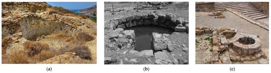
Figure 1.
Minoan cisterns: (a) At Myrtos-Pyrgos village in southeaster Crete; (b) “Hall of the Cistern” in the Palace at Zakros; (c) Cistern with coarse sand filter in Phaistos (with permission of A. N. Angelakis).
In Phaistos palace, rainwater was collected in cisterns. Special care was taken to ensure hygiene by cleaning open areas (e.g., courtyards and roofs) from which runoff was collected and by filtering the water in coarse sand filters before it flowed into the cisterns (Figure 1c) [,]. In addition to springs and rainwater, the Minoans exploited groundwater, especially in the semi-arid eastern regions of Crete. Several wells have been found in that area, including one near the southeastern corner of the central courtyard of Zakros palace; here, too, steps facilitate water abstraction. The fallen barrel of the windlass, along with a cup containing perfectly preserved olives and raisins, among other offerings, were found by archeologists at the well’s bottom [].
Water supply in Minoan Palaikastro city was also dependent on groundwater, and several wells with depths of 10 to 15 m have been discovered there []. One such well is shown in Figure 2. Other wells were found north of the Minoan “Villa of the Fountain Garden” at Amnissos, east of the city of Iraklion, which was probably built in the Early Late Period [].
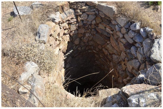
Figure 2.
Well in Palaikastro city (with permission of A. N. Angelakis).
The Minoans also developed technologies for the treatment of drinking water: since the Bronze Age (ca 3200−1100 BC), one of the salient characteristics of Minoan dwellings was the treatment of drinking water. Minoan engineers knew the most common methods of improving water quality for drinking supply: a curiously elongated water filter made of clay, known as Defner (Röthlein, Germany) (1921), was used for this purpose []. The device was constructed similarly to other ceramic materials. This was also used for the desalination of sea water by Minoan seafarers [].
2.3. Indus Valley Civilization (ca 3200–1300 BC)
In the 1920s, archeologists were impressed by the precise uniformity of Mohenjo-Daro’s building materials and architectural structures []. Most buildings were constructed of fired or unfired bricks standardized to approximately 6 × 12 × 24 cm in size; carefully constructed cylindrical structures with diameters of 0.60–2.4 m extending to a depth of over 18 m served as wells that provided access to groundwater within the city.
It is believed that Mohenjo-Daro had more than 700 such wells in its heyday, an unprecedented density for ancient cities. Each well in Mohenjo-Daro is estimated to have an average catchment radius of only 17 m. Their construction method is still the object of study: given the modest space available for the wells and their extraordinary depth, the only feasible construction method would have been “shaft sinking”, which involves layers of bricks on a stable wooden ring embedded in the ground. As the earth beneath the ring is removed and bricks are added on top of the others, the structure gradually sinks into the ground under its weight until it reaches water-bearing soil []. Whether this was the method used by the Harappan well builders still needs confirmation; however, regardless of the actual method, their construction represents a monumental feat of engineering at the time. The circular section, statically ideal for withstanding lateral pressures on deep shafts, was built out of wedge-shaped bricks, using the same principle of barrel vault construction []. Cylindrical brick-lined wells were likely an invention of the Indus people of the alluvial plain as no such wells have been discovered in pre-Harappan or early Harappan settlements or even in Mesopotamia and Egypt []. The real innovation in Mohenjo-Daro was the establishment of a network of urban water supply points that provided convenient access to water when needed, which could then easily be transported to the points of consumption.
Water use and sanitation were integral aspects of life in Mohenjo-Daro, with areas specifically dedicated to these functions. In almost every household, residents had access to what can be described as a bathroom: these spaces usually consisted of a shallow basin or platform of about 1 m2, constructed of sharp-edged bricks and connected to a street drain. Animal figurines were discovered in soak pits integrated into the houses’ drainage systems, suggesting possible ritual significance associated with these bathing facilities, with purposes likely beyond mere personal hygiene [].
The most famous water structure at Mohenjo-Daro was the Great Bath (Figure 3), considered to be the first known swimming pool in history, consisting of a rectangular brick tank of 160 m3 capacity, accessible by steps at each narrow end. The Great Bath symbolized the city’s reverence for water, an attitude shared with other early urban civilizations.
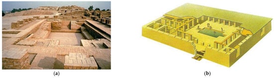
Figure 3.
Great Baths: (a) the Bath at Mohenjo-Daro; (b) a possible rendering of the Great Bath (http://www.bbc.co.uk/schools/primaryhistory/indus_valley/technology_and_jobs/, accessed on 20 January 2025).
Efficient disposal of wastewater reflected the sophistication of Mohenjo-Daro’s infrastructure: given the considerable water consumption by inhabitants, a disposal system was necessary []. In households, wastewater from bathing platforms and toilet drains flowed into collection tanks, which were often connected to a public sewer system. Used water from the Great Bath was channeled through a colossal 1.8 m high drain.
2.4. Ancient Egypt (ca 3100–30 BC)
The sophisticated urban planning and water management systems of ancient Egypt were pivotal in the development of one of history’s most enduring civilizations. Strategic urban layouts, monumental architecture, and advanced irrigation techniques enabled the Egyptians to thrive in their environment. These systems not only supported their daily lives and agricultural practices but also reinforced the social and political structures that defined ancient Egyptian culture. The legacy of these innovations continues to influence contemporary urban planning and water management practices.
During the pre-dynastic period (ca 3100 BC), early urban settlements began to form along the Nile, establishing foundational social and political structures. The Old Kingdom saw the development of centralized administrative cities. The Middle Kingdom marked a phase of political stability and economic prosperity, leading to the expansion and enhancement of urban centers. The New Kingdom, the zenith of Egyptian power, was characterized by large-scale building projects and the establishment of Thebes as a major city. In the Late Period, despite political decline and foreign domination, significant urban development continued. The Ptolemaic Period introduced Greek influences, which brought new architectural styles and urban layouts, with Alexandria emerging as a major center of culture and learning [].
Egyptian cities were strategically located along the Nile River, leveraging its resources and strategic opportunities; the layout of residential areas and public spaces typically featured an organized around temples and administrative buildings, reflecting the central role of religion and governance. Thebes, known for its temples and royal necropolis, including the Valley of the Kings, was a spiritual and political hub. Memphis, the administrative and cultural capital during the Old Kingdom, was home to the pyramid complexes at Giza. Alexandria, founded by Alexander the Great, became a hub of Hellenistic culture and learning []. The Nile River was the lifeblood of ancient Egyptian civilization, and its annual flooding was crucial for agriculture. The Egyptians harnessed this through an extensive network of canals, basins, and levees, which allowed them to control and distribute flood water effectively. This system ensured that water reached fields far from the river, enhancing agricultural productivity and sustaining the population [].
Irrigation techniques were advanced for the time. Egyptians used shadufs, hand-operated devices for lifting water, to manage water efficiently []. The shaduf consists of a long pole with a bucket at one end and a counterweight at the other, balanced on a vertical support, allowing for the easy transfer of water to higher ground or irrigation channels (Figure 4).
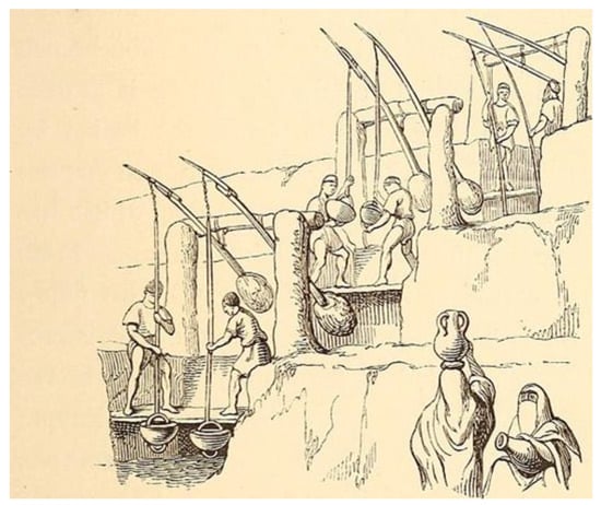
Figure 4.
Multi-Stage Shaduf System used in Egypt since 700 AD [].
Urban areas featured rudimentary sewerage systems, which included drainage channels designed to handle wastewater and stormwater, maintained public hygiene, and reduced the risk of disease. Some cities had public baths and private bathrooms connected to these drainage systems, demonstrating an early understanding of sanitation. These systems were essential for maintaining the health and cleanliness of densely populated areas [].
Ancient Egyptians gave great attention to sanitation issues to safeguard the health and environment. They seemingly had sustainable sanitation systems. These systems had many levels depending on the social classes of people. For instance, in Herakopolis city (ca 2100 BC), the waste was not collected and instead was thrown directly on the streets. In the places settled by higher classes, such as leaders and priests, the streets were clean, and waste was disposed of far away from the residential areas to protect public health [].
Ancient Egyptians built toilets near their houses. In the time of the New Kingdom, elite people built small toilets inside houses. In large homes, a toilet and bathroom were built beside the bedrooms. These toilets consisted of an opening on the ground covered by stone slabs (Figure 5). Houses of common people usually did not have internal bathrooms. Starting from 2500 BC, ancient Egyptians used drainage systems and purification methods, even in kings’ burials: based on their belief, death was a conversion from one life status to another. As daily requirements of food and other resources were needed for life, they also were needed after death. Archaeologists have discovered bathrooms in tombs such as the temples of Kings Suhura and Osiris [].
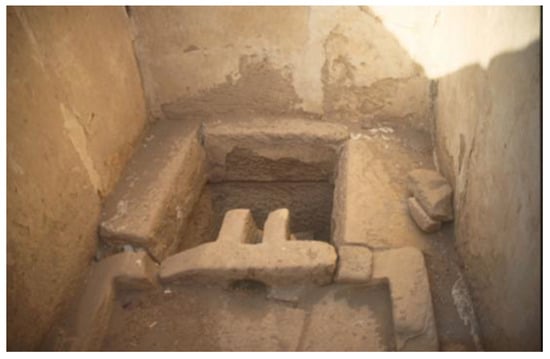
Figure 5.
Bathroom in the palace of Ramesses III at Medinet Habu in Luxor, Egypt (1221–1156 BC), Picture: H. Köpp-Junk [].
Water supply systems were set up for villages far away from the Nile by transport by manpower or animals. Water supply points were established in desert areas by preparing cisterns and wells on the roads [].
Supply and drainage systems were set up by Romans in Egypt, especially to convey Nile water to Alexandria. Stone-made siphons to transfer water long distances at high hydraulic heads were developed by Hellenic engineers like Archimedes [].
In Cairo, the Sultans of the Ayyubid and then those of the Mamluk states constructed a long, masonry arched aqueduct to transport Nile water to the castle in the 13th century. This extended from the Nile shore, and water wheels were used to raise water into the aqueduct and then move it by gravity to the Fortress. The remains of the aqueduct can still be seen today [,].
2.5. India: Vedic Period (ca 1500–500 BC)
The Vedic period in the Indian subcontinent, spanning from approximately 1500 to 500 BC, witnessed significant cultural and technological advances. During this period, the four Vedas, ancient sacred texts of Hinduism, primarily concerned with spiritual, philosophical, and ritual aspects of society, were composed; nevertheless, they do contain some references to urban settlements, architecture, and water management []. The Rigveda, the oldest of the four Vedas, mentions “grama” and “pura“, settlements and cities, respectively, indicating the existence of organized settlements with dedicated spaces for different purposes.
The Vedic period, usually divided into early Vedic (ca 1500–1100 BC) and late Vedic (ca 1100–500 BC), witnessed remarkable advances in agriculture, metallurgy, manufacturing of goods, and social changes that laid the foundation for the emergence of the Mahājanapadas and Mauryan Empire [,,,]. Vastu Shastra, the ancient Indian science of architecture and urban planning, which was concerned with the design and layout of buildings, took into account factors such as alignment, proportion, and cosmic harmony [].
Vedic texts contain valuable references to the water cycle and highlight the ancient Indians’ understanding of natural phenomena []. Concepts such as evaporation, condensation, precipitation, flow, and the transformation of water were recognized []. The same texts recognize the influence of various meteorological factors on precipitation patterns, including cyclonic effects and the warming of the earth caused by radiation [].
Hydrological phenomena such as infiltration, interception, runoff, and erosion were discussed in texts such as the Rigveda, the Atharvaveda, and in Mauryan period literature, the Arthashastra []. The Atharvaveda and the Yajurveda also address the movement of water from the clouds to the earth and emphasize the importance of rivers, wells, and canals for water distribution and management [,].
The Ramayana, dated to around 200 BC, mentions artesian wells, emphasizing the importance of groundwater development in ancient times []. In addition, texts such as the Brihat Samhita and the Mahabharata offer insights into the problems of water quality and nature-based solutions for obtaining drinking water []. These ancient texts provide insight into the scientific knowledge of the time and emphasize the practical wisdom and environmental awareness of ancient Indian societies.
2.6. Hittite Empire in Minor Asia (Anatolia) (ca 1750–860 BC)
The settlement of Anatolia during the Chalcolithic (5600–3750 BC) and the Bronze Age (ca 3200–1100 BC) defines the transition from village to city. The concept of the city here involves not only the densification of settlements but also the emergence of a new form of governance and bureaucratic and artisan classes []. In addition to the development of urbanization concepts, water and food, the economy, power struggles, and institutionalization have become important factors [,]. As a result, urban morphology evolved from protective tents and cave dwellings to a built urban environment surrounded by walls and castles. The Hittites were the first to establish a state in Anatolia []. Hattuşaş (Boğazköy) served as the capital of their kingdom in the 2nd millennium BC since the area proved very suitable for settlement due to surrounding vegetation, multiple water sources, and fertile soil for agriculture [].
Boğazköy, which is on the UNESCO World Heritage List [], was built on a rocky terrain sloping in a south–north direction. The Hittites considered stones and rocks to be sacred. Rocky ground and foundations are combined in the architecture: most buildings were built with large stones using an overlapping technique. Water was of crucial importance in the Hittite period. The concept of water testing and water cults includes rituals and norms that prove the value of water from the legal and religious perspective of the Hittite civilization []. These rituals and norms regulated social life and facilitated the fulfillment of daily needs through the creation of water structures such as dams, reservoirs, canals, and water monuments [,]. There is not much information about the hydraulic structures from the early period of the Hittite kingdom. However, it is seen that the kings of the latter empire period built dams (Karakuyu Dam, Köylütolu Dam, and Gölpınar Reservoir) [] in addition to cultic hydraulic structures. The Karakuyu Dam is 8 m high and has a total crest length of 400 m. The Köylütolu Dam is one of the oldest and largest dams in Anatolia at this time; the Gölpınar Dam is the oldest still in operation [].
Cisterns carved into the rock in the form of barrels facilitated the collection and distribution of rainwater within cities. Ponds, which were often built near temples, also served the purpose of collecting water and performing religious ceremonies. Water rooms connected to temples and houses for water supply, as well as water tanks for the disposal of wastewater and the collection of clean water, were notable structures. As in ancient times, baked clay pipes for clean water were also used [].
2.7. Urartu Period in Minor Asia (Anatolia) (ca 860–675 BC)
During the Urartian period, agricultural irrigation was dominant in the use and distribution of water in Anatolia []. Urartian rulers constructed a series of dams, ponds, and irrigation canals in the eastern Anatolian region, which facilitated agriculture development in the plains and valleys, leading to a golden age period.
Urartians also lived in the Van region. They were among the first to use the Kehriz system (a forerunner of piped irrigation), which transports water from a source or aquifer to the surface through underground channels. This system prevents evaporative water loss in dry regions and ensures that water is not contaminated from the outside. There are 54 kehriz in Van, some of which may date back to the Urartian period [].
A large number of irrigation systems were built in the Eastern Anatolia Region. The famous Menua (Semiramis/Shamram) Canal, 56 km long, dating back to 800 BC, was constructed to meet the needs of agriculture and irrigation and is one of the oldest canals still in use. With some modifications, the canal currently still irrigates about 2000 ha of land. Another water-bearing canal is the Ferhat Canal in the province of Ağrı. In some places, the canal was carved through hard rock, with sections 2.00–2.50 m wide and 1.00–1.50 m deep. The slopes are reinforced with walls up to 11 m high. In this respect, it is similar to the Shamram Canal [,].
Some existing cisterns in this region have Urartian origins; examples are those in Van Castle and the cistern in Toprakkale, which are carved into the rock within the castle to store water required by the city []. It is assumed that the five dams in the Van region, of which the Faruk Dam is the best known, also date from the Urartian period [].
2.8. Carthaginian Empire (ca 814–146 BC)
The Carthaginian Empire, with its foundation traditionally dated to around 814 BC, developed a highly sophisticated approach to urban planning, especially evident during the period of the Punic Wars (264–146 BC). At that time, urban planning and water management systems were remarkably advanced, reflecting a high degree of sophistication and engineering prowess. Carthage, the capital city located in present-day Tunisia, was a major urban center renowned for its strategic layout, which included distinct residential, commercial, and military zones. This well-organized urban design was pivotal in accommodating the city’s diverse functions and growing population.
One of the most notable architectural features of Carthage was its impressive fortifications, designed to protect the city from invasion. These not only underscored the city’s military strength but also its advanced engineering capabilities. A defining architectural marvel of Carthage was its double harbor, consisting of separate commercial and military harbors. The commercial harbor was designed to accommodate many merchant ships, facilitating Carthage’s extensive trade across the Mediterranean. Adjacent to it was the military harbor, which housed the city’s formidable navy and featured a circular design with docks radiating outward, allowing for efficient organization and rapid deployment of ships. Carthage also boasted advanced residential areas with multi-story houses, well-planned public spaces, markets, and bathhouses that catered to the social and economic needs of its citizens [,].
The Carthaginians were adept at managing their water supply, a critical aspect for maintaining a thriving urban center in the arid region of North Africa. One of their key achievements was the construction of aqueducts, which transported water from distant sources into the city []. These aqueducts were marvels of engineering, featuring precisely angled channels that utilized gravity to move water over long distances, ensuring a steady and reliable supply. In addition to aqueducts, Carthage employed large cisterns and reservoirs to store water (Figure 6a). These facilities were essential for maintaining a water supply during dry periods and ensuring that the city could withstand sieges or other disruptive events. The cisterns were often massive underground chambers (Figure 6b), carefully constructed to maximize storage capacity and minimize evaporation.
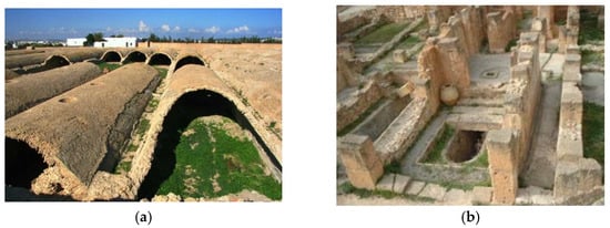
Figure 6.
Ancient cisterns at Carthage, Tunisia: (a) remains of cistern (https://www.britannica.com/event/Battle-of-the-Trebbia-River#/media/1/97373/198919, accessed on 2 July 2024); (b) cistern (ca 2nd BC) under building in the Byrsa Hill (https://hydriaproject.info/en/case-studies/water-supply-in-roman-carthage/waterworks, accessed on 2 July 2024).
Carthage also had advanced drainage systems to manage wastewater and maintain urban hygiene. These systems included underground sewers and surface drains that efficiently removed waste and rainwater from the city, preventing flooding and reducing the risk of disease. The combination of aqueducts, cisterns, and drainage systems highlights Carthage’s advanced understanding of water management and its ability to sustain a large urban population in a challenging environment.
2.9. Archaic, Classical, and Hellenistic Periods (ca 750–31 BC)
In late Archaic Greece, Hippodamus Miletus (ca 498–408 BC), architect, urban planner, physicist, mathematician, meteorologist, and philosopher, also considered the “father of urban planning”, introduced the Hippodamian system to urban planning. The Hippodamian building plan is essentially a city plan that looks like a gridiron. This was an important innovation that significantly influenced urban water transportation systems later in the Hellenistic period and into the modern era []. Already in the early classical period, ancient Greeks had developed and implemented Hippodamian-orthogonal water supply and drainage systems to protect cities from flooding. The most well-known ancient city, drawn and planned by Hippodamus Miletus, is the ancient city of Piraeus. Similarly to the ancient city of Piraeus, Miletus was an ancient Greek city on the western coast of Anatolia planned during the Classical Period, with a relatively simple and chessboard-like subdivision into rectangular sections with straight streets []. The water of Miletus was drawn from springs on Kalabak Hill in the southwest and from the hills between Akköy and Yeniköy further south; wells were also used []. Long-distance water pipelines in the Turkish Aegean coastline and Mediterranean regions are numerous, and their variety is constantly expanding with new discoveries.
Many classical cities such as Pella, Olynthos, Kassope, and Alexandria the Great were closely based on Hippodamus’ designs []. Alexandria the Great in Egypt was one of the largest cities of antiquity, founded in 331 BC by Alexander the Great, and one of the most important centers of culture in its heyday, famous for its library, museum, and lighthouse, one of the Seven Wonders of the World. Urban planning, roads, and, of course, the water supply, drainage, and sewage networks were based on the ideal plans of the Hippodamus of Miletus (ca 498–408) and on protection against flooding (Figure 7) [].
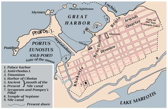
Figure 7.
Map of ancient Alexandria (ca 30 BC).
The long history of advanced water management and distribution in ancient Greece is partly due to the scarcity of water caused by both the dry climate and the greater-than-average distance of Greek settlements from larger bodies of freshwater []. “There are only a limited number of practical options for water supply in arid areas. Basic elements of water supply and management include techniques for diverting, retaining, and storing ephemeral water flows such as local rain. Cisterns, for example, which are essentially watertight, usually underground storage tanks, have been a common water supply tool in many areas of the world as they are a very effective and practical solution for water storage”.
A water cistern from the Hellenistic period in ancient Plevrona (western Greece) is located on a hill on the northwest side of Messolonghi. It is an impressively great cistern, possibly covered originally (Figure 8a), which measures 21.5 × 12.3 m and 7.2 m deep, with a capacity of 2500 m3. Another example of a rainwater harvesting and storage cistern from this period is the outdoor public rainwater cistern in the Hellenistic town of Orraon (Ammotopos) (Figure 8b) in northwestern Greece [].
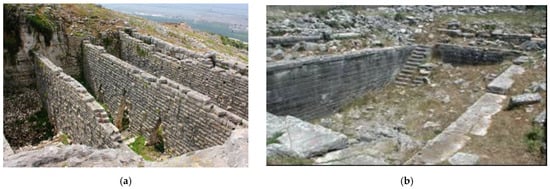
Figure 8.
Hellenistic time water cisterns used for water supply: (a) in ancient Plevrona, western Greece (Photo A. N. Angelakis); (b) open-air public cistern at Orrao, northern Greece (Photo G. Antoniou) [].
In Classical and Hellenistic times, an admirable balance was achieved between structural and nonstructural (institutional) measures, large-scale (e.g., the Peisistratean aqueduct) and small-scale (wells and cisterns) projects, and the interests of the public for large-scale works and private interests for small-scale works sectors []. In Athens, for example, there were two main streams, Ilisos and Kephisos.
Hippocrates (ca 460–370 BC), the father of medicine, carried out several experiments in water purification, as the quality was often far from the desired level of purity he wanted. He designed a fabric membrane (the Hippocratic water filter) through which the water, which was boiled before consumption, was passed. In fact, around 400 BC, he invented and used the first water filtration system in the form of a cloth bag, now known as Hippocrates’ sleeve (Figure 9a), a forerunner of modern filtration systems (Figure 9b). This material was used to remove impurities from drinking water after it had been boiled. Specifically, the method consisted of a piece of cloth folded at the corners into which water could be poured, usually after it had been boiled, and then allowed to run through to increase cleanliness for use in medical procedures []. The idea of seawater desalination was developed in the Lyceum (itinerant school) of Aristotle (355–328 BC) in Athens. This technology goes back to ancient Greek sailors, who used it in the 4th century BC with the evaporation of seawater, which Aristotle first described after corresponding experiments, during which he also discovered the principle of conservation of mass in the water cycle and much more [].
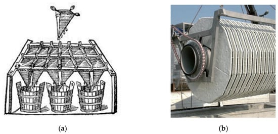
Figure 9.
(a) Hippocratic water filter []. (b) Modern pile cloth rotating filter (MITA Water Technologies, Siziano, Italy).
2.10. Minor Asia (Anatolia) (ca 675–133 BC)
Cities in Ionian Minor Asia consisted of acropolises, built on higher ground, and residential areas, including an agora, on low terrain. For cities in the Aegean region, geomorphological suitability for defense, the presence of water sources, the fertility of the soil, and the location of main roads were important for the urbanization of a village. The best-known example of this is the city of Priene, one of the ancient Greek cities of Ionia, founded on the southern terrace of Mount Mycale in the Büyük Menderes region [,]. The city of Priene, which was founded according to geomorphological and water management aspects, received its water from the mountain via an aqueduct. It used the sloping terrain to allow the water to flow into the city center by gravity. The water was collected and purified in basins and then distributed throughout the city via clay pipes. There were also three cisterns at the entrance of the city to meet its water needs [] and many fountains throughout the city to distribute and utilize the water [,].
In this period, urban planning was classified as either regular or irregular: the irregular urban structure emerged as a result of the natural coalescence of villages, generally in the Aegean region and its surroundings; regular urban planning, on the other hand, developed in the Ionian cities with the concept of polis, i.e., the city. This planning followed a grid system with parallel and orthogonal streets (Hippodamian design). Examples of cities built according to the grid system are Ephesus (the most important Greek city in Ionian Minor Asia), Kolophon, Lebedos, Teos, Phokaia (Foça), Klazomenai, Priene and Smyrna (Izmir) [,,,]. In Aegean and Mediterranean coastal areas, cities were often planned as trading centers and called ports []. Common people’s houses were architecturally simple; they stood close together in narrow and winding streets; they consisted of different rooms arranged around an enclosed courtyard with small, high windows. The width of the streets was about four to six meters, probably covered with gravel and stones laid out to allow rainwater to drain underground, especially in towns built on steep slopes []. Cities were surrounded by walls made of stone and mud bricks, planned with strategic considerations (defense), and took advantage of the natural features of the terrain without compressing the city, i.e., without affecting the urban plan.
Between 500 and 400 BC, during the Persian invasion, many cities were completely destroyed. After that, from 323 to 30 BC, the Hellenistic period took place in Minor Asia (Anatolia) [,]. Among the most important features of this period were the development of urbanization, the construction of numerous water channels, and an increase in the variety and number of water supply systems. Among the ancient water transportation systems in Turkey, the 240 km long aqueduct from the south of the Istranca Mountains to Istanbul is the most important in terms of total length. It was the longest in the ancient world, compared to the 100 km waterway from Muradiye to Foça, the 65 km one from Soma to Pergamon, and the 43 km from Kuşadası to Ephesus [,]. These systems included aqueduct bridges up to 40 m high, water tunnels with a diameter of more than 2 m, inverted lead pipe siphons operated with water heads of up to 190 m, and stone pipes operated with water pressure of 155 m []. These siphons operated under the highest pressures in the ancient world, dating back to the late centuries of the 1st millennium BC []. The stone inverted siphon of Aspendos is the longest on arches in Turkey, with a length of about 1.7 km [,,]. Water conduits also included terracotta, stone, and lead pipes of various diameters, channels carved into rock or built of masonry, spring collection systems, urban reservoirs, and water distribution and sewage networks. The twin tunnel-shaped structures spanning the Bergama River, dated to the early 2nd century AD (Roman period), are still in place, and the largest of their kind with height of 7.5 m, width of 9 m and capacity of 720 m3/s [,].
In cities rebuilt or newly founded during the Hellenistic period, porticoes were enlarged in streets intersecting at right angles, winged stoats were built, agoras laid out, multi-story houses built, and municipal council buildings erected. As the cities became more densely populated, neighborhoods expanded outwards []. Wells and water channels were built to utilize groundwater, surface water, and rainwater to meet the increasing water demand. One example is the ancient city of Larissa, north of Izmir, on the right bank of the Hermos River: its water needs were satisfied by wells known as “Yirmi kuyular” (Twenty Wells) [].
Pergamon (Bergama), planned at the confluence of two rivers during the Hellenistic period, used an urban layout that followed orography. The city’s water was distributed via a high-pressure system to canals and, from there, to reservoirs within the city. The water supply systems to Pergamon, Smyrna (Izmir), and Ephesus make these cities, along with Rome, Lyon, and several others, the most interesting examples of multiple urban water supply systems in the ancient world [], with extension spanning 65 km in Pergamon, 30 km in Smyrna, and 42 km in Ephesus []. In the Smyrna water system, quarry stone canals had arched or stone slab covers; ventilation shafts were placed at irregular intervals along canals, which had an average height of 2.16 m and width of 0.90 m. The high-pressure Pergamon water supply was developed in the 2nd century BC with two lead pipe conduits with an inner diameter of 17.5 cm and length of 3250 m, and pressure-resistant clay pipes with thick walls (7 cm) and diameter of 18 cm, secured with 50 cm high stone anchors []. Pergamon had steep terrain, which made rainwater runoff a problem; therefore, the city planning included sewers for rainwater control [].
2.11. Mauryan Empire (ca 321–185 BC)
The Mauryan dynasty, under the leadership of Emperor Chandragupta Maurya, ruler of the first pan-Indian empire around 320 BC, witnessed significant advances in governance, including water management, attributed to Kautilya, the chief minister of Chandragupta as documented in the Arthashastra []. One notable aspect mentioned in the Arthashastra is the “Variyantra”, a manually operated air-cooling device similar to a water cooler used by the wealthy sections of society []. In addition, the Arthashastra contains detailed accounts of hydraulic systems used for irrigation and other purposes. During the Mauryan Empire (about 322 to 185 BC), characterized as a remarkable hydraulic civilization, hydraulic structures such as the Pynes and Ahars (combined irrigation and water management systems) and the Sudarshan Lake reservoir at Girnar were built []. Megasthenes (ca 350–290 BC), the ancient Greek historian, mentioned that more than half of the arable land was irrigated, resulting in two harvests per year []. There was a separate governmental department responsible for the supervision, construction, and maintenance of the well-developed irrigation system, including canals, sluices, wells, lakes, and tanks. The same office was also in charge of the planning and allocation of uncultivated land.
The importance of hydraulic systems during the Mauryan period is reflected in the severity of punishments imposed on offenders, as described in the Arthashastra []. Water pricing was also an essential component of the water management system, with different tariffs applied depending on the irrigation method. The Mauryan Empire showed remarkable progress in meteorological observation, including the establishment of the first observatory to measure rainfall with a rain gauge called the Varshamaan []. Reservoirs, dams, and canals with spillways were built for irrigation and domestic purposes, with careful consideration of the water balance. The Mauryan period is considered the first great hydraulic civilization, marked by the development of rainfall forecasting systems and the introduction of sophisticated water management techniques []. These advances underscore the empire’s commitment to harnessing water resources for agricultural and social prosperity.
2.12. Roman Period (ca 31 BC-480 AD)
The Romans used the Hippodamian plan when they established military camps, expanded existing cities (e.g., Pompeii), or founded new ones (e.g., Augusta Emerita). They called residential blocks insulate “islands”. For example, Ticinum (now Pavia in Northern Italy) evolved from a military garrison on a river crossing shows persisting evidence of its Roman sewer system dated to 89 BC and is still partly in use (Figure 10).
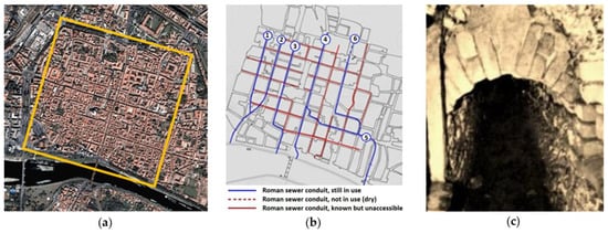
Figure 10.
Roman findings: (a) Aerial image of the city of Pavia (formerly Ticinum, a Roman military camp on the Ticino River) in Italy. The city center (highlighted by the yellow line), with many medieval-age buildings, still clearly shows the original Roman layout, with the two main arteries (the N/S one leading to the bridge crossing the river) intersecting in the middle. Secondary streets still outline the “insulate” pattern. (b) Roman sewers, still partly in use, run along the north–south street grid toward the river. (c) A section of Roman conduit (conduit 2 in (b)), approx. 0.5 m wide × 1.1 m high, still in operation.
As for the water supply during the Roman and first Byzantine periods (ca 31 BC–821 AD), no new water technologies were developed, but the Classical and Hellenistic technologies were expanded to satisfy the increasing needs of the population. Romans developed several aqueducts in various cities. A good example is the Aqua Appia, which was the first Roman aqueduct, and its construction began in 312 BC by the censor Appius Claudius Caecus, who also built the important Via Appia. By the end of the 1st century BC, it had fallen out of use as an aqueduct and was used as a sewer instead. The aqueduct was named after Appius alone because Plautius resigned after serving 18 months as a censor, while Appius deceitfully kept his position until the aqueduct was completed []. In Cretan settlements from Roman times, such as Aptera in western Crete, there were large cisterns with a capacity of up to several hundred m3 [] (Figure 11a). Several ancient cities relied solely on rainwater storage to become self-sufficient and ensure survival in the event of a siege. In Crete, evidence from the later Venetian period (about 1500 AD) indicates the existence of more than 500 cisterns in the city of Iraklion alone []. This was not the case with Carthage in North Africa, which was equipped with an aqueduct a century after its destruction by the Romans in 146 BC.
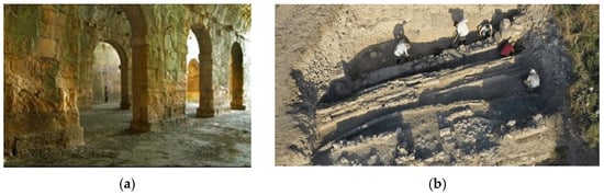
Figure 11.
(a) Interior view of the three-aisled vaulted Roman cistern in the ancient town Aptera, Crete, estimated volume of 2900 m3 (with permission of A. N. Angelakis). (b) Discovered water pipes in Antioch (https://www.enikos.gr/timeout/anakalyfthikan-12-solines-pou-trofodotousan-me-nero-mia-archaia-elliniki-poli-ti-apokalyptoun-gia-tin-periochi/2246064/, accessed on 23 November 2024).
In the rescue excavations following earthquakes in 2023, twelve pipes from the Late Roman Period were unearthed in the ruins of an ancient Greek city, Antioch, in the Hatay province (southern Turkey). This initially puzzled archaeologists, who subsequently discovered that they led to ancient drinking water sources (Figure 11b).
2.12.1. Roman and Byzantine Period in Minor Asia (Anatolia) (ca 133 BC to 395 AD)
A fundamental difference between city plans and city walls before and during the Roman period can be seen in Minor Asia (Anatolia). In Roman urban planning, residential areas were pushed to the outskirts of the city, while city centers were used as representative spaces rather than for settlement purposes, with an emphasis on urban and architectural hierarchy. Roman cities generally had a Hippodamian geometric layout, consisting of regular, rectangular blocks, with two main streets in north–south and east–west directions, intersecting at a central square. The Roman Empire built gymnasiums, stadiums, theaters, city and agora buildings, baths, libraries, houses, aqueducts, and large squares in every city of Anatolia, which were considered important symbols of the city []. Compared to the pre-Roman period, Roman streets were wider, with sewers and water channels constructed both underground and along the streets []. Recent studies reveal the complexity and extent of the late Roman water supply system. The largest such system was the 494 km long aqueduct that brought clean drinking water from the Belgrade Forest (Belgrad Ormanı) to Constantinople (Istanbul), supplying six of the nine public baths, a large cistern, two public fountains, and ninety-eight of the city’s 156 smaller baths [,]. Numerous water bridges, cisterns, fountains, and baths were built along its route; enclosed channels were built from mortar-bonded stone blocks with vaulted roofs 1 m wide by 1.6 m high. Within the city, the Bozdoğan Aqueduct (also known as Valens Aqueduct), a bridge with 87 arches and a length of 971 m, is considered one of the longest aqueducts in the Roman world [].
Water was an important factor in Roman urban planning. In the ancient city of Perge, for example, the city expanded into a lower town during the Hellenistic period. In the context of urban planning, the colonnaded street of the north–south axis of the lower city is a still well-preserved and remarkable example of the sort, with a water channel running longitudinally through the center of the north–south colonnaded street [,,]. In the Roman period, numerous waterways were built to meet the water needs of Smyrna (ancient İzmir), whose history spans thousands of years: these include the ancient Karapınar waterway, crossing the Melez River with a stone pipe inverted siphon, as well as the Akpınar and Buca waterways [,].
One of the most important dams built in the Roman period is the Çevlik Dam. The history of the tunnel and the river diversion system in Çevlik dates back to Roman times []. It was designed to prevent the port of Seleucia Pieria near Antakya from being obstructed by sediment. The capacity of the 875 m long system is 70 m3/h, including two tunnels extending 90 and 30 m in length, respectively. Its cross-sections are U-shaped or trapezoidal, between 6 and 7 m in width, the largest of the time [].
In the Hellenistic and Roman periods, hollowed-out stone blocks were made into pipes used in pressurized siphons. These stone blocks generally ranged in length from 0.6 to 1.20 m []. An example of this can be seen in İzmir, where a valley is crossed by a stone siphon with an internal pipe diameter of 16 cm carrying water from the Karapınar spring (altitude 750 m); another technique was the combined use of clay and stone pipes, as in Antalya-Seki []. One of the most magnificent hydraulic structures in Anatolia is located in Aspendos, where a stone-pipe reverse siphon and aqueduct system was used: two towers built 924 m apart, connected by a siphon of interlocking stone pipe (30 cm in diameter) fed the city’s water supply [].
Numerous fountains were built in Anatolia in Roman times: the Nymphaion Fountain is one of the largest; another can be found in Pisidia Antiocheia, located 1 km from the town of Yalvaç (Isparta): a monumental U-shaped fountain at the northern end of the town’s north–south axis, 21 × 21 m in size, with a column facade in the front and a reservoir in the back. Water from Antiocheia aqueducts was collected in a reservoir and, from there, distributed throughout the city via lead and clay pipes [].
Cisterns built in the early days of the Roman Empire were small structures carved into the rock, most of which supplied water to palace buildings. The increased dependence on water resources due to the expansion of the country and population growth increased the importance and size of the cisterns, highlighting their architectural features as either indoor or outdoor above-ground basins []. Many Roman period cisterns have been discovered, some of which have survived to this day: recently, in 2010, during excavations in Smyrna (İzmir Kadifekale), a Roman cistern covering an area of 1000 m2 was unearthed [].
Cisterns serving as water reservoirs for large cities have been of great importance throughout Anatolian history. During the Byzantine Period, cisterns were built underground as vaulted structures supported by columns. Initially, these stood independently, but they began to be connected to the city’s water network from the 5th century AD onwards. In this context, the cisterns built in Constantinople (Istanbul) between the 4th and 8th centuries, between 150 and 250 m long, are among the most fascinating examples of the period []. The largest of these is the “Basilica Cistern”, which was built on a rocky terrain in Sultanahmet and is known as the “Yerebatan Cistern” (Figure 12). This covers an area of around 10,000 m2, measuring 140 × 70 m, with a water storage capacity of around 100,000 m3. The structure consists of 336 columns, each 9 m high, supporting a brick vault, arranged in 12 rows, each consisting of 28 columns spaced 4.80 m apart. Most of the columns, carved from different types of marble, are either in one piece or composed of two parts. One of the secrets of the Basilica Cistern lies in its water tightness, which played a decisive role in its construction: the interior rock surfaces were coated with materials such as Roman cement, plaster, lime, or clay to resist permeation [,,].
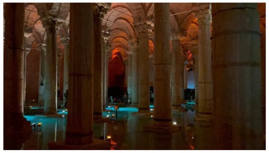
Figure 12.
Basilica Cistern in Istanbul.
It has now been ascertained that the entire underground water system was not interconnected, and only a certain volume of water could be distributed through independent water facilities commissioned by emperors, rulers, and bureaucrats []. Open-air cisterns of immense size, resembling ponds, with rectangular or square plans, surrounded by thick walls, had the purpose of collecting rainwater or floodwater, from which water could be discharged into urban sewers if required. These open cisterns were too large to be covered; as an example, the Aetios cistern measured 244 × 85 m2 []. Their walls were approximately 4–6 m thick with heights ranging from 10–15 m, made alternatively of brick and stone using Roman construction techniques, with bricks and pieces of marble beaten within and mixed with lime and linseed oil to prevent leakage, thin areas plastered and covered; walls were reinforced with buttresses to withstand the pressure of water [,].
2.12.2. Roman North Africa (ca 146 BC–7th Century AD)
The legacy of Roman urbanism in North Africa still endures across the Mediterranean through architectural landmarks, archaeological remains, and impact on urban landscapes. Innovations in urban planning and water management underscore the resilience and ingenuity of Roman civilization in adapting to diverse environmental and geographical challenges []. Roman North Africa, spanning present-day Algeria, Libya, Morocco, and Tunisia, witnessed significant urban development following the defeat of Carthage in 146 BC. This period saw the proliferation of Roman cities, characterized by the adoption of the Roman grid plan, which reflected the empire’s standardized approach to urban design and administration. Key periods include the post-Carthaginian era (146 BC), Roman Imperial rule (27 BC–476 AD), and the Byzantine Period (533–646 AD).
Cities such as Timgad, Carthage, and Leptis Magna featured orthogonal streets intersecting, which divided the urban space into insulates and boasted impressive civic amenities such as forums, theatres, public baths, and villas. Public baths, an integral part of Roman urban life, offered facilities for bathing, exercise, and socialization, reflecting the importance of hygiene and communal activities in Roman society [].
Roman architectural styles left a profound imprint on North African cities, which are evident in monumental structures such as amphitheaters, like the one in El Djem, and triumphal arches, such as the Arch of Trajan in Timgad city (ancient Thamugadi) near Batna, Algeria, aqueducts, and basilicas. The latter, with their grand architectural features and spacious interiors, served as centers of commerce, justice, and administration, reinforcing their importance as urban landmarks.
Romans implemented sophisticated systems to ensure reliable water supply for their cities: aqueducts played a crucial role in delivering water from distant sources. The Zaghouan Aqueduct (Figure 13), one of the most notable examples, transported water through arches and conduits from its source in Zaghouan for a total of 132 km to supply Carthage (Figure 14a), ensuring an adequate supply for its growing population and urban amenities, including the Baths of Antonius, a facility on the same scale as the Imperial baths in Rome, that demanded steady supply of water [].
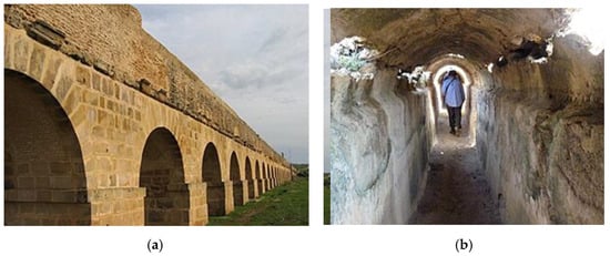
Figure 13.
Zaghouan Aqueduct Tunis (Carthage): (a) exterior (https://fr.m.wikipedia.org/wiki/Fichier:Zaghouan_aqueduc.jpg, accessed on 3 July 2024); (b) interior (https://commons.wikimedia.org/wiki/File:Aqueduct_of_Zaghouan_interior.jpg, accessed on 3 July 2024).
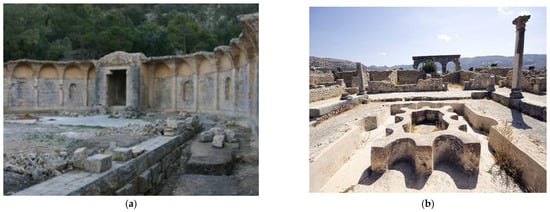
Figure 14.
Water supply be aqueducts: (a) building of the sacred Zaghouan spring, which fed one of the longest aqueducts built by Romans, carrying water 132 km to Carthage (https://carthagemagazine.com/zaghouan-aqueduct-water-supply-in-roman-carthage/, accessed on 3 July 2024); (b) interior of the North Baths, fed by the aqueduct at Volubilis, Berber–Roman city, Morocco (source: https://en.wikipedia.org/wiki/Volubilis#/media/File:Volubilis_North_Baths.jpg, accessed on 3 July 2024).
Public baths (thermae) and fountains (nymphaea) were ubiquitous in Roman cities, serving as focal points for socializing and relaxation while also demonstrating advanced water distribution systems (Figure 14b). The public baths provided facilities for bathing, exercise, and social interaction, reflecting the Roman emphasis on hygiene and communal well-being. Fountains, adorned with decorative elements and sculptural features, supplied potable water to residents and served as aesthetic embellishments within urban spaces, enhancing the quality of public life [].
Sophisticated sewage and drainage systems were integral to maintaining public health and sanitation in Roman cities. Sewage systems, consisting of underground conduits and channels, transported wastewater away from urban areas to prevent contamination and foul odors. Drainage systems, including surface channels and culverts, facilitated the removal of rainwater and surface runoff, reducing the risk of flooding and waterborne diseases [].
2.13. Sasanian Empire (ca 224 AD–651 AD)
The historical association of gardens with ceremonial centers dates to the Achaemenid Empire and particularly to the construction of the palatial garden complex at Pasargadae, the first capital of Cyrus the Great, in 550 BC. The irrigation system at Pasargadae consisted of cross-axial water channels dividing the entire area into four quarters, each accommodating a monumental palace. Given the fact that the Sasanians considered themselves to be the rightful heirs of the Achaemenids, it is no surprise that Ardašīr attempted to find a royal capital reminiscent of Cyrus the Great’s model of palatial gardens at Pasargadae. The present-day pattern of agricultural plots along the remains of the concentric rings and radial axes could support the assumption that palatial gardens and villas were spread both inside the city and across the plain beyond [].
The irrigation methods of the Fîrûzâbâd plain included forty-six aqueducts and six waterways that irrigated the plain in the era of Ardašīrand, contributing to its prosperity up to the tenth century. Many Arab medieval sources describe the magnificent water transfer scheme to the inner circle of Ardašīr-Xwarrahand and a magic fountain on top of the Tirbal, a mysterious feature that astonished medieval geographers. While present-day archaeological findings do not prove such a magic transfer of water to the top of Tirbal, one cannot dismiss the sacred and symbolic role of water and its celebration by Sasanians and their ancestors []. It is important to note that Ardašīr’s father, Papag, was a hereditary guardian of the temple dedicated to Anāhitā, the Zoroastrian goddess of water, at the city of Istakhr during the Arsacid’s reign. The practice of worshiping Anāhitā dates to the Achaemenids. It was realized in the construction of a site of worship dedicated to her glory at Kangavar, a cult that passed through the Arsacids and Sasanians and which continued even after the Muslim conquest of Persia [].
In a brilliant piece of archaeological research, Noruzzadeh et al. [] investigated the water supply system of Ardašīr-Xwarrah. This study clarifies some of the ambiguities concerning the city’s water supply encountered by geographers in the last century. The lower altitude of the inner circular zone of the city versus the Great Palace of Ardašīr and the ancient routes of water transfer reveal that the major water supply of the city and the gardens surrounding was provided by the front pond of the Great Palace of Ardašīr. A precise system of aqueducts, canals, and a bridge carried the water from the pond in the western part of the river to the inner circular zone of Ardašīr-Xwarrah [].
The remains of a watermill belonging to the Islamic era on the southeast fringe of the inner fortification wall and the archaeological discovery of a stone and Sarooj-a traditional water-resistant mortar-water channel on the traces of the inner wall sheds light on the possible circulation of water in the inner zone of the city. It is likely that the water, after circulation around the inner zone of the city, reached the entire city in such a way that all the radial axes and concentric rings of Ardašīr-Xwarrah could have supplied water to the gardens, palaces, and villas. Therefore, the radial-concentric could be seen as an efficient tool for distributing water to palatial gardens and surrounding areas, thereby contributing to a regional territorial plan [].
2.14. Seljuks Turks in Minor Asia (Anatolia) (1000–1299 AD)
After the Roman and Byzantine periods, Anatolia was ruled by the Seljuks Turks. During this period, Turkish-Islamic culture and civilization prevailed in urban planning. In this urban planning, bridges were built to ensure water supply. The canal that runs through the asymmetrical side openings of the Haburman Bridge and feeds a mill is the most interesting hydraulic facility of this period [,]. On the other hand, not many aqueducts have been found from the Anatolian Seljuk period. The water supply systems built during this period were based on agricultural needs. Some of the known irrigation canals from the Seljuk period are the “Sahip Ata” irrigation canals in Konya, the Meram irrigation canals in Konya, the Aksaray irrigation arches, and the waterways of Kubadabad palace [,].
2.15. Great Zimbabwe (ca 1100–1500 AD)
Urban Planning
Great Zimbabwe was a medieval city in the southeastern hills of Zimbabwe, near Lake Mutirikwe and the city of Masvingo. It was the capital of the Kingdom of Zimbabwe during the country’s Late Iron Age []. The city’s urban layout is characterized by impressive stone enclosures and towers that serve as symbols of political and social authority. It was divided into distinct architectural complexes, each with its unique functions. The Hill Complex, built on a natural rock outcrop, probably served as the administrative and religious center of the city.
The urban layout of Great Zimbabwe reflects a high degree of centralization and organization, with clear delineations between different sectors of society. The stone structures, built using a technique known as dry-stone masonry, demonstrate the city’s architectural sophistication and engineering prowess. The intricate design and careful construction of these buildings suggest a well-planned urban environment that met the needs of its inhabitants while projecting power and prestige [].
Water management was vital to the sustainability of Great Zimbabwe, especially given its location in a semi-arid region. The inhabitants used several strategies to collect and distribute water within the city. Wells and channels were constructed to collect and channel water from natural sources such as nearby rivers or seasonal streams. Proximity to water sources played a crucial role in the city’s water management strategies, providing residents with access to fresh water for drinking, cooking, and irrigation. Wells provided a reliable source of groundwater, while channels facilitated the distribution of water to different parts of the urban area, ensuring that all residents had access to this vital resource. The inhabitants of Great Zimbabwe likely practiced a combination of rainwater harvesting and surface water management techniques to supplement their water supply. The city’s location near rivers and streams provided opportunities for the construction of dams and reservoirs that could collect and store rainwater during the rainy season for use during drier periods [,].
According to a recent discovery, depressions known as Dhaka pits have long been used by the inhabitants of Great Zimbabwe for water storage and harvesting, possibly since the emergence of settlement in the mid-second millennium AD. These pits were part of a landscape-scale water management system that exploited catchment hydrology and groundwater through artificial Dhaka reservoirs, wells, and springs to provide water for subsistence, agriculture, and ritual and ceremonial services. These water storage facilities would have been essential for maintaining agricultural productivity and supporting the city’s growing population.
3. Early and Mid-Modern Times (ca 1350–1750 AD)
3.1. Incas in South America (1438–1572 AD)
The Incas were a pre-Columbian civilization that flourished in South America and were also the largest empire on the continent, which fell with the conquest of the New World by the Spanish who conquered them violently and were led by the Spanish conquistador Francisco Pizarro []. Their capital was Cuzco in present-day Peru. Incans built a series of aqueducts in order to increase water supply and baths to the Inca people. An example is the aqueducts can be found at the archeological site at Tipón. Located thirteen miles east of Cuzco in the Cuzco Valley, this ensemble of ruins was once an estate for the Inca elite and nobility (Figure 15). The aqueducts of this area are set atop walls that predate the Inca occupation of the area. Scholars believe these walls, too, have been built by the Wari civilization. After the Inca took control of Tipón in 1400 AD, Emperor Vircocha sent engineers to survey the site. Those engineers reinforced the existing Wari wall by using andesite and the characteristic Inca technique of mortarless masonry [,].
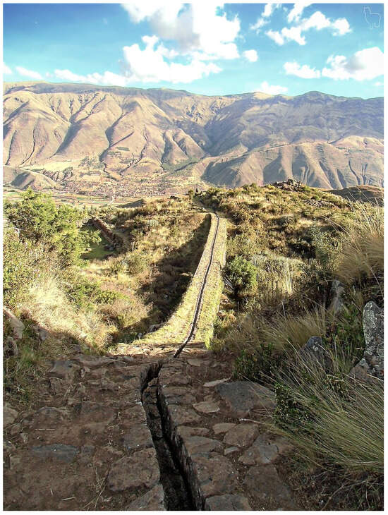
Figure 15.
Inca aqueduct at Tipón in Cusco, Peru (https://en.wikipedia.org/wiki/Inca_aqueducts, accessed on 23 November 2024).
3.2. Renaissance in Baroque Europe (ca 1350–1750)
There is little record of other water supply and sanitation systems (apart from those in ancient Rome) in most of Europe until the High Middle Ages. Unhygienic conditions and overcrowding were widespread throughout Europe and Asia during the Middle Ages. Very high infant and child mortality prevailed in Europe throughout medieval times due partly to deficiencies in water supply and, in general, in sanitation.
In Europe during Medieval times, water technology and knowledge made little progress. During this period, the emphasis was on wars rather than on civilization. Water supply and general hygiene, in the best cases, reverted to the basics, becoming very primitive in most towns. As a result, disease outbreaks were commonplace; epidemics decimated towns and villages. In Europe, during Medieval times, at least 25% of the population died due to cholera, plague, and other waterborne diseases []. This resulted in pandemics such as the Plague of Justinian (541–542) and the Black Death (1347–1351), which killed tens of millions of people []. Gradually, as populations expanded, the disposal of human feces became an issue in large cities during the Middle Ages. Waste disposal was, for the most part, unregulated. For instance, in Paris, it was only in 1530 that a municipal decree required property owners to construct cesspools in each new dwelling []. Generally, each neighborhood and community had a self-interested attitude toward water supply and municipal wastewater services.
3.3. Renaissance in India (ca 1350–1750)
Water supply systems in medieval India comprised a diverse array of structures and techniques crafted to capture, store, and distribute water effectively. Among the most prominent water supply systems in medieval India were stepwells, characterized by their elaborate design and functionality. Stepwells featured a series of steps leading down to a well, enabling access to groundwater even during dry seasons. Notably, these structures were not merely utilitarian but also served as architectural masterpieces adorned with intricate carvings and sculptures (Figure 16).
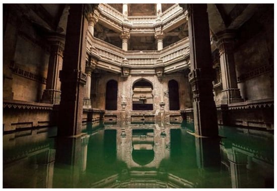
Figure 16.
Adalaj Vav stepwell in Gujarat, dating back to the XIV century.
Another prevalent feature of water supply systems, particularly in South India, was the construction of tanks. These tanks served as expansive reservoirs for storing rainwater and runoff from nearby hills, playing a crucial role in replenishing groundwater, supporting agricultural activities, and ensuring a dependable water source for communities during drought periods [].
Medieval India boasted a multitude of reservoirs and lakes meticulously constructed to capture and retain water from rivers and monsoon rains. Ranging from small village ponds to colossal lakes commissioned by monarchs and local leaders, these reservoirs demanded substantial investment and engineering acumen to sustain agriculture and urban settlements []. A striking testament to medieval Indian civil engineering ingenuity is Madag Lake, commissioned by the monarchs of Vijayanagara. Perched atop the Tungabhadra River, this expansive lake spanned 10 to 15 km when at full capacity, featuring three earth dams equipped with sluices crafted from massive slabs of hewn stone [,].
The region of Rajasthan boasted numerous significant water storage reservoirs, including the Dhebar Lake in Mewar and the Udaisagar, along with other notable lakes such as Rajsamand and Jaisamand in Mewar and Balsan and Mansagar in the Marwar and Amber areas. The Mughal period in India, spanning from 1526 to 1857, marked a significant era in water management and infrastructure development. Under the Mughal rule, sophisticated hydraulic systems, canals, and reservoirs were constructed to tackle the challenges posed by water scarcity and distribution across the empire []. This period witnessed remarkable advancements in water management techniques, reflecting the Mughals’ commitment to harnessing water resources for agricultural productivity, urban development, and societal well-being. Throughout the Mughal Empire, minor lakes for rainwater storage were commonplace across villages. Recognizing the importance of irrigation, the Mughal administration offered advances to farmers in regions like Khandesh and Berar to construct irrigation dams []. Mughal engineers introduced sophisticated irrigation systems, including Persian wheels, which consisted of a large wheel with buckets attached to its rim and were often powered by oxen, to lift water from a source and deliver it to irrigation canals, which significantly improved water management and crop yields. Canals were dug to channel water from reservoirs and rivers to farmland, ensuring consistent irrigation throughout the year. These engineering feats required meticulous planning and construction, often involving the labor of thousands of workers. Even today, Khandesh boasts a substantial network of these minor dams, covering the basins of major rivers in the area.
In the northern plains, canal irrigation played a significant role, with historical figures like Sultan Feroz Tughlaq and Shah Jahan overseeing the construction of extensive canal networks []. Notable examples include the Nahr-iFaiz, a 150 km canal commissioned by Shah Jahan, and the canal near Lahore, carved out of the Ravi River. However, Mughal canals often faced limitations as they rarely rose above the surrounding plain, restricting the amount of water available for irrigation []. In contrast, South India relied primarily on other water management techniques, such as tanks and reservoirs, due to the lack of documented canals.
The qanat system, originating from Persia, played a pivotal role in harnessing groundwater. This system involved the development of groundwater extraction technology through man-made underground water conduits known as Kanehat (Kariz or Qanat) []. Kundi Bhandara, a remarkable underground water management system developed in the seventeenth century in Burhanpur, Madhya Pradesh, stands as a testament to the Mughals’ ingenuity in water systems []. This unique structure, built on the concept of the Qanat system from Persia, showcases unparalleled constructional techniques and remains a glorious relic of Mughal engineering.
Water supply systems in medieval India emphasized community participation in construction, maintenance, and management. Local communities were responsible for the upkeep of wells, tanks, and reservoirs, ensuring equitable access to water resources for all members of society []. Larger-scale infrastructure projects were often undertaken by the state or temple administrations, with monarchs, rulers, and religious institutions funding the construction of major reservoirs, dams, and canals to support agriculture, trade, and urban development.
3.4. Ottoman Period (1300–1923 AD)
In the 16th and 17th centuries, the Ottoman Empire had reached its widest extension. During the Ottoman period, considerable efforts were made in water distribution to further expand the systems established by the Roman and Byzantine civilizations and to meet the water needs of the people more effectively. Constantinople’ (present-day Istanbul), Halkalı waterways, which supplied the European side of Istanbul, consisted of a total of 16 different aqueducts with a total length of 130 km []. The Süleymaniye waterway, with a total length of 50 km, consisted mainly of fired clay pipe conduits, with some tunnel sections and water arches. The Edirne–Taşlı Müsellim waterways had a total length of 50 km []. The pipeline was a masonry structure, passing across several aqueducts and tunnel sections. The Constantinople–Kırkçeşme waterways, which were built during the Ottoman period, collected surface water from the Belgrade Forest and transported it to the city for a 55 km pipeline with monumental water arches. It was the largest water system built during the Ottoman period, put into operation around 450 years ago, which solved the city’s water problem for a long time. The most important water arches of the Kırkçeşme Waterway are the Mağlova aqueducts (two stories, sixteen arches), the Kovuk aqueducts (three stories, forty-seven arches), the Güzelce aqueducts (two stories, nineteen arches), the Paşa aqueducts (two stories, thirteen arches) and the Uzun aqueducts (two stories, ninety-seven arches) [,,]. Pipelines were mostly made of fired clay pipes, and features included water equalization towers for pressure control and distribution []. Water brought to the garden of Kanuni Sultan Süleyman was collected in wells and water towers; a single-story square-shaped water tower was located in Gebze.
The Constantinople–Üsküdar waterway was also built in the 16–19th century. Its total length is 23 km, with a masonry tunnel pipeline, including a 400 m-long aqueduct and an inverted siphon at the beginning. The Hamidiye waterway was also integrated into this system []. The most important dams of the Ottoman period were Topuz, Büyük, Ayvat, and Kirazlı in the Kırkçeşme system, in addition to the Topuzlu, Valide, and Yeni dams in the Taksim system [,]. Other hydraulic structures from the Ottoman period include the İzmir Waterways, Gediz Riverbed Alteration (directed to the outer bay to prevent silting of the Izmir Bay), Malatya-Sürgü Irrigation, Beyşehir Water Supply Link, Çumra Irrigation, Tarsus Hydroelectric Power Plant and many wells [,,]. The scheme utilized the elevation difference of the Berdan River at Tarsus Falls [].
During the Ottoman period, numerous structures were built to improve public access to water: wells, fountains, public baths, and drinking taps. In the 19th century, the construction of railroad lines to İzmir and the increased activity in the port of İzmir led to continued city growth. As water supply problems that began in the 18th century persisted, a solution was sought through public water concessions, and the management of water affairs was entrusted to the “İzmir Suları Osmanlı Şirketi” (İzmir Water Ottoman Company, İzmir, Türkiye). The Company first tapped the Halkapınar springs, with a supply potential of 1200 L/s. Water pipes were laid within the city to collect water from the springs, and the Halkapınar Water Factory, consisting of a main reservoir and a steam-powered central pumping station, partly still in operation today, was built. Subsequently, a new water reservoir with a capacity of 600 m3 was built at an altitude of 157 m to supply water to the higher districts of the city. In addition, during the construction of the port of İzmir in the Ottoman period, the Rıhtım Company laid around 2000 m of sewer pipes in the port area. The city was equipped with a sewerage network consisting of 33 sewers built by the municipality in addition to the 19 existing sewers, but this system was damaged in the great fire of 1922 [].
The system of pipes, sheds, and arches brought water from the forests to the north of the city. Stored water was distributed from a stone reservoir from which the square and its surroundings take their name []. Spirit levels, which first appeared in ancient Rome, were most commonly used during the Ottoman period to prevent pipes from being exposed to different pressures, and they have remained standing structures until today [].
Cisterns built at that time were square, with walls made of an irregularly arranged stone-brick mixture and covered with earth mortar. The interior, with an approximate ceiling height of 3 m, was completely plastered with concrete []. Wells were dug nearby. The most famous well in Istanbul is the Dolap Ocağı Well, under the Topkapı palace. Numerous water distribution points called “Maksems”, hydraulic structures with domes or vaults were equipped with a mechanism that directs water brought from outside the city by pipes to a distribution basin (boat or chest), with the flow measured through short pipes called “lüle” [].
4. Contemporary Times (1750–Present)
4.1. Enlightenment, Europe and America (ca 1750–1800)
The earliest examples of planned communities showed ancient cultures building cities according to grid plans, often organizing streets with major thoroughfares running north to south and east to west. In medieval times, city planning often became chaotic and piecemeal (Figure 17a) the more efficient Hippodamian orthogonal grid plan was subsequently re-adopetd in the developed world (e.g., Europe and USA) (Figure 17b) during the Enlightenment.
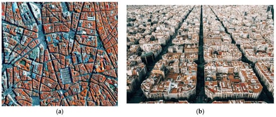
Figure 17.
(a) The layout of a Madrid neighborhood dating from medieval times. (b) Grid-type plans developed in newly urbanized city areas.
During early contemporary times, life expectancy was shortened due to several infectious diseases, such as pneumonia, tuberculosis, meningitis, etc., causing many premature deaths. Kramek and Loh [] reported an example of this situation in Philadelphia, USA, where several hundred typhoid deaths occurred at the end of the 19th century due to water pollution. In 1896, the Global Water Initiative of the Philadelphia Water Department was initiated to address the typhoid problems: Installation of filtration treatment to increase the capacity of sedimentation reservoirs was proposed. It was calculated that an adequate filtration system for Philadelphia would require 160 ha of land and USD 8 million to construct, a monumental sum at that time. In comparison, a modest investment of USD 200,000 was believed to be sufficient to repair leaking reservoirs, increasing retention time for sedimentation. Unfortunately, this could not solve the typhoid problem [].
Following the completion of a filtration facility in 1912 and the chlorination of the city water supply in 1913, typhoid deaths were dramatically reduced. This fact demonstrates that there is a direct connection between sanitation measures and human health and that technological progress in water treatment is extremely beneficial for humankind (Figure 18). Since that time, life expectancy has greatly increased; e.g., in Greece during the last 100 years, it was doubled mainly due to the improvement of water quality.
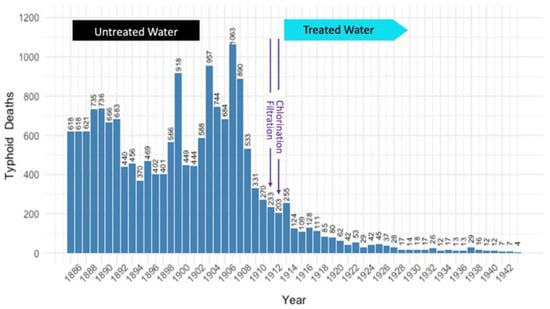
Figure 18.
The number of typhoid deaths in Philadelphia was drastically reduced following the city-wide water filtration (1912) and chlorination (1914) system. Data from the Philadelphia Water Department Collection (Adapted from []).
4.2. British India (ca 1750–1900 AD)
With the arrival of colonialism and the ensuing modernization drives, traditional water supply and management methods in India began to collapse []. The policies of British colonialism, which were intended to promote economic exploitation and consolidate power, had a substantial effect on indigenous water management techniques []. The British government gave centralized water infrastructure projects top priority, frequently at the expense of traditional systems that were essential to the ecosystems and livelihoods of the surrounding populations [].
Large-scale irrigation projects and dam construction were encouraged by British colonial policy to further interests in industry, agriculture, and urban growth []. The disdain for community-based management systems and local knowledge in these initiatives frequently resulted in the marginalization of indigenous customs []. In addition, the implementation of land ownership regulations and revenue-based taxation further upended conventional water management systems, eroding local communities’ sovereignty and reducing their control over water resources [].
To promote agricultural productivity and economic development, the British colonial administration built and constructed canal irrigation projects []. Large land areas were altered by canals like the Upper Ganga Canal, which made irrigation possible and encouraged the expansion of agriculture. Throughout imperial India, reservoirs and dams were built to control water flow, lessen flooding, and store water for drinking and irrigation. Major dam projects started during the colonial era include the Mettur Dam in Tamil Nadu, with a reservoir area of 42.5 km2 and capacity of 2.64 km3, and the Bhakra Dam in the Punjab province of British India, with a 9.34 km3 capacity over an area of 168.35 km2.
Water resources regulation and equitable distribution were the goals of the institutional and legislative reforms brought in by the British. Water rights, usage, and disputes were governed by enacted laws and regulations. To supervise the development of infrastructure and water management, institutional structures were put in place. Even if the goals of these programs were to enhance water supply systems in specific regions, it is critical to acknowledge that they frequently gave colonial objectives precedence over the needs and viewpoints of local communities. India’s current water problems are shaped by the legacy of colonial water management policies, underscoring the significance of fair and sustainable approaches to water governance and management.
The colonial era’s rapid industrialization and urbanization contributed to the traditional water collection systems’ downfall []. Growing urban and industrial areas’ increasing water demands prompted the exploitation of natural water sources, which frequently led to over-extraction, pollution, and ecological deterioration []. The robustness of traditional water management systems was further undermined when traditional water infrastructure, such as tanks, ponds, and stepwells, were neglected or repurposed to suit the demands of urban expansion and industrialization [].
Although traditional Indian water delivery systems were greatly impacted by British colonial policies, it is also important to remember that these regulations also marked the beginning of efforts to upgrade water supply infrastructure. Water delivery systems were developed in metropolitan areas and military outposts as a result of the need for dependable water sources for administrative, commercial, and military purposes. The British contributed to the advancement of water supply systems in several ways; they made investments to raise urban areas’ standards of hygiene and water quality due to concerns about public health and sanitation []. To supply clean water to city dwellers, the British started building waterworks, reservoirs, and distribution networks in important colonial towns like Calcutta, Bombay, and Madras []. One notable urban water supply project carried out during the colonial era is the Tolly Nullah waterworks in Calcutta, which was constructed in the early 19th century. Waterborne diseases such as dysentery and cholera were addressed with the establishment of sanitation boards and the implementation of specific measures. To improve water quality and safeguard public health, sewage systems and filtration facilities were built [].
5. Knowledge Transfer and Technological Exchange in Water Management
Ancient civilizations engaged in significant knowledge transfer and technological exchange in water management (Appendix A—Table A1). The Romans adopted and enhanced Egyptian hydraulic engineering, notably in Alexandria’s aqueducts and sewage networks. Minoan water supply methods bore similarities to Mesopotamian practices, suggesting early exchanges. The Indus Valley civilization pioneered cylindrical brick-lined wells, which later appeared in Mesopotamia. During the Ptolemaic period, Greek urban planning influenced Egyptian water infrastructure, shaping later Roman designs. Additionally, the Persian qanat system was adapted by the Mughals in India for efficient water distribution. These examples demonstrate how civilizations refined and shared water management techniques, fostering advancements in sustainability and urban planning.
Of high importance is the link of historical water supply practices with potential solutions for current water management issues. In line with this is the case of an integrated public water supply system that optimized water flow for both rural and urban purposes and was built in Assyria (ca 703–690 BC). The aqueduct comprised a blend of open channels and subterranean tunnels designed for water transportation. It featured an intricate system of channels carved into the rock and reinforced with stone to mitigate erosion and prevent leakage. The aqueduct was engineered to optimize water flow, incorporating elements such as sluice gates and settling basins to regulate and purify the water. Additionally, the Assyrians exhibited a profound comprehension of hydraulic principles, designing the aqueduct to enhance water flow while minimizing losses. Their capability to regulate water pressure and flow rates was remarkably advanced for their era. The aqueduct’s sturdy construction has enabled it to withstand the test of time, with many of its original characteristics still observable today [].
6. Emerging Trends and Possible Future Challenges
6.1. Growing Population and Urbanization
The global population has grown from one billion in 1800 to over 8.1 billion in 2024, but water use has grown exponentially in comparison: estimates of aggregate global water use indicate a 15-fold increase between 1800 and 1980, compared to a just 4-fold population increase in the same period []. The UN projected population estimates have put the total population at 8.60 billion by mid-2030, 9.80 billion by mid-2050, and 11.20 billion by 2100. Cities account for a growing share of national economies and concentrate opportunities and wealth: migration into cities from rural areas is led by young people looking for opportunities to meet their aspirations. Today, more than half of the world’s population is living in urban areas, particularly in highly dense cities; by 2050, more than two-thirds of the population will live in urban areas (Figure 19). As the world continues to urbanize rapidly, the share of the global population living in cities is projected to reach 64% by 2040, up from 57% in 2023. This growth highlights the need for innovative and sustainable solutions to boost urban liveability, resilience, and efficiency [].
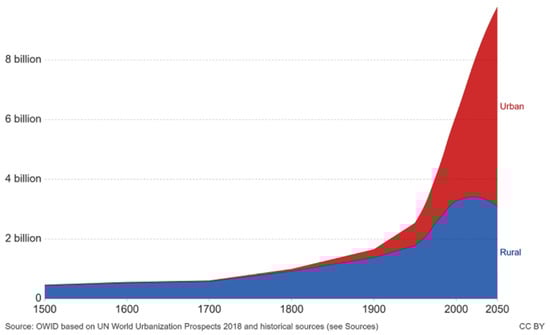
Figure 19.
Urban and rural population projected to 2050 [].
As a consequence, there will be more and larger cities in the future; this could contribute to an additional billion (0.829–1.135) people facing urban water scarcity, which is an additional 87.5% of the total []. Globally, 526 cities have >1 million inhabitants today, of which 193 are located in water-scarce regions; the same is true for nine existing megacities (>10 million): six (Bangalore, Beijing, Delhi, Lahore, Los Angeles, Moscow) are subject to perennial scarcity and three (Istanbul, Karachi, Mexico City) to seasonal scarcity. An analysis of 12 megacities’ (194 million people, total) water balance showed that demand outranges supply in 11 of them []. Climate change trends are also projected to alter water availability and increase the urban population subject to water scarcity by about 5% of the total increase [].
In the absence of significant changes in resources management, urban population growth sets the ground for possible “Day Zero” events (i.e., conditions whereby water use is restricted to vital services only) as experienced in São Paulo (Brazil) in 2013–2015 and nearly averted in Cape Town (South Africa) in 2016–2018. Recent reports indicate that Day Zero may be approaching for Mexico City, where groundwater, a source of 60% of the supply, shows levels declining by more than 0.5 m/yr, and urban distribution losses exceed 40% [].
Significant impacts of urbanization and pollution are expected on the availability and quality of water resources and potential water demand []. According to the United Nations, 2.2 billion people lacked access to safely managed drinking water as of 2022, while 3.5 billion lacked safely managed sanitation services. The situation is projected to worsen significantly by 2050 if current trends persist. A recent study evaluated potential changes in water scarcity and quality risks for 304 large cities around the world till 2050, using different socioeconomic and climate change scenarios highlighting high risk for 90% of them, mostly due to quality rather than scarcity issues [].
Given that available fresh water supplies on earth will remain essentially the same, being unevenly distributed, expanding urban areas will become even more water-stressed, enhancing the conflicts among users, particularly among urban, agricultural, and industrial users []. These factors should be carefully considered in the long-term planning for water resources sustainability, evaluating alternative water supplies, as well as adopting strategies and measures promising improved water use efficiency [,].
Urban development and sprawl can significantly impact water supply systems. Hosseini et al. [] analyzed the effect of urban sprawl on a traditional water system (qanat) in the City of Mashhad, located in the northeast of Iran. Data analysis reveals that rapid urbanization, as well as uncontrolled urban expansion, has led to the intersection of city infrastructure and qanats, especially during the last few decades. This phenomenon has destroyed 88 qanat fields, led to water shortage in the city of Mash-had, and to the substitution of sustainable and environment-friendly systems with alternative locally unsustainable water systems such as dams and wells.
Water management is typically treated as an “end-of-the-pipeline” issue, leading to overloaded drainage systems and environmental and flooding problems. Urban water systems design is typically incremental, i.e., it occurs along with the development of new urban areas, with locations and layouts determined by a number of drivers, such as topography, nearby population densities, and access to transportation networks. Their technical lifetime is in the order of 30–100 years, and key drivers include vast uncertainties related to actual population growth and the locations of urban development projections, technological evolution, and the expected availability of water resources due to climatic variability effects []. Resilience, which indicates the ability of a system to overcome foreseen or sudden changes, maintain its functions at least partially, and return to its initial state afterward, is an essential property of public infrastructure; in fact, water crises in recent years highlight insufficient resilience of many systems to the combined effects of hydrologic cycle change, increased urbanization, and governance challenges.
Adaptability and flexibility, essential qualities of resilient systems, can be achieved both through physical design and infrastructure management. Distributed infrastructure can avoid adverse event-related functionality failures by considering internal and external connectivity, e.g., overlapping alternative service routes to increase systems’ ability to share spare capacities among their components []. Discussions on the type of approach (centralized, decentralized, hybrid) more likely to contribute to increased water system resilience seem to converge on decentralization [,,,].
Water use reduction on a structural basis and initiatives aimed at resource conservation and reuse should be undertaken in order to achieve sustainability of water supply [,]. Approaches to reduce water demand include water-use efficiency measures (e.g., new crops and irrigation techniques for improving agricultural water productivity, water-recycling facilities for domestic and industrial water-use intensity improvement), water use reduction by adoption of more efficient consumption models (e.g., low flow fixtures, mandatory use reductions, higher water tariffs), and limitation of local population growth. Reuse and adoption of alternative technologies, such as vacuum sewers, can significantly curtail water use (vacuum sewers require <0.5 L/flush, compared to 4–5 L/flush of modern low flush toilets) without significant drawbacks [].
To find the best ways to address urban water scarcity, we assessed the feasibility of these potential solutions for each large city. As was mentioned before, Hippodamian philosophy regarding the study, planning, and construction of new cities was developed in Greece during the Classical period and was improved further in the Hellenistic period. The theories developed were more advanced, were closer to the modern meaning of scientific concepts and assumptions, and were equipped with a better understanding of physics. The latter theoretical progress allowed significant technological progress, which, however, was soon interrupted and continued with further significant developments only during or after the Renaissance (ca 1500 AD). Today, it is adopted worldwide and followed even by underdeveloped countries. In Greece, however, adaptation has been minimal, particularly in the expansion of large urban centers such as Athens, Thessaloniki, Piraeus, Patra, Larissa, and Heraklion.
6.2. Energy Consumption Issues and Greenhouse Gas (GHGs) Emissions
Energy consumption and greenhouse gas emissions (GHG) emissions in urban water supply and wastewater treatment systems are crucial constraints to urban water management [,,] and are subject to spatial heterogeneity of local factors. The latter study highlighted, among others, the connection between the urban water supply systems and the economy, environment, and climate sectors; in another study, a comprehensive management model for urban water resources system was developed, including the water-energy-carbon nexus as well as multiple uncertainties, applied to the water and energy sources shortage in Qingdao city (China) with the objectives of maximizing water extraction, production, and sewage treatment system benefits along with minimizing carbon emission []. Limitation of water demand was identified as a critical factor of energy consumption and carbon emission in urban water systems, requiring a synergy of actions such as changes in energy supply (i.e., from sludge utilization), energy consumption control, water resources allocation schemes, and water supply structure. Studies have shown that energy consumption of wastewater treatment could be reduced by up to 80% by implementing systematic programs to monitor and manage its use and by optimizing process operation [].
Global urban water infrastructure in developed countries is aging and often in need of upgrading: water distribution losses in some areas can be as high as 50%; reportedly, 20% of supply water in England is lost by leakage, compared to approximately 3% in Germany and 5% in Singapore. This not only affects supply but also its related energy demand and carbon emissions; it was estimated that, in California, each 10% loss reduction could avoid approximately 39,000 t/y of CO2 emissions []. The cost of distribution losses has been evaluated globally at 39 billion USD/y [], about a third of the estimated annual investments needed for the overall achievement of the UN’s SDG 6.
6.3. Addressing Challenges in Urban Water Planning
Due to urbanization and user density within, the water sector is highly centralized: globally, the 50 largest water utilities supply, alone, drinking water and sanitation to more than 1 billion people. The current water management and sanitation paradigm has seen little substantial progress since its early adoption: its current underlying engineering paradigm is based on a technical consensus dating to the late XIX century, which persistence to this day has hindered the development of possible, more efficient alternatives to present issues and challenges. There is, therefore, ample margin for improvement, should the sector choose to act upon it.
Urban water scarcity in modern times has typically been addressed via engineering and grey infrastructure. Primary domains, such as urban growth, policy frameworks, integrated urban water resource management and planning approaches, stakeholder engagement practices, the introduction of motivation measures, cross-sectoral coordination, green urban water infrastructure initiatives, high water efficiency technologies and practices, water reuse practices, innovative (low-cost) monitoring technologies, decision-support tools, pollution mitigation measures, and climate change resilience strategies should be of concern and priority to address water challenges [,].
The feasibility of each potential solution depends on the characteristics and environmental setting of each water-scarce city: for example, coastal cities can adopt desalination or coastal reservoir construction; settlements located on naturally recharged aquifers can increase exploitation of groundwater, combined with artificial recharge; areas subject to seasonal water scarcity and in the presence of suitable topography can implement reservoir construction.
Interbasin water transfer could be a last-resort solution, as can be seen, for example, in southern California, where over 80% of Los Angeles freshwater comes from water transfers from the San Joaquin and Colorado Rivers, or China, where IBWT projects affect 3/4 of the country’s population. In the latter case, more than half of the affected population benefited from alleviated scarcity, although 20% were subject to increased scarcity in source watersheds []. Wastewater reuse has been practiced since early civilizations for agricultural production, and this tendency is again being considered in water-scarce areas [,]. Current technology allows us to treat waste and marginal quality water to any level for a specified use []. Where no potential solution is likely to solve scarcity issues (e.g., due to location or economic development levels), urban planning should be directed at limiting the influx of new population or promoting alternative development models [].
Inspired by ancient water management practices, modern urban water management can benefit from the integration of nature-based solutions and traditional knowledge with modern technology. Ancient civilizations, such as those of the Indus Valley and the Roman Empire, used advanced systems to harvest, store, and distribute water. These systems emphasize sustainability and efficiency. By adopting techniques such as rainwater harvesting, the construction of resilient infrastructure that mimics natural water cycles, and the use of gravity-fed distribution systems, we can create more sustainable and resilient urban water systems.
An approach recently adopted in China, aiming at increasing resilience through adaptive planning, is the “Sponge City” concept []. This represents an evolution of ancient water management models, which replaces extensive “gray infrastructure” (pipes, dams, canals) in order to reproduce the natural hydrological cycle within an urban area, representing a transformative change from present-day engineering-oriented paradigms. The benefits of sponge cities include source reduction, process control, regulation, and disaster response, simultaneously reducing flood risk and achieving drought mitigation by extended storage and its delayed release. Green infrastructure requires less input than conventional gray infrastructure: construction requires fewer resources, operation less energy, and large green areas become net CO2 sinks, improving urban environments. Mitigating floods is critical for many vulnerable areas of the planet. Practices supporting sustainability were adopted by most of the ancient civilizations and could prove to be beneficial even in the present day in modernized versions [].
By combining time-tested methods with modern innovations, such as the Internet of Things (IoT) and Artificial Intelligence (AI), water security, pollution reduction, and more equitable access to clean water could be achieved [,]. The next foreseeable frontier of AI application in the water sector is given by Digital Twins (DTs). DTs represent objects (i.e., aqueducts and even entire cities) and processes (water treatment processes) in a virtual replica, which were designed for automatic fault diagnosis, run-time monitoring, and process control. AI introduction in water resources operations could be a significant innovation compared to current mainstream operational practice. In general, however, this technology is still largely perceived at the potential level [].
6.4. Urban Planning and Sustainable Development Goals (SDGs)
Sustainable Development Goal 6 (SDG 6) (Clean Water and Sanitation) aims to ensure the availability and sustainable management of water supply and hygienic conditions for all by 2030. This goal encompasses a broad spectrum of targets, such as those mentioned above, designed to address the global water crisis, focusing on improving water supply and quality, increasing water-use efficiency, and ensuring equitable access to drinking water and hygienic services. A recent study using network analysis has revealed that the interconnections and complementarities across SDGs 6–13 as infrastructure, energy, water, socio-economic sectors, and climate, are involved [,]. There are, however, differences in goals development among different cities and regions. The frameworks for evaluating sustainable development have been established, which include indicators that enable the assessment of progress toward the SDGs across space and time [], and models that interlink specific SDGs, stakeholders, and ecosystem services with water reuse schemes have been proposed [].
Conventional urban planning and related water systems are increasingly regarded as too rigid and not sufficiently resilient to confront the growing SDGs’ challenges in association with all the related environmental and social pressures. New paradigms promote the concept of infrastructure with a wider meaning, merging technical and environmental elements with social and environmental context and benefits from available ecosystem services []. In these paradigms, circular flows of resources generate multiple products and services, with low, upfront capital requirements for ubiquitous networks embedded in the urban fabric, which are intentionally visible and represent a vital part of the public life, in contrast with the old paradigm’s infrastructure, which are composed of independent elements and are invisible to the public (like buried pipes or treatment facilities in remote locations), and detached from the urban context [].
Urbanization has exacerbated the impacts and perception of climate variability, with urban centers being systematically warmer than their surrounding areas due to the urban heat island effect [,]. However, local mitigation through “sponge cities” concepts, green roofs and walls (Figure 20), and other innovative local planning strategies can reduce this effect while decreasing energy costs, improving air and water quality, sequestering carbon, and providing habitat for urban wildlife [].
Figure 20.
Green surfaces: (a) Green roof in Singapore []; (b) Green wall at One Central Park, Sydney Central Business District (Source: Greenroofs.com LLC, https://www.greenroofs.com/, accessed on 15 January 2025).
A systematic literature review study suggested that 74 (44%) of the SDGs’ 169 specific targets, including most SDG6′s, could be achieved through the implementation of natural solutions in urban areas and the use of ecosystem services that the environment provides freely. The analysis showed the need for a system change in urban areas worldwide, where green infrastructure can contribute to 80% of the targets in SDG11, “Sustainable Cities and Society” [].
Integrating historical water management principles with modern public policies and emerging technologies offers promising solutions for enhancing urban water resilience. Ancient civilizations, such as the Indus Valley and the Roman Empire, implemented sustainable water harvesting, storage, and distribution techniques that remain relevant today. For example, traditional gravity-fed systems like qanats and aqueducts can inspire energy-efficient urban water infrastructure, reducing reliance on high-energy pumping systems. In modern policymaking, aligning these historical approaches with Sustainable Development Goals (SDGs), particularly SDG 6 (Clean Water and Sanitation), can help cities develop strategies for equitable water access while addressing climate change challenges. Additionally, the integration of smart technologies such as the Internet of Things (IoT), AI-based real-time monitoring, and Digital Twins for water infrastructure can optimize resource management and early fault detection, reducing water losses and improving system efficiency. Furthermore, nature-based solutions inspired by historical flood control measures, such as Mesopotamian drainage canals, can help mitigate urban flooding risks in an era of increased climate variability. By harmonizing these historical techniques with cutting-edge innovations, urban planners and policymakers can create robust, sustainable, and adaptive water management systems that address modern urbanization challenges.
To adapt ancient water management practices to meet modern urban challenges, integrating nature-based solutions with advanced technology offers a viable approach. Traditional rainwater harvesting, employed by civilizations like the Indus Valley and Minoans, can enhance water security in urban areas, especially where centralized infrastructure is insufficient. Gravity-fed water distribution systems, such as Roman aqueducts and Persian qanats, can reduce energy consumption in water transportation, making urban water systems more sustainable. Additionally, ancient flood mitigation techniques, such as Mesopotamian drainage canals, can inform modern stormwater management strategies to prevent urban flooding. By integrating these time-tested methods with contemporary innovations like LoT-based real-time water monitoring and AI-driven resource optimization, urban water management can become more efficient, resilient, and environmentally sustainable.
Several traditional water management practices have direct applications for addressing modern urban water challenges. Rainwater harvesting, extensively used by the Indus Valley and Minoan civilizations, remains a viable solution for enhancing water security in water-scarce urban areas. Gravity-fed distribution systems, such as the Roman aqueducts and Persian qanats, provide energy-efficient alternatives to modern water supply infrastructure, reducing reliance on energy-intensive pumping. The use of green infrastructure, inspired by ancient drainage and irrigation systems, can help mitigate urban flooding and improve stormwater management. By adapting and refining these time-tested techniques, cities can create sustainable water management solutions that address contemporary challenges while reducing environmental impact.
Historical water management practices offer valuable insights for addressing contemporary urban water challenges. Many ancient civilizations, such as the Indus Valley, Mesopotamians, and Romans, implemented advanced water harvesting, storage, and distribution techniques that emphasized sustainability and resilience. For instance, gravity-fed water transport systems, like Roman aqueducts and Persian qanats, minimized energy consumption, a concept that modern cities could integrate to enhance efficiency. Additionally, traditional flood management strategies, such as Mesopotamian drainage canals and stepwells in India, demonstrate how passive infrastructure can be leveraged for urban climate resilience. The Nile’s controlled irrigation systems in Ancient Egypt and the Mauryan Empire’s extensive reservoir networks provide lessons on balancing water supply with sustainable agricultural practices. By incorporating these historical principles into modern technologies, such as smart water monitoring systems, nature-based solutions, and AI-driven resource management, urban planners can develop adaptive and low-impact water infrastructure to meet growing demands while mitigating climate change effects.
6.5. Historical Practices for Addressing Current Urban Water Challenges
To put in perspective the ancient water management principles and practices discussed in this paper, it is important to examine their relevance to modern times and to extract some lessons learned []. The relevance of ancient works will be examined in terms of the evolution of technology, technological advances, design principles, and management principles as follows:
- (a)
- The evolution of science and engineering is not linear but rather characterized by discontinuities and regressions. On the other hand, it is not “Markovian” in the sense that only the present (i.e., the state at a certain time instant) and not the past (i.e., the entire history) influences the future. “Bridges” from the past to the future are always present, albeit sometimes invisible in the present. Thus, in addition to many constructions that have been continuously or intermittently in operation up to the present day, written information from ancient Greece has survived [].
- (b)
- Water progress. To some extent, there are differences in the apparatus and the scale of applications and not differences in the fundamental principles used. Even the lifestyle related to the hygienic standards of the civilization may not be a recent development. For example, flushing toilets equipped with seats, which resembled present-day toilets and were drained by sewers, existed from the Minoan times (e.g., in the Knossos palace []). The essential progress of modern times stems from a better understanding of and better equipment from hydraulics, which allows for the better design and management of hydraulic works, mainly in larger scales of application.
- (c)
- Water Philosophy. Today, engineers typically use a design period of structures of about 40 to 50 years, which is related to economic considerations. It is difficult to infer the design principles of ancient engineers. Nevertheless, it is notable that several ancient works have operated for very long periods until contemporary times. For example, the most advanced ancient Minoan drainage system seems to be that in the villa of Phaistos. This system was admired by several visitors, including the Italian writer A. Mosso (1907) [], who visited the area in the early 20th century. During a heavy rain, he noticed that the pipes functioned perfectly, and he recorded the incident, saying the following: I doubt if there is other case of stormwater drainage system that works 4000 years after its construction. Also, the American H. F. Gray (1940) [] said the following: you can enable us to doubt whether the modern sewerage and drainage systems will operate at even a thousand years. Thereafter, the Peisistratean aqueduct constructed in Archaic period is still in operation today in some way for the irrigation of the National Garden in the center of Athens. Also, water for the modern city of Athens was supplied primarily by the Hadrianian aqueduct up to the 1920s and partly until the 1950s [,].
- (d)
- Management Principles. The Athenian example described earlier manifests admirable balances among the following: (i) structural and nonstructural (institutional) measures; (ii) large-scale (e.g., the Peisistratean aqueduct) and small-scale (wells and cisterns) projects; (iii) interests of the public (for large-scale works) and the private (for small-scale works) sectors. The latter is apparent even in Solon’s regulation, whose ultimate purpose was to balance public and private interest for the construction and operation of wells []. Today, similar solutions are often sought both in developed and developing countries as neither the public nor the private sector alone can provide sustainable solutions for water supply.
6.6. Study Limitations and Future Research Directions
While this study provides a comprehensive analysis of historical and modern water management practices, several limitations should be acknowledged. First, the comparative analysis of ancient civilizations is based on available archaeological and historical records, which may be incomplete or subject to interpretation biases. Differences in documentation quality across civilizations may lead to gaps in understanding the full extent of their water management strategies. Second, methodological challenges arise in drawing direct parallels between historical and contemporary practices. Ancient systems were designed for smaller populations with different climatic and technological constraints, making their direct applicability to modern large-scale urban settings complex. While lessons can be drawn from traditional methods such as rainwater harvesting, aqueducts, and decentralized water systems, further research is needed to integrate these approaches into current infrastructure without compromising efficiency and regulatory standards. Third, the study does not quantitatively assess the energy and greenhouse gas (GHG) implications of modern water management adaptations inspired by historical practices. Future studies could incorporate life-cycle assessments and computational modeling to provide a more detailed evaluation of sustainability metrics. Lastly, while the paper discusses policy implications, it does not fully address socio-economic and political barriers to implementing traditional water management strategies in contemporary urban environments. Issues such as land use conflicts, financial constraints, and governance structures require further interdisciplinary investigation. Despite these limitations, this study offers valuable insights into how historical knowledge can inform sustainable water management solutions for the future.
7. Epilogue
This paper reviews traditional urban planning and water supply systems from ancient times to the present with valuable potential lessons for future solutions. Traditional water systems may retain advantages compared to modern approaches, like longer lifespans, lower energy inputs, and reliability. For example, qanats do not need power because they yield water through gravity and do not require pumping []; they also are efficient and have much longer lifespans in the hundreds of years compared to that of a well (20 to 50 years) or a dam (40 to 60 years); and they have extreme reliability: for example, the 742-year-old Ghasemabad qanat (Iran) is still currently in use for drinking water supply []. New water systems have undesirable environmental effects, including the decline of underground water levels. The results of a survey show that the level of underground water in Mashhad in Iran has fallen 13.5 m from 1981 to 2001. Regarding the existence of 488 deep wells in Mashhad, it is predicted that it will decrease by about 14 m by 2021 []. Also, Banks and Soldal [] concluded that the wells sampled in the Dand district of Afghanistan are of particularly poor suitability for agricultural irrigation in the long term (high conductivity/salinity, high boron concentrations, and a high residual sodium carbonate concentration). Concerning the environmental impacts of dams, it is important to note sedimentation, inability to use them [], and high consumption of energy. For example, transferring water from the Doosti dam to Mashhad City requires 30 pumping machines and needs 67 MW of electricity. Proper planning to reutilize the qanats could not only contribute to solving the problem of water shortage but also preserve the qanat fields as a part of the national heritage and historical monuments of humans.
There are many other sobering lessons to learn. In many ancient civilizations, such as Iran, water-related problems were solved by fundamental concepts of hydraulics. In the same way, water-related infrastructures were built using locally available materials. These management practices and technology still constituted the necessary foundations for today’s water governance. Although water rights, fairwater allocation, pricing, sustainable use, public service, social responsibility, quality criteria, social benefits, usage efficiency, water integrity, and water governance have been highly regarded in modern sciences, combining these concepts with the traditional ones makes them more efficient. Therefore, restoration, stabilization, and upgrading of outdated infrastructures and techniques are necessary before they become forgotten [].
Many sophisticated water supply systems were adopted by ancient Egyptian and Roman civilizations to convey water from sources such as rivers or springs to faraway places. In addition, there were water systems for harvesting rainwater and storing extra water. These systems are based on hydraulic and construction solutions, which are still suitable for use nowadays.
Concentrations of people in urban areas intensify water problems such as flooding and pollution, but these deleterious effects on water resources can be minimized or corrected by comprehensive planning and management. Hippodamus of Miletus (ca 498–408 BC), the ancient Greek architect, urban planner, physicist, mathematician, meteorologist, and philosopher, who was also considered the “father of urban planning”, introduced the Hippodamian system to urban planning. This is a significant innovation, which later, during the Hellenistic period and until the modern era, significantly influenced urban water supply systems []. Aristotle (384–328 BC) reports that Hippodamus: “…The first of the non-politicians attempted to say something about the excellent state, dividing the myriads of the common city into three parts, namely that which includes the artisans, the farmers and the pro-war and armed. The country into the sacred, the public and the private…” []. At this time in Athens, the Lyceum or Peripatetic School of Aristotle (355–328 BC), where teachers and students went for walks, developed, among other things, the idea of desalination. This technology dates back to the ancient Greek sailors, who applied it during the 4th century BC with the evaporation of seawater, which was first described by Aristotle after performing relevant experimental work.
Many historians and archaeologists believe that the Minoans were involved in the Bronze Age’s tin trade (tin being used for the manufacture of bronze) by means of their Mediterranean naval fleet and commercial trade networks. Also, the Minoans were dominant at sea and were considered as thalassocrats (people of the sea). They were peace-loving people. The Minoans were involved in none of the conflicts. That period of ascendancy was called by Arthur Evans Pax Minoica or “Minoan peace”—a time when cities needed no walls. Thus, the Minoans “built bridges” with neighboring civilizations such as the Mycenaeans, Egyptians, Mesopotamians, Etruscans, and Dorians. They inherited the Minoan technologies and developed them further, mainly by changing their application scale from small to large and implementing them in both urban and rural areas []. Probably, other civilizations had similarly acted.
In addition, Hippodamus formed the planning standards of that era, which were used in many cities of the classical epoch. Such planning examples are Pella, Olynthus, Kassopi, Piraeus, Alexandria, Antioch, and others. In such planning in urban areas, the water resources are also managed sustainably. Today, a lot of urban areas, especially in the developed world, are planned based on the Hippodamus standards. The Washington-Baltimore metropolitan area is used as a case study. The completed matrix provides both a means for developing a meaningful dialogue between the hydrologist and the urban planner, as well as a method for developing a work plan to ensure consideration of water-resources data in urban planning [].
Technologies, such as machine learning, artificial intelligence, artificial intelligence of things, and urban digital twins, currently and in the future, will be core among the tools to improve water systems and management, increase resources (water) and energy use efficiencies, and develop proactive sustainable strategies in urban and non-urban areas. This is accomplished by including services in the recording and prediction of water availability and water demands, precise environmental and urban assessments, water capture and storage, design, and monitoring of distribution systems and water delivery to users and water control, and education and empowering of stakeholders, policymakers, and others, as well as identifying the water vulnerable areas and proposing solutions. These can help in the protection and sustainability of water resources and the development of environmentally, climate, and economically resilient cities and urban areas, and they are in accordance with the established SDGs.
Taken together, the experience and knowledge from past technologies and practices on managing water resources and water supply remain the lighthouse in developing sustainable practices in urban planning and water supply, particularly in vulnerable areas of the world, which are mainly affected by the growing population and urbanization and social-economic challenges and impacts from climate variability. This knowledge can be considered and properly incorporated into the current advances in science and technology and in developing policy and legislation frameworks.
Author Contributions
A.N.A. had the original idea, wrote the original draft, and contributed to the section on Archaic, Classical, and Hellenistic, and Roman periods; A.G.C. reviewed, edited, and contributed to Prolegomena, Emerging Trends and Possible Future Challenges and Epilogue; R.K. contributed to the Asian parts; M.V. reviewed, edited, and contributed to the Persian Empire as well as Emerging Trends and Possible Future Challenge parts; A.T.A. contributed mainly to the sections Ancient Egypt and Contemporary Times; A.B. and E.B.G. contributed to Minor Asia, Anatolia, and Turkey; L.M. contributed to Ancient Egypt, Carthaginian Empire, Roman North Africa, Great Zimbabwe and Emerging Trends and Possible Future Challenges; N.N.K. and V.A.T. reviewed, edited, and contributed to Emerging Trends and Possible Future Challenges and Epilogue sections; N.D. reviewed, edited, and contributed to the Greek sections. All authors have read and agreed to the published version of the manuscript.
Funding
This research received no external funding.
Data Availability Statement
No new data were created during this study.
Conflicts of Interest
The authors declare no conflicts of interest.
Appendix A. Summary Comparing Key Water Management Features Across Different Civilizations

Table A1.
Comparison of key water management features.
Table A1.
Comparison of key water management features.
| Civilization | Water Source | Water Supply Systems | Agricultural Irrigation | Sanitation & Drainage | Notable Features |
|---|---|---|---|---|---|
| Minoans (ca 3200–1100 BC) | Local Springs, rainwater | Aqueducts, conduits | Rainwater harvesting, small-scale irrigation | Underground drains | Early hydrostatic principles in urban water supply |
| Egyptians (ca 3100–30 BC) | Nile River | Canals, reservoirs | Basin irrigation, shadufs | Drainage channels, basic sewerage | Large-scale water storage and flood control |
| Mesopotamians (ca 3000–539 BC) | Rivers (Tigris, Euphrates) | Canals, underground channels | Large-scale irrigation networks | Underground drains | First known large-scale irrigation systems |
| Indus Valley (ca 2600–1900 BC) | Wells, rivers | Stepwells, reservoirs | Extensive irrigation | Covered drains, soak pits | Advanced urban sanitation, Great Bath |
| Ancient Greeks (ca 750–31 BC) | Local Springs, wells | Cisterns, aqueducts | Limited irrigation, rainwater storage | Street drainage, underground sewers | Water management integrated into urban planning |
| Assyria (ca 703–690 BC) | Springs, rainwater | Open channels, subterranean tunnels | Extensive irrigation and urban water supply systems | Drainage channels, basic sewerage | Optimizing water flow, incorporating elements such as sluice gates and settling basins to regulate and purify the water |
| Romans (ca 31 BC-476 AD) | Distant Springs, rivers | Aqueducts, lead pipes | Irrigation canals | Underground sewers (Cloaca Maxima) | Large-scale public baths and fountains |
| Carthaginians (ca 814–146 BC) | Distant Springs, rainwater | Aqueducts, cisterns | Limited agriculture-focused irrigation | Urban drainage | Advanced cistern storage systems |
| Gupta Empire (ca 320–550 AD) | Wells, rainwater | Stepwells, tanks | Reservoir-based irrigation | Street drains, soak pits | Urban water storage and community management |
| Mughals (ca 1526–1857 AD) | Rivers, wells | Canals, reservoirs | Canal-based irrigation, Persian qanats | Community-managed wells | Large-scale canal networks for agriculture |
| Incas (ca 1438–1572 AD) | Springs, revers | Aqueducts | Extensive irrigation | Street drains and sewers | Large-scale irrigation systems |
| Ottoman (ca1300–1923 AD) | Wells, Distant Springs, rivers | Aqueducts, Canals, reservoirs fountains | Qmats, irrigation, rainwater | Limited drains and sewers, hamamams | Agricultural irrigation systems, water storage |
References
- Pektezel, H. City and Water Resources, 1st ed.; Pegem Akademi: Ankara, Turkey, 2015; Available online: https://www.researchgate.net/publication/304900788_Kent_Ve_Su_Kaynaklari (accessed on 10 January 2025). (In Turkish)
- Oktay, H.E.; Erdoğan, R.; Oktay, F.B. City and water. İnönü Univ. J. Art. Des. 2015, 5, 119–125. (In Turkish) [Google Scholar]
- Şahinalp, M.S. Factors influencing the establishment of the city of Şanlıurfa. J. Geogr. Sci. 2006, 4, 105–127. (In Turkish) [Google Scholar] [CrossRef]
- McGrane, S.J. Impacts of urbanisation on hydrological and water quality dynamics, and urban water management: A review. Hydrol. Sci. J. 2016, 61, 2295–2311. [Google Scholar] [CrossRef]
- Kılıç, Y. The first cities of Anatolia. In Proceedings of the 1st International Congress on Social Sciences Research (Papers Sarajevo), Bosnia, Herzegovina, 4–5 May 2015; Available online: https://hdl.handle.net/11499/709 (accessed on 12 October 2024). (In Turkish).
- Guimarães, L.F.; Teixeira, F.C.; Pereira, J.N.; Becker, B.R.; Oliveira, A.K.B.; Lima, A.F.; Veról, A.P.; Miguez, A.G. The challenges of urban river restoration and the proposition of a framework towards river restoration goals. J. Clean. Prod. 2021, 316, 128330. [Google Scholar] [CrossRef]
- Capodaglio, A.G. Urban Water Supply Sustainability and Resilience Under Climate Variability: Innovative Paradigms, Approaches and Technologies. ACS EST Water 2024, 4, 5185–5206. [Google Scholar] [CrossRef]
- Angelakis, A.; Voudouris, K.; Tchobanoglous, G. Evolution of water supplies in the Hellenic world focusing on water treatment and modern parallels. Water Supply 2020, 20, 773–786. [Google Scholar] [CrossRef]
- Thompson, R.C. The Epic of Gilgamesh; Blurb: San Francisco, CA, USA, 2018. [Google Scholar]
- Anatolian Civilization. Çatalhöyük. Available online: https://www.anadoluuygarliklari.com/anadolu-da-ilk-yerlesimler/catalhoyuk (accessed on 15 December 2024). (In Turkish).
- Kejanlı, T. The first settlements and urbanization tendencies in Anatolia. Fırat Univ. J. East. Res. 2005, 4, 89–97. (In Turkish) [Google Scholar]
- Kozanoğlu, H. Traces of Water in Anatolia. Aski General Directorate Publications, Ankara Metropolitan Municipality. Ankara. 2013. Available online: https://yayinlar.aski.gov.tr (accessed on 15 December 2024). (In Turkish)
- Bildirici, M. Pressurized and Non-Pressurized Pipes in Water Conveyance in the Classical Age. Turkish Engineering News, Sayı: 420-421-422. 2002. Available online: https://eski.imo.org.tr/ekutuphane/index.php?yayinkod=21&belgeadi=T%FCrkiye%20M%FChendislik%20Haberleri (accessed on 12 October 2024). (In Turkish).
- Özdemir, M. A section of Neolithic Anatolian architecture: Çayönü. Hist. Future J. 2017, 3, 248–265. (In Turkish) [Google Scholar] [CrossRef]
- Bildirici, M. Historical Irrigation, Water Storage Flood Protection Facilities: Technical and Cultural Values. State Hydraulic Works (DSI), Ankara. 2009. Available online: https://dsi.gov.tr/ (accessed on 25 May 2024). (In Turkish)
- Karabatak. Ephesus Ancient City from the Perspective of Urban Planning. 2022. Available online: https://karabatak.org/sehir-planciligi-acisindan-efes-antik-kenti/ (accessed on 20 November 2024). (In Turkish).
- Baykan, N.O.; Baykan, N. Water engineering in Anatolia throughout the millennia. In Proceedings of the 4th Water Structures Symposium: Papers, Antalya, Turkey, 19–21 November 2015; pp. 145–156. Available online: https://www.imo.org.tr/TR,89070/4-su-yapilari-sempozyumu.html (accessed on 20 November 2024). (In Turkish).
- Angelakis, A.N.; Spyridakis, S.V. Major urban water and wastewater systems in Minoan Crete, Greece. Water Sci. Technol. Water Supply 2013, 13, 564–573. [Google Scholar] [CrossRef]
- Papit, J.L. Minoan Town Planning. Ph.D. Thesis, Temple University, Philadelphia, PA, USA, 2013. Available online: https://scholarshare.temple.edu/handle/20.500.12613/2096 (accessed on 12 October 2024).
- Burns, A. Ancient Greek water supply and city planning: A study of Syracuse and Acragas. Technol. Cult. 1974, 15, 389–412. [Google Scholar] [CrossRef]
- Yannopoulos, S.; Antoniou, G.; Kaiafa-Saropoulou, M.; Angelakis, A. Historical development of rainwater harvesting and use in Hellas: A preliminary review. Water Sci. Technol. Water Supply 2017, 17, 1022–1034. [Google Scholar] [CrossRef]
- Mantellini, S.; Picotti, V.; Al-Hussainy, A.; Marchetti, N.; Zaina, F. Development of water management strategies in southern Mesopotamia during the fourth and third millennium B.C.E. Geoarchaeology 2024, 39, 268–299. [Google Scholar] [CrossRef]
- Angelakis, A. Evolution of rainwater harvesting and use in Crete, Hellas, through the millennia. Water Sci. Technol. Water Supply 2016, 16, 1624–1638. [Google Scholar] [CrossRef]
- Evans, A. The Palace of Minos at Knossos: A Comparative Account of the Successive Stages of the Early Cretan Civilization as Illustrated by the Discoveries; Macmillan Co., Ltd.: London, UK, 1921; Volume I. [Google Scholar]
- Hutchinson, R.W. Prehistoric town planning in Crete. Town Plan. Rev. 1950, 21, 199. [Google Scholar] [CrossRef]
- Davaras, C. The oval house at Chamaizi reconsidered. Arhaiol. Ex Athin. 1972, 2, 283–288. [Google Scholar]
- Cadogan, G. Water management in Minoan Crete, Greece: The two cisterns of one Middle Bronze Age settlement. Water Sci. Technol. Water Supply 2007, 7, 103–111. [Google Scholar] [CrossRef]
- Angelakis, A.N.; Spyridakis, S.V. The status of water resources in Minoan times: A preliminary study. In Diachronic Climatic Impacts on Water Resources: With Emphasis on the Mediterranean Region; Springer: Berlin/Heidelberg, Germany, 1996; pp. 161–191. [Google Scholar]
- Angelakis, A.; Dialynas, M.; Despotakis, V. Evolution of water supply technologies in Crete, Greece through the centuries. Evol. Water Supply Throughout Millenn. 2012, 9, 227–258. [Google Scholar]
- Mays, L.; Antoniou, G.P.; Angelakis, A.N. History of water cisterns: Legacies and lessons. Water 2013, 5, 1916–1940. [Google Scholar] [CrossRef]
- Zheng, X.Y.; Angelakis, A. Chinese and Greek ancient urban hydro-technologies: Similarities and differences. Water Sci. Technol. Water Supply 2018, 18, 2208–2223. [Google Scholar] [CrossRef]
- Driessen, J.; Macdonald, C.F. The Troubled Island: Minoan Crete Before and After the Santorini Eruption; Peeters: Leuven, Belgium, 2020. [Google Scholar]
- Spanakis, S. The Water Supply of Iraklion; The Technical Chamber of Hellas: Iraklion, Greece, 1981; pp. 828–1939. (In Greek) [Google Scholar]
- Angelakis, A.N.; Taroudakis, M.G.T. Thalassocracy in the Bronze Age and Its Relationship to Sustainability. Ann. Archaeol. 2024, 6, 2639–3662. [Google Scholar] [CrossRef]
- Jansen, M. Mohenjo-Daro, Indus Valley Civilization: Water supply and water use ine of the largest Bronze Age cities of the third millennium BC. Geo New World Knowl. 2011, 68–83. [Google Scholar] [CrossRef]
- Singh, R.; Biswal, B. Assessing the impact of climate change on water resources: The challenge posed by a multitude of options. Hydrol. A Chang. World Chall. Model. 2019, 185–204. [Google Scholar] [CrossRef]
- Jarrige, J.-F.; Meadow, R.H. The antecedents of civilization in the Indus Valley. Sci. Am. 1980, 243, 122–137. [Google Scholar] [CrossRef]
- Jansen, M. Water supply and sewage disposal at mohenjo-daro. World Archaeol. 1989, 21, 177–192. [Google Scholar] [CrossRef]
- Bard, K.A. An Introduction to the Archaeology of Ancient Egypt; John Wiley & Sons: Hoboken, NJ, USA, 2015. [Google Scholar]
- Barker, G.; Gilbertson, D. The Archaeology of Drylands: Living at the Margin; Routledge: London, UK, 2003. [Google Scholar]
- Yannopoulos, S.I.; Lyberatos, G.; Theodossiou, N.; Li, W.; Valipour, M.; Tamburrino, A.; Angelakis, A.N. Evolution of water lifting devices (pumps) over the centuries worldwide. Water 2015, 7, 5031–5060. [Google Scholar] [CrossRef]
- Anonymous. Shadoof in Wikipedia. 2024. Available online: https://en.wikipedia.org/wiki/Shadoof (accessed on 22 October 2024).
- Ahmed, A.T.; El Gohary, F.; Tzanakakis, V.A.; Angelakis, A.N. Egyptian and Greek water cultures and hydro-technologies in ancient times. Sustainability 2020, 12, 9760. [Google Scholar] [CrossRef]
- El-Gohary, F.A. Evolution of sanitation and wastewater technologies in Egypt. In Evolution of Sanitation and Wastewater Technologies Through Centuries; Angelakis, A.N., Rose, J.B., Eds.; IWA Publishing: London, UK, 2014; Volume 4, pp. 55–68. [Google Scholar]
- Köpp-Junk, H. Water as a social border in Ancient Egypt. Frontières 2022, 7. [Google Scholar] [CrossRef]
- Driaux, D. Water supply of ancient Egyptian settlements: The role of the state. Overview of a relatively equitable scheme from the Old to New Kingdom (ca 2543–1077 BC). Water Hist. 2016, 8, 43–58. [Google Scholar] [CrossRef]
- Jansen, R.B. Dams from the Beginning; Springer: Berlin, Germany, 2010. [Google Scholar]
- Creswell, K.A.C. Muslim Architecture of Egypt; Hacker Art Books: New York, NY, USA, 1960; Volume 2. [Google Scholar]
- Williams, C. Islamic Monuments in Cairo: The Practical Guide, 7th ed.; The American University in Cairo Press: Cairo, Egypt, 2019. [Google Scholar]
- Witzel, M. The Vedic Age: 1500-500 BCE; Oxford University Press: Oxford, UK, 1995. [Google Scholar]
- Kaur, H.; Babu, M.; Priyadarshini, P. Traces of town planning in vedic and post vedic era-finding the roots. Int. J. Creat. Res. Thoughts 2023, 11, 2320–2882. [Google Scholar]
- Thapar, R. A History of India: Volume 1; Penguin Books: Harmondsworth, Middlesex, UK, 1996; p. 600. ISBN 0140138358/9780140138351. [Google Scholar]
- Thapar, R. Early India: From the Origins to AD 1300; University of California Press: Berkeley, CA, USA; The University of Michigan: Ann Arbor, MI, USA, 2014; p. 596. ISBN 0520238990/9780520238992. [Google Scholar]
- Pargiter, F.E. Ancient Indian Historical Tradition; Motilal Banarsidass. C-DAK; Digital Library of India: Kharagpur, India, 1962; p. 376. ISBN 8120814878, 9788120814875. [Google Scholar]
- Chakrabarti, D.K. India: An Archaeological History; Oxford University Press: Oxford, UK, 1999; p. 374. [Google Scholar]
- Sharma, R.S. India’s Ancient Past; Oxford University Press: Oxford, UK, 2005. [Google Scholar]
- Sharma, R.S. Material Culture and Social Formations in Ancient India; The University of Michigan: Macmillan, India, 2006; p. 246. ISBN 0333904168/9780333904169. [Google Scholar]
- Bloomfield, M. Atharvaveda Samhita; Harvard University Press: Cambridge, MA, USA, 1899; p. 136. Available online: http://resolver.sub.uni-goettingen.de/purl/?gr_elib-230 (accessed on 18 September 2024).
- Goldman, R.P. The Ramayana of Valmiki: An Epic of Ancient India; Princeton University Press: Princeton, NJ, USA, 1990; Volume 1, p. 456. ISBN 9780691014852. [Google Scholar]
- Kosambi, D.D. The Culture and Civilisation of Ancient India in Historical Outline; Routledge: London, UK, 1994. [Google Scholar]
- Salihoğlu, E.F.; Demirarslan, D. Great temple architecture and its effects in Hittite civilization. Hitit Univ. J. Soc. Sci. Inst. 2018, 11, 1761–1779. (In Turkish) [Google Scholar] [CrossRef][Green Version]
- Özsoy, S. Evaluation of water structures built during the Hittite period in terms of the historical development of science. Mavi Atlas 2017, 5, 489–501. Available online: https://doi.org/10.18795/gumusmaviatlas.351357 (accessed on 12 October 2024). (In Turkish).
- Öziş, Ü. Water works through four millennia in Turkey. Environ. Process. 2015, 2, 559–573. [Google Scholar] [CrossRef]
- Lancel, S. Carthage: A history; Blackwell: Oxford, UK, 1995; 474p. [Google Scholar]
- Picard, G.C. The Life and Death of Carthage; Taplinger Pub. Co., Ltd.: New York, NY, USA, 1969; 362p. [Google Scholar]
- Bunson, M. Encyclopedia of the Roman Empire, Revised ed.; Facts on File: New York, NY, USA, 2002; 636p, ISBN 0816045623. [Google Scholar]
- Zarkadoulas, N.; Koutsoyiannis, D.; Mamassis, N.; Angelakis, A. A brief history of urban water management in ancient Greece. Evol. Water Supply Millenn. 2012, 259–270. [Google Scholar] [CrossRef]
- Yılmaz, N. Grid-Designed Urban Development and Anatolian Examples. Master’s Thesis, Department of Archaeology, Institute of Social Sciences, Atatürk University, Erzurum, Turkey, 2006. (In Turkish). [Google Scholar]
- Öziş, Ü. Ancient Water Structures in Turkey from the Perspective of Hydraulic Engineering History. General Directorate of State Hydraulic Works. Ankara. 1994. Available online: https://kutuphane.tarimorman.gov.tr/vufind/Record/1250639 (accessed on 18 September 2024). (In Turkish)
- Angelakis, A.N.; Capodaglio, A.G.; Valipour, M.; Krasilnikoff, J.; Ahmed, A.T.; Mandi, L.; Tzanakakis, V.A.; Baba, A.; Kumar, R.; Zheng, X. Evolution of floods: From ancient times to the present times (ca 7600 BC to the present) and the future. Land 2023, 12, 1211. [Google Scholar] [CrossRef]
- Angelakis, A.; Antoniou, G.; Voudouris, K.; Kazakis, N.; Dalezios, N.; Dercas, N. History of floods in Greece: Causes and measures for protection. Natur. Haz 2020, 101, 833–852. [Google Scholar] [CrossRef]
- Koutsoyiannis, D.; Zarkadoulas, N.; Angelakis, A.N.; Tchobanoglous, G. Urban water management in Ancient Greece: Legacies and lessons. J. Water Resour. Plan. Manag. 2008, 134, 45–54. [Google Scholar] [CrossRef]
- Antoniou, G.; Kathijotes, N.; Spyridakis, D.; Angelakis, A. Historical development of technologies for water resources management and rainwater harvesting in the Hellenic civilizations. Int. J. Water Resour. Dev. 2014, 30, 680–693. [Google Scholar] [CrossRef]
- Angelakis, A.N.; Valipour, M.; Choo, K.-H.; Ahmed, A.T.; Baba, A.; Kumar, R.; Toor, G.S.; Wang, Z. Desalination: From ancient to present and future. Water 2021, 13, 2222. [Google Scholar] [CrossRef]
- Angelakis, A.; Mamassis, N.; Dialynas, E.; Defteraios, P. Urban water supply, wastewater, and stormwater considerations in Ancient Hellas: Lessons learned. Environ. Natur. Resour. Res. 2014, 4, 95. [Google Scholar] [CrossRef]
- Toramanoğlu, S. Ancient City Plans in Anatolia. Master’s Thesis, Department of Archaeology, Institute of Social Sciences, Dokuz Eylül University, İzmir, Turkey, 2006. Available online: https://www.google.com/url?sa=i&url=https%3A%2F%2Fopen.metu.edu.tr%2Fbitstream%2Fhandle%2F11511%2F101286%2FMs%2520Thesis%2520%25C5%259Eakir%2520Karako%25C3%25A7.pdf&psig=AOvVaw059EwDi4LkVemZa-dApf0X&ust=1742025789363000&source=images&cd=vfe&opi=89978449& (accessed on 2 October 2024). (In Turkish).
- Öziş, Ü.; Arısoy, Y.; Alkan, A.; Özdemir, Y.; Buca, İ. Universal significance of historical water structures in Turkey. In Proceedings of the TMMOB 2nd Water Policies Congress, Ankara, Turkey, 20–22 March 2008; pp. 555–566. Available online: https://docplayer.biz.tr/37226145-Turkiye-deki-tarihi-su-yapilarinin-evrensel-onemi.html#google_vignette (accessed on 2 October 2024). (In Turkish).
- Kessener, P. The aqueduct at Aspendos and its inverted siphon. J. Rom. Archaeol. 2000, 13, 104–132. [Google Scholar] [CrossRef]
- Ozis, U. Historical water schemes in Turkey. Int. J. Water Resour. Dev. 1996, 12, 347–384. [Google Scholar] [CrossRef]
- Kangle, R.P. The Kautiliya Arthashastra; Motilal Banarsidass: Delhi, India, 1965; Volume 3, p. 308. ISBN 9788120800427. [Google Scholar]
- McClellan, J.E., III; Dorn, H. Science and technology in world history: An introduction; JHU Press: Baltimore, MD, USA, 2015. [Google Scholar]
- McCrindle, J.W. Ancient India as Described in Classical Literature; Archeological Survey, History, India Civilization, Social Conditions; Thacker, Spink & Company: Calcutta, India, 1887; p. 252. Available online: https://archive.org/details/in.gov.ignca.34853/page/n81/mode/2up (accessed on 20 November 2024).
- Frontinus Stratagems. Aqueducts of Rome; Bennett, C.E., McElwain, M.B., Eds.; Harvard University Press: Cambridge, MA, USA; Loeb Classical Library: Cambridge, MA, USA, 1925. [Google Scholar]
- Niniou-Kindeli, V.; Christodoulakos, Y. Roman Aptera—An Initial Approximation. In Proceedings of the International Conference: CretaRomana e Protobizantina, Heraclion, Greece, 23–30 September 2000; Bottega d’Erasmo: Padova, Italy, 2004. [Google Scholar]
- Angelakis, A.; Spyridakis, D. Water supply and wastewater management aspects in Ancient Greece. Water Sci. Technol. Water Supply 2010, 10, 618–628. [Google Scholar] [CrossRef]
- Crow, J. The Water Supply System of Byzantine Constantinople. A History of Istanbul. Available online: https://istanbultarihi.ist/554-the-water-supply-of-byzantine-constantinople (accessed on 21 August 2023).
- MCTRT. Ministry of Culture and Tourism of the Republic of Turkey. Perge Ancient City-Antalya. Available online: https://kvmgm.ktb.gov.tr/TR-44411/Perge-Antik-Kenti-Antalya.html (accessed on 25 May 2024). (In Turkish)
- IWSAGD. Izmir Water and Sewerage Administration General Directorate. Historical Aqueducts. Available online: https://www.izsu.gov.tr/tr/tarihi-su-yollari/30/125 (accessed on 25 May 2024). (In Turkish)
- Kerim, A.; Süme, V. Istanbul’s ancient water sources; cisterns. Turkish Hydr. J. 2018, 2, 1–8. (In Turkish) [Google Scholar]
- Güngör, S.S. Cisterns from the Roman and Byzantine periods in the historical peninsula. J. Strat. Social. Res. 2017, 1, 37–72. (In Turkish) [Google Scholar] [CrossRef]
- MacKendrick, P.L. The North African Stones Speak; The University of North Carolina Press: Chapel Hill, NC, USA, 2000; 434p, ISBN 0807814148/9780807814147. [Google Scholar]
- Mattingly, D.J. Tripolitania; University of Michigan Press: Ann Arbor, MI, USA, 1994; 265p, ISBN 0472106589/9780472106585. Available online: https://books.google.co.ma/books?id=PrByAAAAMAAJ (accessed on 21 November 2024).
- Garnsey, P.; Saller, R. The Roman Empire: Economy, Society and Culture; University of California Press: Berkeley, CA, USA, 2015. [Google Scholar]
- Maroufi, H. Urban planning in ancient cities of Iran: Understanding the meaning of urban form in the Sasanian city of Ardašīr-Xwarrah. Plann Perspect. 2020, 35, 1055–1080. [Google Scholar] [CrossRef]
- Noruzzadeh, N.; Salehi, A.; Ahmadi, H. From the Palace to the City: Survey the Watering System of Ardashir Khowrah During Sassanid and Islamic Period. Pazhoheshha-Ye Bastan Shenasi Iran 2015, 4, 153–172. [Google Scholar]
- Özcan, K. A glimpse from Anatolian-Turkish urban history: Anatolian-Turkish urban models in the Seljuk period. Bilig/Turk. World Soc. Sci. J. 2006, 54, 161–184. Available online: https://www.researchgate.net/publication/335791056_Anadolu-Turk_Kent_Tarihinden_Bir_Kesit_Selcuklu_Doneminde_Anadolu-Turk_Kent_Modelleri (accessed on 21 November 2024). (In Turkish).
- Yüksel, Ç.C. Anatolian cities and urban architecture in the Seljuk period. In Proceedings of the 3rd International Symposium on Innovative Approaches in Scientific Studies (Fine Arts, Design and Architecture) (ISAS2019-FDAS) Conference Proceedings, Ankara, Turkey, 19–21 April 2019; Volume 7, pp. 347–351. Available online: https://www.set-science.com/index.php?go=d1001a2417e2b87d5b7c53e16c5e1675&conf_id=40&paper_id=42#! (accessed on 2 November 2024). (In Turkish).
- Öziş, Ü. Ancient water works in Anatolia. Int. J. Water Resour. Dev. 1987, 3, 55–62. [Google Scholar] [CrossRef]
- Bildirici, M. Historical Water Structures: Konya, Karaman, Niğde, Aksaray, Yalvaç, Side, Mut, Silifke; General Directorate of State Hydraulic Works: Ankara, Turkey, 1994. (In Turkish) [Google Scholar]
- Garlake, P.S. Great Zimbabwe; Thames and Hudson: London, UK, 1973. [Google Scholar]
- Huffman, T.N. Handbook to the Iron Age: The Archaeology of Pre-Colonial Farming Societies in Southern Africa; University of Kwazulu-Natal Print: Durban, South Africa, 2007. [Google Scholar]
- Pikirayi, I. The Zimbabwe Culture: Origins and Decline of Southern Zambezian States; Altamira Press: Walnut Creek, CA, USA, 2001; 336p, ISBN 0759100918. [Google Scholar]
- Chirikure, S. Great Zimbabwe: Reclaiming a ‘Confiscated’ Past; Routledge: London, UK, 2020. [Google Scholar]
- McEwan, G.F. After Collapse: The Regeneration of Complex Societies; University of Arizona Press: Tucson, AZ, USA, 2010; p. 98. ISBN 978-0816529360. [Google Scholar]
- Wright, K.R. Tipon: Water Engineering Masterpiece of the Inca Empire; American Society of Civil Engineers: Reston, VA, USA, 2006; ISBN 0784408513. [Google Scholar]
- Niemeyer, S. Urban Landscapes of Peru South America: Bridging Historic Inca Urban Centers and Current Housing. Hous. Educ. Res. Assoc. 2007, 34, 167. [Google Scholar]
- Schladweiler, J.C. Tracking Down the Roots of Our Sanitary Sewers; Historian; Arizona Water & Pollution Control Association (Member Association—WEF, Section—AWWA): Phoenix, AZ, USA, 2002. [Google Scholar]
- Little, L.K. Plague and the End of Antiquity the Pandemic of 541–750; Cambridge University Press: Cambridge, UK, 2007. [Google Scholar]
- Burian, S.J.; Edwards, F.G. Historical Perspectives of Urban Drainage. In Proceedings of the 9th International Conference on Urban Drainage (ASCE), Portland, OR, USA, 8–13 September 2002. [Google Scholar]
- Subramanian, T.S. India’s Water Wealth: Understanding and Using the ’Gift of Rain’; Penguin Books: New Delhi, India, 2013; p. 253. [Google Scholar]
- Sarkar, J. History of Jaipur: C. 1503–1938; Collection: Open Source; Orient Blackswan: New Delhi, India, 2007; p. 428. ISBN 9788125036913. [Google Scholar]
- Gadgil, M.; Guha, R. This Fissured Land: An Ecological History of India; University of California Press: Berkeley, CA, USA, 1993. [Google Scholar]
- Cousens, H. The Chalukyan Architecture of the Madag District; West India, Antiquities; Archaeology, West India; History; Archaeological Survey of India: New Delhi, India; The Indian Society: London, UK, 1926; p. 165. [Google Scholar]
- Habib, I. Indian Economy, 1858–1914; Indian Economy since Independence; Academic Foundation: New Delhi, India, 2012. [Google Scholar]
- Avcı, İ. A significant element in the historical development process of Istanbul: Water; urbanization and Istanbul. Turk. Eng. News 2001, 413, 3. (In Turkish) [Google Scholar]
- Çeçen, K. Kırkçeşme Waters. In TDV Islamic Encyclopedia. 2022. Available online: https://islamansiklopedisi.org.tr/kirkcesme-sulari (accessed on 25 May 2024). (In Turkish).
- Kramek, N.; Loh, L. The History of Philadelphia’s Water Supply and Sanitation System. Lessons in Sustainability of Developing Urban Water Systems. Master’s Thesis, Philadelphia Global Water Initiative, University of Pennsylvania, Philadelphia, PA, USA, 2007. [Google Scholar]
- D’Souza, R. The water reforms and Indian environmentalism. Econom. Politic Weekly 2008, 43, 25–28. [Google Scholar]
- Hussain, S. Calcutta’s water supply: A historical review. Geogr. Rev. 1999, 89, 511–529. [Google Scholar]
- Roy, T. The British impact on water management in India. Econom. Politic Weekly 2003, 38, 1969–1974. [Google Scholar]
- Sen, A. Colonial water management policies in India. Int. J. Water Resour. Develop 2019, 35, 956–975. [Google Scholar]
- Fales, F.M.; Del Fabbro, R. Back to SENNACHERIB’S AQUEDUCT at JERWAN: Reassessment of the textual evidence. Iraq 2014, 76, 65–98. [Google Scholar] [CrossRef]
- Tzanakakis, V.A.; Paranychianakis, N.V.; Angelakis, A.N. Water supply and water scarcity. Water 2020, 12, 2347. [Google Scholar] [CrossRef]
- He, C.; Liu, Z.; Wu, J.; Pan, X.; Fang, Z.; Li, J.; Bryan, B.A. Future global urban water scarcity and potential solutions. Nat. Commun. 2021, 12, 4667. [Google Scholar] [CrossRef]
- Niva, V.; Cai, J.; Taka, M.; Kummu, M.; Varis, O. China’s sustainable water-energy-food nexus by 2030: Impacts of urbanization on sectoral water demand. J. Clean. Prod. 2020, 251, 119755. [Google Scholar] [CrossRef]
- Li, C.; Sun, G.; Cohen, E.; Zhang, Y.; Xiao, J.; McNulty, S.G.; Meentemeyer, R.K. Modeling the impacts of urbanization on watershed-scale gross primary productivity and tradeoffs with water yield across the conterminous United States. J. Hydrol. 2020, 583, 124581. [Google Scholar] [CrossRef]
- Hao, L.; Huang, X.; Qin, M.; Liu, Y.; Li, W.; Sun, G. Ecohydrological processes explain urban dry island effects in a wet region, southern China. Water Resour. Res. 2018, 54, 6757–6771. [Google Scholar] [CrossRef]
- Kourgialas, N.N. How Does Agricultural Water Resources Management Adapt to Climate Change? A Summary Approach. Water 2023, 15, 3991. [Google Scholar] [CrossRef]
- Hosseini, S.A.; Shahraki, S.Z.; Farhudi, R.; Hosseini, S.M.; Salari, M.; Pourahmad, A. Effect of urban sprawl on a traditional water system (Qanat) in the City of Mashhad, NE Iran. Urban. Water J. 2010, 7, 309–320. [Google Scholar] [CrossRef]
- Lee, J.; Younos, T.; Parece, T.E. Decentralized Green Water-Infrastructure Systems: Resilient and Sustainable Management Strategies for Building Water Systems. In Resilient Water Management Strategies in Urban Settings; Younos, T., Lee, J., Parece, T.E., Eds.; Springer: Berlin/Heidelberg, Germany, 2022. [Google Scholar]
- Daigger, G.T. Evolving urban water and residuals management paradigms: Water reclamation and reuse, decentralization, and resource recovery. Water Environ. Res. 2009, 81, 809–823. [Google Scholar] [CrossRef] [PubMed]
- Leigh, N.G.; Lee, H. Sustainable and Resilient Urban Water Systems: The Role of Decentralization and Planning. Sustainability 2019, 11, 918. [Google Scholar] [CrossRef]
- Capodaglio, A.G.; Bolognesi, S.; Cecconet, D. Sustainable, decentralized sanitation and reuse with hybrid nature-based systems. Water 2021, 13, 1583. [Google Scholar] [CrossRef]
- Boguniewicz-Zabłocka, J.; Capodaglio, A.G. Analysis of alternatives for sustainable stormwater management in small developments of Polish urban catchments. Sustainability 2020, 12, 10189. [Google Scholar] [CrossRef]
- Capodaglio, A.G. Taking the water out of “wastewater”: An ineluctable oxymoron for urban water cycle sustainability. Water Environ. Res. 2020, 92, 2030–2040. [Google Scholar] [CrossRef]
- Capodaglio, A.G. Urban Wastewater Mining for Circular Resource Recovery: Approaches and Technology Analysis. Water 2023, 15, 3967. [Google Scholar] [CrossRef]
- Capodaglio, A.G.; Olsson, G. Energy issues in sustainable urban wastewater management: Use, demand reduction and recovery in the urban water cycle. Sustainability 2020, 12, 266. [Google Scholar] [CrossRef]
- Capodaglio, A.G. Energy use and decarbonisation of the water sector: A comprehensive review of issues, approaches, and technological options. Environ. Technol. Rev. 2025, 14, 40–68. [Google Scholar] [CrossRef]
- Wu, L.; Pan, Y.; Li, J.; Li, H.; Li, J.; Li, H.; Li, A.; Jin, Y. Spatial heterogeneity of factors affecting GHG emission intensity in urban water supply and wastewater treatment systems in China. J. Clean. Prod. 2023, 428, 139325. [Google Scholar] [CrossRef]
- Zhang, S.; Xie, Y.; Jiang, Y.; Luo, Z.; Ji, L.; Cai, Y. Urban water resources management with energy constraint and carbon emission intensity under uncertainty: A dual objective optimization model. J. Clean. Prod. 2024, 434, 139930. [Google Scholar] [CrossRef]
- Kłosok-Bazan, I.; Rak, A.; Boguniewicz-Zabłocka, J.; Kuczuk, A.; Capodaglio, A.G. Evaluating Energy Efficiency Parameters of Municipal Wastewater Treatment Plants in Terms of Management Strategies and Carbon Footprint Reduction: Insights from Three Polish Facilities. Energies 2024, 17, 5745. [Google Scholar] [CrossRef]
- Ociepa, E.; Mrowiec, M.; Deska, I. Analysis of water losses and assessment of initiatives aimed at their reduction in selected water supply systems. Water 2019, 11, 1037. [Google Scholar] [CrossRef]
- Water.org. Financing SDG 6; 2020. Available online: https://water.org/financingsdg6/#:~:text=Financing%20SDG%206%3A%20A%20new%20paradigm%20in%20international%20development&text=The%20World%20Bank%20estimates%20that,and%20maintaining%20infrastructure%20over%20time (accessed on 21 November 2024).
- Nwokediegwu, Z.Q.S.; Ugwuanyi, E.D.; Dada, M.A.; Majemite, M.T.; Obaigbena, A. Urban water management: A review of sustainable practices in the USA. Eng. Sci. Technol. J. 2024, 5, 517–530. [Google Scholar] [CrossRef]
- Hoepers, T.R.; Leithold, J.; Monteiro, M.M.; Perez, G.A.C.; Fernandes, C.V.S.; Zevenbergen, C.; Dos Santos, D.C. An integrated approach to decision-making variables on urban water systems using an urban water use (UWU) decision-support tool. Sci. Total Environ. 2024, 912, 168865. [Google Scholar] [CrossRef]
- Sun, S.; Zhou, X.; Liu, H.; Jiang, Y.; Zhou, H.; Zhang, C.; Fu, G. Unraveling the effect of inter-basin water transfer on reducing water scarcity and its inequality in China. Water Res. 2021, 194, 116931. [Google Scholar] [CrossRef]
- Angelakis, A.N.; Tzanakakis, V.A.; Capodaglio, A.G.; Dercas, N. A Critical Review of Water Reuse: Lessons from Prehistoric Greece for Present and Future Challenges. Water 2023, 15, 2385. [Google Scholar] [CrossRef]
- Mainardis, M.; Cecconet, D.; Moretti, A.; Callegari, A.; Goi, D.; Freguia, S.; Capodaglio, A.G. Wastewater fertigation in agriculture: Issues and opportunities for improved water management and circular economy. Environ. Pollut. 2022, 296, 118755. [Google Scholar] [CrossRef]
- Capodaglio, A.G. Fit-for-purpose urban wastewater reuse: Analysis of issues and available technologies for sustainable multiple barrier approaches. Crit. Rev. Environ. Sci. Technol. 2020, 51, 1619–1666. [Google Scholar] [CrossRef]
- Heidari, H.; Arabi, M.; Warziniack, T.; Sharvelle, S. Effects of Urban Development Patterns on Municipal Water Shortage. Front. Water 2021, 3, 694817. [Google Scholar] [CrossRef]
- Nguyen, T.T.; Ngo, H.H.; Guo, W.; Wang, X.C.; Ren, N.; Li, G.; Ding, J.; Liang, H. Implementation of a specific urban water management—Sponge City. Sci. Total Environ. 2019, 652, 147–162. [Google Scholar] [CrossRef] [PubMed]
- Selvaraj, T.; Yadav, A.; Bahuguna, H.; Drewnowski, J.; Ganesapillai, M. Ancient settlements-atavistic solutions for present water supply and drainage problems engendered by urbanism. Environ. Dev. Sustain. 2021, 23, 8076–8088. [Google Scholar] [CrossRef]
- Fu, G.; Jin, Y.; Sun, S.; Yuan, Z.; Butler, D. The role of deep learning in urban water management: A critical review. Water Res. 2022, 223, 118973. [Google Scholar] [CrossRef]
- Capodaglio, A.G.; Callegari, A. Use, Potential, Needs, and Limits of AI in Wastewater Treatment Applications. Water 2025, 17, 170. [Google Scholar] [CrossRef]
- Pedersen, A.N.; Borup, M.; Brink-Kjær, A.; Christiansen, L.E.; Mikkelsen, P.S. Living and prototyping digital twins for urban water systems: Towards multi-purpose value creation using models and sensors. Water 2021, 13, 592. [Google Scholar] [CrossRef]
- Brault, J.-Μ. Introducing Digital Water: Leading the way on utility innovation. Published on The Water Blog. 2024. Available online: https://blogs.worldbank.org/en/water/introducing-digital-water--leading-the-way-on-utility-innovation (accessed on 3 November 2024).
- Yu, K.; Song, Y.; Lin, J.; Qu, S. Evaluating complementaries among urban water, energy, infrastructure, and social Sustainable Development Goals in China. J. Environ. Sci. 2025, 149, 585–597. [Google Scholar] [CrossRef]
- Klopp, J.M.; Petretta, D.L. The urban sustainable development goal: Indicators, complexity and the politics of measuring cities. Cities 2017, 63, 92–97. [Google Scholar] [CrossRef]
- Capodaglio, A.G.; Callegari, A. Can payment for ecosystem services schemes be an alternative solution to achieve sustainable environmental development? A critical comparison of implementation between Europe and China. Resources 2018, 7, 40. [Google Scholar] [CrossRef]
- Franco-Torres, M.; Rogers, B.C.; Harder, R. Articulating the new urban water paradigm. Crit. Rev. Environ. Sci. Technol. 2020, 51, 2777–2823. [Google Scholar] [CrossRef]
- Bansard, J. Pathways to Sustainable Cities: Lessons from 50 Years of UN Sustainable Development Policy. IISD. 2020. Available online: https://www.iisd.org/articles/deep-dive/pathways-sustainable-cities?gad_source=1&gclid=Cj0KCQiAwOe8BhCCARIsAGKeD55CCsHrohv9jGuLwoGVpZbYt_3oFBxHvunSjsPkXzuu_OWb2s6AvmkaAk99EALw_wcB (accessed on 12 December 2024).
- Zhou, D.; Xiao, J.; Frolking, S.; Zhang, L.; Zhou, G. Urbanization contributes little to global warming but substantially intensifies local and regional land surface warming. Earth’s Future 2022, 10, e2021EF002401. [Google Scholar] [CrossRef]
- Fadhil, M.; Hamoodi, M.N.; Ziboon, A.R.T. Mitigating urban heat island effects in urban environments: Strategies and tools. IOP Conf. Ser. Earth Environ. Sci. 2023, 1129, 012025. [Google Scholar] [CrossRef]
- Lombardía, A.; Gómez-Villarino, M.T. Green infrastructure in cities for the achievement of the un sustainable development goals: A systematic review. Urban. Ecosyst. 2023, 26, 1693–1707. [Google Scholar] [CrossRef]
- Koutsoyiannis, D.; Angelakis, A.N. Hydrologic and Hydraulic Sciences and Technologies in Ancient Greek Times; The Encyclopedia of Water, Science; Stewart, B.A., Howell, T., Eds.; Markel Dekker Inc.: New York, NY, USA, 2003; pp. 415–417. [Google Scholar]
- Antoniou, G.P.; De Feo, G.; Fardin, F.; Tamburrino, A.; Khan, S.; Tie, F.; Reklaityte, I.; Kanetaki, E.; Zheng, X.Y.; Mays, L.W.; et al. Evolution of Toilets Worldwide Through the Millennia. Sustainability 2016, 8, 779. [Google Scholar] [CrossRef]
- Mosso, A. Escursioni nel Mediterraneo e gli Scavi di Creta; Treves: Milano, Italy, 1907. [Google Scholar]
- Gray, H.F. Sewerage in Ancient and Medieval Times. Sew. Work. J. 1940, 12, 939–946. [Google Scholar]
- Angelakis, A.N.; Chiotis, E.; Eslamian, S.; Weingartner, H. (Eds.) Underground Aqueducts Handbook; CRC Press: Boca Raton, FL, USA; Taylor & Francis Group: Boca Raton, FL, USA, 2016; pp. xvi, 522. [Google Scholar]
- Kazemi, G.A. Temporal changes in the physical properties and chemical composition of the municipal water supply of Shahrood, northeastern Iran. Hydrogeol. J. 2004, 12, 723–734. [Google Scholar] [CrossRef]
- Ghayoor, H. Qanat: A reconsideration of the Iranian irrigation system. Geogr. Res. 1992, 23, 676–691. (In Persian) [Google Scholar]
- Velayati, S. The Problem of Providing Drinkable Water for Mashhad City, a Collection of Articles About New Cities and New Cloture in the Matter of Urbanization, Publication of the Reconstruction Company for the New Towns; Tehran, Iran, 1994; Volume 2. (In Persian) [Google Scholar]
- Banks, D.; Soldal, O. Towards a policy for sustainable use of groundwater by non-governmental organisations in Afghanistan. Hydrogeol. J. 2002, 10, 377–392. [Google Scholar] [CrossRef]
- Alizadeh, A. Principles of Applied Hydrology; Imam Reza University Press: Mashhad, Iran, 2002. (In Persian) [Google Scholar]
- Saatsaz, M.; Rezaei, A. The technology, management, and culture of water in ancient Iran from prehistoric times to the Islamic Golden Age. Human. Social. Sci. Commun. 2023, 10, 142. [Google Scholar] [CrossRef]
- Angelakis, A.N.; De Feo, G.; Laureano, P.; Zourou, A. Minoan and Etruscan Hydro-Technologies. Water 2013, 5, 972–987. [Google Scholar] [CrossRef]
- Schneider, W.J.; Rickert, D.A.; Spieker, A.M. Role of Water in Urban Planning and Management; GEOLOGICAL SURVEY CIRCULAR 601-H; Department of the Interior: Washington, DC, USA, 1973. [Google Scholar]
Disclaimer/Publisher’s Note: The statements, opinions and data contained in all publications are solely those of the individual author(s) and contributor(s) and not of MDPI and/or the editor(s). MDPI and/or the editor(s) disclaim responsibility for any injury to people or property resulting from any ideas, methods, instructions or products referred to in the content. |
© 2025 by the authors. Licensee MDPI, Basel, Switzerland. This article is an open access article distributed under the terms and conditions of the Creative Commons Attribution (CC BY) license (https://creativecommons.org/licenses/by/4.0/).