Abstract
Landscape corridors are narrow strips of land that differ from the matrix on either side. In addition to providing connectivity between fragmented landscapes, these corridors serve scenic, cultural, social, ecological, and recreational purposes. We systematically reviewed reports and studies related to 92 cultural and ecological landscape corridors in Europe, focusing, in particular, on their planning and management, problems addressed, approaches and tools used, stakeholders involved and spatial scales. Biodiversity conservation was found to be the most frequently stated aim (67% of the cases), followed by recreation and tourism (62%). The planning processes for cultural and ecological landscape corridors were dominated by similar, quite narrow, stakeholder groups, but via a wide variety of approaches and tools. Ecological corridors existed at larger and more variable scales relative to cultural landscape corridors. Significant differences were found in many aspects of the two types of corridors, although a complete separation of the two categories was difficult since most of the cases reviewed were designed to serve multiple aims. We close the paper by making a few recommendations for decision makers concerning future corridor planning.
1. Introduction
Landscape corridors are defined as narrow strips of land that differ from the matrix on either side [1]. These linear landscapes allow movement from one habitat patch to another [2,3]. From an ecological perspective, corridors play a key role in the reconnection of habitat fragments, and thus in nature conservation [4]. From a cultural perspective, landscape corridors connect sites of sociocultural value, provide access to living, working and recreational spaces, and foster a sense of place related to cultural heritage [5]. Hence, landscape corridors are essential elements in the development of local cultural tourism [6].
Since their inclusion in the European Green Infrastructure (GI) strategy in 2010 [7], corridors in the form of parks, gardens, woodlands and networks, as well as street trees and open countryside, have received considerable policy attention [8]. The GI initiative aims to strengthen existing approaches for urban green space systems [9,10], extend them to the wider countryside, and link each site into a strategic network of natural and semi-natural areas, all of which serve environmental functions. The EU Biodiversity Strategy for 2020 has adopted GI as a key approach for maintaining and restoring ecosystems and their services [11], and further development of GI is expected to focus even more policy attention on landscape corridors.
Previous research has described the diverse ecological benefits of landscape corridors, including fostering biodiversity [12,13], regulating climate [14,15] and water [16,17], maintaining air quality [18], and providing food [19]. Studies have also described the cultural benefits provided by landscape corridors, such as outdoor recreation and tourism, deepening a sense of place, and enhancing the aesthetic value of a site (the latter often measured in higher real estate prices in the surrounding areas) [20,21]. Hitherto, most research on corridor planning and management has been inclined to emphasize either the cultural [22,23] or ecological [24,25] characteristics of corridors—but not both. Scientific, practical, and political discourses in the fields of cultural heritage and nature conservation have also largely been isolated from each other [26,27]. This is a surprise because, as we found, the planning and management of ecological and cultural resources share some commonalities. Removing these sectorial boundaries may assist efforts by a variety of stakeholders to engage in the sustainable management of landscapes [28]; this view has been affirmed in the European Landscape Convention [29].
In this article, we present a systematic review of the existing academic and professional literature on the origins, definitions, functions, and planning strategies of cultural and ecological corridors. We sought to determine whether the two types of landscape corridors show different patterns in terms of problems addressed, approaches and tools, stakeholders, and spatial scales. Our results are intended to facilitate the cross-fertilization of cultural and natural heritage conservation experiences and offer inspiration and recommendations for the planning of future GI and landscape corridors.
2. Methods
Our review included the following procedural steps: (1) The selection of studies to be included in our review; (2) classification of landscape corridors into cultural or ecological categories; and (3) analysis and interpretation of data.
2.1. Selection of Studies to be Included
Our first step in identifying relevant studies was to determine a comprehensive set of search words. Landscape corridors have been conceptualized in a variety of ways. A preliminary literature review yielded five broad categories of landscape corridor types. Both because this finding is interesting in its own right and because it is the foundation of our systematic literature search and review, we presented an overview of these landscape corridor categories in Table 1. These search words were then used to identify plausibly relevant studies cited in the ISI Web of Science (Core collection) and Google Scholar databases. The searches were not limited by language but they were limited to studies published between 1990 and 2018. The following keywords were employed as search titles using the advanced search tools in both databases: “landscape corridor,” “cultural corridor,” “cultural route,” “greenway,” “ecological corridor” and “ecological network.” A total of 4390 unique entries were found after the removal of duplicates. “Ecological network” (2110 entries) and “greenway” (1360 entries) yielded the largest number of studies. These articles had diverse contents, and some did not precisely engage with the objectives of our study. Therefore, we decided to further restrict the search term to two specific keywords in tandem with “planning”: “ecological network planning” and “greenway planning.” This refinement reduced the number of studies to 1224. We then performed our systematic review and selected cases, as displayed in Figure 1.

Table 1.
Identification of corridor concepts used as keywords.
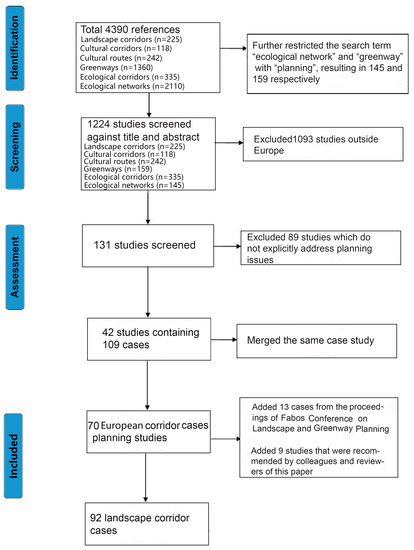
Figure 1.
Methodological diagram of the process of selecting cases for systematic review.
We screened all abstracts and selected those papers that were likely to describe planning and management studies of European corridors. A total of 131 studies remained after this selection.
Next, we read the full texts of these 131 studies and excluded all papers that did not explicitly address planning and management issues. This process left us with 42 papers that describe 109 corridor cases. Subsequently, we merged all papers that were dedicated to the same corridor and disaggregated papers that addressed more than one corridor. For example, the greenway in Porto has been examined in several papers. We stored all studies in an Endnote X7 [40] database.
In addition to corridors analysed in the literature, we identified an additional 13 European corridors from the proceedings of the Fabos Conference on Landscape and Greenway Planning [41]. We later investigated and incorporated the data from nine additional studies that were recommended by colleagues and reviewers of this paper. Our final sample thus included 92 landscape corridors from 25 European countries. Figure 2 visualizes the distribution of these corridors across Europe; details of each case are presented in Appendix A. We reviewed the 92 cases and recorded their primary information, including planning aims, problems, approaches and tools, stakeholders, and spatial scales as the most frequently mentioned planning elements among these cases. Having identified relevant corridors, we then searched their websites. Technical and managerial information from these websites was integrated into our quantitative and qualitative analyses. We used the aims stated on websites to classify and analyse the corridors and their planning processes.
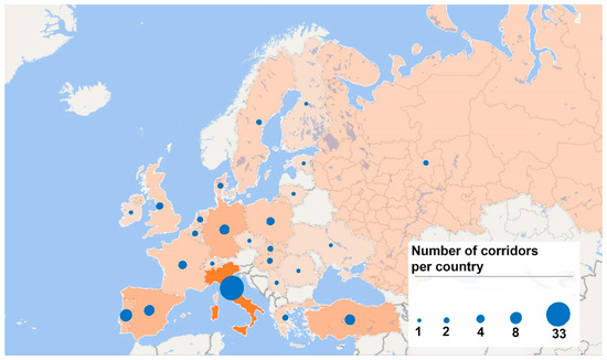
Figure 2.
Location and number of landscape corridors covered in this review, by country.
2.2. Classification of Landscape Corridors into Cultural or Ecological Categories
The cases were classified as cultural or ecological landscape corridors in a three-step process. First, we identified whether the primary aim of each case was cultural or ecological. A corridor was annotated as “cultural” when its major aim was to promote values like cultural heritage, identity, social relations, outdoor recreation, tourism or aesthetic values [42]. In contrast, we annotated a corridor as “ecological” when its primary aim was related to biodiversity conservation and/or regulating ecosystem services. On this basis, we identified 18 corridors as “primarily cultural” and 48 as “primarily ecological.” We annotated eight corridors as both cultural and ecological, while 18 did not include any explicit specifications of cultural or ecological objectives. Next, the names of the corridors were assessed to classify the remaining unclear cases. For example, corridors whose names included a variant of the word “ecology”, as it does in Cheshire ECO net, UK, see Table A1, No. 91, were classed as members of the ecological corridor group. Finally, the remaining ambiguous cases were classified by exploring their respective context comprehensively. For instance, the Apulia greenway plan was classified as a cultural landscape corridor after in-depth analysis identified “historical heritage conservation” as its main feature, see Table A1, No 23. Among the 92 European landscape corridors we identified, 26 were classified as “cultural corridors” and 66 as “ecological corridors.”
2.3. Analysis and Interpretation of Data
After classifying all the studied cases into cultural or ecological corridors, we sought patterns within and between them: problems addressed, approaches and tools used, stakeholders involved in corridor management and planning, and spatial scales of the corridors. We first submitted all recorded parameters within the aforementioned four aspects to ordination analysis based on non-metric multidimensional scaling (NMDS). The resulting Figure (in Section 3.2.) offers a visualization of the overall differences between the two types of corridors. We then tested for significant differences between the two types of corridors for each parameter. This was performed by a Chi-square test for binary data (i.e., did or did not address the specific problem) and by the non-parametric Mann-Whitney U test and T-test for numeric data (i.e., number of stakeholder types and spatial scales). Finally, we carried out qualitative analyses of representative cases of each type.
3. Results
3.1. Aims of Landscape Corridors
The explicit aims underlying the planning and management of the landscape corridors varied considerably among the cases, both within and between groups. Landscape corridor aims ranged from wildlife conservation to public recreation. In our study, the categorization of the landscape corridor aims was mainly based on the ecosystem services (ES) framework developed by the Millennium Ecosystem Assessment [43], which covers aesthetic values, cultural heritage, education, provisioning services (material benefits), genetic resources (biodiversity conservation), recreation and ecotourism, regulating ecosystem services, sense of place and social relations. All corridors pursued more than one aim and, at least superficially, some aims appeared to be in conflict with others.
Figure 3 indicates that biodiversity conservation (67%) and recreation and ecotourism (62%) represented the most frequently mentioned aims in the examined cases. Aesthetic values and provisioning services (material benefits such as food production) were rarely considered during landscape corridor planning.
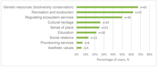
Figure 3.
Aims of landscape corridor cases.
The Lambro River Valley greenway system served multiple aims, see Table A1, No 26. The project was designed as a river valley park with the aim to preserve ecological and cultural-historical elements. The project sought to reconcile the existing system of routes, trails and rural roads and their historical and natural values, and to enhance the recreational centres and tourist places. The Pavia greenway system, see Table A1, No. 28, was another example of a corridor that targeted diverse aims. This greenway was planned to improve cycling mobility and to connect open spaces and scenery. The Pavia corridor also addressed cultural heritage conservation and biodiversity conservation, as well as recreation and ecotourism.
3.2. Comparison of Cultural and Ecological Corridors
After aggregation via NDMS (Non-metric multidimensional scaling) analysis, the resulting Figure 4 shows that variables related to cultural corridors were largely contained within the much more diverse group of ecological corridors. Still, the overall collected information (statuses on seven problems, ten approaches, ten types of stakeholders, and scales of the corridors) revealed a modest separation between the two categories, see Figure 4. A detailed comparison of each studied aspect was analysed below.
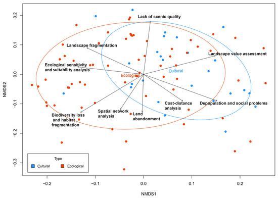
Figure 4.
Dissimilarity between corridors: Problems addressed (e.g., landscape fragmentation), approaches (e.g., ecological sensitivity and suitability analysis), number of stakeholders, stakeholder type and corridor size. Each case is represented by a dot (cultural corridors are represented by blue dots, ecological corridors by red dots). All variables are represented by a distance index between cases in a non-metric multidimensional scaling (NMDS) ordination plot. The ordering of the cases is represented in two dimensions (NMDS1, NMDS2). Arrows indicate the main variables explaining the ordination (p = 0.001) parameters recorded in this study.
3.3. Problems Addressed
Various problems were raised during the planning and management of landscape corridors. We recorded and aggregated these problems and challenges into the following categories: Landscape fragmentation, lack of scenic quality, urban expansion, biodiversity loss and habitat fragmentation, depopulation and social problems (e.g., lack of regional identification due to regional socio-economic decline), disaster risk (e.g., floods) and land abandonment. The relative importance of these variables in European landscape corridors is presented in Figure 5. The main problems that landscape corridors sought to address were landscape fragmentation (61%), lack of scenic quality (34%) and urban expansion (28%). Chi-square tests showed no significant differences between the cultural and ecological landscape corridor groups in the six mentioned problems (in each group, p > 0.05, n=92); although, cultural corridors addressed depopulation and social problems more often than ecological corridors (35% vs. 20%).
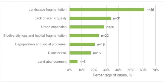
Figure 5.
Problems and issues addressed by landscape corridors (n = 92).
The Tomar urban greenway in Portugal, see Table A1, No. 65, was developed alongside the Nabao River, which featured significant natural and cultural resources that were threatened by recurrent heavy rainfall and flooding. Thus, project planners emphasised the importance of establishing vegetation along the riverbanks to counteract significant water flow in the river. The Lagonegro-Sicignano Greenway, see Table A1, No. 44, in Italy was built as a response to problems linked to the depopulation of inland villages (with a resulting cultural and social loss). The corridor was planned along an abandoned railway line and highlights local industrial history; the plan also included the rehabilitation of surrounding villages through tourism.
3.4. Planning and Managing Approaches and Tools
A variety of methods and approaches were used for planning and managing landscape corridors. Geographic Information System (GIS) analysis—often together with cost-distance analysis, graph-based analysis and spatial network analysis—was the most widely employed approach. Other approaches involved landscape value assessment, ecological sensitivity and suitability analysis, and analysis using historical map and satellite imagery, see Figure 6. These approaches were also often combined with GIS to analyse locations and patterns of heritage and historical places, the evolution of landscapes, places with culturally specific and unique landscape values, and zones with varying degrees of ecological sensitivity. To complete the list, planners and managers also used cost-distance analysis, multi-criteria decision analysis (MCDA, which structures and solves decision and planning problems that involve multiple criteria [44]), spatial network analysis, urban memory design (design of public spaces and cityscapes, which records urban history and reminds people of social memory and urban identity [45]), interviews and questionnaires (to collect public value and judgement), and graph-based analysis. GIS was found to be the most-used approach (82%), followed by ecological sensitivity and suitability analysis (26%) and landscape value assessment (21%). Interview-based approaches were rarely used in case practice (3%). Chi-square tests revealed statistically significant differences between cultural and ecological landscape corridors with respect to the use of historic maps and satellite images (X2 = 8.659, p = 0.003, n = 92), ecological sensitivity and suitability analysis (X2 = 12.359, p = 0.0005, n = 92), and landscape value assessment (X2 = 10.485, p = 0.001, n = 92).
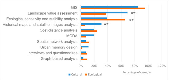
Figure 6.
Variation in approaches used in cultural and ecological landscape corridor analysis. The asterisks indicate the significance level: ** means p ≤ 0.01. MCDA, multi-criteria decision analysis; GIS, Geographical Information System.
In practice, several of the approaches might overlap (e.g., GIS and historic map analysis), but the purpose of this analysis was to show the diversity of approaches and the possible differences between cultural and ecological corridors concerning the approaches applied. In the case of the transhumance routes in Castel di Sangro-Lucera, Italy, see Table A1, No. 24, historic maps from the 17th century, present-day satellite imagery and GIS were employed to identify the needs and options for conservation and restoration. This case was located on a historically significant cultural route. In the Trabzon greenway, see Table A1, No. 88, both MCDA and GIS approaches were used to solve spatial decision problems linked to the corridor.
3.5. Stakeholders Involved
We also sought to understand the degree of participation by different stakeholders in the planning and management processes of landscape corridors. Stakeholder types included decision makers (e.g., representatives of governments or public agencies), residents and their associations (e.g., residents, landowners), and other participants (e.g., planners, consultants and researchers) (Figure 7). “Planning offices and boards” referred to companies that provide professional planning and consulting services. “Local associations” were organizations and NGOs (Non-governmental organizations) without a business purpose, such as habitat conservation associations or bird watching associations.
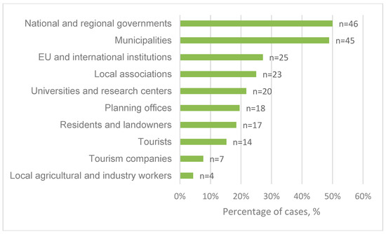
Figure 7.
Stakeholder involvement in landscape corridor planning and management, by stakeholder type.
The most common stakeholders participating in many landscape corridors were national and regional governments (47%) and municipal governments (43%, see Figure 6). These stakeholders were found to be actively involved in both cultural and ecological landscape corridors. The involvement of the local population and associations, including residents and landowners (18%), agricultural and industrial workers (4%), and tourism stakeholders (tourists 15%, tour companies 8%), was far lower than that of decision makers from governments. Chi-square tests indicated no significant differences between cultural and ecological corridors for the individual stakeholder types (in each group, p > 0.05, n = 92).
The Lower Saxony ecological network was initiated by the regional government in cooperation with research centres and local associations, see Table A1, No. 13. In this case, the preferences and knowledge of the landowners and agricultural and industrial workers clearly contributed to the decision-making process. The planning process for the Swedish agricultural greenway system, see Table A1, No. 81, was greatly influenced by the preferences of visitors and the attitudes of landowners regarding visitor access to their land, as determined by public meetings and surveys. The municipalities and the County Administrative Board were also involved in the process of making the agricultural landscape more attractive and accessible for recreation.
Additionally, we analysed the number of stakeholder types involved in the planning and management of each corridor, in order to explore which corridor types attract broader social networking and thus might require more cooperation during the planning process. Some cases attracted more cooperation among complex types of stakeholders. For example, planning for the Green River ecological corridor, see Table A1, No. 57, involved all (n = 5) types of stakeholder, i.e., the regional government, EU institutions, local associations, tour companies and research centres.
Generally, fewer than 10% of European landscape corridor plans had to reconcile the interests of five kinds of stakeholders during the planning period. Only one or two stakeholder types participated in the planning of the majority (69%) of cultural landscape corridors, while more than half of the ecological landscape corridor plans (58%) reflected the interests of three or more types of stakeholders. When using a Mann-Whitney U test to explore the differences between the two corridor categories regarding the number of stakeholders, we found a significant difference (U = 586, p = 0.011, n = 92). Ecological landscape corridors generally involved more diverse stakeholder types (mean = 2.53) than cultural landscape corridors (mean = 2.07).
3.6. Spatial Scale
The impact of a landscape corridor depends greatly on the scale at which it is planned, developed and managed [46]. We found that ecological networks were the most area-extensive type of landscape corridor. Among cases studied, the most extreme was the national ecological network in Russia, which covers 22.4 million km2, see Table A1, No. 71. The smallest ecological network, which covers only 25,000 km2, linked existing parkways and habitats for recreational purposes and natural resource conservation in the County of Cheshire in the UK, see Table A1, No. 91.
The boxplot, see Figure 8, presents the length ranges and the distribution of cultural and ecological corridor cases. Europe’s cultural landscape corridors generally had a smaller spatial scale than the ecological landscape corridors; although, there was considerable variation within the ecological group. Figure 8 indicates that the length of cultural landscape corridors ranged from 4 km to 600 km, while that of ecological landscape corridors varied from 2.4 km to 3000 km. T-tests indicated a significant difference between the length scale of ecological corridors and that of cultural corridors (t = −2.6844, p = 0.0086, n = 92).
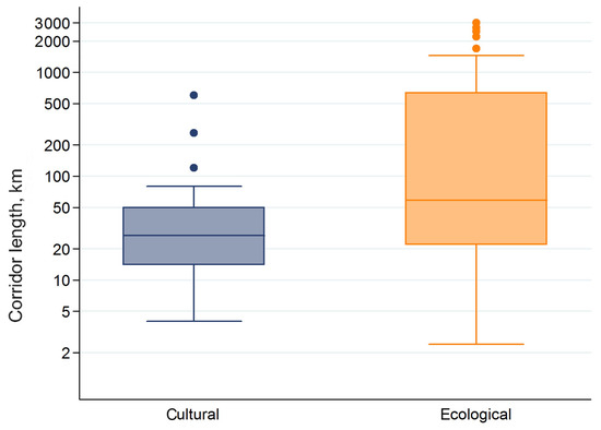
Figure 8.
Boxplot of the lengths of cultural and ecological corridors (in kilometers).
The length of the corridors was also worth considering. The cultural landscape corridor of the Alto Douro Wine Region greenway in Portugal, see Table A1, No. 67, which protected the biophysical and cultural features of the oldest wine-making region in the world, stretched to nearly 70 km. The Fennoscandia Green Belt, see Table A1, No. 7, extended along the border between Finland, Russia and Norway, covering a length of around 1000 km. This ecological landscape corridor promoted international cooperation on the conservation of natural habitat areas.
4. Discussion
4.1. What are Landscape Corridors About?
Landscape corridors are receiving increasing policy attention with the rise of Green Infrastructure strategies. This interest has been reflected by a growing number of research publications, as shown in our review. Since the 1990s, various policy initiatives have embraced the concept of landscape corridors, such as the European Landscape Convention [47] or the proposal for a Pan-European Ecological Network [48]. Our review revealed that the most frequent aims of landscape corridors were biodiversity conservation and recreation. Most corridors were planned and designed for pursuing multiple goals, such as preserving cultural heritage and regulating ecosystem services. This variety of aims was a strong expression of the multi-functionality of corridors and the integration of multiple policies. Blurred goals might also lead to unfocused decisions and unclear criteria for measuring success. However, this problem can be dealt with through carefully organized scoping [49].
4.2. What are the Differences between Cultural and Ecological Corridors?
Our analysis showed that both cultural and ecological corridors face complex problems. The most common problems identified were landscape fragmentation, lack of scenic quality and urban expansion. Our statistical analysis showed that corridor planners face essentially the same kinds of problems, regardless of the corridor type. Coping with these problems holistically requires process design, which provides ownership and clarification of the stated aims and objectives [50].
Our review revealed significant differences between cultural and ecological corridors in respect to the planning approaches and tools used. Specifically, analysis of historical maps and satellite images and landscape value assessment were most frequently used in cultural corridors. In contrast, GIS, in combination with ecological sensitivity and suitability analysis, was the most common approach for ecological corridor planning. More frequent exchanges on planning approaches and tools between cultural and ecological corridors may be fruitful; for example by providing cultural history insights into ecological corridor planning to better understand the restoration potential of former habitats [49].
Generally, the types of stakeholders involved in the planning processes were similar in cultural and ecological corridors; governments and municipalities played the most powerful roles in the planning of both corridor types. Significant differences appeared in the number of types of stakeholders who engaged in cultural versus ecological corridors. However, a wider variety of stakeholder groups engaged with ecological corridors rather than with cultural corridors. This may indicate that ecological corridors are better linked with more diverse social networks, often also including the EU and other international institutions. Planning and management of cultural corridors may be strengthened in the future by broadening stakeholder support networks in a similar manner [49].
The most significant difference between cultural and ecological corridors we found in this review was in their spatial scales. Ecological corridors were more varied and generally larger than cultural corridors, which existed at a smaller scale. This makes sense, as human passage typically takes place on a smaller scale. As scale increased, the amount of attention to ecological issues also increased; ecological goals, most notably biodiversity conservation, were at the heart of all large-scale corridors. However, as pressures on cultural and ecological corridors arise from multiple scales, both should integrate a variety of scales. For instance, cultural landscape corridor planning could be promoted broadly as a way to preserve the heritage associated with cross-regional cultural routes.
Both quantitative and qualitative analysis showed that cultural and ecological corridors were broadly similar in terms of problems addressed, stakeholder types and planning approaches. This consonance might be explained by the fact that planners of landscape corridors often try to reach multiple aims simultaneously, thus creating multifunctional landscapes that serve many purposes. Our analysis indicates that ecological corridors are often more elaborate and diverse in terms of the stakeholders involved and spatial scales considered.
4.3. How to Bring Landscape Corridor Planning and Management in Europe Forward?
Our review revealed that landscape corridor planning was not only on the European Union’s policy agenda but also attracted interest at all levels of government and civil society. The number of corridor projects is clearly on the rise. Against this background, we see the consistently low number of plausibly relevant stakeholders who are included in current planning practices as a major shortcoming. Too many interests, ideas and political and social capital that could improve the corridor projects have, therefore, not been harnessed. Previous studies have shown that public participation can be an effective tool in landscape planning and management. In addition, the European Landscape Convention corroborates the beneficial roles of public participation in the implementation of such projects and highlights that potential ideas and suggestions might be overlooked otherwise [51]. Hence, here, we consider ways to make better use of stakeholder resources during the project planning stage. Inspired by Healey’s four dimensions of spatial strategy making [52], we offer recommendations for overcoming the lack of public participation and limitation of knowledge resources:
- Creating broad interest among stakeholders: Several innovations can help to focus attention on landscape corridors as a whole process. For instance, the Danish experience suggests that lectures, group discussions and seminars are effective in attracting attention and sharing knowledge of places [53]. Additionally, reference to similar successful projects can provide clear and concrete ideas on planning new projects and how they should be conducted. Creating attention and broad interest in a corridor project entails the involvement of multiple types of stakeholders, such as farmers, conservation groups, relevant public institutions, tourists and tour companies. Widening the networks and mobilizing the attention should involve all relevant stakeholders including governments, NGOs, private stakeholders and various other organizations.
- Scoping: Setting the goals and focusing on the particular situation of landscape corridor planning are important to the scoping process. They help decision-makers clarify the starting points of the project as well as the direction of future development. Addressing questions like ‘where are we now?’ and ‘where did we come from?’ helps decision makers to trace back the history of local development, organize existing resources and define current statements. The majority of studies reviewed in this article have stated their goals and key questions only to a limited extent. Besides clarifying the objectives, determining the appropriate scope of a project also requires an overall evaluation of expectations, obstacles and potential conflicts, as well as a clear plan to achieve a balance among multiple objectives.
- Mobilizing knowledge, ideas, experiments and other resources: This dimension is concerned with increasing knowledge by using all available resources. Decision makers should be free to use and combine multiple forms of knowledge, from both experts and the public. Professional skills and expert knowledge can be crucial to effective landscape corridor planning. Lay people can also provide local and contextualized knowledge that is relevant to the planning process. Workshops, expert lectures and public discussions can create a common understanding of a landscape corridor [53]. In addition, when a corridor will be funded with public money, early and genuine incorporation of the public can deflect political challenges that might appear later in the process. Planning experiments can also be useful. Experimental platforms provide space for testing new technologies and design solutions. In addition to human resources, corridor planners are urged to pay even greater attention to the physical resources at their disposal. For example, a vacant building may be useful as an interpretation centre, and an abandoned water tower could be repurposed as a bird-watching tower.
- Framing carefully: Framing entails producing a convincing plan to present and promote the main ideas and values to the public [54]. It helps decision makers to summarize the main ideas of a landscape corridor by identifying the planning strategy. It highlights the characteristics of each case and provides an easier way to communicate with the public, thereby creating a greater interest. A good frame starts with a good name. Fenno-Scandinavia’s “Green Belt”, an extraordinary corridor that spans from Norway through much of Finland and into Russia, is a good example of such framing as it provides a useful concept and vision for this spatial development. For systematic considerations, framing identifies the dominant focus from multiple perspectives for a planning project.
5. Conclusions
Our study summarized the knowledge, experience and weaknesses of recent landscape corridor plans published in Europe. The analysed corridors revealed a wide diversity in substance and process. The distinction between ecological and cultural types of corridors proved to be useful for describing the major patterns in corridor planning and for summarizing the experiences in natural and cultural heritage conservation; although, many corridors have included both dimensions in their plans.
The most widely shared aims guiding corridor plans appeared to be biodiversity conservation, recreation and tourism, and cultural heritage. Underlying these aims are perceived problems such as landscape fragmentation, biodiversity loss, lack of scenic quality, urban expansion and depopulation. GIS-based analysis, together with landscape assessment, historical analysis and ecological sensitivity and suitability analysis are among the most-used analytical methods. Moreover, relatively few stakeholders outside public institutions are generally involved in these processes.
There are clear indications that ecological corridors are more elaborate and diverse in terms of the planning approaches used, stakeholder types involved and spatial scales considered. These approaches may be further improved by expanding public participation and developing collaborative approaches to planning.
However, some potential similarities between cultural and ecological landscape corridors remain, making the complete separation of the two categories infeasible, despite the many differences that our research exposed. In particular, our analysis shows that classification based on aims might not represent the best way to categorise landscape corridors. Further development of the study methodology is needed to group landscape corridors more effectively.
To sum up, we regard this review as an initial step towards achieving a better understanding of the functionality of landscape corridors and their planning and management. It also offers inspiration for future planning strategies with respect to GI and various types of landscape corridors.
More research is required to promote the strategy-making process and the implementation of landscape corridors. The following aspects are proposed for future research: (1) To develop approaches to mobilize collaborative place making and public participation in future corridor planning; (2) to analyse the contribution made by different corridor types to habitat conservation, heritage protection and management; (3) to create assessment tools for the spatial integration of aims associated with biodiversity, heritage conservation, aesthetics, recreation and the specific interests of various stakeholders, including the general public, professionals and decision-makers; and (4) to evaluate landscape corridors and corridor planning fully from ex-post to ex-ante.
Author Contributions
Writing—Original Draft Preparation, H.X.; Writing—Review & Editing, T.P. and J.P.; Supervision, T.P. and J.P.
Conflicts of Interest
The author declares no conflicts of interest.
Appendix A
Table A1.
Europe’s 92 landscape corridors.
Table A1.
Europe’s 92 landscape corridors.
| No. | Name | Country | Aims | Stakeholders | Problems | Approaches and Tools | Source |
|---|---|---|---|---|---|---|---|
| 1 | Flemish Ecological Network | Belgium | Biodiversity conservation, Regulating ecosystem services | Regional governments, Planning offices | Landscape fragmentation, Habitat fragmentation | GIS, Landscape value analysis | [55] |
| 2 | Walloon Ecological Network | Belgium | Regulating ecosystem services, Biodiversity conservation | Regional governments, Planning offices | Urban expansion, Landscape fragmentation | GIS, Cost distance analysis, Landscape value analysis | [56] |
| 3 | Czech Territorial Ecological Network System | Czech | Regulating ecosystem services, Biodiversity conservation | Tourists, Residents, Regional governments, Local associations | Landscape fragmentation | GIS, Landscape value analysis | [57,58] |
| 4 | Denmark Ecological Networks/Naturverbindsele | Denmark | Biodiversity conservation | Regional governments, Tourists, Residents | Landscape fragmentation, Biodiversity loss, Habitat fragmentation | GIS, Ecological sensitivity and suitability analysis | [56,59] |
| 5 | Aarhus Greenway | Denmark | Provisioning services, Regulating ecosystem services | Municipalities, Residents, Planning offices | Urban expansion | GIS, Landscape value assessment, Survey and interview analysis | [60] |
| 6 | Network of Compensative Areas | Estonia | Sense of place, Regulating ecosystem services, Biodiversity conservation | EU and international institutions, Regional governments, Planning offices | Landscape fragmentation, Biodiversity loss, Habitat fragmentation | GIS, Ecological sensitivity and suitability analysis | [56,61] |
| 7 | Fennoscandia Green Belt | Finland, Russia | Biodiversity conservation, Recreation and ecotourism, Education | Tour companies, EU and international institutions, Tourists | Landscape fragmentation | GIS, ecological satellite imagery, Ecological sensitivity and suitability analysis, MCDA | [62,63] |
| 8 | Marseille Urban Greenway | France | Recreation and ecotourism, Regulating ecosystem services | Municipalities, Research centres, Local associations | Landscape fragmentation, Poor scenic quality | Ecological sensitivity and suitability analysis, GIS | [64] |
| 9 | Angers Green Infrastructure | France | Recreation and ecotourism, Regulating ecosystem services | Municipalities, Residents | Urban expansion, Landscape fragmentation, Poor scenic quality | GIS, Satellite images, Ecological sensitivity and suitability analysis, Spatial network analysis | [65] |
| 10 | Ecological networks from the Cantabrian Range to the Western Alps | France, Italy, Spain, | Biodiversity conservation, Regulating ecosystem services | Research centres and universities, EU and international institutions, regional and national governments | Biodiversity loss, Habitat fragmentation, Land abandonment, Urban expansion | GIS, Ecological sensitivity and suitability analysis, Value assessment, Spatial network analysis | [66] |
| 11 | Champs-Elysées axis related to Seine River | France | Cultural heritage, Aesthetic values, Recreation and ecotourism, Education | Tourists, Municipalities | Poor scenic quality | Urban memory design | [45] |
| 12 | LaPro Greenway, Berlin | Germany | Biodiversity conservation, Recreation and ecotourism, Regulating ecosystem services, Education | Municipalities, EU and international institutions | Urban expansion, Landscape fragmentation, Depopulation and social problems | GIS Cost distance analysis, Urban memory design, Landscape value assessment | [60] |
| 13 | Lower Saxony Ecological Network | Germany | Biodiversity conservation, Regulating ecosystem services | Research centres and universities, Regional governments, Local associations | Landscape fragmentation, Biodiversity loss, Habitat fragmentation | GIS ecological sensitivity and viability analysis, graph analysis | [67] |
| 14 | Kronsberg Greenbelt | Germany | Biodiversity conservation, | Municipalities, Regional governments, Local associations, Agricultural and industrial workers | Landscape fragmentation, Disaster risk, Poor scenic quality, | GIS, Ecological sensitivity and suitability analysis, Landscape value assessment | [68] |
| 15 | German greenbelt ecological network system | Germany | Sense of place, Regulating ecosystem services, Biodiversity conservation | National and Regional governments, EU and international institutions | Depopulation and social problems, Urban expansion | GIS, Ecological sensitivity and suitability analysis, Landscape value analysis | [68,69] |
| 16 | Planung vernetzter Biotopsysteme | Germany | Regulating ecosystem services, Biodiversity conservation | Regional governments | Landscape fragmentation, Disaster risk | GIS, Ecological sensitivity and suitability analysis | [56,70] |
| 17 | Saale-Unstrut cultural landscape corridor | Germany | Recreation and ecotourism, Sense of place, Social relations, Cultural heritage, Landscape preservation | Local associations | Depopulation and social problems, Land abandonment | Urban memory design | [4] |
| 18 | Edessa Greenways | Greece | Recreation and ecotourism, Sense of place, Regulating ecosystem services, Cultural heritage | Municipalities, Research centres and universities | Depopulation and social problems | GIS, historical map, visual analysis, Cost distance analysis, Landscape value, Resource assessment | [71] |
| 19 | Agrinio – Lysimachia Greenway | Greece | Recreation and ecotourism, Provisioning services, Cultural heritage, Sense of place | National governments | Landscape fragmentation, Biodiversity loss, Habitat fragmentation, Land abandonment | GIS, Spatial network analysis, Ecological sensitivity and suitability analysis, Cost distance analysis, Landscape value assessment | [72] |
| 20 | Budavidék Greenway | Hungary | Recreation and ecotourism, Provisioning services, Cultural heritage, Sense of place | Residents, Tourists, Research centres and universities, Regional governments | Landscape fragmentation, Depopulation and social problems | GIS, Survey and interview analysis, Landscape value assessment | [73] |
| 21 | Baranya Greenway | Hungary | Recreation and ecotourism, Sense of place, | Tourists, EU and international institutions, Local associations | Depopulation and social problems, Disaster risk | GIS, Landscape value assessment | [74] |
| 22 | Westmeath Royal Canal Greenway | Ireland | Provisioning services, Recreation and ecotourism, Cultural heritage | National and regional governments, Local associations | Landscape fragmentation, | Landscape value assessment, MCDA, GIS | [75,76] |
| 23 | Apulia greenway | Italy | Recreation and ecotourism, Sense of place, Social relations, Cultural heritage, Provisioning services, Regulating ecosystem services | Residents, Agricultural and industrial workers, Research centres and universities | Poor scenic quality, Landscape fragmentation | MCDA, GIS, Graph-based analysis | [77,78] |
| 24 | Castel di Sangro-Lucera, transhumance network | Italy | Cultural heritage, Aesthetic values, Sense of place | Residents and landowners, Municipalities | Poor scenic quality | GIS, historic maps and satellite imagery | [79] |
| 25 | Corona Verde Strategic Plan | Italy | Cultural heritage, Social relation, Aesthetic improvement, Biodiversity conservation, Regulating ecosystem services | EU and international institutions, Residents and landowners | Poor scenic quality, Landscape fragmentation, | GIS, Landscape value assessment | [80] |
| 26 | Lambro River Valley Greenways System | Italy | Recreation and ecotourism, Cultural heritage, Education, Regulating ecosystem services, Biodiversity conservation | Regional governments, Local associations | Landscape fragmentation, Biodiversity loss, Habitat fragmentation | Ecological sensitivity and suitability analysis, Satellite imagery, GIS | [81] |
| 27 | Ora-Predazzo Railway Greenway | Italy | Recreation and ecotourism, Regulating ecosystem services | Tour companies | Depopulation and social loss, Land abandonment | GIS, Urban memory design, Cost distance analysis | [82] |
| 28 | Pavia Greenway | Italy | Recreation and ecotourism, production, Cultural heritage and Biodiversity management | Municipalities, Research centres and universities | Landscape fragmentation, Biodiversity loss, Habitat fragmentation | GIS, Landscape value assessment | [83] |
| 29 | Calalzo Greenway | Italy | Recreation and ecotourism, Regulating ecosystem services, Education | Local associations, EU and international institutions | Urban expansion, Disaster risk | GIS, Ecological sensitivity and suitability analysis | [84] |
| 30 | Greenway Arco Ligure | Italy | Regulating ecosystem services, Biodiversity conservation | Municipalities, Local associations, Planning offices | Landscape fragmentation, Poor scenic quality, Depopulation and social problems | GIS, Ecological sensitivity and suitability analysis, Cost distance analysis | [85,86] |
| 31 | Greenway del Naviglio Martesana | Italy | Recreation and ecotourism, Regulating ecosystem services | Regional governments, Municipalities | Poor scenic quality, Urban expansion | GIS, Landscape value assessment, Cost distance analysis, graph, Ecological sensitivity and suitability analysis | [86,87] |
| 32 | Greenway del Naviglio Grande | Italy | Recreation and ecotourism, Cultural heritage, Social relations, | Regional governments, Municipalities | Poor scenic quality, Urban expansion | GIS, Ecological sensitivity and suitability analysis, Landscape value assessment | [86,88] |
| 33 | Greenway della Battaglia | Italy | Recreation and ecotourism, Education, | Municipalities, Local associations, Tourists | Poor scenic quality, Urban expansion | GIS, Ecological sensitivity and suitability analysis, MCDA | [86,89] |
| 34 | Greenway Medio Olona | Italy | Recreation and ecotourism, Education, Biodiversity conservation | Agricultural workers, Regional governments | Landscape fragmentation, Poor scenic quality | GIS, Ecological sensitivity and suitability analysis Landscape value assessment, Cost distance analysis | [86,90] |
| 35 | Greenway del canal della Muzza | Italy | Provisioning services, Regulating ecosystem services, Biodiversity conservation | Tourists, Tour companies, Regional governments, Local associations, EU and international institutions | Landscape fragmentation, Poor scenic quality | GIS, Historical map analysis | [86,91] |
| 36 | Greenway della ex ferrovia Val Seriana | Italy | Recreation and ecotourism, Biodiversity conservation | Municipalities | Landscape fragmentation, Poor scenic quality, Depopulation and social problems | GIS, Landscape value assessment, Ecological sensitivity and suitability analysis | [86,92] |
| 37 | Greenway del lago di Como | Italy | Recreation and ecotourism, Biodiversity conservation | Regional governments, Tour companies | Landscape fragmentation, Poor scenic quality | GIS Ecological sensitivity and suitability analysis, Landscape value assessment | [86,93] |
| 38 | Greenway Milano –Varzi | Italy | Provisioning services, Recreation and ecotourism, Education, Regulating ecosystem services | Municipalities and regional governments, EU and international institutions | Landscape fragmentation, Poor scenic quality | GIS, Ecological sensitivity and suitability analysis, Landscape resources and value assessment | [86,92] |
| 39 | Greenway del Parco Adda | Italy | Recreation and ecotourism, Biodiversity conservation | Municipalities, Local associations, Tour companies | Urban expansion, Disaster risk, Poor scenic quality | GIS, Cost distance analysis | [86,94] |
| 40 | Greenway del Vingone | Italy | Recreation and ecotourism, Education, Biodiversity conservation | Research centres and universities, Municipalities, Tourists | Disaster risk, Depopulation and social problems | Cost distance analysis based on trails, GIS | [86,95] |
| 41 | Greenway Tracciato della Norcia Spoleto | Italy | Recreation and ecotourism, Education, Biodiversity conservation | Municipalities | Disaster risk, Urban expansion | GIS, Ecological sensitivity and suitability analysis | [86,96] |
| 42 | Greenway Pista ciclabile | Italy | Recreation and ecotourism, Sense of place | Municipalities | Poor scenic quality, Urban expansion | GIS, Ecological sensitivity and suitability analysis | [86,97] |
| 43 | Greenway Vasto-San Salvo | Italy | Biodiversity conservation, Regulating ecosystem services | Regional governments, Municipalities | Poor scenic quality, Urban expansion | GIS, Ecological sensitivity and suitability analysis | [86,98] |
| 44 | Greenway Lagonegro-Sicignano | Italy | Recreation and ecotourism, Cultural heritage | Municipalities, Research centres and universities, Local associations | Depopulation and social problems | Historical map analysis, Landscape value assessment | [86,99] |
| 45 | Le vie “Verdi” di Puglia | Italy | Cultural heritage, Provisioning services, Social relations, Sense of place | Regional governments, Planning offices | Depopulation and social problems | Cost distance analysis, Landscape value assessment, GIS, Ecological sensitivity and suitability analysis | [86,100] |
| 46 | Greenway degli Erei | Italy | Recreation and ecotourism, Provisioning services | Regional governments, Municipalities, Local associations | Landscape fragmentation, Poor scenic quality | GIS, Ecological sensitivity and suitability analysis, Landscape value assessment | [86] |
| 47 | Greenway of an unused railway, Siracusa-Vizzini | Italy | Recreation and ecotourism, Sense of place, Provisioning services | Regional governments, Residents, Municipalities | Poor scenic quality, Urban expansion | GIS, Ecological sensitivity and suitability analysis, Cost distance analysis, Landscape value assessment | [101] |
| 48 | Lombardy historic canal corridor | Italy | Social relations, Recreation and ecotourism, Regulating ecosystem services | Municipalities and regional governments | Depopulation and social problems, Biodiversity loss, Habitat fragmentation | GIS, historical map, Ecological sensitivity and suitability analysis, Landscape value assessment | [47] |
| 49 | Ecological Network of Nuoro (ENN) | Italy | Biodiversity conservation, Regulating ecosystem services | Municipalities, Research centres and universities, EU and international institutions | Urban expansion, Biodiversity loss, Habitat fragmentation | GIS, Spatial network analysis, Satellite images, Ecological sensitivity and suitability analysis | [102] |
| 50 | Valsugana Valley | Italy | Biodiversity conservation, Regulating ecosystem services | Municipalities, universities and research centres | Biodiversity loss, Habitat fragmentation, Landscape fragmentation | GIS, Survey, interviews and workshop, MADM (multi-attribute decision) | [103] |
| 51 | Cuneo ECONNET | Italy | Biodiversity conservation, Regulating ecosystem services | Regional governments, EU and international institutions | Biodiversity loss, Habitat fragmentation, Landscape fragmentation | GIS graph-based analysis, Ecological sensitivity and suitability analysis | [104] |
| 52 | Ecological networks in Reggio Calabria | Italy | Biodiversity conservation, Regulating ecosystem services | Regional governments, | Biodiversity loss, Habitat fragmentation, Landscape fragmentation | GIS graph-based analysis, Ecological sensitivity and suitability analysis | [104] |
| 53 | Adige River Corridor | Italy | Biodiversity conservation, Regulating ecosystem services | Municipalities | Disaster risk | GIS, Ecological sensitivity and suitability analysis | [105] |
| 54 | Greenway of along Po River | Italy | Biodiversity conservation | Municipalities, Planning offices | Landscape fragmentation, Depopulation and social problems | GIS, Ecological sensitivity and suitability analysis, Landscape value assessment | [83] |
| 55 | Nature Frame of Lithuania | Lithuania | Sense of place, Biodiversity conservation | Regional government, Residents, EU and international institutions | Depopulation and social problems, urban expansion, Poor scenic quality | GIS, Ecological sensitivity and suitability analysis | [106] |
| 56 | National Ecological Networks System | Netherlands | Biodiversity conservation | Regional governments, Planning offices, EU and international institutions | Landscape fragmentation and Disaster risk, Biodiversity loss, Habitat fragmentation | GIS, Ecological sensitivity and suitability analysis | [107] |
| 57 | Green River Ecological Corridor | Netherlands | Biodiversity conservation, Regulating ecosystem services, Recreation and ecotourism, Sense of place | National and regional governments, Research centres, EU and international institutions, Local associations, Tour companies | Urban expansion Landscape fragmentation, Biodiversity loss, Habitat fragmentation | Survey and interview analysis, GIS | [108] |
| 58 | Bialystok Historical greenways | Poland | Recreation and ecotourism, Cultural heritage, Biodiversity conservation | Regional governments | Landscape fragmentation, Poor scenic quality | GIS, Landscape value assessment | [109] |
| 59 | Wallachian Culture Trail Greenway, Gorce | Poland | Recreation and ecotourism, Education, Cultural heritage | Regional governments, Planning offices, Local associations | Urban expansion, Disaster risk, Poor scenic quality | GIS, Landscape value assessment | [110] |
| 60 | River Vistula Ecological Corridor | Poland | Regulating ecosystem services, Biodiversity conservation | EU and international institutions, research centres | Landscape fragmentation and fragmentation, Disaster risk | GIS, Landscape ecological analysis, Ecological sensitivity and suitability analysis | [111] |
| 61 | Polish National Ecological Network System | Poland | Regulating ecosystem services, Biodiversity conservation | Regional and national governments, EU and international institutions | Landscape fragmentation | GIS, Ecological sensitivity and suitability analysis | [112] |
| 62 | Almada Municipality Cycle Network | Portugal | Recreation and ecotourism, Regulating ecosystem services | Municipalities, research centres and universities, local associations | Poor scenic quality | GIS, Cost distance analysis, Ecological sensitivity and suitability analysis, Spatial network analysis | [113] |
| 63 | Sintra Greenway | Portugal | Biodiversity conservation, Cultural heritage, Recreation and ecotourism | Municipalities, Planning offices | Landscape fragmentation | Cost distance analysis, GIS, landscape value assessment, Spatial network analysis, Survey and interview analysis | [114] |
| 64 | Vila-Franca-de-Xira Hills Greenway | Portugal | Aesthetic values, Recreation and ecotourism, | Municipalities, Planning offices | Landscape fragmentation | Landscape value assessment | [114] |
| 65 | Tomar Cultural Greenway | Portugal | Aesthetic values, Recreation and ecotourism, Sense of place Cultural heritage, cultural conservation | Local associations, Planning offices, Residents | Landscape fragmentation, Biodiversity loss, Habitat fragmentation, Disaster risk | Landscape value assessment | [114] |
| 66 | Alpiarça Drainage Canal Greenway | Portugal | Biodiversity conservation, Cultural heritage, Recreation and ecotourism, Social relations, Sense of place | National governments, Planning offices | Disaster risk | MCDA, Landscape value assessment | [114] |
| 67 | Alto Douro Wine Region greenway | Portugal | Cultural heritage, Sense of place, Recreation and ecotourism | EU and international institutions, Local associations, research centres | Landscape fragmentation | GIS, Ecological sensitivity and suitability analysis, Landscape value analysis | [115] |
| 68 | River Greenway, Lisbon Metropolitan Area | Portugal | Recreation and ecotourism, Biodiversity conservation | Municipalities, Planning office, Residents | Landscape fragmentation, Abandoned land, Disaster risk | GIS, Ecological sensitivity and suitability analysis | [114] |
| 69 | Tagus River Corridor | Portugal | Social relations, Recreation and ecotourism, Sense of place, Biodiversity conservation | Municipalities, Residents | Depopulation and social problems, Landscape fragmentation, Poor scenic quality | GIS, Landscape value assessment, survey, Interviews and workshops | [116] |
| 70 | Romania: National ecological network | Romania | Biodiversity conservation, Regulating ecosystem services | National governments, EU and international institutions | Biodiversity loss and habitat fragmentation | GIS, ecological sensitivity and suitability analysis | [70] |
| 71 | Moscow Ecological Network | Russia | Biodiversity conservation | Regional governments, Tour companies, Tourists | Landscape fragmentation, Biodiversity loss, Habitat fragmentation | GIS, Ecological sensitivity and suitability analysis, Spatial network analysis | [70,117] |
| 72 | Subotica Greenway | Serbia | Recreation and ecotourism, Biodiversity restoration, Regulating ecosystem services, Education | Planning offices, Local associations | Urban expansion, Landscape fragmentation, Depopulation and social problems | GIS, Landscape value assessment, Cost distance analysis | [118] |
| 73 | South-Western Slovakia Greenway | Slovakia | Recreation and ecotourism, Provisioning services, Regulating ecosystem services | Municipalities and regional governments, Research centres and universities | Urban expansion, Landscape fragmentation | GIS, Landscape value assessment, Ecological sensitivity and suitability analysis | [119] |
| 74 | Territorial System of Ecological Stability | Slovakia | Provisioning services, Biodiversity conservation, Regulating ecosystem services | Municipalities, Residents | Landscape fragmentation, Urban expansion | GIS, Ecological sensitivity and suitability analysis, MCDA | [120] |
| 75 | Cartagena-La Unión Greenway | Spain | Recreation and ecotourism, Sense of place, Education | Landowners, Municipality | Land abandonment | GIS, MCDA | [44] |
| 76 | Vasco-Navarro Railway Corridor | Spain | Sense of place, Biodiversity conservation, Education, Recreation and ecotourism | Research centres, Planning offices, Local associations | Landscape fragmentation, Disaster risk, Depopulation and social problems | Cost distance analysis, GIS | [121] |
| 77 | Basque Country Ecological Networks | Spain | Biodiversity conservation, Regulating ecosystem services | Regional governments, EU and international institutions | Biodiversity loss, Habitat fragmentation, Land abandonment | GIS spatial network analysis, cost-distance analysis. | [122] |
| 78 | Catalonia Ecological Network | Spain | Biodiversity conservation, Regulating ecosystem services | Research centres and universities, EU and international institutions, regional and national governments | Landscape fragmentation | GIS, Ecological sensitivity and suitability analysis, Graph analysis, Spatial network analysis | [123] |
| 79 | Network of Natura 2000 woodland sites | Spain | Biodiversity conservation, Regulating ecosystem services | Regional governments, EU and international institutions, Universities and research centres | Biodiversity loss, Habitat fragmentation, Landscape fragmentation | GIS, Graph-based analysis, Spatial network analysis, Cost distance analysis | [124] |
| 80 | Urban green networks, Stockholm | Sweden | Biodiversity conservation, Regulating ecosystem services, Recreation and ecotourism | Municipalities and regional governments | Landscape fragmentation, Biodiversity loss, Habitat fragmentation | GIS, Spatial network analysis, Ecological sensitivity and suitability analysis | [125] |
| 81 | Agricultural Greenway System | Sweden | Recreation and ecotourism, Education, Biodiversity conservation | Landowners, agricultural and industrial workers, Tourists, Local associations | Biodiversity loss, Habitat fragmentation | Cost distance analysis, survey and interview | [126] |
| 82 | National Ecological Network | Switzerland | Biodiversity conservation, Regulating ecosystem services | Regional governments, EU and international institutions | Landscape fragmentation, Poor scenic quality | MCDA, GIS, Ecological sensitivity and suitability analysis | [127] |
| 83 | Gaziantep Corridors | Turkey | Recreation and ecotourism, Sense of place, Education, Cultural heritage, Provisioning services | Regional governments, Municipalities | Depopulation and social problems | GIS historical map Ecological sensitivity and suitability analysis | [128] |
| 84 | Toklu Valley Corridor | Turkey | Recreation and ecotourism, Biodiversity conservation, Regulating ecosystem services, Education | Municipalities, Residents, Tourists | Poor scenic quality, Urban expansion, Depopulation and social problems | GIS, Ecological sensitivity and suitability analysis, Landscape value assessment | [129] |
| 85 | Historical Green Corridors of the Golden Horn | Turkey | Recreation and ecotourism, Cultural heritage, Biodiversity management, Social relations, Education, Sense of place | Municipalities, Tourists, Research centres and universities | Landscape fragmentation, Disaster risk, Urban expansion | GIS, Cost distance analysis, Ecological sensitivity and suitability analysis, Landscape value assessment | [130] |
| 86 | Turkish Silk Road cultural route | Turkey | Recreation and ecotourism, Sense of place, Social relation, Cultural heritage | EU and international institutions, Research centres and universities, Regional governments | Depopulation and social problems | Historical map analysis, GIS, Landscape value assessment | [131] |
| 87 | Ankara Urban Greenway | Turkey | Social relations, Regulating ecosystem services | Municipalities | Landscape fragmentation, Poor scenic quality, Urban expansion, | GIS, Ecological sensitivity and suitability analysis, Landscape value assessment | [132] |
| 88 | Trabzon Greenway | Turkey | Recreation and ecotourism, Regulating ecosystem services, Cultural heritage, Biodiversity conservation, Social relations, Education | Municipalities | Landscape fragmentation, Poor scenic quality, Urban expansion | MCDA, GIS | [133] |
| 89 | Edinburgh Greenway | UK | Recreation and ecotourism, Regulating ecosystem services | Municipalities, Residents, Planning offices | Landscape fragmentation, Disaster risk | GIS Landscape value assessment, Survey and interview analysis | [60] |
| 90 | Scotland, Forest Habitat Network | UK | Recreation and ecotourism, Biodiversity conservation | Regional governments, Municipalities, Research centres | Biodiversity loss Habitat fragmentation, Landscape fragmentation, Poor scenic quality | GIS, Ecological sensitivity and suitability analysis | [70,134] |
| 91 | Cheshire County ecological networks; Cheshire ECO-net | UK | Biodiversity conservation, Regulating ecosystem services, Recreation and ecotourism | Regional governments, EU and international institutions | Landscape fragmentation, Biodiversity loss, Habitat fragmentation | GIS, Ecological sensitivity and suitability analysis, Linking of existing parkways | [135,136] |
| 92 | Ukraine: National Ecological Network | Ukraine | Education, Recreation and ecotourism | Tourists, Residents, National and regional governments Planning offices | Depopulation and social problems | GIS, Cost distance analysis, Landscape value analysis, networks, MCDA | [137] |
References
- Forman, R.T.T.; Godron, M. Landscape Ecology; Wiley: Hoboken, NJ, USA, 1986; p. 123. [Google Scholar]
- Rosenberg, D.K.; Noon, B.R.; Meslow, E.C. Biological corridors: Form, function, and efficacy. BioScience 1997, 47, 677–687. [Google Scholar] [CrossRef]
- Hilty, J.; Lidicker, W.; Merenlender, A. Corridor ecology: The Science and Practice of Connectivity for Biodiversity Conservation; Island Press: Washington, DC, USA, 2006; p. 5. [Google Scholar]
- Hoppert, M.; Bahn, B.; Bergmeier, E.; Deutsch, M.; Epperlein, K.; Hallmann, C.; Müller, A.; Platz, T.; Reeh, T.; Stück, H. The saale-Unstrut cultural landscape corridor. Environ. Earth Sci. 2018, 77, 58. [Google Scholar] [CrossRef]
- Mikusiński, G.; Blicharska, M.; Antonson, H.; Henningsson, M.; Göransson, G.; Angelstam, P.; Seiler, A. Integrating ecological, social and cultural dimensions in the implementation of the Landscape Convention. Landsc. Res. 2013, 38, 384–393. [Google Scholar] [CrossRef]
- Shishmanova, M.V. Cultural tourism in cultural corridors, itineraries, areas and cores networked. Procedia Soc. Behav. Sci. 2015, 188, 246–254. [Google Scholar] [CrossRef]
- European Commission. Towards a Green Infrastructure for Europe: Integration of Nature 2000 into the Wider Countryside. Available online: http://ec.europa.eu/environment/nature/ecosystems/docs/green_infrastructure_integration.pdf (accessed on 8 October 2018).
- Lafortezza, R.; Davies, C.; Sanesi, G.; Konijnendijk, C.C. Green infrastructure as a tool to support spatial planning in European urban regions. iForest-Biogeosci. For. 2013, 6, 102. [Google Scholar] [CrossRef]
- Madureira, H.; Andresen, T. Planning for multifunctional urban green infrastructures: Promises and challenges. Urban Des. Int. 2014, 19, 38–49. [Google Scholar] [CrossRef]
- Tzoulas, K.; Korpela, K.; Venn, S.; Yli-Pelkonen, V.; Kaźmierczak, A.; Niemela, J.; James, P. Promoting ecosystem and human health in urban areas using green infrastructure: A literature review. Landsc. Urban Plan. 2007, 81, 167–178. [Google Scholar] [CrossRef]
- European Commission. EU Biodiversity Strategy for 2020. Available online: http://ec.europa.eu/environment/nature/info/pubs/docs/brochures/2020%20Biod%20brochure%20final%20lowres.pdf (accessed on 8 October 2018).
- Kattwinkel, M.; Biedermann, R.; Kleyer, M. Temporary conservation for urban biodiversity. Biol. Conserv. 2011, 144, 2335–2343. [Google Scholar] [CrossRef]
- Klaus, V.H. Urban grassland restoration: A neglected opportunity for biodiversity conservation. Restor. Ecol. 2013, 21, 665–669. [Google Scholar] [CrossRef]
- Gratani, L.; Varone, L. Carbon sequestration and noise attenuation provided by hedges in Rome: The contribution of hedge traits in decreasing pollution levels. Atmos. Pollut. Res. 2013, 4, 315–322. [Google Scholar] [CrossRef]
- Pataki, D.E.; Carreiro, M.M.; Cherrier, J.; Grulke, N.E.; Jennings, V.; Pincetl, S.; Pouyat, R.V.; Whitlow, T.H.; Zipperer, W.C. Coupling biogeochemical cycles in urban environments: Ecosystem services, green solutions, and misconceptions. Front. Ecol. Environ. 2011, 9, 27–36. [Google Scholar] [CrossRef]
- Cettner, A.; Ashley, R.; Hedstrom, A.; Viklander, M. Sustainable development and urban stormwater practice. Urban Water J. 2014, 11, 185–197. [Google Scholar] [CrossRef]
- Nickel, D.; Schoenfelder, W.; Medearis, D.; Dolowitz, D.P.; Keeley, M.; Shuster, W. German experience in managing stormwater with green infrastructure. J. Environ. Plan. Manag. 2014, 57, 403–423. [Google Scholar] [CrossRef]
- Nowak, D.J.; Crane, D.E.; Stevens, J.C. Air pollution removal by urban trees and shrubs in the United States. Urban For. Urban Greening 2006, 4, 115–123. [Google Scholar] [CrossRef]
- Barthel, S.; Isendahl, C. Urban gardens, agriculture, and water management: Sources of resilience for long-term food security in cities. Ecol. Econ. 2013, 86, 224–234. [Google Scholar] [CrossRef]
- Chiesura, A. The role of urban parks for the sustainable city. Landsc. Urban Plan. 2004, 68, 129–138. [Google Scholar] [CrossRef]
- Cohen, D.A.; McKenzie, T.L.; Sehgal, A.; Williamson, S.; Golinelli, D.; Lurie, N. Contribution of public parks to physical activity. Am. J. Public Health 2007, 97, 509–514. [Google Scholar] [CrossRef] [PubMed]
- Lee, J.A.; Chon, J.; Ahn, C. Planning landscape corridors in ecological infrastructure using least-cost path methods based on the value of ecosystem services. Sustainability 2014, 6, 7564–7585. [Google Scholar] [CrossRef]
- Vollmer, D.; Prescott, M.F.; Padawangi, R.; Girot, C.; Grêt-Regamey, A. Understanding the value of urban riparian corridors: Considerations in planning for cultural services along an Indonesian river. Landsc. Urban Plan. 2015, 138, 144–154. [Google Scholar] [CrossRef]
- Mossman, H.L.; Panter, C.J.; Dolman, P.M. Modelling biodiversity distribution in agricultural landscapes to support ecological network planning. Landsc. Urban Plan. 2015, 141, 59–67. [Google Scholar] [CrossRef]
- Perkl, R.M. Geodesigning landscape linkages: Coupling GIS with wildlife corridor design in conservation planning. Landsc. Urban Plan. 2016, 156, 44–58. [Google Scholar] [CrossRef]
- Lowenthal, D. Natural and cultural heritage. Int. J. Herit. Stud. 2005, 11, 81–92. [Google Scholar] [CrossRef]
- Harrison, R. Beyond “natural” and “cultural” heritage: Toward an ontological politics of heritage in the age of Anthropocene. Herit. Soc. 2015, 8, 24–42. [Google Scholar] [CrossRef]
- O’Farrell, P.J.; Anderson, P.M. Sustainable multifunctional landscapes: A review to implementation. Curr. Opin. Environ. Sustain. 2010, 2, 59–65. [Google Scholar] [CrossRef]
- De Montis, A. Impacts of the european landscape convention on national planning systems: A comparative investigation of six case studies. Landsc. Urban Plan. 2014, 124, 53–65. [Google Scholar] [CrossRef]
- Richards, G. Tourism development trajectories: From culture to creativity? Tourism Manag. Stud. 2011, 6, 9–15. [Google Scholar]
- Zabbini, E. Cultural routes and intangible heritage. Almatourism J. Tour. Cult. Territ. Dev. 2012, 3, 58–80. [Google Scholar]
- Fábos, J.G.; Ryan, R.L. International greenway planning: An introduction. Landsc. Urban Plan. 2004, 2, 143–146. [Google Scholar] [CrossRef]
- Fabos, J.G. Introduction and overview: The greenway movement, uses and potentials of greenways. Landsc. Urban Plan. 1995, 33, 1–13. [Google Scholar] [CrossRef]
- Declaration towards a “European Greenways Network”. Available online: http://www.aevv-egwa.org/lille-declaration/ (accessed on 8 October 2018).
- Theobald, D.M. A general model to quantify ecological integrity for landscape assessments and US application. Landsc. Ecol. 2013, 28, 1859–1874. [Google Scholar] [CrossRef]
- Vogt, P.; Ferrari, J.R.; Lookingbill, T.R.; Gardner, R.H.; Riitters, K.H.; Ostapowicz, K. Mapping functional connectivity. Ecol. Indic. 2009, 9, 64–71. [Google Scholar] [CrossRef]
- Vuilleumier, S.; Prélaz-Droux, R. Map of ecological networks for landscape planning. Landsc. Urban Plan. 2002, 58, 157–170. [Google Scholar] [CrossRef]
- Bennet, G. Towards a European Ecological Network; Arnhem-Institute for European Environmental Policy: Bruxelles, Belgium, 1991. [Google Scholar]
- Marulli, J.; Mallarach, J.M. A GIS methodology for assessing ecological connectivity: Application to the Barcelona metropolitan area. Landsc. Urban Plan. 2005, 71, 243–262. [Google Scholar] [CrossRef]
- Clarivate. Endnote Web Reference. Available online: https://support.clarivate.com/Endnote/s/?language=en_US (accessed on 8 October 2018).
- UMass Amherst Campus Center. 6th Fábos Conference on Landscape and Greenway Planning. Available online: https://www.umass.edu/larp/news-events/6th-f%C3%A1bos-conference-landscape-and-greenway-planning (accessed on 8 October 2018).
- Millennium Assessment. Millennium Ecosystem Assessment; Island Press: Washington, DC, USA, 2005; Volume 13. [Google Scholar]
- Sarukhan, J.; Whyte, A.; Hassan, R.; Scholes, R.; Ash, N.; Carpenter, S.; Pingali, P.; Bennett, E.; Zurek, M.; Chopra, K. Millenium Ecosystem Assessment: Ecosystems and Human Well-Being; Island Press: Washington, DC, USA, 2005. [Google Scholar]
- Acosta, J.A.; Faz, Á.; Zornoza, R.; Martínez-Martínez, S.; Kabas, S.; Bech, J. In Multifunctional greenway approach for landscape planning and reclamation of a post-mining district: Cartagena-La Unión, SE Spain. In Proceedings of the EGU General Assembly Conference, Vienna, Austria, 12–17 April 2015. [Google Scholar]
- Pourjafar, M.; Moradi, A. Explaining design dimensions of ecological greenways. Open J. Ecol. 2015, 5, 66. [Google Scholar] [CrossRef]
- Levey, D.J.; Bolker, B.M.; Tewksbury, J.J.; Sargent, S.; Haddad, N.M. Effects of landscape corridors on seed dispersal by birds. Science 2005, 309, 146–148. [Google Scholar] [CrossRef] [PubMed]
- Fumagalli, N.; Toccolini, A. Relationship between greenways and ecological network: A case study in Italy. Int. J. Environ. Res. 2012, 6, 903–916. [Google Scholar]
- Jones-Walters, L. Pan-European ecological networks. J. Nat. Conserv. 2007, 15, 262–264. [Google Scholar] [CrossRef]
- Stahlschmidt, P.; Swaffield, S.; Primdahl, J.; Nellemann, V. Landscape Analysis: Investigating the Potentials of Space and Place; Routledge: Abingdon, UK, 2017. [Google Scholar]
- Hall, P.; Tewdwr-Jones, M. Urban and Regional Planning; Routledge: Abingdon, UK, 2010. [Google Scholar]
- Eiter, S.; Vik, M.L. Public participation in landscape planning: Effective methods for implementing the European landscape convention in Norway. Land Use Policy 2015, 44, 44–53. [Google Scholar] [CrossRef]
- Healey, P. In search of the “strategic” in spatial strategy making. Plan. Theory Pract. 2009, 10, 439–457. [Google Scholar] [CrossRef]
- Primdahl, J.; Kristensen, L.S. Landscape strategy making and landscape characterisation—Experiences from Danish experimental planning processes. Landsc. Res. 2016, 41, 227–238. [Google Scholar] [CrossRef]
- Ahern, J. Greenways as a planning strategy. Landsc. Urban Plan. 1995, 33, 131–155. [Google Scholar] [CrossRef]
- Corridors for Nature in the Flemish Ecological Network. Available online: https://pureportal.inbo.be/portal/files/991002/KLEVE_meeting_28042005.pdf (accessed on 8 October 2018).
- Jongman, R.H.; Külvik, M.; Kristiansen, I. European ecological networks and greenways. Landsc. Urban Plan. 2004, 68, 305–319. [Google Scholar] [CrossRef]
- Buček, A.; Maděra, P.; Úradníček, L. Czech approach to implementation of ecological network. J. Landsc. Ecol. 2012, 5, 14–28. [Google Scholar] [CrossRef]
- Mackovčin, P. A multi-level ecological network in the Czech Republic: Implementating the territorial system of ecological stability. GeoJournal 2000, 51, 211–220. [Google Scholar] [CrossRef]
- Brandt, J. Ecological networks in Danish planning. Landschap 1995, 12, 63–76. [Google Scholar]
- Hasen, R.; Olafsson, S.A.; Van der Jagt, A.; Rall, E.L.; Pauleit, S. Planning muntifunctional green infrastructure in urban areas—Advanced approaches based on case studies from Denmark, Germany and the UK. In Proceedings of the 5th Fabos Conference on Landscape and Greenway Planning, Budapest, Hungary, 30 June–3 July 2016. [Google Scholar]
- Raet, J.; Sepp, K.; Kaasik, A.; Kuusemets, V.; Külvik, M. Distribution of the green network of Estonia. For. Stud. 2010, 53, 66–74. [Google Scholar] [CrossRef]
- Sevastiyanov, D.; Colpaert, A.; Korostelyov, E.; Mulyava, O.; Shitova, L. Management of tourism and recreation possibilities for the sustainable development of the north-western border region in Russia. Nordia Geogr. Publ. 2014, 43, 27–38. [Google Scholar]
- Karivalo, L.; Butorin, A. The Fennoscandian green belt. The Green Belt of Europe—From Vision to Reality; IUCN: Norwich, UK, 2006; pp. 37–45. [Google Scholar]
- Cormier, L.G.; Grésillon, É.; Glatron, S.; Blanc, N.; Sun, S. Perceptions and Implementations of Urban Green Infrastructures in France. In Proceedings of the 4th Fabos Conference on Landscape and Greenway Planning, Amherst, MA, USA, 12–13 April 2013; pp. 364–373. [Google Scholar]
- Cormier, L.; Madureira, H. Which local approaches for European green infrastructures concept? Case analysis of the Angers and Porto cites. In Proceedings of the 4th Fabos Conference on Landscape and Greenway Planning, Amherst, MA, USA, 12–13 April 2013; pp. 152–160. [Google Scholar]
- Gurrutxaga, M.; Rubio, L.; Saura, S. Key connectors in protected forest area networks and the impact of highways: A transnational case study from the Cantabrian Range to the Western Alps (SW Europe). Landsc. Urban Plan. 2011, 101, 310–320. [Google Scholar] [CrossRef]
- Contreras, R. Scientific Approaches for Designing Ecological Networks: A Case Study for the Faunal Species of Inland Wetlands of Lower Saxony, Germany. In Proceedings of the 4th Fabos Conference on Landscape and Greenway Planning, Amherst, MA, USA, 12–13 April 2013; pp. 175–185. [Google Scholar]
- Von Haaren, C.; Reich, M. The German way to greenways and habitat networks. Landsc. Urban Plan. 2006, 76, 7–22. [Google Scholar] [CrossRef]
- The German Federal Agency for Nature Conservation. Ecological Networks. Available online: https://www.bfn.de/en/activities/protecting-habitats-and-landscapes/ecological-networks.html (accessed on 8 October 2018).
- Bennett, G.; Wit, P. The Development and Application of Ecological Networks: A Review of Proposals, Plans and Programmes. Available online: https://portals.iucn.org/library/sites/library/files/documents/2001–042.pdf (accessed on 8 October 2018).
- Kantartzis, A.; Schwartz, M.; Pollalis, S.; Chase, N. Edessa Greenways: A land use planning tool promoting sustainable development in Northern Greece. In Proceedings of the 4th Fabos Conference on Landscape and Greenway Planning, Amherst, MA, USA, 12–13 April 2013. [Google Scholar]
- Kantartzis, A.V.; Varras, G.; Kakouri, P.; Koutsikou, M.; Papadopoulou, A. The role of Greenway Planning in the Integration of Urban and Rural Mediterranean landscapes. The case of Agrinio, Greece. In Proceedings of the 5th WSEAS International Conference on Environment, Ecosystems and Development, Venice, Italy, 20–22 November 2006; pp. 1157–1162. [Google Scholar]
- Zakota, Z.Z. On the Possibility of Extending the European Green Belt to the Hungarian-Romanian Border Region. In Proceedings of the 5th Fabos Conference on Landscape and Greenway Planning, Budapest, Hungary, 30 June–3 July 2016; pp. 539–546. [Google Scholar]
- Szabo, G.; Csapo, J.; Szabo, K. The Baranya greenway as thematic tourism product and regional brand in cross-border cooperation. Geogr. Timisiensis 2014, 23, 27–39. [Google Scholar]
- Manton, R.; Clifford, E. Identification and classification of factors affecting route selection of cycling routes in Ireland. Cycl. Res. Int. 2012, 3, 136–153. [Google Scholar]
- Westmeath Council. Royal Canal Greenway-Westmeath. Available online: http://www.westmeathcoco.ie/en/ourservices/artsandrecreation/greenways/royalcanalgreenwaywestmeath/ (accessed on 8 October 2018).
- Govindan, K.; Loisi, R.V.; Roma, R. Greenways for rural sustainable development: An integration between geographic information systems and group analytic hierarchy process. Land Use Policy 2016, 50, 429–440. [Google Scholar]
- Palmisano, G.O.; Loisi, R.V.; Ruggiero, G.; Rocchi, L.; Boggia, A.; Roma, R.; Dal Sasso, P. Using Analytic Network Process and Dominance-based Rough Set Approach for sustainable requalification of traditional farm buildings in Southern Italy. Land Use Policy 2016, 59, 95–110. [Google Scholar] [CrossRef]
- Meini, M.; Adducchio, D.; Ciliberti, D.; Di Felice, G. Landscape conservation and valorization by satellite imagery and historic maps. The case of Italian transhumance routes. Eur. J. Remote Sens. 2014, 47, 375–381. [Google Scholar] [CrossRef]
- Cassatella, C. The ‘Corona Verde’ Strategic Plan: An integrated vision for protecting and enhancing the natural and cultural heritage. Urban Res. Pract. 2013, 6, 219–228. [Google Scholar] [CrossRef]
- Toccolini, A.; Fumagalli, N.; Senes, G. Greenways planning in Italy: The Lambro River Valley greenways system. Landsc. Urban Plan. 2006, 76, 98–111. [Google Scholar] [CrossRef]
- ISFORT. Ferrobvie, Territorio e Sisterma di Greenways. Available online: https://www.fsitaliane.it/content/dam/fsitaliane/Documents/impegno/per-le-persone/riutilizzo-patrimonio/Riutilizzo_patrimonio_Testo_atti_isfort_ricerca.pdf (accessed on 8 October 2018).
- Scudo, K.Z. The Greenways of Pavia: Innovations in Italian landscape planning. Landsc. Urban Plan. 2006, 76, 112–133. [Google Scholar] [CrossRef]
- Dolce, M. Le Greenways da Ferrovie Abbandonate a Vie Verdi per La Mobilità Dolce. Available online: http://mobilitadolce.net/wp-content/uploads/2018/03/greenway_.pdf (accessed on 8 October 2018).
- Casu, L. Greenway Arco Ligure. Available online: http://mobilitaesicurezzastradale.it/wp-content/uploads/2014/03/2012–9-17-LGURIA-Piano_rete_ciclabile.pdf (accessed on 8 October 2018).
- Dal Sasso, P.; Ottolino, M.A. Greenway in Italy: Examples of projects and implementation. J. Agric. Eng. 2012, 42, 29–40. [Google Scholar] [CrossRef]
- Pinto, F. La Greenway del Naviglio Martesana. Available online: https://www.politesi.polimi.it/bitstream/10589/5623/1/2010_10_Stucchi_01.pdf (accessed on 8 October 2018).
- Fossa, G.; Fossati, A. Un greenway lungo il naviglio grande. In Proceedings of the X Conferenza Internazionale: Vivere e Camminare in Città. Mobilità non Motorizzata e Risorse Territoriali, Brescia, Italy, 11–13 June 2003; Università degli Studi di Brescia: Brescia, Italy, 2005; pp. 251–263. [Google Scholar]
- Via Francigene. Pavia e La Greenway Della Battaglia. Available online: http://www.viefrancigene.org/it/resource/statictrack/pavia-e-la-greenway-della-battaglia/ (accessed on 8 October 2018).
- Greenway, P. Una Greenway per il Medio Olona. Available online: http://www.valleolona.org/default.cfm?docs=pisl_green.htm (accessed on 8 October 2018).
- Baccolo, P.; Angileri, V.; Lucchelli, G.; Campi, C.; Galli, G. Canale Della Muzza Greenway. Available online: http://www.muzza.it/gest/documenti/27-cicloguida-web.pdf (accessed on 8 October 2018).
- Lombardia, R. Greenway–Milano–Varzi. Available online: https://scuola21maserati.files.wordpress.com/2009/12/presentazione-greenway-def.pdf (accessed on 8 October 2018).
- Greenway del Lago di Como. Available online: https://greenwaylagodicomo.com/en/ (accessed on 8 October 2018).
- Parco Regionale Adda Sud. Parco Adda Greenway. Available online: http://www.parks.it/parco.adda.sud/dettaglio.php?id=10666 (accessed on 8 October 2018).
- Commune di Scandicci. A Piedi Lungo Greve e Vingone: c’è il Progetto per Le Greenway. Available online: http://www.parks.it/parco.adda.sud/dettaglio.php?id=10666 (accessed on 8 October 2018).
- Spoleto Norcia Greenway. Available online: http://www.lagreenwaydelnera.it/it/ex-ferrovia# (accessed on 8 October 2018).
- Greenway Pista Ciclabile. Available online: https://venetociclabile.it/greenway-del-sile-treviso-jesolo/ (accessed on 8 October 2018).
- Vasto Greenway. Available online: http://www.legambiente.it/contenuti/articoli/la-greenway-della-costadei-trabocchi-esperienze-europee-confronto (accessed on 8 October 2018).
- Oppido, S.; Ragozino, S. Abandoned Railways, Renewed Pathways: Opportunities for Accessing Landscapes. Adv. Eng. Forum 2014, 11, 424–432. [Google Scholar] [CrossRef]
- Le vie “Verdi” di Puglia Greenway. Available online: http://www.cicloamici.it/proposta_FIAB_AQP.pdf (accessed on 8 October 2018).
- Quattrone, M.; Tomaselli, G.; D’Emilio, A.; Russo, P. Analysis and evaluation of abandoned railways aimed at greenway conversion: A methodological application in the Sicilian landscape using Multi-criteria analysis and GIS. J. Agric. Eng. 2018, 49, 744. [Google Scholar] [CrossRef]
- De Montis, A.; Caschili, S.; Mulas, M.; Modica, G.; Ganciu, A.; Bardi, A.; Ledda, A.; Dessena, L.; Laudari, L.; Fichera, C.R. Urban–rural ecological networks for landscape planning. Land Use Policy 2016, 50, 312–327. [Google Scholar] [CrossRef]
- Scolozzi, R.; Geneletti, D. A multi-scale qualitative approach to assess the impact of urbanization on natural habitats and their connectivity. Environ. Impact Assess. Rev. 2012, 36, 9–22. [Google Scholar] [CrossRef]
- Fichera, C.R.; Laudari, L.; Modica, G. Application, validation and comparison in different geographical contexts of an integrated model for the design of ecological networks. J. Agric. Eng. 2015, 46, 52–61. [Google Scholar] [CrossRef]
- Braioni, M.G.; Braioni, A.; Locascio, A.; Salmoiraghi, G. Some operational advice for reducing hydraulic risk and for protecting biodiversity and the landscape in riparian areas–river corridor. Ecohydrol. Hydrobiol. 2017, 17, 4–17. [Google Scholar] [CrossRef]
- Mierauskas, P.; Palaima, A. Ecological network in Lithuania: Its development and implementation within the nature frame. Sustain. Dev. Strategy Pract. 2012, 1, 58–77. [Google Scholar]
- Spatial Connectivity of the National Ecological Network, 1990–2002. Available online: https://www.clo.nl/en/indicators/en1523-spatial-connection-of-natural-areas (accessed on 8 October 2018).
- Van Der Windt, H.J.; Swart, J. Ecological corridors, connecting science and politics: The case of the Green River in the Netherlands. J. Appl. Ecol. 2008, 45, 124–132. [Google Scholar] [CrossRef]
- Gawryluk, D.; Kłopotowski, M. Bialystok (Poland)—Green city. Historical greenways in a contemporary city. In Proceedings of the 5th Fabos Conference on Landscape and Greenway Planning, Budapest, Hungary, 30 June–3 July 2016; pp. 343–350. [Google Scholar]
- Środulska-Wielgus, J.; Wielgus, K.; Maj, O. Cultural tourism trails as part of sustainable tourism- the tool of shaping the greenways and protection of ecosystems in Gorce. In Proceedings of the 5th Fabos Conference on Landscape and Greenway Planning, Budapest, Hungary, 30 June–3 July 2016; pp. 263–269. [Google Scholar]
- Romanowski, J. Vistula River Valley as the ecological corridor for mammals. Pol. J. Ecol. 2007, 55, 805. [Google Scholar]
- Liro, A.; Andrzejewski, R.; Różycka, W.; Tederko, Z. National Ecological Network EECONET-Poland; Foundation IUCN Poland: Warszawa, Poland, 1995; p. 14. [Google Scholar]
- Manuela, R.; Duarte, M.; Ana, M. Soft Mobility towards Ecological Sustainability in Lisbon Metropolitan Area–Case study of Almada Municipality. In Proceedings of the 4th Fabos Conference on Landscape and Greenway Planning, Amherst, MA, USA, 12–13 April 2013; pp. 544–551. [Google Scholar]
- Ribeiro, L.; Barao, T. Greenways for recreation and maintenance of landscape quality: Five case studies in Portugal. Landsc. Urban Plan. 2006, 76, 79–97. [Google Scholar] [CrossRef]
- Andresen, T.; De Aguiar, F.B.; Curado, M.J. The Alto Douro wine region greenway. Landsc. Urban Plan. 2004, 68, 289–303. [Google Scholar] [CrossRef]
- Oliveira, R. Planning the Green Infrastructure of the Tagus River Estuary in Lisbon Metropolitan Area, Portugal. In Proceedings of the 5th Fábos Conference on Landscape and Greenway Planning, Budapest, Hungary, 30 June–3 July 2016; pp. 183–190. [Google Scholar]
- Shchekotova, V.; Minin, A.; Voskova, A.; Semina, M. Using GIS to create an ecological network in the Moscow region. InterCarto. InterGIS 2015, 21, 599–604. [Google Scholar] [CrossRef]
- Marijanušić, K.; Orlović, S.; Kurjakov, A.; Maja, L.; Pavlović, L. Greenways in landscape planning—Case study: Municipality of Subotica. In Proceedings of the 5th Fabos Conference on Landscape and Greenway Planning, Budapest, Hungary, 30 June–3 July 2016; pp. 247–254. [Google Scholar]
- Tóth, A. Greenways as Linear Components of Green Infrastructure in Rural Agricultural Landscapes of South-Western Slovakia. In Proceedings of the 5th Fabos Conference on Landscape and Greenway Planning, Budapest, Hungary, 30 June–3 July 2016; pp. 193–202. [Google Scholar]
- Miklós, L. The concept of the territorial system of ecological stability in Slovakia. In Ecological and Landscape Consequences of Land Use Change in Europe. Proceedings of the ECNC Seminar on Land Use Change and Its Ecological Consequences; ECNC publication series on Man and Nature; FAO: Rome, Italy, 1995; pp. 385–406. [Google Scholar]
- Chasco, F.R.; Meneses, A.S. Project for a greenway on the vasco-navarro railway. In Proceedings of the 13th International Congress on Project Engineering, Badajoz, Spain, 8–10 July 2009; pp. 155–166. [Google Scholar]
- Gurrutxaga, M.; Lozano, P.J.; del Barrio, G. GIS-based approach for incorporating the connectivity of ecological networks into regional planning. J. Nat. Conserv. 2010, 18, 318–326. [Google Scholar] [CrossRef]
- Pascual-Hortal, L.; Saura, S. Integrating landscape connectivity in broad-scale forest planning through a new graph-based habitat availability methodology: Application to capercaillie (Tetrao urogallus) in Catalonia (NE Spain). Eur. J. Forest Res. 2008, 127, 23–31. [Google Scholar] [CrossRef]
- de la Fuente, B.; Mateo-Sánchez, M.C.; Rodríguez, G.; Gastón, A.; de Ayala, R.P.; Colomina-Pérez, D.; Melero, M.; Saura, S. Natura 2000 sites, public forests and riparian corridors: The connectivity backbone of forest green infrastructure. Land Use Policy 2018, 75, 429–441. [Google Scholar] [CrossRef]
- Xiu, N.; Ignatieva, M.; van den Bosch, C.K. Planning and Design of Urban Green networks in Stockholm. In Proceedings of the 5th Fabos Conference on Landscape and Greenway Planning, Budapest, Hungary, 30 June–3 July 2016; pp. 441–448. [Google Scholar]
- Peterson, A.; Gyllin, M.; Haaland, C.; Larsson, A. Recreation in Swedish agricultural areas-public attitudes to multifunctional greenway design. In Proceedings of the 3th Fabos Conference on Landscape and Greenway Planning, Budapest, Hungary, 30 June 2010; pp. 522–525. [Google Scholar]
- National Ecological Network REN Final Report. A Vision for the Interconnection of habitats in Switzerland. Available online: https://www.sib.admin.ch/en/documentation/biodiversity-publications/2004/national-ecological-network-ren/ (accessed on 8 October 2018).
- Shakouri, N.; Emin BARIS, M. The Importance of Urban Corridors in Improving the Green Infrastructure in Cities: Case Study Gaziantep-Turkey. In Proceedings of the 4th Fabos Conference on Landscape and Greenway Planning, Amherst, MA, USA, 12–13 April 2013. [Google Scholar]
- Kurdoglu, B.; Kurt, S.; Celik, K.; Topal, T.U. Greenway planning process in the example of Toklu Valley. J. Environ. Prot. Ecol. 2016, 17, 611–620. [Google Scholar]
- Hoşgör, Z.; Yigiter, R. Greenway planning context in Istanbul-Haliç: A compulsory intervention into the historical green corridor of golden horn. Landsc. Res. 2011, 36, 341–361. [Google Scholar] [CrossRef]
- Kurdoglu, O.; Kurdoglu, B.C. Determining recreational, scenic, and historical–cultural potentials of landscape features along a segment of the ancient Silk Road using factor analyzing. Environ. Monit. Assess. 2010, 170, 99–116. [Google Scholar] [CrossRef] [PubMed]
- Baris, M.; Erdogan, E.; Dilaver, Z.; Arslan, M. Greenways and the urban form: City of Ankara, Turkey. Biotechnol. Biotechnol. Equip. 2010, 24, 1657–1664. [Google Scholar] [CrossRef]
- Türk, E. Multi-criteria decision-making for greenways: The case of Trabzon, Turkey. Plan. Prac. Res. 2018, 33, 326–343. [Google Scholar] [CrossRef]
- Turner, T. Greenway planning in Britain: Recent work and future plans. Landsc. Urban Plan. 2006, 76, 240–251. [Google Scholar] [CrossRef]
- James, P.; Boothby, J. Frameworks, networks and the UK regional agenda: Nature planning for landscapes? Landsc. Res. 2002, 27, 325–342. [Google Scholar] [CrossRef]
- European Commission. Cheshire Econet—A Demonstration Model Which Integrates Environmental Considerations in Sustainable Land Use Planning and Management through the Use of Ecological Networks. Available online: http://ec.europa.eu/environment/life/project/Projects/index.cfm?fuseaction=search.dspPage&n_proj_id=1306&docType=pdf (accessed on 8 October 2018).
- Ridel, N.; Khrokalo, L.; Pavlusenko, I. National Ecological Network of Ukraine and the state of research on odonatofauna in protected territories. Wiadomości Entomologiczne 2007, 26, 237–249. [Google Scholar]


© 2019 by the authors. Licensee MDPI, Basel, Switzerland. This article is an open access article distributed under the terms and conditions of the Creative Commons Attribution (CC BY) license (http://creativecommons.org/licenses/by/4.0/).