Abstract
Karst landforms are characterized by high permeability, shallow soils, and steep slopes. Currently, traditional village development in karst mountainous areas tends toward homogenization, always overlooking geological features in conservation efforts. This study, focusing on all 757 traditional villages in Guizhou province, employed Geographic Information System (GIS), Geodetector, and Analytic Hierarchy Process (AHP) to develop a spatially suitable evaluation model that integrates objective driver analysis with subjective weight validation. The aim is to reveal the mechanisms by which geographic and disaster factors influence village distribution. Key findings include the following: (1) Traditional villages exhibit a dual-core clustered pattern centered on “Qiandongnan–Anshun”, with Qiandongnan having the highest concentration. (2) The selected factors—altitude (A), slope (B), aspect (C), flood sensitivity (D), and landslide sensitivity (E)—show explanatory power ranked as A > D > E > C > B. Interaction between any two factors nonlinearly enhances explanatory power. (3) Spatial suitability evaluation identified four suitability categories. Highly suitable areas are mainly in Qiandongnan, while unsuitable zones—containing only 7.66% of villages—are concentrated on the western Guizhou plateau. These results can inform conservation planning and spatial remediation across different administrative levels, providing a foundation for future development.
1. Introduction
Traditional villages in China refer to those that have preserved relatively complete traditional architecture, village layouts, and related cultural heritage, thereby holding historical, cultural, artistic, scientific, social, or economic value. The term “Traditional Village” was officially adopted and began to receive significant attention in 2012, a move spearheaded by renowned cultural scholar Prof. Jicai Feng []. That same year, the traditional village list was published by the China Traditional Village Protection and Development Research Center []. To date, a total of 8155 villages across six batches of lists (announced in 2012, 2013, 2014, 2016, 2019, and 2023) have been designated []. The batches in the list of traditional villages indicate the chronological order in which these traditional villages were assessed and published. Different batches also reflect subtle changes in the understanding and protection strategies of traditional villages at different times.
In 1992, the World Heritage Committee (WHC) officially included cultural landscapes in the World Heritage framework []. This milestone marks a shift in the philosophy of heritage conservation from focusing on grand monuments to emphasizing the living, dynamic relationship between people and their environment. Furthermore, WHC divided cultural landscapes into three categories: landscapes designed and created intentionally by people, organically evolved landscapes, and associative landscapes []. Within this framework, traditional villages are quintessential examples of “organically evolved continuing landscapes”, characterized by their ongoing evolution and active social role. This global conceptualization has inspired and informed nuanced classification systems tailored to national contexts. For example, the United States National Park Service categorizes the cultural landscapes it manages into four types: ethnographic landscape, historic designed landscape, historic vernacular landscape (which includes traditional villages), and historic site []. In a parallel scholarly effort within China, Prof. Heping Li categorizes China’s cultural landscapes into designed landscape, site landscape, place landscape, settlement landscape (with traditional villages as a core component), and regional landscape [].
Building upon these foundational classifications, diverse international models for managing such cultural landscape villages have emerged. The European model, represented by Italy [] and France [], focuses on the preservation of complete historic centers. It relies primarily on a robust legal system and funding mechanisms for meticulous restoration and maintenance [,]. While this model has achieved remarkable success in preserving tangible heritage, its strong tendency towards consolidation can sometimes lead to the loss of community vitality and excessive commercialization for tourism. The Japanese model (represented by town preservation) places greater emphasis on the preservation of the overall character and the continuity of residents’ lives, stressing community participation and living heritage, which aligns closely with the concept of sustainable landscapes [,]. However, this model heavily relies on stable community structures and faces significant challenges in addressing population aging and rural decline. In contrast, the North American model (represented by the United States) tends to guide preservation under private ownership through legislation and tax incentives, closely integrating with the tourism market. While flexible, this approach may lead to fragmentation of preservation and the erosion of heritage authenticity [,]. The international experience reveals that commonalities in successful management are the need for multi-dimensional collaboration among law, community, economy, and technology. However, these models often originate in contexts with relatively developed socio-economic conditions. As such, their direct applicability is limited when addressing the unique challenges faced by traditional villages in ecologically fragile and disaster-prone areas, such as the karst mountains. The existing international models generally lack a systematic understanding and response mechanism for the fragile geographical base and disaster risks upon which their continuity depends.
The selection process for the lists of traditional villages has greatly spurred a surge in academic research and practical conservation efforts in China. Research on traditional villages in China has developed into several mainstream paradigms. First, there is fundamental research focusing on the historical and cultural value [,], spatial patterns [], and architectural characteristics of villages []. Second, there is exploration of rural revitalization pathways through tourism revitalization [], industrial development [], and community participation []. Third, there is applied research dedicated to conservation planning [] and restoration technologies []. In recent years, with the rise in interdisciplinary research, studies using ecology and GIS methods to explore the environmental adaptability and spatial differentiation patterns of villages have gradually increased [,]. These studies have laid a solid foundation for understanding and protecting traditional Chinese villages. However, their perspectives are mostly concentrated on cultural, historical, and economic levels or remain at the level of macro-level spatial distribution descriptions. The integrative analysis of systemic risks stemming from their specific geographical environments that deeply constrain the survival of villages, particularly disaster factors, has not yet become a mainstream concern. This lack of a research perspective is particularly prominent in ecologically fragile and disaster-prone karst regions.
The karst region is defined by distinctive features, including high hydrological permeability, shallow soils with low bearing capacity, and steep terrain slopes []. These inherent geological constraints mean that the long-term survival of villages in karst areas is not merely a cultural or economic issue but fundamentally a geospatial safety issue. Consequently, a critical question arises: how can conservation planning be scientifically guided to mitigate these inherent risks? Existing suitability models, which often overlook disaster factors, are ill-equipped to answer this. To address this gap, the overarching aim is to develop and validate a comprehensive spatial suitability evaluation model for traditional villages in these areas, using Guizhou Province as a representative case study. Such an integrated geographical-disaster factor approach is essential to identify not only culturally significant but also geographically sustainable locations for long-term conservation. This research is guided by four specific objectives:
- To quantitatively delineate the spatial distribution characteristics of all 757 traditional villages in Guizhou, identifying core clustering areas and directional trends.
- To systematically analyze the driving mechanisms behind this distribution by integrating key geographical factors (altitude, slope, and aspect) with critical disaster factors (flood and landslide susceptibility).
- To construct a robust spatially suitable evaluation model by innovatively coupling the objective statistical power of Geodetector with the structured decision-making framework of the AHP for weight assignment.
- Based on the evaluation results, to propose differentiated sustainable management and spatial governance strategies tailored to the specific suitability and risk profiles of different zones within the province.
This study hypothesized that the spatial distribution of traditional villages in Guizhou is systematically shaped by integrated geographical and disaster factors, with interactions between them enhancing their combined influence, and that a Geodetector-AHP integrated model could effectively evaluate this spatial suitability. This study not only provides a scientific basis for the sustainable conservation and spatial governance of cultural heritage in high-risk areas but also can directly serve the formulation of the special plan for the protection of traditional villages in karst areas like Guizhou Province.
2. Materials and Methods
2.1. Study Area
Among the world’s karst landforms, East Asia and Southeast Asia are the most concentrated and typical regions, especially southern China. Guizhou Province, located in southwestern China, on the eastern part of the Yunnan-Guizhou Plateau, has the highest concentration of karst landforms in China. Traditional villages in the region are also well-preserved and relatively concentrated, which offers unparalleled research opportunities. Its geographical coordinates lie between 103°36′–109°35′ east longitude and 24°37′–29°13′ north latitude. Guizhou Province comprises six prefecture-level cities (Guiyang, Zunyi, Liupanshui, Anshun, Bijie, and Tongren) and three autonomous prefectures (Qianxinan, Qiandongnan, and Qiannan) (Figure 1). Administratively, prefecture-level cities and autonomous prefectures are at the same level, both under the jurisdiction of provincial governments. The main difference lies in administrative divisions; prefecture-level cities are typically centered around urban areas, while autonomous prefectures of ethnic minorities are established in areas with a large minority population. Currently, there are 757 traditional villages in Guizhou (compiled from six batches of official lists) with a particularly high concentration in the southeast (Figure 1 and Figure 2). After selecting the data of lists, information on each village was supplemented and verified through historical documents and related materials (oral histories, site survey data, and cultural heritage reports). Guizhou Province is a multi-ethnic province; the ethnic minority population in Qiandongnan Prefecture is approximately three million, accounting for 79.07% of the prefecture’s total population []. This makes Qiandongnan have the largest ethnic minority population in the province and the one with the most traditional villages (Figure 2). The unique natural environment and rich ethnic cultures have blended to form diverse and distinctive settlement patterns.
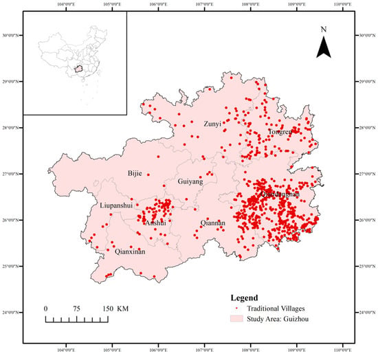
Figure 1.
Location and distribution of traditional villages in Guizhou province.
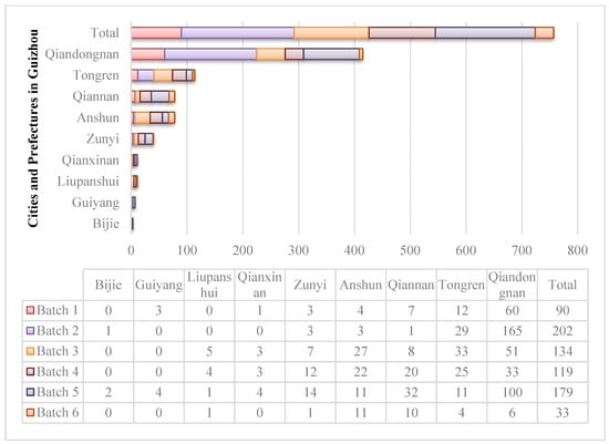
Figure 2.
Statistics on the number of 1–6 batch traditional villages in Guizhou’s cities and prefectures.
2.2. Data Sources
The data used in this study comprises the location information of traditional villages and related geographic and disaster factors. To ensure the scientific rigor and reproducibility of the research, all spatial data were obtained from authoritative public platforms (see Table 1) and processed in the ArcGIS 10.8 environment. Specifically, the location coordinates of 757 traditional villages were acquired to construct a digital model library of traditional villages in Guizhou Province. Raster and vector data, including Digital Elevation Model (DEM), administrative boundaries, rivers, and disaster records, were employed to derive the factors for this comprehensive evaluation system. A detailed description of the data is shown in Table 1.

Table 1.
Data details (all data were processed by the authors based on the sources listed in the table).
2.3. Research Methodologies
This study employed a systematic, multi-method approach to evaluate the spatial suitability of traditional villages in Guizhou’s karst mountains. The specific methodology steps are as follows (Figure 3):
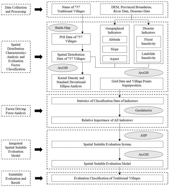
Figure 3.
Flowchart of research methodology.
- Data collection and processing: data for 757 villages and key spatial factors were collected and standardized within a GIS platform.
- Spatial distribution characteristics analysis: the spatial distribution pattern was analyzed using kernel density and standard deviational ellipse methods to identify clustering characteristics.
- Evaluation factor selection and classification: five evaluation factors (altitude, slope, aspect, flood, and landslide sensitivity) were selected and classified into different suitability levels.
- Factor driving force analysis: the Geodetector tool was applied to quantify each factor’s explanatory power and its interactive effects on village distribution.
- Integrated spatial suitability evaluation model: an integrated evaluation model was constructed by combining the objective weights from the Geodetector with the AHP to assign final factor weights.
- Suitability evaluation and result: a spatial suitability map was generated through weighted overlay analysis in GIS and classified into four distinct zones for result interpretation and policy formulation.
Through this integrated geographical-disaster factor approach, the research successfully established a spatial evaluation model, providing a scientific foundation for the sustainable management and conservation of traditional villages.
2.3.1. Data Collection and Processing
The information of 757 traditional villages in Guizhou Province was collected to construct the digital model library. During the data processing, the abstraction of villages to point features is standard practice for provincial-scale research. The inherent variability in the shape and size of their real-world boundaries does not compromise the validity of findings at this macroscopic level of analysis. Point-of-interest data for each village was obtained using the Baidu Maps application programming interface and imported into ArcGIS 10.8 to construct a digital model library of traditional villages in Guizhou Province. To ensure spatial consistency in ArcGIS 10.8, all data (including village location information, digital elevation model, provincial boundaries, river distribution, and disaster data) were constructed using the GCS_1984 geographic coordinate system and the UTM Zone 48 N projection coordinate system, with a spatial resolution of 30 m.
The author imported the collected data into ArcGIS 10.8 and configured it uniformly according to the above requirements. Based on DEM data (Figure 4), slope (Figure 5) and aspect (Figure 6) analysis tools are used to extract terrain parameters. Combined with pre-processed river data, rivers are treated as line features (Figure 7), and Euclidean distance analysis is used to assess flood susceptibility (Figure 8). Furthermore, based on data on geological hazards (slopes, collapses, and landslides, Figure 9), kernel density analysis is used to generate a landslide susceptibility distribution map (Figure 10). With this, the basic data for the comprehensive evaluation system of geological-disaster factors (altitude, slope, aspect, flood susceptibility, and landslide susceptibility) are readily available.
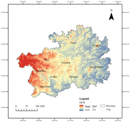
Figure 4.
Digital elevation model of Guizhou.
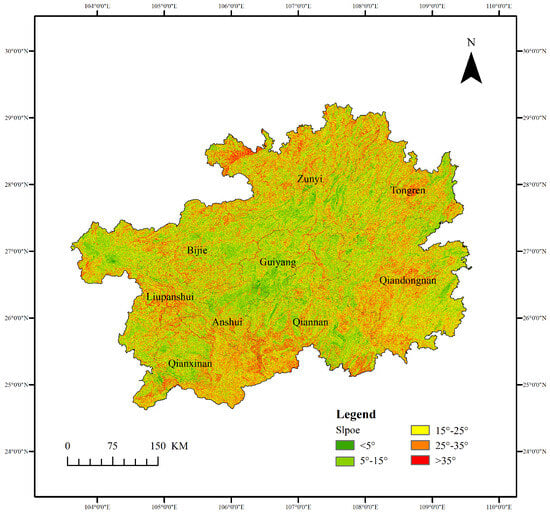
Figure 5.
Slope analysis of Guizhou.
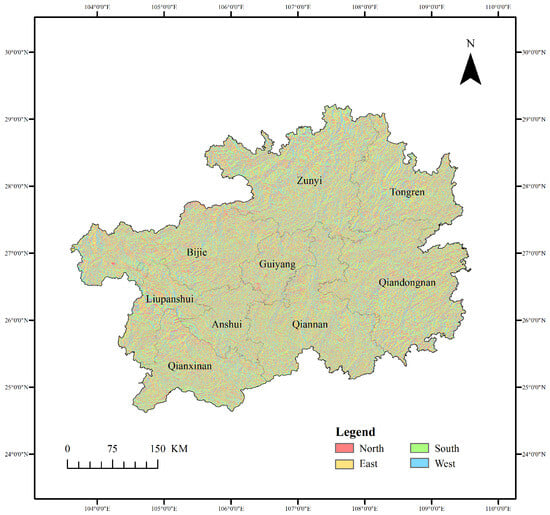
Figure 6.
Aspect analysis of Guizhou.
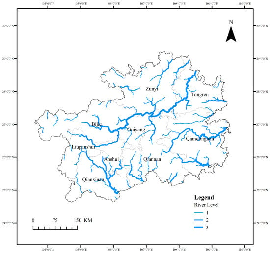
Figure 7.
Stream level of Guizhou. The numbers 1, 2, and 3 represent the stream order, with 1 being the smallest headwater streams and 3 being the largest, main river channels.
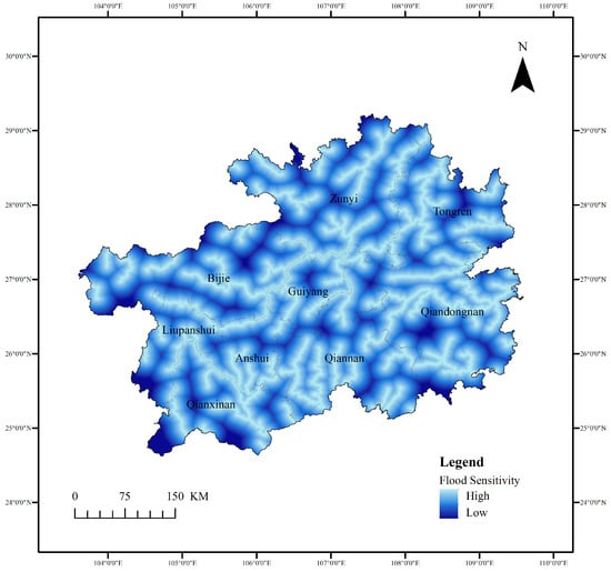
Figure 8.
Flood sensitivity of Guizhou.
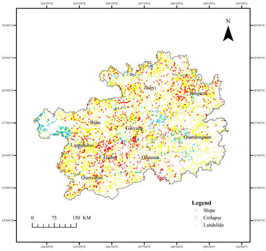
Figure 9.
Geographical disasters of Guizhou.
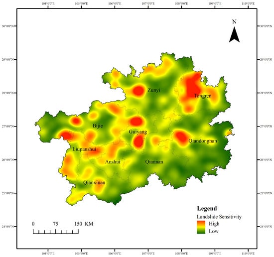
Figure 10.
Landslide sensitivity of Guizhou.
2.3.2. Spatial Distribution Characteristics Analysis
ArcGIS provides a variety of efficient and intuitive spatial analysis tools. Kernel density analysis is a non-parametric technique that uses kernel functions as weighting factors to approximate the probability density function of a random variable []. In the field of water resources management of village areas, kernel density analysis is used to identify spatial clustering patterns of key water-related phenomena []. This methodology can be used to gain a better understanding of spatial distribution from a macro perspective. It is particularly suited to this research on the spatial distribution of traditional villages of Guizhou. The Formula (1) is expressed as follows:
where k(·) is the Kernel Function, xi is a random village point in the research area, h is the search radius for the research scope, and n is the total number of the point features (in this study, n = 757). Based on the kernel density calculation results, it is easy to find the clustering of villages in various places. Where villages are densely populated, the kernel density values are high. Conversely, the values are low.
The standard deviational ellipse is a common form of spatial distribution directional analysis. This method can quantitatively explain the overall characteristics of the spatial distribution of features, such as centrality, directionality, and spatial typology []. It can be used in the research of traditional villages in Zhejiang Province to display the directional distribution and the center of gravity of the spatial distribution of traditional villages in Zhejiang Province []. The core of this algorithm consists of three steps. First, the center of the ellipse is determined by the mean center (Formula (2)). Second, the orientation of the ellipse is determined by rotating clockwise around the X-axis (major axis), with north direction at 0° (Formula (3)). Finally, the lengths of the X and Y axes are determined (Formula (4)).
where is the coordinate of the center of the standard deviation ellipse, is the location of each point feature, is the arithmetic mean center of the collection of features, and = 757 for the number of points. Meanwhile, is the orientation of the ellipse’s major axis, and are the deviation value of each point feature coordinate from the mean center (which means ). The position of the center of the ellipse represents the spatial center of the distribution of traditional villages in Guizhou. The first to sixth batches of data can be drawn into ellipses to visualize their development trends.
2.3.3. Evaluation Factor Selection and Classification
For a systematic assessment of traditional villages’ spatial suitability in Guizhou Province, this study selected the three most basic geographical factors of altitude (A), slope (B), and aspect (C), and combined them with the two disaster factors that are most likely to occur in mountainous areas: floods (D) and landslides (E). In contrast, researcher Jia’s existing system for Hebei Province uses nine factors across natural, socio-economic, and historical-cultural factors []. Although comprehensive and applicable to plain regions, Jia’s system cannot adapt to the ecological fragility of karst areas. However, the author Xu’s study in Fujian Province, which incorporates sensitivity factors, has shown stronger explanatory power []. Common classification methods for factors include the natural breaks method, the equal interval method, and others. Typically, different classification methods are tried based on the characteristics of the factors to obtain the optimal solution. After multiple trials, the natural breaks method is more suitable for altitude and landslide sensitivity in this research, while the equal interval method is more suitable for slope and flood sensitivity. Because the aspect data for traditional villages in Guizhou involves a wide range of directions, its classification method is referenced by the author Su’s research (dividing the aspect into eight zones and flat, and classified according to lighting conditions) []. All factors are classified using a uniform five-level system. The specific classification thresholds for each factor and their corresponding scores will be detailed in the subsequent results section.
2.3.4. Factor Driving Force Analysis
Spatial stratified heterogeneity is prevalent in various geographical phenomena []. The Geodetector is a spatial analysis tool for detecting spatial stratified heterogeneity and revealing the driving force behind it []. It is widely used for driving force analysis and factor analysis, like the author Xu statistically analyzed through Geodetectors to quantify the impact degree of environmental factors for assessment on the spatial distribution suitability []. The workflow of this method is divided into the following steps. First, according to the research objectives and literature review, the factors affecting the spatial distribution of traditional villages in Guizhou are selected, and the corresponding data resources are obtained. Secondly, all data are pre-processed and analyzed in ArcGIS 10.8, and different data grids with uniform pixel size are superimposed. Then, the overlaid raster values at each village are statistically extracted, and the Geodetector is used to quantify the degree of influence of each factor (Formulas (5) and (6)). Finally, the relative importance of each factor is evaluated in combination with the AHP method. The calculation formulas are as follows:
where the q value represents the explanatory power of a driving factor (X) on the spatial differentiation of a geographical phenomenon (Y), SSW is the within sum of squares, and SST is the total sum of squares. Additionally, represents the stratum (or factor) index, means the number of villages in the stratum, N denotes the total number of villages (757 in this study), represents the variance of Y values within stratum h, and is the total variance of Y values. The output of Geodetector is the factor detector result, the interaction detector result, the risk detector result, and the ecological detector result. The q value (in factor detector result) ranges from 0 to 1, and a higher value indicates a stronger correlation of the village spatial distribution.
2.3.5. Integrated Spatial Suitability Evaluation Model
The AHP method breaks down and subdivides decision-making elements, then analyzes them from both qualitative and quantitative perspectives. It is a systematic, efficient, and flexible decision-making approach []. This method generally relies on qualitative scores from experts, users, or stakeholders, with weights calculated using the square root method. The author Chen used geospatial and remote sensing data with the help of AHP to determine the suitability of tea cultivation in the study area []. However, this scoring method is subjective, requiring a sufficiently large amount of data or the participation of authoritative experts to enhance the persuasiveness of the results []. Therefore, before calculating weights through the AHP method, this study combined Geodetector to analyze the spatial heterogeneity of each factor and its interactions, providing an objective basis for weight calculation. The overall method steps are as follows: First, Geodetector is used to calculate the relative importance (q value) of each factor and the pairwise relationships between them (interaction detector). Second, based on the result of Geodetector, the AHP method is used to construct an evaluation matrix and calculate factor weights using the sum-product method. Additionally, a spatially suitable evaluation system for traditional villages in Guizhou is established by combining the characteristics of five factors (Formula (7)). Finally, ArcGIS 10.8 was used to perform a weighted overlay on the raster data of each factor to obtain the spatial assessment score of the village.
The formula is as follows:
where indexes the spatial suitable evaluation result of the i-th village, n denotes the total number of villages. Furthermore, has the same meaning as the Geodetector method, represents the weight for h-th factor, and is the score of h factor for village i. In accordance with the AHP weighting scheme, the weights are normalized such that their sum equals 1 ().
2.3.6. Suitability Evaluation and Result
Based on the evaluation scores calculated by the spatial suitability evaluation model, the scores were classified to form the final spatial assessment results. In previous studies, researcher Aymen AL-Taani divided land suitability evaluation into four categories for agricultural use in Jordan []. Similarly, author Guo classified the suitability evaluation of popular science tourism sites in Guangzhou University town into three levels plus non-tourism areas []. Meanwhile, another study on environmental suitability evaluation for human settlements in rural residential areas of Hengshui also categorized the results into four classes []. Based on these precedents, this research uses the natural breaks method to classify the spatial assessment results into four types of areas: highly suitable, suitable, moderately suitable, and unsuitable. The specific classification thresholds for each type and their corresponding areas will be detailed in the subsequent results section.
3. Research Results
3.1. Spatial Distribution Characteristics
3.1.1. Kernel Density Analysis
ArcGIS kernel density analysis is used to analyze the spatial distribution characteristics of Guizhou’s traditional villages. Based on the distribution density of villages in the karst mountainous areas of Guizhou, after multiple parameter adjustments, we finally chose h = 30 km as the search radius. This specific value was selected to accurately reflect the natural, large-scale clustering of villages dictated by the rugged karst terrain, while avoiding a map that was either too fragmented (under-smoothed) or too generalized (over-smoothed). The results show an overall dual-core clustering pattern, with villages in each batch exhibiting single-core or multi-core clustering, particularly in southeastern Guizhou (Figure 11). The results of the second and fifth batches show a single-core clustering pattern in Qiandongnan, while villages in other regions are more scattered. Statistical data supports this finding: Qiandongnan boasts 415 national-level traditional villages, accounting for 54.82% of the province, exceeding half the total. This high number of traditional villages may be closely related to the region’s rich ethnic cultural resources and its ongoing efforts to preserve them. Another core of the overall distribution is located in Anshun. From the results of the kernel density analysis of the batches, it can be found that in the third, fourth, and sixth batches, Anshun is the second core area. At the same time, it is worth noting that in the first batch, the second core area is Tongren. However, in the overall distribution results, the distribution concentration of Tongren is relatively weak. Therefore, the kernel density analysis results are superimposed and compared with the village point elements (Figure 1). Through comparison, it can be intuitively found that although the number of traditional villages in Tongren (114) is more than that in Anshun (78), the density of village distribution in Tongren is significantly lower than that in Anshun.
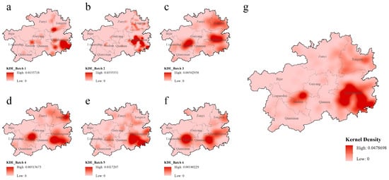
Figure 11.
Kernel density analysis of traditional villages by batch in Guizhou. (a) Analysis result of 1st batch. (b) Analysis result of 2nd batch. (c): Analysis result of 3rd batch. (d) Analysis result of 4th batch. (e) Analysis result of 5th batch. (f) Analysis result of sixth batch. (g) Analysis result of all batches.
3.1.2. Standard Deviational Ellipse
Standard deviational ellipse analysis helps to analyze the directional characteristics and trends of the spatial distribution of traditional villages. The results (Figure 12) show that the center of the overall standard deviational ellipse for all study sites is located in the southeast. This result corroborates the kernel density analysis. While the spatial locations of the standard deviational ellipses for each batch vary, they are primarily concentrated in the southeastern part of Guizhou Province. The core of the overall distribution is located in central Qiandongnan, with a northeast-southwest distribution. The major axis of the ellipse is longer than the minor axis, indicating that the village distribution extends northeast-southwest and exhibits a high degree of dispersion (Table 2). The core centers of each batch are primarily located in western Qiandongnan or near the junction of Qiandongnan and Qiannan, with large east–west differences and smaller north–south differences. The core center of the sixth batch is significantly more westward than that of the other batches. Therefore, further analysis by superimposing village point elements reveals that the sixth batch contains far fewer villages than the previous five batches, and is primarily located in Qiannan and Anshun. This characteristic may be related to the stage-by-stage nature of the traditional village selection process. As the selection process enters the middle and later stages, the number of villages meeting the criteria decreases, and the spatial distribution becomes more dispersed. Meanwhile, the high-quality villages in the east have been basically selected, and the focus has moved to the potential villages in the west in the last stage. Comparing the ellipse shapes of these six batches reveals that the second batch’s ellipse is the smallest, with a distribution direction close to north–south. Combined with the village data, this batch contains the most selected villages, with the majority located in southeastern Guizhou, indicating the most concentrated village distribution. The standard deviation ellipses for the third and fourth batches are similar in size but significantly larger than those for the other batches. Their distribution direction is northeast-southwest, with the major axis significantly larger than the minor axis. This suggests that the villages in these two batches have a wider spatial distribution, significant directionality, and a higher degree of dispersion.
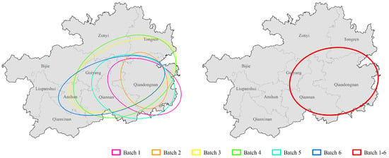
Figure 12.
Standard deviational ellipse of traditional villages by batch in Guizhou.

Table 2.
Standard deviational ellipse parameters of the traditional village by batch in Guizhou.
3.2. Spatial Suitability Evaluation Model Implementation
3.2.1. Drivers’ Classification
Combining geographical and disaster factors can provide a deeper understanding of the impact of geography and geology on the spatial distribution of traditional villages in Guizhou. These factors, including altitude (A, Figure 3), slope (B, Figure 4), aspect (C, Figure 5), flood sensitivity (D, Figure 7), and landslide sensitivity (E, Figure 9), should be classified into levels 1–5. (Figure 13) Research revealed that due to Guizhou’s unique geographical environment, some villages only gained access to roads a few years ago. Accordingly, the altitude of Guizhou’s mountainous areas, to a certain extent, represents the accessibility of villages. Generally, villages with higher altitudes have less convenient transportation, and therefore receive lower levels in the classification. Therefore, altitude data were classified into five categories using the natural breaks method: level 5 (<499 m), level 4 (499 m–694 m), level 3 (694 m–878 m), level 2 (878 m–1132 m), and level 1 (1132 m–1755 m). However, data show that traditional villages are not the most numerous in low-altitude areas. Rather, they are concentrated in the medium-altitude range. Hence, other factors need to be considered comprehensively. The gentleness of the slope determines the difficulty for villagers in daily travel and construction, so gentle slopes should be assigned higher classifications. Since then, the slope data were classified into five levels using the equal interval method: level 5 (<10°), level 4 (10–15°), level 3 (15–20°), level 2 (20–25°), and level 1 (25–44°). The data clearly show that more traditional villages are concentrated in areas with lower slopes. The aspect classification is primarily based on the duration of sunlight exposure. First, the overall slope aspect was divided into nine ranges: north (0–22.5°, 337.5–360°), northeast (22.5–67.5°), east (67.5–112.5°), southeast (112.5–157.5°), south (157.5–202.5°), southwest (202.5–247.5°), west (247.5–292.5°), northwest (292.5–337.5°), and flat. Then, the classification was assigned based on the lighting conditions from optimal (level 5) to poorest (level 1), as follows: south (level 5), southeast and southwest (level 4), east, west, and flat (level 3), northeast and northwest (level 2), and north (level 1). Based on the results of the sensitivity analysis, the higher the susceptibility of a village’s location, the greater the likelihood of the disaster occurring. Therefore, when assigning classifications to these partitions, higher sensitivity corresponds to lower levels. Hence, the two sensitivity factors should be classified into five levels as follows: extremely high sensitivity (level 5), high sensitivity (level 4), medium sensitivity (level 3), low sensitivity (level 2), and very low sensitivity (level 1).
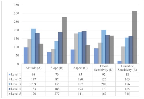
Figure 13.
Statistics of classification data of indicators.
3.2.2. Weight Assignment
Geodetector’s Factor Detector quantifies the explanatory power of individual factors. A higher q value indicates a stronger correlation between the factor and the dependent variable. The Interaction Detector identifies interactions between factors, including reinforcing, independent, or weakening effects []. This study imported the classification of five factors—altitude, slope, aspect, flood sensitivity, and landslide sensitivity—for 757 villages into Geodetector. Using the kernel density of traditional villages as the dependent variable (Y), the individual influence of each factor is calculated using Formulas (5) and (6). The results (Table 3) clearly show that the individual influence of each factor varies significantly, ranking from largest to smallest as A > D > E > B > C. Altitude (A) has the greatest influence, followed by flood susceptibility (D), landslide susceptibility (E), and slope (B). Aspect (C) has the weakest influence. Subsequently, based on the calculated results, the AHP method is combined to assign corresponding weights to each influencing factor. Meanwhile, the final weights of factors should obey A > D > E > B > C.

Table 3.
q value of the single-factor detection.
The results of the interaction detector (Table 4) also provide references in judging the importance of factors in AHP. It can be found that all the interaction results among the five indicators are nonlinear enhancements. The highest one is between altitude (A) and landslide susceptibility (E), where q = 0.151300 is much higher than the q value of themselves. High-altitude areas in karst mountainous areas are often accompanied by steep slopes, making them prone to landslides. The interaction between the two significantly enhances the explanatory power of village distribution, indicating that village locations avoid both high altitudes and areas highly susceptible to landslides, confirming the site selection logic of “seeking benefits and avoiding harm”.

Table 4.
Interaction relationships between factors.
3.2.3. Spatial Suitable Evaluation System
The AHP method combines qualitative and quantitative methods to calculate decision weights. Combined with Geodetector, it can mitigate the influence of subjective judgment in AHP to a certain extent. Based on the relative importance (q value) of each factor, the judgment matrix (Table 5, CR = 0.055 < 0.1, the matrix is valid) was established by the 1–9 scaling method in AHP, and the corresponding weights were calculated using the sum-product method (Table 6).

Table 5.
Judgment matrix through AHP (SPSSPRO data processing platform).

Table 6.
Spatially suitable evaluation system of Guizhou traditional villages.
The final weights show that in the spatial distribution of traditional villages in Guizhou, altitude has a weight of 43.59%, flood susceptibility has a weight of 22.29%, and landslide susceptibility has a weight of 17.38%. Based on the grading of each factor, each level within the factor is assigned a corresponding evaluation score. This study uses a linear assignment method, assigning 9 to level 5, 7 to level 4, 5 to level 3, 3 to level 2, and 1 to level 1. This score only represents the relative strengths and weaknesses of each level within the same factor. Additional details are provided in Table 6.
3.3. Spatial Suitability Evaluation Result
3.3.1. Evaluation Map Generation
Based on the weights assigned to each factor in the spatial suitability evaluation system, raster layers representing the five factors (Figure 3, Figure 4, Figure 5, Figure 7 and Figure 9) were reclassified (scored) and weighted overlaid (weight processing) in ArcGIS. The resulting overlay (Figure 14) represents the spatial suitability evaluation results for Guizhou Province, with scores ranging from 1 to 9. It can be seen that the eastern region of Guizhou Province received higher scores, while the western part of Guizhou (Yunnan-Guizhou Plateau and its surrounding areas) received lower scores.
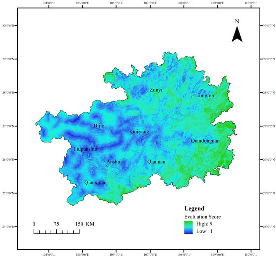
Figure 14.
Spatially suitable evaluation results of Guizhou Province.
3.3.2. Threshold Determination
To more intuitively and effectively analyze the spatial suitability evaluation results of Guizhou’s traditional villages, the raster data generated by the weighted overlay was classified using the natural breaks method, categorizing the entire province into four categories: highly suitable, suitable, moderately suitable, and unsuitable (Table 7).

Table 7.
Range and classification of spatial suitable evaluation results of Guizhou Province.
3.3.3. Zoning Results and Analysis
Based on the range divisions in Table 7, the spatial suitability evaluation results for Guizhou were reclassified to obtain the classification results (Figure 15). The results show that the spatially suitable evaluation trends for Guizhou Province are somewhat consistent with the topographic trends.
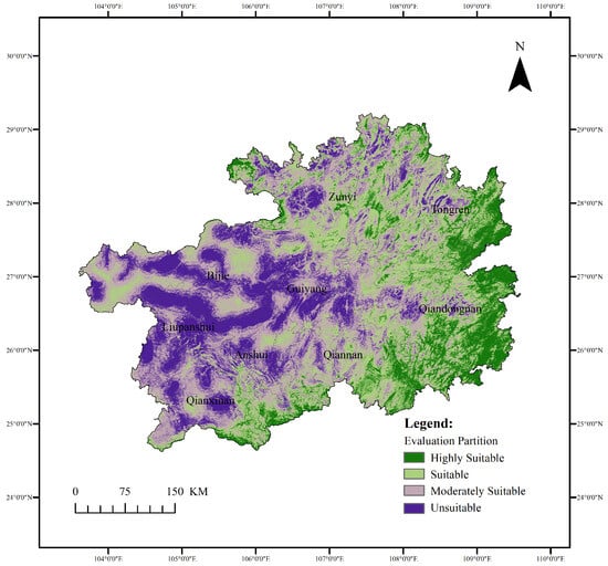
Figure 15.
Classification of spatially suitable evaluation results of Guizhou province.
The spatial evaluation of the southwestern part (Yunnan-Guizhou Plateau) is primarily moderately suitable and unsuitable, which is related to the region’s extensive karst topography, low transportation accessibility, and high ecological fragility. The eastern region, with its lower altitude, is primarily rated highly suitable and suitable. In addition to its advantages in multi-ethnic cultural resources, this region also boasts superior ecological protection and transportation accessibility to other regions. In the northern region (Zunyi and Tongren), although some areas are at higher altitudes, the distribution of the four types is more balanced than in other regions, reflecting the region’s spatial complexity and transitional nature.
From the specific data statistics (Table 8), it can be found that 13.82% of the total area of Guizhou Province is a highly suitable area, which contains 312 traditional villages, accounting for 41.22% of the total number of traditional villages. By overlaying the analysis with the village point elements, it can be observed that the traditional villages in the highly suitable area are mainly concentrated in the low-altitude areas of Qiandongnan and its vicinity. Although the area of the suitable is less than that of the moderately suitable (27.46% and 36.44%, respectively), the number of villages contained in these two areas shows the opposite. There are 254 traditional villages in the suitable area, which is around double the number of traditional villages in the moderately suitable area (133). The unsuitable area accounts for 22.28% of the province, which is higher than the proportion of the highly suitable area, but the number of traditional villages is relatively small (58, accounting for 7.66%). The above results show that among the 757 traditional villages in this study, 92.34% are distributed in areas with suitable spatial assessment results (including highly suitable, suitable, and moderately suitable).

Table 8.
Classification data statistics by batches of spatially suitable evaluation results of Guizhou Province.
4. Discussion
4.1. Interpretation of Key Findings
The study of the spatial distribution characteristics of traditional villages in Guizhou reveals a dual-core clustering pattern (Qiandongnan and Anshun). This analysis differs from the patterns found in other provinces, like Yunnan (exhibits a spatial pattern of “one belt–three clusters–multiple points”) []. In the study of Yunnan, Guangxi, and Guizhou rocky desertification areas, they find the same result that the traditional villages predominantly exhibit an agglomerative distribution pattern, with pronounced concentrations in southeast Guizhou and secondary concentrations in Anshun and Guilin []. This dual-core model holds significant implications for administrative governance. It suggests that conservation efforts and resource allocation can be strategically focused on these two core areas, potentially leading to more efficient and impactful outcomes than a dispersed approach. This spatial model aligns with the hierarchical understanding of cultural landscapes. As Prof. Heping Li categorizes, traditional villages constitute a core component of the settlement landscape []. The dual-core clustering pattern in Guizhou can thus be interpreted as the manifestation of a distinct regional landscape, where the settlement landscapes are not randomly distributed but are organized around these two focal points. Identifying this regional pattern is the first step in developing a holistic conservation and management approach for the larger cultural landscape. Comparing this model to other locations underscores its contextual specificity. Furthermore, studies on the spatial distribution of traditional villages on the Loess Plateau have also identified a dual-core layout in Shanxi Province, characterized by one core formed by the cultural and commercial hub and another driven by the strategic military and trade []. This recurrence of the dual-core pattern in different geographical contexts suggests that while the specific natural and historical drivers may differ, the phenomenon of settlement agglomeration into two primary centers is a recognizable spatial model in China’s traditional human geography. The reasons for this pattern are as follows: First, geographic factors underlie village distribution. Qiandongnan, situated in the transition zone between the Yunnan-Guizhou Plateau and the Xiangxi hills, enjoys a moderate altitude (mostly between 400 and 1000 m), which makes it suitable for population concentration. Anshun boasts a relatively high altitude (mostly above 1000 m) with typical karst landforms. Its development benefited from the topographical advantages of a small basin between mountain ranges. Second, Qiandongnan is home to a diverse range of ethnic minorities. The strong sense of cultural identity and belonging to the region has fueled the formation of this core cluster of traditional villages. Finally, based on the migration routes of Guizhou’s indigenous ethnic groups, it is revealed that most transportation in Qiandongnan was carried out via the Qingshui River, with Anshun serving as a key stop point on the Yunnan-Guizhou Ancient Road. Therefore, the dual-core aggregation model of traditional villages in Guizhou is the product of the superposition and coupling of the suitability of natural geography, the centripetal force of national culture, and the orientation of historical transportation. At the same time, it also confirms the existence of a human-land relationship adaptation mechanism of “seeking benefits and avoiding harm” in karst mountainous areas.
Results from the Geodetector’s factor detector show that among the five factors, altitude (A, q = 0.034685) and flood susceptibility (D, q = 0.026732) are the most influential. Meanwhile, these two factors also have a relatively high influence, compared to the other three factors, in studies of ethnic minority villages in Fujian []. Agricultural productivity and climate conditions are directly correlated with altitude. Climate conditions in higher altitudes fail to support agricultural productivity, while flood risk is higher in lower altitudes. Combining flood susceptibility analysis with the spatial distribution of villages reveals that areas with high village concentrations have less overlap with areas of high flood sensitivity. Interaction detector analysis reveals that the interactions between the five factors exhibit nonlinear enhancement, with the highest interaction force (q = 0.151300) between altitude (A) and landslide susceptibility (E). This further confirms the rationale for analyzing geographic factors and hazard factors in the study of the spatial distribution of traditional villages in Guizhou. Although altitude had the highest q value of the five factors, overall, the q values in this study were relatively low. After many experiments on factor classification, including using the nature breaks method and the equal interval method, the factor classification method presented in the current study is the optimal result. This finding has been corroborated by other studies [,]. Therefore, future research should include more influencing factors for a more comprehensive assessment.
4.2. Model Innovation and Limitations
Influenced by the karst mountainous terrain, many areas of Guizhou are plagued by high rock erosion rates, scarce soil, and soil erosion. Consequently, the steeper the slope, the greater the possibility of disasters such as landslides. So, village site selection in Guizhou’s mountainous areas depends not only on basic geographical factors such as altitude, slope, and aspect, but also on historical disaster experience. Therefore, the study of the spatial distribution of traditional villages in Guizhou requires quantitative analysis and interpretation of historical disaster data. For this reason, combining Geodetector with AHP objectively interprets the combined explanatory power of geographic and disaster factors on village distribution (measured by q value) while ensuring the rationality of factor weighting in the AHP method. The other researchers successfully employed Geodetector to identify and quantify the driving factors of land use change and used AHP to determine the relative weights of these factors for an integrated assessment to establish an evaluation model for the suitability of human settlements []. While their study focused on general human settlement suitability, our research specifically applies this integrated approach to traditional villages in Guizhou’s disaster-prone karst terrain, thereby extending the methodology to a more specialized and historically conditioned context. Furthermore, Geodetector not only assesses the influence of individual factors but also analyzes the interactions between them, enabling a deeper analysis of the relationship between the distribution of traditional villages and various factors, thereby enhancing the explanatory power and adaptability of spatial assessment models. This is difficult to achieve with a single method. Critically, our findings quantitatively validate the rationality of the spatial distribution of traditional villages, demonstrating that their locations are the result of a long-term adaptive selection process to complex geographical and disaster-related conditions.
Although the Guizhou traditional village database and spatial assessment model established in this study achieved promising results, certain limitations remain. First, the study did not fully consider the impact of temporal dynamics. The national list of traditional villages has been published since 2012, with the sixth batch of lists finally released in 2023. However, compared with existing research [,], this paper has not systematically analyzed the differences in the policy-driven factors among different batches of selected villages, nor has it incorporated the time dimension as an explanatory variable into the Geodetector model, which limits the in-depth interpretation of the influence mechanism of the selection policy. When the fourth batch of traditional villages was announced, some villages in the first batch had been listed as demonstration villages, which would greatly increase the attention of relevant personnel in around area to village protection. That is why some counties in Qiandongnan have more listed traditional villages. Second, this study focused on 757 national traditional villages and did not include other villages with development potential, which may limit the universality of the evaluation results. In addition to the traditional village list, there is also data on ethnic minority villages, provincial and municipal villages, etc. Although existing research mostly focuses on single-level village analysis, comparing the distribution patterns of villages at different levels will improve the universality of the evaluation model []. Furthermore, this study primarily focused on the interaction between geographical factors and disaster factors and did not consider other types of factors (social factors [], production factors [], and so on). This may be the reason why the results in the Geodetectors of this research are commonly low. In the future, transportation accessibility, economic level, cultural value, etc., can be incorporated into the evaluation system to construct a four-dimensional model of “geography-disaster-society-economy”.
4.3. Policy Implications
The spatial suitability evaluation, integrated with a critical analysis of geological-disaster factors, reveals that disaster risk is a fundamental determinant for conservation planning in Guizhou’s karst environments. Policy responses must, therefore, be differentiated based not only on suitability levels but also on the distinct disaster susceptibility patterns across regions. A comparative analysis of these patterns shows that a one-size-fits-all approach is ineffective. Instead, strategies must be tailored to the specific interplay between suitability and local hazard exposure []. Building a sustainable development system for traditional villages in Guizhou necessitates embedding disaster adaptation and mitigation as core components of all spatial and developmental strategies.
In highly suitable areas (most of Qiandongnan), where disaster risks are relatively lower, conservation efforts should not only focus on cultural and tourism development but also incorporate proactive hazard preparedness. The author Beltramo built a territorial heritage framework for thematic tourist trails; the analysis highlighted how the integrated enhancement of tangible and intangible resources, combined with the active involvement of local communities, can be a strategic lever for the sustainable development of low-density tourism areas []. While strengthening physical and cultural connectivity between villages—for instance, through themed tour routes and service networks—it is essential to simultaneously reinforce slope stabilization and water management systems. These measures will improve resilience to rainfall-induced geological hazards and safeguard both villagers and cultural assets.
By contrast, in the western plateau and mountainous regions of Guizhou (less suitable for evaluation results), disaster risk proves to be the overriding constraint. Here, conservation and revitalization cannot proceed without prior and continuous hazard mitigation. In the research of Mujahidul Islam, they discussed a success story, elucidating climate risk management techniques and their roles in floods, cyclones, and droughts []. Meanwhile, they have profound implications across social, environmental, and financial sectors, which strengthen disaster risk reduction initiatives, influence policy and technical advancements, and support local, national, and global resilience. These kinds of methods might also be useful in Guizhou. Since that, spatial planning must prioritize the installation and maintenance of disaster prevention infrastructure, the establishment of scientifically informed early warning systems, and the design of efficient evacuation protocols. Development strategies should shift from active revitalization to defensive adaptation, minimizing exposure to geological threats while enhancing the capacity for rapid post-disaster recovery.
For the widely distributed suitable and moderately suitable areas (concentrated in northern Guizhou and transition zones), the development policy must reflect their fragmented topography and variable hazard exposure. While leveraging local cultural initiatives—such as the Village Football Super League—can stimulate regional vitality, it is equally critical to address location-specific vulnerabilities. In Yan’s study, they discussed the success factors of the Village Football Super League in Guizhou and how to resolve the relationship between cultural development and ecological fragility []. While the success of the football league is no coincidence, it has provided more feasible solutions for the development of traditional villages in Guizhou. Moderately suitable areas, in particular, require targeted investments in improving disaster resilience, infrastructure upgrading, and community participation mechanisms to reduce their susceptibility to environmental disturbances and narrow the gap with more suitable regions.
Ultimately, this hazard-aware suitability assessment underscores the need to transcend conventional development classifications. Only by systematically internalizing disaster risk into spatial planning and policy design can traditional villages in karst regions achieve sustainable and climate-resilient conservation.
5. Conclusions
This study verified that the Geodetector-AHP integrated model can effectively evaluate the spatial suitability of 757 traditional villages in Guizhou Province. The evaluation yields the following key results:
- The spatial distribution of traditional villages in Guizhou Province exhibits a dual-core clustering pattern (Qiandongnan and Anshun), with the largest number of villages and denser distribution in Qiandongnan. The overall distribution trend is centered in Qiandongnan and extends northeast-southwest. This pattern is highly consistent with Guizhou’s karst topography. Kernel density analysis and standard deviational ellipse analysis reveal that the distribution of traditional villages in Guizhou is not only constrained by geographic environment but also influenced by ethnic culture and historical development.
- This study focused on constructing a spatially suitable evaluation model for traditional villages in Guizhou based on geographical and hazard factors. Altitude (A), slope (B), and aspect (C) were selected as the basic geographical factors, and flood susceptibility (D) and landslide susceptibility (E) were selected as hazard factors. Geodetector analysis results showed that the influence of individual factors ranked as A > D > E > B > C, with altitude (q = 0.034685), flood susceptibility (q = 0.026732), and landslide susceptibility (q = 0.025567) having the strongest explanatory power. Interaction detector results showed that the interaction between altitude and landslide susceptibility was the highest (q = 0.151300), followed by the interaction between flood susceptibility and landslide susceptibility (q = 0.135186), both of which significantly outweighed the interaction effects of other factors.
- Combining the influence factors constructed using Geodetector with the AHP method, a spatial assessment system for traditional villages in Guizhou was established. The assessment results divided the province into four zones: highly suitable, suitable, moderately suitable, and unsuitable. Highly suitable areas account for 13.82% of the area and include 41.22% of Guizhou’s traditional villages. These areas are primarily located in Qiandongnan and are characterized by low altitudes and low risk. Unsuitable areas account for 22.28% of the area but only include 7.66% of the villages. These areas are primarily located in the high-altitude areas of the Yunnan-Guizhou Plateau. Suitable and moderately suitable areas are more sparsely distributed, differing from each other in subtle differences in comprehensive assessment. Suitable areas have higher overall scores and generally demonstrate better geographical conditions or disaster resilience. Moderately suitable areas, on the other hand, have shortcomings in one or more of these conditions.
This research also successfully validated the applicability and effectiveness of this integrated evaluation model in karst landforms, integrating both geographic and hazard dimensions. Meanwhile, it also provides empirical support for the theory of human-land adaptability. This evaluation model is applicable not only to traditional villages but also provides a universal research framework for heritage conservation areas, tourist areas, and cultural landscapes in Guizhou. As the core output of this study, the spatial assessment of traditional villages in Guizhou can inform designated conservation plans and spatial remediation at the provincial, municipal, and county levels, laying a foundation for future development and construction. Furthermore, the batch-wise spatial evolution analysis offers critical insights for policymaking. For instance, the comparison between Tongren and Anshun highlights how karst terrain constrains settlement expansion. This type of batch analysis helps decision-makers recognize that village distribution is not solely a function of quantity but of terrain-carrying capacity, aiding in more nuanced regional planning. Similarly, the westward shift in the core center in the sixth batch of villages underscores the impact of phased selection criteria and diminishing suitable sites in later stages. For experts and planners, this pattern signals the need to shift conservation strategies from centralized protection to adaptive management for more scattered areas, as fewer villages qualify over time.
This research concludes that the spatial distribution and suitability of traditional villages in Guizhou are profoundly shaped by the karst landform, which acts as a dominant environmental filter. By quantitatively verifying human-land adaptability in karst regions, this study establishes that altitude interacting with landslide and flood susceptibility is the primary controlling factor. This finding represents a distinctive signature of the human-land system within this unique geological context. For future research, social and economic factors can be added to the existing evaluation system to establish a multidimensional spatial assessment system. Furthermore, diversifying the research subjects should be a key focus in the next phase of research. For example, by integrating lists of villages of different levels and focuses for comparative research, a more informed approach to selecting research subjects can be achieved. Additionally, actively learning and exploring new research methods will help improve the accuracy and precision of the assessment model, like machine learning and media data mining.
Author Contributions
Methodology, Y.L.; software, Y.L.; validation, P.V.G. and Y.Z.; analysis, Y.L.; investigation, Y.L. and Y.Z.; resources, Y.L.; data curation, Y.Z.; writing—original draft preparation, Y.L.; writing—review and editing, Y.Z.; visualization, Y.L.; project administration, Y.L.; funding acquisition, P.V.G. All authors have read and agreed to the published version of the manuscript.
Funding
This research is funded by Zhejiang University: 876-211 Class Project, funding project code: 113000*1942221R1/007, and the scientific research start-up fund of Qiushi Distinguished Professor of Zhejiang University School of Construction Engineering. This research was also funded by the China Scholarship Council, funding project code: 202106250001, and the Tianjin Graduate Research Innovation Project, funding project code: 2021YJSB149.
Data Availability Statement
The raw data supporting the conclusions of this article will be made available by the authors on request.
Acknowledgments
Thanks to the Ministry of Housing and Urban-Rural Development of Guizhou Province and the Taijiang County Government for their support and assistance during the field survey in this research.
Conflicts of Interest
The authors declare no conflicts of interest. The funders had no role in the design of the study; in the collection, analyses, or interpretation of data; in the writing of the manuscript; or in the decision to publish the results.
References
- Tianjin University Feng Jicai Institute of Literature and Art. Available online: https://fjcxy.tju.edu.cn/teaching.html (accessed on 20 August 2025).
- Liu, Y.D.; Zhang, Y.P.; Xu, X. Visual Analysis of Research on Traditional Miao Villages in Guizhou Based on Citespace. Archit. Creat. 2022, 05, 178–183. [Google Scholar]
- The State Council the People’s Republic of China. Available online: https://www.gov.cn/xinwen/2023-03/21/content_5747704.htm (accessed on 20 August 2025).
- Nie, X.; Wang, Q.; Wu, J.; Wang, H.; Chen, Z.; He, J. Effectively enhancing perceptions of cultural ecosystem services: A case study of a karst cultural ecosystem. J. Environ. Manag. 2022, 315, 115189. [Google Scholar] [CrossRef]
- World Heritage Glossary. Available online: https://whc.unesco.org/en/glossary/225 (accessed on 28 October 2025).
- Birnbaum, C.A. The Secretary of the Interior’s Standards for the Treatment of Historic Properties: With Guidelines for the Treatment of Cultural Landscapes; National Park Service Division of Publications: Washington, DC, USA, 1996. [Google Scholar]
- Zhang, Y.W.; Shu, Y.; Li, J. Exploring the Protection Paradigm of Traditional Village Cultural Landscapes Based on Isomorphic Characteristic Analysis. South. Archit. 2025, 9, 93–103. [Google Scholar]
- Giordano, S. Agrarian landscapes: From marginal areas to cultural landscapes—Paths to sustainable tourism in small villages—The case of Vico Del Gargano in the club of the Borghi più belli d’Italia. Qual. Quant. 2020, 54, 1725. [Google Scholar] [CrossRef]
- Ducros, H. The New Rural in Les Plus Beaux Villages de France: Heritage Preservation, Promotion and Valorization in the Post-agricultural Village. Ph.D. Dissertation, University of North Carolina, Chapel Hill, NC, USA, 2014. [Google Scholar]
- Di Fazio, S.; Modica, G. Historic rural landscapes: Sustainable planning strategies and action criteria. The Italian experience in the global and European context. Sustainability 2018, 10, 3834. [Google Scholar] [CrossRef]
- Sezer, E. Historical Assets Analysis in Heritage Sites for Cultural Landscape Management. Case Studies of Aristocratic Estates from Italy, France and Spain. Ph.D. Dissertation, Politecnico di Torino, Torino, Italy, 2020. [Google Scholar]
- Radzuan, I.S.M.; Fukami, N.; Yahaya, A. Cultural heritage, incentives system and the sustainable community: Lessons from Ogimachi Village, Japan. Geografia 2014, 10, 130–146. [Google Scholar]
- Chiang, Y.C.; Weng, P.Y.; Sato, N. The Preservation of Important Rural Japanese Cultural Landscapes—Considering the Warabino Paddy Field as an Example. J. Fac. Agric. Kyushu Univ. 2013, 58, 209–218. [Google Scholar] [CrossRef]
- Karle, S.; Carman, R. Digital Cultural Heritage and Rural Landscapes: Preserving the Histories of Landscape Conservation in the United States. Built Herit. 2020, 4, 5. [Google Scholar] [CrossRef]
- Robinson, E.B. Cultural Landscapes and Traditional Cultural Properties: A Study in Designation and Protection. Ph.D. Dissertation, Rutgers University, New Brunswick, NJ, USA, 2017. [Google Scholar]
- Deng, S.Q. Investigation Report on Gaobaibang Miao in Huishui, Guizhou. Guizhou Ethn. Stud. 1999, 1, 88–96. [Google Scholar]
- Smith, J.C. The Hmong, 1987–1995: A Selected and Annotated Bibliography; DIANE Publishing Company: Collingdale, PA, USA, 1998. [Google Scholar]
- Xu, K.; Chai, X.; Jiang, R.; Chen, Y. Quantitative Comparison of Space Syntax in Regional Characteristics of Rural Architecture: A Study of Traditional Rural Houses in Jinhua and Quzhou, China. Buildings 2023, 13, 1507. [Google Scholar] [CrossRef]
- Jia, S.; Isa, M.H.B.M.; Aziz, Z.B.A. Spatial Characteristics of Defensive Traditional Architecture in Multiethnic Village of Guangxi: Case Studies of Mozhuang Village and Guxietun Village. Front. Archit. Res. 2023, 12, 683–699. [Google Scholar] [CrossRef]
- Gao, J.; Wu, B. Revitalizing Traditional Villages Through Rural Tourism: A Case Study of Yuanjia Village, Shaanxi Province, China. Tour. Manag. 2017, 63, 223–233. [Google Scholar] [CrossRef]
- Li, Y.; Fan, P.; Liu, Y. What Makes Better Village Development in Traditional Agricultural Areas of China? Evidence from Long-Term Observation of Typical Villages. Habitat Int. 2019, 83, 111–124. [Google Scholar] [CrossRef]
- Li, X.; Zhang, F.; Hui, E.C.M.; Lang, W. Collaborative Workshop and Community Participation: A New Approach to Urban Regeneration in China. Cities 2020, 102, 102743. [Google Scholar] [CrossRef]
- Luo, Y.; Qi, L. Construction and Practice of a Conservation Plan Implementation Evaluation System for Historic Villages. J. Asian Archit. Build. Eng. 2019, 18, 351–361. [Google Scholar] [CrossRef]
- Zhang, H.; Li, B.H.; Dou, Y.D. The Characteristics and Mechanisms of the Evolution of Traditional Village Landscape Restoration Under the Power of Digital Technology: A Case Study of Zhangguying Village in Yueyang City, Hunan Province. J. Nat. Resour. 2024, 39, 1797–1814. [Google Scholar] [CrossRef]
- Yu, L.; Xie, D.; Xu, X. Environmental suitability evaluation for human settlements of rural residential areas in Hengshui, Hebei Province. Land 2022, 11, 2112. [Google Scholar] [CrossRef]
- Yang, G.; Wu, L.; Xie, L.; Liu, Z.; Li, Z. Study on the Distribution Characteristics and Influencing Factors of Traditional Villages in the Yunnan, Guangxi, and Guizhou Rocky Desertification Area. Sustainability 2023, 15, 14902. [Google Scholar] [CrossRef]
- Ford, D.; Williams, P.D. Karst Hydrogeology and Geomorphology; John Wiley & Sons: Hoboken, NJ, USA, 2007; pp. 25–31. [Google Scholar]
- China Population Census Yearbook 2020. Available online: https://www.stats.gov.cn/sj/pcsj/rkpc/7rp/indexch.htm (accessed on 25 August 2025).
- Traditional Chinese Villages Digital Museum. Available online: http://www.dmctv.cn (accessed on 15 December 2022).
- Geospatial Data Cloud. Available online: http://www.gscloud.cn (accessed on 28 June 2025).
- National Catalogue Service for Geographic Information. Available online: http://www.webmap.cn (accessed on 28 June 2025).
- National Earth System Science Data Centre. Available online: http://www.geodata.cn (accessed on 10 July 2025).
- Geographic Remote Sensing Ecological Network Platform. Available online: https://gisrs.cn/ (accessed on 16 July 2025).
- Gramacki, A. Nonparametric Kernel Density Estimation and Its Computational Aspects; Springer International Publishing: Cham, Switzerland, 2018; Volume 37, pp. 25–26. [Google Scholar]
- Li, J.; Wang, Y.; Bian, J.; Sun, X.; Feng, X. Health Risk Assessment of Groundwater in Cold Regions Based on Kernel Density Estimation–Trapezoidal Fuzzy Number–Monte Carlo Simulation Model: A Case Study of the Black Soil Region in Central Songnen Plain. Water 2025, 17, 2984. [Google Scholar] [CrossRef]
- Yuill, R.S. The Standard Deviational Ellipse; An Updated Tool for Spatial Description. Geogr. Ann. Ser. B Hum. Geogr. 1971, 53, 28–39. [Google Scholar] [CrossRef]
- Chen, Y.; Li, R. Spatial Distribution and Type Division of Traditional Villages in Zhejiang Province. Sustainability 2024, 16, 5262. [Google Scholar] [CrossRef]
- Jia, A.; Liang, X.; Wen, X.; Yun, X.; Ren, L.; Yun, Y. GIS-Based Analysis of the Spatial Distribution and Influencing Factors of Traditional Villages in Hebei Province, China. Sustainability 2023, 15, 9089. [Google Scholar] [CrossRef]
- Xu, X.; Genovese, P.V. Assessment on the Spatial Distribution Suitability of Ethnic Minority Villages in Fujian Province Based on GeoDetector and AHP Method. Land 2022, 11, 1486. [Google Scholar] [CrossRef]
- Su, X.; Zhou, H.; Guo, Y.; Zhu, Y. Multi-Dimensional Influencing Factors of Spatial Evolution of Traditional Villages in Guizhou Province of China and Their Conservation Significance. Buildings 2024, 14, 3088. [Google Scholar] [CrossRef]
- Foresman, T.; Luscombe, R. The second law of geography for a spatially enabled economy. Int. J. Digit. Earth 2017, 10, 979–995. [Google Scholar] [CrossRef]
- Wang, J.F.; Xu, C.D. Geodetector: Principle and Prospective. Acta Geogr. Sin. 2017, 72, 116–134. [Google Scholar] [CrossRef]
- Saaty, T.L. The Analytic Hierarchy Process: Planning, Priority Setting, Resource Allocation; RWS Publications: Columbus, OH, USA, 1990; pp. 37–49. [Google Scholar]
- Chen, P.; Li, C.; Chen, S.; Li, Z.; Zhang, H.; Zhao, C. Tea Cultivation Suitability Evaluation and Driving Force Analysis Based on AHP and Geodetector Results: A Case Study of Yingde in Guangdong, China. Remote Sens. 2022, 14, 2412. [Google Scholar] [CrossRef]
- Munier, N.; Hontoria, E. Uses and Limitations of the AHP Method: A Non-Mathematical and Rational Analysis; Springer International Publishing: Berlin, Germany, 2021; pp. 1–4. [Google Scholar]
- Aymen, A.T.; Al-husban, Y.; Farhan, I. Land suitability evaluation for agricultural use using GIS and remote sensing techniques: The case study of Ma’an Governorate, Jordan. Egypt. J. Remote Sens. Space Sci. 2021, 24, 109–117. [Google Scholar] [CrossRef]
- Guo, W.; Wu, D.F.; Li, Y.; Wang, F.X.; Ye, Y.Q.; Lin, H.W.; Zhang, C.F. Suitability evaluation of popular science tourism sites in university towns: Case study of Guangzhou university town. Sustainability 2022, 14, 2296. [Google Scholar] [CrossRef]
- Chen, T.; Zhang, S.; Chen, J.; Duan, J.; Zhang, Y.; Yang, Y. Spatial Distribution Characteristics and Cluster Differentiation of Traditional Villages in the Central Yunnan Region. Land 2025, 14, 1565. [Google Scholar] [CrossRef]
- Bao, X.; Yang, Y.; Qi, J.; He, Y. An Analysis of Spatial Distribution Characteristics and Driving Factors of Traditional Villages in the Loess Plateau. PLoS ONE 2025, 20, e0329356. [Google Scholar] [CrossRef]
- Wu, K.H.; Su, W.C.; Ye, S.A.; Luo, S.Q.; Wang, H.C. Study on the Spatial Pattern of Traditional Villages in Guizhou and the Identification of Influential Environmental Factors. Geogr. Geo-Inf. Sci. 2025, 41, 103–110. [Google Scholar] [CrossRef]
- Wu, K.H.; Su, W.C.; Jia, Z.Z.; Wang, H.C.; Ye, S.A.; Luo, S.Q. Spatial Distribution Pattern and Driving Forces of Tourist Destinations Based on GIS and Geodetector: A Case Study of Guizhou. Sci. Geogr. Sin. 2022, 42, 841–850. [Google Scholar] [CrossRef]
- Genovese, P.V.; Xu, X.; Wu, H.; Hao, D.; Wang, H. Assessment of Environmental Suitability for the Spatial Distribution of Minority Villages in Mountainous Areas—Taking Fujian Province as an Example. Land 2025, 14, 131. [Google Scholar] [CrossRef]
- Doyle, E.E.; Johnston, D.M.; Smith, R.; Paton, D. Communicating Model Uncertainty for Natural Hazards: A Qualitative Systematic Thematic Review. Int. J. Disaster Risk Reduct. 2019, 33, 449–476. [Google Scholar] [CrossRef]
- Beltramo, R.; Taglio, I.; Bonadonna, A. Designing Thematic Tourist Trails for Local Development: A Framework Based on Territorial Heritage. Land 2025, 14, 1943. [Google Scholar] [CrossRef]
- Islam, M.M.; Hasan, M.; Mia, M.S.; Al Masud, A.; Islam, A.R.M.T. Early Warning Systems in Climate Risk Management: Roles and Implementations in Eradicating Barriers and Overcoming Challenges. Nat. Hazards Res. 2025, 5, 523–538. [Google Scholar] [CrossRef]
- Yan, L.; Xu, J.B. The Success Factors of Community Events: A Case Study of the Village Super League in Rongjiang (China). Event Manag. 2024, 8, 883–894. [Google Scholar] [CrossRef]
Disclaimer/Publisher’s Note: The statements, opinions and data contained in all publications are solely those of the individual author(s) and contributor(s) and not of MDPI and/or the editor(s). MDPI and/or the editor(s) disclaim responsibility for any injury to people or property resulting from any ideas, methods, instructions or products referred to in the content. |
© 2025 by the authors. Licensee MDPI, Basel, Switzerland. This article is an open access article distributed under the terms and conditions of the Creative Commons Attribution (CC BY) license (https://creativecommons.org/licenses/by/4.0/).