
Analyzing Transregional Vernacular Cultural Landscape Security Patterns with a Nature–Culture Lens: A Case Study of the Yangtze River Delta Demonstration Area, China


Abstract
1. Introduction
2. Materials and Methodology
2.1. Study Area
2.2. Data Sources
2.3. Methodology
2.3.1. Step 1: Concise Cultural Landscape Core Value System
2.3.2. Step 2: Transregional Cultural Landscape Security Assessment
2.3.3. Step 3: Identify Cultural Landscape Security Pattern and Key Protected Areas
3. Results
3.1. Condensation of Cultural Landscape Values and Identification of Value Attributes Based on Natural and Historical Geography Analysis
3.1.1. Natural Geography Analysis
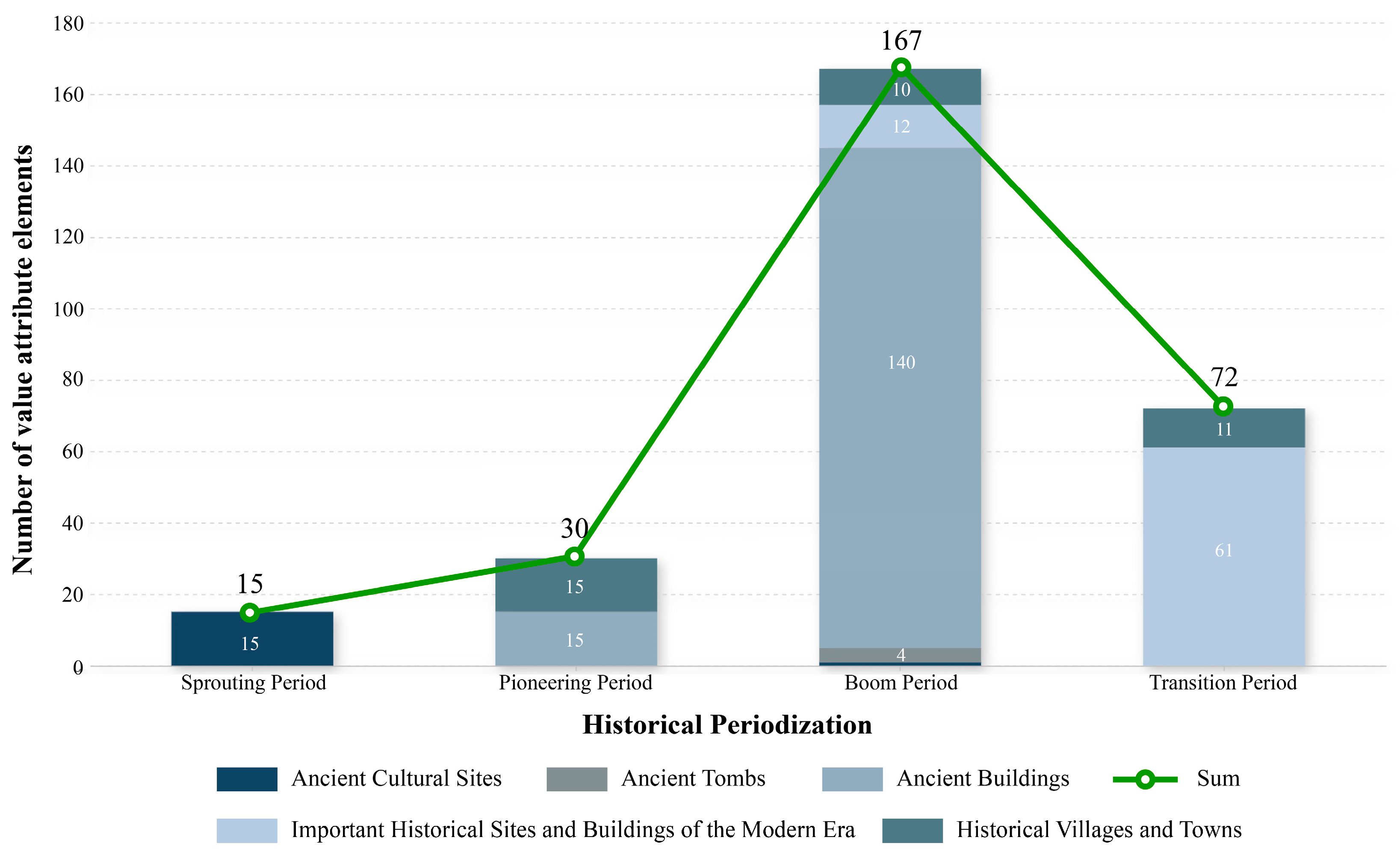
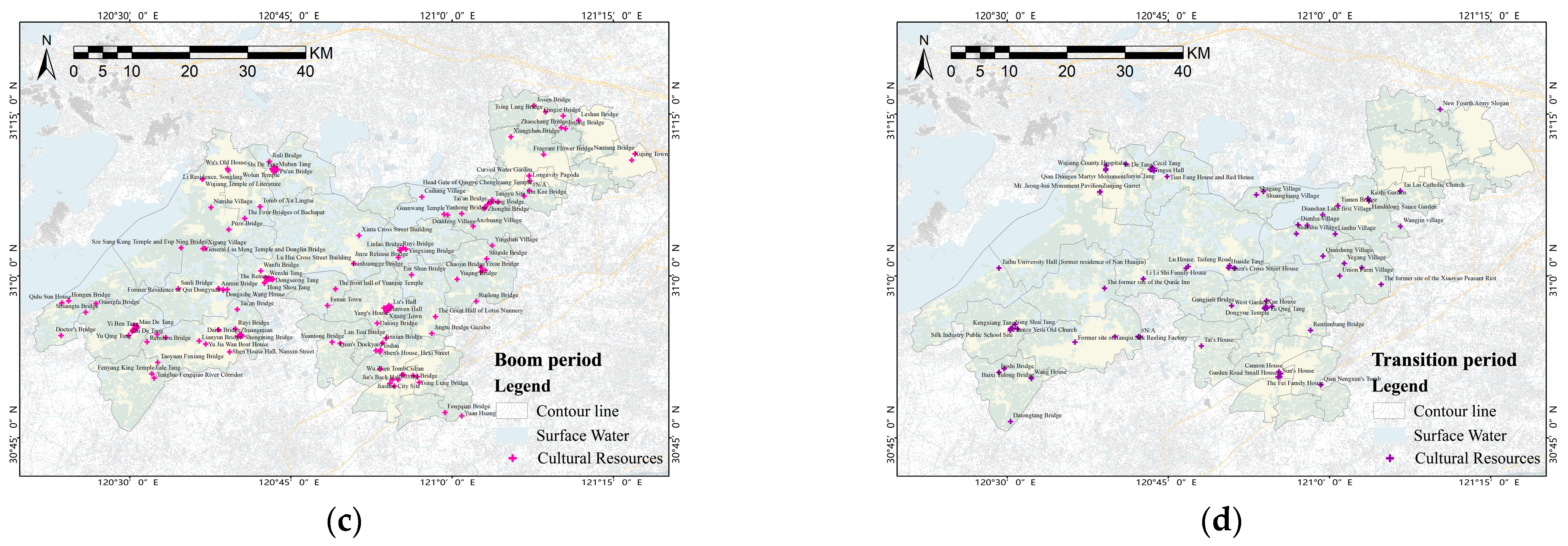
3.1.2. Historical Geography Analysis
3.1.3. Core Value System and Classification of Value Attribute Elements
3.2. Regional Cultural Landscape Security Assessment Results
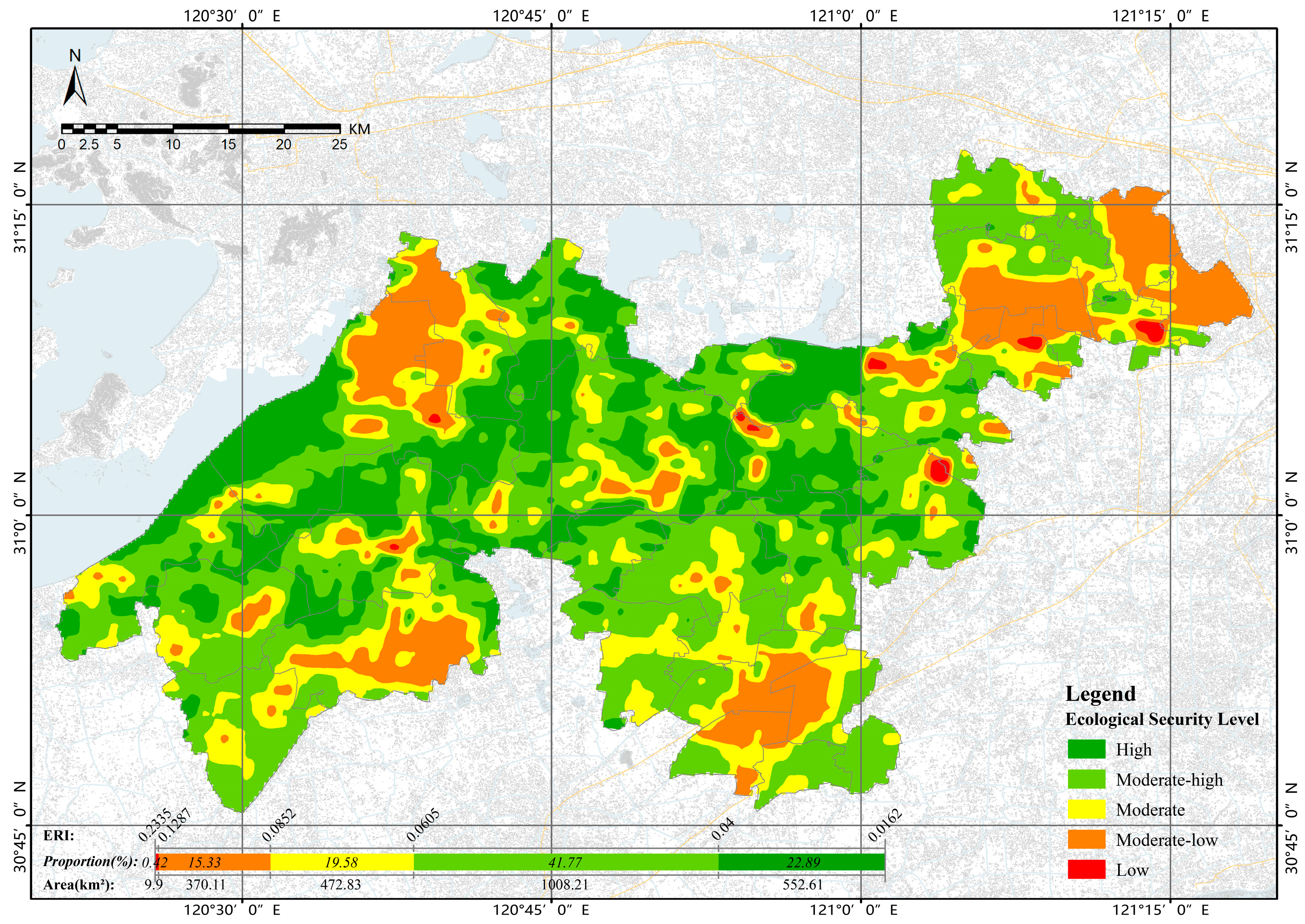
3.2.1. Ecological Security Assessment Results
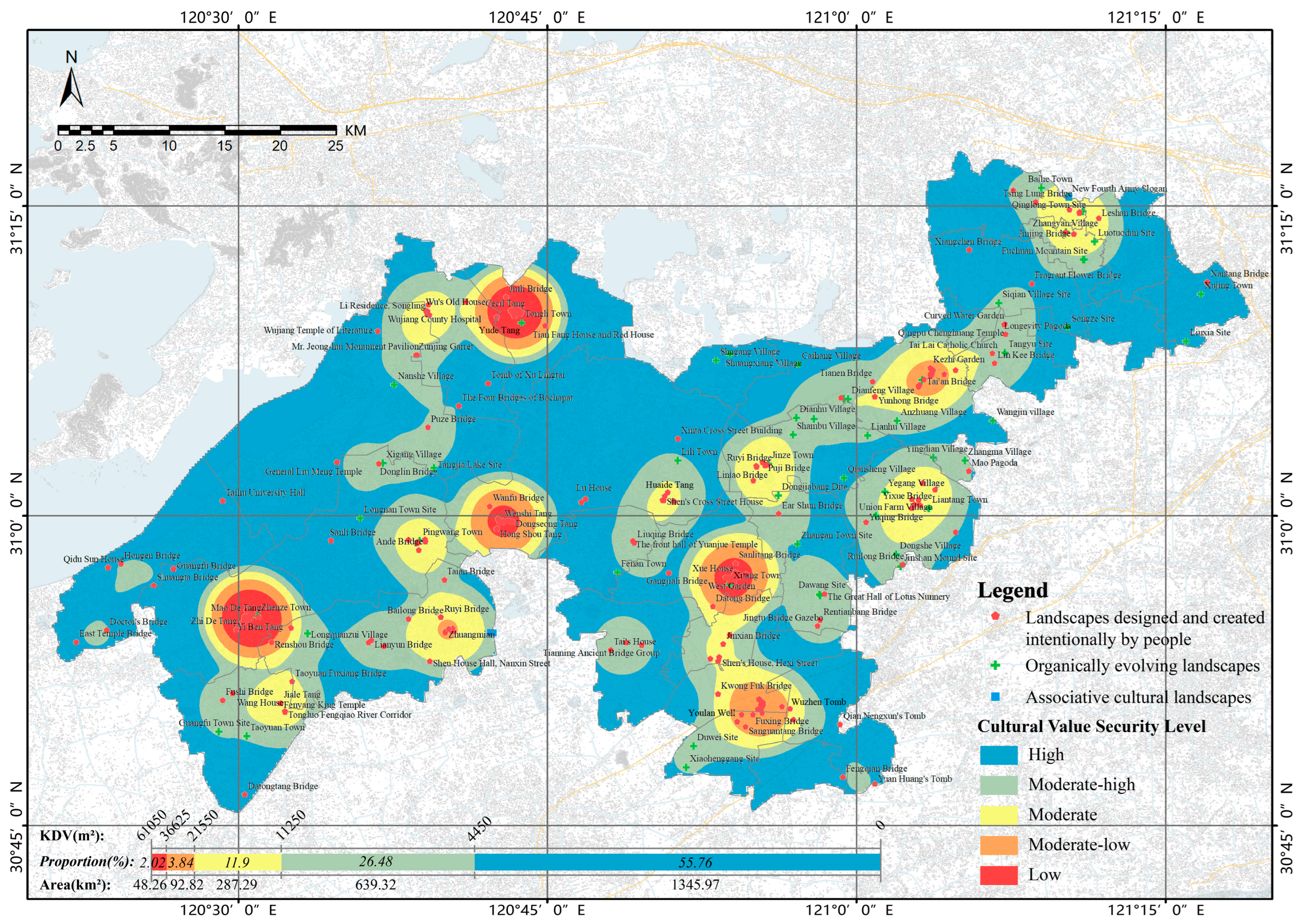
3.2.2. Cultural Value Security Assessment Results
3.3. Identification of Security Patterns in Vernacular Cultural Landscapes and the Formulation of Optimization Strategies for Key Protected Areas
3.3.1. Comprehensive Assessment Results and Security Level Division
3.3.2. Grading Strategy Guidance for Key Conservation Areas
4. Discussion
4.1. Importance of Natural–Cultural Methodology
4.2. Security Pattern Indicators for Integrated Conservation
4.3. Limitations and Future Research
5. Conclusions
Author Contributions
Funding
Data Availability Statement
Conflicts of Interest
Appendix A

| Number | Name | lat | lng | Value Importance | Value Quality | Value Security |
|---|---|---|---|---|---|---|
| 1 | Tongli Ancient Town | 120.729409 | 31.156127 | 95 | 95 | 95 |
| 2 | Zhenze Ancient Town | 120.515654 | 30.918912 | 90 | 93 | 91.5 |
| 3 | Lili Ancient Town | 120.855612 | 31.044517 | 92 | 93 | 92.5 |
| 4 | Zhujiajiao Ancient Town | 121.053045 | 31.109589 | 93 | 94 | 93.5 |
| 5 | Liantang Ancient Town | 121.058726 | 31.005866 | 90 | 86 | 88 |
| 6 | Jinze Ancient Town | 120.928882 | 31.041805 | 90 | 88 | 89 |
| 7 | Xitang Ancient Town | 120.897876 | 30.94479 | 95 | 95 | 95 |
| 8 | Pingwang Town | 120.64669 | 30.97991 | 88 | 85 | 86.5 |
| 9 | Taoyuan Town | 120.506958 | 30.822237 | 85 | 80 | 82.5 |
| 10 | Xujing Town | 121.278826 | 31.178794 | 82 | 81 | 81.5 |
| 11 | Baihe Town | 121.149703 | 31.264801 | 85 | 82 | 83.5 |
| 12 | Chonggu Town | 121.184522 | 31.206799 | 86 | 84 | 85 |
| 13 | Fenan Town | 120.807037 | 30.954243 | 81 | 80 | 80.5 |
| 14 | Zhangxing Village | 120.970256 | 30.936375 | 81 | 75 | 78 |
| 15 | Zhangyan Village | 121.169565 | 31.229108 | 80 | 79 | 79.5 |
| 16 | Qinglong Village | 121.183233 | 31.245574 | 79 | 82 | 80.5 |
| 17 | Wangjin Village | 121.110524 | 31.076721 | 73 | 74 | 73.5 |
| 18 | Zhanglian Village | 120.965796 | 31.078236 | 73 | 78 | 75.5 |
| 19 | Shuangxiang Village | 120.897858 | 31.13039 | 78 | 76 | 77 |
| 20 | Shagang Village | 120.886904 | 31.125318 | 73 | 73 | 73 |
| 21 | Qiansheng Village | 120.990281 | 31.030522 | 71 | 70 | 70.5 |
| 22 | Shambu Village | 120.949015 | 31.06539 | 75 | 75 | 75 |
| 23 | Lianhu Village | 121.009105 | 31.064915 | 73 | 71 | 72 |
| 24 | Caihang Village | 120.953336 | 31.122277 | 72 | 74 | 73 |
| 25 | Dianhu Village | 120.951503 | 31.079105 | 71 | 76 | 73.5 |
| 26 | Dianshan Lake first Village | 120.989934 | 31.094466 | 72 | 82 | 77 |
| 27 | Dianfeng Village | 120.993589 | 31.094121 | 74 | 78 | 76 |
| 28 | Anzhuang Village | 121.03287 | 31.076665 | 68 | 74 | 71 |
| 29 | Zhangma Village | 121.08779 | 31.044714 | 65 | 76 | 70.5 |
| 30 | Yegang Village | 121.023059 | 31.019513 | 67 | 80 | 73.5 |
| 31 | Yingdian Village | 121.062235 | 31.047116 | 65 | 79 | 72 |
| 32 | Union Farm Village | 121.016078 | 30.999997 | 66 | 76 | 71 |
| 33 | Dongshe Village | 121.032412 | 30.969005 | 69 | 84 | 76.5 |
| 34 | Nanshe Village | 120.626398 | 31.105811 | 65 | 80 | 72.5 |
| 35 | Longquanzui Village | 120.556104 | 30.904932 | 61 | 66 | 63.5 |
| 36 | Xigang Village | 120.617056 | 31.042511 | 60 | 70 | 65 |
| 37 | Songze Site | 121.171145 | 31.152176 | 95 | 95 | 95 |
| 38 | Fuchuan Mountain Site | 121.183492 | 31.206747 | 94 | 91 | 92.5 |
| 39 | Qinglong Town Site | 121.17155 | 31.257998 | 92 | 90 | 91 |
| 40 | Siqian Village Site | 121.115228 | 31.171707 | 88 | 75 | 81.5 |
| 41 | Jinshan Mound Site | 121.036001 | 30.9592 | 82 | 50 | 66 |
| 42 | Liuxia Site | 121.267137 | 31.140878 | 80 | 45 | 62.5 |
| 43 | Qinglong Pagoda | 121.180624 | 31.244487 | 82 | 90 | 86 |
| 44 | Mao Pagoda | 121.09107 | 31.036254 | 84 | 90 | 87 |
| 45 | Tangyu Site | 121.06245 | 31.117805 | 86 | 88 | 87 |
| 46 | Yingxiang Bridge | 120.928317 | 31.041207 | 84 | 80 | 82 |
| 47 | Puji Bridge | 120.926263 | 31.040683 | 86 | 84 | 85 |
| 48 | Chen Yun’s former residence | 121.050436 | 31.012765 | 80 | 90 | 85 |
| 49 | Curved Water Garden | 121.120401 | 31.154828 | 82 | 86 | 84 |
| 50 | Longevity Pagoda | 121.120868 | 31.146783 | 80 | 80 | 80 |
| 51 | Luotuodun Site | 121.192889 | 31.221306 | 78 | 50 | 64 |
| 52 | Tsing Lung Temple | 121.180964 | 31.245533 | 76 | 80 | 78 |
| 53 | Tsing Lung Bridge | 121.145328 | 31.253453 | 70 | 70 | 70 |
| 54 | Wanan Bridge | 121.080362 | 31.117621 | 73 | 60 | 66.5 |
| 55 | Shunde Bridge | 121.053717 | 31.026585 | 72 | 62 | 67 |
| 56 | Qingze Bridge | 121.172659 | 31.247044 | 72 | 63 | 67.5 |
| 57 | Guanwang Temple | 120.987914 | 31.09538 | 70 | 70 | 70 |
| 58 | Yihao Chan Temple Site | 120.927051 | 31.041083 | 73 | 75 | 74 |
| 59 | The former site of the Xiaoyao Peasant Riot | 121.08041 | 30.986988 | 68 | 64 | 66 |
| 60 | Head Gate of Qingpu Chenghuang Temple | 121.11981 | 31.154384 | 70 | 80 | 75 |
| 61 | New Fourth Army Slogan | 121.171916 | 31.257227 | 60 | 34 | 47 |
| 62 | Kezhi Garden | 121.05997 | 31.119531 | 69 | 80 | 74.5 |
| 63 | Ruyi Bridge | 120.919126 | 31.040317 | 68 | 60 | 64 |
| 64 | Linlao Bridge | 120.919534 | 31.039489 | 70 | 62 | 66 |
| 65 | Tianhuangge Bridge | 120.916712 | 31.028715 | 71 | 60 | 65.5 |
| 66 | Jinze Release Bridge | 120.924308 | 31.043574 | 70 | 60 | 65 |
| 67 | Nantang Bridge | 121.284073 | 31.188798 | 68 | 60 | 64 |
| 68 | Jinjing Bridge | 121.175994 | 31.227575 | 70 | 60 | 65 |
| 69 | Leshan Bridge | 121.196269 | 31.240314 | 68 | 60 | 64 |
| 70 | Yongxing Bridge | 121.045104 | 31.006345 | 70 | 60 | 65 |
| 71 | Tianguang Temple | 121.063823 | 31.021106 | 75 | 80 | 77.5 |
| 72 | Yixue Bridge | 121.047218 | 31.009278 | 68 | 60 | 64 |
| 73 | Chaojin Bridge | 121.051563 | 31.008745 | 73 | 60 | 66.5 |
| 74 | The old classrooms of Yan’an Primary School | 121.04515 | 31.013393 | 75 | 78 | 76.5 |
| 75 | Ruilong Bridge | 121.037745 | 30.960832 | 70 | 60 | 65 |
| 76 | Yuqing Bridge | 121.008069 | 30.994987 | 75 | 60 | 67.5 |
| 77 | Fragrant Flower Bridge | 121.142249 | 31.18759 | 70 | 60 | 65 |
| 78 | Xiangchen Bridge | 121.091335 | 31.214668 | 69 | 60 | 64.5 |
| 79 | Lin Kee Bridge | 121.112064 | 31.123307 | 70 | 60 | 65 |
| 80 | Jissen Bridge | 121.127249 | 31.263041 | 69 | 60 | 64.5 |
| 81 | Tong Yu Site | 121.120422 | 31.131555 | 70 | 56 | 63 |
| 82 | Tai Lai Catholic Church | 121.110117 | 31.131337 | 72 | 78 | 75 |
| 83 | Tianen Bridge | 121.013478 | 31.10857 | 65 | 60 | 62.5 |
| 84 | Jiufeng Bridge | 121.071155 | 31.114481 | 70 | 60 | 65 |
| 85 | Qing Dynasty Post Office Site | 121.060079 | 31.113168 | 73 | 78 | 75.5 |
| 86 | Tai’an Bridge | 121.054973 | 31.110267 | 72 | 60 | 66 |
| 87 | Handalong Sauce Garden | 121.061579 | 31.115996 | 73 | 78 | 75.5 |
| 88 | Fuxing Bridge | 121.050568 | 31.105114 | 68 | 60 | 64 |
| 89 | Zhonghe Bridge | 121.051378 | 31.105702 | 68 | 60 | 64 |
| 90 | Yunhong Bridge | 121.015269 | 31.096402 | 68 | 60 | 64 |
| 91 | Tong Tin Ho Chinese Medicine Shop | 121.061094 | 31.114157 | 70 | 78 | 74 |
| 92 | Xi Family Residence | 121.050343 | 31.104315 | 70 | 58 | 64 |
| 93 | Zhujiajiao Town God’s Temple | 121.060348 | 31.114728 | 75 | 85 | 80 |
| 94 | Zhaochang Bridge | 121.169565 | 31.229108 | 69 | 65 | 67 |
| 95 | East Temple Bridge | 120.368994 | 30.898316 | 90 | 60 | 75 |
| 96 | Sze Pun Bridge | 120.709237 | 31.160832 | 90 | 62 | 76 |
| 97 | Chui Hung Broken Bridge | 120.654983 | 31.162228 | 93 | 74 | 83.5 |
| 98 | Keng Lok Tong | 120.721973 | 31.164198 | 91 | 88 | 89.5 |
| 99 | Shijian Hall | 120.510441 | 30.918847 | 92 | 86 | 89 |
| 100 | Retreat Garden | 120.726231 | 31.164274 | 94 | 90 | 92 |
| 101 | Silkworm Ancestral Shrine | 120.67316 | 30.90905 | 93 | 84 | 88.5 |
| 102 | Ciyun Temple Pagoda | 120.511762 | 30.921092 | 92 | 86 | 89 |
| 103 | The former residence of Liu Yazi | 120.717908 | 30.995118 | 90 | 92 | 91 |
| 104 | Longnan Town Site | 120.598978 | 30.997913 | 88 | 60 | 74 |
| 105 | Guangfu Town Site | 120.484391 | 30.825695 | 87 | 55 | 71 |
| 106 | Wang Xi Huan’s Tomb | 120.505276 | 30.916849 | 85 | 90 | 87.5 |
| 107 | Tomb of Xu Lingtai | 120.702282 | 31.107132 | 84 | 88 | 86 |
| 108 | Fragrant Flower Bridge | 120.510221 | 30.910442 | 86 | 90 | 88 |
| 109 | Hongen Bridge | 120.40546 | 30.961312 | 84 | 82 | 83 |
| 110 | Guangfu Bridge | 120.447762 | 30.957369 | 80 | 68 | 74 |
| 111 | Zhonghe Bridge | 120.50686 | 30.923777 | 81 | 72 | 76.5 |
| 112 | Hong Shou Tang | 120.709343 | 30.989117 | 80 | 76 | 78 |
| 113 | Zhi De Tang | 120.498746 | 30.908417 | 86 | 78 | 82 |
| 114 | Chongben Tang | 120.723982 | 31.164525 | 84 | 83 | 83.5 |
| 115 | Zhougongfu Ancestral Shrine | 120.713709 | 30.994047 | 87 | 89 | 88 |
| 116 | The former residence of Chen Zhaodi | 120.723366 | 31.160969 | 85 | 88 | 86.5 |
| 117 | Tomb of Martyr Zhang Yingchun | 120.781039 | 31.014765 | 82 | 84 | 83 |
| 119 | Wujiang Temple of Literature | 120.613008 | 31.149287 | 86 | 71 | 78.5 |
| 120 | Japanese Artillery Building No. 75 on the Sukha Railway | 120.706107 | 30.905492 | 80 | 83 | 81.5 |
| 121 | Jiayin Tang | 120.7244 | 31.164022 | 81 | 80 | 80.5 |
| 122 | Duanben Garden | 120.718542 | 30.996044 | 80 | 85 | 82.5 |
| 123 | Qian Diangen Martyr Monument | 120.653004 | 31.163385 | 78 | 79 | 78.5 |
| 124 | Anmin Bridge | 120.638047 | 30.980856 | 79 | 82 | 80.5 |
| 125 | Shengming Bridge | 120.674519 | 30.907203 | 72 | 88 | 80 |
| 126 | Muben Tang | 120.727409 | 31.16314 | 74 | 85 | 79.5 |
| 127 | Yushu Bridge | 120.512252 | 30.921134 | 78 | 67 | 72.5 |
| 128 | Xu Dayuan’s former residence | 120.713706 | 30.995183 | 70 | 74 | 72 |
| 129 | Jidong Association Hall | 120.670572 | 30.908735 | 73 | 71 | 72 |
| 130 | Dongseong Tang | 120.722271 | 30.995176 | 71 | 76 | 73.5 |
| 131 | The Retreat | 120.709547 | 30.989853 | 78 | 58 | 68 |
| 132 | Tai’an Bridge | 120.666908 | 30.948381 | 73 | 60 | 66.5 |
| 133 | Ande Bridge | 120.64608 | 30.972471 | 80 | 75 | 77.5 |
| 134 | Sanli Bridge | 120.575341 | 30.980146 | 78 | 75 | 76.5 |
| 135 | Bailong Bridge | 120.637818 | 30.916989 | 71 | 80 | 75.5 |
| 136 | The former residence of the Southern Society Communication Office | 120.715077 | 30.995344 | 70 | 68 | 69 |
| 137 | Former residence of Zhang Yingchun | 120.777911 | 31.011913 | 72 | 80 | 76 |
| 138 | Tian Fang House and Red House | 120.748353 | 31.153648 | 70 | 75 | 72.5 |
| 139 | Silk Industry Public School Site | 120.506687 | 30.918705 | 74 | 86 | 80 |
| 140 | Wolun Temple | 120.720806 | 31.165752 | 69 | 60 | 64.5 |
| 141 | Puze Bridge | 120.65366 | 31.071503 | 68 | 62 | 65 |
| 142 | Fuguan Bridge | 120.723685 | 31.167235 | 70 | 72 | 71 |
| 143 | Sifan Bridge | 120.503823 | 30.914191 | 78 | 80 | 79 |
| 144 | Shuangta Bridge | 120.431871 | 30.943912 | 76 | 78 | 77 |
| 145 | Zhengxiu Tang | 120.507828 | 30.917517 | 60 | 50 | 55 |
| 146 | Pang’s Ancestral Shrine | 120.724911 | 31.167191 | 63 | 55 | 59 |
| 147 | Former residence of Yang Tianji | 120.727382 | 31.165846 | 71 | 58 | 64.5 |
| 148 | Kengxiang Tang | 120.516317 | 30.918297 | 66 | 52 | 59 |
| 149 | Zunjing Garret | 120.643807 | 31.129982 | 72 | 74 | 73 |
| 150 | Wang House | 120.537912 | 30.842366 | 62 | 75 | 68.5 |
| 151 | Shen’s Cross Street House | 120.844386 | 31.012417 | 70 | 80 | 75 |
| 152 | Huaide Tang | 120.843496 | 31.012942 | 63 | 66 | 64.5 |
| 153 | Tangjia Lake Site | 120.658513 | 31.038552 | 74 | 38 | 56 |
| 154 | The Four Bridges of Bachapat | 120.678599 | 31.088797 | 67 | 60 | 63.5 |
| 155 | Wu’s former residence | 120.651911 | 31.165921 | 61 | 65 | 63 |
| 156 | Yi Ben Tang | 120.507869 | 30.916808 | 61 | 61 | 61 |
| 157 | Ning Shui Tang | 120.50841 | 30.919251 | 63 | 58 | 60.5 |
| 158 | Mao De Tang | 120.510477 | 30.91918 | 62 | 54 | 58 |
| 159 | Ning Qing Tang | 120.510221 | 30.919563 | 64 | 57 | 60.5 |
| 160 | Jing Sheng Tang | 120.508889 | 30.916754 | 64 | 67 | 65.5 |
| 161 | Yu Qing Tang | 120.506673 | 30.917153 | 72 | 70 | 71 |
| 162 | Shang Yi Tang | 120.506997 | 30.915875 | 60 | 60 | 60 |
| 163 | Lianyun Bridge | 120.607888 | 30.89967 | 69 | 78 | 73.5 |
| 164 | Zhuangmian | 120.667925 | 30.90674 | 68 | 61 | 64.5 |
| 165 | Qidu Sun House | 120.394905 | 30.958343 | 65 | 63 | 64 |
| 166 | Purification Lake Daoist Temple and Qiuqi Bridge | 120.710603 | 30.99725 | 60 | 60 | 60 |
| 167 | Xinta Cross Street Building | 120.855985 | 31.062429 | 66 | 78 | 72 |
| 168 | Shi De Tang | 120.726342 | 31.162958 | 62 | 80 | 71 |
| 169 | Qing Shan Tang | 120.727005 | 31.166453 | 68 | 84 | 76 |
| 170 | Zhu Residence in Tongli | 120.72393 | 31.161502 | 60 | 55 | 57.5 |
| 171 | Pu’an Bridge | 120.729035 | 31.164507 | 69 | 71 | 70 |
| 172 | Tongli Three Bridges | 120.72387 | 31.164403 | 72 | 75 | 73.5 |
| 173 | Yu De Tang | 120.727768 | 31.162633 | 62 | 60 | 61 |
| 174 | Xiaojiuhua Temple Jizang Spring Well | 120.651433 | 30.979237 | 61 | 63 | 62 |
| 175 | General Liu Meng Temple and Donglin Bridge | 120.613861 | 31.042351 | 68 | 75 | 71.5 |
| 176 | Fenyang King Temple | 120.534575 | 30.848996 | 70 | 70 | 70 |
| 177 | Jiale Tang | 120.534575 | 30.848996 | 71 | 75 | 73 |
| 178 | Fushi Bridge | 120.48756 | 30.851369 | 68 | 53 | 60.5 |
| 179 | Sze Sang Kung Temple and Eup Ning Bridge | 120.579964 | 31.043533 | 62 | 64 | 63 |
| 180 | Doctor’s Bridge | 120.39374 | 30.90786 | 60 | 50 | 55 |
| 181 | Pang Shan Lake Farm Watchtower | 120.684287 | 31.173027 | 61 | 63 | 62 |
| 182 | No. 166 Yau Che Road Republican Building | 120.653976 | 31.170419 | 65 | 78 | 71.5 |
| 183 | Sujia Railway Pier | 120.70423 | 30.90613 | 67 | 77 | 72 |
| 184 | Mr. Jeong-hui Monument Pavilion | 120.644947 | 31.129903 | 66 | 70 | 68 |
| 185 | Zhenze Yesu Old Church | 120.505021 | 30.915778 | 60 | 60 | 60 |
| 186 | Li Li Catholic Church | 120.722246 | 30.99484 | 64 | 76 | 70 |
| 187 | Li Li Shi Family House | 120.711545 | 30.995664 | 64 | 60 | 62 |
| 188 | Nan Yuan Tea House | 120.723296 | 31.161786 | 61 | 71 | 66 |
| 189 | Former Residence of Wang Shaoguan | 120.724752 | 31.164875 | 60 | 65 | 62.5 |
| 190 | Former residence of Qin Dongyuan | 120.645261 | 30.979054 | 65 | 67 | 66 |
| 191 | Dongxihe Wang House | 120.645045 | 30.978191 | 63 | 55 | 59 |
| 192 | Daifu Bridge | 120.673298 | 30.907039 | 60 | 52 | 56 |
| 193 | Qixintang Pharmacy | 120.673298 | 30.907039 | 62 | 60 | 61 |
| 194 | Renshou Bridge | 120.527132 | 30.898234 | 60 | 50 | 55 |
| 195 | Wanfu Bridge | 120.703461 | 31.007839 | 50 | 48 | 49 |
| 196 | Zheng’an Bridge | 120.510618 | 30.923135 | 63 | 52 | 57.5 |
| 197 | Wenshi Tang | 120.712976 | 30.995081 | 60 | 57 | 58.5 |
| 198 | Yu Jia Wan Boat House | 120.617874 | 30.89503 | 64 | 67 | 65.5 |
| 199 | Cecil Tang | 120.722397 | 31.164754 | 68 | 59 | 63.5 |
| 200 | Pui Yuen Public House 30th Anniversary Well | 120.66764 | 30.905944 | 61 | 55 | 58 |
| 201 | Wujiang County Hospital | 120.653282 | 31.165165 | 67 | 78 | 72.5 |
| 202 | Jingsu Hall | 120.725572 | 31.165016 | 60 | 56 | 58 |
| 203 | Taihu University Hall | 120.487584 | 31.01211 | 65 | 79 | 72 |
| 204 | The former site of the Qunle Inn | 120.651146 | 30.980935 | 64 | 78 | 71 |
| 205 | Ruyi Bridge | 120.664112 | 30.918272 | 60 | 53 | 56.5 |
| 206 | Former site of Shengji Silk House | 120.542937 | 30.909812 | 61 | 55 | 58 |
| 207 | Wu Residence, Baoshu Hall | 120.509569 | 30.919234 | 60 | 51 | 55.5 |
| 208 | Former site of Jiangfeng Agricultural and Industrial Bank | 120.505528 | 30.918705 | 62 | 76 | 69 |
| 209 | Datongtang Bridge | 120.505461 | 30.775092 | 60 | 45 | 52.5 |
| 210 | Jiuli Bridge | 120.716878 | 31.176748 | 60 | 70 | 65 |
| 211 | Tongluo Fengqiao River Corridor | 120.538146 | 30.842225 | 68 | 68 | 68 |
| 212 | The former site of the Taihu Water Conservancy Governor’s Office | 120.723508 | 31.164551 | 73 | 78 | 75.5 |
| 213 | Lu Hui Cross Street Building | 120.847512 | 31.019027 | 70 | 80 | 75 |
| 214 | Mao House, Maojia Lang | 120.719829 | 30.995231 | 60 | 64 | 62 |
| 215 | Wang House, Center Street | 120.720103 | 30.995018 | 61 | 66 | 63.5 |
| 216 | Wang House, Wangjialiang | 120.720171 | 30.995483 | 60 | 65 | 62.5 |
| 217 | Lu House, Taifeng Road | 120.845324 | 31.016048 | 60 | 63 | 61.5 |
| 218 | Ding House, Dingjialang | 120.713999 | 30.994956 | 60 | 61 | 60.5 |
| 219 | Khoo Residence, Centre Street | 120.717296 | 30.995251 | 61 | 65 | 63 |
| 220 | Shen House Hall, Nanxin Street | 120.655238 | 30.882743 | 60 | 63 | 61.5 |
| 221 | Li Residence, Songling | 120.653165 | 31.162895 | 60 | 67 | 63.5 |
| 222 | Taoyuan Fuxiang Bridge | 120.543724 | 30.866327 | 61 | 55 | 58 |
| 223 | Taian Bridge, Songling | 120.723467 | 31.163225 | 62 | 51 | 56.5 |
| 224 | Former site of Zhenfeng Silk Reeling Factory | 120.512848 | 30.925081 | 64 | 70 | 67 |
| 225 | The former site of Li Zi Kiln | 120.852637 | 31.011903 | 60 | 68 | 64 |
| 226 | Baixi Yulong Bridge | 120.495682 | 30.856983 | 62 | 45 | 53.5 |
| 227 | Former site of Tanqiu Silk Reeling Factory | 120.605635 | 30.897941 | 68 | 80 | 74 |
| 228 | The former site of the Communist Party of China East Special Committee of West Zhejiang Road and the Communist Party of China Wuxing County Committee | 120.538128 | 30.841744 | 62 | 58 | 60 |
| 229 | Wu Zhen Tomb | 120.922884 | 30.847286 | 90 | 90 | 90 |
| 230 | Dawang Site | 120.970861 | 30.93571 | 86 | 50 | 68 |
| 231 | Yodun | 120.88838 | 30.882704 | 85 | 70 | 77.5 |
| 232 | Qian’s Dockyard | 120.882095 | 30.884853 | 80 | 74 | 77 |
| 233 | Weitang Ye Residence | 120.939953 | 30.846282 | 78 | 50 | 64 |
| 234 | Xitang Architectural Complex | 120.894666 | 30.950463 | 90 | 92 | 91 |
| 235 | Tianning Ancient Bridge Group | 120.826563 | 30.895785 | 86 | 70 | 78 |
| 236 | Duwei Site | 120.868483 | 30.814011 | 75 | 50 | 62.5 |
| 237 | Xiaohenggang Site | 120.862542 | 30.797007 | 75 | 50 | 62.5 |
| 238 | Zhangan Town Site | 120.952421 | 30.977189 | 75 | 50 | 62.5 |
| 239 | Jingtu Bridge Gazebo | 120.968774 | 30.911117 | 74 | 80 | 77 |
| 240 | Liuqing Bridge | 120.820659 | 30.978492 | 72 | 62 | 67 |
| 241 | Jiashan Martyrs’ Cemetery | 120.924598 | 30.84914 | 80 | 85 | 82.5 |
| 242 | The front hall of Yuanjue Temple | 120.819438 | 30.979759 | 70 | 73 | 71.5 |
| 243 | The Great Hall of Lotus Nunnery | 120.974405 | 30.937235 | 72 | 73 | 72.5 |
| 244 | Cishan | 120.924796 | 30.847353 | 77 | 80 | 78.5 |
| 245 | Yuantong Bridge | 120.814157 | 30.897813 | 78 | 60 | 69 |
| 246 | Sanguantang Bridge | 120.910578 | 30.829906 | 72 | 60 | 66 |
| 247 | Fengqian Bridge | 120.989276 | 30.78931 | 72 | 60 | 66 |
| 248 | Dongyue Temple | 120.911057 | 30.953093 | 78 | 80 | 79 |
| 249 | Qian Nengxun’s Tomb | 120.987015 | 30.83176 | 70 | 70 | 70 |
| 250 | Yuan Huang’s Tomb | 121.0151 | 30.783785 | 72 | 50 | 61 |
| 251 | Jiashan City Site | 120.907356 | 30.839562 | 70 | 60 | 65 |
| 252 | Jin’s Back Hall | 120.903752 | 30.834035 | 72 | 60 | 66 |
| 253 | Lu’s Hall | 120.904614 | 30.950377 | 72 | 50 | 61 |
| 254 | Zunwen Hall | 120.897658 | 30.950225 | 71 | 70 | 70.5 |
| 255 | County Chancellor’s Office | 120.89772 | 30.947164 | 69 | 60 | 64.5 |
| 256 | Yongshou Zen Temple | 120.902337 | 30.95465 | 68 | 60 | 64 |
| 257 | Youlan Spring | 120.924016 | 30.841044 | 75 | 55 | 65 |
| 258 | West Garden | 120.8994 | 30.949884 | 65 | 78 | 71.5 |
| 259 | Xue House | 120.900143 | 30.950839 | 58 | 50 | 54 |
| 260 | Sun’s House | 120.923437 | 30.844188 | 60 | 50 | 55 |
| 261 | Shen De Tang | 120.897527 | 30.950131 | 64 | 60 | 62 |
| 262 | Shen’s House, Hexi Street | 120.889212 | 30.885903 | 62 | 58 | 60 |
| 263 | Yang’s House | 120.90225 | 30.952499 | 63 | 58 | 60.5 |
| 264 | Jinxian Bridge | 120.892572 | 30.896668 | 70 | 59 | 64.5 |
| 265 | Fuyuan Bridge | 120.905742 | 30.952843 | 67 | 60 | 63.5 |
| 266 | Lan Tsui Bridge | 120.897668 | 30.903937 | 66 | 60 | 63 |
| 267 | Datong Bridge | 120.884189 | 30.926954 | 66 | 60 | 63 |
| 268 | Yu Qing Tang | 120.903199 | 30.950705 | 69 | 60 | 64.5 |
| 269 | Shui Yang House | 120.903676 | 30.950638 | 65 | 53 | 59 |
| 270 | Tai’s House | 120.801496 | 30.891862 | 63 | 50 | 56.5 |
| 271 | Cannon House | 120.921783 | 30.852123 | 65 | 65 | 65 |
| 272 | Sanlitang Bridge | 120.902565 | 30.961748 | 62 | 60 | 61 |
| 273 | Gangjiali Bridge | 120.848553 | 30.954163 | 60 | 60 | 60 |
| 274 | Rentianbang Bridge | 120.970963 | 30.915933 | 60 | 60 | 60 |
| 275 | Garden Road Small House | 120.923315 | 30.849051 | 67 | 70 | 68.5 |
| 276 | Protecting the Country with the Grain King Temple | 120.894692 | 30.950436 | 73 | 68 | 70.5 |
| 277 | Former Residence of Zhao Xianchu | 120.901417 | 30.952847 | 68 | 70 | 69 |
| 278 | Dongjiabang Dite | 120.936967 | 31.016308 | 78 | 38 | 58 |
| 279 | Chung Kai Fook Pharmacy | 120.90132 | 30.947119 | 68 | 60 | 64 |
| 280 | Ear Shun Bridge | 120.937393 | 31.001734 | 68 | 56 | 62 |
| 281 | Tsing Lung Bridge | 120.946497 | 30.84447 | 67 | 60 | 63.5 |
| 282 | Guangfu Bridge | 120.888313 | 30.856209 | 66 | 60 | 63 |
| 283 | Gu Family Hall and River Port | 120.949093 | 30.835458 | 68 | 55 | 61.5 |
| 284 | The Fei Family House | 120.920349 | 30.84427 | 60 | 45 | 52.5 |
References
- Meinig, D.W. Reading the landscape: An appreciation of WG Hoskins and JB Jackson. Interpret. Ordinary Landsc. Geogr. Essays 1979, 195–244. [Google Scholar]
- Jackson, J.B. Discovering the Vernacular Landscape, 1st ed.; Yale University Press: New Haven, CT, USA, 1984; p. 165. [Google Scholar]
- Eben Saleh, M.A. A1-Alkhalaf vernacular landscape: The planning and management of land in an insular context, Asir region, southwestern Saudi Arabia. Landsc. Urban Plan. 1996, 34, 79–95. [Google Scholar] [CrossRef]
- ICOMOS. ICOMOS-IFLA Principles Concerning Rural Landscapes as Heritage. Available online: https://www.icomos.org/images/DOCUMENTS/Charters/GA2017_6-3-1_RuralLandscapesPrinciples_EN_adopted-15122017.pdf (accessed on 27 February 2023).
- Council of Europe. Council of Europe Landscape Convention. Available online: https://rm.coe.int/16807b6bc7 (accessed on 4 March 2023).
- Jenkins, V. Protecting the natural and cultural heritage of local landscapes: Finding substance in law and legal decision making. Land Use Policy 2018, 73, 73–83. [Google Scholar] [CrossRef]
- Plieninger, T.; van der Horst, D.; Schleyer, C.; Bieling, C. Sustaining ecosystem services in cultural landscapes. Ecol. Soc. 2014, 19, 59. [Google Scholar] [CrossRef]
- Matthews, R.; Selman, P. Landscape as a focus for integrating human and environmental processes. J. Agric. Econ. 2006, 57, 199–212. [Google Scholar] [CrossRef]
- Duncan, J.; Duncan, N. Landscapes of Privilege, 1st ed.; Routledge: London, UK, 2004; pp. 26–32. [Google Scholar]
- Dong, Q.; Wu, L.; Cai, J.; Li, D.; Chen, Q. Construction of Ecological and Recreation Patterns in Rural Landscape Space: A Case Study of the Dujiangyan Irrigation District in Chengdu, China. Land 2022, 11, 383. [Google Scholar] [CrossRef]
- Hermann, A.; Kuttner, M.; Hainz-Renetzeder, C.; Konkoly-Gyuró, É.; Tirászi, Á.; Brandenburg, C.; Allex, B.; Ziener, K.; Wrbka, T. Assessment framework for landscape services in European cultural landscapes: An Austrian Hungarian case study. Ecol. Indic. 2014, 37, 229–240. [Google Scholar] [CrossRef]
- Cook, I.; Johnston, R.; Selby, K. Climate Change and Cultural Heritage: A Landscape Vulnerability Framework. Joural Isl. Coast. Archaeol. 2021, 16, 553–571. [Google Scholar] [CrossRef]
- Xiao, D.; Chen, W. On the basic concepts and contents of ecological security. J. Appl. Ecol. 2002, 13, 354–358. [Google Scholar]
- Bai, X.; Du, P.; Guo, S.; Zhang, P.; Lin, C.; Tang, P.; Zhang, C. Monitoring land cover change and disturbance of the mount wutai world cultural landscape heritage protected area, based on remote Sensing time-Series images from 1987 to 2018. Remote Sens. 2019, 11, 1332. [Google Scholar] [CrossRef]
- Kang, J.; Zhang, X.; Zhu, X.; Zhang, B. Ecological security pattern: A new idea for balancing regional development and ecological protection. A case study of the Jiaodong Peninsula, China. Glob. Ecol. Conserv. 2021, 26, e01472. [Google Scholar] [CrossRef]
- Wang, F.; Jiang, Y.; Wei, R. Cultural landscape security pattern: Concept and structure. Geogr. Res. 2017, 36, 1834–1842. (In Chinese) [Google Scholar]
- ICOMOS. Yatra aur Tammanah Statement-Yatra: Our Purposeful Journey and Tammanah: Our Wishful Aspirations for Our Heritage on Learnings and Commitments from the Culturenature Journey. Available online: https://www.icomos.org/images/DOCUMENTS/General_Assemblies/19th_Delhi_2017/19th_GA_Outcomes/ICOMOS_GA2017_CNJ_YatraStatement_final_EN_20180207circ.pdf (accessed on 20 January 2023).
- IUCN. Connecting Practice: Defining New Methods and Strategies to Support Nature and Culture through Engagement in the World Heritage Convention. Available online: https://www.iucn.org/our-work/protected-areas-and-land-use (accessed on 20 January 2023).
- ICOMOS. Connecting Practice: A Commentary on Nature-Culture Keywords, 1st ed.; ICOMOS International Secretariat: Paris, France, 2021; p. 63. [Google Scholar]
- Miao, Q. The Formation and Development of the Tangpu Polder in the Taihu Region. Agric. Hist. China 1982, 2, 12–32. (In Chinese) [Google Scholar]
- Li, B. Development of Agriculture in the South of the Yangtze River 1620–1850, 1st ed.; Shanghai Classics Publishing House: Shanghai, China, 2007; pp. 134–156. (In Chinese) [Google Scholar]
- Li, J.; Sun, C.; Zheng, X. Spatial and Temporal Evolution Assessment of Regional Ecological Risk Based on Adaptive Cycle Theory: A Case Study of Yangtze River Delta Urban Agglomeration. Acta Ecol. Sin. 2021, 41, 2609–2621. (In Chinese) [Google Scholar]
- Jordan, S.J.; Hayes, S.E.; Yoskowitz, D.; Smith, L.M.; Summers, J.K.; Russell, M.; Benson, W.H. Accounting for Natural Resources and Environmental Sustainability: Linking Ecosystem Services to Human Well-Being. Environ. Sci. Technol. 2010, 44, 1530–1536. [Google Scholar] [CrossRef] [PubMed]
- Department of Natural Resources of Zhejiang Province. Draft Territorial Spatial Master Plan for the Yangtze River Delta Eco-Green Integrated Development Demonstration Area (2019–2035). Available online: https://zrzyt.zj.gov.cn/art/2020/6/18/art_1289924_47444338.html (accessed on 4 March 2023).
- Sauer, C.O. The morphology of landscape. Univ. Calif. Publ. Geogr. 1925, 2, 46. [Google Scholar]
- Taylor, K. Landscape and meaning: Context for a global discourse on cultural landscape values. In Managing Cultural Landscapes, 1st ed.; Taylor, K., Lennon, J., Eds.; Routledge: London, UK, 2012; Volume 2, pp. 101–104. [Google Scholar]
- Simensen, T.; Halvorsen, R.; Erikstad, L. Methods for landscape characterisation and mapping: A systematic review. Land Use Policy 2018, 75, 557–569. [Google Scholar] [CrossRef]
- Gong, J.; Yang, J.; Tang, W. Spatially explicit landscape-level ecological risks induced by land use and land cover change in a national ecologically representative region in China. Int. J. Environ. Res. Public Health 2015, 12, 14192–14215. [Google Scholar] [CrossRef]
- Zhang, L.; Wang, H. Planning an ecological network of Xiamen Island (China) using landscape metrics and network analysis. Landsc. Urban Plan. 2006, 78, 449–456. [Google Scholar] [CrossRef]
- Fang, X.; Hou, X.; Li, X.; Hou, W.; Nakaoka, M.; Yu, X. Ecological connectivity between land and sea: A review. Ecol. Res. 2018, 33, 51–61. [Google Scholar] [CrossRef]
- Zang, Z.; Zou, X.; Zuo, P.; Song, Q.; Wang, C.; Wang, J. Impact of landscape patterns on ecological vulnerability and ecosystem service values: An empirical analysis of Yancheng Nature Reserve in China. Ecol. Indic. 2017, 72, 142–152. [Google Scholar] [CrossRef]
- Sun, C.; Yan, X.; Zhong, X. Landscape Pattern Vulnerability and Spatial Association Patterns in the Lower Liaohe Plain. Acta Ecol. Sin. 2014, 34, 247–257. (In Chinese) [Google Scholar]
- Ran, P.; Hu, S.; Frazier, A.E.; Qu, S.; Yu, D.; Tong, L. Exploring changes in landscape ecological risk in the Yangtze River Economic Belt from a spatiotemporal perspective. Ecol. Indic. 2022, 137, 108744. [Google Scholar] [CrossRef]
- Song, Y.; Zhang, Z.; Niu, B.; Li, X. Spatial and temporal patterns of landscape pattern vulnerability in the Yellow River Delta 2005–2018. Bull. Soil Water Conserv. 2021, 41, 258–266. [Google Scholar]
- Fan, J.; Wang, Y.; Zhou, Z.; You, N.; Meng, J. Dynamic ecological risk assessment and management of land use in the middle reaches of the Heihe River based on landscape patterns and spatial statistics. Sustainability 2016, 8, 536. [Google Scholar] [CrossRef]
- Lin, Y.; Hu, X.; Zheng, X.; Hou, X.; Zhang, Z.; Zhou, X.; Qiu, R.; Lin, J. Spatial variations in the relationships between road network and landscape ecological risks in the highest forest coverage region of China. Ecol. Indic. 2019, 96, 392–403. [Google Scholar] [CrossRef]
- Wang, H.; Liu, X.; Zhao, C.; Chang, Y.; Liu, Y.; Zang, F. Spatial-temporal pattern analysis of landscape ecological risk assessment based on land use/land cover change in Baishuijiang National nature reserve in Gansu Province, China. Ecol. Indic. 2021, 124, 107454. [Google Scholar] [CrossRef]
- Yu, J.; Tang, B.; Chen, Y.; Zhang, L.; Nie, Y.; Deng, W. Landscape Ecological Risk Assessment and Ecological Security Pattern Construction in Mountainous Resource-based Cities: The Case of Zhangjiajie City. Acta Ecol. Sin. 2022, 42, 1290–1299. (In Chinese) [Google Scholar]
- Zhang, W.; Han, F. Industrial Heritage Assessment & Strategy Generating System for the Former Industrial Districts in China: An Application of the Historic Urban Landscape (HUL) Approach. China Anc. City 2018, 3, 16–26. (In Chinese) [Google Scholar]
- Romão, X.; Paupério, E.; Pereira, N. A framework for the simplified risk analysis of cultural heritage assets. J. Cult. Herit. 2016, 20, 696–708. [Google Scholar] [CrossRef]
- Eberhardt, S.; Pospisil, M. E-P Heritage Value Assessment Method Proposed Methodology for Assessing Heritage Value of Load-Bearing Structures. Int. J. Archit. Herit. 2022, 16, 1621–1641. [Google Scholar] [CrossRef]
- UNESCO. Convention Concerning the Protection of the World Cultural and Natural Heritage. Available online: https://whc.unesco.org/en/conventiontext/ (accessed on 28 October 2022).
- UNESCO. Operational Guidelines for the Implementation of the World Heritage Convention. Available online: https://whc.unesco.org/en/guidelines/ (accessed on 17 January 2023).
- ICOMOS(CHINA). Principles for the Conservation of Heritage Sites in China. Available online: http://www.iicc.org.cn/Publicity1Detail.aspx?aid=882 (accessed on 30 August 2022).
- Armstrong, H.; Han, F. Landscape Heritage: Nature, Spirituality and Aesthetics in the West. Chin. Landsc. Archit. 2017, 33, 55–60. (In Chinese) [Google Scholar]
- Su, X.; Zhou, Y.; Li, Q. Designing Ecological Security Patterns Based on the Framework of Ecological Quality and Ecological Sensitivity: A Case Study of Jianghan Plain, China. Int. J. Environ. Res. Public Health 2021, 18, 8383. [Google Scholar] [CrossRef] [PubMed]
- Hu, X.; Ma, C.; Huang, P.; Guo, X. Ecological vulnerability assessment based on AHP-PSR method and analysis of its single parameter sensitivity and spatial autocorrelation for ecological protection—A case of Weifang City, China. Ecol. Indic. 2021, 125, 107464. [Google Scholar] [CrossRef]
- Liang, Y.; Song, W. Integrating potential ecosystem services losses into ecological risk assessment of land use changes: A case study on the Qinghai-Tibet Plateau. J. Environ. Manag. 2022, 318, 115607. [Google Scholar] [CrossRef] [PubMed]
- Fu, M.; Tang, W.; Liu, W.; He, Y.; Zhu, Y. Spatial Identification of Ecological Risk Assessment and Ecological Restoration Based on Ecosystem Services Perspective: An Example from the Yangtze River Source Area. Acta Ecol. Sin. 2021, 41, 3846–3855. (In Chinese) [Google Scholar]
- Su, X.; Shen, Y.; Xiao, Y.; Liu, Y.; Cheng, H.; Wan, L.; Zhou, S.; Yang, M.; Wang, Q.; Liu, G. Identifying ecological security patterns based on ecosystem services is a significative practice for sustainable development in Southwest China. Front. Ecol. Evol. 2022, 9, 1020. [Google Scholar] [CrossRef]
- International Institute of Rural Reconstruction. Recording and Using Indigenous Knowledge: A Manual. Available online: https://iirr.org/wp-content/uploads/2021/10/Recording-and-Using-Indigenous-Knowledges-A-Manual.pdf (accessed on 25 February 2023).
- Boven, K.; Morohashi, J. Best Practices Using Indigenous Knowledge, 1st ed.; Nuffic: The Hague, The Netherlands, 2002; pp. 12–13. [Google Scholar]


| Category | Name | Usage | Year | Type | Source |
|---|---|---|---|---|---|
| Nature | DEM | Elevation analysis | 2020 | 30 m Geo Tiff | Geospatial Data Cloud (http://www.gscloud.cn/search, accessed on 21 July 2022) |
| Slope analysis | |||||
| Aspect analysis | |||||
| Hydrological analysis | |||||
| Soil data | Soil analysis | 1995 | 30 m Geo Tiff | Resource and Environmental Science and Data Center, Chinese Academy of Sciences (https://www.resdc.cn/data.aspx?DATAID=145, accessed on 5 August 2022) | |
| NDVI | Vegetation cover analysis | 2020 | 250 m Geo Tiff | NASA Earth Observation Data (https://ladsweb.modaps.eosdis.nasa.gov/, accessed on 28 July 2022) | |
| Master plans | Analysis of the distribution characteristics of important lakes and wetlands | 2020 | Document | Department of Natural Resources of Zhejiang Province (https://zrzyt.zj.gov.cn/art/2020/6/18/art_1289924_47444338.html, accessed on 25 August 2022) | |
| Culture | Boundary data | Clarify the scope of regional administrative planning | 2019 | Shape file | National Catalogue Service For Geographic Information (http://www.webmap.cn/main.do?method=index, accessed on 21 July 2022) |
| Land cover data | Land use analysis | 2020 | 30 m Geo Tiff | GlobeLand30: Global Geo-information Public Product (http://www.globallandcover.com/, accessed on 21 July 2022) | |
| Spatial data | Distribution characteristics of natural villages | 2015 | 1:20,000 Shape file | National Bureau of Statistics (http://www.stats.gov.cn/tjsj/tjbz/tjyqhdmhcxhfdm/2015/index.html, accessed on 12 August 2022) | |
| Distribution characteristics of cultural landscape sites | 2021 | Shape file | List of Immovable Cultural Heritage in Shanghai List of Cultural Heritage Protection Units at All Levels in Suzhou Classification List of Cultural Heritage Protection Units in Zhejiang Province | ||
| Local chronicles | Historical and geographical changes | / | Historic text | Qingpu (Jiangsu) County Records 1592 Continued Records of Qingpu County, 1934 Jiaxing Prefecture (Zhejiang) Records, 1600, 1722, 1879 Jiaxing Mansion Map, 1597 Gusu County Records, 1506 | |
| Archaeological map | Graphic | Map of Qingpu County, 1862 Military map of Qingpu County, 1909 Map of southern Jiangsu Seawall, 1753 Map of Jiaxing Prefecture, 1879 Map of Jiaxing city, 1917, 1929 | |||
| Historical aerial image | Graphic | Satellite images of Zhejiang and Jiangsu, 1960–2019 (http://xzgcl70.tianditu.gov.cn/, accessed on 12 August 2022) Satellite images of Shanghai, 1984–2022 (Google Earth Pro) |
| Index | Symbol | Computation | Formula Interpretation |
|---|---|---|---|
| Landscape disturbance | indicates landscape fragmentation index, indicates landscape separation index, indicates landscape dominance index; a, b and c are the weight index, which is assigned to 0.5, 0.3 and 0.2, respectively, according to the previous research [33,34] and the actual situation of the demonstration area. | ||
| Landscape fragmentation | denotes the number of patches of landscape type i, and denotes the patch area of landscape type i. | ||
| Landscape separation | denotes the distance index of landscape type (), and represents the relative coverage of landscape types (). | ||
| Landscape dominance | represents the relative density of landscape types (), and represents the relative coverage of landscape types (); d and e are weight indices, which are assigned as 0.4 and 0.6 [32]. |
| Core Values of the Vernacular Cultural Landscape in The Demonstration Area | Specific Elaboration of Core Values |
|---|---|
| Harmonious Blue–Green Spatial System | The area is densely covered with farmland and woodland, with vertical and horizontal water networks, and blue, green and scenery are connected in a series to form a world-class vernacular space model of harmonious coexistence between humans and nature. |
| Charming District with Jiangnan Water Town Culture | The multi-regional cultures meet in the area, the traditional water towns and villages are densely distributed and the cultural heritage is profound, which embodies the unique historical and humanistic charm of Jiangnan water towns. |
| Eternal Wisdom of Water Management and Agriculture | After thousands of years of tempering, the hydraulic engineering of polder fields in the area still shows the strong vitality of the wisdom of water management and farming in the southern region of the Yangtze River. |
| Landscape Type | (km2) | |||||||
|---|---|---|---|---|---|---|---|---|
| Cropland | 117,665.91 | 234 | 0.0019 | 0.0319 | 0.4715 | 0.1048 | 0.1428 | 0.015 |
| Woodland | 1430.37 | 65 | 0.0454 | 1.3846 | 0.0115 | 0.4404 | 0.2382 | 0.1049 |
| Grassland | 1731.24 | 20 | 0.0115 | 0.6345 | 0.0207 | 0.2003 | 0.1905 | 0.0381 |
| Unused | 60.03 | 5 | 0.0833 | 9.1501 | 0.0009 | 2.7869 | 0.0476 | 0.1327 |
| Water | 49,727.16 | 581 | 0.0116 | 0.1191 | 0.2138 | 0.0843 | 0.0952 | 0.008 |
| Urban land | 70,752.78 | 1349 | 0.0191 | 0.1275 | 0.2816 | 0.1041 | 0.2857 | 0.0297 |
| Target Layer A | Criterion Layer B | Class B Weight | Domain Layer C | Class C Weight | Factor Layer D | Class D Weight |
|---|---|---|---|---|---|---|
| Value importance evaluation (A1) | Historical value (B1) | DL*-0.2308 | Historical accumulation (C1) | DL-0.1667 | Age of construction (D1) | DL-0.1667 |
| EL-0.1667 | ||||||
| EL-0.1667 | AL-0.1667 | |||||
| Protection level (D2) | DL-0.8333 | |||||
| AL-0.1667 | EL-0.8333 | |||||
| AL-0.8333 | ||||||
| EL*-0.1111 | Historical influence (C2) | DL-0.8333 | Popularity of relevant historical figures (D3) | DL-0.1429 | ||
| EL-0.1429 | ||||||
| AL-0.1429 | ||||||
| EL-0.8333 | Influence of relevant historical events (D4) | DL-0.1429 | ||||
| EL-0.1429 | ||||||
| AL-0.1429 | ||||||
| AL*-0.1086 | AL-0.8333 | Importance of historical function (D5) | DL-0.7143 | |||
| EL-0.7143 | ||||||
| AL-0.7143 | ||||||
| Scientific value (B2) | DL-0.2308 | Construction level (C3) | DL-0.1667 | Uniqueness of construction skills (D6) | DL-0.3 | |
| EL-0.3 | ||||||
| AL-0.3 | ||||||
| Exquisite degree of building components (D7) | DL-0.3 | |||||
| EL-0.1667 | EL-0.3 | |||||
| AL-0.3 | ||||||
| Advanced construction skills (D8) | DL-0.3 | |||||
| EL-0.1111 | EL-0.3 | |||||
| AL-0.1667 | AL-0.3 | |||||
| Scale of the building (group) (D9) | DL-0.1 | |||||
| EL-0.1 | ||||||
| AL-0.1 | ||||||
| Wisdom of human settlement in the polder system (C4) | DL-0.8333 | Typicality of application of local materials (D10) | DL-0.3333 | |||
| EL-0.3333 | ||||||
| AL-0.1086 | AL-0.3333 | |||||
| EL-0.8333 | Suitability of functional layout conforming to regional space (D11) | DL-0.3333 | ||||
| EL-0.3333 | ||||||
| AL-0.3333 | ||||||
| AL-0.8333 | Building construction technology adapted to climate and environment (D12) | DL-0.3333 | ||||
| EL-0.3333 | ||||||
| AL-0.3333 | ||||||
| Aesthetic value (B3) | DL-0.2308 | External manifestation (C5) | DL-0.1667 | Shape gracefulness (D13) | DL-0.125 | |
| EL-0.125 | ||||||
| AL-0.125 | ||||||
| Color harmony (D14) | DL-0.125 | |||||
| EL-0.1667 | EL-0.125 | |||||
| AL-0.125 | ||||||
| Material adaptability (D15) | DL-0.125 | |||||
| EL-0.1111 | EL-0.125 | |||||
| AL-0.1667 | AL-0.125 | |||||
| Historical landscape quality (D16) | DL-0.625 | |||||
| EL-0.625 | ||||||
| AL-0.625 | ||||||
| Artistic connotation (C6) | DL-0.8333 | Landscape artistic conception (D17) | DL-0.6 | |||
| EL-0.4055 | ||||||
| AL-0.4057 | AL-0.4055 | |||||
| EL-0.8333 | Artistic style (D18) | DL-0.2 | ||||
| EL-0.115 | ||||||
| AL-0.115 | ||||||
| AL-0.8333 | Aesthetic potential (D19) | DL-0.2 | ||||
| EL-0.4796 | ||||||
| AL-0.4796 | ||||||
| Cultural value (B4) | DL-0.2308 | Civilization connection (C7) | DL-0.5 | Civilization witness (D20) | DL-0.8333 | |
| EL-0.8333 | ||||||
| EL-0.125 | AL-0.1667 | |||||
| Relevance of spiritual belief (D21) | DL-0.1667 | |||||
| AL-0.5 | EL-0.1667 | |||||
| AL-0.8333 | ||||||
| EL-0.1111 | Characteristic inheritance (C8) | DL-0.5 | Relevance of traditional folk customs (D22) | DL-0.2 | ||
| EL-0.2 | ||||||
| AL-0.6333 | ||||||
| EL-0.875 | Inheritance of regional folk culture (D23) | DL-0.2 | ||||
| EL-0.2 | ||||||
| AL-0.2686 | AL-0.2605 | |||||
| AL-0.5 | Cultural diversity (D24) | DL-0.6 | ||||
| EL-0.6 | ||||||
| AL-0.1062 | ||||||
| Social value (B5) | DL-0.0769 | Social identity (C9) | DL-0.8333 | Public participation (D25) | DL-0.4545 | |
| EL-0.4667 | ||||||
| AL-0.4899 | ||||||
| EL-0.1667 | Public openness (D26) | DL-0.0909 | ||||
| EL-0.4667 | ||||||
| AL-0.0594 | ||||||
| AL-0.5 | Emotional cohesion (D27) | DL-0.4545 | ||||
| EL-0.5556 | EL-0.4667 | |||||
| AL-0.4507 | ||||||
| Social security (C10) | DL-0.1667 | Tourist attraction (D28) | DL-0.0892 | |||
| EL-0.0892 | ||||||
| AL-0.0892 | ||||||
| Industrial promotion (D29) | DL-0.4301 | |||||
| EL-0.8333 | EL-0.4301 | |||||
| AL-0.1086 | AL-0.4301 | |||||
| Traffic accessibility (D30) | DL-0.0506 | |||||
| EL-0.0506 | ||||||
| AL-0.5 | AL-0.0506 | |||||
| Educational significance (D31) | DL-0.4301 | |||||
| EL-0.4301 | ||||||
| AL-0.4301 |
| Carrier Layer A | Class A Weight | Index Factor Layer B | Class B Weight |
|---|---|---|---|
| Polder system (A1) | 0.3125 | Scale pattern and patch integration degree of polder system (B1) | 0.3333 |
| Agricultural production organization and agricultural productivity in polder system (B2) | 0.3333 | ||
| Ecological allocation ability of the polder field mainly based on flood control and drainage and lake water regulation and storage (B3) | 0.3333 | ||
| Local built heritage (A2) | 0.0625 | Historical features of single vernacular buildings or buildings (B4) | 0.25 |
| Structural integrity of vernacular buildings or buildings (B5) | 0.25 | ||
| Material authenticity of vernacular architecture monomer or building group (B6) | 0.25 | ||
| Functional continuity of vernacular architecture monomer or building group (B7) | 0.25 | ||
| Water environment (A3) | 0.3125 | Openness of water system in surrounding lakes and lakes (B8) | 0.1429 |
| Connectivity of surrounding linear water systems (B9) | 0.1429 | ||
| Morphological diversity of surrounding water resources (B10) | 0.1429 | ||
| Water quality of surrounding water resources (B11) | 0.1429 | ||
| Quantity of surrounding water resources (B12) | 0.1429 | ||
| Continuity of peripheral water network function (B13) | 0.1429 | ||
| Perfection degree of peripheral related traditional water resources management system (B14) | 0.1429 | ||
| People involved (A4) | 0.3125 | Settlement and migration of residents (B15) | 0.25 |
| Inheritance degree of paddy fields farming techniques such as river dredging, flood control and drainage and farmland irrigation (B16) | 0.25 | ||
| Authenticity of the Wu dialect system used by local or surrounding residents (B17) | 0.0833 | ||
| Integrity of relevant historical archives (B18) | 0.0833 | ||
| Integrity of related architectural archives (B19) | 0.0833 | ||
| Integrity of relevant technical files (B20) | 0.0833 | ||
| Circulation of related literary works (B21) | 0.0833 | ||
| Continuity of related folk skills (B22) | 0.0833 |
| Security Area | Key Protected Areas | Policy Type | Guiding Principles |
|---|---|---|---|
| Insecurity Area | Zhujiajiao Ancient Town; Tongli Ancient Town; Zhenze Ancient Town; Xitang Ancient Town; Weitang Town | Spatial addition (Strengthening conservation measures in regional cultural landscapes) | Follow the original features of the river network or Hudang area; set up core protected areas with Zhujiajiao Ancient Town, Tongli Ancient Town, Zhenze Ancient Town, Xitang Ancient Town and Weitang Town as the core. Strictly control the integrity of the polder field system, and prohibit any development and construction in the area that may cause further degradation of the ecological environment. At the same time, taking advantage of the excellent location of each ancient town and the gathering of resources, efforts will be made to promote the local culture’s overall and large-scale development. |
| Relative Insecurity Area | Lili Ancient Town; Liantang Ancient Town; Jinze Ancient Town; Shengze Ancient Town; Ganyao Town; Xiayang Street; Huimin Street; Wujiang Economic Development Zone | Spatial addition (Improving the current state of security in regional cultural landscapes) | Follow the original landscape style of the river network or Hudang area. Take ecological protection as the priority principle, and strengthen the protection of waters, forests, grasslands and the polder space in Xia Yang Street, Liantang Ancient Town, Wujiang Economic Development Zone and Huimin Street to improve the quality of green space. Relying on the cultural radiation effect of the four key historical and cultural towns of Zhujiajiao, Tongli, Zhenze and Xitang, restore the physical environment and historical information of Liantang, Jinze, Lili, Shengze and Ganyao towns by removing illegal buildings and establishing cultural heritage archives, restoring their authenticity and integrity and enhancing the quality of regional values and the texture. |
| General Security Area | Huaxin Town; Xujing Town; Taoyuan Town; Pingwang Town; Yaozhuang Town; Tianning Town; Xianghuaqiao Street; Yingpu Street; Taihu Lake New Town; Zhanxing Village; Zhangma Village; Yegang Village; Yingdian Village; Nanshe Village | Spatial subtraction (Relieving existing conservation pressures on regional cultural landscapes) | Follow the original landscape features of the river network, Lougang and Hudang area. Continue the compound agricultural production mode based on the original polder field system in Huaxin Town, Xujing Town, Xianghuaqiao Street, Yingpu Street and Taihu Lake Area through the participation of various parties, including the government, experts and the community, and the implementation of conservation development and construction. Relying on the natural environment and cultural space around Taoyuan Town, Pingwang Town, Yao Zhuang Town and Tianning Town, the development of unique cultural tourism industries will be accelerated to integrate the natural and cultural resources of the region and build an ecological and cultural corridor, thereby strengthening the connectivity between the core nodes of the neighboring cultural landscape security pattern and alleviating the pressure on the protection of the regional cultural landscape. |
| Relative Security Area | Baihe Town; Chonggu Town; Zhaoxiang Town; Fenan Village; Cenb Village; Lianhu Village; Dianhu Village; Anzhuang Village; Dianfeng Village; Lianxiang Village | Spatial subtraction (Consolidating the current state of security of the regional cultural landscape) | Follow the general appearance of the four types of landscape character zoning. Stabilize the existing polder space, and ensure ecological security on the basis of appropriate low-level guided development and construction in Baihe Town, Chonggu Town and Zhaoxiang Town to promote the ecological environment and economic and industrial development of the villages and towns. Consolidate the original natural and humanistic environment of traditional villages such as Weinan Village, Zhangyan Village and Qinglong Village, further tap their historical and cultural resources, strengthen the inheritance of local culture and promote the construction of civilized villages. |
| High Security Area | Qidu Town; Dayun Town; Shuangxiang Village; Shagang Village; Qiansheng Village; Caihang Village; Longquanzui Village; Xigang Village | No increase or decrease (Maintaining the current state of security of the regional cultural landscape) | Follow the general appearance of the four types of landscape character zoning. Maintain the natural resources such as river and lake systems, polders and lakes in Qidu Town, Dayun Town and other relative villages. Regularly monitor the ontology of value attribute elements and the environment, and implement preventive protection. |
Disclaimer/Publisher’s Note: The statements, opinions and data contained in all publications are solely those of the individual author(s) and contributor(s) and not of MDPI and/or the editor(s). MDPI and/or the editor(s) disclaim responsibility for any injury to people or property resulting from any ideas, methods, instructions or products referred to in the content. |
© 2023 by the authors. Licensee MDPI, Basel, Switzerland. This article is an open access article distributed under the terms and conditions of the Creative Commons Attribution (CC BY) license (https://creativecommons.org/licenses/by/4.0/).
Share and Cite
Yan, J.; Du, S.; Zhang, J.; Yu, W. Analyzing Transregional Vernacular Cultural Landscape Security Patterns with a Nature–Culture Lens: A Case Study of the Yangtze River Delta Demonstration Area, China. Land 2023, 12, 661. https://doi.org/10.3390/land12030661
Yan J, Du S, Zhang J, Yu W. Analyzing Transregional Vernacular Cultural Landscape Security Patterns with a Nature–Culture Lens: A Case Study of the Yangtze River Delta Demonstration Area, China. Land. 2023; 12(3):661. https://doi.org/10.3390/land12030661
Chicago/Turabian StyleYan, Jiaying, Shuang Du, Jinbo Zhang, and Weiyu Yu. 2023. "Analyzing Transregional Vernacular Cultural Landscape Security Patterns with a Nature–Culture Lens: A Case Study of the Yangtze River Delta Demonstration Area, China" Land 12, no. 3: 661. https://doi.org/10.3390/land12030661
APA StyleYan, J., Du, S., Zhang, J., & Yu, W. (2023). Analyzing Transregional Vernacular Cultural Landscape Security Patterns with a Nature–Culture Lens: A Case Study of the Yangtze River Delta Demonstration Area, China. Land, 12(3), 661. https://doi.org/10.3390/land12030661