Abstract
Rapid population growth and urbanization are transforming natural landscapes into built environments, resulting in increased stormwater runoff, which poses significant challenges for local governments to manage. Water-Sensitive Urban Design (WSUD) techniques have been implemented to enhance urban stormwater quality, but their effectiveness in managing stormwater quantity and quality across different scales remains uncertain. This study examines the capacity of various WSUD approaches to reduce stormwater runoff volume and peak flow rates in a residential allotment transitioning from a single dwelling to a redeveloped condition with two dwellings. The tested techniques included a rainwater tank, infiltration trench, rain garden, vegetated swale, and permeable pavement. For storm events with a 1-in-5-year Annual Recurrence Interval (ARI)—aligning with typical piped drainage design standards—peak flow rates were reduced by 90% in the redeveloped scenario. Smaller storm events, up to a 1-in-1-year ARI, were frequently eliminated, thereby minimizing disturbances to waterways caused by frequent runoff discharges. Among the tested techniques, the combination of a rainwater tank, rain garden, and infiltration trench demonstrated the greatest effectiveness in reducing stormwater runoff volume and peak flow rates despite considerations of life cycle costs. These findings highlight the potential of integrated WSUD techniques in addressing urban stormwater management challenges.
1. Introduction
Urbanization contributes to the expansion of impervious surfaces within urban catchments [1,2,3,4] by transforming natural, pervious landscapes into built environments. This process replaces vegetated areas with impervious materials such as rooftops and roadways, resulting in increased stormwater runoff and elevated pollutant loads [5]. Urban drainage systems are typically designed to collect and convey stormwater runoff efficiently during rainfall events. However, these systems can have detrimental effects on waterways by increasing the frequency and volume of stormwater discharge, along with elevated pollutant concentrations and loads. Recent studies have highlighted that traditional urban drainage systems exacerbate negative impacts on stream ecosystems, compromising their health and function [6,7]. In Australia, the most common practice is to design a piped drainage system for “minor” events combined with overland flow paths for “major” events. The drainage system is commonly designed to convey a 1-in-5-year Annual Recurrence Interval (ARI) or an 18.13% Annual Exceedance Probability event (AEP), although it is common for drainage systems to have an actual capacity greater than this. Overland flow paths then allow for the safe conveyance of flows over roadways or within channels or floodplains to protect properties for a 1-in-100-year ARI (1% AEP) standard. Current Australian practice has focused on addressing peak flows for flood mitigation through detention and stormwater quality management with little focus on managing stormwater volumes. Therefore, it is vital to address stormwater quantity in terms of frequency and volume to protect downstream waterways effectively.
Water-Sensitive Urban Design (WSUD) holds the promise of reducing the pollution of freshwater, providing additional water for human use, decreasing flooding potential, protecting ecosystems, and improving urban amenity [8]. The term WSUD originated over two decades ago in Australia [9], and the techniques are also known by a variety of names, including Low-Impact Development (LID), Low-Impact Urban Design and Development (LIUDD), Stormwater Best Management Practices (BMPs), Sustainable Urban Drainage Systems (SUDSs), Sustainable Drainage Systems (SuDSs), Green Infrastructure (GI) [10,11], and Nature-Based Solutions (NBSs). China’s Sponge City concept expands on Low-Impact Development (LID) principles, incorporating them into large-scale urban planning. The program, launched in Wuhan and Shenzhen in 2015, has yielded positive outcomes. Research by [12] indicates that Sponge City strategies lowered peak stormwater runoff by 30–50%. Comparable initiatives exist in Europe and North America, such as Stockholm’s Blue–Green City approach and Philadelphia’s Green City, Clean Waters program, both of which effectively integrate LID and Sponge City principles [13].
WSUD approaches offer multiple benefits, including a reduction in runoff volume and peak flow due to the increased infiltration and temporal storage of stormwater runoff at the surface [14], as well as the treatment of stormwater pollutants. Ref. [15] described WSUD as a series of useful techniques for urban planning and design, which minimize the hydrological impacts of urban development on the surrounding environment.
These techniques aim to manage stormwater runoff and reduce the impact of urbanization on waterways and the water cycle. WSUD techniques can be implemented at various scales, from a single household to a whole city [16]. Several studies have investigated the potential effects of rainwater tanks, bioretention (rain gardens), infiltration systems, permeable pavements, and vegetated swales to manage stormwater quantity and reduce the impact of urbanization and development in urban areas [2,14,17,18,19]. A brief selection of outcomes from these studies is summarized in the following section.
Although the benefits of WSUD for flood mitigation have often been claimed during the last 20 years, there is still limited evidence for the effectiveness of allotment-scale WSUD in having beneficial effects for flood mitigation at different scales. This study proposes to investigate the effectiveness of WSUD in reducing stormwater volumes and mitigating peak flows at a residential allotment scale.
Observed Performance of WSUD Techniques for Managing Stormwater Quantity
Bioretention or rain gardens are devices composed of media (sand, gravel, loam) and trees or plants. They are suitable for storage, infiltration, and evaporation of both direct rainfall and the runoff captured from surrounding areas and convey excess stormwater to a pervious area. Ref. [20] found that bioretention systems reduce stormwater runoff volume by 40–90% and improve water quality by filtering out nutrients and heavy metals. Rain gardens are effective in stormwater quantity management by reducing runoff [18,19]. Table 1 reports reductions in mean annual volume flows and peak flows by adopting rain gardens from some recent studies.

Table 1.
Summary of flow and peak reductions reported in the literature for bioretention systems.
A vegetated swale is a grass-lined channel with a flat bottom that receives stormwater runoff flow via its slope’s sides [17]. These shallow channels have been shown to be effective in stormwater quantity management. In two separate studies, around 47% and 45% reductions in the mean annual runoff volume were reported by adopting swales [24,25].
Rainwater tanks are an ancient practice for water management that have retained their popularity in modern cities [26]. These systems collect and store rainwater for reuse as primary or alternative water sources [27]. Compared with other developed countries, Australia has a significant rainwater tank uptake [28]. In the capital cities of Australia, households experienced an increase in the proportion of rainwater tank installation during 2007, from 15% to 28% and 34% in 2010 and 2013, respectively [29]. These systems reduced the domestic stormwater runoff volume up to 48.1% in Western Australia [30]. By using the PCSWMM model, [31] reported maximum long-term watershed volumetric reductions between 10.1% and 12.4% for the period of analysis (1948–2011), with a range of rainwater harvest storage sizes (227 L to 7571 L). Other studies [32] highlighted that rainwater harvesting systems reduce stormwater runoff by 30–60% while providing alternative water sources.
Permeable pavements are reported as an efficient tool to manage flooding risk as they allow infiltration and evaporation [33,34,35,36]. They consist of a permeable pavement top layer and an underdrain layer. The permeability of the top layer can vary from tens to thousands of millimeters per hour [37,38]. Stormwater runoff can be drained over the top layer of the permeable pavement, even with a fast rainfall with a 100 mm/hr intensity [39]. Research by [40] indicated that permeable pavements can infiltrate 60–100% of runoff, depending on design and maintenance.
Infiltration trenches can capture stormwater runoff via a filter media, such as stone or gravel, and infiltrate into surrounding soils and underlying groundwater [41]. In a study conducted by [30], 73% and 80% reductions in mean flow volume and peak flow were observed by adopting infiltration systems.
Using MUSIC, the most widely used stormwater modeling tool in Australia, as described in Section 3.2, this study examined the impact of the above-mentioned WSUD techniques on the reduction in stormwater mean annual volume and magnitude of peak flow at a residential allotment size.
Permeable pavements, rain gardens, rainwater tanks, infiltration trenches, and vegetated swales were among the techniques that were modeled in the selected scale under various conditions, current as well as future. In order to reflect the current 64% impervious ratio condition, the allotment was set up to represent a household from an urban catchment in western Melbourne.
The impervious ratio of the chosen allotment was raised to 80% for future condition scenario modeling, and it was expected that, given the study area’s fast-increasing population, the current house will eventually be replaced by at least two townhouses. Six-minute rainfall data were taken from the Laverton rainfall station for 17 years, from 2001 to 2017, in order to model the present and future conditions. The impact of the chosen methods on stormwater runoff volume reduction and peak flow size was investigated. Appendix A shows a schematic diagram of the WSUD techniques selected for scenario modeling in this study.
2. Study Area
Wyndham City Council (WCC) is situated on the western fringe of Melbourne, Australia, and is one of the fastest-growing municipalities. The region is undergoing rapid urbanization, which poses significant challenges for stormwater management. The rapid expansion of urban infrastructure can lead to increased impervious surfaces, resulting in higher stormwater runoff volumes and peak flow rates, which can contribute to downstream flooding, erosion, and water quality degradation. To better understand the impact of urbanization on stormwater dynamics and to explore the effectiveness of (WSUD) strategies, this study chose a 570-hectare urban catchment situated in WCC, reflecting typical development patterns in the region, including residential, commercial, road, and open space land uses. Within this catchment, a residential allotment was further examined to assess the performance of WSUD measures at a smaller scale. Figure 1 shows the location of the WCC in Australia and Melbourne. A residential household was selected from the WCC-established area, as presented in Figure 2.
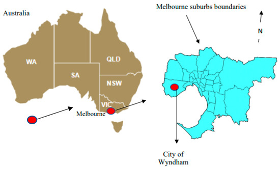
Figure 1.
Location of the WCC in Melbourne and Australia.
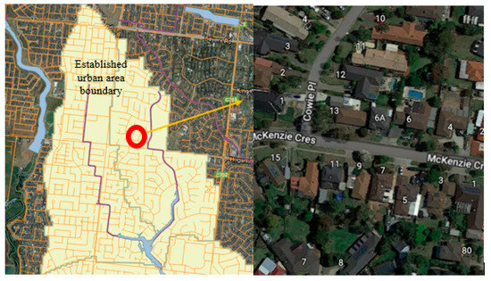
Figure 2.
The boundary of the urban catchment and the density of the households in the area.
3. Research Methodology
A general illustration of the applied methodology for this study is presented in Figure 3. The effectiveness of the WSUD techniques was explored through 5 steps, as detailed in the figure.
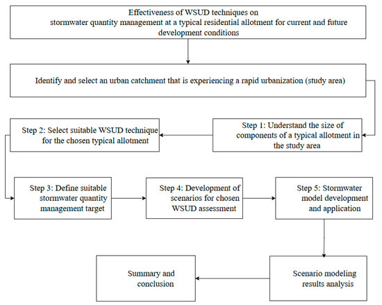
Figure 3.
Steps of the methodology applied in this study.
3.1. Step 1: Understand the Size of Components of a Residential Allotment in the Study Area
Understanding the allotment layout and components in the study area was the first step after choosing a suitable study location in Melbourne and investigating the impact of WSUD techniques at an allotment scale on stormwater runoff and peak flow size. The average size of the components of the allotment was determined based on the available Geographical Information System (GIS) layers and randomly chosen residential properties.
The average allotment size within the study area, as presented in Table 2, encompasses the roof, driveway, other paved surfaces, and garden areas, as illustrated in Figure 4A. According to 2016 census data, the reported average household occupancy in the area ranged from three to five individuals. To model future scenarios and assess the impact of urbanization and population growth, the allotment was subdivided into two townhouses, as depicted in Figure 4B. The average sizes of household components under the future scenario are detailed in Table 2.
Table 2.
Components of a residential allotment in the study area.
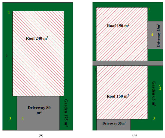
Figure 4.
(A) The allotment component in the study area—current condition. (B) The allotment component—future condition. 1—tank, 2—swale–infiltration trench, 3—rain garden, and 4—permeable pavement.
3.2. Step 2: Select Suitable WSUD Techniques for the Selected Residential Allotment
WSUD techniques offer flexibility and can be implemented at various scales, including catchment-wide applications or specific sites and developments, depending on a project’s requirements and site conditions [42]. These techniques can be applied at the allotment or residential property scale, the street scale within large developments, or integrated at the suburban and case study scales [43]. Table 3 outlines the potentially suitable techniques for implementing WSUD across different development types, along with examples of methods applicable at each scale. Additionally, the possible locations of the selected techniques at an allotment are illustrated in Figure 4A,B.
Table 3.
The potentially suitable WSUD techniques for implementation at different scales.
In this study, based on the most commonly adopted techniques at the allotment scale in Australia, the selected WSUD for scenario modeling included rainwater tanks, rain gardens, permeable pavements, infiltration trenches, and vegetated swales. Following the selection of appropriate techniques, suitable stormwater modeling tools were identified. [44] reviewed 24 decision-support tools for WSUD system design and selection, highlighting that these tools vary in the types of questions they address and their design objectives. They further noted that the differences among these tools are influenced by local conditions.
Considering the study aims as well as the stormwater model’s capabilities, the MUSIC model developed by Water was selected for the stormwater quantity modeling for this study. MUSIC adopts a simplified hydraulic routing approach while supporting the conceptual modeling of a wide range of WSUD techniques. It is the predominant stormwater model used for WSUD assessment in Australia.
MUSIC, developed by eWater, is a robust tool capable of modeling both simple and complex urban stormwater systems that integrate WSUD techniques [45]. It is widely recognized as the preferred stormwater quality modeling tool across much of Australia. MUSIC supports decision-making on WSUD modeling prior to implementation by predicting system performance and assessing its effectiveness in improving stormwater quality and quantity.
Several local fact sheets, guidelines, and procedures have been developed in Australia and other countries to provide appropriate parameter ranges for WSUD techniques [33,46]. In this study, key parameters for the selected WSUD techniques were assigned based on stormwater modeling tool user manuals, existing guidelines, and a comprehensive literature review. The specifications of the selected techniques are detailed in Table 4.
Table 4.
Technique specifications and input values adopted in the MUSIC model [45].
3.3. Step 3: Define Suitable Stormwater Management Target
The primary objective of this study was to assess the reduction in overall stormwater runoff volume and peak flow size resulting from the implementation of various WSUD techniques at the residential allotment scale under different development conditions. Additionally, in Australia, there is a regulatory requirement to reduce the 1.5-year ARI flow to predevelopment levels to support waterway health protection, as outlined in the Best Practice Environmental Management Guidelines: Stormwater [47]. Therefore, the stormwater target was set to achieve the highest reduction percentage for the selected allotment under the future condition to maintain the predevelopment condition. Mean annual flow and peak flow size were used as indicators to be compared for the current and future condition scenario modeling. Reductions were compared for different ARIs.
3.4. Step 4: Development of Scenarios for WSUD Techniques Assessment
Scenarios were developed to evaluate the selected WSUD techniques, both individually and in combination, under current and future development conditions. Initially, the existing residential allotment was considered as the base case. The selected WSUDs were then simulated, and the resulting scenarios were compared against this baseline. To represent future development conditions, the existing dwelling was subdivided into two townhouses, establishing a new future-condition base case. The techniques were again applied, and scenarios were compared against this updated baseline to assess the impact of increased impervious surfaces. The mean annual runoff volume and peak flow size reduction were analyzed using the MUSIC model.
A detailed list of the investigated scenarios for both the current and future development conditions is presented in Table 5.
Table 5.
Investigated scenarios for the selected allotment for current and future conditions.
3.5. Step 5: Stormwater Model Development and Application
The selected residential allotment was represented as a single node within the stormwater model, incorporating pervious and impervious surface ratios. Estimating these ratios is a key parameter in accurately predicting stormwater runoff [48]. Urban areas consist of various surface types, including Directly Connected Areas (DCAs), such as roofs and paved surfaces; Indirectly Connected Areas (ICAs), such as disconnected roofs and gardens; and pervious areas, such as parklands [49]. Based on the distribution of connected, disconnected, and green areas within the selected allotment, the ratios of directly connected impervious surfaces (roofs), pavement, and pervious areas were determined to be 49%, 16%, and 35%, respectively, under current conditions. For the future development scenario, these ratios were adjusted to 60%, 18%, and 21%, respectively.
The stormwater model was developed by incorporating various parameters that represent components of urban catchments. To ensure the reliability of the model’s predictions, a sensitivity analysis was conducted to identify the most influential parameters affecting the model’s outcomes. The analysis determined that soil storage capacity and field capacity were the most critical parameters for the MUSIC model. Initial parameter values were assigned in the models based on a comprehensive literature review and were refined throughout the calibration process. The MUSIC model was calibrated manually, with key soil parameters—including soil storage capacity, field capacity, and conductivity—being initially adopted from the literature and subsequently adjusted during calibration. Rainfall data were sourced from the nearest rainfall station to ensure accuracy. The final adjusted key parameters and their sources for the MUSIC model are presented in Table 6.
Table 6.
Key parameters adjusted for allotment in the MUSIC model.
Another critical parameter for the MUSIC model scenario modeling was the calculation of rainwater tank usage. The current water usage for the allotment was estimated using data from Yarra Valley Water [50], Wyndham City information, and available reports. Assuming an average household size of three people, the total household water consumption was estimated to be approximately 413 L/person/day, accounting for both indoor and outdoor usage. Figure 5 illustrates the typical household water consumption for the study area. For rainwater tank modeling in MUSIC under both current and future development scenarios, two key assumptions were made to allocate the usage demand appropriately.
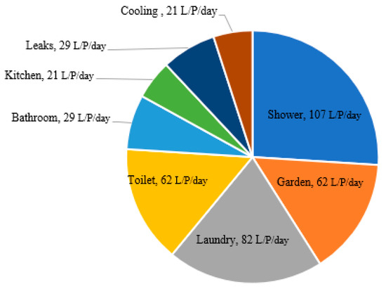
Figure 5.
Typical water usage for existing lots in the study area [51].
- -
- Toilet flushing usage plus laundry and a garden requirement for current household usage for 3 kL and 5 kL tanks were assumed as 206 L/day.
- -
- Toilet flushing usage plus laundry and a garden requirement for future household usage for 3 kL and 5 kL tanks were assumed as 226 L/day by a 10% increase for the future demand.
4. Scenario Modeling Results
Scenarios were simulated and run in the MUSIC model, as explained in Table 5 for selected techniques, individually and in combination. All the investigated scenarios were compared with a benchmark, which was a base case scenario with no WSUD system under current and future development conditions at the allotment. The results were assessed for mean annual flow and peak flow size reduction.
4.1. Mena Annual Flow Reduction
In this study, the reduction in mean annual flow was identified as a critical indicator for stormwater management and was utilized for a comparative analysis of the results. The mean annual flow for the designated allotment was estimated at 112 kL/year under existing conditions and 132 kL/year under projected future development conditions, indicating an increase of at least 17%. This rise is primarily attributed to the greater proportion of impervious surfaces associated with future development. Various scenarios were modeled, and the corresponding results for mean annual flow reduction are illustrated in Figure 6 using the MUSIC model. Among the simulated scenarios, the combination of a 3 kL tank, a rain garden, and an infiltration trench demonstrated the highest percentage reduction in mean annual flow for the selected allotment under both current and future conditions. Conversely, the vegetated swale scenario exhibited the lowest percentage reduction in mean annual flow across both conditions.
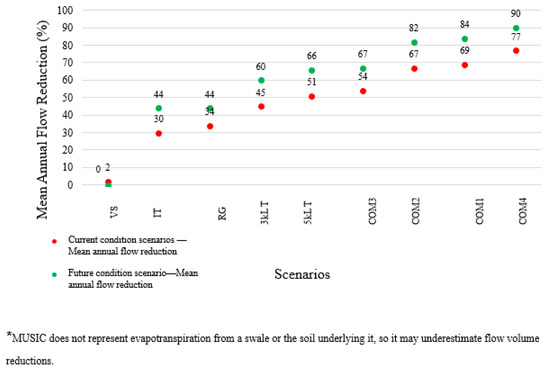
Figure 6.
Mean annual flow reduction percentage for current and future condition scenarios—the MUSIC model.
4.2. Peak Flow Size Reduction in the MUSIC Model
One effective approach to analyzing a catchment’s flood behavior is partial or annual series analysis [49]. The partial series method is more suitable for events with an Annual Exceedance Probability (AEP) of less than 10%, whereas the annual series method is preferred for larger flood events. The partial series analysis technique estimates the empirical relationship between peak magnitudes and the Annual Recurrence Interval (ARI) or the expected number of exceedances per year (EY). In this study, this method was employed to identify independent peak flows exceeding a specified threshold for the selected household within the MUSIC model. Subsequently, an appropriate probability model was fitted to the identified peak values.
Figure 7 and Table 7 present the results of the current condition scenario modeling for the selected Water-Sensitive Urban Design (WSUD) techniques within the MUSIC model. According to the findings, the 3 kL rainwater tank reduced the probability of peak flow exceedance for the household by a minimum of 18% and a maximum of 34%. The 5 kL rainwater tank demonstrated a greater reduction, ranging from 28% to 42%. When household water usage was not considered, both the 3 kL and 5 kL tanks exhibited different behaviors, with varying reduction ranges depending on the event size. Notably, in the absence of household usage, these tanks demonstrated a greater reduction effect for larger flood events. Specifically, the 3 kL tank reduced the probability of peak flow exceedance for events exceeding a five-year recurrence interval by up to 10%, while the 5 kL tank achieved a reduction of up to 18% for the same event category.
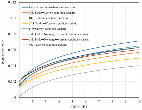
Figure 7.
Fitted probabilities for possible peak flows: scenario comparisons under current conditions and selected techniques.
Table 7.
Range of peak size reduction by each system for the current condition scenario modeling in the MUSIC model.
The modeling of rain gardens resulted in a reduction in peak flow exceedance probability, ranging from 32% to 70% over the simulated period. Similarly, infiltration trenches and vegetated swales exhibited comparable reductions, with minimum reductions of 5% and maximum reductions of 27%.
Overall, the lowest reduction percentages were observed for larger flood events with greater Annual Recurrence Intervals (ARIs). All WSUD techniques were more effective in reducing the probability of peak flow exceedance for smaller events (ARI = 1 to 5 years) compared to larger events (ARI > 5 years). When comparing the effectiveness of individual techniques in reducing peak flow exceedance, the reduction range followed an increasing order: 3 kL tank with no usage, 5 kL tank with no usage, infiltration trench, vegetated swale, 3 kL tank with usage, 5 kL tank with usage, and rain garden, with the latter demonstrating the highest reduction percentage across different rainfall events.
4.2.1. Combination of Techniques Under Current Household Conditions
Figure 8 and Table 8 present the results of the current condition scenario modeling for the combination of a 3 kL rainwater tank with either a rain garden or an infiltration trench in reducing peak flow probability. The findings indicate that both combinations—a 3 kL tank with a rain garden and a 3 kL tank with an infiltration trench—exhibited similar reduction ranges, with minimum reductions of 27% and maximum reductions of 51%.
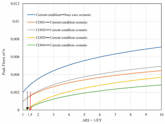
Figure 8.
Fitted probabilities for possible peak flows: scenario comparisons under current conditions and combinations of the selected techniques.
Table 8.
Range of reduction for COM1 to COM4 techniques for current condition scenario modeling.
The highest reduction in peak flow exceedance probability was observed in the COM3 and COM4 scenarios, where the reductions reached up to 100% for very small events (ARI < 1.5 years) and between 50% and 60% for larger events (ARI > 5 years). Furthermore, the combination of all three WSUD techniques effectively maintained peak discharge levels for the 1.5-year ARI event, keeping them close to the predevelopment conditions at the household level under the existing impervious surface ratio.
4.2.2. Individual Techniques Under Future Household Conditions with Dual Occupancy
The results of the future condition scenario modeling, based on the MUSIC model analysis for the selected individual WSUD techniques, are summarized in Figure 9 and Table 9. According to the findings, the implementation of two 3 kL rainwater tanks reduced the probability of peak flow exceedance by a minimum of 30% for larger events and up to 65% for smaller events. In comparison, two 5 kL rainwater tanks demonstrated greater effectiveness, reducing peak flow exceedance probability by an additional 10% to 15% across all event types.
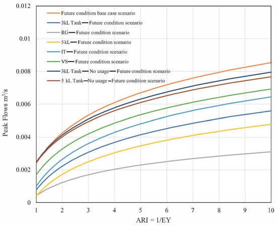
Figure 9.
Fitted probabilities for possible peak flows: scenario comparisons under future conditions and the selected techniques.
Table 9.
Range of peak size reduction by each system for the future condition scenario modeling in the MUSIC model.
Both the 3 kL and 5 kL tanks with no household water usage exhibited different behaviors, showing a varied reduction range depending on the event size. In the absence of usage, these techniques provided a greater reduction for larger flood events. Specifically, two 3 kL tanks reduced the peak flow exceedance probability for events exceeding a five-year recurrence interval by up to 8%, while two 5 kL tanks achieved a reduction of up to 11%. However, under future conditions with an increased impervious surface ratio and no household usage, the effectiveness of rainwater tanks was lower compared to their performance under current conditions.
Additionally, infiltration trenches outperformed vegetated swales in reducing peak flow exceedance probability under future conditions with a higher impervious surface ratio. Rain gardens remained highly effective, reducing peak flow exceedance probability within a range of 57% to 82% over the simulated period.
In summary, similar to the current condition scenarios, lower reduction percentages were observed for larger events with greater Annual Recurrence Intervals (ARIs). All selected WSUD techniques were more effective in reducing the probability of peak flow exceedance for smaller events (ARI = 1 to 5 years) compared to larger events (ARI > 5 years).
When comparing the reduction ranges of individual techniques, the order from least to most effective was as follows: 3 kL tanks with no usage, 5 kL tanks with no usage, infiltration trenches, vegetated swales, 3 kL tanks with usage, 5 kL tanks with usage, and rain gardens. Under future conditions with an increased impervious surface ratio, implementing a combination of two WSUD techniques for townhouses resulted in a greater reduction in peak flow exceedance probability compared to current conditions, demonstrating improved effectiveness in managing stormwater impacts.
4.2.3. Combination of Techniques Under Future Household Conditions
The results of the future condition scenarios are presented in Figure 10 and Table 10. The combination of a 3 kL rainwater tank and a rain garden exhibited a similar reduction range to the combination of a 3 kL tank and an infiltration trench, with reductions ranging from a minimum of 40% to a maximum of 80%. Notably, the maximum reduction range observed in the COM1 and COM2 scenarios under future conditions was 37% higher than that of the same scenarios under current conditions.
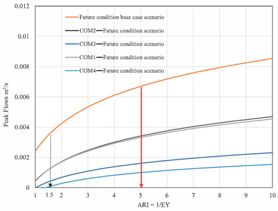
Figure 10.
Fitted probabilities for possible peak flows: scenario comparisons under future conditions and a combination of the selected techniques.
Table 10.
Range of reduction for the combination of techniques for future condition scenario modeling.
Additionally, both combinations demonstrated up to a 35% greater reduction for events with an Annual Recurrence Interval (ARI) greater than five years compared to the same events under current conditions. The highest reduction was observed in the COM3 and COM4 scenarios, where peak flow exceedance probability was reduced by up to 100%. The combination of three WSUD techniques—a rainwater tank, a rain garden, and an infiltration trench—effectively maintained peak discharge levels for the 1.5-year ARI event close to predevelopment conditions, despite the increased impervious surface ratio. Furthermore, significant reductions in peak flows were observed throughout the range, reaching up to 86% for the 1-in-10-year ARI event.
In summary, the MUSIC model results indicate that all selected WSUD techniques effectively reduced the probability of peak flow occurrence for events with an Annual Recurrence Interval (ARI) of 1 year or greater under both the current and future condition scenarios. As future development within the allotment is expected to increase the impervious surface ratio—due to the replacement of the existing property with two townhouses—WSUD techniques are anticipated to play a crucial role in mitigating stormwater peak flows.
However, the performance of rainwater tanks without household usage was less effective under future conditions, demonstrating a lower reduction in peak flow exceedance. This suggests that as the impervious surface ratio increases, the ability of rainwater tanks to attenuate peak flows diminishes, highlighting the need for integrated WSUD strategies to enhance stormwater management effectiveness in highly developed areas.
4.3. Mean Annual Flow Reduction and Peak Flow Reduction in the PCSWMM Model
Research on allotment-scale studies and the effectiveness of WSUD techniques in managing stormwater quantity is either scarce or has not been conducted. However, to verify that the MUSIC model did not overestimate or underestimate reduction percentages, the scenarios presented in Table 5 were simulated using the PCSWMM model to compare the range of results with those from the MUSIC model. SWMM was first developed by the USA Environmental Protection Agency (USEPA) in 1971 and has been accepted and used across the world as a tool for hydrological and hydraulic processes modeling of a catchment. The PCSWMM model, which is a combination of SWMM 5 and a Geographical Information System (GIS), can provide a complete package for 1D and 2D rainfall–runoff process analysis. In addition, PCSWMM can model stormwater source control technologies to manage stormwater quality and quantity [52]. Table 11 outlines the key parameters adopted in the PCSWMM model. Also, no usage was assumed for rainwater tanks in the PCSWMM model for the combination scenarios.
Table 11.
Asset specifications and input values adopted for the PCSWMM model [52,53].
Similar to the MUSIC model results, the highest reduction percentage for the mean annual flow at the selected allotment was achieved by a combination of a 3 kL tank, a rain garden, and an infiltration trench under both current and future conditions in the PCSWMM model. However, the lowest reduction percentage was achieved with 3 kL and 5 kL rainwater tanks and no usage. In Figure 11, the MUSIC model results confirmed the low reduction range of the mean annual flow as the PCSWMM model results for rainwater tanks and no usage.
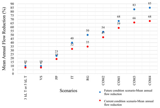
Figure 11.
Mean annual flow reduction percentage for the current and future condition scenarios—PCSWMM model.
Using the PCSWMM model and the chosen WSUD in the allotment, it was found that vegetated swales were the least effective systems in reducing the peak size for both current and future allotment conditions. At the same time, a combination of a 3 kL tank, a rain garden, and an infiltration trench showed the most reduced peak size under both current and future allotment conditions. The results are summarized in Figure 12.
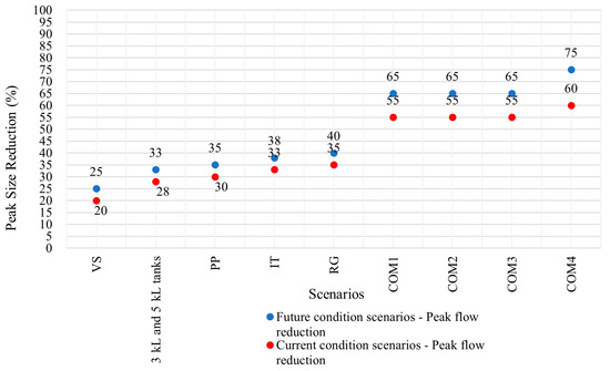
Figure 12.
Peak size reduction in the PCSWMM model: scenario comparisons for current and future conditions.
According to the results of this study, it was found that the reduction percentage of the peak size and mean annual runoff volume were similar for the selected WSUD assets in both modeling tools: MUSIC and PCSWMM. Vegetated swales showed the least reduction, and the combination of three systems showed the most reduction in the peak size and mean annual runoff in both modeling tools.
5. Scenario Comparison Using Life Cycle Cost (LCC) Analysis
The considered scenarios were simulated for the selected allotment, revealing that while vegetated swales and rainwater tanks without reuse were relatively less effective, all other selected WSUD systems successfully reduced the mean annual runoff volume and peak flow under both existing and future development conditions with a higher impervious fraction. However, the Life Cycle Cost (LCC) of these systems poses a potential barrier to their implementation.
An LCC analysis was conducted using the MUSIC model for the evaluated scenarios, applying a 5% discount rate over a 50-year period. Life cycle costing is defined as the process of determining the total cost of a product or project, encompassing acquisition, installation, operation, maintenance, refurbishment, and disposal expenses [54]. LCC analysis is a crucial factor in selecting optimal stormwater management systems, particularly when multiple options must be evaluated [55]. Figure 13 presents the LCC results for each scenario considered in this study. The analysis ranked the scenarios from least to most costly in terms of implementation at the selected allotment.
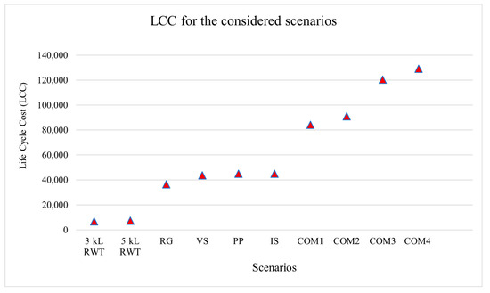
Figure 13.
LCC analysis for the considered WSUD techniques.
When considering the LCC for system implementation, rainwater tanks emerged as the most cost-effective solution for managing urban stormwater volume and peak flows at the allotment scale. This suggests that as urban development continues to accelerate, rainwater tanks may provide the most practical and financially viable option for stormwater management in rapidly growing urban areas.
6. Conclusions
This study investigated the reduction in the stormwater runoff mean annual volume and peak flow size for a residential allotment undergoing redevelopment, transitioning from a single dwelling to two dwellings in the future. Under the “future” condition, the impervious surface ratio of the allotment increased due to the replacement of a single dwelling with multiple units. The selected residential allotment was located within an urban catchment in West Melbourne.
Five Water-Sensitive Urban Design (WSUD) techniques—rainwater tanks, infiltration trenches, rain gardens, and vegetated swales—were chosen for the scenarios. The results indicated that while all WSUD techniques contributed to stormwater management, vegetated swales and rainwater tanks without reuse were less effective in reducing the mean annual runoff volume and peak flow size compared to the other selected systems. This was observed under both existing and future development conditions, particularly with a greater impervious fraction.
Peak flow rates for storm events with a 1-in-5-year Annual Recurrence Interval (ARI), which aligns with the typical design standard for piped drainage systems, were reduced by 90% under the future redeveloped condition. Additionally, smaller events up to a 1-in-1-year ARI were largely eliminated, thereby reducing the frequency of runoff discharges that could disturb waterways. The combination of three WSUD techniques—a rainwater tank, a rain garden, and an infiltration trench—effectively maintained peak discharge for the 1.5-year ARI event near predevelopment levels at the household scale under future development conditions.
Significant reductions in peak flows were observed across various storm events, with up to an 86% reduction for events with a 1-in-10-year ARI. Furthermore, the total mean annual runoff volume was reduced by up to 90% when all three WSUD techniques were implemented under future development conditions. While they had the highest costs, the combination of a rainwater tank, rain garden, and infiltration trench provided the most reduction in the stormwater runoff volume and peak flow size when undertaking the MUSIC and PCSWMM modeling tools. The reduction percentage in the peak size and mean annual runoff volume were similar for the selected WSUD assets when using both modeling tools, MUSIC and PCSWMM.
An LCC analysis using the MUSIC model was conducted to rank the considered scenarios based on cost-effectiveness. The ranking categorized the scenarios from the least to the most costly for implementation at the selected allotment. This study confirmed that the chosen WSUD techniques were highly effective in mitigating the impacts of urbanization, reducing urban flooding risks, and preserving waterway health at the residential allotment scale. The high reduction percentages in the peak flow and runoff volume indicate that these systems can maintain predevelopment conditions even under future redevelopment scenarios. However, the LCC and ongoing maintenance requirements should be considered critical factors for the successful implementation of these systems at a residential scale.
In conclusion, it is suggested that to enhance the effectiveness of WSUD techniques, long-term field studies should be conducted at different scales to assess performance across diverse climatic and urban conditions. Integrating AI-driven hydrological models and smart monitoring can improve system efficiency. Additionally, standardized regulations and incentive mechanisms should be developed to promote widespread adoption, specifically at allotment scales. Public engagement is also crucial—raising awareness and encouraging community participation can support sustainable stormwater management efforts.
Author Contributions
Conceptualization, S.R., A.K.S., D.B. and A.R.L.; methodology, S.R., A.K.S., D.B. and A.R.L.; software, S.R.; validation, S.R.; formal analysis S.R.; investigation, S.R.; resources, S.R., A.K.S., D.B. and A.R.L.; data curation, S.R.; writing—original draft preparation, S.R.; writing—review and editing,. S.R., A.K.S., D.B., A.R.L. and E.Y.; visualization, S.R.; supervision, A.K.S., D.B., A.R.L. and E.Y.; project administration, S.R.; funding acquisition, Melbourne Water and Water Research Australia. All authors have read and agreed to the published version of the manuscript.
Funding
The authors declare that this study received funding from Melbourne Water through Water Research Australia Limited. The funder had the following involvement with the study: Data collection for models’ calibration.
Data Availability Statement
All the data utilized in this study is available in the references cited throughout the article.
Acknowledgments
The author would like to thank Victoria University, Melbourne Water, and Water Research Australia Limited for their support of this project.
Conflicts of Interest
Author Dale Browne was employed by the company E2DESIGNLAB. The remaining authors declare that the research was conducted in the absence of any commercial or financial relationships that could be construed as a potential conflict of interest.
Appendix A
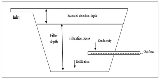
Figure A1.
Schematic diagram of a rain garden.
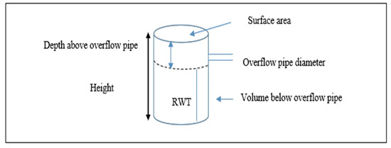
Figure A2.
Schematic diagram of a rainwater tank.
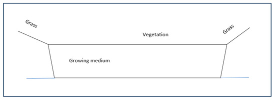
Figure A3.
Schematic diagram of a swale.
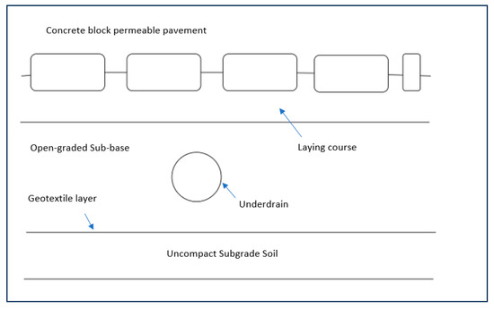
Figure A4.
Schematic diagram of a permeable pavement.
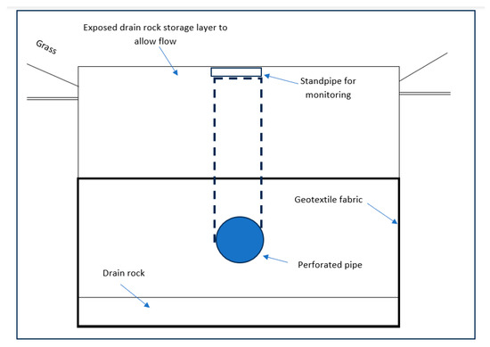
Figure A5.
Schematic diagram of an infiltration trench.
References
- Zhang, Y.; Grant, A.; Sharma, A.; Chen, D.; Chen, L. Alternative water resources for rural residential development in Western Australia. Water Resour. Manag. 2010, 24, 25–36. [Google Scholar]
- Ahammed, F. A review of water sensitive urban design technologies and practices for sustainable stormwater management. Sustain. Water Resour. Manag. 2017, 3, 269–282. [Google Scholar]
- Akhter, M.S.; Hewa, G.A. The use of PCSWMM for assessing the impacts of land use changes on hydrological responses and performance of WSUD in managing the impacts at Myponga catchment, South Australia. Water 2016, 8, 511. [Google Scholar] [CrossRef]
- Ladson, A.R. Using WSUD to restore predevelopment hydrology. In Approaches to Water Sensitive Urban Design; Sharma, A., Gardner, T., Begbie, D., Eds.; Chapter 10; Elsevier: Amsterdam, The Netherlands, 2019. [Google Scholar]
- Trudeau, M.P.; Richardson, M. Change in event-scale hydrologic response in two urbanising watersheds of the Great Lakes St Lawrence Basin 1969–2010. J. Hydrol. 2015, 523, 650–662. [Google Scholar]
- Duncan, H.P.; Fletcher, T.D.; Vietz, G. The Feasibility of Maintaining Ecologically and Geomorphically Important Elements of the Natural Flow Regime in the Context of a Superabundance of Flow: Stage 1—Kororoit Creek Study Hugh; Melbourne Waterway Research-Practice Partnership: Melbourne, Australia, 2014. [Google Scholar]
- Fletcher, T.D.; Vietz, G.; Walsh, C.J. Protection of stream ecosystems from urban stormwater runoff: The multiple benefits of an ecohydrological approach. SAGE J. 2014, 38, 543–555. [Google Scholar]
- Rashetnia, S.; Sharma, A.K.; Ladson, A.R.; Browne, D.; Yaghoubi, E. A scoping review on Water Sensitive Urban Design aims and achievements. Urban Water J. 2022, 19, 453–467. [Google Scholar]
- Whelans, C.; Halpern, G.M.; Thompson, P. Policy Planning and Management Guidelines for Water Sensitive Urban (Residential) Design; Whelans: Perth, Australia, 1994. [Google Scholar]
- Benedict, M.; McMahon, E. Green Infrastructure Linking Landscapes and Communities; Island Press: Washington, DC, USA, 2006. [Google Scholar]
- Fletcher, D.T.; William, S.; Hunt, W.F.; Richard, A.; Butler, D.; Arthur, S.; Trowsdale, S.; Barraud, S.; Semadeni-Davies, A.; Bertrand-Krajewski, J.; et al. SUDS, LID, BMPs, WSUD and more—The evolution and application of terminology surrounding urban drainage. Urban Water J. 2015, 12, 525–542. [Google Scholar] [CrossRef]
- Jia, H.; Wang, Z.; Zhen, X.; Clar, M. The sponge city program and its implications for urban stormwater management. Sustain. Cities Soc. 2020, 55, 102066. [Google Scholar]
- Qiao, X.; Kristoffersson, A.; Randrup, T.B. A review of green infrastructure for stormwater management in cities. Water 2019, 11, 393. [Google Scholar]
- Gonçalves ML, R.; Zischg, J.; Rau, S.; Sitzmann, M.; Rauch, W.; Kleidorfer, M. Modelling the effects of introducing low impact development in a tropical city: A case study from Joinville, Brazil. Sustainability 2018, 10, 728. [Google Scholar] [CrossRef]
- Lloyd, S.D.; Wong, T.H.F.; Chesterfield, C.J. Water Sensitive Urban Design—A Stormwater Management Perspective (Industry Report No. 02/10); Cooperative Research Centre for Catchment Hydrology: Melbourne, Australia, 2002. [Google Scholar]
- Lloyd, S.D. Water Sensitive Urban Design in the Australian Context, Synthesis of a Conference Held 30–31 August 2000, Melbourne, Australia; Cooperative Research Centre for Catchment Hydrology: Clayton, Australia, 2001. [Google Scholar]
- Stagge, J.H.; Davis, A.P.; Jamil, E.; Kim, H. Performance of grass swales for improving water quality from highway runoff. Water Resour. 2012, 20, 6731–6742. [Google Scholar] [CrossRef] [PubMed]
- Trowsdale, S.A.; Simcock, R. Urban stormwater treatment using bioretention. J. Hydrol. 2011, 397, 167–174. [Google Scholar] [CrossRef]
- Yang, H.; Florence, D.C.; McCoy, E.L.; Dick, W.A.; Grewal, P.S. Design and hydraulic characteristics of a field scale bi-phasic bioretention raingarden system for stormwater management. Water Sci. Technol. 2009, 59, 1863–1872. [Google Scholar] [CrossRef]
- Davis, A.P.; Hunt, W.F.; Traver, R.G.; Clar, M. Performance of bioretention systems in urban stormwater management: A review. Water Environ. Res. 2020, 92, 1071–1082. [Google Scholar]
- Hatt, B.E.; Fletcher, T.D.; Deletic, A. Hydrologic and pollutant removal performance of stormwater biofiltration systems at the field scale. J. Hydrol. 2009, 365, 310–321. [Google Scholar] [CrossRef]
- Lucke, T.; Nicholas, P. The pollution removal and stormwater reduction performance of street-side bioretention basins after ten years in operation. Sci. Total Environ. 2015, 536, 784–792. [Google Scholar] [CrossRef]
- Hoban, A.T. Facing the MUSIC: A review of bioretention performance. In Proceedings of the 2017 Joint IECA National Conference and Stormwater Queensland Conference, Brisbane, Australia, 11–12 October 2017. [Google Scholar]
- Ackerman, D.; Stein, E.D. Evaluating the effectiveness of best management practices using dynamic modelling. J. Environ. Eng. 2008, 134, 628–663. [Google Scholar] [CrossRef]
- Barrett, M.E. Performance comparison of structural stormwater best management practice. Water Environ. Res. 2005, 77, 78–86. [Google Scholar] [CrossRef]
- Gomes UA, F.; Heller, L.; Pena, J.L. A national program for large scale rainwater harvesting: An individual or public responsibility? Water Resour. Manag. 2012, 26, 2703–2714. [Google Scholar] [CrossRef]
- Fewkes, A. A review of rainwater harvesting in the UK. Struct. Surv. 2012, 30, 174–194. [Google Scholar] [CrossRef]
- Ward, S.; Memon, F.A.; Butler, D. Rainwater Harvesting: Model-based design evaluation. Water Sci. Technol. 2010, 61, 85–96. [Google Scholar] [CrossRef]
- Australian Bureau of Statics (ABS). Available online: http://www.abs.gov.au/AUSSTATS/abs@.nsf/DetailsPage/4602.0.55.003Mar%202010? (accessed on 20 August 2018).
- Yazdi, S.K.; Scholz, M. Combined bio-filtration, water detention and infiltration system treating road runoff. In Proceedings of the 10th British Hydrological Symposium, Oxford, UK, 15–17 September 2008; pp. 353–358. [Google Scholar]
- Walsh, C.J.; Pomeroy, C.A.; Burian, S.J. Hydrologic Modelling Analysis of a Passive, Residential Rainwater Harvesting Program in an Urbanized, Semi-Arid Watershed. J. Hydrol. 2014, 508, 240–253. [Google Scholar]
- Campisano, A.; Modica, C. Optimal sizing of storage tanks for domestic rainwater harvesting in Sicily (Italy). Water 2014, 6, 2332–2347. [Google Scholar]
- Argue, R.J. WSUD: Basic Procedures for ‘Source Control’ of Stormwater—A Handbook for Australian Practice; The University of South Australia: Adelaide, Australia, 2013. [Google Scholar]
- Beecham, S.; Pezzaniti, D.; Kandasamy, J. Stormwater treatments using permeable pavements. Water Manag. 2012, 165, 161–170. [Google Scholar]
- Freni, G.; Mannina, G.; Viviani, G. Urban stormwater quality management: Centralised versus source control. J. Water Resour. Plan. Manag. 2010, 136, 268–278. [Google Scholar] [CrossRef]
- Ullate, E.G.; Lopez, E.C.; Fresno, D.C.; Bayon, J.R. Analysis and contrast of different pervious pavements for management of stormwater in parking area in Northern Spain. Water Resour. Manag. 2011, 25, 1525–1535. [Google Scholar]
- Bean, E.Z.; Hunt, W.F.; Bidelspach, D.A. Field survey of permeable pavement surface infiltration rates. J. Irrig. Drain. Eng. 2007, 133, 249–255. [Google Scholar]
- Kuang, X.; Sansalone, J.; Ying, G.; Ranieri, V. Pore-structure models of hydraulic conductivity for porous pavement. J. Hydrol. 2011, 399, 148–157. [Google Scholar] [CrossRef]
- Hsieh, P.C.; Chen, Y.C. Surface water flow over a pervious pavement. Int. J. Numer. Anal Methods Geo-Mech. 2012, 37, 1095–1105. [Google Scholar]
- Lucke, T.; Beecham, S. Field investigation of clogging in a permeable pavement system. Build. Res. Inf. 2011, 39, 603–615. [Google Scholar]
- Siriwardene, N.R.; Deletic, A.; Fletcher, T.D. Clogging of stormwater gravel infiltration systems and filters: Insights from a laboratory study. Water Resour. 2007, 41, 1433–1440. [Google Scholar]
- Myers, B.; Chacko, P.; Tjandraatmadja, G.; Cook, S.; Umapathi, S.; Pezzanitti, D.; Sharma, A.K. The Status of Water Sensitive Urban Design in South Australia; Goyder Institute for Water Research Technical Report Series No. 13/11; Goyder Institute for Water Research: Adelaide, South Australia, 2013. [Google Scholar]
- Department of Planning and Local Government. Water Sensitive Urban Design Technical Manual for the Greater Adelaide Region; Government of South Australia: Adelaide, Australia, 2010. [Google Scholar]
- Lerer, S.M.; Arnbjerg-nielsen, K.; Mikkelsen, P.S. A Mapping of Tools for Informing Water Sensitive Urban Design Planning Decisions—Questions. Asp. Context Sensit. 2015, 7, 993–1012. [Google Scholar]
- MUSIC Guidelines. Input Parameters and Modelling Approaches for MUSIC Users in Melbourne Water’s Service Area. 2018. Available online: https://www.clearwatervic.com.au/user-data/private-storage-files/melbourne_water_music_guidelines_update_draft_jan-2016.pdf (accessed on 17 March 2025).
- Melbourne Water. Stormwater Strategy; Melbourne Water: Melbourne, Australia, 2013. [Google Scholar]
- The Best Practice Environmental Management Guidelines: Stormwater; Victoria Stormwater Committee: Wangaratta, VIC, Australia, 1999.
- Alley, W.M.; Veenhuis, J.E. Effective impervious area in urban runoff modelling. J. Hydraul. Eng. 1983, 109, 313–319. [Google Scholar]
- Ball, J.E.; Powell, M. Inference of catchment modelling system control parameters. In Proceedings of the UDM ’98: Developments in Urban Drainage Modelling, London, UK, 21–24 September 1998; Volume 1, pp. 313–320. [Google Scholar]
- Ghobadi, C.; Athuraliya, A.; Gan, K.; Jones, C.; Nelson, L.; Quillam, M.; Redhead, M.; Siriwardene, N. Water Appliance Stock Survey and Usage Pattern Melbourne 2012; Smart Water Fund: Melbourne, Australia, 2013. [Google Scholar]
- Wyndham City Council. Water Needs Information; Dalton Consultant Engineers Pty Ltd.: Melbourne, Australia, 2018. [Google Scholar]
- James, W.; Rossman, L.A.; James, W.R.C. User’s Guide to SWMM 5, 13th ed.; Computational Hydraulics International (CHI): Guelph, ON, Canada, 2010. [Google Scholar]
- Rossman, L. Storm Water Management Model User’s Manual Version 5.1—Manual; EPA/600/R-14/413 (NTIS EPA/600/R-14/413b); US EPA Office of Research and Development: Washington, DC, USA, 2015. [Google Scholar]
- Standards Australia. AS/NZS 4536:1999 Life Cycle Costing An Application Guide; Standards Australia: Homebush, NSW, Australia, 1999. [Google Scholar]
- Taylor, A. Structural Stormwater Quality BMP Cost/Size Relationship Information from the Literature; Cooperative Research Centre for Catchment Hydrology: Melbourne, Australia, 2005; pp. 53–64. [Google Scholar]
Disclaimer/Publisher’s Note: The statements, opinions and data contained in all publications are solely those of the individual author(s) and contributor(s) and not of MDPI and/or the editor(s). MDPI and/or the editor(s) disclaim responsibility for any injury to people or property resulting from any ideas, methods, instructions or products referred to in the content. |
© 2025 by the authors. Licensee MDPI, Basel, Switzerland. This article is an open access article distributed under the terms and conditions of the Creative Commons Attribution (CC BY) license (https://creativecommons.org/licenses/by/4.0/).