Abstract
Mining-induced subsidence has significantly altered the structure of the vadose zone in coal mining areas, where soil cracks act as preferential pathways controlling water infiltration and redistribution. In this study, a Hydrus-2D dual-domain seepage model incorporating geometric parameterization of cracks was developed to simulate water migration in the vadose zone of a typical subsidence area in the Ordos Basin. The model integrates field-measured crack geometry, soil texture, and rainfall characteristics to quantitatively analyze preferential flow formation under twelve combinations of crack width, soil type, and rainfall intensity. The results show that (i) crack width dominates preferential flow behavior, with wider cracks (≥5 cm) deepening the wetting front from approximately 107 cm to 144 cm within 120 h and sustaining high conductivity after rainfall; (ii) soil texture governs infiltration pathways, as sandy soils promote deeper wetting fronts (up to 99 cm, ~40% deeper than loam) and layered soils induce interface retention or “jump” infiltration; and (iii) rainfall intensity controls infiltration depth, with storm events producing wetting fronts more than four times deeper than those under light rain. Overall, this study demonstrates the feasibility and significance of integrating crack parameterization into vadose-zone hydrological modeling using Hydrus-2D, providing a quantitative basis for understanding rapid infiltration–migration–recharge processes and supporting ecological restoration and water resource management in arid and semi-arid mining regions.
1. Introduction
Typical mining areas in northern China are not only important national energy bases but also located in arid and semi-arid regions that are ecologically fragile []. The environmental security of these regions is closely linked to the stability of local ecosystems and the distribution of water resources []. However, long-term, high-intensity coal mining activities have caused significant ecological disturbances, manifested in vegetation degradation, soil erosion, surface subsidence, and the widespread development of soil cracks. These disruptions to the land surface and soil structure fundamentally reshape soil–moisture–atmosphere interactions in the vadose zone, altering regional water cycles and threatening ecosystem stability [,,]. In arid and semi-arid climatic zones, preferential flow is a common phenomenon due to the dry, loose surface soil structure and frequent formation of tension cracks. These cracks create preferential pathways for rapid rainfall infiltration and water redistribution [,,]. Preferential flow refers to the process by which rainfall or irrigation water bypasses the soil matrix’s pore space and rapidly infiltrates along cracks or other macropores [,]. This significantly alters infiltration rates, the morphology of wetting fronts, and patterns of deep soil recharge []. The process not only influences groundwater recharge and surface runoff conversion but also directly affects solute transport, nutrient movement, and pollutant leaching, thus having profound implications for regional water resource management and ecological restoration []. These cracks not only determine the pathways of groundwater recharge and surface runoff transformation but also play a critical role in ecological recovery and the sustainable management of water resources [,].
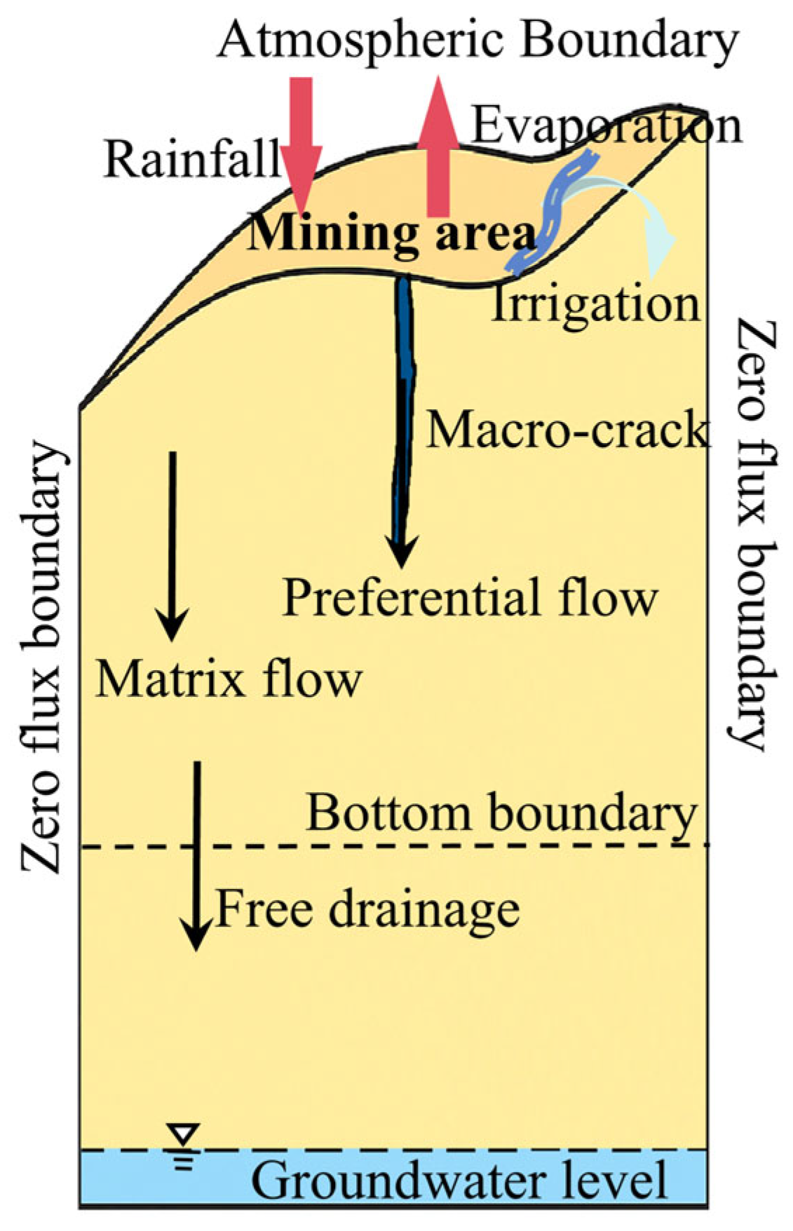
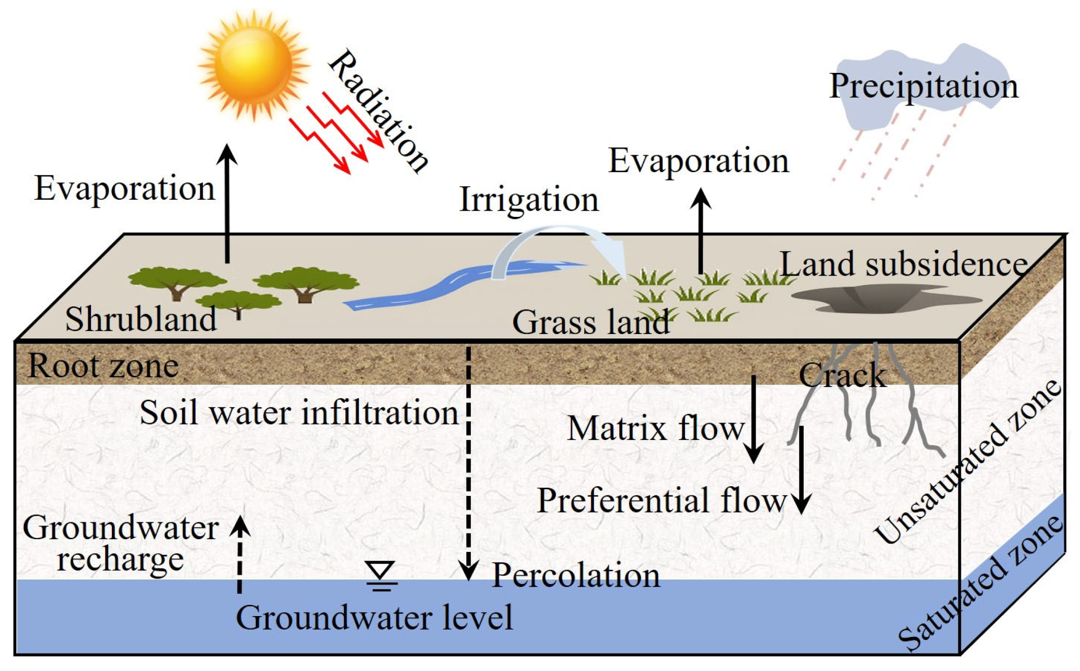
The vadose zone is a critical transitional layer between the land surface and the groundwater table, and its hydrodynamic processes directly control vertical water and solute transport (Figure 1) [,,]. These processes are influenced by multiple factors, including initial soil moisture content, rainfall intensity, and crack geometry (e.g., width, depth, and number) []. Among these, cracks—typical macropore structures that often develop due to dry–wet cycles or mining disturbances—significantly increase the heterogeneity of water movement. Water can bypass the soil matrix pores and infiltrate rapidly along cracks, resulting in a distinct preferential flow phenomenon [,,]. Traditional one-dimensional seepage models struggle to accurately describe this complex behavior. In contrast, dual-domain seepage models more effectively capture the mechanisms of water movement dominated by preferential flow by coupling matrix flow with crack flow [,]. At a finer scale, soil water transport is also strongly influenced by the micro- and nano-scale heterogeneity of pore structures. Recent studies have shown that the connectivity, fractal characteristics, and transformation of nanoscale pores play a crucial role in determining the hydraulic and capillary behavior of geomaterials. For example, investigations into the fractal pore structure of Longmaxi Shales revealed scale-dependent heterogeneity and non-linear flow properties [], while nanostructure transformation under mechanical deformation provides new insights into fluid migration pathways []. These findings highlight that the multi-scale coupling—from nano-pore networks to visible macroscopic cracks—collectively governs the water transport behavior in complex porous media, offering a theoretical foundation for understanding preferential flow in cracked vadose zones. In recent years, Hydrus-2D/3D has become a widely used numerical model for investigating water transport in unsaturated soils []. For example, Song et al. [] employed Hydrus-2D to analyze how the morphological characteristics of mining-induced ground fissures influence the spatiotemporal distribution of soil moisture, highlighting preferential flow along surface cracks. Li et al. [] integrated in situ monitoring with Hydrus-2D simulations to characterize soil moisture transport in coal mining subsidence areas and demonstrated that crack development accelerates vertical infiltration. Bai et al. [] further revealed, through Hydrus-based modeling and field observations, that mining subsidence significantly alters the spatial variability of soil moisture and infiltration patterns. Collectively, these studies confirm the reliability and practicality of Hydrus-2D/3D for simulating water movement in cracks mining terrains and provide a theoretical foundation for exploring the mechanisms of soil water migration in response to mining-induced subsidence cracks [,]. The Hydrus model not only enables the simultaneous construction of a dual-domain structure—including both matrix and macropore domains—but also effectively captures the exchange processes between crack flow and the soil matrix []. Although Hydrus has been extensively applied in fields such as agricultural irrigation and slope hydrology, its use in vadose zone environments of mining areas remains limited []. In particular, there is a lack of systematic evaluation of how crack geometry (e.g., shape, size, and distribution) influences water migration behavior under varying hydrological conditions.
Figure 1.
Conceptual model of hydrological processes in the mining areas.
Based on this, the present study focuses on a typical coal mining crack area in the Ordos Basin. It integrates field-measured soil moisture characteristic curves and crack geometric parameters to construct a dual-domain seepage model using Hydrus-2D. By designing simulation scenarios with varying initial soil moisture content, rainfall intensity, and crack parameters (number and width), the study systematically analyzes the water migration process in the unsaturated zone and explores the regulatory role of crack structures in vertical seepage pathways. The results offer a new perspective for understanding heterogeneous hydrological processes in mining-affected areas and provide theoretical support and technical references for regional ecological restoration and efficient water resource management. The inclusion of pore-scale heterogeneity and fractal conceptualization provides a bridge between microscopic soil structure and macroscopic hydrological response, offering a more comprehensive understanding of multi-scale water migration mechanisms.
2. Materials and Methods
2.1. Study Area
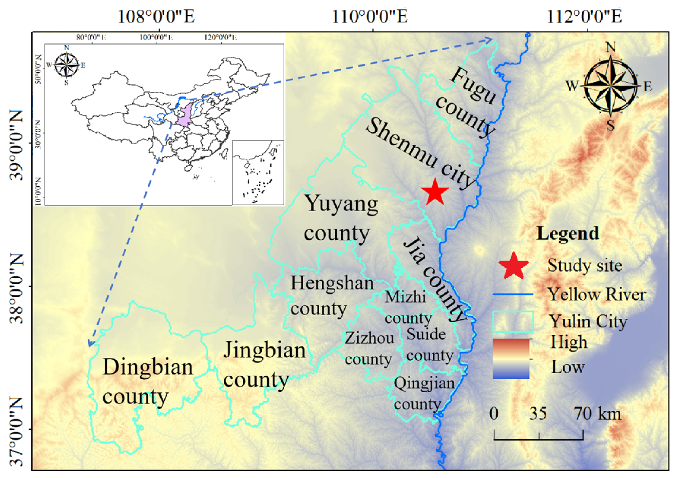
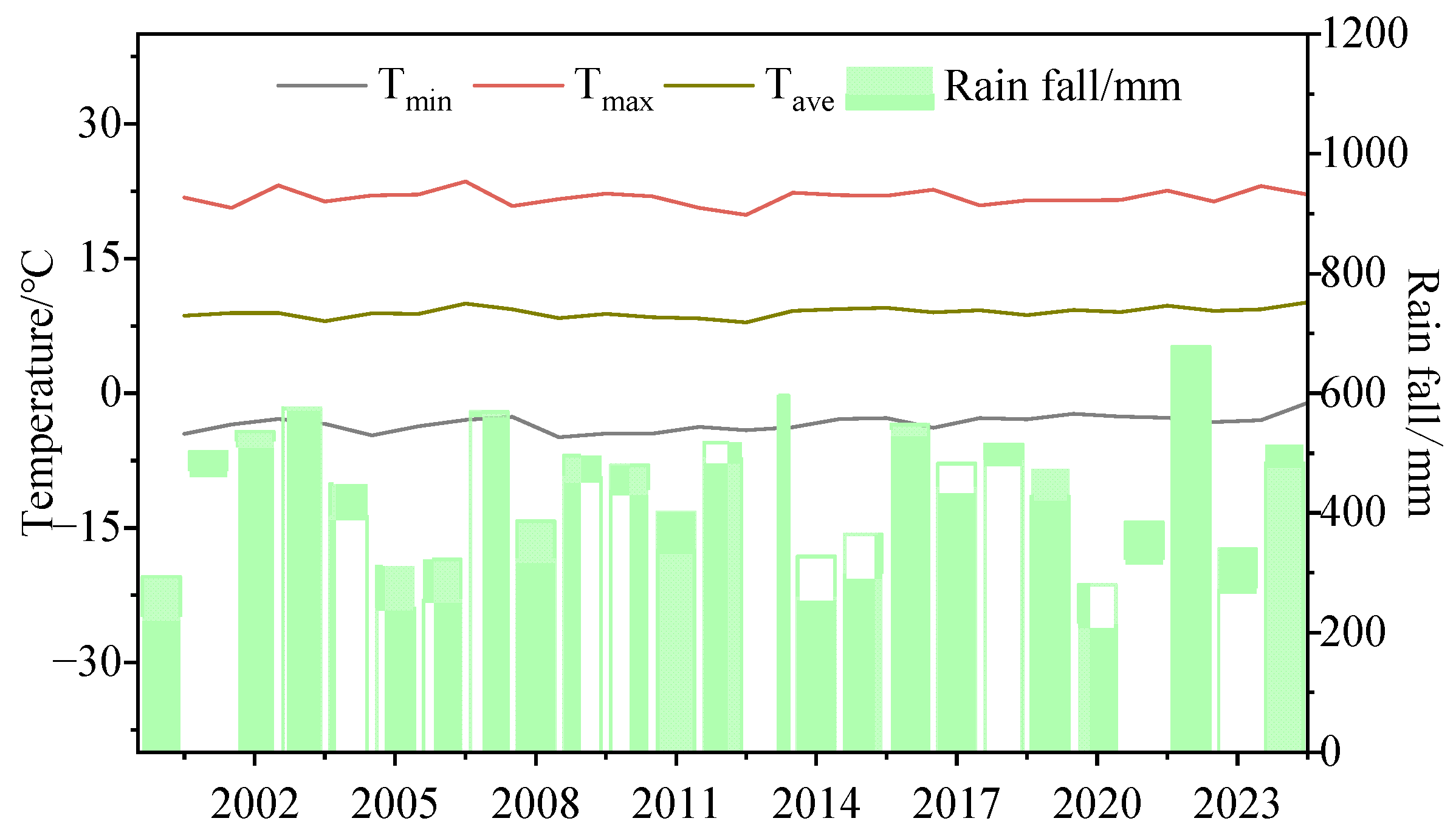
The study area is located in Shenmu City (36°57′–39°34′ N, 107°28′–111°15′ E), Yulin City, Shaanxi Province, on the northern margin of the Ordos Basin (Figure 2). It is a typical resource-based energy city and one of China’s major national coal production bases. The region lies within an ecologically fragile zone characterized by an arid to semi-arid continental monsoon climate, forming the natural background for the subsequent hydrological and ecological analyses. The superimposition of intense energy exploitation and high ecological sensitivity makes this region an ideal case study for examining mining-induced cracks and regional hydrological and ecological processes [,,]. The area experiences an average annual temperature of 8–9 °C and annual precipitation of 350–450 mm, approximately 75% of which occurs from June to September. In contrast, annual evaporation is extremely high (1700–1800 mm). Long-term meteorological records indicate significant interannual variability and an increasing frequency of extreme rainfall events, although the overall annual precipitation shows a slight declining trend (Figure 3) [,]. These climatic characteristics reflect strong seasonal concentration and periodic variation in rainfall, directly influencing crack formation and hydrological processes in the region. The main rivers in the study area include the Yellow River, Kuye River, and Tuwei River, which exhibit marked seasonal flow variations and high sediment loads. However, long-term intensive coal mining has caused a continuous decline in the groundwater table, exceeding 60 m in some mined-out areas, thereby weakening the hydraulic connection between the unsaturated and saturated zones []. The formation and expansion of mining-induced cracks in the vadose zone provide preferential flow paths for rainfall infiltration, altering the vertical soil-moisture distribution and the regional infiltration regime.
Figure 2.
Location layout of the study site.
Figure 3.
Meteorological Data of Shenmu City, Yulin City, 2000~2024.
Through field investigations and sampling, it was found that the near-surface soil mainly consists of sandy soil, silty soil, sandy loam, and loam. Among these, loam and sandy soil were selected as the main materials for simulation analysis because their contrasting textures and hydraulic properties allow for a clearer evaluation of the influence of soil texture on infiltration behavior. The development of subsidence-induced cracks is closely linked to soil mechanical and hydraulic properties. In the Shenmu mining area, these cracks are typically vertical or subvertical, with widths ranging from several millimeters to several centimeters and depths generally between 1 and 2 m. They are predominantly tensile cracks formed under differential settlement during mining subsidence and act as preferential flow pathways that enhance vertical infiltration.
2.2. Model Establishment
2.2.1. Mathematical Equations
The Hydrus-2D model is a physically based, finite-element simulation tool that solves the governing equations of water, heat, and solute movement in variably saturated porous media. It is founded on the Richards equation, which describes transient unsaturated flow derived from Darcy’s law and the continuity equation. In Hydrus-2D, this equation is extended to two-dimensional and axisymmetric domains to represent the coupled vertical and lateral movement of soil water under natural and anthropogenic influences. The model allows for the definition of dual-permeability or dual-porosity domains, in which the soil matrix and macropore regions interact through water exchange governed by pressure head gradients. This structure enables accurate simulation of preferential flow, especially in fractured or cracked soil, where conventional single-domain models often underestimate infiltration rates. The van Genuchten–Mualem equations describe the relationship between soil water content, suction head, and hydraulic conductivity, providing a continuous representation of hydraulic properties over the full saturation range. These nonlinear relationships capture the unique capillary behavior and anisotropy soil. Numerically, Hydrus-2D discretizes the flow domain into triangular finite elements and employs an iterative solution scheme to achieve mass-conservative results. The model supports both steady-state and transient boundary conditions, including atmospheric, seepage, and free drainage boundaries.
In this study, a two-dimensional water transfer process is considered to represent soil water flow through the vadose zone with cracks. The governing equation is derived from the classical Richards equation and adapted to include horizontal and vertical flow components as well as a sink term for root water uptake, as shown below []:
where θ is volumetric water content, [L3 L−3], t is time (T), h is head [L], K(h) is unsaturated hydraulic conductivity function [L T−1], x and z are spatial coordinates (L), and S (x, z, h) is the sink term, representing root water uptake [T−1].
The soil water retention curve and hydraulic conductivity function are described using the van Genuchten–Mualem model [,]:
where θr and θs are the residual and saturated volumetric water contents [L3 L−3], α [L−1], n and m are empirical shape parameters, l is the pore-connectivity parameter, typically set to 0.5 for most soils, and Ks [L T−1] is the saturated permeability coefficient. Soil hydraulic parameters used in the van Genuchten–Mualem model (θs, θr, α, n, and Ks) were determined through a combination of field investigation, laboratory testing, and model-based parameter inversion. The soil type and physical properties of were first identified based on field sampling and laboratory measurements, which are utilized for determining the parameters using the neural network method of the Hydrus model []. Meanwhile, theses parameters were also obtained through non-linear regression of the measured soil–water characteristic curves (SWCC). By comparing these two results, more appropriate parameters were adopted as the initial values for the model.
2.2.2. Establishment of the Hydrus Model
Based on field-measured data from the mining area, a two-dimensional numerical model of water migration was constructed using Hydrus-2D. To facilitate scenario analysis, the conceptual hydrogeological model was idealized based on field investigations and laboratory experiments, and its geometry was simplified into a regular rectangular profile. The simulation domain was defined as 100 cm in length and 200 cm in height, with a macropore (crack) of 100 cm in height placed vertically at the center of the profile (Figure 3). Field observations showed that the length of mining-induced cracks in the study area is approximately 1 m, and rainfall infiltration rarely extends deeper than 200 cm. Therefore, a 200 cm-deep vertical section was selected as the representative simulation domain for near-surface water dynamics. According to field surveys, the groundwater table is located at a depth of around 5 m, indicating that the entire simulation domain lies within the unsaturated zone. Consequently, the model focuses solely on the vadose-zone processes. The region outside the macropore was treated as the soil matrix, and the soil medium was defined as either sandy soil or loam, depending on the simulation scenario. The physical and hydraulic properties of the soils were determined through laboratory tests on field-collected samples. Since rainfall events in the study area rarely infiltrate deeper than 200 cm, the model focused on near-surface water dynamics and their response to rainfall. Therefore, a 200 cm-deep vertical section was selected as the simulation domain. According to the results of soil particle size analysis and soil water characteristic curve measurements, no significant variation was observed in particle size distribution or hydraulic parameters across different slope positions. As a result, the entire domain was considered a homogeneous and iso-tropic medium, and the two-dimensional domain was discretized using triangular finite elements. As shown in the revised Figure 3, the upper boundary represents the ground surface, where rainfall infiltration occurs and atmospheric interaction takes place. The lower boundary lies above the regional groundwater table and was defined as a free drainage boundary, while the lateral boundaries were set as zero-flux boundaries.
The duration of this numerical simulation is 120 h, with rainfall infiltration occurring during the first 24 h of the simulation period. By setting different rainfall intensities, the preferential inflow infiltration process and its influencing factors are investigated. The simulation uses a variable time step, with a minimum of 0.1 h and a maximum of 1 h. Time points at 2, 6, 12, 24, 48, and 120 h are selected as representative output moments to capture the key processes and water migration characteristics during the early, middle, and late stages of rainfall infiltration. The design of simulation scenarios was based on well-supported, field-derived parameters. Rainfall intensity and duration were obtained from measured precipitation data (as shown in Figure 4), ensuring that the simulations reflect real climatic conditions in the study area. Crack width settings were based on crack characteristics identified during field surveys in the mining zone. Soil texture and the corresponding hydraulic parameters were determined through particle size analysis and laboratory tests of soil water characteristic curves. These measured inputs collectively ensure the representativeness and reliability of the simulation scenarios and provide a robust foundation for analyzing rainfall infiltration and water transport processes in cracks vadose zones.
Figure 4.
Conceptual hydrogeological model.
2.3. Simulation Scenario
To investigate the effects of different factors on the infiltration process of macropore-induced by preferential flow, three groups of simulation scenarios were designed. These scenarios were based on field measurement data as well as typical value ranges for crack characteristics, soil texture, and rainfall conditions reported in the literature. A dual-domain model coupling the matrix domain and macropore domain was developed to simulate variations in crack structures, soil textures, and rainfall intensities. A control variable method was applied to systematically analyze the influence of each factor on water infiltration dynamics. Scenario A focuses on the effect of different crack structures. Under the same soil texture and uniform rainfall intensity (moderate rain), four sub-scenarios were set: one crack with a width of 1 cm (A1), two cracks with widths of 1 cm (A2), one crack with a width of 5 cm (A3), and one crack with a width of 10 cm (A4). These setups were used to assess how variations in crack number and width influence the preferential flow paths and wetting front migration. Scenario B examines the impact of soil texture. Under fixed conditions of crack structure (one crack with 1 cm width) and moderate rainfall, four typical soil layering configurations were tested: homogeneous sandy soil (B1), homogeneous loam soil (B2), sandy-over-loam soil (B3), and loam-over-sandy soil (B4). These sub-scenarios were designed to evaluate the differences in water migration capacity between macropores and the surrounding matrix under different soil textures. Scenario C explores the effect of rainfall intensity. With loamy soil and a unified crack structure (one crack, 1 cm width), four rainfall intensities were simulated: light rain (C1), moderate rain (C2), heavy rain (C3), and rainstorm (C4). This group of scenarios was used to analyze how rainfall intensity affects the initiation of preferential flow, infiltration depth, and saturation dynamics during different precipitation events. In total, 12 simulation scenarios were established to isolate and evaluate the single-factor effects of crack structure, soil texture, and rainfall intensity on the macropore preferential flow infiltration process. The detailed simulation scheme is presented in Table 1.
Table 1.
Infiltration simulation under different scenario combinations.
3. Results
3.1. Variations in Soil Water Content Under Different Crack Scenarios
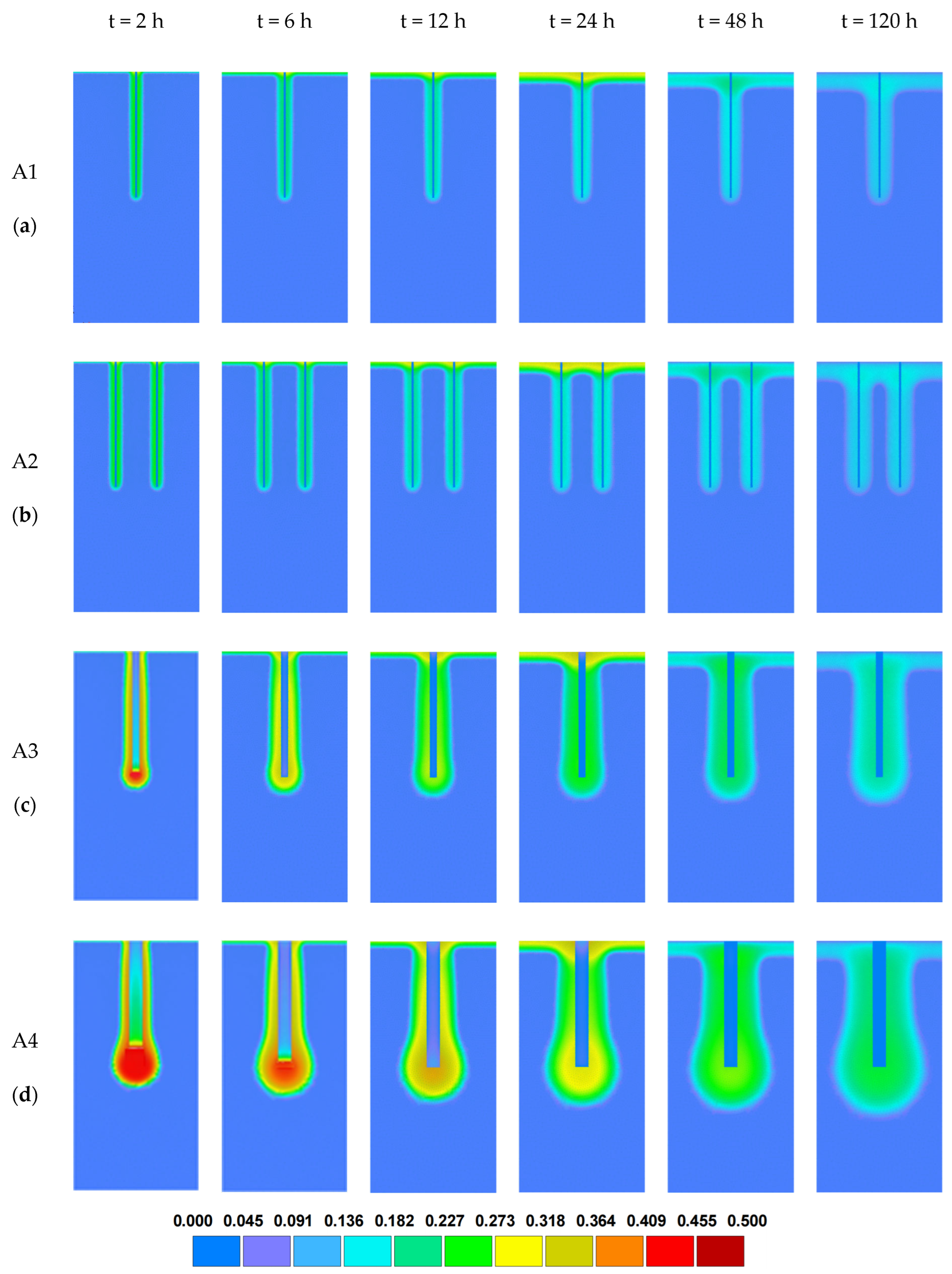
To evaluate the effect of crack structure on preferential flow, four crack scenarios were designed under identical conditions of moderate rainfall intensity and uniform soil texture. These included: A1 (one crack, width 1 cm), A2 (two cracks, width 1 cm), A3 (one crack, width 5 cm), and A4 (one crack, width 10 cm). The simulation outputs were analyzed at six representative time points—2 h, 6 h, 12 h, 24 h, 48 h, and 120 h—capturing the evolution of water infiltration over time. The results of water content distribution for each crack configuration are illustrated in Figure 5.
Figure 5.
Distribution of water content in the profile under different crack scenarios: (a) 1 crack, crack width L = 1 cm; (b) 2 cracks, crack width L = 1 cm; (c) 1 crack, crack width L = 5 cm; (d) 1 crack, crack width L = 10 cm.
By comparing the soil moisture distribution diagrams of scenarios A1–A4 under different crack conditions (Figure 5), it is evident that changes in crack number and width have a significant influence on the spatiotemporal distribution of soil moisture during the simulation period. The results reveal two key characteristics: First, preferential flow was observed in all scenarios. The crack acted as a dominant pathway for rapid water infiltration, substantially altering the water distribution pattern within the soil profile. For instance, in scenario A1 (one crack, width 1 cm), the wetting front advanced downward along the crack path, reaching a maximum depth of approximately 107.44 cm at t = 48 h, while infiltration into the matrix zone on either side of the crack remained relatively slow. In scenario A2 (two cracks, each 1 cm wide), the presence of multiple cracks led to the independent downward movement of several wetting fronts, resulting in a broader spatial distribution of preferential flow. In scenarios A3 and A4, where the crack widths were increased to 5 cm and 10 cm, respectively, water infiltrated much more rapidly along the wider cracks. The wetting front reached depths of 123.84 cm (A3) and 144.48 cm (A4) by t = 120 h, significantly deeper than those in A1 and A2. These results indicate that wider cracks strongly enhance preferential flow intensity and significantly accelerate the vertical migration of water. Second, increasing crack width also led to a notable expansion of the wetted area across the entire soil profile and a faster overall water migration rate. In scenarios A3 and A4, pronounced high-water-content zones were observed at the bottom and around the cracks, with a much larger wetted range compared to A1 and A2. This suggests that wider cracks not only promote deeper infiltration but also enhance water retention in deeper soil layers. Additionally, from t = 24 h to t = 120 h, after the rainfall ended, saturated water within the cracks began to diffuse slowly into the surrounding matrix, leading to a gradual redistribution of soil moisture. In A3 and A4, the highly saturated zone along the crack gradually extended laterally into the matrix, and the water content across the profile tended toward uniformity. This represents a typical transition process from preferential flow to matrix dispersion, indicating that crack configuration has a long-lasting influence on both water retention and redistribution during the post-rainfall period.
3.2. Variations in Soil Water Content Under Different Texture Scenarios
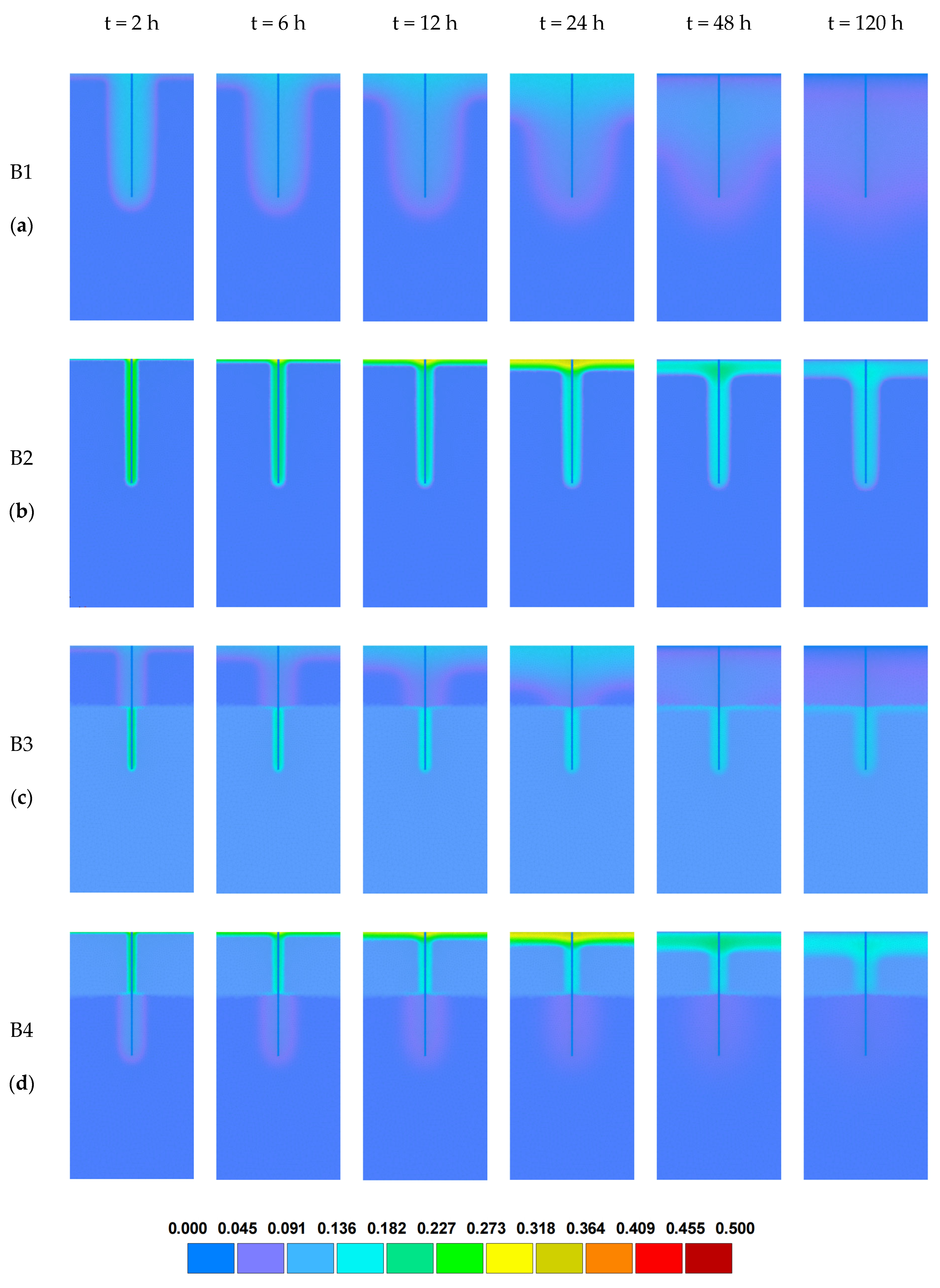
To investigate the influence of soil texture on water infiltration under preferential flow conditions, four simulation scenarios were established while keeping the crack structure (one crack, width 1 cm) and rainfall intensity (moderate rain) constant. The scenarios included: homogeneous sandy soil (B1), homogeneous loam soil (B2), layered profile with upper sandy soil (B3), and layered profile with upper loam soil (B4). The resulting soil moisture distributions for these scenarios are presented in Figure 6.
Figure 6.
Distribution of water content in the profile under different texture scenarios: (a) sandy soil; (b) loamy soil; (c) upper sandy and lower loamy soil; (d) upper loamy and lower sandy soil.
As shown in Figure 6 (B1–B4), soil texture has a significant impact on the spatial and temporal distribution of soil moisture. In all scenarios, obvious preferential flow phenomena are observed, characterized by the rapid infiltration of water along vertical cracks, forming banded zones of high-water content. This indicates that cracks play an important role in water transmission across all soil types. However, the intensity of preferential flow, wetting front velocity, and infiltration depth vary considerably among different textures. At the 12 h mark, the differences in preferential flow behavior between soil textures are particularly evident. In the B2 scenario (loam soil), water infiltrates significantly, and the wetting front reaches a depth of approximately 105.54 cm, forming a wide and well-defined preferential flow path. In contrast, in the B1 scenario (sandy soil), although preferential flow also occurs, the larger pores and weaker capillary forces result in a faster but narrower wetting front, with more uneven moisture distribution in the profile. In the B3 scenario (layered soil with upper sandy soil and lower loam), water infiltrates rapidly into the upper sandy layer, but accumulates at the interface with the underlying loam, forming a ponding zone and showing lateral moisture diffusion due to the capillary barrier effect. Conversely, in B4 (upper loam and lower sandy soil), the stronger water-holding capacity of the upper loam slows the advance of the wetting front. However, once the moisture breaks through into the lower sandy layer, it infiltrates rapidly, forming a deep preferential flow channel. At t = 24 h, the wetting front depths of scenarios B1, B2, B3, and B4 are approximately 121.86 cm, 105.55 cm, 105.56 cm, and 51.95 cm, respectively. Loam soil (B2) achieves the deepest and most sustained preferential flow under uniform conditions, indicating its greater ability to retain and conduct water. In contrast, the layered soils (B3 and B4) introduce interface effects, leading to retarded or accelerated wetting fronts, and thus more complex water migration behavior. By t = 48 h and 120 h, soil moisture distribution tends to stabilize across all scenarios. Preferential flow paths gradually extend into the surrounding matrix, and the moisture profiles become more uniform, highlighting the role of post-infiltration redistribution. Notably, the rate of redistribution and the final extent of wetted zones differ depending on soil texture. In conclusion, soil texture significantly influences preferential flow in macroporous media. Loam soil is more conducive to forming continuous and stable preferential flow channels, while layered soils exhibit complex infiltration behavior, including wetting front delays, acceleration, and capillary barriers, all of which contribute to more heterogeneous water transport dynamics.
3.3. Variations in Soil Water Content Under Different Rainfall Scenarios
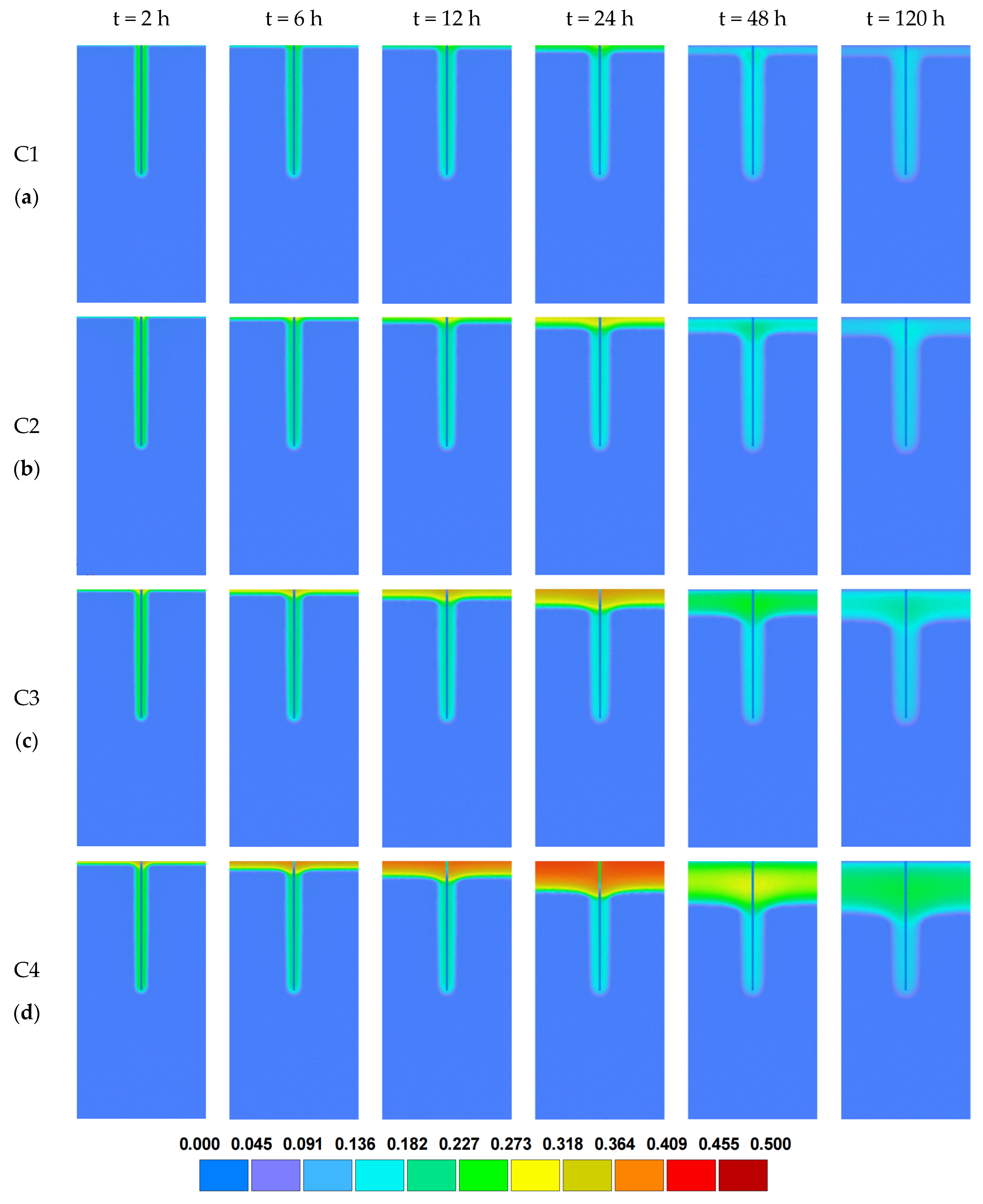
To investigate the influence of rainfall intensity on water infiltration under preferential flow conditions, four rainfall scenarios were simulated while keeping the soil texture (loam) and crack structure (one crack, 1 cm wide) constant. The rainfall scenarios included: light rain (C1, 8 mm), moderate rain (C2, 18 mm), heavy rain (C3, 38 mm), and rainstorm (C4, 75 mm). The resulting moisture content distributions for each rainfall intensity are presented in Figure 7.
Figure 7.
Distribution of water content in the profile under different rainfall scenarios: (a) 8 mm; (b) 18 mm; (c) 38 mm; (d) 75 mm.
The simulation results clearly show that preferential flow occurs under all rainfall scenarios, characterized by rapid water infiltration along the crack and the formation of narrow, vertically elongated high-moisture zones. However, as rainfall intensity increases, the preferential flow paths become more defined and continuous, and the wetting front advances at a significantly faster rate. Higher rainfall intensity enhances both the velocity of water migration through macropores and the overall intensity of preferential flow. Secondly, rainfall intensity also affects the morphology of the wetting front. In light (C1) and moderate (C2) rain scenarios, the wetting front tends to be smoother and more gradual. In contrast, under heavy rain (C3) and rainstorm (C4) conditions, the wetting front becomes steeper and more penetrative, rapidly reaching the middle or lower portions of the soil profile even during the early stages of infiltration (e.g., at t = 6 h). In the later stages of the simulation (e.g., at t = 48 h and 120 h), after the rainfall ceases, moisture redistribution occurs gradually within the profile. In high-intensity rainfall scenarios (C3 and C4), the wetted area expands, saturation levels increase, and deep soil moisture content rises significantly. In contrast, in the light rain scenario (C1), water tends to accumulate near the surface, while deeper layers remain largely dry. This highlights that rainfall intensity is a critical factor influencing both the formation and development of preferential flow. In conclusion, under the same soil texture and crack conditions, rainfall intensity exerts a greater influence on the preferential flow process than crack width. As rainfall intensity increases, water migration becomes faster, the wetting front penetrates deeper, and preferential flow pathways become more stable and continuous. Thus, rainfall intensity can be considered one of the primary controlling factors driving the occurrence and evolution of macropore-induced preferential flow in unsaturated soils.
3.4. Comparison of Infiltration Process Under Different Scenarios
To further quantify the effects of different influencing factors on infiltration behavior, a statistical analysis was conducted on the wetting front depths in both the matrix zone and the crack zone under all simulation scenarios. Since the maximum moisture content in the matrix area typically appears near the soil surface during rainfall, three representative time points—24 h, 48 h, and 120 h—were selected for comparison. The cumulative wetting front depths at these time steps provide insight into the dynamic evolution of infiltration patterns under varying conditions. The detailed results are summarized in Table 2.
Table 2.
Maximum water content and wetting front depth throughout the profile at different times.
In the crack structure variation scenarios (A1–A4), the penetration depth in the crack zone increased significantly with increasing crack width. Although rainfall ceased after 24 h, the wetting front continued to advance, indicating that cracks could sustain water conduction even in the absence of ongoing rainfall. At 24 h, the wetting front in the crack zone extended from 105.55 cm (A1) to 135.60 cm (A4), and by 120 h, it reached 144.48 cm in A4. In contrast, infiltration depth in the matrix zone increased only slightly—from 10.78 cm to 16.86 cm in A1—mainly during the first 48 h, after which it stabilized. These findings demonstrate that wider cracks not only accelerate infiltration during rainfall but also sustain vertical water movement after rainfall ends. In the soil type scenarios (B1–B4), scenario B1 (sandy soil) exhibited the deepest wetting front in the matrix zone, reaching 99.16 cm at 120 h. Notably, the wetting front continued to advance after rainfall, indicating high permeability. The loam scenario (B2) behaved similarly to A1, with a slower wetting front progression. In layered soils, B3 (upper sandy soil, lower loam) reached 56.98 cm, while B4 (upper loam, lower sandy soil) only reached 21.84 cm at 120 h. These results indicate that the upper sandy layer in B3 facilitates rapid early-stage infiltration, but the lower loam layer impedes downward flow, resulting in water accumulation in the shallow layer. In the rainfall intensity scenarios (C1–C4), although rainfall lasted only until 24 h, the wetting front in the matrix zone continued to advance at 48 h and 120 h, correlating with increasing rainfall intensity. At 120 h, the wetting front depths in the matrix zone were 10.36 cm (C1), 16.86 cm (C2), 26.46 cm (C3), and 42.76 cm (C4). In contrast, the crack zone wetting front remained relatively constant after 24 h, ranging between 105.5 and 107.4 cm, suggesting that rainfall intensity primarily affects matrix infiltration, with limited influence on already saturated or near-saturated cracks.
In summary, the data in Table 2 confirm that even after rainfall ends at 24 h, water migration continues in both matrix and crack zones. The infiltration rate and depth are strongly influenced by crack width, soil texture, and rainfall intensity. These findings demonstrate the distinct roles that structural and environmental factors play in governing preferential flow dynamics in unsaturated cracks soils. Specifically, wider cracks enable the wetting front in the crack zone to continue penetrating deeper even after rainfall ends, maintaining strong vertical water transport. Meanwhile, sandy soils, due to their high permeability and weak capillary forces, promote faster and deeper water infiltration within the matrix zone. Furthermore, increasing rainfall intensity significantly enhances the depth and extent of water migration, especially in the matrix, by accelerating wetting front advancement and enlarging the wetted area. Collectively, these results highlight how crack structure, soil texture, and rainfall intensity interact to control the formation, persistence, and redistribution of preferential flow under different hydrological conditions.
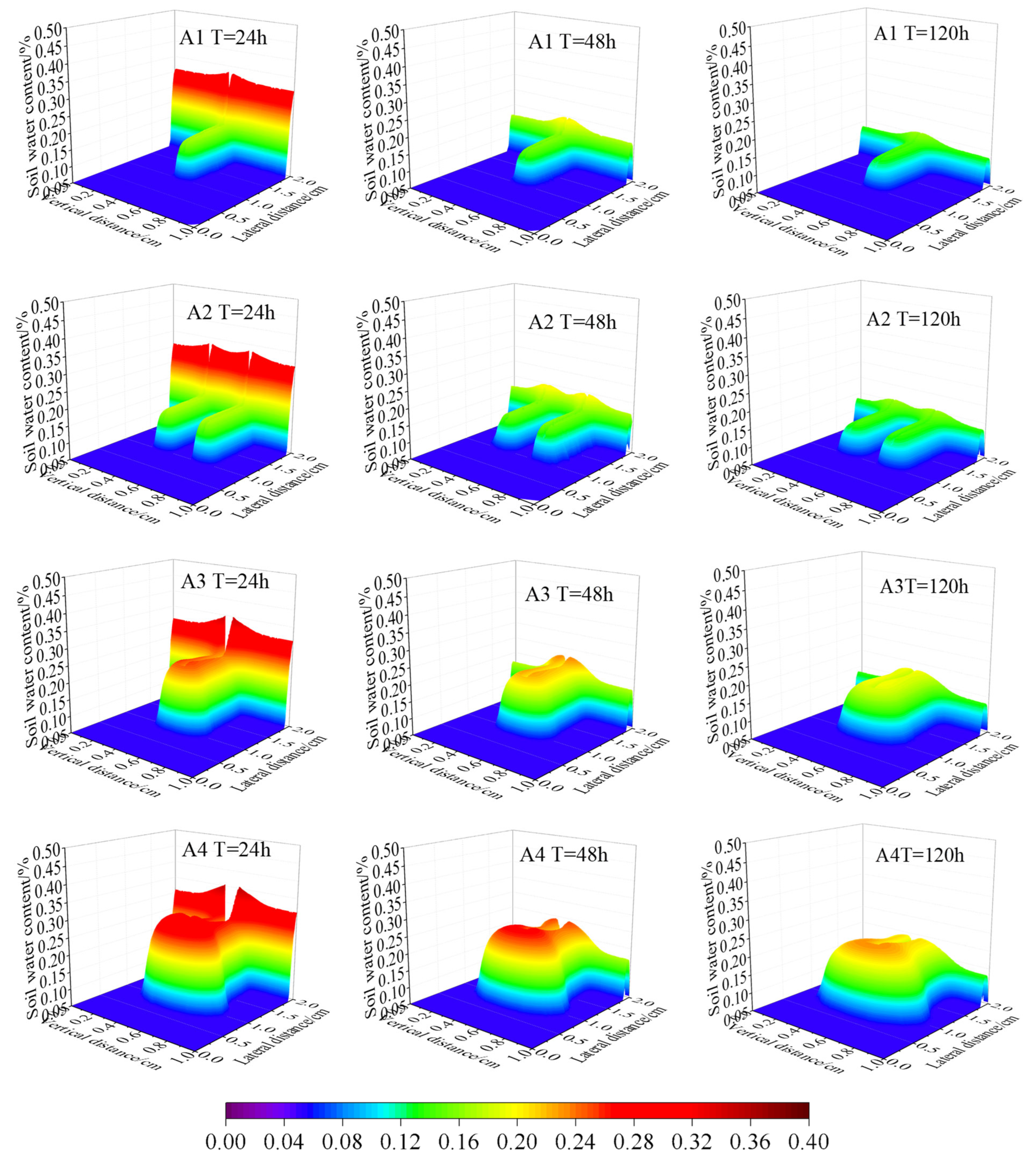
Figure 8 presents the three-dimensional distribution of soil water content at 24 h, 48 h, and 120 h under different crack width scenarios: 1 cm (A1, A2), 5 cm (A3), and 10 cm (A4). The horizontal and longitudinal coordinates correspond to the actual length and width of the study area shown in Figure 4, while the vertical axis represents the simulated volumetric water content. All boundary conditions and soil parameters are consistent with those of the field domain, ensuring that the spatial distribution of simulated moisture directly reflects the real topography and stratigraphy of the site. These visualizations reflect the spatiotemporal migration characteristics of soil water influenced by crack structure. At the end of the 24 h rainfall period, a high-moisture zone centered along the crack appears in all scenarios. In A3 and A4, the soil water content near the crack rises sharply, with maximum values exceeding 0.36 cm3/cm3, indicating a distinct peak enrichment effect. In contrast, A1 and A2 show relatively lower peak moisture values and narrower wetting zones, suggesting that wider cracks are more effective in creating concentrated water accumulation under the same rainfall conditions. By 48 h (i.e., 24 h after rainfall cessation), vertical expansion of the high-moisture regions becomes evident. In A1 and A2, water continues to migrate slowly downward within the crack, and moisture penetration into the surrounding matrix remains limited. However, in A3 and A4, infiltration occurs over a broader area beneath the crack, and wet zones advance deeper into the profile while maintaining high moisture concentrations. This demonstrates that wide cracks can sustain preferential flow, promoting deep water migration even after rainfall ends. At 120 h, the differences between scenarios become more pronounced. The high-moisture zones in A1 and A2 appear flattened and are largely confined to shallow layers, with no clear downward extension of the wetting front. Conversely, A3 and especially A4 exhibit deep, well-defined moisture zones, with A4 forming a stable, saturated channel extending into the middle and lower parts of the profile. The downward shift of the peak moisture zone in A4 reflects the continued downward transport of water, driven by the presence of a wide crack. In summary, Figure 7 clearly illustrates that crack width significantly influences the spatiotemporal dynamics of soil moisture migration. As crack width increases from 1 cm to 10 cm, both the peak moisture content and the spatial extent of the wetted area increase, and the wetting front penetrates deeper into the soil profile. This indicates that wider cracks not only enhance infiltration during rainfall but also promote continuous downward water migration after rainfall, thereby intensifying the development and persistence of preferential flow in the soil.
Figure 8.
Three-dimensional distribution of soil water content at 24 h, 48 h, and 120 h under different crack width scenarios (A1–A4) (The spatial coordinates correspond to the actual domain shown in Figure 3, and the vertical axis denotes the volumetric soil water content).
4. Discussion
4.1. Effect of Crack Geometry on Preferential Flow
Cracks serve as critical conduits for water migration in the unsaturated (vadose) zone, and their geometric characteristics exert significant control over water distribution and flow pathways. This section explores the mechanisms by which crack density, width, length, and connectivity influence preferential flow and infiltration processes in mining-affected vadose zones. Crack density, defined as the number of cracks per unit area or volume, directly affects the heterogeneity of the soil profile. An increase in crack density enhances the likelihood of preferential flow by allowing water to bypass the capillary resistance of the soil matrix, enabling rapid infiltration and even lateral water movement []. Particularly under abrupt water input events (e.g., rainfall or irrigation), high-density crack networks increase the number of potential entry and exit points for water, accelerating vertical infiltration rates []. However, excessive crack density may lead to reduced connectivity, resulting in blind or isolated cracks that fail to contribute to effective flow pathways, thereby diminishing overall water migration efficiency. Crack width plays a direct role in determining hydraulic conductivity within cracks. Wider cracks act as high-permeability channels, capable of accommodating greater volumes of water and promoting faster infiltration []. These wide cracks are more likely to overcome capillary resistance and support gravity-driven flow, resulting in non-uniform moisture distributions across the vadose zone. Furthermore, the upper portions of wide cracks are more susceptible to evaporation, leading to steep vertical moisture gradients—findings consistent with studies on crack-evaporation coupling effects []. Crack length affects the spatial extent of water transport. Longer cracks, especially those with vertical orientation, can facilitate the deep percolation of surface water into lower vadose or even saturated zones []. In contrast, shorter cracks may restrict vertical transport, resulting in water accumulation in shallow layers or increased lateral diffusion, thereby limiting the effective infiltration depth. Crack connectivity, defined as the spatial interlinkage of individual cracks, is a key factor controlling the development of three-dimensional water migration networks. High-connectivity crack systems promote both vertical and lateral flow, enhancing the continuity of preferential pathways []. In contrast, poorly connected cracks may trap water in localized zones, forming water seals or perched water tables, and inhibit further downward infiltration. In mining environments, anthropogenic disturbances often alter crack connectivity, suggesting the need for dynamic simulation models that account for crack evolution over time [].
This study systematically reveals the roles of crack width, number, and connectivity in shaping preferential flow patterns and infiltration efficiency. Notably, it highlights the inhibitory effect of blind cracks—those lacking effective connectivity—on water transport, an aspect that is often overlooked. These findings contribute to a deeper understanding of the conditions required for preferential flow formation, and offer a theoretical basis for modeling crack–water interactions in coal mining subsidence zones.
4.2. Soil Water Cycle Mechanism in Subsidence Areas
Surface subsidence caused by coal mining not only alters local geomorphology but also profoundly impacts the soil water cycle in the unsaturated (vadose) zone. The development of subsidence-induced crack structures disrupts the original hydrological equilibrium, changing both the pathways and dynamics of water migration in these areas [].
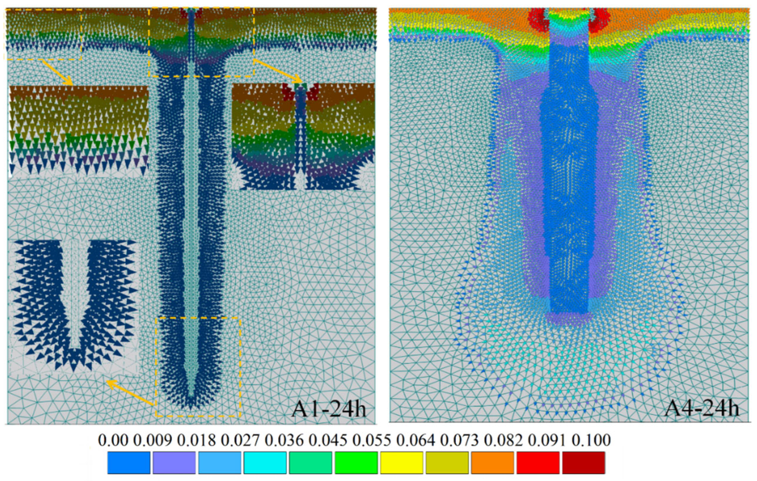
In undisturbed regions, soil water typically infiltrates vertically, driven by capillary forces and gravity, and gradually moves downward toward the saturated zone. However, in mining subsidence areas, the formation of vertical tensile cracks and penetrating cracks creates low-resistance channels that alter the direction of water flow. These cracks facilitate the rapid downward transport of water through the vadose zone, potentially allowing surface moisture to reach deep aquifers or goaf areas much faster than in undisturbed soils. Additionally, the lateral propagation of cracks enhances horizontal water migration, forming a complex three-dimensional preferential flow network. Simulation results from the Hydrus-2D model demonstrate substantial differences in water migration patterns under different crack conditions is illustrated in Figure 9 []. In the narrow-crack scenario (A1, crack width < 5 cm), high seepage velocities are concentrated within the crack and its immediate vicinity, forming a single, slender vertical channel. In contrast, the wide-crack scenario (A4, crack width ≥ 5 cm) exhibits significantly increased vertical flow, with feather-like high-velocity zones spreading along both sides of the crack wall. This threshold value of 5 cm was selected based on field investigations and previous studies, which indicate that cracks wider than 5 cm can maintain structural continuity and serve as dominant preferential flow paths, while smaller cracks are more likely to collapse or self-seal after rainfall []. As a result, the wide-crack condition leads to enhanced lateral seepage, allowing water to diffuse rapidly into deeper layers and the surrounding matrix []. The presence of cracks dramatically increases vertical water flux in subsidence areas. Under the same rainfall conditions, cracked zones exhibit much higher infiltration rates compared to non-cracked zones, with local maximum fluxes reaching several times greater than those in undisturbed soils. This rapid infiltration reduces the contact time between infiltrating water and the surrounding soil, limiting moisture retention and exchange with the soil matrix, and increasing the risk of contaminant transport to deeper groundwater []. Additionally, the accelerated loss of soil moisture reduces the water-holding capacity of the soil, making subsidence areas more prone to dry–wet cycles, which can trigger secondary cracking and further degrade soil structure.
Figure 9.
Comparison of the infiltration velocity vector of scenarios A1 and A4 at 24 h.
These findings reveal that subsidence-induced cracks significantly accelerate rainfall infiltration, forming a rapid infiltration–migration–recharge/evaporation cycle. This model captures, for the first time, the multi-directional and dynamic nature of the water cycle in crack-affected vadose zones. It not only increases the responsiveness of surface water to deep groundwater recharge but also amplifies the environmental risks to groundwater resources. Overall, crack development in subsidence areas plays a decisive role in shaping regional hydrological processes and groundwater security [,].
4.3. Deficiencies and Prospects
This study employed a two-dimensional dual-domain (crack–matrix) model to investigate the dynamic process of water migration in the vadose zone under varying crack development conditions. The model successfully revealed the influence of crack structure on preferential flow pathways and water exchange mechanisms. However, there remain several limitations that warrant improvement and expansion in future research.
First, the model incorporates crack density, width, length, and connectivity through parameterization, enabling it to represent complex crack networks and improving its applicability to the structural characteristics of real-world subsidence-affected areas []. The use of the dual-porosity conceptual framework allows for the effective coupling of water exchange between cracks and the soil matrix, providing a more realistic representation of water migration processes []. The model is also capable of handling complex boundary conditions, such as structural heterogeneity and abrupt hydrological inputs caused by mining-induced disturbances, making it well-suited for hydrological studies in severely disturbed environments []. Nevertheless, the present study has not yet been validated against field measurement data. The modeling work was designed to reproduce a preferential infiltration phenomenon observed during field investigations using a controlled HYDRUS-2D framework. Although the simulation parameters were derived from field-based soil and rainfall conditions, direct quantitative validation through field monitoring is still lacking. Future research will include laboratory infiltration experiments and field measurements to verify and calibrate the model’s performance. Moreover, the integration of HYDRUS-2D with high-resolution hydrological or microscopic models will be explored to investigate the preferential flow mechanism at finer spatial and temporal scales, thereby improving the model’s robustness and applicability. Despite these strengths, the study primarily focuses on the infiltration process within the crack–matrix system, without accounting for the feedback effects of groundwater table fluctuations. Groundwater depth and its dynamic changes often have a significant impact on the intensity of water exchange within the unsaturated zone []. Furthermore, the model simplifies several key eco-hydrological processes, including root water uptake, gas transport, and solute transport, and therefore does not fully capture the coupling between ecological and hydrological interactions. Additionally, while the use of 2D profile simulations reduces computational cost, it limits the ability to simulate three-dimensional crack networks and fails to account for dynamic crack propagation driven by ongoing mining activities []. Although this study did not include direct validation with field-measured data, it represents a mechanistic and scenario-based exploration of water migration in cracked vadose zones. Due to the complex and heterogeneous nature of field-scale mining-induced cracks, direct quantitative validation remains highly challenging. In this work, the crack structures were simplified based on field investigation and laboratory testing, allowing the coupled simulation of macropore flow and matrix flow within a representative conceptual framework. It should be noted, however, that the spatial distribution of ground cracks is highly irregular, which makes their accurate characterization in numerical models extremely complex. This study provides valuable theoretical insights into the dominant hydrological processes and offers a methodological reference for subsequent investigations. Future work will focus on conducting in situ monitoring within subsidence zones to further validate and refine the model. In line with the reviewer’s valuable recommendation, we also plan to begin with simplified and controlled scenarios—such as isotropic and homogeneous field conditions—to gradually improve the understanding and representation of preferential infiltration processes. Such efforts will contribute to building a more robust and comprehensive modeling framework for water migration in fractured unsaturated zones.
To address these limitations, future research should prioritize enhanced field monitoring, multi-source data fusion, and the tight coupling of simulation models with real-world observations. These efforts would improve model reliability and facilitate a more comprehensive understanding of vadose zone hydrodynamics under mining disturbance. In summary, this study provides a new analytical framework for exploring water migration mechanisms in subsidence-disturbed unsaturated zones. It highlights the regulatory role of crack structure in shaping heterogeneous hydrological processes. From a theoretical perspective, the findings contribute to a deeper understanding of crack–matrix interaction mechanisms. From an applied standpoint, the results offer valuable scientific references for ecological restoration, land reclamation, and regional water resource management in coal mining areas. Although the study has certain limitations, the concepts and methods proposed herein lay a solid foundation for future research on multi-process coupled modeling and cross-scale hydrological synthesis [,].
5. Conclusions
In this study, the Hydrus-2D dual-domain seepage model was employed to simulate the water migration process in the vadose zone of a coal mining subsidence area. The coupled effects of crack geometry, soil texture, and rainfall intensity on preferential flow were systematically and quantitatively analyzed. The results indicate that increasing crack width from 1 cm to 10 cm leads to a significant increase in the maximum infiltration depth of the crack wetting front—from approximately 107 cm to 144 cm within 120 h. In sandy soil, the matrix wetting front depth reached up to 99 cm, which is about 40% greater than in loamy soil. Under heavy rainfall conditions, the wetting front in the matrix zone penetrated more than four times deeper than under light rainfall. These results reveal that crack width is the dominant factor controlling the depth and continuity of preferential flow, while soil texture determines the stability and redistribution of flow channels, and rainfall intensity governs the overall infiltration rate.
The simulated preferential flow pattern corresponds well with the geological structure of the study area, where sandy loam and weathered sandstone layers facilitate rapid vertical recharge through surface fractures. This consistency highlights the hydrogeological role of mining-induced cracks in linking the unsaturated zone with the underlying aquifers. Due to the simplified representation of crack geometry in the model and the omission of vegetation root effects, certain discrepancies exist between the simulated and actual results. Nevertheless, the simulation outcomes, supported by previous experimental and field investigation data, provide valuable theoretical insights for future research and offer meaningful guidance for ecological restoration and water resource management in mining-affected areas.
Author Contributions
S.L.: Writing—original draft, Investigation; N.G.: Methodology, Writing—review and editing; W.L.: Methodology, Data curation; D.L.: Writing—review and editing, Funding acquisition; W.M.: Data curation, Investigation; C.Z.: Supervision, Writing—review and editing; J.F.: Supervision, Funding acquisition. All authors have read and agreed to the published version of the manuscript.
Funding
This research was funded by the Open Fund of State Key Laboratory of Water Resource Protection and Utilization in Coal Mining (Grant No. NICE_RD_2024_301), and the Science and Technology Innovation Foundation of Comprehensive Survey & Command Center for Natural Resources (Grant No. KC20240015).
Data Availability Statement
The original contributions presented in this study are included in the article. Further inquiries can be directed to the corresponding author.
Conflicts of Interest
Author Wei Li was employed by the company Shaanxi Institute of Engineering Prospecting Co., Ltd. The remaining authors declare that the research was conducted in the absence of any commercial or financial relationships that could be construed as a potential conflict of interest.
References
- Hu, E.C.; Gao, R.H. Spatial distribution pattern of colonized native semi-shrubs in two artificial vegetation restoration patterns in Mu Us sandy land, North China. PLoS ONE 2024, 19, e0304204. [Google Scholar] [CrossRef] [PubMed]
- Wang, Y.; Zhang, H.; Sun, Y.; Wang, J.; Shi, L. Simulation of layered soil water transport in the semi-arid region based on Hydrus-3D. PLoS ONE 2025, 20, e0321537. [Google Scholar] [CrossRef]
- Dong, J.H.; Dai, W.T.; Xu, J.R.; Zhang, H.; Li, Y.P.; Xie, F. Impact and elastic modulus of coal mining on terrestrial ecosystems. Sci. Rep. 2025, 15, 16. [Google Scholar] [CrossRef]
- Xiang, H.X.; Wang, Z.M.; Mao, D.H.; Zhang, J.; Zhao, D.; Zeng, Y.; Wu, B.F. Surface mining caused multiple ecosystem service losses in China. J. Environ. Manag. 2021, 290, 9. [Google Scholar] [CrossRef]
- Zhao, J.G.; Song, S.; Zhang, K.; Li, X.N.; Zheng, X.H.; Wang, Y.J.; Ku, G.Y. An investigation into the disturbance effects of coal mining on groundwater and surface ecosystems. Environ. Geochem. Health 2023, 45, 7011–7031. [Google Scholar] [CrossRef]
- Bai, L.; Wang, Y.; Zhang, K.; Yang, Y.; Bao, K.; Zhao, J.; Li, X. Spatial variability of soil moisture in a mining subsidence area of northwest China. Int. J. Coal Sci. Technol. 2022, 9, 64. [Google Scholar] [CrossRef]
- Lv, G.; Li, J.; Li, Y.X.; Wang, T.; Liu, Y.Z.; Fu, X.Y. Preferential flow characteristics of reclaimed mine soils in a surface coal mine dump. Environ. Monit. Assess. 2017, 189, 21. [Google Scholar] [CrossRef] [PubMed]
- Bi, Y.L.; Du, X.P.; Tian, L.X.; Li, M.C.; Yin, K.J. Effects of an arbuscular mycorrhizal fungus on Amorpha fruticosa roots and soil preferential flow in an arid area of opencast coal mine waste. Soil Tillage Res. 2025, 245, 13. [Google Scholar] [CrossRef]
- Liu, R.F.; Zhou, J.Q.; Chui, T.F.M.; Liu, D.F.; Liu, Y. Preferential Flow in Common Low Impact Development Technologies: A Review. Water Resour. Manag. 2025, 22. [Google Scholar] [CrossRef]
- Wen, Y.F.; Li, M.Z.; Gao, P.; Zhou, J.H.; Ai, X.C.; Zhang, Y.X.; Mu, X.M. Soil physicochemical properties and roots promoted preferential flow development after vegetation restoration. J. Hydrol. 2025, 659, 18. [Google Scholar] [CrossRef]
- Tang, Q.C.; Duncan, J.M.; Guo, L.; Lin, H.; Xiao, D.C.; Eissenstat, D.M. On the controls of preferential flow in soils of different hillslope position and lithological origin. Hydrol. Process. 2020, 34, 4295–4306. [Google Scholar] [CrossRef]
- Li, M.F.; Yao, J.J.; Yan, R.; Cheng, J.H. Effects of Infiltration Amounts on Preferential Flow Characteristics and Solute Transport in the Protection Forest Soil of Southwestern China. Water 2021, 13, 1301. [Google Scholar] [CrossRef]
- Niu, X.H.; Feng, G.R.; Liu, Q.; Han, Y.N.; Qian, R.P. Numerical investigation on mechanism and fluid flow behavior of goaf water inrush: A case study of Dongyu coal mine. Nat. Hazards 2022, 113, 1783–1802. [Google Scholar] [CrossRef]
- Qian, J.Z.; Wang, W.; Ma, L.; Dang, B.Q.; Sun, X.F. Identification of preferential flow paths by hydraulic tomography compared with tracer test and the groundwater contour map in coal mine water hazard area. J. Hydrol. 2024, 631, 14. [Google Scholar] [CrossRef]
- Mao, W.; Zhu, Y.; Ye, M.; Zhang, X.P.; Wu, J.W.; Yang, J.Z. A new quasi-3-D model with a dual iterative coupling scheme for simulating unsaturated-saturated water flow and solute transport at a regional scale. J. Hydrol. 2021, 602, 17. [Google Scholar] [CrossRef]
- Sarma, R.; Singh, S.K. Simulating contaminant transport in unsaturated and saturated groundwater zones. Water Environ. Res. 2021, 93, 1496–1509. [Google Scholar] [CrossRef]
- Min, L.L.; Shen, Y.J.; Pei, H.W.; Wang, P. Water movement and solute transport in deep vadose zone under four irrigated agricultural land-use types in the North China Plain. J. Hydrol. 2018, 559, 510–522. [Google Scholar] [CrossRef]
- Lu, T.T.; Bai, X.; Chen, B.D.; Peng, H.; Tang, S.C. Effects of different environmental factors on solute transport in the capillary fringe. Hydrogeol. J. 2024, 32, 2203–2212. [Google Scholar] [CrossRef]
- Xia, Y.; Zhen, W.Y.; Huang, H.S.; Zhang, Y.; Tang, Q.H.; Liu, H.L. Research on the Fissure Development and Seepage Evolution Patterns of Overburden Rock in Weakly Cemented Strata Under Repeated Mining. Sustainability 2025, 17, 2780. [Google Scholar] [CrossRef]
- Li, Y.X.; Lv, G.; Shao, H.B.; Dai, Q.H.; Du, X.P.; Liang, D.; Kuang, S.P.; Wang, D.H. Determining the influencing factors of preferential flow in ground fissures for coal mine dump eco-engineering. PeerJ 2021, 9, 27. [Google Scholar] [CrossRef]
- Ling, C.W.; Liu, B.; Zhang, C.; Teng, T.; Zhang, K.N.; Sun, B.; Zhou, J.L. Fractal Characteristics of Overburden Rock Fractures and Their Impact on Ground Fissures in Longwall Coal Mining. Fractal Fract. 2023, 7, 699. [Google Scholar] [CrossRef]
- Li, S.N.; Lu, T.; Zhou, K.X.; Gu, Y.D.; Wang, B.H.; Lu, Y.D. Modeling and Application of the Hydrus-2D Model for Simulating Preferential Flow in Loess Soil Under Various Scenarios. Water 2024, 16, 3653. [Google Scholar] [CrossRef]
- Xu, X.X.; Kalhoro, S.A.; Chen, W.Y.; Raza, S. The evaluation/application of Hydrus-2D model for simulating macro-pores flow in loess soil. Int. Soil Water Conserv. Res. 2017, 5, 196–201. [Google Scholar] [CrossRef]
- Yang, M.P.; Pan, Y.Y.; Feng, H.Y.; Yan, Q.; Lu, Y.J.; Wang, W.X.; Qi, Y.; Zhu, H.J. Fractal Characteristics of Pore Structure of Longmaxi Shales with Different Burial Depths in Southern Sichuan and Its Geological Significance. Fractal Fract. 2025, 9, 2. [Google Scholar] [CrossRef]
- Zhu, H.; Ju, Y.; Lu, Y.; Yang, M.; Feng, H.; Qiao, P.; Qi, Y. Natural evidence of organic nanostructure transformation of shale during bedding-parallel slip. Geol. Soc. Am. Bull. 2025, 137, 2719–2746. [Google Scholar] [CrossRef]
- Jafari, Z.; Matinkhah, S.H.; Mosaddeghi, M.R. Wetting Patterns in a Subsurface Irrigation System Using Reservoirs of Different Permeabilities: Experimental and HYDRUS-2D/3D Modeling. Water Resour. Manag. 2022, 36, 5335–5352. [Google Scholar] [CrossRef]
- Song, Z.H.; Zhang, J.; Chi, M.B.; Guo, N.; Yang, S.; Guo, Y.N.; He, R.M.; Gao, Z. The Influence of the Morphological Characteristics of Mining-Induced Ground Fissures on the Spatiotemporal Distribution of Soil Moisture. Water 2024, 16, 2496. [Google Scholar] [CrossRef]
- Li, J.M.; Wu, L.W.; Huang, Y.L.; Hu, B.; Wu, X.R.; Cao, G.L. Characteristics of soil moisture transport in the aeration zone of subsidence areas under the disturbance of coal seam mining, Geomech. Geophys. Geo-Energy Geo-Resour. 2024, 10, 17. [Google Scholar] [CrossRef]
- Zhang, K.; Yang, K.; Wu, X.T.; Bai, L.; Zhao, J.G.; Zheng, X.H. Effects of Underground Coal Mining on Soil Spatial Water Content Distribution and Plant Growth Type in Northwest China. ACS Omega 2022, 7, 18688–18698. [Google Scholar] [CrossRef]
- Zhang, C.Y.; Chen, F.; Sun, L.; Ma, Z.C.; Yao, Y. A new seasonal frozen soil water-thermal coupled migration model and its numerical simulation. PLoS ONE 2021, 16, e0258861. [Google Scholar] [CrossRef]
- Yan, W.T.; Guo, J.T.; Chen, J.J.; Tan, Y.; Yan, S.G.; Yan, Y.G. Severe Damage Law on the Ground Surface Induced by High-Strength Mining: A Case Study from the Shendong Coal Field in China. Front. Earth Sci. 2022, 10, 10. [Google Scholar] [CrossRef]
- Wang, W.; Zhao, W.D.; Qian, J.Z.; Ma, L.; Wang, D.J.; Hou, X.L. Potential of hydraulic tomography in exploring the preferential flowpaths of water inrush in coal mine areas. J. Hydrol. 2021, 602, 12. [Google Scholar] [CrossRef]
- Zhao, Y.X.; Ling, C.W.; Zhang, K.N.; Gao, Y.R.; Sun, B.; Wang, X.L. Detection of hidden mining-induced ground fissures via unmanned aerial vehicle infrared system and ground-penetrating radar. Int. J. Rock. Mech. Min. Sci. 2022, 160, 10. [Google Scholar] [CrossRef]
- Li, X.P.; Xiao, P.Q.; Hao, S.L.; Wang, Z.H. Rainfall Erosivity Characteristics during 1961–2100 in the Loess Plateau, China. Remote Sens. 2024, 16, 661. [Google Scholar] [CrossRef]
- Wang, S.T.; Cao, Z.; Luo, P.P.; Zhu, W. Spatiotemporal Variations and Climatological Trends in Precipitation Indices in Shaanxi Province, China. Atmosphere 2022, 13, 744. [Google Scholar] [CrossRef]
- Yin, L.H.; Hu, G.C.; Huang, J.T.; Wen, D.G.; Dong, J.Q.; Wang, X.Y.; Li, H.B. Groundwater-recharge estimation in the Ordos Plateau China: Comparison of methods. Hydrogeol. J. 2011, 19, 1563–1575. [Google Scholar] [CrossRef]
- Richards, L.A. Capillary conduction of liquids through porous mediums. Physics 1931, 1, 318–333. [Google Scholar] [CrossRef]
- Mualem, Y. A new model for predicting the hydraulic conductivity of unsaturated porous media. Water Resour. Res. 1976, 12, 513–522. [Google Scholar] [CrossRef]
- Vangenuchten, M.T. A Closed-form Equation for Predicting the Hydraulic Conductivity of Unsaturated Soils. Soil Sci. Soc. Am. J. 1980, 44, 892–898. [Google Scholar] [CrossRef]
- Zheng, C.; Simunek, J.; Lu, Y.D.; Liu, X.H.; Shi, C.C.; Li, H.H. Monitoring and modeling the coupled movement of water, vapor, and energy in arid areas. J. Hydrol. 2020, 590, 16. [Google Scholar] [CrossRef]
- Guan, N.; Cheng, J.H.; Bi, H.X.; Shi, X.Q. Laboratory and field characterization of preferential flow under consideration of geometric fracture features in a karst region in southwest China. J. Hydrol. 2024, 631, 12. [Google Scholar] [CrossRef]
- Beven, K.; Germann, P. Macropores and water flow in soils revisited. Water Resour. Res. 2013, 49, 3071–3092. [Google Scholar] [CrossRef]
- Simunek, J.; Jarvis, N.J.; van Genuchten, M.T.; Gärdenäs, A. Review and comparison of models for describing non-equilibrium and preferential flow and transport in the vadose zone. J. Hydrol. 2003, 272, 14–35. [Google Scholar] [CrossRef]
- Gerke, H.H. Preferential flow descriptions for structured soils. J. Plant Nutr. Soil Sci. 2006, 169, 382–400. [Google Scholar] [CrossRef]
- Caputo, M.C.; De Carlo, L.; Masciale, R.; Perkins, K.; Turturro, A.C.; Nimmo, J.R. Detection and quantification of preferential flow using artificial rainfall with multiple experimental approaches. Hydrogeol. J. 2024, 32, 467–485. [Google Scholar] [CrossRef]
- Vogel, H.J.; Weller, U.; Ippisch, O. Non-equilibrium in soil hydraulic modelling. J. Hydrol. 2010, 393, 20–28. [Google Scholar] [CrossRef]
- Luan, J.K.; Zhang, Y.Q.; Tian, J.; Meresa, H.; Liu, D.F. Coal mining impacts on catchment runoff. J. Hydrol. 2020, 589, 13. [Google Scholar] [CrossRef]
- Liang, S.; Zhang, X.P.; Ke, F.H.; Liu, J.H.; Yao, Q.L.; Luo, H.Y.; Li, X.H.; Xu, Y.N. Evolution of Overlying Strata Bed Separation and Water Inrush Hazard Assessment in Fully Mechanized Longwall Top-Coal Caving of an Ultra-Thick Coal Seam. Water 2025, 17, 850. [Google Scholar] [CrossRef]
- Simunek, J.; van Genuchten, M.T.; Sejna, M. Recent Developments and Applications of the HYDRUS Computer Software Packages. Vadose Zone J. 2016, 15, 25. [Google Scholar] [CrossRef]
- Ren, X.C.; Sun, W.F.; Lan, H.X.; Bao, H.; Li, L.P.; Liu, S.J.; Yan, C.G.; Wang, X.C.; Li, Z.C.; Tian, C.Y. Influence of tension cracks on moisture infiltration in loess slopes under high-intensity rainfall conditions. Sci. Rep. 2025, 15, 19. [Google Scholar] [CrossRef] [PubMed]
- Ping, J.H.; Yan, S.Y.; Gu, P.; Wu, Z.N.; Hu, C.H. Application of MIKE SHE to study the impact of coal mining on river runoff in Gujiao mining area, Shanxi, China. PLoS ONE 2017, 12, e0188949. [Google Scholar] [CrossRef] [PubMed]
- Jarvis, N.J. A review of non-equilibrium water flow and solute transport in soil macropores: Principles, controlling factors and consequences for water quality. Eur. J. Soil Sci. 2007, 58, 523–546. [Google Scholar] [CrossRef]
- Lewandowska, J.; Szymkiewicz, A.; Burzynski, K.; Vauclin, M. Modeling of unsaturated water flow in double-porosity soils by the homogenization approach. Adv. Water Resour. 2004, 27, 283–296. [Google Scholar] [CrossRef]
- Simunek, J.; Brunetti, G.; Jacques, D.; van Genuchten, M.T.; Sejna, M. Developments and applications of the HYDRUS computer software packages since 2016. Vadose Zone J. 2024, 23, 29. [Google Scholar] [CrossRef]
Disclaimer/Publisher’s Note: The statements, opinions and data contained in all publications are solely those of the individual author(s) and contributor(s) and not of MDPI and/or the editor(s). MDPI and/or the editor(s) disclaim responsibility for any injury to people or property resulting from any ideas, methods, instructions or products referred to in the content. |
© 2025 by the authors. Licensee MDPI, Basel, Switzerland. This article is an open access article distributed under the terms and conditions of the Creative Commons Attribution (CC BY) license (https://creativecommons.org/licenses/by/4.0/).