Abstract
Monitoring water quality parameters in coastal and estuarine environments is critical for assessing their ecological status and addressing environmental challenges. However, traditional in situ sampling programs are often constrained by limited spatial and temporal coverage, making it difficult to capture the complex variability in these dynamic systems. This study introduces a novel upscaling framework that leverages limited in situ measurements and airborne hyperspectral data to generate multiple conditional realizations of water quality parameter fields. These pseudo-measurements are statistically consistent with the original data and are used to calibrate inversion algorithms that relate satellite-derived reflectance data to water quality parameters. The approach was applied to Kaštela Bay, a semi-enclosed coastal area in the eastern Adriatic Sea, to map seasonal variations in water quality parameters such as Chlorophyll-a. The upscaling framework captured spatial patterns that were absent in sparse in situ observations and enabled regional mapping using Sentinel-2A satellite data at the appropriate spatial scale. By generating realistic pseudo-measurements, the method improved the stability and performance of satellite-based retrieval algorithms, particularly in periods of high productivity. Overall, this methodology addresses data scarcity challenges in coastal water monitoring and its application could benefit the implementation of European water quality directives through enhanced regional-scale mapping capabilities.
1. Introduction
Monitoring coastal water quality is critical for assessing ecosystem health, yet the inherent variability in biogeochemical parameters poses significant challenges, particularly in dynamic coastal and marine environments, where complex physical processes drive spatio-temporal heterogeneity [1,2,3]. Traditional in situ sampling, though precise, provides only point measurements and is often costly, time-consuming, and spatially limited, especially for lower- and middle-income countries [4].
In situ measurements are inherently limited in spatial coverage and sampling frequency, often failing to capture the heterogeneity of biogeochemical parameters in water at scales relevant to satellite pixels. This sparse sampling impedes the direct development of robust inversion models, as in situ data rarely align with the spatial and temporal integration of satellite observations [5,6]. Yet, without such models, regional-scale mapping of water quality parameters, essential for ecosystem management and policy decisions, remains unattainable. Bridging this gap requires innovative approaches to harmonize disparate data scales, ensuring that satellite-derived products are both accurate and representative of biogeochemical variability [7].
Recent advances in remote sensing have expanded our capacity to monitor water quality across larger scales. Hyperspectral (HS) sensors on-board airborne platforms enable the detailed detection of optically active constituents, though their spatial coverage and temporal resolution remain constrained together with uncertainties in instrument noise imperfect atmospheric correction [8,9,10,11]. In contrast, satellite-based multispectral sensors offer broader spatial coverage and frequent revisits but with coarser spectral and spatial resolutions. Unmanned aerial vehicles (UAVs) bridge some of these gaps by providing high-resolution hyperspectral data (350–1000 nm, narrow bands), yet their limited coverage and logistical demands hinder large-scale or frequent monitoring. Regardless of the sensing platform used, ground-truth measurements collected in situ remain essential for calibrating and validating various algorithms. In parallel, recent advances in machine learning and deep learning have also been applied to retrieve water quality parameters from satellite data [12,13,14].
Satellites equipped with multispectral sensors are the most widely available, typically offering a limited number of relatively broad spectral bands (ranging from 20 nm to 80 nm), with spatial resolutions from about 20 to 500 m. These sensors capture reflected radiation from the water’s surface across different wavelengths. After atmospheric correction, this information can be used to infer the inherent optical properties of various water quality parameters. Complementing satellite and airborne sensing platforms, UAV-mounted hyperspectral sensors offer high spectral resolution, capturing hundreds of narrow bands across the visible to shortwave infrared spectrum. These systems allow for fine-scale mapping of water optical properties but are constrained by limited spatial coverage and the need for repeated flights to monitor spatio-temporal changes. The spatial scales at which UAV HS and in situ samples collect data differ substantially from satellite sensors, often by several orders of magnitude, leading to a sampling volume mismatch on the order of .
In both the satellite remote sensing and UAV hyperspectral imaging, two important factors should be considered: spectral and spatial resolution [15]. Spectral resolution refers to the number and width of the spectral bands captured. In contrast, spatial resolution is determined by the pixel size, which depends on sensor specifications and flight altitude or satellite orbit parameters. Temporal mismatch between in situ sampling and satellite overpasses can introduce additional uncertainty in the retrieval process, however, it can be avoided by planning the field campaign to match satellite revisit times closely.
A key challenge lies in the disparity between sampling volumes: in situ measurements capture point-scale variability, while satellite pixels integrate signals over tens to hundreds of meters. This mismatch is exacerbated in optically complex coastal waters, where hydrodynamic processes and small-scale heterogeneity complicate the inversion of water quality parameters from spectral data [16]. Existing approaches often pair sparse in situ data directly with satellite reflectance, risking biases due to unresolved sub-pixel variability, atmospheric noise, and imperfect corrections [10]; while ad hoc solutions (e.g., filtering high-variability pixels) have been proposed [5], a systematic framework for reconciling scale differences is lacking.
This study introduces a novel upscaling methodology to address the spatial resolution gap between in situ/UAV HS data and satellite multispectral data. By treating water quality parameters as random fields and leveraging spectral analysis, we generate stochastic realizations conditioned on in situ measurements, effectively creating pseudo-measurements at satellite scales. This approach circumvents the limitations of sparse in situ data, enabling robust algorithm training across matched spatial supports. The averaged realization of generated random fields possesses a substantial amount of data, encompassing a much larger range of satellite reflectance data, which is seldom the case when designing an inversion algorithm directly from available sparse in situ samples.
The objective of this study is to demonstrate the upscaling framework using Sentinel-2 data (with 10–60 m resolution) to map Chlorophyll- (Chl-), a key phytoplankton biomass indicator, and validate its performance against traditional in situ–satellite pairings. The new inversion algorithm is developed from the satellite–pseudo data matching pairs, showed the improved performance compared to the direct pairing of satellite data and in situ measurements. The presented methodology advances the retrieval of coastal water quality parameters by explicitly accounting for spatial scale mismatches, and offers a pathway to more accurate and scalable monitoring programs for coastal areas.
2. Materials and Methods
2.1. Study Area
The study area is located along the central eastern Adriatic Sea coast, near the city of Split, Croatia (Figure 1). Most Croatian coastal areas, including Kaštela Bay, rely heavily on beach-based and nautical tourism for economic growth and development, and experience a typical Mediterranean climate characterized by hot, dry summers [17]. Kaštela Bay is subject to strong anthropogenic pressure from municipal and industrial wastewater discharges, along with the river Jadro estuary at the eastern part of the bay. Recent studies of the trophic status of Kaštela Bay indicate a predominantly low productivity environment with oligotrophic conditions, consistent with the central–eastern Adriatic Sea [18,19,20].
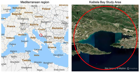
Figure 1.
The study area of Kaštela Bay near the city of Split, Croatia.
2.2. Data Collection
During this study, in situ measurements of selected water quality (WQ) parameters were collected and complemented with reflectance data obtained from simultaneous UAV-based hyperspectral imaging. A customized and robust UAV platform, the Aermatica BLY-O octocopter equipped with a DJI Ronin-MX gimbal system, was used to carry the hyperspectral imaging sensor. The Nano-Hyperspec® by Headwall Photonics is a push-broom sensor that captures images line by line along the flight path, with each line recorded at a specific time corresponding to the UAV’s current position and attitude. Each line comprises 640 spatial pixels containing data acquired in 273 spectral bands. The sensor collects data in the VIS and NIR spectrum from 400 to 1000 nm, with a spectral resolution of 2.2 nm and a full-width at half maximum of about 6 nm.
Four measurement missions were conducted in the study area during June and November 2021 and March and April 2022, encompassing a total of 44 sampling locations. Each campaign captures the seasonal variations in the sampled water quality parameters. The submersible multi-parameter probe C3 fluorometer (Turner Design) was used to record numerical data for Chl- throughout the water column to the depth of assessed visibility. Additionally, high-resolution Sentinel-2 satellite data were selected from the European Space Agency (ESA) data hub. The Sentinel-2 mission consists of two satellites (Sentinel-2A and Sentinel-2B), both equipped with a multispectral instrument capable of capturing a total of 13 spectral bands (B1–B12, plus B8a) with varying spatial resolutions and central wavelengths. Sentinel-2 Level-2A satellite overpass data were chosen to align with the timing of the four sampling campaigns, providing atmospherically corrected surface reflectance data processed with the Sen2Cor processor [21]. Figure 2 displays all selected polygons; the satellite polygon, generated random field polygon, and the four UAV HS data polygons with in situ observations for each monitoring mission.
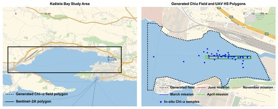
Figure 2.
Spatial extent of different polygons considered in the upscaling framework.
2.3. Hyperspectral Inversion Model
Statistical analysis of the HS data and ground-truth measurements within the study area led to the identification of an inversion algorithm that correlates the Chl- with the corresponding HS reflectance on a comparable support scale. The use of UAV HS data as an intermediary step between ground-truthing and satellite data in a complex and dynamic ecosystem has also been addressed by other studies [22,23,24]. The statistical analysis performed on the in situ samples of Chl- and UAV HS reflectance data by combining 273 spectral bands and four regression models (exponential, logarithmic, liner and rational) resulted in the best-performing inversion model, as reported in Galesic et al. [25]:
where denotes the selected water quality parameter (herein Chl-), and is the spectral wavelength variable (e.g., ), representing a functional combination of reflectance bands at i wavelengths, found to have the highest correlation with the selected parameter. The parameter denotes the measurement support scale in the parameter plane of in situ and HS data. After performing geostatistical analysis on the abundant HS data on the scale over the UAV HS data polygons (Figure 2), the spectral wavelength variable is defined in the plane and assumed to be spatially statistically homogeneous random field.
In the present case, a very high correlation () was found with the band ratio from the UAV HS data collected. The coefficients (a, b) are case-specific correlation parameters, and the parameter denotes the measurement support scale in the parameter plane of in situ and HS data.
2.4. Upscaling Technique Using Spectral Analysis
Having the inversion algorithm in (1), and realizing the extensive availability of reflectance bands from UAV HS data for each pixel within the UAV flight polygon, the task of estimating the spectrum of Chl- can be addressed. Notice that the methodology presented further applies to any functional form of the inversion algorithm found through the statistical analysis of available data.
For spatially homogeneous random fields, the covariance function depends on the differences , which are components of the lag vector . Using correlation coefficients (), the task of estimating the spectral density function of the selected water quality parameter field can be addressed. The spectral density of , denoted as , is a Fourier decomposition of its spatial variability as a function of support scale , measured by spatial wavelength , where is the wave number vector in units of rad/m (not to be confused with spectral wavelengths from sensors).
To upscale the water quality parameter spectral density function, , for any scale, (where is assumed to be a rectangle in parameter plane), we undertake the following procedure. At the scale , the quantities and in (1) are described with the Reynolds decomposition consisting of the mean and fluctuating part (e.g., and ). Then, truncating the Taylor expansion of the exponential function at the first order, and looking only at the fluctuation part, , the spectral density function (assuming second-order stationarity) is given as:
where is the spectral density function estimated from the selected band ratio of the HS dataset. The exponential spectrum model was found to have the best fit of the estimated empirical spectrum the from the band ratio. Scaling up the spectrum is a local average at some new scale , which can be obtained by applying a corresponding Bartlett filter [26] to the point scale .
From (3), it is clear that, when and are approaching zero, we obtain (2). The obtained spectrum of the reflectance band ratio, is at the support scale , which results from the drone’s flight altitude, not at the point scale . Since the HS data are themselves a local average over the support scale , the spectrum is assumed to be truncated at the Nyquist (maximum) wave number , yielding:
Using (4) in (3), the upscaled spectral density function of the selected water quality parameter field, for , follows from:
The above spectrum, , describes the variability distribution in the wave number domain of the Chl- field at spatial scale B. When , Equation (2) is recovered.
The total variance of the upscaled random field can be expressed as a function of . When normalized, it represents the variance function of the random field highlighting the non-linear reduction in the process variance due to upscaling. The calculated normalized variance function shows a 15% decrease from a few centimeters in the UAV HS data to 20 meters (Sentinel-2A sensor data). The spatial scale is chosen to match the availability of the eight bands of the Sentinel-2A sensor at this resolution.
The upscaling procedure began with an initial step, where the collected UAV HS data were used to estimate the inversion algorithm from Chl- in situ measurements in (1). The spectrum was evaluated from the selected band ratio for each measurement campaign by taking the Fourier transform of , extracting its amplitude, and squaring it. The reflectance spectrum from the HS data then yielded the Chl- spectrum in (2), which was upscaled to the Chl- spectrum using Equation (5).
The development of (5) provides a means of expressing the water quality parameter field and its spectrum, derived from the correlated UAV HS–in situ matching pairs, at any desired support scale. The choice of scale B should be made to match the spatial scale of the selected satellite sensor, which covers much larger coastal areas. A similar procedure for one-dimensional spectral upscaling was originally proposed by [27] for geoelectric–hydraulic conductivity correlation in aquifers, facilitating the generation of a hydraulic conductivity field on a larger scale suitable for regional numerical modeling of flow and transport in porous media.
In this study, upscaling is employed to improve the inversion algorithms for satellite data by aligning them with the comparable spatial scale of water quality parameters. For each monitoring session, conditional realizations of Chl- values are generated on the selected random field polygon (Figure 2). Each realization is conditioned on available in situ Chl- samples within the UAV HS polygon. The averaged realization for each session is then used to estimate the inversion algorithm from the Sentinel-2A multispectral reflectance data, based on the satellite–pseudo data matching pairs. The described methodology is illustrated in the flowchart in Figure 3.
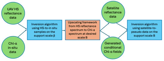
Figure 3.
Flowchart of implemented framework.
3. Results
3.1. Generating Random Chl- Fields
To generate a random field with a known spectrum, the procedure involves generating complex Fourier coefficients with random phases and amplitudes. The spectral density function is discretized over the wave vector domain . For each wave vector, a Fourier coefficient is constructed with a magnitude and a uniformly distributed random phase , ensuring Hermitian symmetry for a real-valued field. The inverse Fourier transform is then applied to these coefficients to obtain the spatial random Chl- field. This method ensures that the generated field matches the prescribed spectral characteristics while maintaining statistical stationarity. These calculations together with statistical analysis for validation, and all graphical presentations, are performed using Mathematica (Wolfram Research, Inc., Champaign, IL, USA, Version 14.1).
The generated conditional Chl- field contains a large number of points within the selected polygon, enabling the exploration of a much wider range of satellite reflectance data. The averaged realization, based on conditional realizations of Chl- fields, is used to estimate the inversion algorithm from satellite reflectance data on the same support scale B. Figure 4 compares the averaged realization of conditionally generated random Chl- fields with the actual in situ samples for each season. As expected, the generated data on the support scale B exhibit smaller variability due to the larger support scale, while maintaining the spatial correlation structure and preserving the mean value of the in situ Chl- samples.
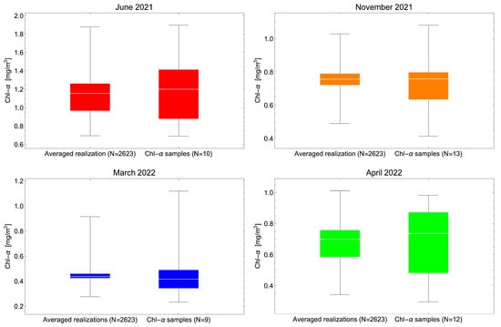
Figure 4.
Box plot showing Chl- range between the averaged realization of random fields and available in situ Chlα samples for each monitoring session.
3.2. Inversion Algorithms Designed from Generated Chl- Fields
The coastal water considered in this study has oligotrophic characteristics, with Chl- predominantly ranging between 0 and 3 mg/m3. The weak phytoplankton signal requires careful selection of Sentinel-2A bands to minimize interference from colored dissolved organic matter (CDOM) and pure water absorption. For this type of marine environment, the most commonly used bands are B2 (490 nm, blue), B3 (560 nm, green), B4 (665 nm, red), and B5 (705 nm, red-edge), along with their combinations [28,29,30]. The other bands from the Sentinel-2A multispectral instrument are less effective for oligotrophic waters and low Chl- values due to negligible Chl- absorption and the dominance of CDOM and other water signals.
Many different band-ratio-based inversion algorithms have been used to estimate Chl- concentrations from satellite remote sensing. In this study, the focus is on the blue, green, and red band ratio combinations from the radiometric resolution of the Sentinel-2A multispectral sensor, which are suitable for oligotrophic low Chl- values and medium turbidity. The selected list of inversion models and band combinations, including the Normalized Difference Chlorophyll Index (NDCI) [31], is presented in Table 1.

Table 1.
List of inversion models and band combinations considered in this study.
Through a comparative analysis of different inversion models, Figure 5 displays the best-performing models applied to the averaged conditionally generated random Chl- field and the corresponding band combinations (black line). In addition, Figure 5 also presents the best-performing algorithm when applied directly to the in situ samples (dashed blue line). The statistical indicators used in this study for performance assessment are the coefficient of determination () and the root mean square error (RMSE).
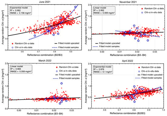
Figure 5.
The best-performing algorithms for each monitoring session: inversion algorithm after upscaling (black line) and inversion directly from in situ Chl- samples (dashed blue line).
Figure 5 shows that the inversion algorithms are calibrated over a much wider range of Sentinel-2A reflectance data compared to the available range of Chl- samples. The direct inversion of Chl- in situ samples in Figure 5) with satellite bands may easily cause over- or underestimation of attribute values for the lower and higher ranges of reflectance band combinations present within the selected satellite polygon. Using the satellite data with the generated parameter field, at a comparable support scale, ensures the stability and improved performance of the inversion.
For the productive spring and summer periods in the selected study area, the best performance was found with the exponential model and the band ratio . During the less productive periods with a narrower range of Chl- values, the linear model with the band difference showed the highest statistical performance. This is because during autumn and winter in Kaštela Bay, the inherent optical properties captured by satellite bands are insufficient to detect the very narrow range of Chl- values present in the coastal waters.
3.3. Validation of Selected Inversion Models
According to the validation analysis of the best-performing inversion models Figure 6 presents the scatter plots of measured and predicted Chl- values. Figure 6a displays the overall scatter plot of four measurement campaigns, showing Chl- in situ samples and their predicted values when inversion models (dashed blue inversion models from Figure 5) are applied directly to the in situ data without the upscaling procedure. The coefficient of determination is 0.51, and the RMSE is 0.185 mg/m3, indicating that the inversion algorithms designed from in situ measurements lack sufficient stability and applicability in the study area. The reason is in the limited data and insufficient spatial coverage as ground truth identification needs to be aligned with relatively small UAV HS polygons.
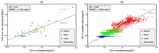
Figure 6.
The validation results of Chl- in situ data (a) and generated data (b), with inversion values from selected models.
On the other hand, Figure 6b shows the same type of validation but with the generated Chl- data over much larger polygon using the upscaling procedure. Each selected best-performing model from Figure 5 is used to obtain the Chl- modeled values. With a coefficient of determination of 0.86 and an RMSE of 0.096 mg/m3, the inversion model applied to the generated Chl- data demonstrates significantly improved stability and better applicability for predicting Chl- concentrations in the Kaštela Bay.
3.4. Chlorophyll- Mapping in the Kaštela Bay
Using the best-performing inversion models for Chl- prediction derived from the selected polygon of generated data and combining them with the concurrent acquisition of Sentinel-2A satellite data, the Chl- inversion map is displayed in Figure 7. Chl- mapping is presented for each monitoring session of the Kaštela Bay region covered with Sentinel-2A sensor overpass. The results show the annual variation of Chl- values, with higher concentrations during spring (April) and summer (June) periods when Kaštela Bay is more productive, compared to winter (March) and autumn (November).
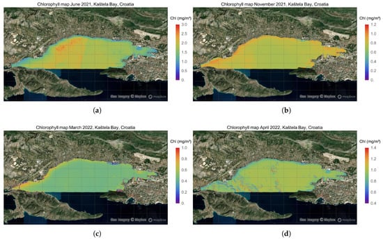
Figure 7.
Chlorophyll- mapping in Kaštela Bay for each monitoring session: (a) June 2021. (b) November 2021. (c) March 2022. (d) April 2022.
The highest Chl- concentrations are located in the western part of Kaštela Bay, where water exchange is slower, particularly during the productive summer season and periods of elevated temperatures. Furthermore, Figure 8 illustrates the vertical histogram density of Chl- concentrations across the four monitoring sessions, showing predominant values around 0.5 mg/m3 in winter and 0.8 mg/m3 in autumn. In contrast, during the more productive periods with heightened biomass growth, the Chl- range is 0.5–1.5 mg/m3 in spring and 1–2.5 mg/m3 in summer.

Figure 8.
Vertical histogram densities of predicted Chl- values in the Kaštela Bay for each monitoring session.
The inversion model of Sentinel-2A data for April 2021 indicates spatial heterogeneity in Chl- values, demonstrating an apparent increase in spatial gradients at the beginning of the productive period. After the summer period, Chl- concentrations are predominantly uniform across the bay, apart from the narrow coastal areas where concentrations are slightly higher due to the wet season and significant surface runoff discharging into Kaštela Bay.
4. Discussion
Kaštela Bay is a semi-enclosed coastal area where the karstic river Jadro discharges into the sea, exhibiting the characteristics of a moderately productive coastal zone. Consequently, the Chl- mapping revealed a clear distinction between low productivity during autumn and winter and heightened productivity in spring and summer. Seasonal variations in surface runoff, particularly during autumn and winter, combined with inadequately treated wastewater discharges, contribute to nutrient loading in Kaštela Bay. However, detecting the spatial and temporal variability of these water quality parameters is challenging due to the low-frequency spatial coverage from the monitoring program regularly conducted by the Croatian Water Agency.
The upscaling procedure applied in this study addresses the limitation of sparse in situ measurements by generating additional pseudo-measurements. This approach enhances the performance of satellite-based inversion models while preserving the spatial structure and mean value of the actual in situ data. The results indicate that Kaštela Bay experiences two distinct periods of biomass productivity that directly affect the predicted Chl- concentrations throughout the bay; while Chl- concentrations remain relatively low during autumn and winter, the combined effect of increased runoff and nutrient loading establishes the conditions for a surge in biomass productivity during spring and summer. This seasonal pattern is evident in Figure 7, where elevated Chl- concentrations are observed along the narrow coastline and at the Jadro River estuary. These elevated concentrations gradually enrich the bay with nutrients and wastewater discharges, setting the stage for pronounced biomass productivity during the warmer months. Climate change, with its effects of rising temperatures and increasingly dry summers, further amplifies these nutrient-enriched zones of high Chl- values during late spring and summer. This effect is especially notable in the western part of Kaštela Bay, where a narrow and shallow strait restricts exchange with the open Adriatic Sea.
The inversion of the available Sentinel-2A data for the April 2021 campaign revealed some spatial variability in Chl- values predominantly in the western part of the satellite polygon. This small-scale variability likely arises from the presence of clouds and their shadow artifacts during the April satellite overpass. However, a highly dynamic productivity period occurring in Kaštela Bay at the onset of the productive season could also result in increased Chl- variability, underscoring the necessity for more frequent and spatially dense in situ monitoring campaigns.
The results demonstrate that the upscaling framework, which integrates airborne hyperspectral imagery and in situ sampling with satellite data, yields water quality retrievals that align well with the generated pseudo-measurements. This approach enhances the inversion process by augmenting limited ground-truth data, thereby improving satellite-based retrievals and facilitating more accurate regional mapping of water quality parameters. These findings highlight the potential of the presented methodology to overcome data scarcity challenges in coastal water monitoring, ultimately supporting the better-informed management of these ecologically sensitive areas.
5. Conclusions
The monitoring programs typically available for coastal areas and estuaries often rely on sampling sessions that provide only snapshots of water quality parameters in both space and time. Given the complex and dynamic hydrodynamics of these marine environments, it is appropriate to consider water quality parameters as random fields. In this study, we present an upscaling framework that generates multiple realizations of biogeochemical parameters as new pseudo-measurements, serving two key purposes. First, it increases the number of probable concentrations of the selected parameter, enriching the dataset. Second, it enables the exploration of a broader range of satellite data combinations for robust regional inversion modeling. In the Kaštela Bay study area, sparse in situ data are complemented by the generated parameter fields, facilitating the development of reliable inversion algorithms using satellite–pseudo data matching pairs at the same spatial scale.
This study demonstrates how, with the current accessibility of UAV-based hyperspectral (HS) data, upscaling can be effectively implemented to create multiple realizations of water quality parameters that are consistent with the spatial scale of satellite remote sensing data. This approach enhances the design and application of inversion algorithms on a regional scale, providing detailed mapping of coastal water quality. While the inversion models exhibited strong performance, further research should explore the temporal and spatial frequency of hyperspectral data acquisitions needed to accurately capture the dynamic nature of regional coastal waters. Additionally, future studies should explore the temporal and spatial frequency of hyperspectral data acquisitions needed to accurately capture the dynamic nature of regional coastal waters.
The findings of this study also have practical significance for the implementation of the European Water Framework Directive [32] and the Marine Strategy Framework Directive [33], both issued by the European Commission. A major challenge in achieving the ecological status assessments required by these directives is the limited availability of high-quality in situ data [34]. The upscaling framework presented here offers a promising approach to address these data limitations, supporting more comprehensive and reliable monitoring and management of coastal and marine environments. Overall, the integration of UAV hyperspectral data, satellite observations, and statistical upscaling approaches represents a significant step forward in the application of remote sensing for regional water quality assessment and management.
Funding
This research was partially funded by project STIM-REI, Contract Number: KK.01.1.1.01. 0003, funded by the European Union through the European Regional Development Fund, the Operational Programme Competitiveness and Cohesion 2014–2020 (KK.01.1.1.01), and by projekt COMON (Coastal zone monitoring using multi-scaling methods) funded by European Union from European Structural and Investment Funds 2014–2020, Contract Number: KK.01.1.1.07.0033.
Data Availability Statement
The data are available from the author on reasonable request.
Acknowledgments
The author is thankful to Morena Galešić-Divić for providing the UAV HS and Sentinel-2A datasets and discussing the earlier version of the manuscript.
Conflicts of Interest
The author declares no conflict of interest.
Abbreviations
The following abbreviations are used in this manuscript:
| UAV | unmanned aerial vehicle |
| HS | hyperspectral |
| RMSE | root mean square error |
| Chl- | Chlorophyll- |
| CDOM | colored dissolved organic matter |
| NDCI | Normalized Difference Chlorophyll Index |
| ESA | European Space Agency |
References
- Lavigne, H.; Zande, D.; Ruddick, K.; Santos, J.; Gohin, F.; Brotas, V.; Kratzer, S. Quality-Control Tests for OC4, OC5 and NIR-Red Satellite Chlorophyll-a Algorithms Applied to Coastal Waters. Remote Sens. Environ. 2021, 255, 112237. [Google Scholar] [CrossRef]
- Groom, S.; Sathyendranath, S.; Ban, Y.; Bernard, S.; Brewin, R.; Brotas, V.; Brockmann, C.; Chauhan, P.; Choi, J.; Chuprin, A. Satellite Ocean Colour: Current Status and Future Perspective. Front. Mar. Sci. 2019, 6, 485. [Google Scholar] [CrossRef] [PubMed]
- Kurylyk, B.L.; Smith, K.A. Stuck in the middle: Thermal regimes of coastal lagoons and estuaries in a warming world. Environ. Res. Lett. 2023, 18, 61003. [Google Scholar] [CrossRef]
- Callejas, I. Monitoring coastal water quality with satellite data. Nat. Rev. Earth Environ. 2022, 3, 553–556. [Google Scholar] [CrossRef]
- Feng, I.; Chuanmin Hu, C.; Li, J. Can MODIS Land reflectance Products be Used for Estuarine and Inland Waters. Water Resour. Res. 2018, 54, 3583–3601. [Google Scholar] [CrossRef]
- Jang, W.; Kim, J.; Kim, J.H.; Shin, J.K.; Chon, K.; Kang, E.T.; Park, Y.; Kim, S. Evaluation of Sentinel-2 Based Chlorophyll-a Estimation in a Small-Scale Reservoir: Assessing Accuracy and Availability. Remote Sens. 2024, 16, 315. [Google Scholar] [CrossRef]
- Vantrepotte, V.; Loisel, H.; Dessailly, D.; Mériaux, X. Optical Classification of Contrasted CoastalWaters. Remote Sens. Environ. 2012, 123, 306–323. [Google Scholar] [CrossRef]
- Ibrahim, A.; Franz, B.; Ahmad, Z.; Healy, R.; Knobelspiesse, K.; Gao, B.-C.; Proctor, C.; Zhai, P.-W. Atmospheric correction for hyperspectral ocean color retrieval with application to the hyperspectral imager for the Coastal Ocean (HICO). Remote Sens. Environ. 2018, 204, 60–75. [Google Scholar] [CrossRef]
- O’Shea, R.E.; Pahlevan, N.; Smith, B.; Bresciani, M.; Egerton, T.; Giardino, C.; Li, L.; Moore, T.; Ruiz-Verdu, A.; Ruberg, S.; et al. Advancing cyanobacteria biomass estimation from hyperspectral observations: Demonstrations with HICO and PRISMA imagery. Remote Sens. Environ. 2021, 266, 112693. [Google Scholar] [CrossRef]
- Ryan, E.O.; Pahlevan, N.; Smith, B.; Boss, E.; Gurlin, D.; Alikas, K.; Kangro, K.; Kudela, R.M.; Vaiciute, D. A hyperspectral inversion framework for estimating absorbing inherent optical properties and biogeochemical parameters in inland and coastal waters. Remote Sens. Environ. 2023, 225, 113706. [Google Scholar] [CrossRef]
- Ma, T.; Zhang, D.; Li, X.; Huang, Y.; Zhang, L.; Zhu, Z.; Sun, X.; Lan, Z.; Guo, W. Hyperspectral remote sensing technology for water quality monitoring: Knowledge graph analysis and Frontier trend. Front. Environ. Sci. 2023, 11, 1133325. [Google Scholar] [CrossRef]
- Jeong, B.; Lee, S.; Heo, J.; Lee, J.; Lee, M.-J. Deep Learning-Based Retrieval of Chlorophyll-a in Lakes Using Sentinel-1 and Sentinel-2 Satellite Imagery. Water 2025, 17, 1718. [Google Scholar] [CrossRef]
- Chusnah, W.N.; Chu, H.-J.; Jaelani, L.M. Machine-learning-estimation of high-spatotemporal resolution chlorophyll-a concentration using multi-satellite imagery. Sustain. Environ. Res. 2023, 33, 11. [Google Scholar] [CrossRef]
- Assaf, M.N.; Abdelal, Q.; Hussein, N.M.; Halaweh, G.; Alzubaldi, A.J. Water quality monitoring and management: Integration of machine learning algorithms and Sentinel-2 images for the estimation of Chlorophyll-a. Model. Earth Syst. Environ. 2025, 11, 348. [Google Scholar] [CrossRef]
- Loisel, H.; Vantrepotte, V.; Ouillon, S.; Ngoc, D.D.; Herrmann, M.; Tran, V.; Mériaux, X.; Dessailly, D.; Jamet, C.; Duhaut, T.; et al. Assessment and Analysis of the Chlorophyll-a Concentration Variability over the Vietnamese CoastalWaters from the MERIS Ocean Color Sensor (2002–2012). Remote Sens. Environ. 2017, 190, 217–232. [Google Scholar] [CrossRef]
- Defoin-Platel, M.; Chami, M. How ambiguous is the inverse problem of ocean color in coastal waters? J. Geophys. Res. 2007, 112, C03004. [Google Scholar] [CrossRef]
- Pasarić, M.; Orlić, M. Meteorological forcing of the Adriatic: Present vs. projected climate conditions. Geofizika 2004, 21, 69–87. [Google Scholar]
- Andricevic, R.; Kekez, T.; Vojkovic, M. Trophic status assessment of Central Eastern Adriatic Sea using water quality variables and loading capacity concept for estuaries. Mar. Pollut. Bull. 2021, 173 Pt B, 113126. [Google Scholar] [CrossRef]
- Marasovic, I.; Pucher-Petkovic, T. Eutrophication impact on the species composition in a natural phytoplankton community. Acta Adriat. 1991, 32, 719–729. [Google Scholar]
- Andricevic, R. Ecological quality assessment under uncertainty for transitional and coastal waters: Central Easter Adriatic Sea study. Ecol. Indic. 2022, 138, 1735–1746. [Google Scholar] [CrossRef]
- Sola, I.; García-Martín, A.; Sandonís-Pozo, L.; Álvarez-Mozos, J.; Pérez-Cabello, F.; González-Audícana, M.; Montorio Llovería, R. Assessment of atmospheric correction methods for Sentinel-2 images in Mediterranean landscapes. Int. J. Appl. Earth Obs. Geoinf. 2018, 73, 63–76. [Google Scholar] [CrossRef]
- Yang, Z.; Yu, X.; Dedman, S.; Rosso, M.; Zhu, J.; Yang, J.; Xia, Y.; Tian, Y.; Zhang, G.; Wang, J. UAV remote sensing applications in marine monitoring: Knowledge visualization and review. Sci. Total Environ. 2022, 838, 155939. [Google Scholar] [CrossRef] [PubMed]
- Wójcik, K.A.; Bialik, R.J.; Osinska, M.; Figielski, M. Investigation of Sediment-Rich glacial meltwater plumes using a high-resolution multispectral sensor mounted on an unmanned aerial vehicle. Water 2019, 11, 2405. [Google Scholar] [CrossRef]
- Medvedev, A.; Telnova, N.; Alekseenko, N.; Koshkarev, A.; Kuznetchenko, P.; Asmaryan, S.; Narykov, A. UAV-derived data application for environmental monitoring of the coastal area of Lake Sevan, Armenia with a changing water level. Remote Sens. 2020, 12, 3821. [Google Scholar] [CrossRef]
- Galešić Divić, M.; Kvesić Ivanković, M.; Divić, V.; Kišević, M.; Panić, M.; Lugonja, P.; Crnojević, V.; Andričević, R. Estimation of Water Quality Parameters in Oligotrophic Coastal Waters Using Uncrewed-Aerial-Vehicle Obtained Hyperspectral Data. J. Mar. Sci. Eng. 2023, 11, 2026. [Google Scholar] [CrossRef]
- Vanmarcke, E. Random Fields: Analysis and Synthesis; Revised and Expanded New Edition; World Scientific Publishing: Singapore, 2010. [Google Scholar]
- Purvanve, T.D.; Andricevic, R. Geoelectric characterization of the hydraulic conductivity field and its spatial structure at variable scales. Water Resour. Res. 2000, 36, 2915–2924. [Google Scholar] [CrossRef]
- Talavera, L.; Domínguez-Gómez, J.A.; Navarro, N.; Rodríguez-Santalla, I. Analysing Spatiotemporal Variability of Chlorophyll-a Concentration and Water Surface Temperature in Coastal Lagoons of the Ebro Delta (NW Mediterranean Sea, Spain). J. Mar. Sci. Eng. 2024, 12, 941. [Google Scholar] [CrossRef]
- Tran, M.D.; Vantrepotte, V.; Loisel, H.; Oliveira, E.N.; Tran, K.T.; Jorge, D.; Mériaux, X.; Paranhos, R. Band Ratios Combination for Estimating Chlorophyll-a from Sentinel-2 and Sentinel-3 in Coastal Waters. Remote Sens. 2023, 15, 1653. [Google Scholar] [CrossRef]
- Zhanga, W.; Huanga, R.; Dengc, S.; Wanga, W.; Wanga, Y. Spatio-temporal distribution of sea surface chlorophyll-a in coral reefs of the South China Sea over the past decade based on Landsat-8 OLI images. Sci. Total Environ. 2024, 935, 173433. [Google Scholar] [CrossRef]
- Mishra, S.; Mishra, D.R. Normalized difference chlorophyll index: A novel model for remote estimation of chlorophyll-a concentration in turbid productive waters. Remote Sens. Environ. 2012, 117, 394–406. [Google Scholar] [CrossRef]
- European Commission. Directive 2000/60/EC of the European Parliament and of the Council Establishing a Framework for Community Action in the Field of Water Policy; European Commission: Brussels, Belgium, 2000. [Google Scholar]
- European Commission. Directive 2008/56/EC of the European parliament and of the council. Off. J. Eur. Union 2008, 164, 19–40. [Google Scholar]
- Santos, J.I.; Vidal, T.; Goncalves, F.J.; Castro, B.B.; Pereira, J.L. Challenges to water quality assessment in Europe; Is there scope for improvement of the current Water Framework Directive bioassessment scheme in rivers? Ecol. Indic. 2021, 121, 107030. [Google Scholar] [CrossRef]
Disclaimer/Publisher’s Note: The statements, opinions and data contained in all publications are solely those of the individual author(s) and contributor(s) and not of MDPI and/or the editor(s). MDPI and/or the editor(s) disclaim responsibility for any injury to people or property resulting from any ideas, methods, instructions or products referred to in the content. |
© 2025 by the author. Licensee MDPI, Basel, Switzerland. This article is an open access article distributed under the terms and conditions of the Creative Commons Attribution (CC BY) license (https://creativecommons.org/licenses/by/4.0/).