Soil Conservation Measures on Degraded Land in the Hilly Region of Eastern Romania: A Case Study from Puriceni-Bahnari Catchment


Abstract
:1. Introduction
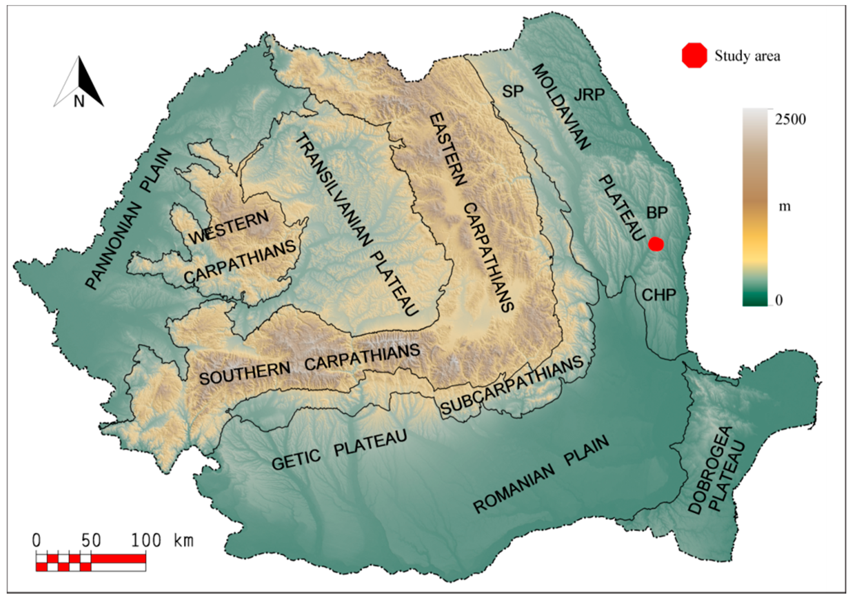
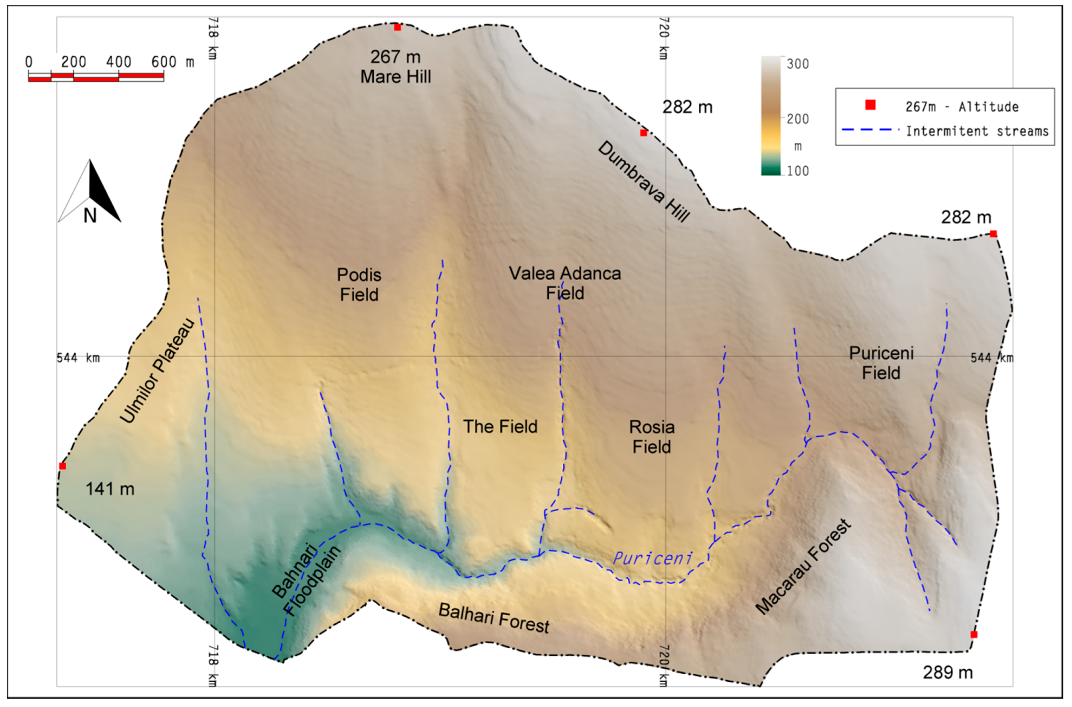
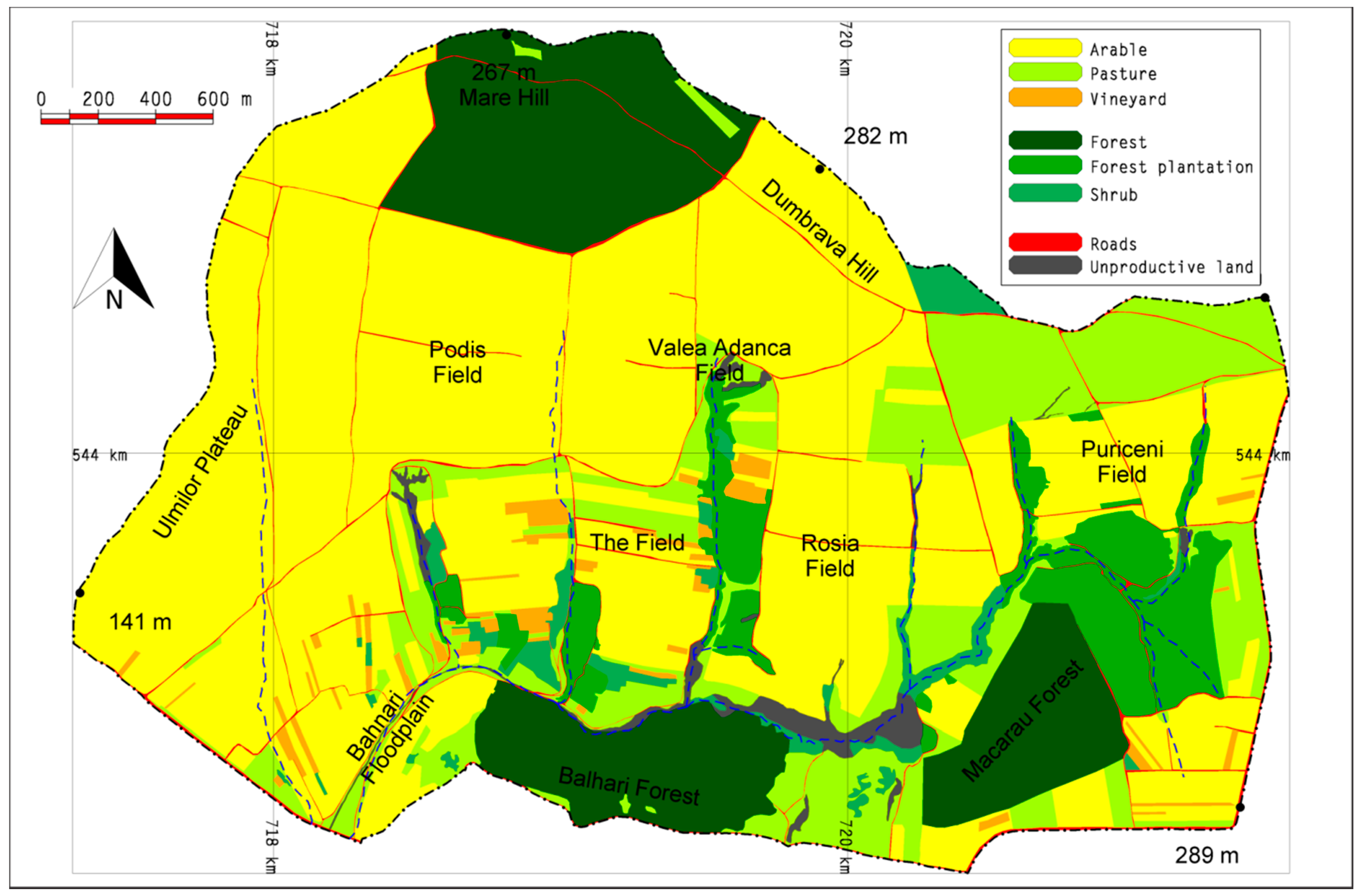
2. Study Area
3. Methods
4. Results and Discussion
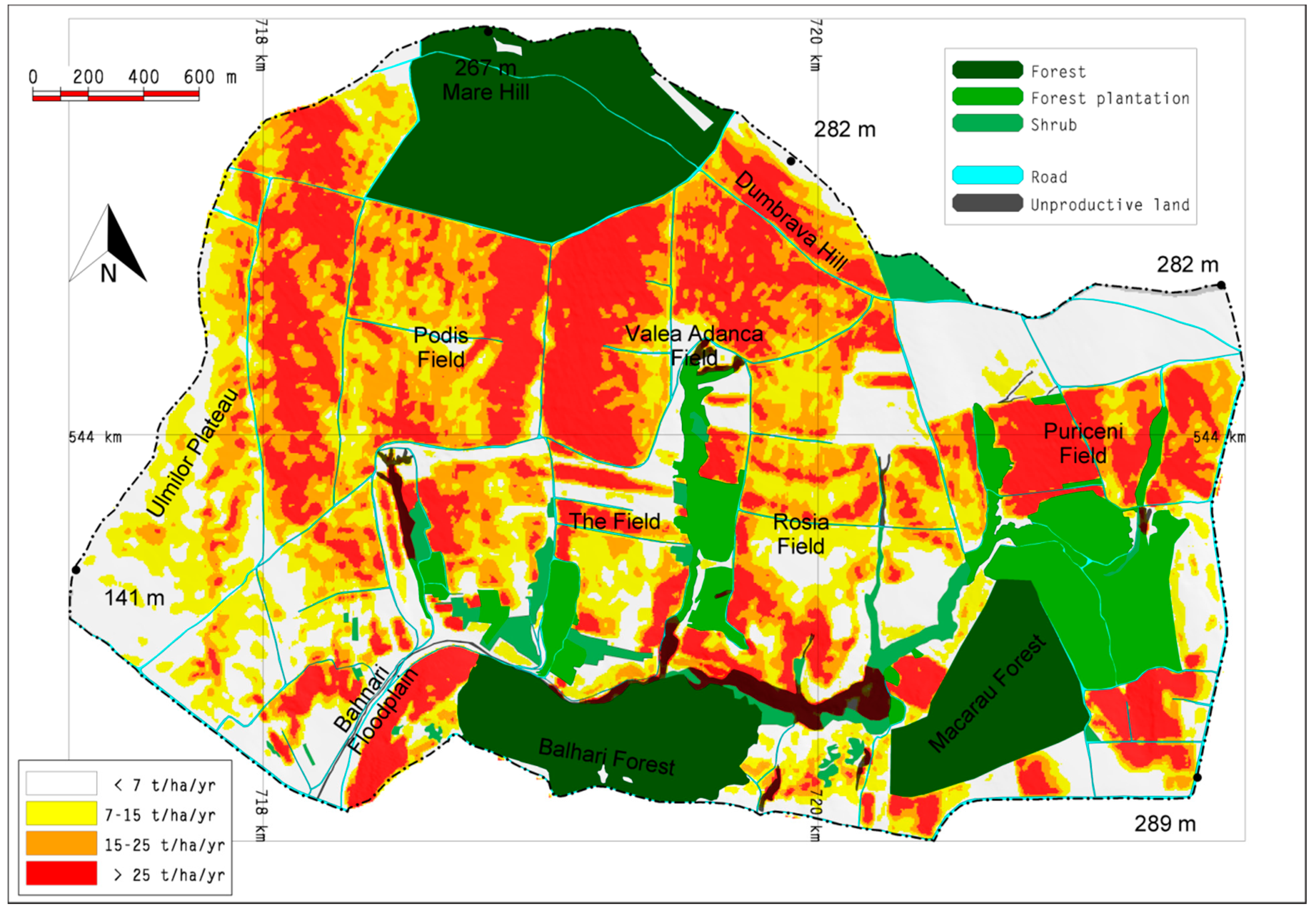
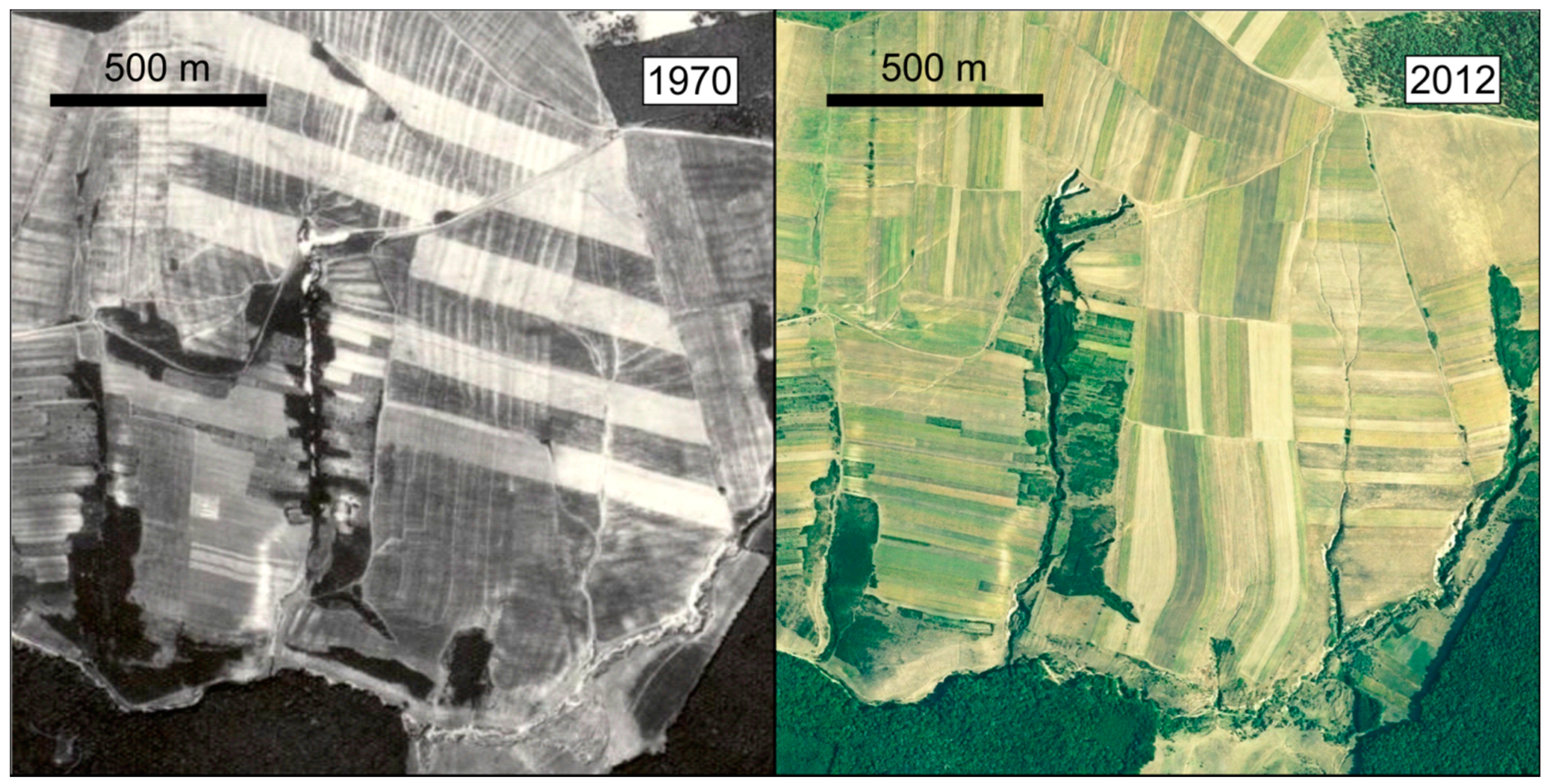
4.1. Land Degradation
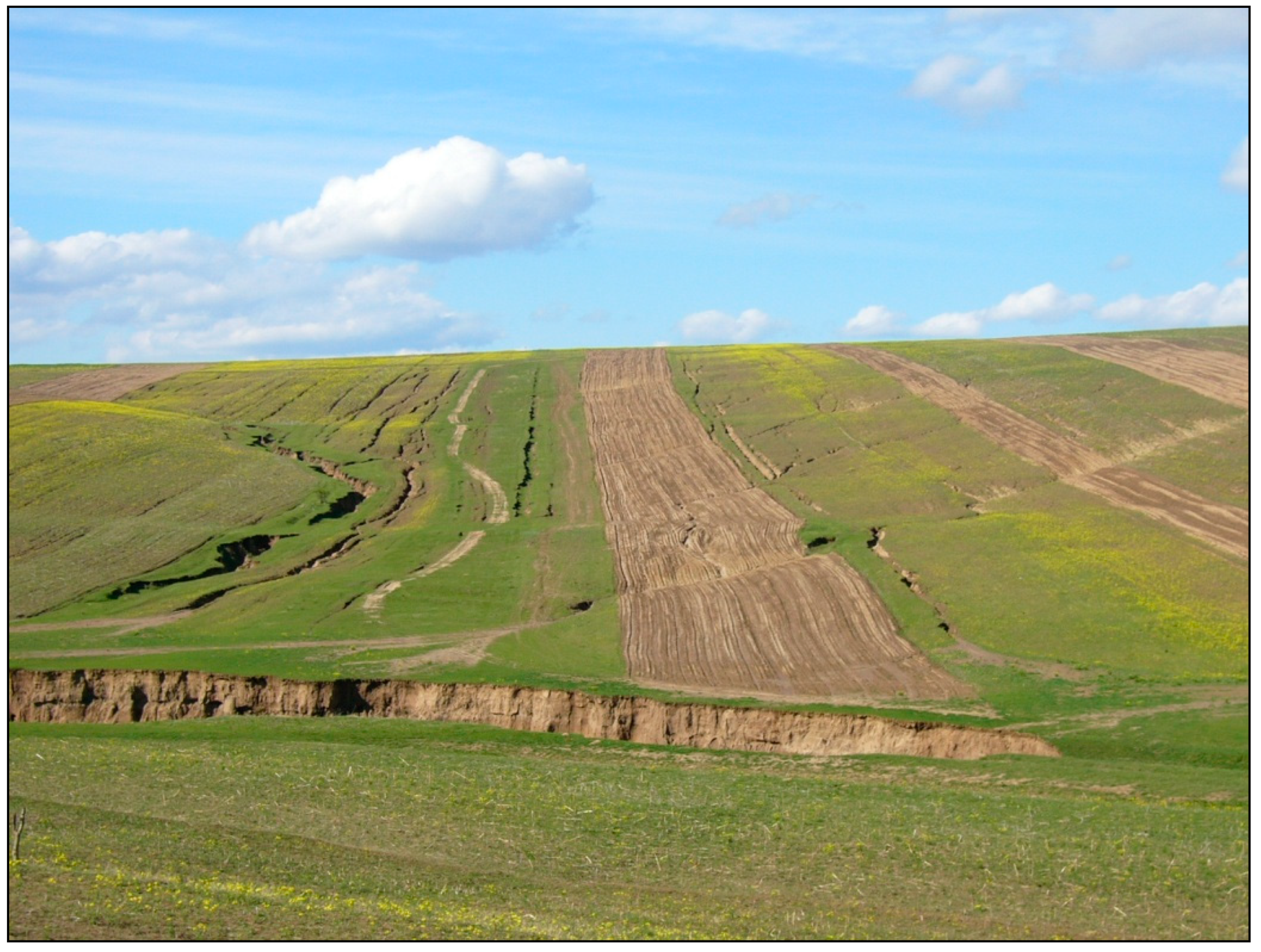
4.1.1. Soil Erosion
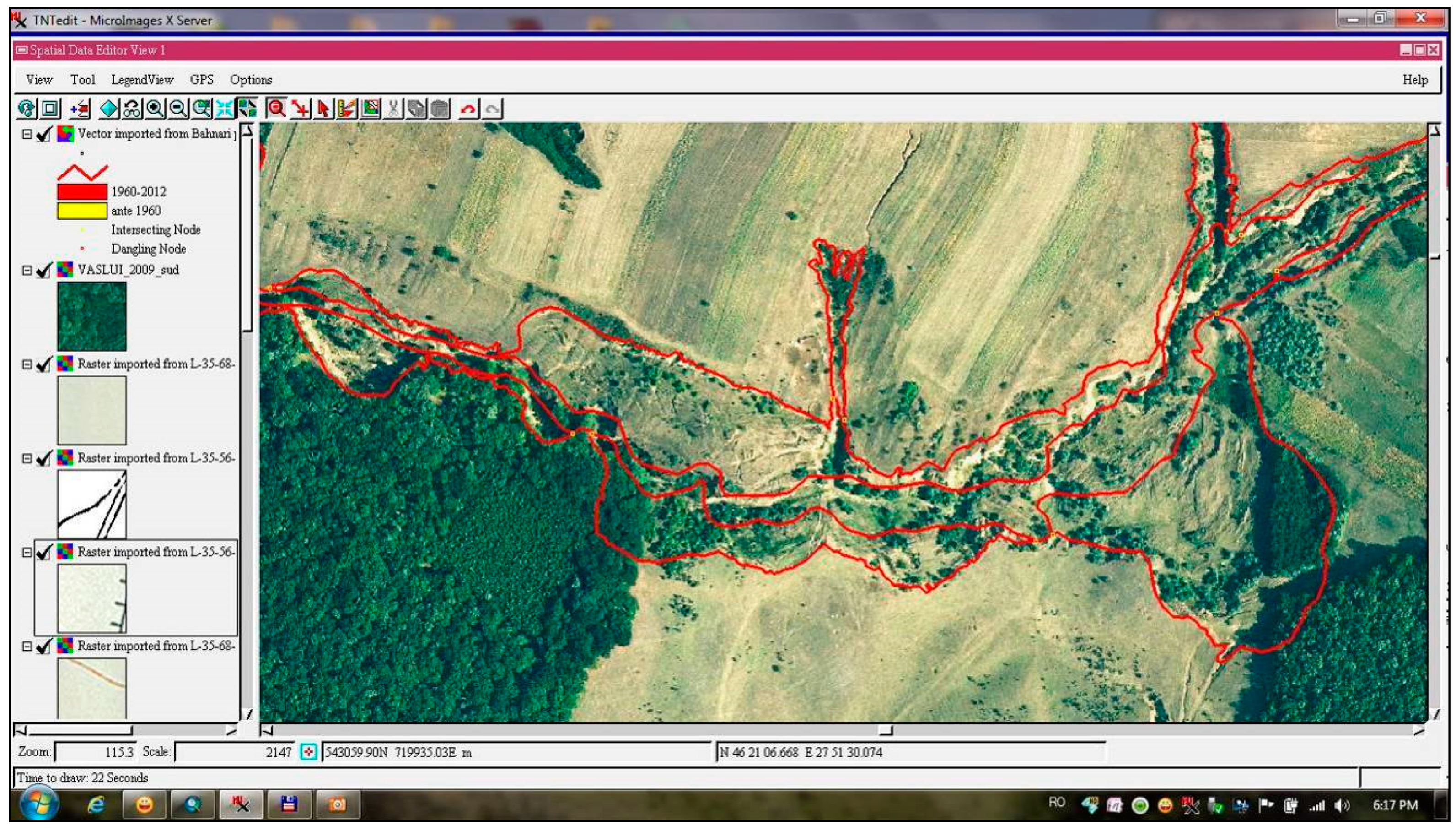
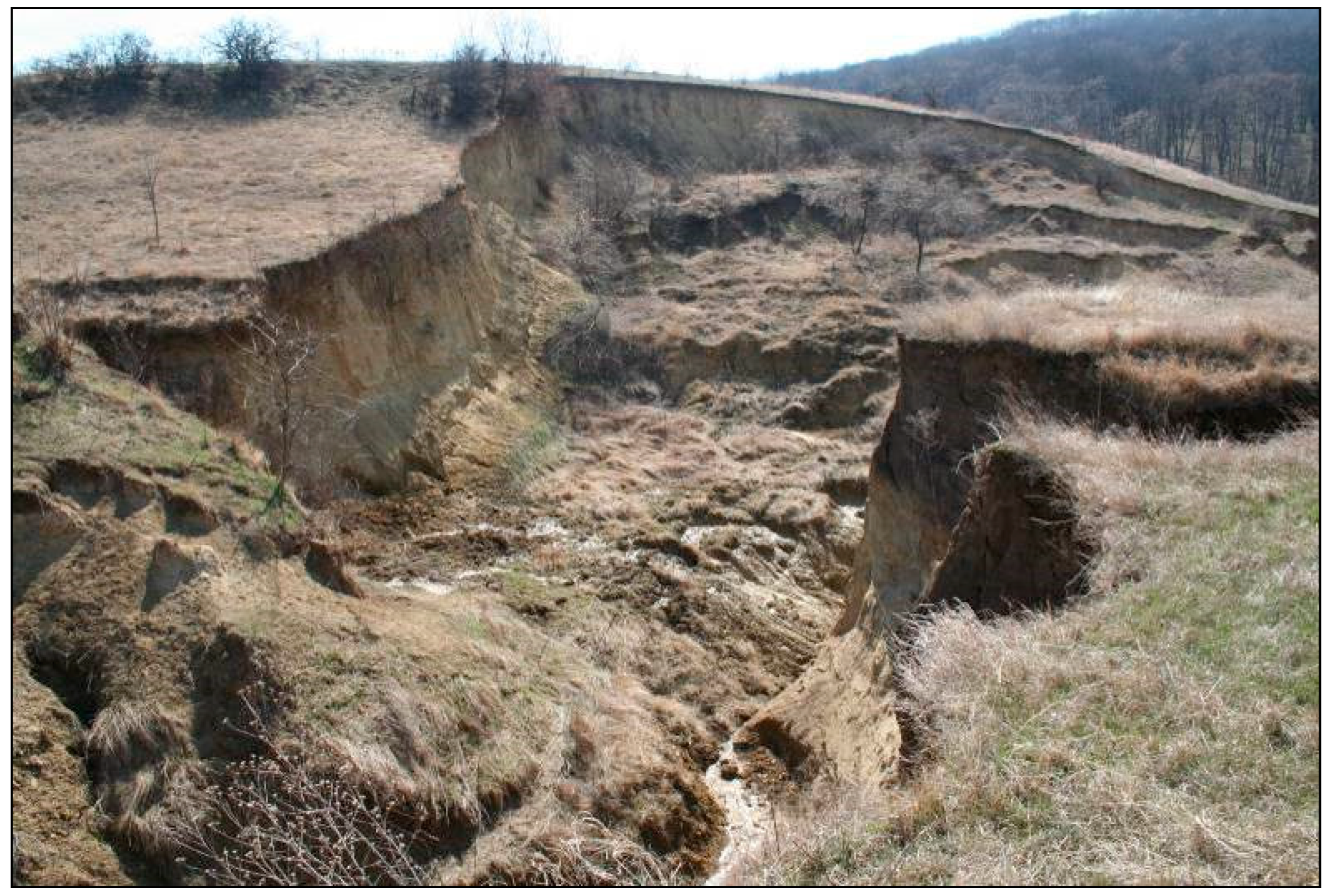
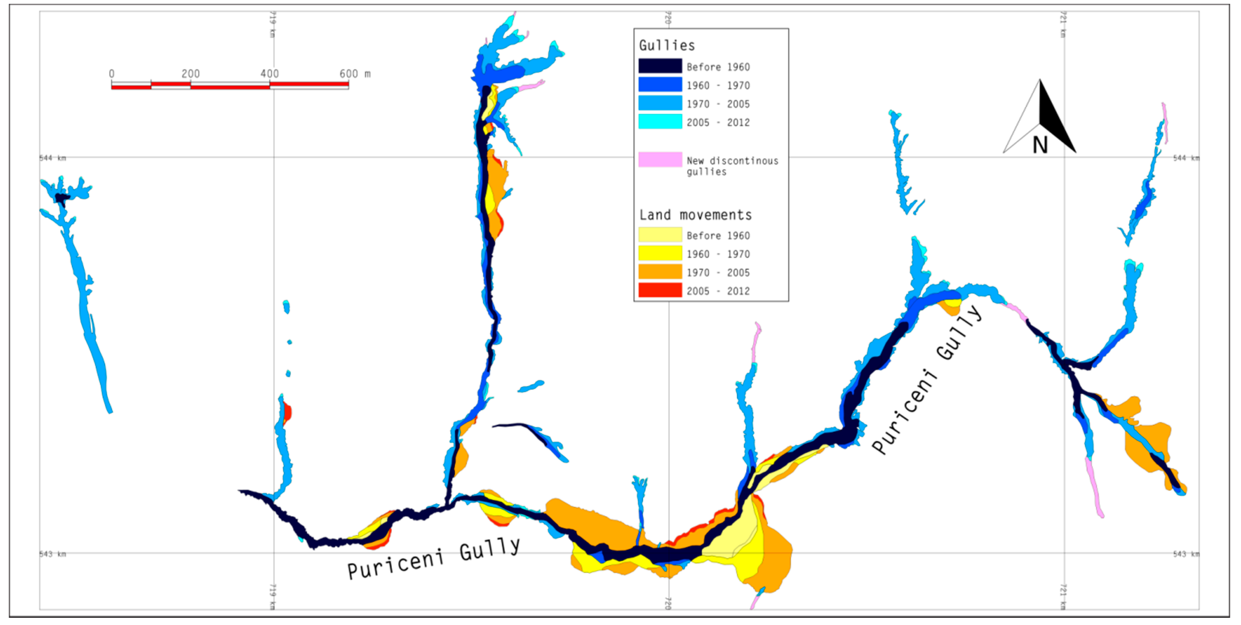
4.1.2. Gully Erosion
- -
- Stage 1: represented by incipient small discontinuous gullies, as in gullies situated in the field area;
- -
- Stage 2: discontinuous evolved gullies, as in gullies in the area of the main peak (Puriceni Field);
- -
- Stage 3: continuous valley-side gullies that have “embedded” old discontinuous gullies, as in the gullies in the Valea Adanca Field;
- -
- Stage 4: continuous evolved gullies on valley bottoms developed on the main valley, as in the Puriceni catchment.
4.1.3. Landslides
4.2. Evolution of Soil Conservation Measures
- log. L = 2.22 − 0.03·i (for soils resistant to erosion);
- log. L = 2.15 − 0.03·i (for soils with a middle resistance to erosion);
- log. L = 2.05 − 0.03·i (for soils that slightly resist erosion).
5. Conclusions
Author Contributions
Funding
Institutional Review Board Statement
Informed Consent Statement
Acknowledgments
Conflicts of Interest
References
- Savu, P.; Bucur, D. Agricultural Land Planning with Land Improvement Work; Ion Ionescu de la Brad University Publishing House: Iasi, Romania, 2002. [Google Scholar]
- Poesen, J. Soil erosion in the Anthropocene: Research needs. Earth Surf. Processes Landf. 2018, 43, 64–84. [Google Scholar] [CrossRef]
- Brown, L.R. Global Issues of Humanity; Technical Publishing House: Bucharest, Romania, 1988. [Google Scholar]
- Posthumus, H.; Deeks, L.K.; Rickson, R.J.; Quinton, J.N. Costs and benefits of erosion control measures in the UK. Soil Use Manag. 2015, 31, 16–33. [Google Scholar] [CrossRef]
- Bucur, D.; Jitareanu, G.; Ailincai, C.; Tsadilas, C.; Mercus, A. Influence of soil erosion on water, soil, humus and nutrient losses in different crop systems in the Moldavian Plateau, Romania. J. Food Agric. Environ. 2007, 5, 261–264. [Google Scholar]
- Ionita, I. Applied Geomorphology (Degradation Processes of Hilly Regions); Alexandru Ioan Cuza University of Iasi Publishing House: Iasi, Romania, 2000; p. 248. [Google Scholar]
- Guo, Y.; Peng, C.; Zhu, Q.; Wang, M.; Wang, H.; Peng, S.; He, H. Modelling the impacts of climate and land use changes on soil water erosion: Model applications, limitations and future challenges. J. Environ. Manag. 2019, 250, 109403. [Google Scholar] [CrossRef]
- Li, P.; Zang, Y.; Ma, D.; Yao, W.; Holden, J.; Irvine, B.; Zhao, G. Soil erosion rates assessed by RUSLE and PESERA for a Chinese Loess Plateau catchment under land-cover changes. Earth Surf. Process. Landf. 2020, 45, 707–722. [Google Scholar] [CrossRef]
- Wauters, E.; Bielders, C.; Poesen, J.; Govers, G.; Mathijs, E. Adoption of soil conservation practices in Belgium: An examination of the theory of planned behaviour in the agri-environmental domain. Land Use Policy 2010, 27, 86–94. [Google Scholar] [CrossRef]
- Lenka, N.K.; Rao, B.K. Erosion Management: Hill Soils. In Encyclopedia of Soil Science, 3rd ed.; Lal, R., Ed.; Springer Science & Business Media: Berlin/Heidelberg, Germany, 2017; Volumes I–III, pp. 746–752. [Google Scholar]
- Panagos, P.; Ballabio, C.; Himics, M.; Scarpa, S.; Matthews, F.; Bogonos, M.; Poesen, J.; Borrelli, P. Projections of soil loss by water erosion in Europe by 2050. Environ. Sci. Policy 2021, 124, 380–392. [Google Scholar] [CrossRef]
- Maetens, W.; Poesen, J.; Vanmaercke, M. How effective are soil conservation techniques in reducing plot runoff and soil loss in Europe and the Mediterranean? Earth-Sci. Rev. 2012, 115, 21–36. [Google Scholar] [CrossRef] [Green Version]
- Xiong, M.; Sun, R.; Chen, L. Effects of soil conservation techniques on water erosion control: A global analysis. Sci. Total Environ. 2018, 645, 753–760. [Google Scholar] [CrossRef]
- Li, J.; Liu, Q.; Feng, X. The synergistic effects of afforestation and the construction of check-dams on sediment trapping: Four decades of evolution on the Loess Plateau, China. Land Degrad. Dev. 2019, 30, 622–635. [Google Scholar] [CrossRef]
- Chen, J.; Xiao, H.; Li, Z.; Liu, C.; Ning, K.; Tang, C. How effective are soil and water conservation measures (SWCMs) in reducing soil and water losses in the red soil hilly region of China? A meta-analysis of field plot data. Sci. Total Environ. 2020, 735, 139517. [Google Scholar] [CrossRef]
- Niacsu, L.; Ionita, I.; Samoila, C.; Grigoras, G.; Blebea-Apostu, A.M. Land degradation and soil conservation measures in the Moldavian Plateau, eastern Romania: A case study from Racova Catchment. Water 2021, 13, 2877. [Google Scholar] [CrossRef]
- Xueyan, S.; Chen, L.; Shenglu, Z. Spatial Decision Analysis on Soil Erosion Control Measures Research Based on GIS: Taking Changting Country as an Example. In Proceedings of the 2012 Third World Congress on Software Engineering, Wuhan, China, 6–8 November 2012; IEEE Computer Society: Washington, DC, USA; pp. 119–122. [Google Scholar]
- Zhang, S.; Zhou, L. Assessment of Soil Erosion in Suihua City Based on RUSLE and GIS. In Proceedings of the 2011 International Conference on Computer Distributed Control and Intelligent Environmental Monitoring, Changsha, China, 19–20 February 2011; IEEE Computer Society: Washington, DC, USA; pp. 1979–1982. [Google Scholar]
- Ionita, I.; Radoane, M.; Mircea, S. 1.13 Romania. In Soil Erosion in Europe; Boardman, J., Poesen, J., Eds.; Publisher John Wiley: Chichester, UK, 2006; pp. 155–166. [Google Scholar]
- Radoane, M.; Ichim, I.; Radoane, N. Gully distribution and development in Moldavia. Romania. Catena 1995, 24, 127–146. [Google Scholar] [CrossRef]
- Margarint, M.C.; Niculita, M. Landslide Type and Pattern in Moldavian Plateau, NE Romania. In Landform Dynamics and Evolution in Romania; Book Series Springer Geography; Radoane, M., VespremeanuStroe, A., Eds.; Springer: Berlin/Heidelberg, Germany, 2017; pp. 271–304. [Google Scholar]
- Solutions for Anti-Erosion Organization of the Territory and for Sustainable Agricultural Exploitation Based on the Inventory of Landslides and Ravines in the Tomești River Basin, Vaslui County (Summary of the Technical-Scientific Report, 2021): “Mircea Moţoc” Perieni Soil Erosion Research-Development Station, Romania. Available online: http://www.cesperieni.ro (accessed on 5 December 2021). (In Romanian).
- Ionita, I.; Ouatu, O. Critical Erosion Season in Tutovei Hills; Scientific Annals of Alexandru Ioan Cuza University of Iasi: Iasi, Romania, 1990. (In Romanian) [Google Scholar]
- Ionita, I. Gully Formation and Evolution in the Barlad Plateau; Corson Publishing House: Iasi, Romania, 2000. [Google Scholar]
- Motoc, M.; Ionita, I. Riscul erozional la principalele culturi agricole in Podisul Moldovei. In Soil Erosion and Control Methods; Papers of the International Scientific Conference; The State Agrarian University of Moldova: Chisinau, Moldova, 1995. [Google Scholar]
- Pujina, D. Research concerning Landsliding Processes on Agricultural Lands in the Barlad Plateau and contributions to Land Conservation Techniques. Ph.D. Thesis, Gheorghe Asachi Technical University of Iasi, Iasi, Romania, 1997. [Google Scholar]
- Motoc, M.; Munteanu, S.; Baloiu, V.; Stanescu, P.; Mihaiu, G. Soil Erosion and Control Methods; Ceres Publishing House: Bucharest, Romania, 1975. [Google Scholar]
- Popa, A.; Stoian, G.; Popa, G.; Ouatu, O. Soil Erosion Control on Arable Lands; Ceres Publishing House: Bucharest, Romania, 1984. [Google Scholar]
- Popa, N. Contributions to the elaboration of models for forecasting soil losses and fertilizing elements on agricultural slopes, with reference to Barlad Plateau. Ph.D. Thesis, Gheorghe Asachi Technical University of Iasi, Iasi, Romania, 1999. [Google Scholar]
- Bacauanu, V.; Barbu, N.; Pantazica, M.; Ungureanu, A.L.; Chiriac, D. Moldavian Plateau. Nature, Man, Society; Scientific and Encyclopedic Publishing House: Bucharest, Romania, 1980. [Google Scholar]
- Ungureanu, A.L. Geography of the Romanian Plateaus and Plains; Alexandru Ioan Cuza University Publishing House: Iasi, Romania, 1993. [Google Scholar]
- Jeanrenand, P. Geology of central Moldova between Siret and Prut. Ph.D. Thesis, Alexandru Ioan Cuza University of Iasi, Iasi, Romania, 1971. [Google Scholar]
- Kottek, M.; Grieser, J.; Beck, C.; Rudolf, B.; Rubel, F. World map of the Köppen-Geiger climate classification updated. Meteorol Z. 2006, 15, 259–263. [Google Scholar] [CrossRef]
- Sandu, I.; Pescaru, V.I.; Poiana, I.; Geicu, A.; Candea, I.; Tastea, D. Climate of Romania; Academic Press: Cluj-Napoca, Romania, 2008; p. 365. [Google Scholar]
- Rusu, C. (Ed.) The Hidro-Climatic and Pedo-Geomorphologic Impact on the Environment within Barlad Catchment; Performantica Publishing House: Iasi, Romania, 2008. [Google Scholar]
- Romanian Geography; Romanian Academy Publishing House: Iasi, Romania, 1983; Volume I.
- Pedological Study of Banca Territory. Includes Soils Map of Banca Territory-Scale 1:10,000; Office for Pedological and Agrochemical Surveys: Vaslui, Romania, 1997; p. 88.
- Ministry of Regional Development and Public Administration. Territorial Observatory. Available online: https://ot.mdrap.ro/arcgis/home/ (accessed on 10 January 2022).
- Bojoi, I. The Geographic Landscape Dinamics within Barlad Plateau–Research Grant No. 5011/254/1996; Faculty of Geography and Geology, Alexandru Ioan Cuza University of Iasi: Iasi, Romania, 1996. [Google Scholar]
- Stanga, I.C.; Niacsu, L. Using old maps and soil properties to reconstruct the forest spatial pattern in the late 18th century. Environ. Eng. Manag. J. 2016, 15, 1369–1378. [Google Scholar]
- National Agency for Cadastre and Land Registration (NACLR) (in Romanian).Topographic Map, Scale 1:5,000, Stereo 70 Projection and Aerial Photos in Scale 1:5,000, Bucharest, 1974, 1977, 1981, 1983. Available online: https://www.ancpi.ro/ (accessed on 11 November 2021).
- Wischmeier, W.H.; Smith, D.D. A Universal Soil-Loss Equation to guide conservation farm planning. Trans. Int. Congr. Soil Sci. 1960, 1, 418–425. [Google Scholar]
- Wischmeier, W.H.; Smith, D.D. Predicting Rainfall Erosion Losses, a Guide to Conservation Planning; USDA Agriculture Handbook, No. 537; USDA: Washington, DC, USA, 1978.
- Renard, K.G.; Foster, G.R.; Yoder, D.C.; McCool, D.K. RUSLE revisited: Status, questions, answers, and the future. J. Soil Water Conserv. 1994, 49, 213–220. [Google Scholar]
- Renard, K.G.; Foster, G.R.; Weesies, G.A.; McCool, D.K.; Yoder, D.C. Predicting Soil Erosion by Water: A Guide to Conservation Planning with the Revised Universal Soil Loss Equation (RUSLE); Agriculture Handbook; US Department of Agriculture: Washington, DC, USA, 1997; Volume 703, p. 384. [Google Scholar]
- Mitasova, H.; Hofierka, J.; Zlocha, M.; Iverson, L.R. Modelling topographic potential for erosion and deposition using GIS. Int. J. Geogr. Inf. Syst. 1996, 10, 629–641. [Google Scholar] [CrossRef]
- Desmet, J.J.; Govers, G. A GIS procedure for automatically calculating the USLE LS factor on topographically complex landscape units. J. Soil Water Conserv. 1996, 51, 427–433. [Google Scholar]
- Motoc, M. Average Rate of Soil Erosional Degradation in R.S. Romania; Buletin Informativ ASAS: Bucharest, Romania, 1983; Volume 2, pp. 67–73. [Google Scholar]
- Ionita, I.; Niacsu, L.; Petrovici, G.; Blebea-Apostu, A.M. Gully development in eastern Romania: A case study from Falciu Hills. Nat. Hazards 2015, 79 (Suppl. S1), 113–138. [Google Scholar] [CrossRef]
- Ionita, I.; Niacsu, L.; Poesen, J.; Fullen, M.A. Controls on the development of continuous gullies: A 60 year monitoring study in the Moldavian Plateau of Romania. Earth Surf. Process Landf. 2021, 46, 2746–2763. [Google Scholar] [CrossRef]
- Ionita, I.; Niacsu, L.; Poesen, J.; Fullen, M.A. Medium-term development of discontinuous gullies. Geomorphology 2022, 398, 108024. [Google Scholar] [CrossRef]
- Stanescu, P. Estimation of Potential Erosion on Agricultural Land. Ph.D. Thesis, University of Agronomic Sciences and Veterinary Medicine of Bucharest, Bucharest, Romania, 1979. [Google Scholar]
- Dumitrescu, N.; Iacob, T.; Vintu, V.; Samuil, C. Improvement of Degraded Grasslands in the Forest-Steppe Area; Ion Ionescu de la Brad Publishing House: Iasi, Romania, 1999; p. 374. [Google Scholar]


| Land Use/Land Cover | S (ha) | % |
|---|---|---|
| Arable | 490.51 | 56.10 |
| Pasture | 128.62 | 14.71 |
| Vineyard | 13.55 | 1.55 |
| Forest | 212.21 | 24.27 |
| Actual forest | 135.19 | 15.46 |
| Forest plantation | 56.76 | 6.49 |
| Shrub | 20.26 | 2.32 |
| Exploitation roads | 17.64 | 2.02 |
| Unproductive land | 11.81 | 1.35 |
| Total | 874.34 |
| Period | Valley Bottom Gullies (ha) | Valley Side Gullies (ha) | Landslides (ha) |
|---|---|---|---|
| Before 1956 | 5.97 | 0.89 | |
| 1956–1960 | 0.55 | 0.52 | |
| 1960–1970 | 2.64 | 2.08 | |
| 1970–2005 | 8.42 | 6.45 | |
| 2005–2012 | 0.54 | 0.45 | |
| Total | 18.14 | 8.4608 * | 10.40 |
| Land Use/Land Cover | S (ha) | % |
|---|---|---|
| Arable as strip-cropping | 418.71 | 47.89 |
| Improved pastures | 97.7 | 11.17 |
| Forest | 348.64 | 39.87 |
| Actual forest | 135.19 | 15.46 |
| Existing forest plantation | 56.76 | 6.49 |
| New forest plantation | 156.69 | 17.92 |
| Agricultural road | 9.29 | 1.06 |
| Total | 874.34 |
Publisher’s Note: MDPI stays neutral with regard to jurisdictional claims in published maps and institutional affiliations. |
© 2022 by the authors. Licensee MDPI, Basel, Switzerland. This article is an open access article distributed under the terms and conditions of the Creative Commons Attribution (CC BY) license (https://creativecommons.org/licenses/by/4.0/).
Share and Cite
Niacsu, L.; Bucur, D.; Ionita, I.; Codru, I.-C. Soil Conservation Measures on Degraded Land in the Hilly Region of Eastern Romania: A Case Study from Puriceni-Bahnari Catchment. Water 2022, 14, 525. https://doi.org/10.3390/w14040525
Niacsu L, Bucur D, Ionita I, Codru I-C. Soil Conservation Measures on Degraded Land in the Hilly Region of Eastern Romania: A Case Study from Puriceni-Bahnari Catchment. Water. 2022; 14(4):525. https://doi.org/10.3390/w14040525
Chicago/Turabian StyleNiacsu, Lilian, Daniel Bucur, Ion Ionita, and Ionut-Costel Codru. 2022. "Soil Conservation Measures on Degraded Land in the Hilly Region of Eastern Romania: A Case Study from Puriceni-Bahnari Catchment" Water 14, no. 4: 525. https://doi.org/10.3390/w14040525
APA StyleNiacsu, L., Bucur, D., Ionita, I., & Codru, I.-C. (2022). Soil Conservation Measures on Degraded Land in the Hilly Region of Eastern Romania: A Case Study from Puriceni-Bahnari Catchment. Water, 14(4), 525. https://doi.org/10.3390/w14040525