Abstract
The Three Outlets Channel (TOC) consisting of three anabranching rivers formed due to natural avulsion by extremely high floods, is the primary water–sediment channel connecting the Jingjiang in the middle Yangtze River and Dongting Lake (the second largest freshwater lake in China). Since the impoundment of the Three Gorges Reservoir (TGR) in 2003, the decreasing diversion of runoff and sediment load of the TOC has an impact on the hydrological connectivity of the river–lake relation. Nonetheless, it lacks complete understanding on the diversion of runoff and sediment load, erosion and deposition amount, and the calculation method of diversion runoff in the TOC. We used remote sensing images, hydrological data, and channel topography to analyze the change in runoff and sediment load, channel morphology, local erosion and deposition amounts. The main results show that: (i) Meander cutoffs of the Lower Jingjiang accelerated the reduction process of the Ouchi River’s runoff and sediment load and the increase in the number of dry days. After the impoundment of the TGR, the diversion of sediment load of the TOC was greatly affected, but the decreasing trend of the runoff diversion slowed down. (ii) The morphological change of the inlet zone of Ouchi River is larger than that of Songzi River and Hudu River. The morphological evolution of the inlet area led to the change in the diversion of runoff and sediment load of the TOC. (iii) In the dry season, the water level drop in the inlet zone of the TOC leads to a decrease in the diversion discharge. Therefore, considering the water level drop and channel width adjustment in the inlet zone, five empirical formulae for the diversion discharge of the five hydrological stations in the TOC are proposed. These empirical formulae can be used as a short-term forecast for future changes in the hydrologic regime and the dynamics of the Jingjiang–Dongting Lake relation.
1. Introduction
Alluvial rivers usually develop anabranching channels in their middle and lower reaches due to main channel siltation or occasionally extreme flooding, which overfills the natural levee, thereby diverting the main stream [1,2]. Once stable anabranching pattern is developed, the main channel continually maintains hydrological connectivity with multiple branching channels [3,4]. Hydrological regime and riverbed erosion–deposition in the main channel directly affect the diversion of water and sediment load as well as development of the branching channels [5,6,7,8]. Thus, the formed anabranching channel system demonstrates dynamic hydromorphology and has a vital ecological function. Water and sediment sources from three outlets and four tributaries were adjusted by the Dongting Lake and discharged into the middle Yangtze River at the Chenglingji hydrological station [9]. Complex interactions exist in the large river network formed by the Jingjiang–Dongting Lake system. The Jingjiang (total length 340 km) is another name of the upper part of the middle Yangtze River in China, especially deposition and erosion processes at the three outlets promoting frequent change in the hydrological connectivity and sediment exchange within the Jingjiang–Dongting Lake system [10,11].
The relation between the Jingjiang and the Three Outlets Channel (TOC) is an important part within the Jingjiang–Dongting Lake system, of which the diversion of runoff and sediment load through the TOC is the core of the river-lake evolution [12,13]. The TOC diverts a considerable proportion of the Yangtze runoff and sediment load. In 1956–2014, the average annual runoff and sediment load at the TOC was about 47.3 × 10⁹ m3 and 101.0 × 10⁶ t, accounting for 23.5% and 80.7% of the total water and sediment entering into the Dongting Lake, respectively. The river–lake relation is undergoing significant changes under the influence of natural evolution and human activities [14]. The runoff and sediment load of the TOC have significantly decreased since the 1950s. The diversion ratios of water and sediment in 1956–1966 were 29.0% and 35.4%, respectively. After the impoundment of the Three Gorges Reservoir (TGR), the diversion ratio of water and sediment load in the TOC were significantly reduced to 12.3% and 17.9%, respectively. The diversion ratio of decreasing runoff and sediment load in the TOC has weakened the hydrological connectivity between the Jingjiang and Dongting Lake [15], leading to increasingly serious water resources shortage and eco-environmental problems in the dry season.
The inter-annual changes in runoff and sediment and related driving factors in the TOC are the key to studying the river–lake relations. Early researchers discovered three main reasons that affect water and sediment diversion in the TOC: (i) changes in fluvial processes in the inlet zone of the TOC; (ii) relative changes in the diversion ratio of runoff in the inlet zone and the main stream; (iii) fluvial processes and riverbed incision of the main stream near the inlet zone and the erosion and deposition of the distributary channel [16]. The impact of major water conservancy projects on the Jingjiang were also affirmed. For example, Fang et al. [17] found that the decline in water levels since 1972 was the main driving force for the shrinkage in sedimentation and the sharp reduction in the diversion of runoff and sediment load in the TOC. Nonetheless, Li et al. [18] point out that artificial cutoff projects and Gezhouba Dam are active factors that lead to the reduction of runoff and sediment load in the Dongting Lake. Furthermore, Xu et al. [19] found that bed incision of the Jingjiang and the deposition of the Dongting Lake were the main factors for changes in the diversion of runoff and sediment load in the TOC. After the impoundment of the TGR, runoff and sediment transport and erosion/deposition evolution in the river–lake system have changed significantly [20]. Sediment discharge in the downstream of the TGR decreased sharply, resulting in the long-distance bed incision. Correspondingly, the water level dropped continually during the dry seasons [21,22], decreasing runoff diversion from the TOC [23], as well as prolonging the average annual dry time [24]. However, we still lack quantitative understanding on runoff diversion from the TOC after the TGR impoundment, and moreover, the influence of the water level drop on water diversion of the TOC in the dry season is unclear.
In the TOC, channel erosion/deposition and diversion of runoff and sediment load are directly influenced by the evolution of the Jingjiang–Dongting Lake relations. Moreover, predicting the change of the diversion runoff in the TOC can be an essential prerequisite for water resource allocation, water supply and demand forecast, and rational allocation of water resources in the Dongting Lake area. Therefore, this study used remote sensing images, hydrological data, and channel topography to (i) analyze the temporal change in runoff and sediment load, channel morphology at the inlet and tail zone of the TOC in 1951–2016; (ii) calculate temporal change in local erosion and deposition amounts in 2003–2011 and 2006–2009, respectively; and (iii) obtain five empirical formulae of discharge diversion using the daily average water level and flow discharge of the five hydrological stations in 2003–2018. We aimed to predict changes in the flow diversion of the TOC and estimate its influence on the adjustment of the river–lake system.
2. Materials and Methods
2.1. Study Area
Extreme flood events in 1860 and 1870 AD broke its southern bank and formed three multiple anabranching channels that connected the Yangtze River and Dongting Lake, i.e., Songzi, Hudu, and Ouchi [25,26]. Meanwhile, four main tributaries (Xiangjiang, Zishui, Yuanshui, and Lishui River) flow through South China and supply the Dongting Lake. Ouchi River is divided into three main branches (Figure 1), namely east, middle, and west Ouchi River. Ouchi River has two hydrological stations at the east and west of the inlet, namely Kangjiagang (KJG) and Guanjiapu (GJP). Hudu River is 110 km in length, and the Mituosi hydrological station (MTS) is located 8 km away from the inlet zone. Songzi River has two tributaries and two hydrological stations, namely Xinjiangkou (XJK) and Shadaoguan (SDG). The XJK and SDG hydrological stations are located at the entrances of the west branch and the east branch, respectively.
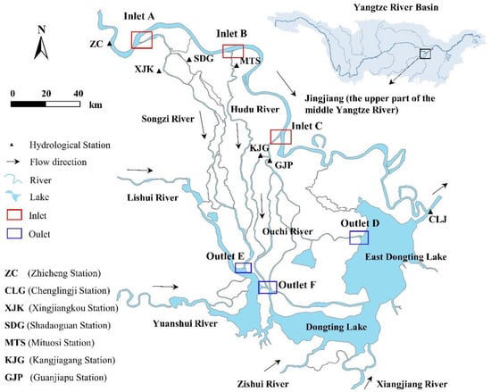
Figure 1.
Location and river network distribution of the Three Outlets Channel in the middle Yangtze River.
2.2. Remote Sensing Images Processing
A total of 14 remote sensing images (Landsat 4–5 TM and Landsat) for the Ouchi River from 1987–2016 were collected. Seven images of Hudu and Songzi River from 1984–2018 were selected. The images were sourced from Landsat 4–5 TM (1987), Landsat 8 (2014–2018), and Google Earth (1984, 1994, 2004, 2014). The spatial resolution of Landsat 8 and Landsat 4–5 TM is 30 m. The remote sensing images are all downloaded from the Geospatial Data Cloud (http://www.gscloud.cn/, accessed on 20 June 2020).
The Improved, Modified and Normalized Difference Water Index (MNDWI) was used to discern waterbodies in inlet and tail zones of the Three Outlets [27].
in which Green represents the green light band and MIR is the mid-infrared band. Google Earth images (0.6 m resolution) were used to measure geometric features of the siltation body and bar in inlet zones. The kmz data file generated was imported into ArcGIS and subjected to projection transformation to calculate the corresponding change of geometric feature. Remote sensing images were used for comparative analysis. The images were imported into ArcGIS to extract the water body information and measure the flat shape area in the inlet and tail zone of the TOC.
MNDWI = (Green − MIR)/(Green + MIR)
Since acquisition of remote sensing images is greatly affected by meteorological conditions, it is difficult to obtain remote sensing images of the same water level in different years. Remote sensing images in the dry season were selected to analyze morphological changes in inlet and tail zones of the TOC, in order to reduce the measurement error caused by the fluctuation in the water level. So, these images make the interannual evolution of the bars in the inlet and tail zone comparable.
2.3. Hydrological Data Analysis
Hydrological data of five hydrological stations (GJP, KJG, MTS, XJK, SDG) in Figure 1 were collected from the Changjiang Hydrological Bureau, including annual runoff and sediment in 1951–2003, average daily sediment concentration, flow discharge, and water levels in 2003–2016. The empirical relation between the daily relative water depth and the daily discharge was obtained using the Origin 9.0 software (OriginLab). Daily relative water depth is the difference between daily water levels and multi-year average water levels during the dry-flow period in 2003–2016. The average annual water level change during 2003–2016 was counted when the flow discharge was 0 m3/s as well as when the water level dropped in the inlet zone of the TOC. Considering the drop of water level in the inlet zone, the empirical formulae for the diversion discharge of five hydrological stations were fitted.
The daily water levels of the five hydrological stations in 2011–2016 were used to obtain the corresponding daily flow discharge. The difference between the calculated discharge and measured discharge was divided by the measured discharge, so the obtained value is squared as the relative error value. A relative error of less than 10% means that the formula meets the requirement, otherwise the formula needs further modification. Finally, the modified empirical formula was verified using the daily water level in 2017–2018.
The topography of the river channel adopts the measured data of the Changjiang Hydrology Bureau in 2003, 2006, 2009, and 2011. According to the grid terrain method, Surfer 11 was used to create a digital elevation model (DEM) of the local river reach in the TOC in 2003–2011. The grid was created using kriging interpolation to obtain Grd format files, and the boundary data were imported to form Bin files. The new Grd file was generated by whitening, and the DEM was generated after eliminating the influence of the bank-attached bar. Using the three volume calculation methods (Trapezoidal Rule, Simpson’s Rule and Simpson’s 3/8 Rule), the corresponding erosion and deposition volume were obtained. The cross-sectional topography method was used in 2006–2009 to calculate the amount of erosion and deposition in local reaches of the TOC.
3. Results and Analysis
3.1. Water and Sediment Flux Change
3.1.1. Ouchi River
Water and sediment in the east Ouchi River have been constantly decreasing in the last 70 years; especially in the 1970s–1980s (Figure 2a,b) average annual runoff and sediment load decreased by 60%. Similarly, the average annual runoff and sediment flux of the west Ouchi River decreased by nearly 90%. The two hydrological stations have a similar reduction proportion of runoff and sediment flux. After the 1980s, the decreasing trend of runoff and sediment flux in the Ouchi River slowed down, but a decrease in sediment was greater than in runoff. From period I (1971–1980) to period II (2011–2016), the average runoff of GJP decreased by 13.2 × 10⁹ m3, with a decrease rate of 57.7%, and the sediment transport decreased by 38.9 × 10⁶ t, with a decrease rate of 97.6%. During the same period, the multi-year average runoff of KJG decreased from 1.0 × 10⁹ m3 to 0.273 × 10⁹ m3, a decrease of 73.0%, and the multi-year average sediment load decreased from 1.91 × 10⁶ t to 34,700 t, a decrease of 98.2%. The ratio of sediment transport and runoff reduction in Ouchi River is unbalanced, and the ratio of sediment transport reduction is greater than that of runoff.
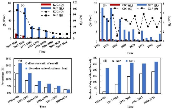
Figure 2.
Hydrological data of the KJG and GJP stations in the Ouchi River (Q: runoff, Qs: sediment load) (a) average runoff and sediment load in 1951–2016 (b) average runoff and sediment load in 2003–2016 (c) diversion ratio of runoff and sediment load (d) days of no water flow at the KJG and GJP hydrological station in 1951–2015.
Correspondingly, the diversion ratio of runoff and sediment load has been continually decreasing (Figure 2c). The diversion ratio of runoff merely decreased by 0.9% after the TGR impoundment (2003–2016), while the diversion ratio of sediment load was decreased by 2.7%. After the TGR impoundment, a reduction in runoff diversion was smaller than that after period I (1973–1980) and period II (1981–1998). The decreasing trend of the diversion ratio of runoff in the TOC has slowed down. The increasing rate of dry days at the GJP is much higher than that at the KJG. In 1981–2002, on average, the GJP and KJG had 167 and 252 dry days respectively, and this number slowly increased to 185 and 267 days, respectively in 2003–2016 (Figure 2d). After the TGR impoundment, the number of dry days at the KJG continuously increased, while the number of dry days at the GJP decreased, indicating that the TGR has played a positive role in reducing the incoming discharge of the Ouchi River.
3.1.2. Hudu River
Annual runoff and sediment load of the MTS at the Hudu River show a decreasing trend (Figure 3a,b). From the 1950s to the 1960s, runoff and sediment load at the MTS increased from 20.9 × 10⁹ m3 and 22.2 × 10⁶ t to 22.3 × 10⁹ m3 and 24.4 × 10⁶ t, respectively. However, from the 1990s to the 2000s, sediment load dropped sharply from 13.4 × 10⁶ t to 1.4 × 10⁶ t. After the impoundment of the TGR, a large amount of sediment load in the upstream was intercepted. After less sediment load was released, the sediment load in the Hudu River continued to decline. During the dry season, the runoff of the TGR played a positive role in maintaining the stability of the runoff of the Hudu River. Correspondingly, the diversion ratio of runoff and sediment load continually decreased (Figure 3c). After the TGR was the subject of works in 2003, the diversion ratio of sediment load decreased greatly, but runoff diversion barely changed. From the 1950s to the 1960s, the dry days of the Hudu River decreased by 66 days. However, from the 1960s to the 1980s, the dry days increased from 4 days to 143 days. This trend, however, changed after 2000. In 2001–2005, 2006–2010, and 2011–2016, the number of dry days was 160 days, 147 days, and 133 days, respectively. After the Gezhouba Dam was opened, the number of dry days at the SDG Hydrological Station increased sharply, and after the TGR was impounded, the number of dry days at the SDG Hydrological Station showed a decreasing trend.
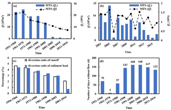
Figure 3.
Hydrological data of the MTS station in the Hudu River (Q: runoff, Qs: sediment load) (a) average runoff and sediment load in 1951–2016 (b) average runoff and sediment transport in 2003–2016 (c) diversion ratio of runoff and sediment load (d) days of no water flow at the MTS in 1951–2015.
3.1.3. Songzi River
Annual runoff and sediment load at the XJK and SDG showed a decreasing trend (Figure 4a,b). Before the 1980s, runoff and sediment load at the XJK changed with moderate variations. After the 1980s, annual sediment load significantly decreased from 38.4×10⁶ t to 2.6 × 10⁶ t, while runoff decreased from 31.9 × 10⁹ m3 to 21.8 × 10⁹ m3. During the same period, runoff and sediment load at the SDG decreased from 9.1 × 10⁹ m3 and 12.6 × 10⁶ t to 4.7 × 10⁹ m3 and 0.6 × 10⁶ t, respectively, and the reduction ratios reached 48.4% and 95.2%, respectively. At both stations, the decrease in runoff was slower than the decrease in sediment load. Runoff and sediment diversion of the Songzi River gradually decreased during the last 70 years (Figure 4c). After of the works on the TGR, the diversion ratio of runoff at the XJK decreased from 6.2% to 5.8%, while the diversion ratio of sediment load decreased from 6.6% to 2.4%. Meanwhile, the diversion ratio of runoff and sediment load at the SDG decreased from 1.5% and 1.6% to 1.3% and 0.6%, respectively. The decrease ratio for sediment load was more significant than for runoff. The dry days for the Songzi River increased from 0 days in the 1950s to 155 days in the 1980s. After the TGR was impounded, the number of dry days at the SDG showed an increase to a peak at first (209 days) and then a decreasing trend.
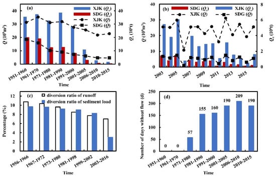
Figure 4.
Hydrological data of the XJK and SDG stations in the Songzi River (Q: runoff, Qs: sediment load) (a) average runoff and sediment transport in 1951–2016 (b) average runoff and sediment transport in 2003–2016 (c) diversion ratio of runoff and sediment load (d) days of no water flow at the XJK and SDG stations in 1951–2015.
3.2. Temporal Changes of Inlet and Outlet Channel Morphology
3.2.1. Ouchi River
Figure 5a–c shows the plane morphology of the inlet zone of the Ouchi River using Landsat images from 1987 to 2016. Due to the low water levels, in 2016 the riverbed was exposed. In 1987, the bars were dispersed independently rather than forming a whole sand bar. In 2001, the scattered bars gradually silted up and developed into integral sand bars. In 2016, the sand bars silted up and extended to the north, further reducing the inlet width of the Ouchi River. Figure 5d,e shows the channel morphology in 1984–2015 from Google Earth images. Bars in the inlet zone gradually coalesced from scattered siltation to a whole, and the river width in the inlet section narrowed slightly in 1984–2001. From 2005 to 2015, the sand bars in the inlet zone had completely merged into one, and the sedimentation intensified and developed toward the north. The river width continually narrowed, and the corresponding river channel continually developed and extended. The width of the river in the inlet section gradually narrowed, and the morphological changes of the silted bars affected the ability of runoff and sediment diversion in the Ouchi River. The bar area at the inlet zone of Ouchi River increased by 3698 m2 in 1984–1989 and then gradually decreased at a rate of 83 m2/year. Bar deposition in the inlet zone was dominated by siltation in the early stage, and decreases in area indicated that the bars had entered the scouring stage.
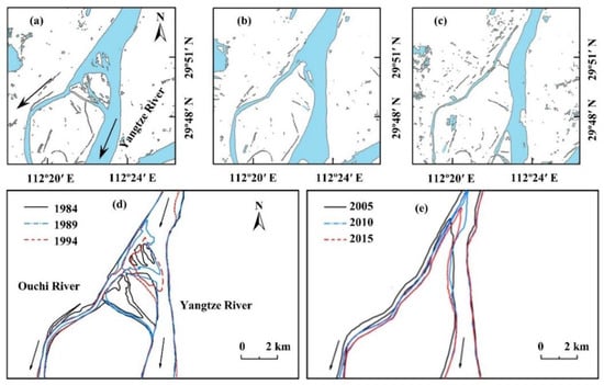
Figure 5.
Morphological change of the inlet zone in Ouchi River based on Landsat and Google Earth imagery in 1987–2016 (a) 17 September 1987 (b) 23 September 2001 (c) 5 December 2016 (d) 1984–1994 (e) 2005–2015.
Figure 6a–c shows that deposition in the tail section of the Ouchi River changed greatly in 1989–2001, and the end of the outlet continually deposited. The overall deposition area did not change much in 2001–2016. With the continuous development of the siltation area to the East Dongting Lake, the lake area was further reduced. The siltation area continually developed and grew; at the same time, the river channel in the tail zone continually extended, and the river width was correspondingly narrowed (Figure 6d,e). During the continuous extension of the river channel in the tail zone to the East Dongting Lake, the average width of the river channel in the tail zone shrank. From 1984 to 2015, the overall siltation of the river width of the eastern branch and tail zone of Ouchi River shrank and narrowed down at an average rate of 3.6 m/year, and the rate of shrinkage was the largest in 1984–1990, at 45.2 m on average.
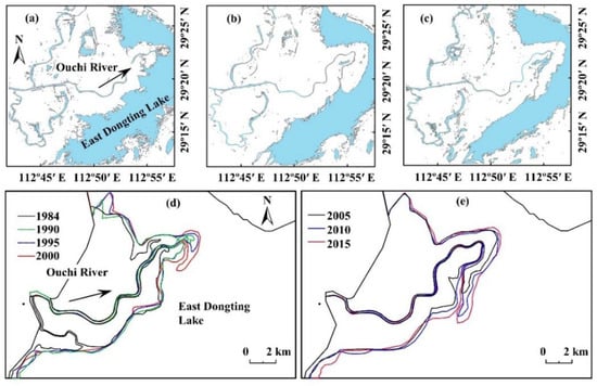
Figure 6.
Morphological change of the eastern branch in Ouchi River based on Landsat and Google Earth imagery in 1987–2016 (a) 26 January 1987 (b) 8 March 2001 (c) 30 December 2016 (d) 1984–2000 (e) 2005–2015.
3.2.2. Hudu River
In 1984, there were seven sand bars in the river course of the Hudu River (Figure 7). The area of Bar 1 increased from 0.08 km2 in 1984 to 0.19 km2 in 2001, and 0.26 km2 in 2016. In 1984, Bar 2 and 3 were separated. In 2001, the overall area of Bar 2 and Bar 3 increased from 2.17 km2 to 2.34 km2 and reached 2.58 km2 in 2016. Due to the sedimentation in the river channel, some sand bars have been connected to the right bank, and the water diversion capacity of the right branching channel was reduced after sediment blockage. The head of Bar 4 developed forward deposition, and its area increased from 0.79 km2 to 1.08 km2 in 2001–2016. From 1984 to 2016, changes in the plane morphology and area of Bar 5 and Bar 6 were relatively small.
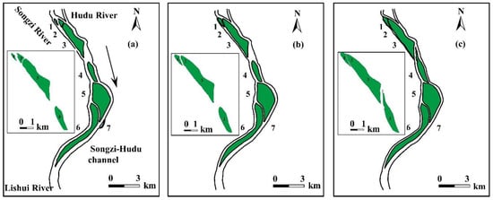
Figure 7.
Morphological change of the confluence channel of downstream Songzi–Hudu Channel based on Google Earth imagery in 1984–2016 (sand bars are numbered 1–7 from upstream to downstream) (a) 31 December 1984 (b) 31 December 2001 (c) 22 December 2016.
3.2.3. Songzi River
Figure 8 shows the morphology of the inlet zone of the Songzi River. Changes in the plane shape of the inlet zone were relatively small in 1987–2004, but from 2004–2018 scattered erosion sites were found in the inlet zone. The bar area at the mouth of the Songzi River decreased at a rate of 3% per year in 1987–2004. The second stable continental bar was 6 km away from the river mouth. Its planar area increased from 3.99 km2 in 1984 to 4.13 km2 in 1994, and finally to 4.60 km2 in 2014. The right side of the inlet zone in the Songzi River is situated in a mountainous area, and the left side is floodplain. Thus, the river is in the transition section between the mountainous area and the floodplain. Due to this special geographical location, the change of the plane shape of the inlet zone of the Songzi River was relatively small.
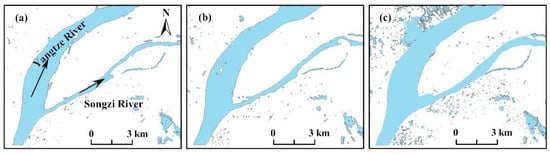
Figure 8.
Morphological change of the inlet zone in the Songzi River based on Landsat imagery in 1987–2018 (a) 6 December 1987 (b) 4 December 2004 (c) 9 January 2018.
3.3. Temporal Changes of Riverbed Deposition and Erosion
In the Ouchi River inlet zone, the channel volume was 76.44 × 10⁶ m3 and 74.49 × 10⁶ m3 in 2003 and 2011, respectively. Thus, erosion change in the inlet zone was about 1.95 × 10⁶ m3. The east branch was divided into four reaches to calculate the change of scour and deposition, which were derived as −0.54 × 10⁶ m3, 0.48 × 10⁶ m3, −0.63 × 10⁶ m3, and 0.53 × 10⁶ m3, respectively. Erosion and deposition alternately occurred at the east branch reaches, and the overall erosion was 0.16 × 10⁶ m3. The middle branch was mainly scoured, and the scoured amount was about 0.69 × 10⁶ m3. The cumulative amount of deposition in each river reach was 0.40 × 10⁶ m3 in the Ouchi River in 2006–2009. The diversion discharge ratio of the Ouchi River decreased and the continuous erosion capacity was insufficient, causing the scouring of the upper reaches of the East Branch and the sedimentation of the lower reaches in 2006–2009. The average deposition amount in the inlet zone of the Hudu River reached 5.72 × 10⁶ m3 using the three methods. The Hudu River was divided into upper, middle, and lower reaches to calculate the amount of erosion and deposition. The upper reach with 50.3 km long was scoured 1.53 × 10⁶ m3, while the middle and lower reaches were 39.2 km and 42.2 km long and were scoured 0.84 × 10⁶ m3 and 1.56 × 10⁶ m3, respectively. From 2006 to 2009, the Hudu River was totally scoured 3.93 × 10⁶ m3.
Erosion and deposition volumes of east and west branches of the Songzi River from 2003 to 2011 (Figure 9a,b) were 0.92 × 10⁶ m3, 0.74 × 10⁶ m3, and 1.08 × 10⁶ m3, respectively, with an average deposition of 0.91 × 10⁶ m3. The erosion and deposition sections were alternately distributed (Figure 9c). There were 10 erosion sections and 35 deposition sections in the west branch, and the erosion sections were mainly distributed in the upstream section (Figure 9d). Among the 10 sections in the middle branch reach, the second and tenth sections were scoured, while the rest were deposition sections (Figure 9e). From 2006 to 2009, the total deposition amount of the Songzi River was 6.83 × 10⁶ m3, and the deposition amount in the west branch was the largest (6.08 × 10⁶ m3), accounting for 89% of the total deposition amount. The eastern branch reached a total of 0.30 × 10⁶ m3 of erosion, and the middle branch reached 0.34 × 10⁶ m3 of deposition within three years.
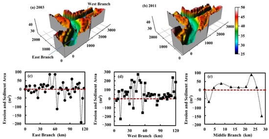
Figure 9.
Changes in erosion and deposition in local reaches of the Songzi River. (a,b) Digital elevation model of the partial reaches of the east–west branch of the Songzi River. (c–e) Erosion and deposition changes of typical sections of the main reaches of the Songzi River during the year (positive values on the coordinate for deposition, negative values for erosion, and the abscissa represents the length of each reach).
3.4. Prediction of Diversion Discharge in the Three Outlets Channel
3.4.1. Ouchi River
As previously mentioned in Section 3.3, the riverbed of the Jingjiang is much lower than the entrance section of the TOC. The formula form of weir flow discharge was adopted as the basis to develop the empirical formula for diversion discharge of the TOC. The relative water depth was the difference obtained after subtracting the average daily water level from 2003 to 2010. When the discharge is 0 m3/s, the daily average water level at the GJP is 30.02 m and 32.61 m at the KJG. Two rating curves are shown in Figure 10a,b. After the TGR was impounded, the flow release with low sediment concentration caused the average scour depth of the main stream of the Jingjiang, exceeding 2 m, and the water level dropped during the dry seasons. The change in water level drop when the flow was cut off in the inlet zone was the influencing factor of the relation between discharge and water level in the Ouchi River.
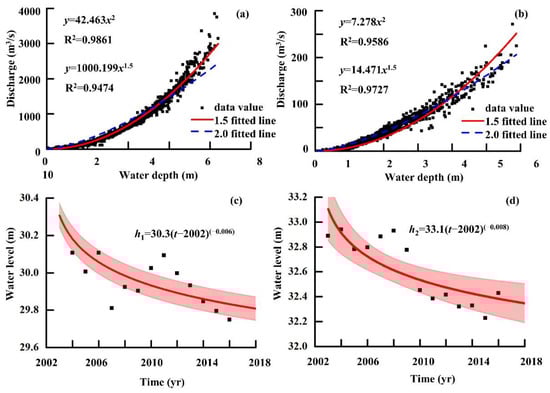
Figure 10.
Correlation between discharge and water depth in 2003–2010 (a) GJP (b) KJG (c) mean water level in 2003–2016 at GJP (d) mean water level in 2003–2016 at KJG.
Figure 10c,d was obtained from the statistics of the annual average water level when the discharge in the inlet zone was 0 m3/s in 2003–2016. During the dry seasons, a power nonlinear fitting function was used to obtain annual average water level changes at the GJP and KJG. When the mainstream of the Jingjiang was balanced by erosion and deposition, the water level in the inlet zone would no longer continue to drop. We assume that the erosion process of the lower Jingjiang section will stop after TGR operation for about 40 years [28]. Therefore, the water level will stop dropping in 2040, and the water level when the flow was cut off in 2040 shall prevail for the following years.
According to the cross-section data at GJP in 2006, the river width is 215 m when the water level is 30 m. When the water level at the KJG is 32 m, the channel width reaches 35 m. Considering changes in water level in the inlet zone when discharge is 0 m3/s, i.e., the corresponding channel width when the runoff is cut off, we have
where hi is the water level of each hydrological station when the discharge is 0 m3/s; Hi is the average daily water level of each hydrological station; t is the year after the impoundment of the TGR in 2003 (2003 ≤ t ≤ 2040, when t > 2040, t = 2040); Q1g, Q2k are the diversion discharge of the GJP and KJG considering water level and river width in the inlet zone during dry season, respectively; and Wi is the river width at the water surface when the discharge is 0 m3/s, 215 m and 35 m, respectively.
We then verified the accuracy of the formula using the discharge and water level at the GJP and KJG of the Ouchi River in 2011–2016. The daily average water level was input into Equations (2) and (3) to obtain the calculated discharge value as shown in Figure 11a,b. The closer the data point to the 45° line, the more accurate the calculated discharge. The measured discharge at the GJP is within the allowable error range of ±10% except for a few calculated discharges that are slightly larger at Q = 1500−2000 m3/s. From 2011 to 2016, the relative error between the calculated discharge and the measured discharge value was 2.4%, so the empirical formula at the GJP does not need to be revised.
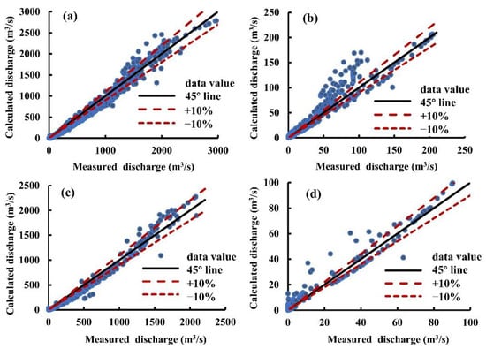
Figure 11.
Comparison of measured and calculated discharge in the Ouchi River (a) GJP in 2011–2016 (b) KJG in 2011–2016 (c) GJP in 2017–2018 (d) KJG in 2017–2018.
Before the empirical formula was corrected at the KJG, the relative error between calculated discharge and measured discharge was 19.7%. Therefore, a correction coefficient needs to be introduced. The relative errors obtained by the correction coefficients of 0.9, 0.8, and 0.7 are 14.6%, 10.6%, and 7.8%, respectively. The revised formulae for the Q1G at the GJP and Q1K at the KJG are:
where Q1G, Q2K are the diversion discharge of the GJP and KJG, respectively.
Based on the measured daily discharge and water level at the GJP and KJG in 2017–2018, the revised empirical formulae of the two stations in the Ouchi River were verified (Figure 11c,d). The calculated value at the GJP is roughly within ±10%, and the relative error is 4.5%. The relative error between the measured value and the calculated value after correction at the KJG is 13.7%. Therefore, the two empirical formulae (Equations (4) and (5)) basically conform to the actual situation.
3.4.2. Hudu River
Average annual water level when the discharge 0 m3/s calculated in 2003–2010 was 31.96 m. Average daily water depth is the difference of average daily water level and annual minimum water level. The corresponding relation between average daily discharge and relative water depth after excluding the discharge of 0 m3/s is shown in Figure 12a. The average water level at the MTS during 2003–2010 when the discharge was 0 m3/s showed a decreasing trend when the discharge stopped. Changes in average water level at the MTS during dry seasons were obtained by the nonlinear power function fitting (Figure 12b). Using daily average discharge and water level at the MTS in 2010–2016 as an independent variable, the discharge was calculated with the relative error of 12.1% (Figure 12c). Given that the correction coefficient is 0.8, the calculated discharge can be more in line with the 45° fitting line. The corrected formula is
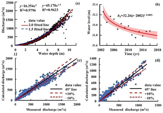
Figure 12.
(a) Correlation between discharge and water depth in 2003–2010, (b) annual average water level in 2003–2016; comparison of measured and calculated discharge (c) 2011–2016 (d) 2017–2018.
The modified empirical formula of discharge and water level was verified by the measured data at the MTS in 2017–2018 in Figure 12d. After correction, the relative error between the calculated and measured discharge is 11.5%, so the empirical formula meets the requirement.
3.4.3. Songzi River
There was no flow interruption at the XJK of the Songzi River in 2003–2010, and the average annual lowest water level was 35.0 m. Average water level at the SDG was 34.7 m when discharge was 0 m3/s. Average daily water depth of the two hydrological stations was the difference between daily average water level and average annual minimum water level. Figure 13a,b shows the corresponding relation between average daily water depth and daily discharge. The average water level at the SDG during 2003–2016 at an annual discharge rate of 0 m3/s was calculated, and the change in annual average water level at the SDG during the dry season was obtained using a nonlinear power function to fit (Figure 13d). During the same period, there was no flow interruption at the XJK, and the statistically annual average water level did not show a downward trend. The overall discharge at 35.0 m was small. Taking water level change corresponding to the discharge of 0–100 m3/s, the annual average water level change at the XJK in dry seasons was obtained using the nonlinear fitting. The empirical formula of discharge and water level at the XJK and SDG is,
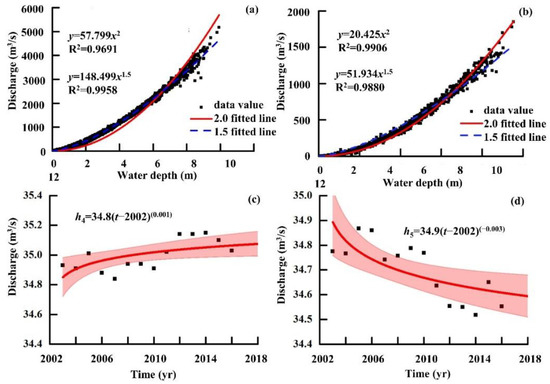
Figure 13.
Correlation between discharge and water depth in 2003–2010 (a) XJK (b) SDG; mean annual water level in 2003–2016 (c) XJK (d) SDG.
Using the relation of the average daily discharge and daily water level at the XJK and SDG in 2011–2016, the average daily water level was input into Equations (7) and (8) to obtain the corresponding calculated discharge. The comparison of measured discharge and calculated discharge is shown in Figure 14a,b. The revised empirical formula was verified by using the average daily discharge and water level data in 2017–2018. Figure 14c,d shows the comparison between measured and calculated discharge values of the XJK and SDG, respectively, i.e., basically close to the 45° fitting line. The relative errors between the calculated and measured discharge at the XJK and SDG were 4.5% and 7.3%, respectively, indicating that the empirical formula has good accuracy.
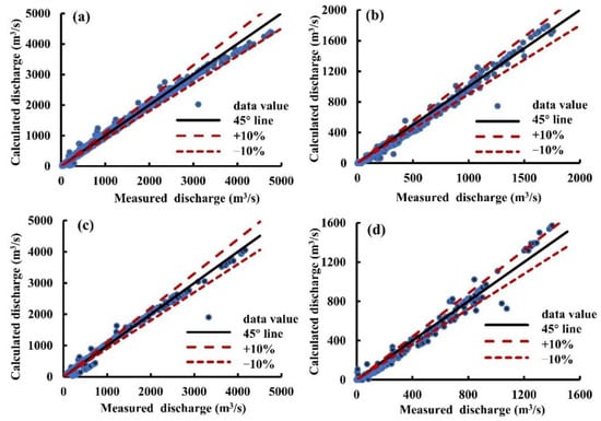
Figure 14.
Comparison of measured and calculated discharge in the Songzi River (a) XJK in 2011 –2016 (b) SDG in 2011–2016 (c) XJK in 2017–2018 (d) SDG in 2017–2018.
4. Discussion
Since the 1950s, the relation between the Jingjiang and Dongting Lake has undergone major adjustments, i.e., the decline of runoff and sediment load in the TOC. The diversions of runoff and sediment load in the TOC have obvious phased characteristics in the time nodes of water conservancy projects such as the Tiaoxiankou Gate Blocked Project (TGBP) in 1958, Cutoff Works of Lower Jingjiang (CWLJR) in 1967–1972, the closure of the Gezhouba Water Control Project (GWCP) in 1981 and the Three Gorges Project (TGP) in 2003. After the Three Gorges Reservoir (TGR) was impounded in 2003, it is still controversial whether the decrease in the diversion ratio of runoff and sediment load is accelerated or slowed down. For instance, Guo et al. [29] and Xie et al. [30] pointed out that the regulation and water storage of the TGR had a major influence on the diversion ratio of runoff and sediment load of the TOC. Instead, Qu et al. [31] and Hu et al. [32] thought that the construction of the TGP has a minor impact on the diversion and sediment separation of the TOC.
The diversion ratios of runoff and sediment load of the TOC in 1956–2016 are presented (Table 1). There are differences in the decreasing rate of runoff and sediment load ratio in the TOC in different time stages. In 1956–1966, the diversion ratios of runoff and sediment load of the TOC were 29.5% and 35.5%, respectively. In 1967–1972 and 1973–1980, the diversion ratio of runoff was reduced by 5.7% and 10.7%, respectively; compared with those before CWLJR, the diversion ratio of sediment load was reduced by 7.4% and 13.8%, respectively. After the CWLJR, the diversion ratio of runoff and sediment load was greatly reduced, and the reduction in the diversion ratio of runoff was slightly lower than that of the diversion ratio of sediment load. From 1981 to 1998, compared with the period from 1956 to 1966, the diversion ratio of runoff and sediment load decreased by 12.3% and 16.5%, respectively. The impact of the CWLJR on the diversion ratio of runoff and sediment load of the TOC is far greater than that in other time periods. To a certain extent, it can be shown that the main driving force for the sharp reduction of the TOC is the increased channel slope and mainstream bed incision induced by the CWLJR. In the period 2003–2016, compared to the period 1999–2002, the diversion ratio of runoff decreased by 2.4%, while the diversion ratio of sediment load decreased by 10.2%. After the impoundment of the TGR in 2003, the balance of runoff and sediment in the TOC was broken, which, on the one hand, accelerated the decline process of sediment transport and, on the other hand, delayed the attenuation of runoff.

Table 1.
The diversion ratios of runoff and sediment load at TOC in 1956–2016.
The decreasing rates of the diversion ratio of runoff and sediment load of Songzi River, Hudu River and Ouchi River are not consistent. From 1956 to 1966 to 1973 to 1980, the diversion ratio of runoff and sediment load of the Ouchi River decreased from 14.1% and 21.5% to 5.6% and 8.7%, which reduced by 8.5% and 12.8%, respectively. During the same period, the diversion ratio of runoff of Songzi River and Hudu River decreased by 1.1% and 1.0%, respectively, and the diversion ratio of sediment load decreased by 0.5% and 0.5%, respectively. The CWLJR is the main reason for the sharp decrease in the diversion ratio of runoff and sediment load of the Ouchi River, which directly changed the pattern of the diversion of runoff and sediment load in the TOC. The diversion ratio of runoff and sediment load of the Ouchi River before the CWLJR is predominant, and the diversion ratio of runoff and sediment load of the Songzi River after the CWLJR is gradually higher than that of the other two rivers, and the gap gradually widens in the later period. From 1999–2002 to 2003–2016, the decline rate of the diversion ratio of runoff of the TOC slowed down. The diversion ratio of runoff of the Ouchi River, Songzi River and Hudu River decreased by 0.9%, 0.7% and 0.7%, respectively, and the diversion ratio of sediment load decreased by 2.7%, 5.2% and 2.0%. Before the impoundment of the TGR, the diversion ratio of runoff and sediment load of the Songzi River showed a small downward trend. After the TGR was impounded, the diversion ratio of sediment load of the Songzi River dropped sharply to 63.4% due to the incoming sediment load reduction, but the diversion ratio of runoff decreased by only 9.1%. Consequently, the change of incoming runoff and sediment load is the fundamental reason for the evolution of the TOC because the construction of the hydropower projects in the upper and middle Yangtze River broke the original balance of runoff and sediment load.
Different understandings on the factors of the changes in the diversion of runoff and sediment load of the TOC exist in the long run, mainly including changes in the water level and elevation of the inlet area, the scouring of the Jingjiang bed, the deposition and shrinkage of the Dongting Lake, and the impact of the TGR. This study aims to reveal the recent evolution of the TOC and the influencing factors of the diversion of runoff and sediment load by the evolution of the plane morphology of the river channel. The right side of the Songzi River inlet is a mountainous area, and the left side is a floodplain. Songzi River is located in the transition section between the mountainous area and the plain. The special geographical location makes the change in the plane morphology of the Songzi River inlet relatively small. The other two rivers (Hudu River and Ouchi River) are located in the floodplain area, especially in the inlet area of Ouchi River, where serious sediment deposition has caused the inlet area to shrink rapidly, reducing the amount of runoff diversion. Under the premise of the overall downward trend of runoff diversion in the TOC, the reduction rate of the runoff diversion in the Songzi River was lower than that of the Ouchi River, and it became the main channel for the water diversion in the TOC. The morphological change in the inlet area is the secondary cause of the change in the distributary and sediment distribution of the TOC. The morphological changes in the inlet zone affected the diversion runoff and sediment load of the TOC to a certain extent.
After the impoundment of the TGR, the deposition of the channel in the TOC will be slowed down and slightly scoured, which will create favorable conditions for the comprehensive regulation of the TOC, the dredging and construction of sluices in the inlet zone of the Songzi River and the construction of high-grade waterway projects in the Dongting Lake area. Due to the limited topographic data of the TOC, this study however cannot exactly compare the erosion and deposition changes before and after the impoundment of the TGR. Since the comprehensive impact of the impoundment of the TGR on the TOC has not been fully revealed, the next step is to strengthen the topographic observation and hydrological data collection.
5. Conclusions
In this study, the modified empirical formulae for the diversion discharge of five hydrologic stations in the TOC were obtained, though a certain error is inevitable in the quantitative prediction of the impact of bed incision in the Jingjiang River on the diversion of discharge. The error can be further reduced when the empirical formulae can be improved using more topographic and hydrological data. More importantly, the empirical formulae can predict the influence of the water level drop on the diversion discharge in dry seasons. Meanwhile, considering the change of water level gradient along the TOC, it can also predict the impact of the reduction of diversion discharge on the rating curve along the river. Moreover, it could be a basis for flood control evaluation, irrigation diversion planning and the design of the TOC in the Dongting Lake area. To conclude, the main conclusions of this study are summarized as follows:
- (i)
- The main driving force for the sharp reduction of the diversion of runoff and sediment load of the TOC was the Cutoff Works of Lower Jingjiang River in 1967–1972. At this stage, the reduction process of runoff and sediment diversion in the Ouchi River was accelerated and the number of dry days increased. After the impoundment of the TGR, the diversion of sediment load of the TOC was greatly affected, but the decreasing trend of the diversion of runoff slowed down.
- (ii)
- Intense deposition occurred in the inlet zone of Ouchi River, where the river channel shrinks rapidly, leading to the decreasing diversion of runoff and sediment load. After the impoundment of the TGR, the recent deposition of the TOC has slowed down and has been slightly eroded.
- (iii)
- Five empirical formulae for the diversion discharge in the Three Outlets Channel were proposed and verified using the measured water levels and discharge. The relative error of the prediction of these five formulae meets the accuracy requirements and conforms to the actual condition. It is expected that these empirical formulae can be used to predict the change of the diversion discharge in the Three Outlets Channel for quantifying variation in the relation between Jingjiang and Dongting Lake.
Author Contributions
Conceptualization, Z.L. and B.C.; methodology, B.C.; software, B.C.; validation, Z.L. and B.C.; formal analysis, B.C.; investigation, Z.L. and B.C.; resources, Z.L.; data curation, Z.L. and B.C.; writing—original draft preparation, B.C. and Z.L.; writing—review and editing, Z.L. and D.W.; supervision, X.H.; project administration, Z.L. and X.H.; funding acquisition, Z.L. and X.H. All authors have read and agreed to the published version of the manuscript.
Funding
This research was funded by Open Research Fund of Key Laboratory of Hydro-Sediment Science and River Training [IWHR-JH-2020-A-01] and Major Project of Hunan Science & Technology Plan was funded by [2018SK1010].
Data Availability Statement
Data available in a publicly accessible repository that does not issue DOIs.
Acknowledgments
This study was supported by the Open Research Fund of Key Laboratory of Hydro-Sediment Science and River Training, the Ministry of Water Resources, Institute of Water Resources and Hydropower Research (Grant No. IWHR-JH-2020-A-01), and Major Project of Hunan Science & Technology Plan (2018SK1010).
Conflicts of Interest
The authors declare no conflict of interest.
References
- Ashworth, P.J.; Lewin, J. How do big rivers come to be different? Earth-Sci. Rev. 2012, 114, 84–107. [Google Scholar] [CrossRef]
- Latrubese, E.M. Patterns of anabranching channels: The ultimate end-member adjustment of mega rivers. Geomorphology 2008, 101, 130–145. [Google Scholar] [CrossRef]
- Nanson, G.C.; Knighton, A.D. Anabranching rivers their cause, character and classification. Earth Surf. Process. Landf. 1996, 21, 217–239. [Google Scholar] [CrossRef]
- Slingerland, R.; Smith, N.D. River avulsions and their deposits. Annu. Rev. Earth Planet. Sci. 2004, 32, 257–285. [Google Scholar] [CrossRef]
- Moodie, A.J.; Nittrouer, J.A.; Ma, H.; Carlson, B.N.; Chadwick, A.J.; Lamb, M.P.; Parker, G. Modeling Deltaic Lobe-Building Cycles and Channel Avulsions for the Yellow River Delta, China. J. Geophys. Res. Earth Surf. 2019, 124, 2438–2462. [Google Scholar] [CrossRef]
- Sinha, R.; Sripriyanka, K.; Jain, V.; Mukul, M. Avulsion threshold and planform dynamics of the Kosi River in north Bihar (India) and Nepal: A GIS framework. Geomorphology 2014, 216, 157–170. [Google Scholar] [CrossRef]
- Valenza, J.M.; Edmonds, D.A.; Hwang, T.; Roy, S. Downstream changes in river avulsion style are related to channel morphology. Nat. Commun. 2020, 11, 2116. [Google Scholar] [CrossRef]
- Zheng, S.; Han, S.; Tan, G.; Xia, J.; Wu, B.; Wang, K.; Edmonds, D.A. Morphological adjustment of the Qingshuigou channel on the Yellow River Delta and factors controlling its avulsion. Catena 2018, 166, 44–55. [Google Scholar] [CrossRef]
- Wang, X.; Li, X.; Wu, Y. Maintaining the connected river-lake relationship in the middle Yangtze River reaches after completion of the Three Gorges Project. Int. J. Sediment Res. 2017, 32, 487–494. [Google Scholar] [CrossRef]
- Wan, R.R.; Yang, G.S.; Wang, X.L.; Qin, N.; Dai, X. Progress of research on the relationship between the Yangtze River and its connected lakes in the middle reaches. J. Lake Sci. 2014, 26, 1–8. (In Chinese) [Google Scholar]
- Hu, C.H.; Fang, C.M.; Cao, W.H. Shrinking of Dongting Lake and its weakening connection with the Yangtze River: Analysis of the impact on flooding. Int. J. Sediment Res. 2015, 30, 256–262. [Google Scholar] [CrossRef]
- Ou, C.M.; Li, J.B.; Zhou, Y.Q.; Cheng, W.; Yang, Y.; Zhao, Z. Evolution characters of water exchange abilities between Dong ting Lake and Yangtze River. J. Geogr. Ciences 2014, 24, 731–745. [Google Scholar] [CrossRef]
- Zhang, R.; Zhang, S.H.; Xu, W.; Wang, B.D.; Wang, H. Flow regime of the three outlets on the south bank of Jingjiang River, China: An impact assessment of the Three Gorges Reservoir for 2003–2010. Stoch. Environ. Res. Risk Assess. 2015, 29, 2047–2060. [Google Scholar] [CrossRef]
- Yuan, Y.J.; Zhang, C.; Zeng, G.M.; Liang, J.; Guo, S.; Huang, L.; Wu, H. Quantitative assessment of the contribution of climate variability and human activity to streamflow alteration in Dongting Lake, China. Hydrol. Process. 2016, 30, 1929–1939. [Google Scholar] [CrossRef]
- Dai, X.; Yang, G.S.; Wan, R.R.; Li, Y. The effect of the changjiang river on water regimes of its tributary lake east dongting lake. J. Geogr. Sci. 2018, 28, 1072–1084. [Google Scholar] [CrossRef]
- Lu, J.Y. Study on laws of runoff and sediment diverted from Three Outlets on the Jingjiang reach of the Yangtze River. J. Sediment Res. 1996, 4, 55–62. (In Chinese) [Google Scholar]
- Fang, C.M.; Cao, W.H.; Lu, W.; Zhong, Z.Q.; Zhao, J.L. The analysis of Ouchi river’s heavy deposit and rapid reduction of discharge and sediment caused by Jingjiang truncation. J. Sediment Res. 2002, 2, 40–45. (In Chinese) [Google Scholar]
- Li, J.B.; Wang, K.L.; Qin, J.X. The evolution of annual runoff and sediment in the Dongting Lake and their driving forces. Acta Geogr. Sin. 2005, 60, 503–510. (In Chinese) [Google Scholar]
- Xu, Q.X.; Hu, G.Y.; Yuan, J. Research on the flow and sediment diversion in the three outlets along Jingjiang River in recent 50 years. J. Sediment Res. 2009, 50, 1–8. (In Chinese) [Google Scholar]
- Xia, J.Q.; Deng, S.S.; Lu, J.Y.; Xu, Q.; Zong, Q.; Tan, G. Dynamic channel adjustments in the Jingjiang Reach of the Middle Yangtze River. Sci. Rep. 2016, 6, 22802. [Google Scholar] [CrossRef]
- Lu, J.Y.; Yao, S.M. Response mechanism of the river and lakes in the middle and lower reaches of the Yangtze River under the combined effect of reservoir groups. J. Hydraul. Eng. 2018, 49, 36–46. (In Chinese) [Google Scholar]
- Li, Y.T.; Guo, X.H.; Tang, J.W.; Sun, Z.H. Changes on runoff diversion from Jingjiang reach of the Yangtze River to Dongting lake after the operation of Three Gorges reservoir. J. Basic Sci. Eng. 2009, 17, 21–31. (In Chinese) [Google Scholar]
- Xu, K.H.; Milliman, J.D. Seasonal variations of sediment discharge from the Yangtze River before and after impoundment of the Three Gorges Dam. Geomorphology 2009, 104, 276–283. [Google Scholar] [CrossRef]
- Fang, C.M.; Hu, C.H.; Chen, X.J. Impacts of Three Georges Reservoir’s operation on outflow of the three outlets of Jingjiang River and Dongting Lake. J. Hydraul. Eng. 2014, 45, 36–41. (In Chinese) [Google Scholar]
- Li, Y.T.; Deng, J.Y.; Sun, Z.H. A study on the flood storage capacity in Dongting Lake. Int. J. Sediment Res. 2003, 2, 138–147. [Google Scholar]
- Yin, H.F.; Liu, G.R.; Pi, J.G.; Chen, G.; Li, C. On the river-lake relationship of the middle Yangtze reaches. Geomorphology 2006, 85, 197–207. [Google Scholar] [CrossRef]
- Xu, H.Q. A Study on Information Extraction of Water Body with the Modified Normalized Difference Water Index (MNDWI). Natl. Remote Sens. Bull. 2005, 5, 589–595. (In Chinese) [Google Scholar]
- Zhu, L.L.; Chen, J.C.; Yuan, J.; Dong, B.J. Study on variation trends of flow diversion from Jingjiang River to Dongting Lake. J. Hydroelectr. Eng. 2015, 34, 103–111. (In Chinese) [Google Scholar]
- Guo, X.H.; Yao, S.M.; Yam, L.M. Variation of split-flow and sediment diversion at the three outlets along Jingjiang River and Water and sediment transport at the Outlet of Dongting Lake. J. Yangtze River Sci. Res. Inst. 2011, 28, 80–86. (In Chinese) [Google Scholar]
- Xie, Y.H.; Li, F.; Chen, X.S.; Hou, Z.Y. Runoff and Sediment Discharge into Dongting Lake from Three Channels, Jingjiang River. Res. Agric. Mod. 2012, 33, 203–206. (In Chinese) [Google Scholar]
- Qu, G.; Liu, X.Y.; Guo, X.H.; Tang, F. Analysis on runoff and sediment diversion of Ouchikou before and after impounding of the Three Gorges reservoir. J. Hydraul. Eng. 2013, 44, 1099–1106. (In Chinese) [Google Scholar]
- Hu, G.W.; Mao, D.H.; Li, Z.Z.; Zeng, Y.; Feng, C. Characteristics and driving factors of runoff and sediment changes fluxes into the Dongting Lake from three outlets in Jingjiang River during past 60 Years. J. Nat. Resour. 2014, 29, 129–142. (In Chinese) [Google Scholar]


Publisher’s Note: MDPI stays neutral with regard to jurisdictional claims in published maps and institutional affiliations. |
© 2022 by the authors. Licensee MDPI, Basel, Switzerland. This article is an open access article distributed under the terms and conditions of the Creative Commons Attribution (CC BY) license (https://creativecommons.org/licenses/by/4.0/).