Towards Sustainable River Management of the Dutch Rhine River

Abstract
:1. Introduction
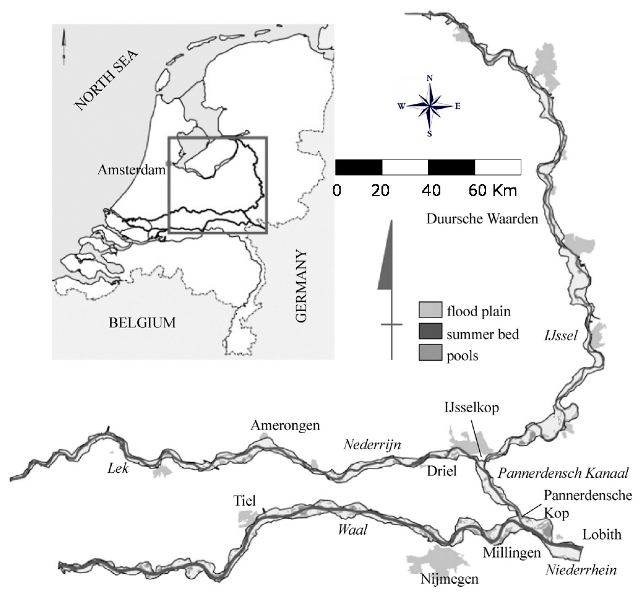
2. Historical Development and Current Trends
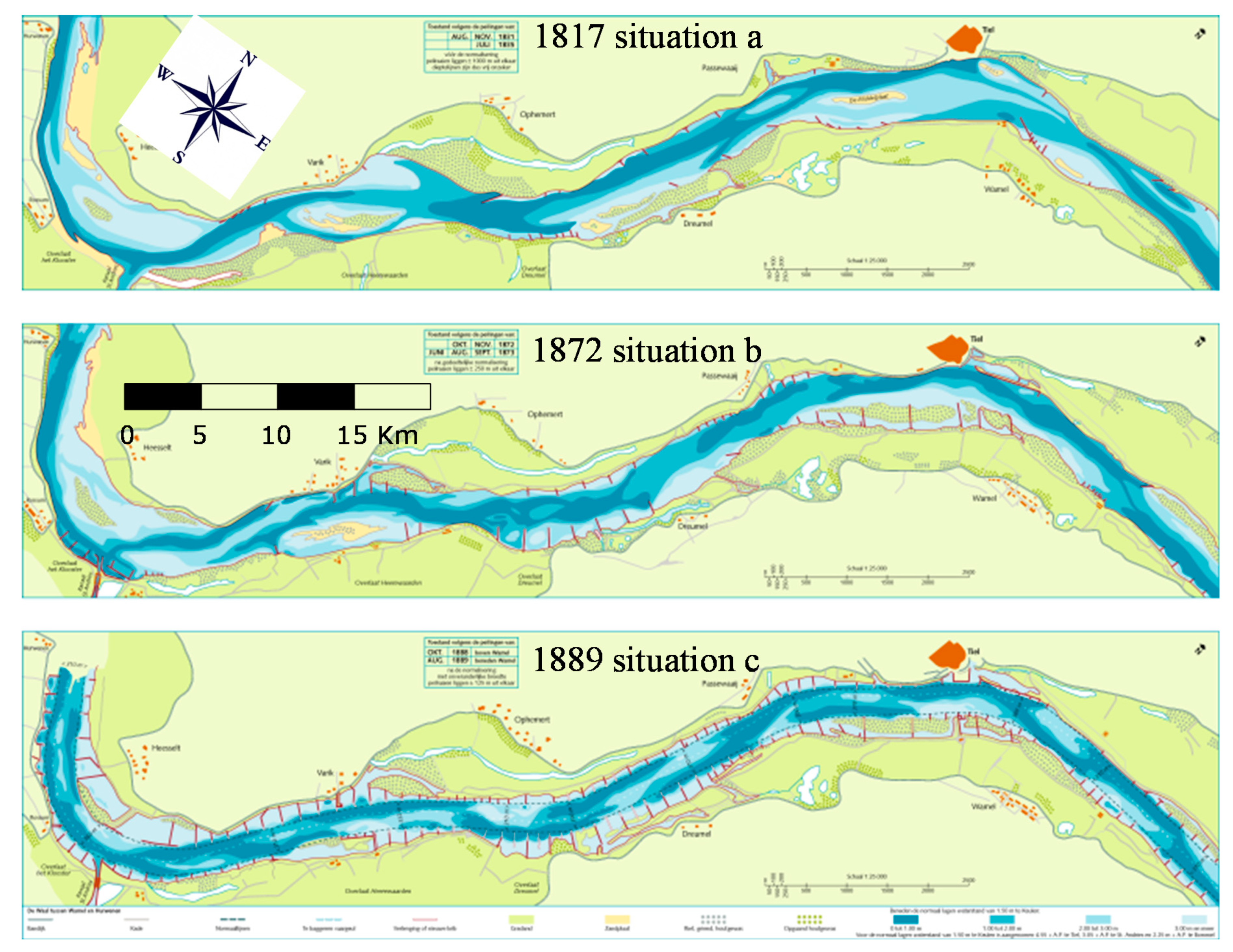
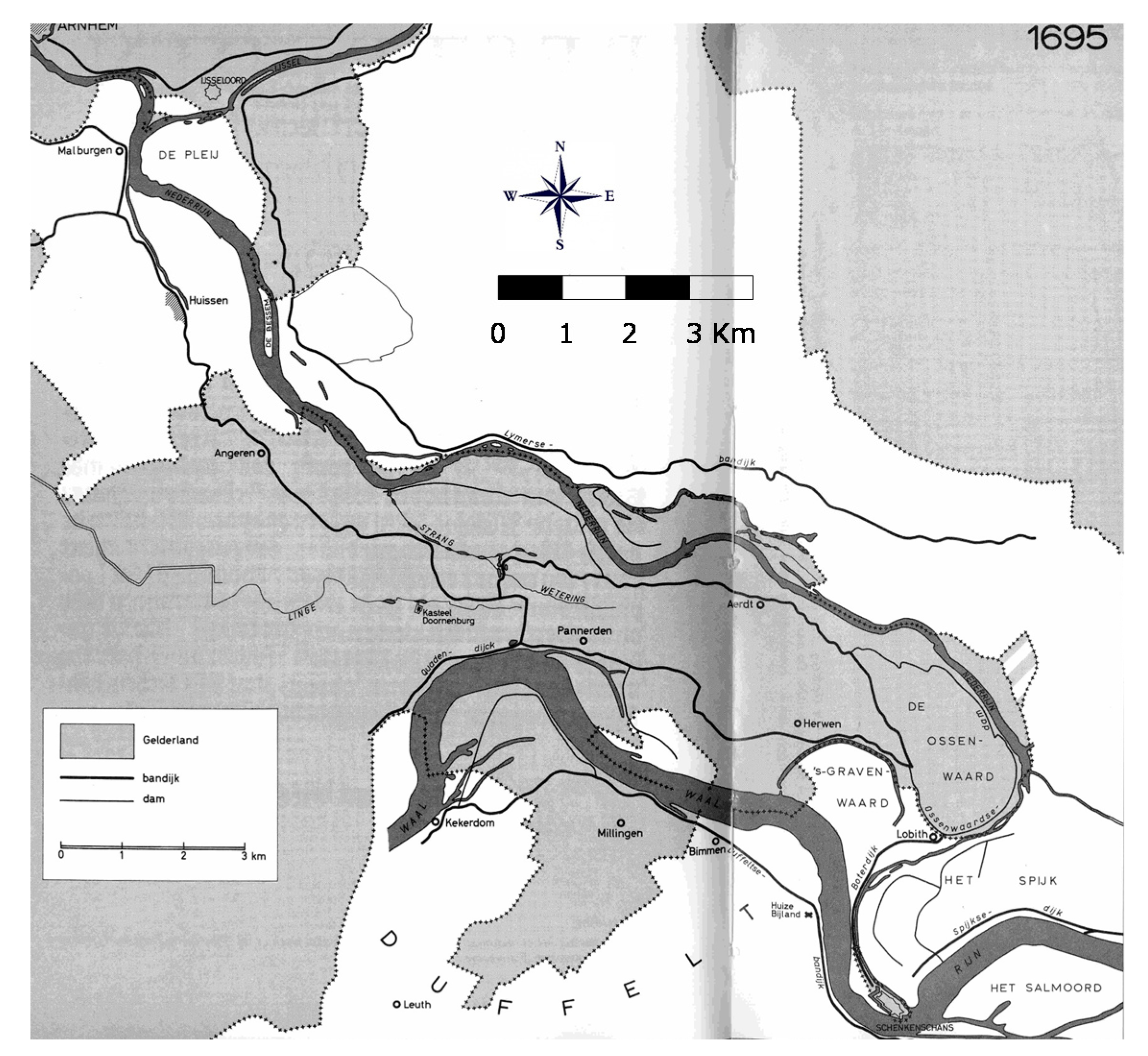
2.1. Historical Development
2.2. Current Trends
3. Recent Sectoral River Improvement Programs
3.1. Safety Against Flooding
- The water storage capacity of urban and agricultural areas must be increased in order to prevent the rapid drainage of rainwater [2].
- Further reduction in the space for the river must be prevented. Legislation called “Room for the River” is in force in the Netherlands. This will prevent construction activities in the floodplain that are not of crucial importance to society (such as housing in the floodplain).
- The space available for the riverbed of the Rhine and its tributaries must be increased. This can be achieved by constructing retention polders and secondary channels, as well as removing obstacles in the river bed for the discharging water. The Room for the River (RfR) program [8] was implemented for this purpose between 2004 and 2018.
- Nature values and biodiversity of banks and floodplains must be increased as much as possible when measures are implemented. This has been confirmed in the European WFD [9].
3.1.1. Prologue: Rhine in the Long Term
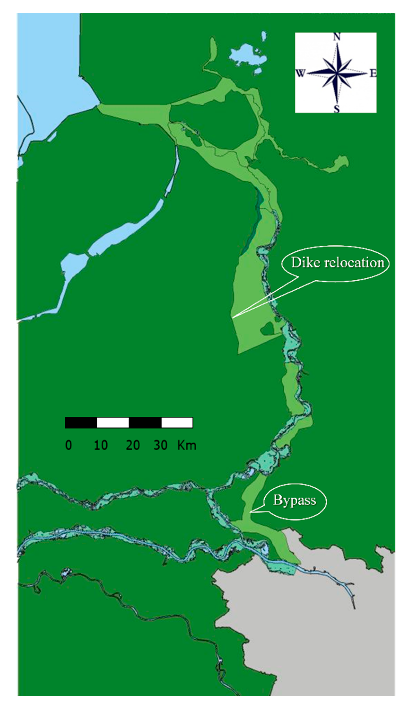
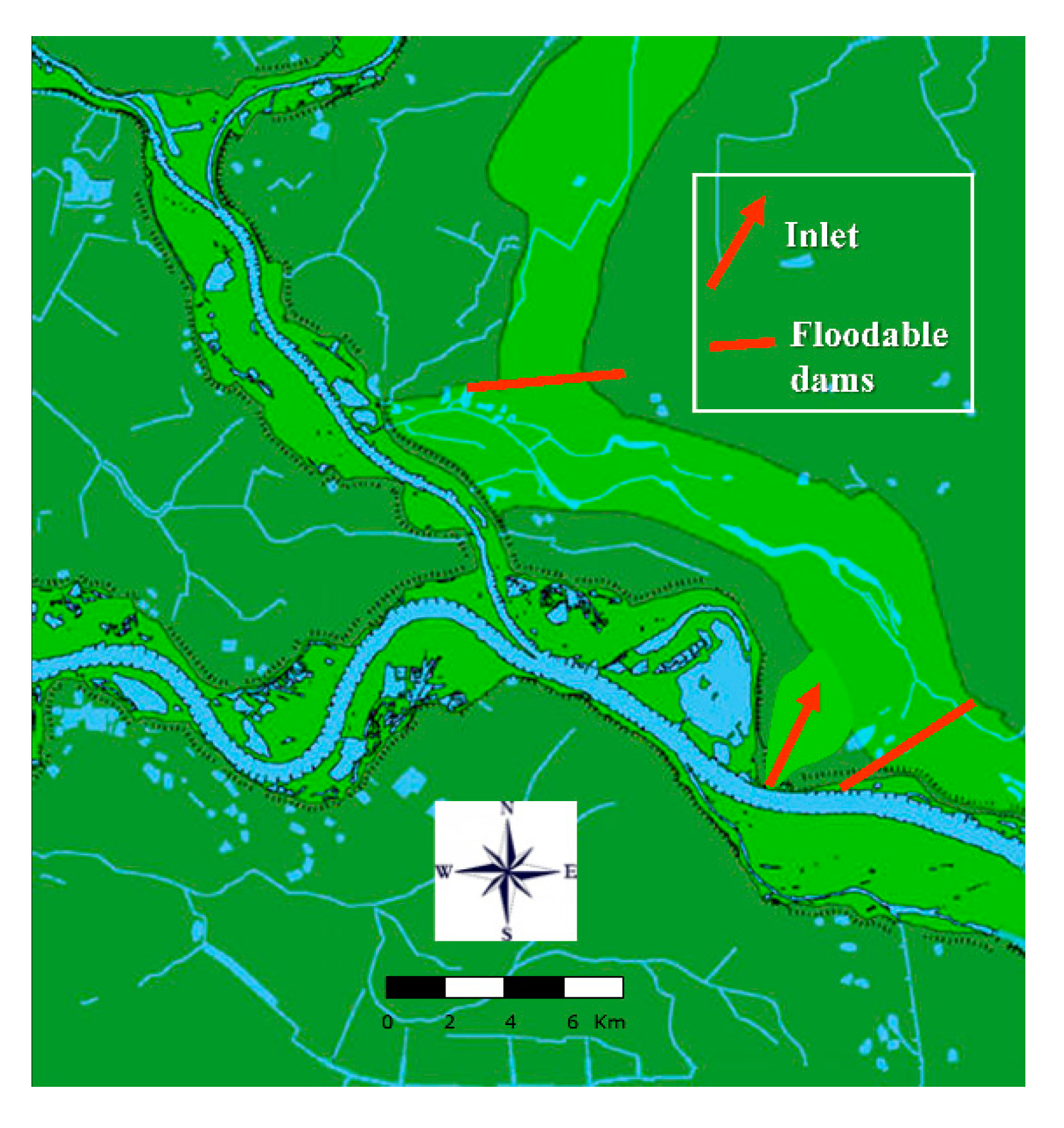
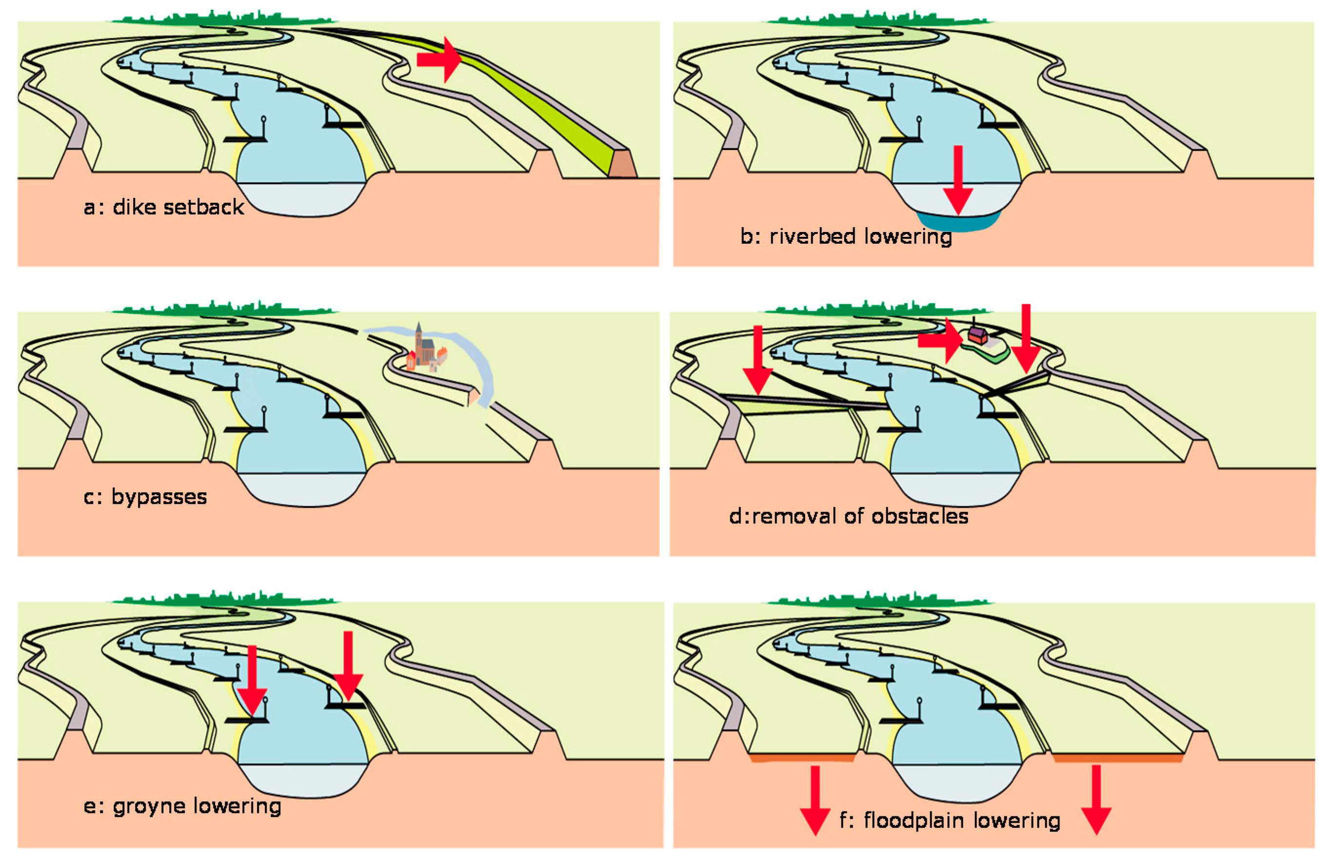
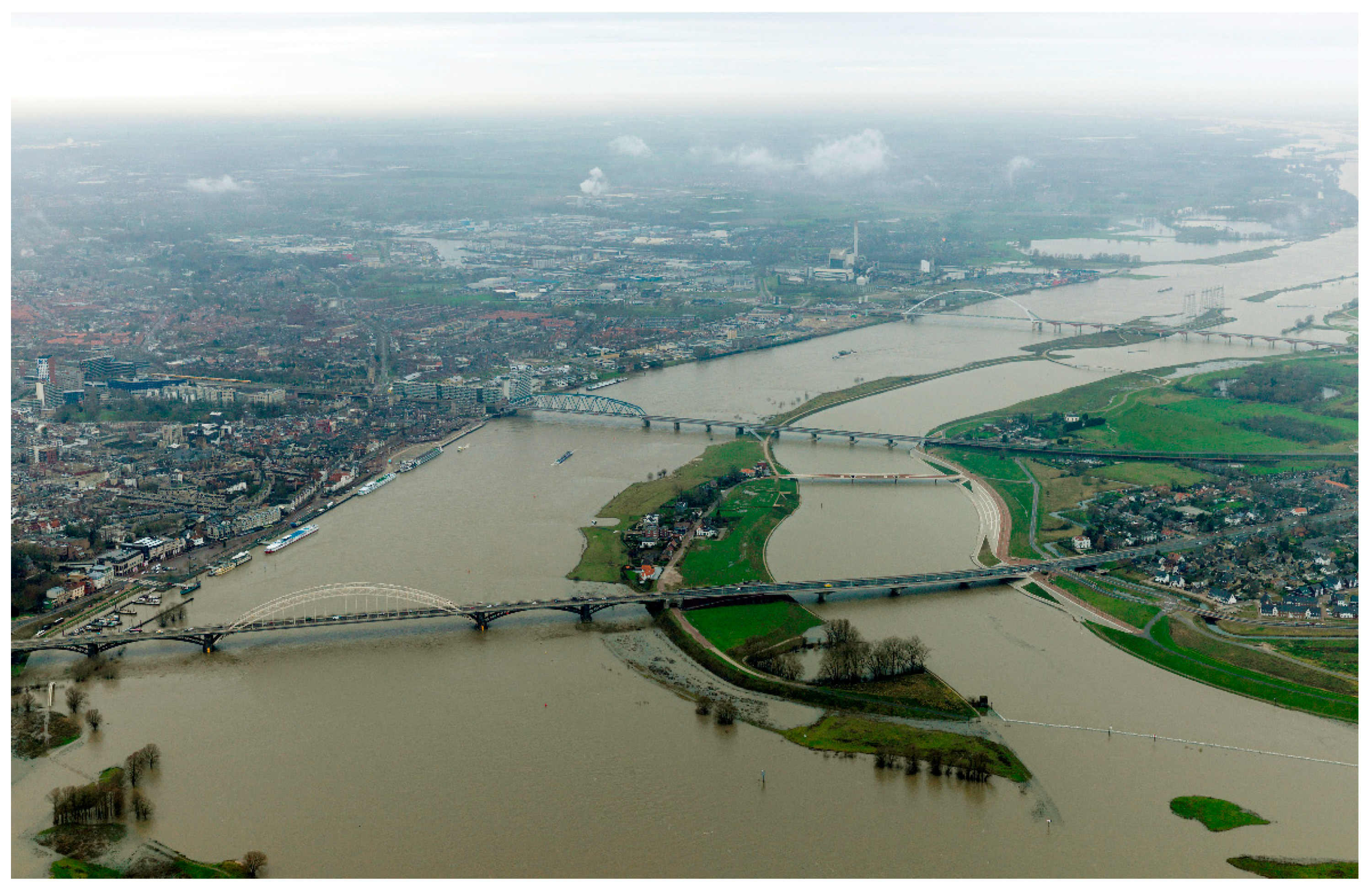
3.1.2. Room for the River
3.1.3. Delta Program for Rivers (DPR)
3.2. Inland Waterways
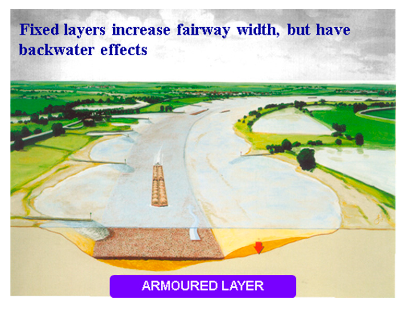
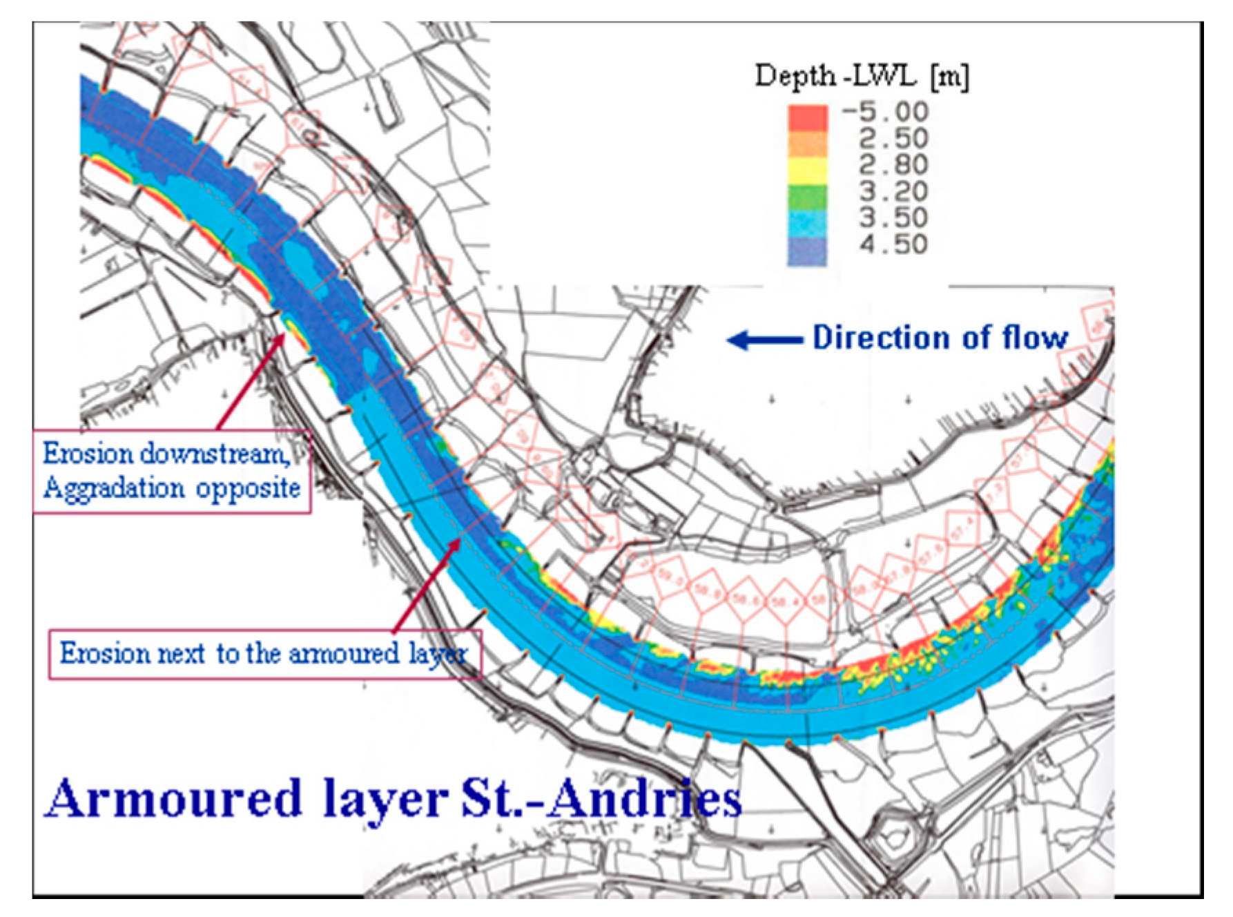
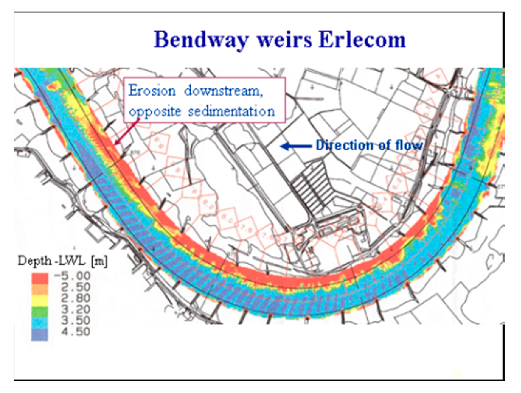
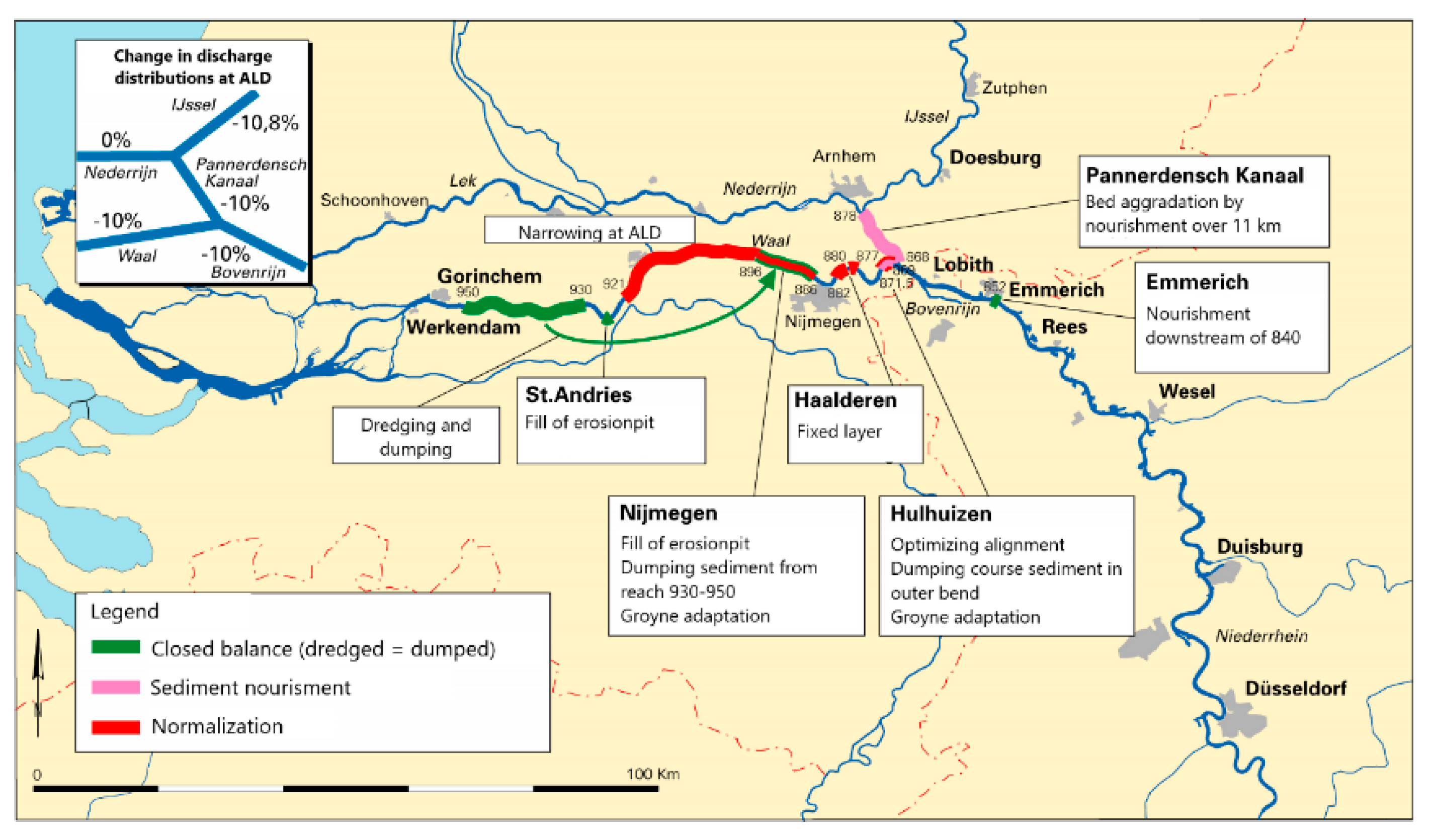
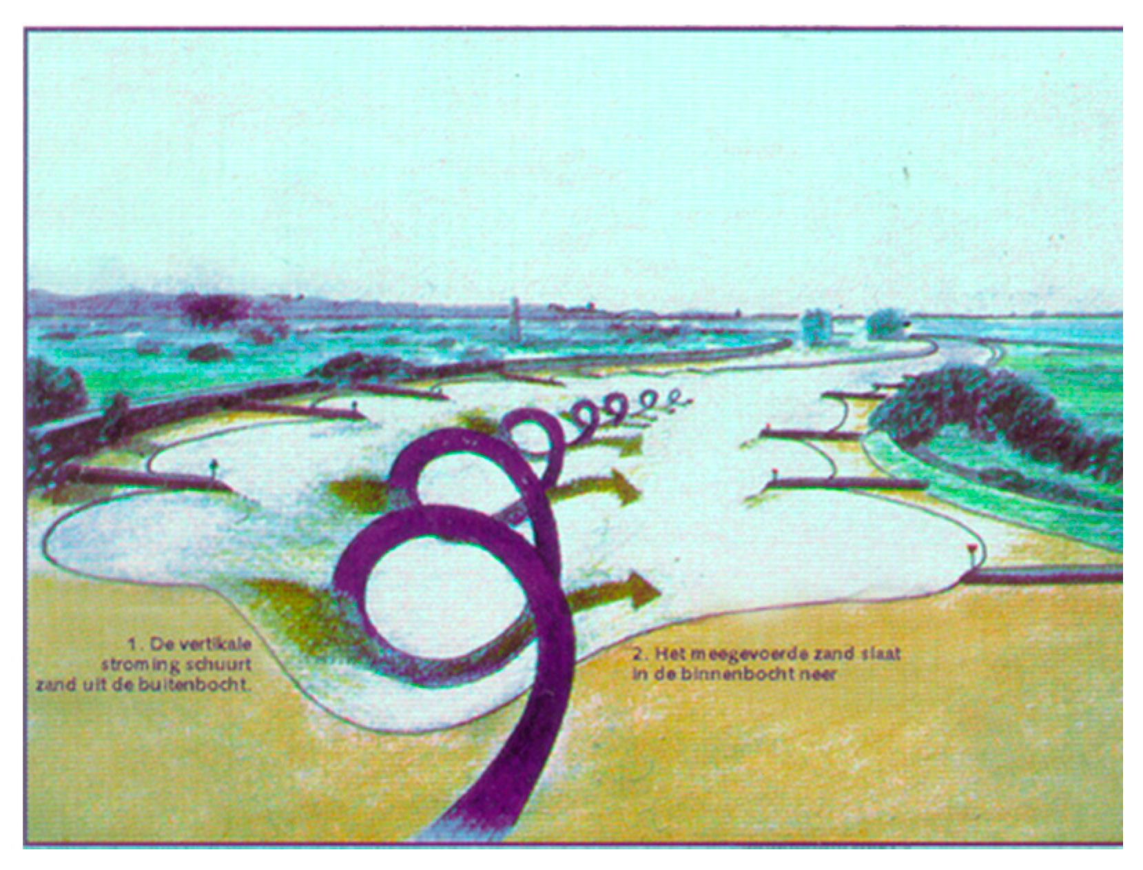
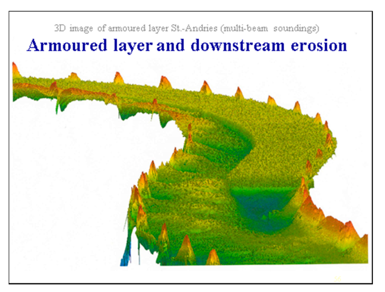
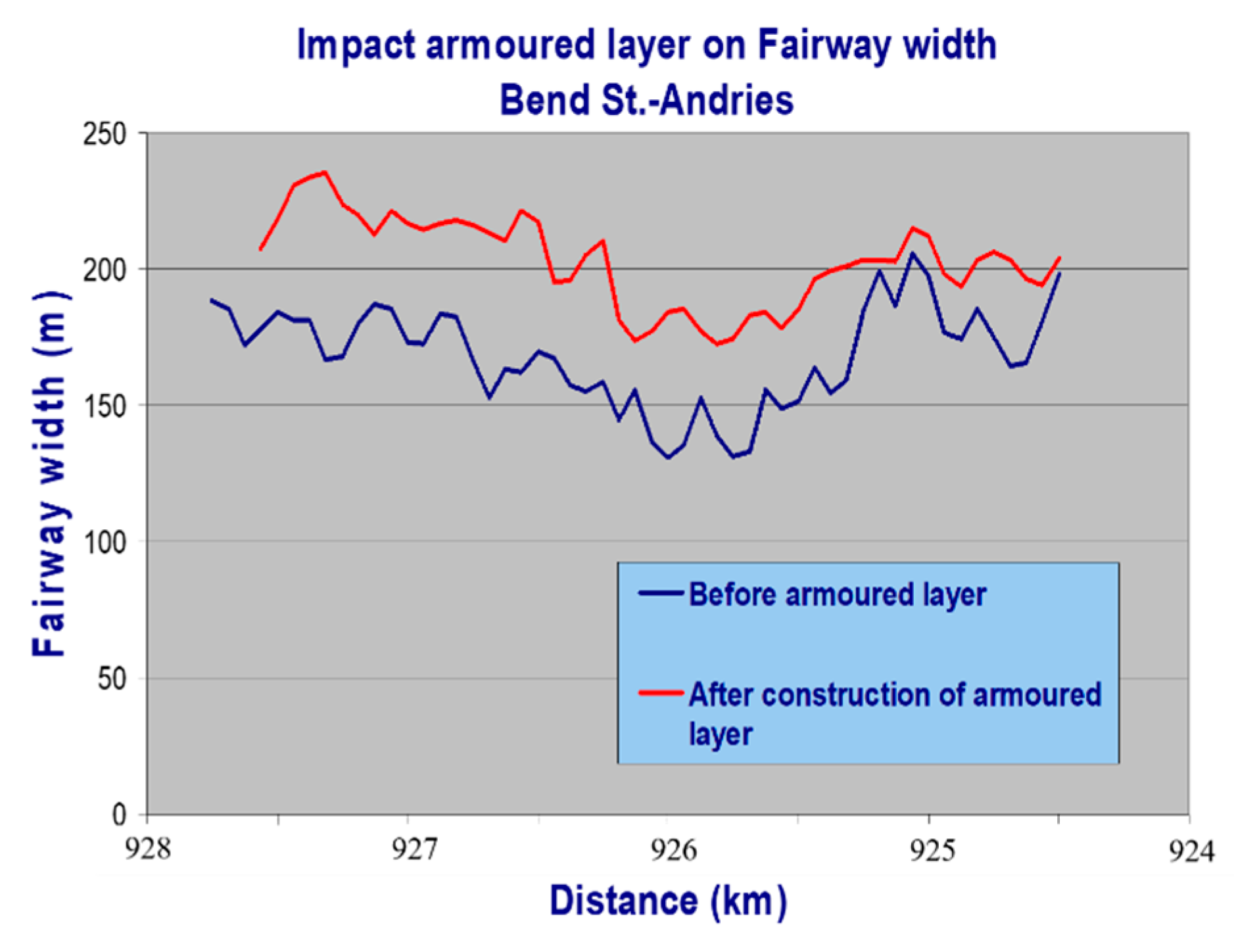
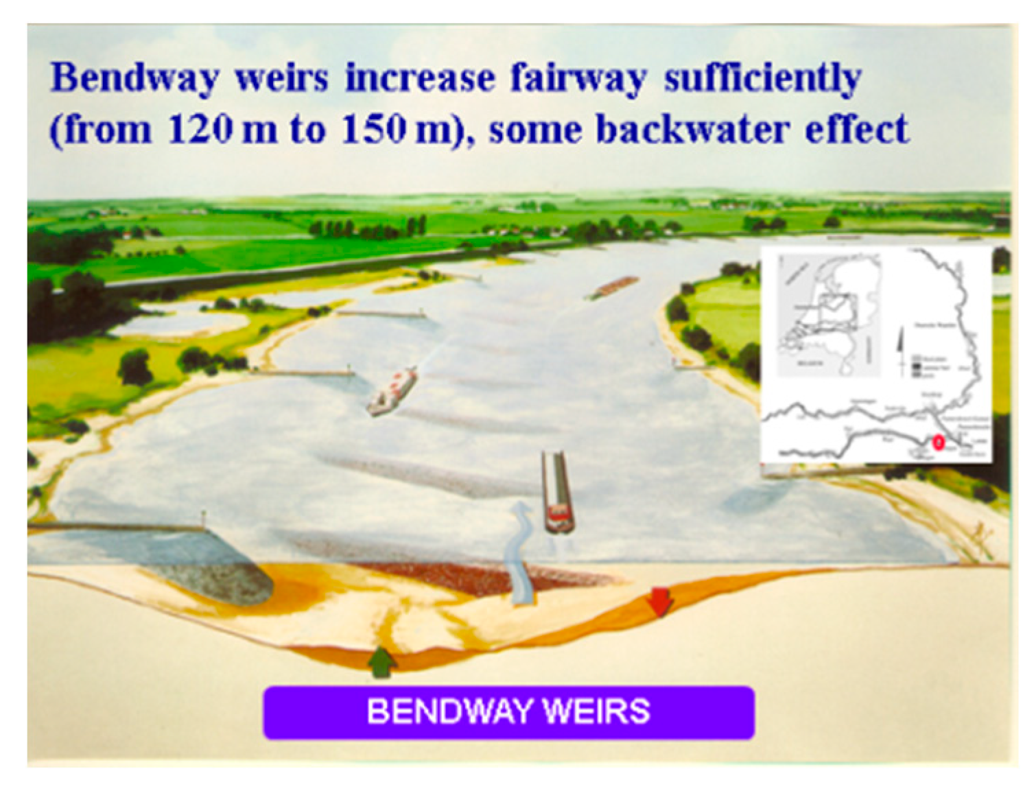
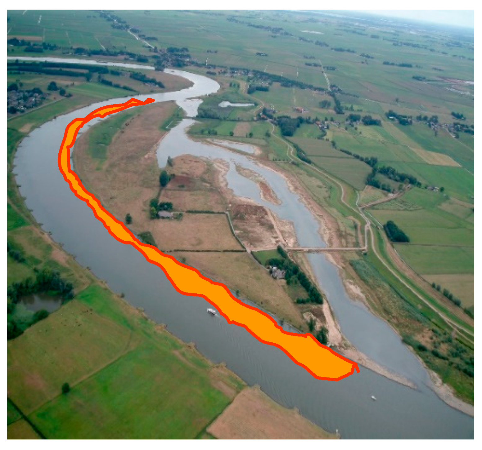
3.2.1. Bend Measures
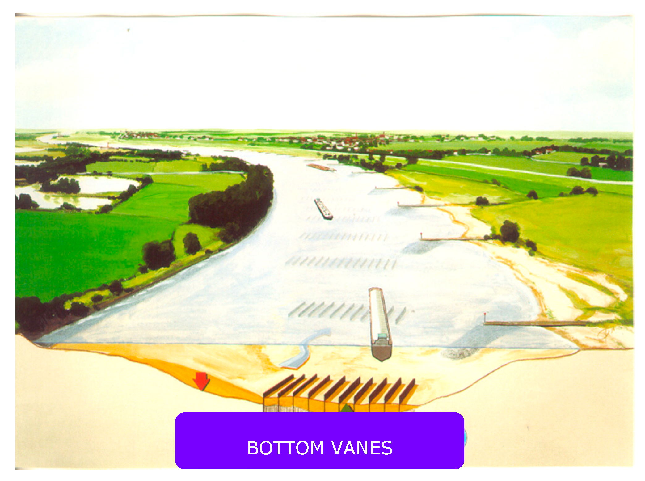
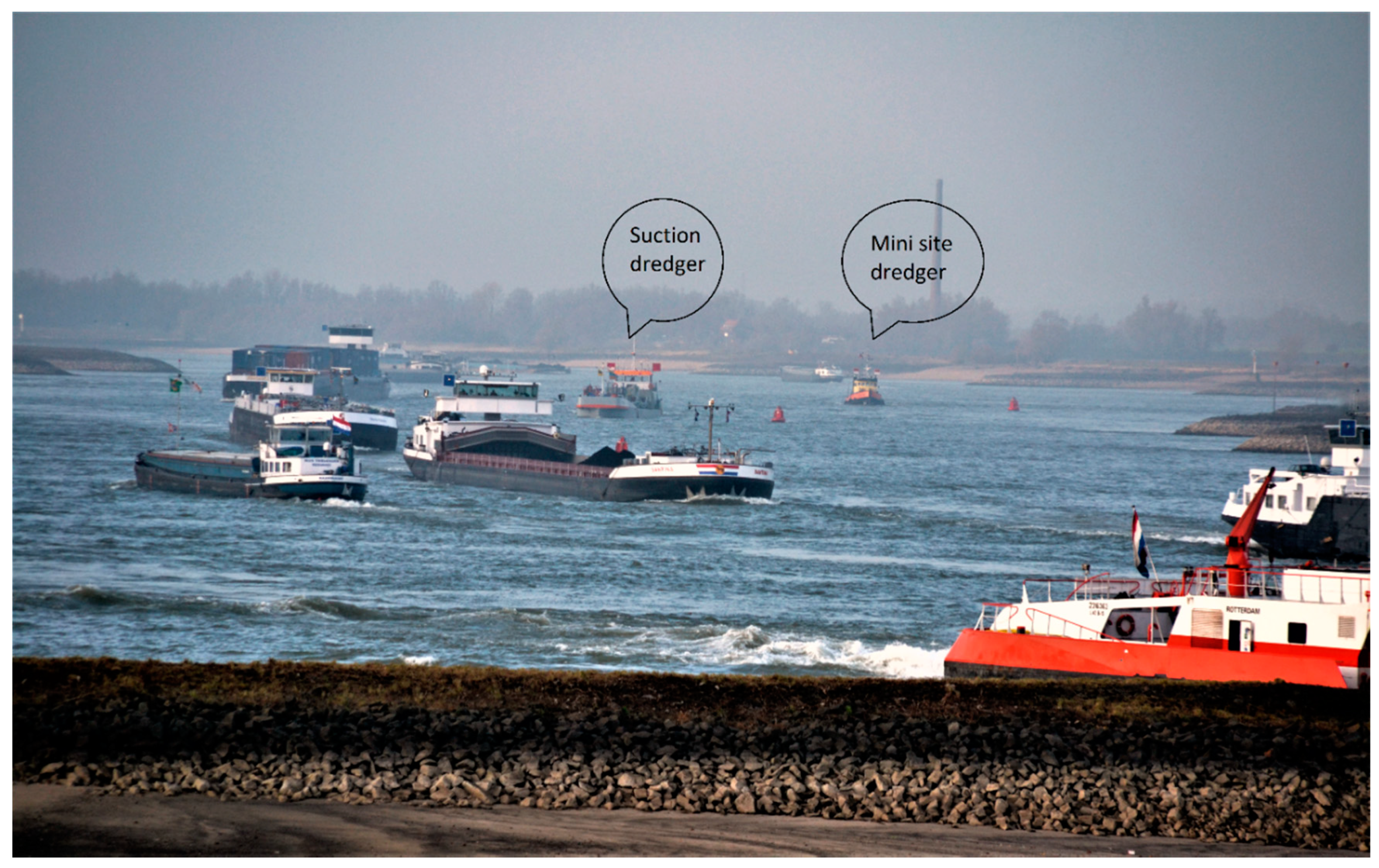
3.2.2. Dredging as a Permanent Measure
3.2.3. Sustainable Fairway Rhine Delta
3.3. Nature
4. Implications for River Management
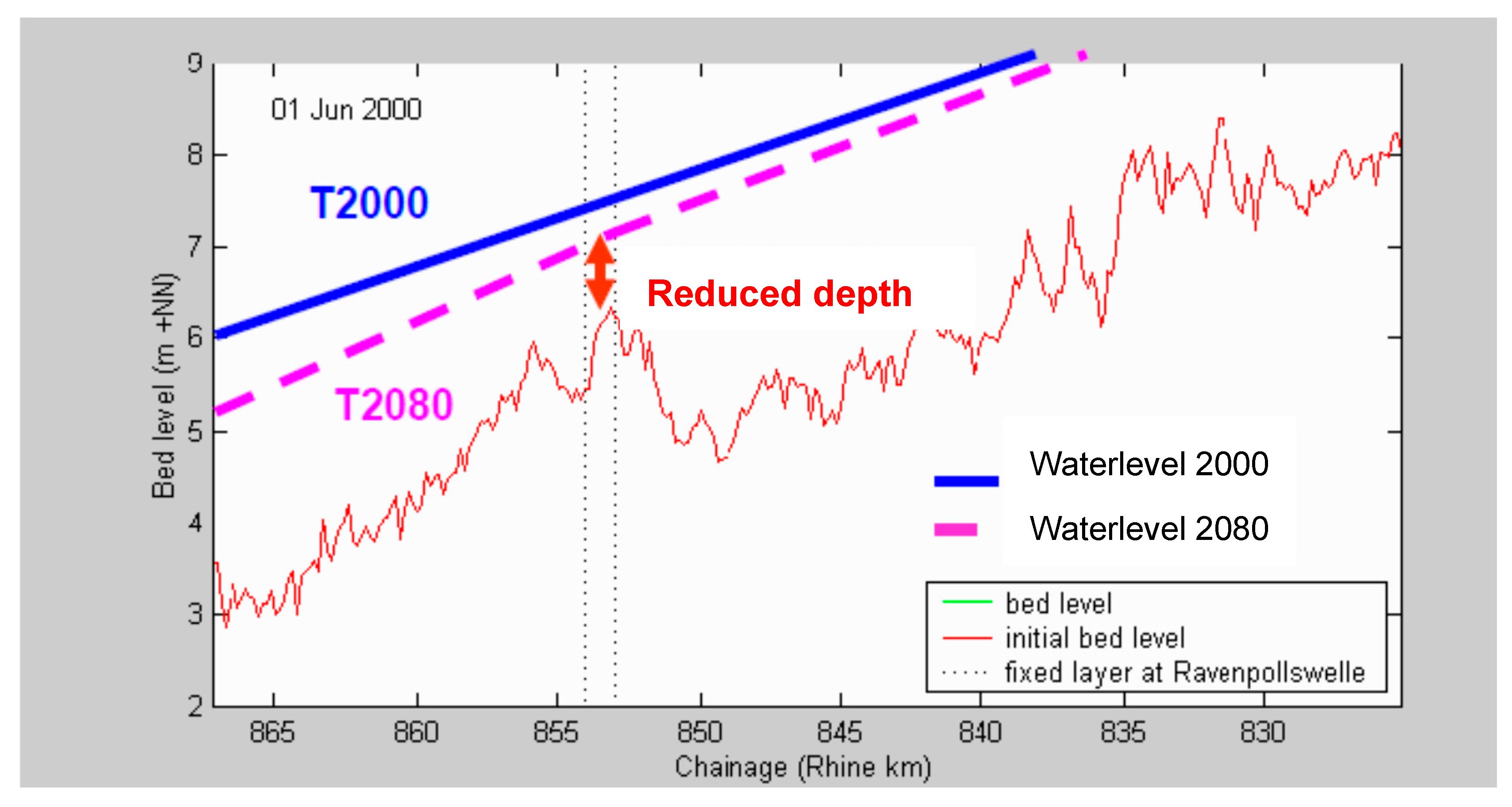
4.1. Limitation of the Morphological Effects
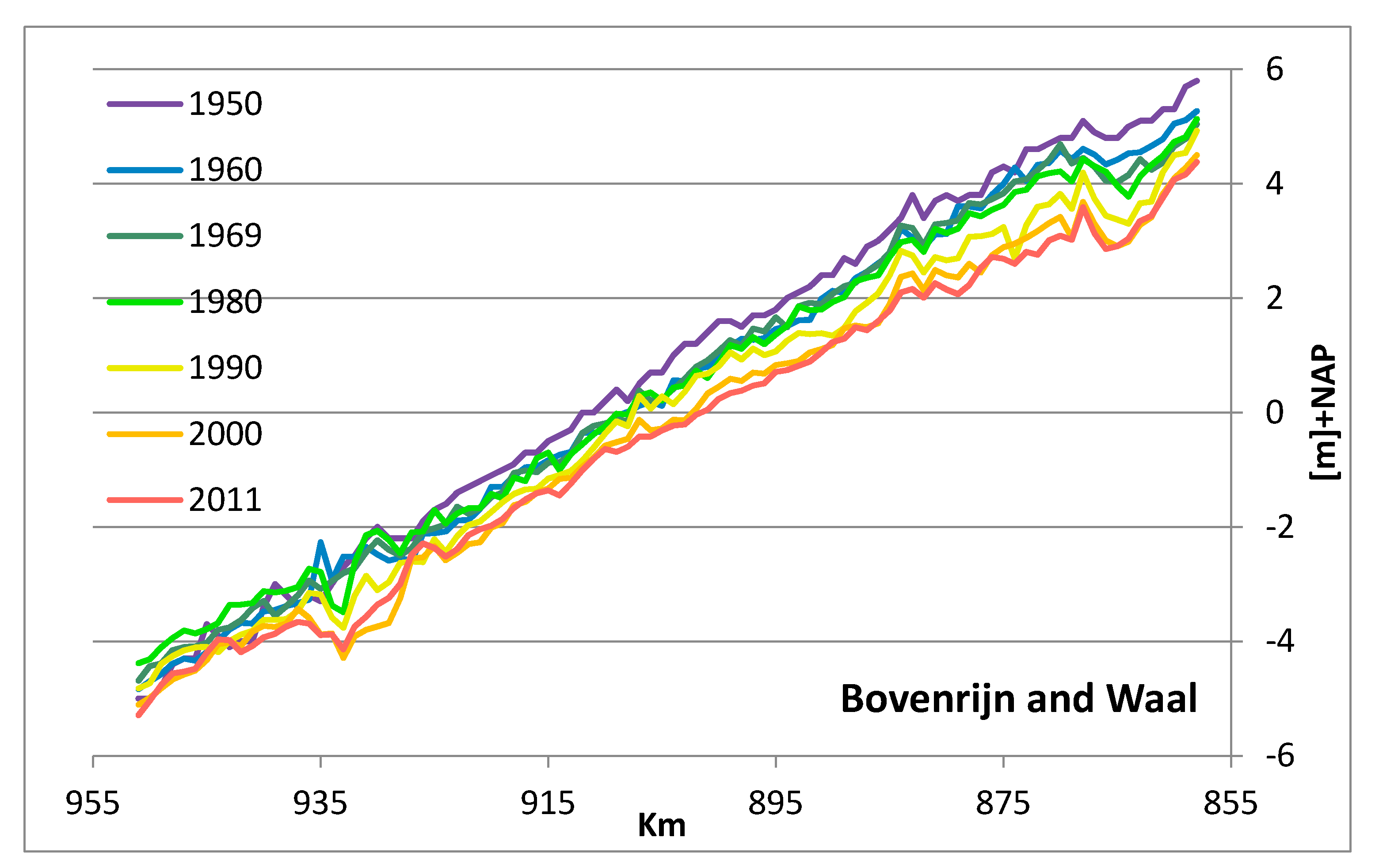
4.2. Continued Bed Erosion
4.2.1. Forecast of Bed Erosion
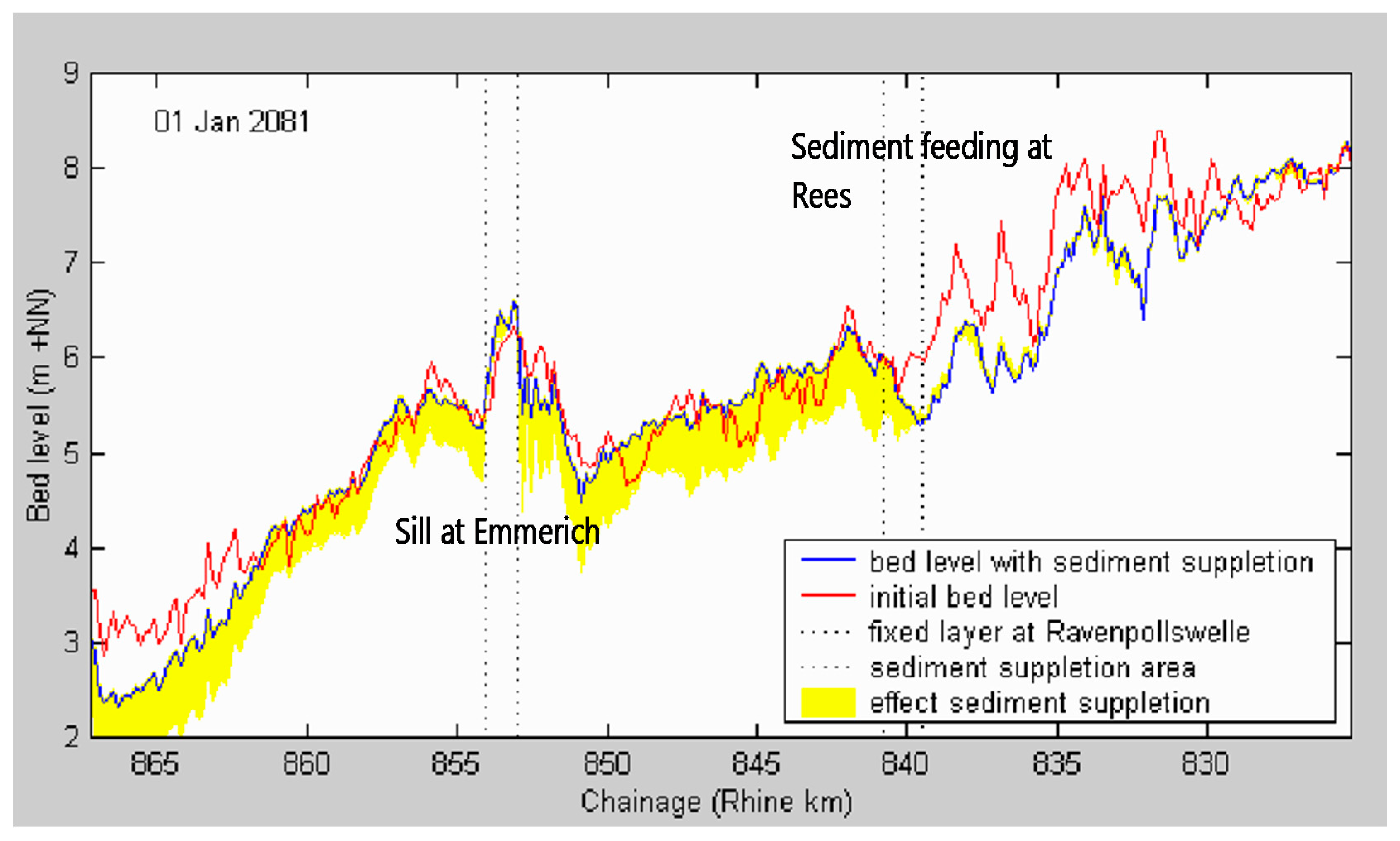
4.2.2. Possible Measures to Control Bed Erosion
4.2.3. Economic Effects of Continued Bed Erosion
- Bed erosion of the Bovenrijn by 0.6 m in 30 years (estimated from Table 4);
- Loss of load capacity, especially in the summer months—freight charge of €20/tonne (marketprice);
- Loss of transport capacity (Rotterdam−Ruhr): 48 million tonnes (4 times 12 million tonnes loss per 15 cm loss of water depth);
- Loss of transport capacity of 12 million occurs once every 10 years [27];
- On average, there is a loss of transport capacity of 6 million tonnes per year if it is assumed that this loss is linear with the frequency of occurrence;
- For an erosion of 0.6 m, there is then a loss of transport capacity of approximately 24 million tonnes per year (4 times 6 million tonnes).
4.3. Sustainable River Management of the Dutch Rhine River
5. Conclusions and Recommendations
5.1. Conclusions
- Historical development and recent sectoral improvement programs have shaped the Dutch Rhine river we see today. These recent programs include Room for the River, the Delta Program for Rivers, Sustainable Fairway Rhine Delta and the Water Framework Directive. They increasingly lead to conflicts between safety against flooding and riverine nature rehabilitation, thus calling for an integrated approach.
- Safety against flooding has been a leading element in river management of the past two centuries. The stable discharge distributions established at the end of the 18th century are the basis for equal flood protection conditions along all Rhine branches. Recently, the level of flood protection has been increased by implementing the Room for the River program. Increased flood protection has been achieved by lowering floodplains, removing summer dikes, creating secondary channels, as well as removing obstacles from the river bed.
- Inland waterway transport has benefitted from river regulation measures such as normalizations, widening the navigation channel in sharp bends and structural measures in bends, such as fixed layers and bendway weirs.
- Riverine nature has been rehabilitated by implementing European Water Framework Directive measures such as side channels and natural banks.
- An integrated approach to river management is demanded, as the measures to achieve the goals of the Room for the River program and the European Water Framework Directive increase the discharge capacity of floodplains and groyne fields, resulting in reduced velocities in the low-water bed and therefore local aggradation. These local shoals hamper inland navigation. The situation is exacerbated by the continuous bed erosion due to the three normalizations. Problems arise with respect to the coverage of crossing cables and pipes, the stability of structures (e.g., groynes) and the sailing depth above structures.
- The estimated depth reduction in 2050 of 0.6 m on the Waal river results in a loss of tonnage of approximately 15%. In an average climate scenario, this leads to average extra transport costs of approximately €480 million a year. In a dry climate scenario, the annual extra transport costs may amount to €960 million. On the contrary, strategies to stop bed erosion are relatively cheap: in 2007, the costs were estimated to approximately €200 million. Today, more far-reaching solutions with longitudinal training walls are considered, which will further increase costs.
- The work of Dutch government river engineers responsible for river management has taken on much more of a controlling nature, which has put the quality of the products under pressure.
5.2. Recommendations
- A fourth normalization with an integrated approach is required, using structural measures to stop large-scale bed erosion. The measures must be implemented urgently, and can be designed with the help of current 2D morphological models and research outputs of the RiverCare program.
- This fourth round of normalization works in the Rhine branches could efficiently mitigate the negative impact of recently executed works for improving flood protection and river ecology and may render river management more sustainable.
- Solutions for the Waal river with longitudinal training walls at both sides of the river, with a sailing width of approximately 100 m (instead of the actual 260 m) and very wide bank channels behind the walls, should be investigated as an extreme showcase to stop the bed erosion and increase the sailing depth largely.
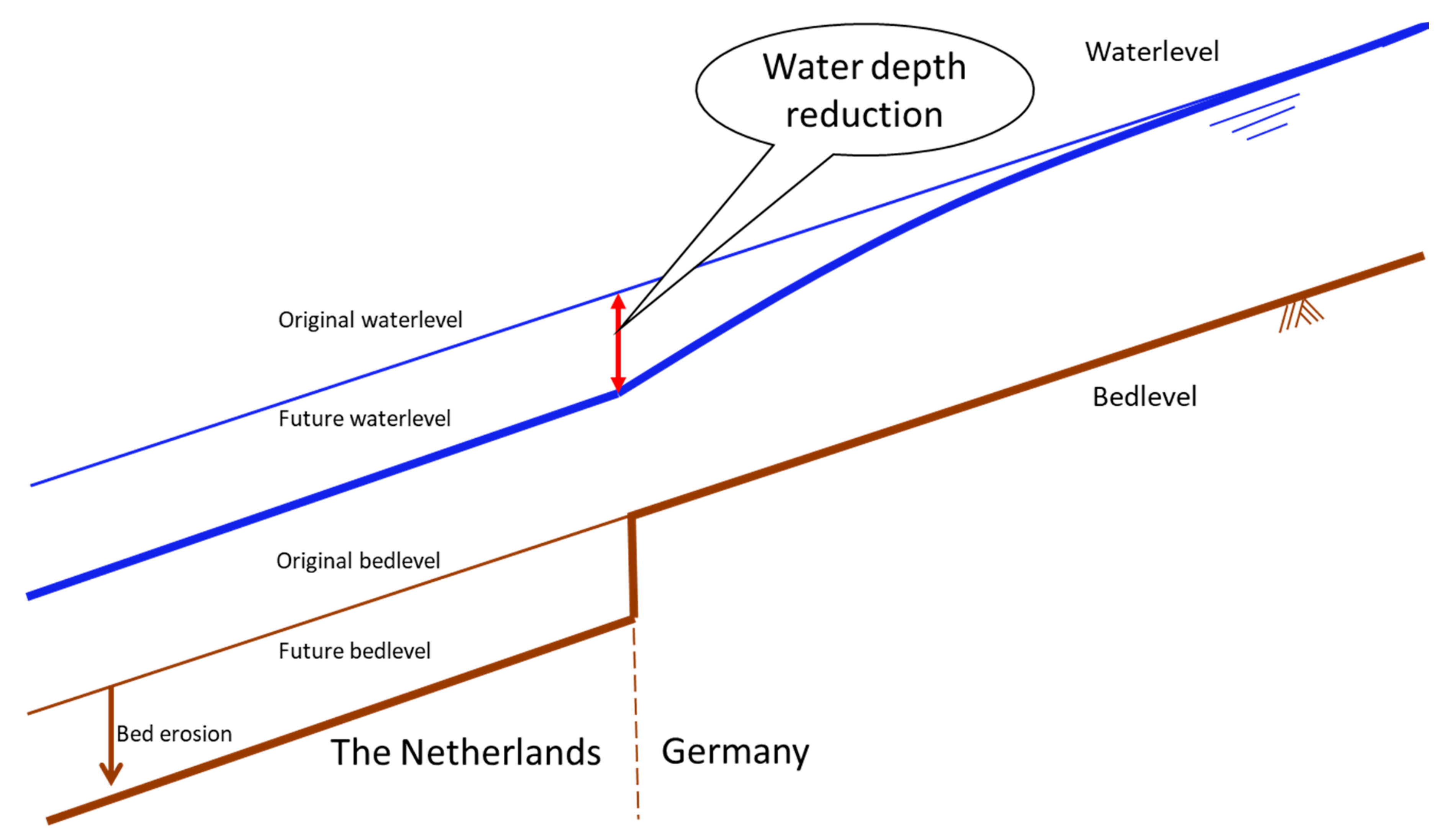
- Germany has already stabilized the eroding riverbed in the border reach of the Niederrhein river. In the Netherlands, stabilizing measures have been implemented only in the Dutch border region of the Bovenrijn river. To solve the transition problem, stabilizing works are demanded in the entire Waal river as well, to prevent the fall in water level at the border with a reduced waterdepth as a result.
- Geometric changes at bifurcation points have to be handled prudently because of possible effects on sand and water distributions, which in turn have effects on the most important user functions (flood protection, navigation, ecology and agriculture).
- A Dynamic River Management System should be implemented to control the impact of natural vegetation on actual flood water levels.
Funding
Acknowledgments
Conflicts of Interest
References
- Rijkswaterstaat. Space for River, Nature and People: Sustainable Floodplains along the Rhine; Dienst Oost-Nederland: Arnhem, The Netherlands, 2008.
- Smits, A.J.M.; Havinga, H.; Marteijn, E.C.L. New concepts in river and water management in the Rhine basin: How to live with the unexpected? In New Approaches to River Management; Smits, A.J.M., Nienhuis, P.H., Leuven, R.S.E.W., Eds.; Backhuys Publishers: Leiden, The Netherlands, 2000; pp. 119–139. [Google Scholar]
- Ploeger, B. Bouwen aan de Rijn. Menselijke Ingrepen op de Rijn en zijn Takken; Rijkswaterstaat Publication: The Hague, The Netherlands, 1992.
- Huisman, P.; Cramer, W.; Van Ee, G.; Hooghart, J.C.; Salz, H.; Zuidema, F.C. Water in The Netherlands; Netherlands Hydrologic Society: Delft, The Netherlands, 1999. [Google Scholar]
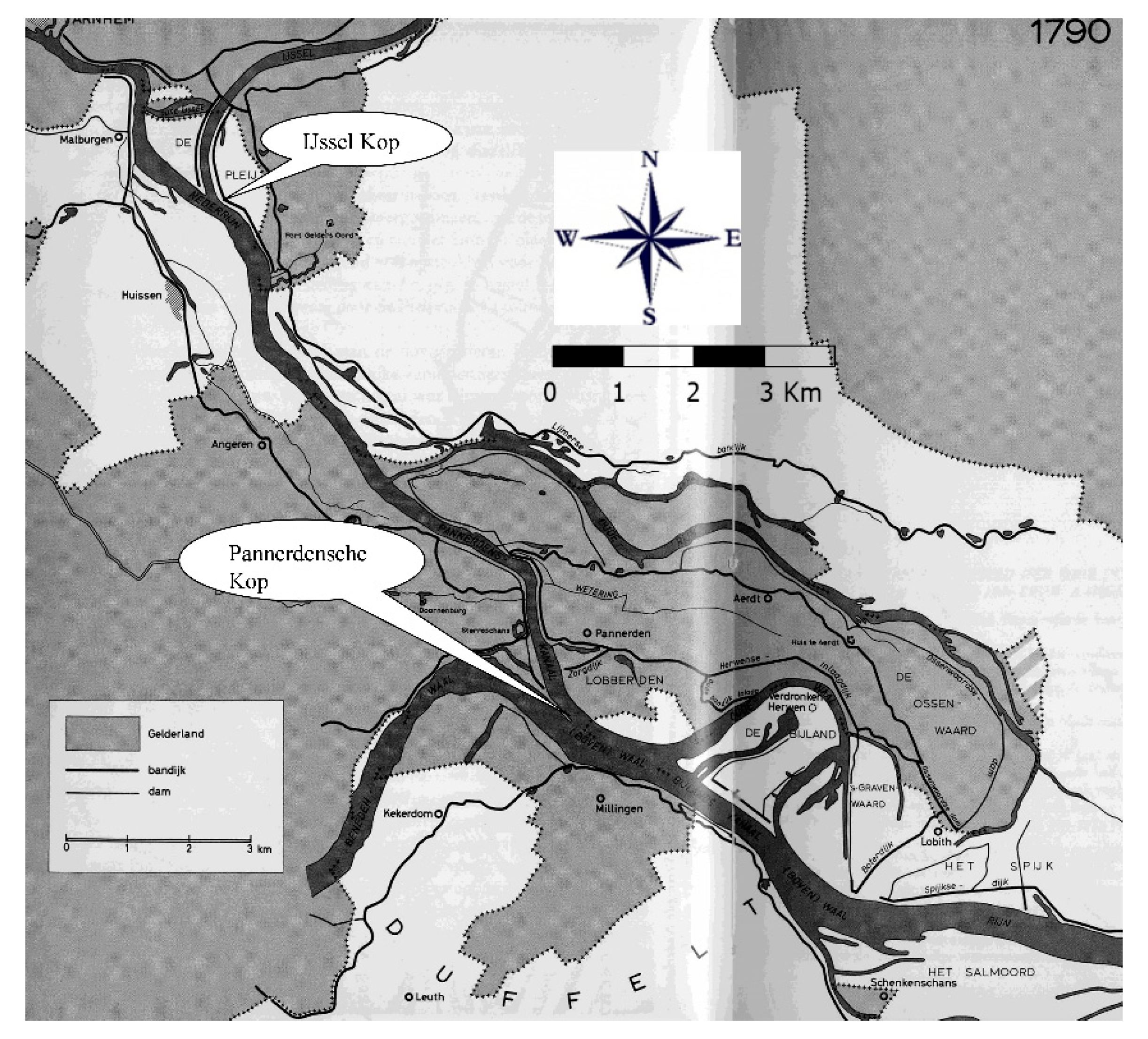
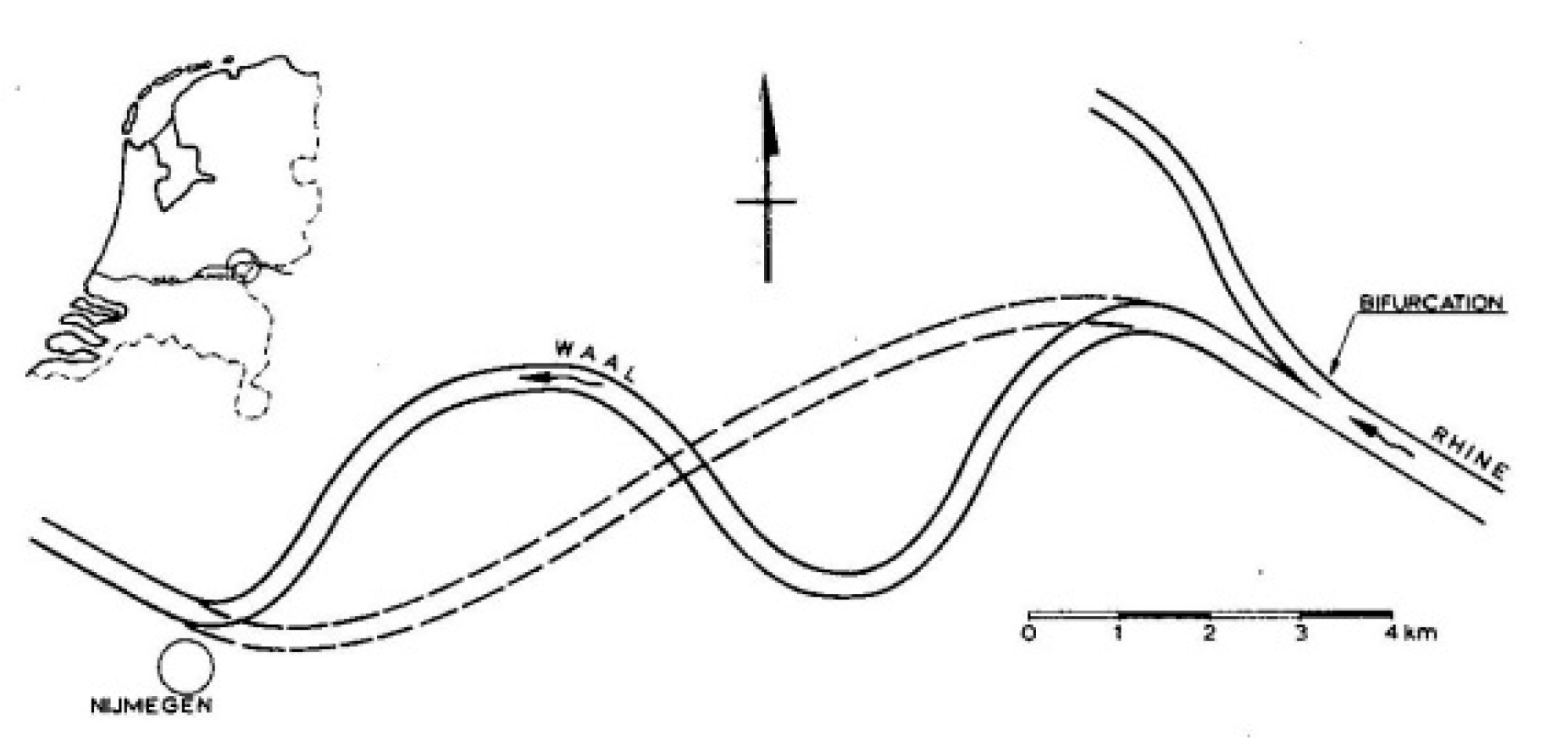
- Van de Ven, G.P. Aan de wieg van Rijkswaterstaat. Wordingsgeschiedenis van het Pannerdensch Kanaal; De Walburg Pers: Zutphen, The Netherlands, 1976. [Google Scholar]
- Buck, W.; Felkel, K.; Gerhard, H.; Kalweit, H.; van Malde, J.; Nippes, K.R.; Ploeger, B.; Schmitz, W. Der Rhein unter der Einwirkung des Menschen—Ausbau, Schifffahrt, Wasserwirtschaft. CHR Report I-11; CHR: Utrecht, The Netherlands, 1993. [Google Scholar]
- HKV. MIT-Verkenningennota. Duurzame Vaardiepte Rijndelta; HKV Report PR1151.10; HKV: Waterdienst, The Netherlands, 2007. [Google Scholar]
- Van Vuren, S.; Paarlberg, A.; Havinga, H. The aftermath of “Room for the River” and restoration works: Coping with excessive maintenance dredging. J. Hydro-Environ. Res. 2015, 9, 172–186. [Google Scholar] [CrossRef]
- European Commission. EU Water-Framework-Directive (WFD). In Official Journal (OJ L 327); European Commission: Ispra, Italy, 2000. [Google Scholar]
- WL|Delft Hydraulics. Rijn op Termijn; WL|Delft Hydraulics: Delft, The Netherlands, 1998. [Google Scholar]
- Smits, A.J.M.; Duel, H. Cyclische Verjonging van Uiterwaarden. Onderzoeksvoorstel in Het Kader van IRMA SPONGE Programma; Universiteit Nijmegen: Nijmegen, The Netherlands, 1999. [Google Scholar]
- Peters, B.; Kater, E.; Geerling, G. Cyclisch beheer in uiterwaarden. In Natuur en Veiligheid in de Praktijk; Radboud Universiteit: Nijimegen, The Netherlands, 2006. [Google Scholar]
- Bekendam, A.J.; Bos, M.; Blok, P.M.; de Boer, W.; Brolsma, J.U.; van der Burgh, J.; Deelen, C.; van Doorn, J.T.M.; Filarski, R.; Havinga, H.; et al. Six-barge pushtow trials. PIANC Bull. 1988, 62, 21–84. [Google Scholar]
- Rijkswaterstaat. Toekomstvisie Waal Hoofdtransportas Nota III. Eindrapportage; Directie Gelderland: Arnhem, The Netherlands, 1993. [Google Scholar]
- Havinga, H.; Stamm, J.; Roovers, G.; Fischenich, C. Sustainable Waterways within the Context of Navigation and Flood Management; PIANC, EnviCom Report 107; CRC Press: Boca Raton, FL, USA, 2009. [Google Scholar]
- WL|Delft Hydraulics. Fairway Improvement of the Bovenwaal, Scale Model Tests with Bottom Vanes; WL|Delft Hydraulics & Hydraulic and Sediment Research Institute (Cairo, Egypt): Delft, The Netherlands, 1995. [Google Scholar]
- Haskoning. Waal Hoofdtransportas: Detail Ontwerp Bodemschermen Hulhuizen; Haskoning: Nijmegen, The Netherlands, 1997. [Google Scholar]
- Waterloopkundig Laboratorium. Optimalisatie Lengte Bodemschermen; Rapport Q2418-98/I; Waterloopkundig Laboratorium: Delft, The Netherlands, 1998. [Google Scholar]
- Rijkswaterstaat. Toets Bodemschermen Hulhuizen. Analyse van de schermwerking, de aanvaarrisico’s en de maakbaarheid van bodemschermen in de Waal; Rijkswaterstaat Bouwdienst: Utrecht, The Netherlands, 2004. [Google Scholar]
- Haskoning. Waal Hoofdtransportas, Evaluatie Bodemschermen Fortmond m.b.v. het Axiaal-Symmetrische Model; Haskoning: Nijmegen, The Netherlands, 1996. [Google Scholar]
- De Vriend, H.J. Bodemschermen in Rivierbochten, Werking Vanuit Newtons Perspectief Gezien; Technische Universiteit Delft, faculteit Civiele Techniek: Delft, The Netherlands, 1996. [Google Scholar]
- Ghimire, B. No-Regret Solutions for Intakes for Secondary Channels. Master’s Thesis, International Institute for Infrastructural, Hydraulic and Environmental Engineering (IHE), Delft, The Netherlands, 2003. [Google Scholar]
- Rijkswaterstaat. Duurzame Vaardiepte Rijntakken (DVR2). In Studie Naar Problematiek en Mogelijke Aanpak van Bodemerosie en Aanzanding in Het Zomerbed van de Rijntakken in Oost-Nederland; RWS Oost-Nederland: Arnhem, The Netherlands, 2016. [Google Scholar]
- Sieben, A.J. Prognose Toekomstige Diepten in Kritische Vaarwegprofielen; Rijkswaterstaat-RIZA: Lelystad, The Netherlands, 2006. [Google Scholar]
- Waterloopkundig Laboratorium. Grensproject Bovenrijn, Report 4: Investigation of Combination of Engineering Measures with a 2-D Morphological Model; Report Q2496 Phase 4; Waterloopkundig Laboratorium: Delft, The Netherlands, 2003. [Google Scholar]
- Deltares. Morfologische pakketsom Waal: Morfologische effecten Ruimte voor de Rivier maatregelen; Deltares: Delft, The Netherlands, 2014. [Google Scholar]
- Bosschieter, C.G. Klimaatverandering en Binnenvaart; Port Research Centre Rotterdam-Delft: Rotterdam, The Netherlands, 2005; Available online: http://repository.tudelft.nl (accessed on 24 June 2020).
- Havinga, H. Visie op het rivierbeheer van de Rijn; Rijkswaterstaat: Arnhem, The Netherlands, 2016.
- Dutch Ministry of Infrastructure and Watermanagement. MIRT Onderzoek Duurzame Bodemligging Rijntakken; Bestuurskern DG Mobiliteit: The Hague, The Netherlands, 2018. [Google Scholar]
- RiverCare. Available online: https://kbase.ncr-web.org/rivercare/ (accessed on 24 June 2020).


| Intervention | Hydromorphological Reaction | Mitigating Measure |
|---|---|---|
| Drainage of peat areas in the Rhine delta | Oxidation of peat leads to subsidence on the land side of the dikes | Higher dikes and more powerful pumping stations in the polders |
| Regulation of river reaches and narrowing of the floodplains by dikes | Erosion of the river bed and lowering of the groundwater table. Higher flood peaks | Higher dikes |
| Function | Derived Goal | Geography | Defenses | Hydrology |
|---|---|---|---|---|
| Safety against flooding | Stability of flood defenses | Summer dikes Dikes Groynes | Stony structures Stone | Enforcement design flood levels and discharge distributions |
| Navigation | Maintaining channel dimensions | Summer dikes Large sailing depth | Stony structures Stone | Up to 4.0 m water depth: all discharge through main channel |
| Agriculture | Maintenance of area | Summer dikes Grass, no natural vegetation | Stony structures | No flooded floodplain |
| Ecology | More biodiversity through gentle land–water transitions | No summer dikes Secondary channels Natural vegetation | Soft defenses No stone | Often flooded floodplain |
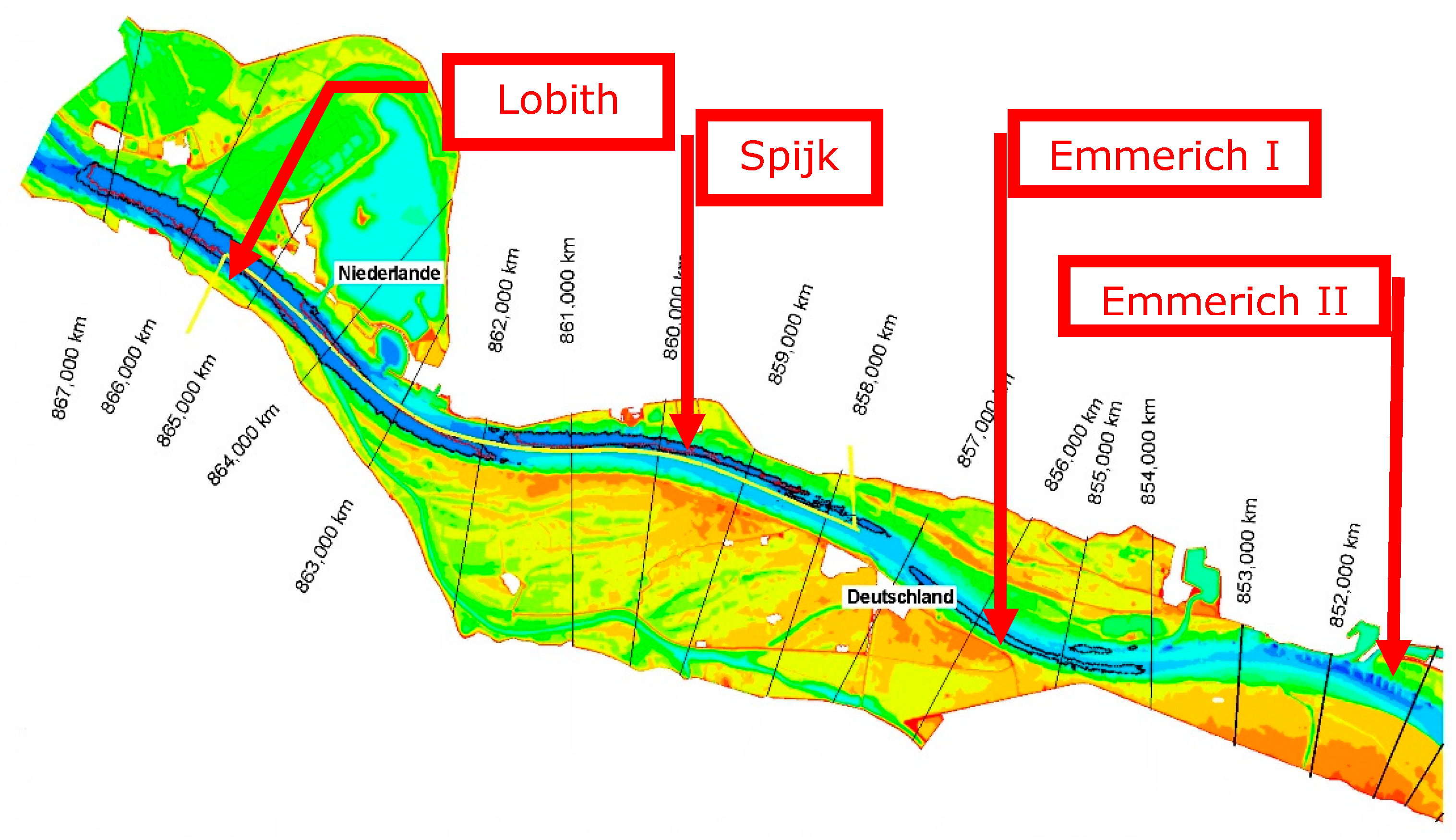
| Location | km | Type of Measure | Depth at ALD 2002 [m] | Depth at ALD 2032 [m] | Difference [m] |
|---|---|---|---|---|---|
| Emmerich | 856 | non-erodible bed | 2.72 | 2.12 to 2.27 | 0.5 to 0.6 |
| Erlecom | 875 | bendway weirs | 3.64 | 3.19 | 0.45 |
| Nijmegen | 885 | fixed layer | 3.34 | 2.89 | 0.45 |
| St. Andries | 926.5 | fixed layer | 3.63 | 3.37 | 0.26 |
| Period | 2010–2015 | 2015–2050 | 2050–2100 | 2010–2015 | 2015–2050 | 2050–2100 | |
|---|---|---|---|---|---|---|---|
| Branch | Location | Δz [m]/y | Δz [m]/y | Δz [m]/y | Δz w.r.t. 2010 [m] | Δz w.r.t. 2010 [m] | Δz w.r.t. 2010 [m] |
| Bovenrijn | Complete | −0.01 | −0.01 | −0.01 | −0.05 | −0.4 | −0.9 |
| Waal | Km 868 | −0.03 | −0.015 | −0.01 | −0.15 | −0.675 | −1.175 |
| Waal | Km 886 | −0.01 | −0.005 | −0.005 | −0.05 | −0.225 | −0.475 |
| Waal | Km 915 | −0.005 | −0.005 | −0.005 | −0.025 | −0.2 | −0.45 |
| Waal | Km 951 | 0 | 0 | 0 | 0 | 0 | 0 |
© 2020 by the author. Licensee MDPI, Basel, Switzerland. This article is an open access article distributed under the terms and conditions of the Creative Commons Attribution (CC BY) license (http://creativecommons.org/licenses/by/4.0/).
Share and Cite
Havinga, H. Towards Sustainable River Management of the Dutch Rhine River. Water 2020, 12, 1827. https://doi.org/10.3390/w12061827
Havinga H. Towards Sustainable River Management of the Dutch Rhine River. Water. 2020; 12(6):1827. https://doi.org/10.3390/w12061827
Chicago/Turabian StyleHavinga, Hendrik. 2020. "Towards Sustainable River Management of the Dutch Rhine River" Water 12, no. 6: 1827. https://doi.org/10.3390/w12061827
APA StyleHavinga, H. (2020). Towards Sustainable River Management of the Dutch Rhine River. Water, 12(6), 1827. https://doi.org/10.3390/w12061827