Numerical Modeling for the Accidental Dispersion of Hazardous Air Pollutants in the Urban Metropolitan Area


Abstract
1. Introduction
2. Experiments
2.1. Atmospheric Dispersion Model
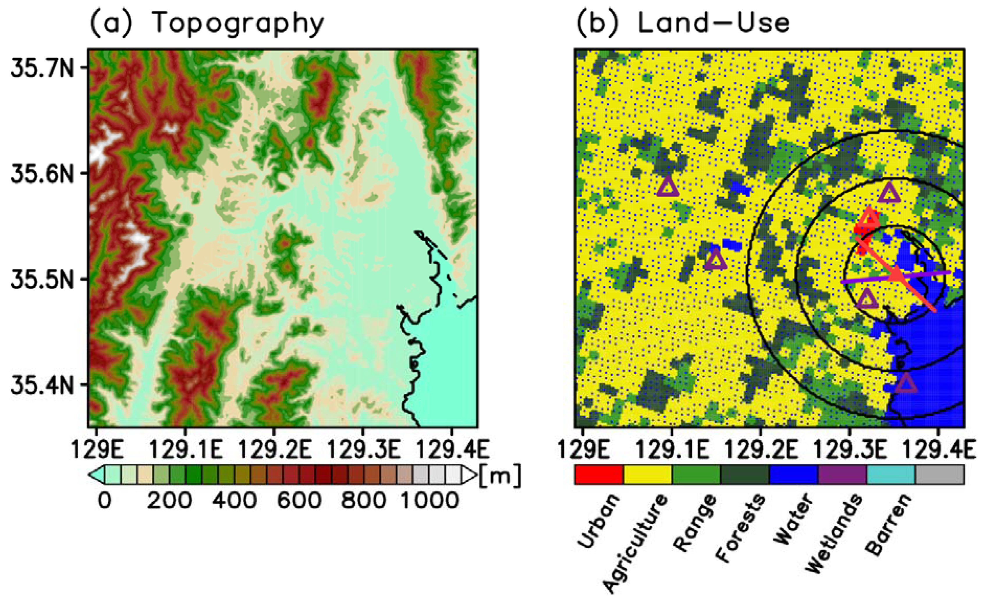
2.2. Experiment Settings
3. Results
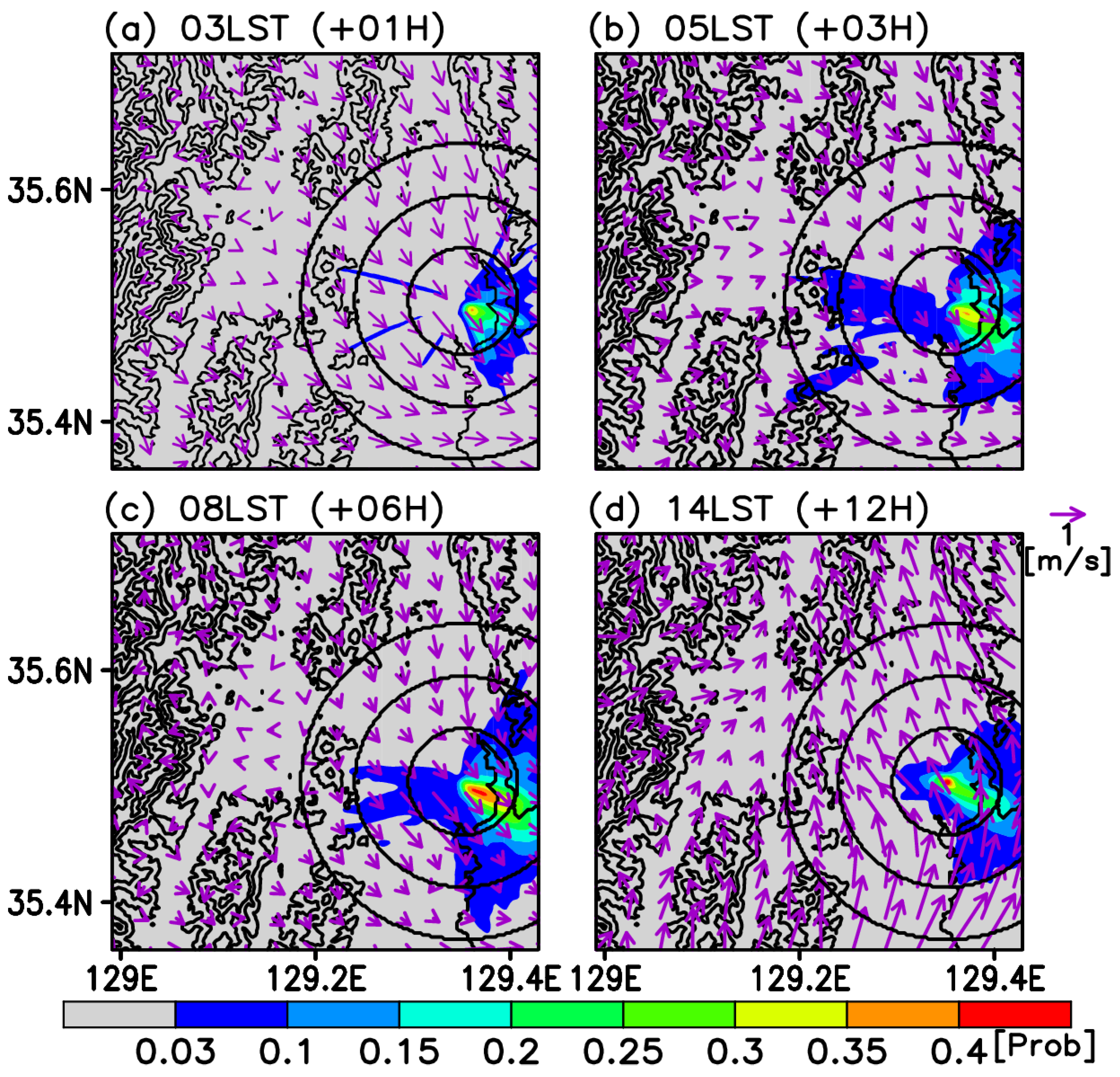
3.1. Validations for Wind and the Test Cases
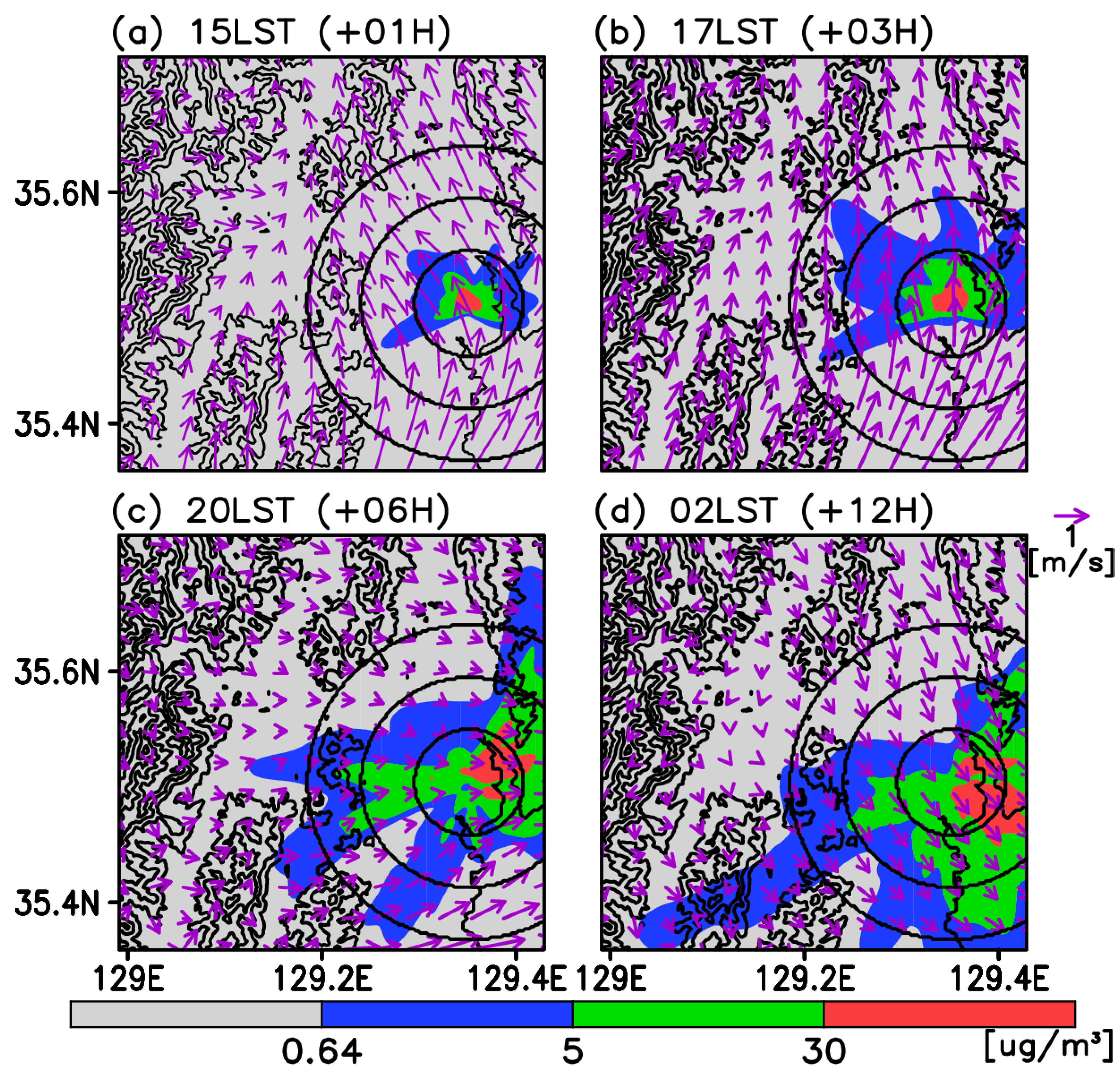
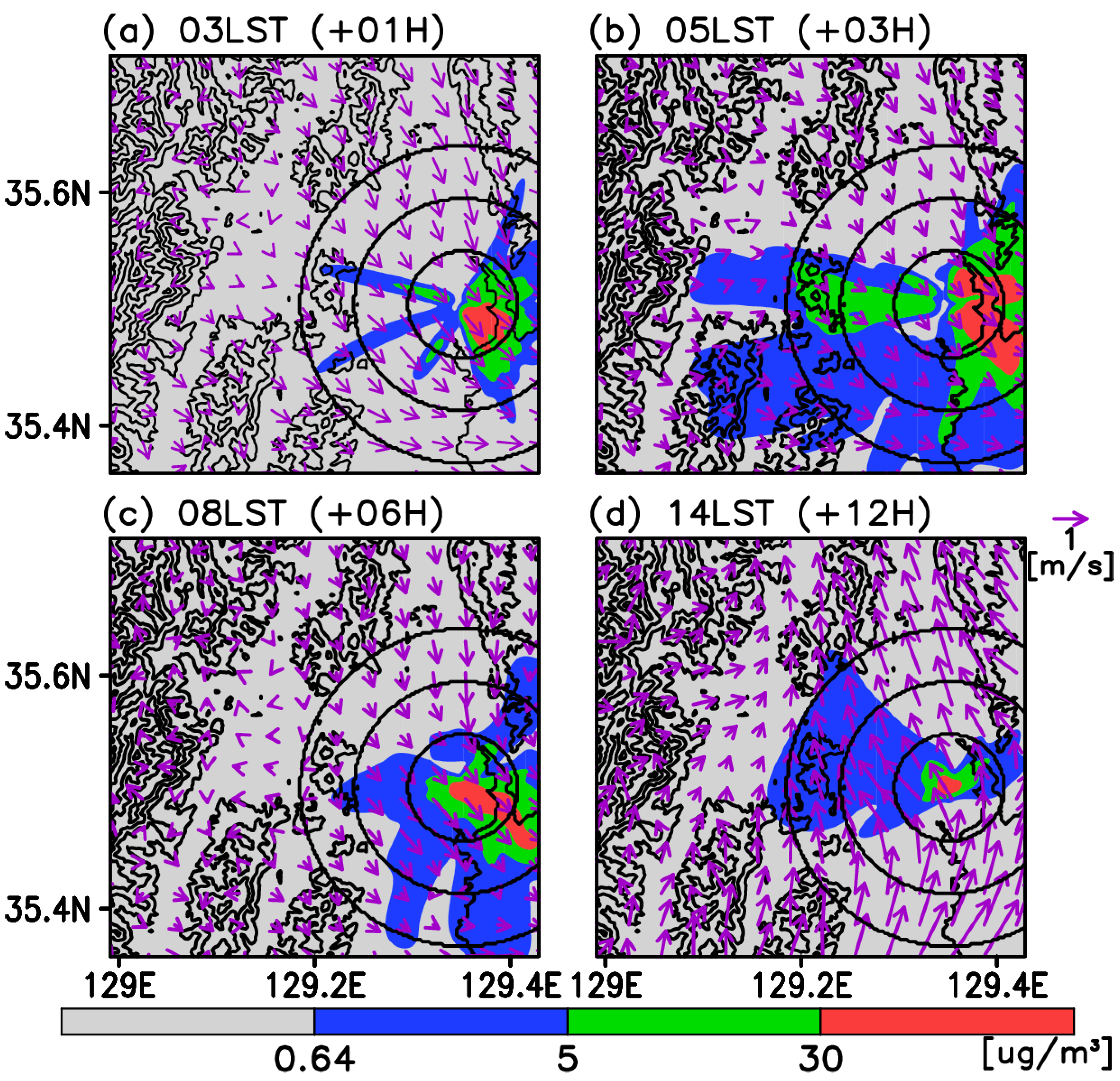
3.2. Time-Averaged Dispersion Pattern
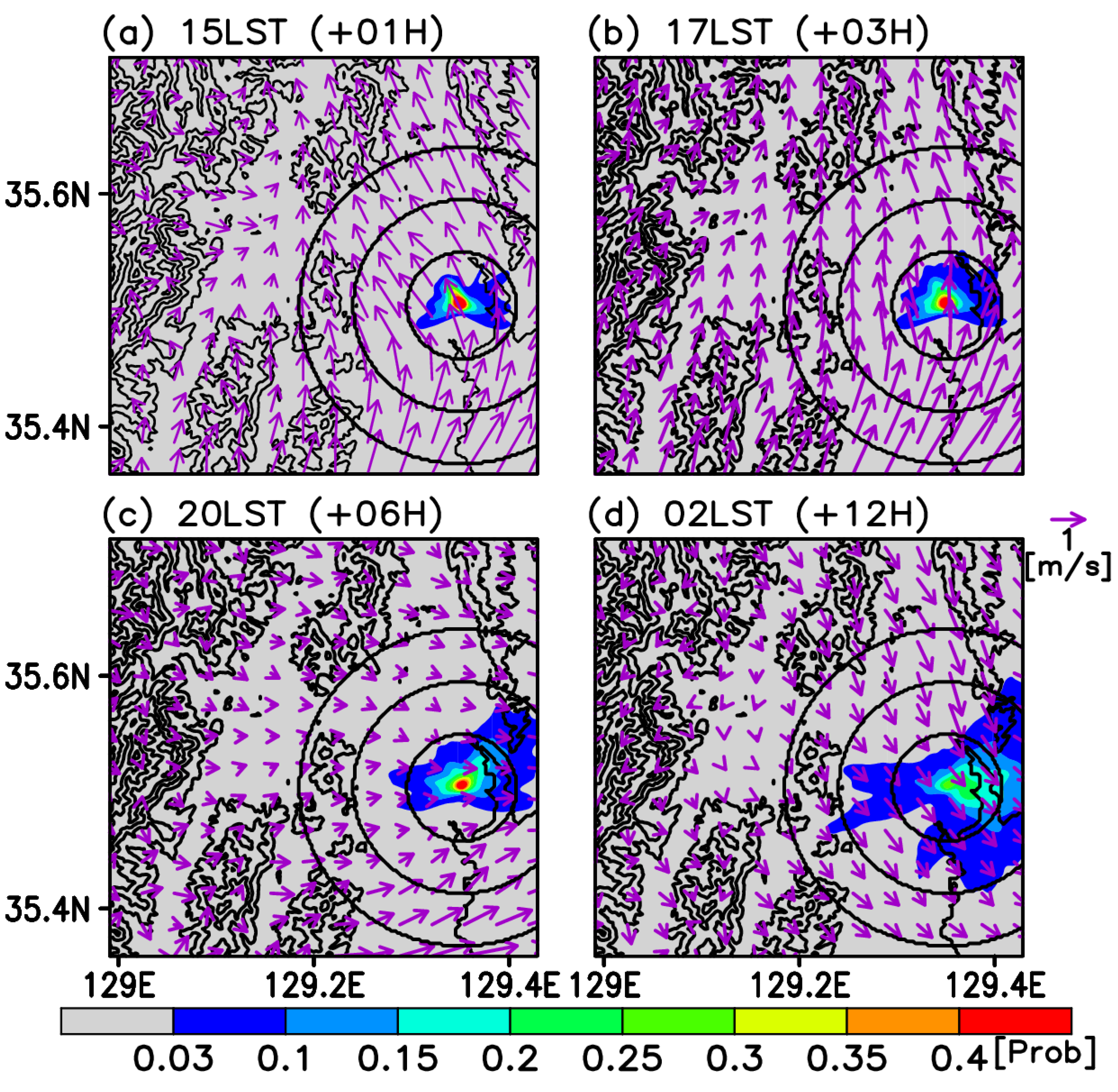
3.3. Risk Assessment
4. Discussion
5. Conclusions
Author Contributions
Funding
Acknowledgments
Conflicts of Interest
References
- Grimm, N.B.; Foster, D.; Groffman, P.; Grove, J.M.; Hopkinson, C.S.; Nadelhoffer, K.J.; Pataki, D.E.; Peters, D.P. The changing landscape: Ecosystem responses to urbanization and pollution across climatic and societal gradients. Front. Ecol. Environ. 2008, 6, 264–272. [Google Scholar] [CrossRef]
- Statistics Korea. Available online: http://www.index.go.kr/potal/stts/idxMain/selectPoSttsIdxSearch.do?idx_cd=4088&stts_cd=408802&freq=Y (accessed on 24 March 2020).
- Dabberdt, W.; Frederick, G.; Hardesty, R.; Lee, W.C.; Underwood, K. Advances in meteorological instrumentation for air quality and emergency response. Meteorol. Atmos. Phys. 2004, 87, 57–88. [Google Scholar] [CrossRef]
- Chen, W.K. Managing Emergency Response of Air Pollution by the Expert System. In Air Pollution–A Comprehensive Perspective; Hariyanto, B., Ed.; InTech: Rijeka, Croatia, 2012; p. 319. [Google Scholar]
- Jones, R.; Lehr, W.; Simecek-Beatty, D.; Reynolds, R.M. ALOHA® (Areal Locations of Harzadous Atmospheres) 5.4.4; Technical Documentation; NOAA Technical Memorandum NOS OR&R 43; U.S. Deptartment of Commerce: Washington, DC, USA, 2013; p. 96.
- Bruckner, J.V.; Keys, D.A.; Fisher, J.W. The Acute Exposure Guideline Level (AEGL) program: Applications of physiologically based pharmacokinetic modeling. J. Toxicol. Environ. Health Part A 2004, 67, 621–634. [Google Scholar] [CrossRef] [PubMed]
- Elbir, T. A GIS based decision support system for estimation, visualization and analysis of air pollution for large Turkish cities. Atmos. Environ. 2004, 38, 4509–4517. [Google Scholar] [CrossRef]
- Levy, J.I.; Spengler, J.D.; Hlinka, D.; Sullivan, D.; Moon, D. Using CALPUFF to evaluate the impacts of power plant emissions in Illinois: Model sensitivity and implications. Atmos. Environ. 2002, 36, 1063–1075. [Google Scholar] [CrossRef]
- Abdul-Wahab, S.; Sappurd, A.; Al-Damkhi, A. Application of California Puff (CALPUFF) model: A case study for Oman. Clean Tech. Environ. Policy 2011, 13, 177–189. [Google Scholar] [CrossRef]
- Abdul-Wahab, S.A.; Ali, S.; Sardar, S.; Irfan, N.; Al-Damkhi, A. Evaluating the performance of an integrated CALPUFF-MM5 modeling system for predicting SO2 emission from a refinery. Clean Tech. Environ. Policy 2011, 13, 841–854. [Google Scholar] [CrossRef]
- Tayanç, M.; Berçin, A. SO2 modeling in Izmit Gulf, Turkey during the winter of 1997: 3 cases. Environ. Model. Assess. 2007, 12, 119–129. [Google Scholar] [CrossRef]
- Dehghani, M.; Taghizadeh, M.M.; Hashemi, H.; Rastgoo, E. A Preliminary Assessment of Dispersion Level of SO2 in Fars Industrial Region, South of Iran, by GIS. J. Environ. Public Health 2013, 2013, 670590. [Google Scholar] [CrossRef]
- Ozkurt, N.; Sari, D.; Akalin, N.; Hilmioglu, B. Evaluation of the impact of SO2 and NO2 emissions on the ambient air-quality in the Çan–Bayramiç region of northwest Turkey during 2007–2008. Sci. Total Environ. 2013, 456, 254–266. [Google Scholar] [CrossRef]
- Prueksakorn, K.; Kim, T.H.; Vongmahadlek, C. Applications of WRF/CALPUFF modeling system and multi-monitoring methods to investigate the effect of seasonal variations on odor dispersion: A case study of Changwon City, South Korea. Air Qual. Atmos. Health 2014, 7, 13–27. [Google Scholar] [CrossRef]
- Ranzato, L.; Barausse, A.; Mantovani, A.; Pittarello, A.; Benzo, M.; Palmeri, L. A comparison of methods for the assessment of odor impacts on air quality: Field inspection (VDI 3940) and the air dispersion model CALPUFF. Atmos. Environ. 2012, 61, 570–579. [Google Scholar] [CrossRef]
- Venturini, E.; Vassura, I.; Ferroni, L.; Raffo, S.; Passarini, F.; Beddows, D.; Harrison, R.M. Bulk deposition close to a Municipal Solid Waste incinerator: One source among many. Sci. Total Environ. 2013, 456, 392–403. [Google Scholar] [CrossRef] [PubMed]
- Dias, D.; Tchepel, O. Modelling of human exposure to air pollution in the urban environment: A GPS-based approach. Environ. Sci. Pollut. Res. 2014, 21, 3558–3571. [Google Scholar] [CrossRef] [PubMed]
- Tartakovsky, D.; Broday, D.M.; Stern, E. Evaluation of AERMOD and CALPUFF for predicting ambient concentrations of total suspended particulate matter (TSP) emissions from a quarry in complex terrain. Environ. Pollut. 2013, 179, 138–145. [Google Scholar] [CrossRef]
- Barsotti, S.; Neri, A.; Scire, J. The VOL-CALPUFF model for atmospheric ash dispersal: 1. Approach and physical formulation. J. Geophys. Res. Solid Earth 2008, 113. [Google Scholar] [CrossRef]
- Scire, J.S.; Strimaitis, D.G.; Yamartino, R.J. Model Formulation and User’s Guide for the CALPUFF Dispersion Model; Sigma Research Corporation: Concord, MA, USA, 1990. [Google Scholar]
- Ghannam, K.; El-Fadel, M. Emissions characterization and regulatory compliance at an industrial complex: An integrated MM5/CALPUFF approach. Atmos. Environ. 2013, 69, 156–169. [Google Scholar] [CrossRef]
- Vieira de Melo, A.M.; Santos, J.M.; Mavroidis, I.; Reis Junior, N.C. Modelling of odour dispersion around a pig farm building complex using AERMOD and CALPUFF. Comparison with wind tunnel results. Build. Environ. 2012, 56, 8–20. [Google Scholar] [CrossRef]
- Abdul-Wahab, S.A.; Chan, K.; Elkamel, A.; Ahmadi, L. Effects of meteorological conditions on the concentration and dispersion of an accidental release of H2S in Canada. Atmos. Environ. 2014, 82, 316–326. [Google Scholar] [CrossRef]
- Indumati, S.; Oza, R.; Mayya, Y.; Puranik, V.; Kushwaha, H. Dispersion of pollutants over land–water–land interface: Study using CALPUFF model. Atmos. Environ. 2009, 43, 473–478. [Google Scholar] [CrossRef]
- Scire, J.S.; Strimaitis, D.G.; Yamartino, R.J. A User’s Guide for the CALPUFF Dispersion Model; Earth Tech, Inc.: Concord, MA, USA, 2000; pp. 1–521. [Google Scholar]
- Scire, J.S.; Robe, F.R.; Fernau, M.E.; Yamartino, R.J. A User’s Guide for the CALMET Meteorological Model; Version 5; Earth Tech, Inc.: Concord, MA, USA, 2000; p. 37. [Google Scholar]
- Korean Ministry of Environment. Guidelines for Initial Risk Assessment Using Chemical Emission Information; Ministry of Environment: Sejong, Korea; National Institute of Environmental Research: Inchon, Korea; pp. 1–111. (In Korean)
- PRTR Information System. Available online: https://icis.me.go.kr/prtr/main.do (accessed on 24 March 2020).
- Chemical Information System. Available online: https://icis.me.go.kr/main.do (accessed on 24 March 2020).
- Huang, G.; Gao, L.; Duncan, J.; Harper, J.D.; Sanders, N.L.; Ouyang, Z.; Cooks, R.G. Direct detection of benzene, toluene, and ethylbenzene at trace levels in ambient air by atmospheric pressure chemical ionization using a handheld mass spectrometer. J. Am. Soc. Mass Spectrom. 2010, 21, 132–135. [Google Scholar] [CrossRef] [PubMed]
- Integrated Risk Information System. Available online: https://www.epa.gov/iris (accessed on 24 March 2020).
- IRIS Benzene Chemical Assessment Summary. Available online: https://cfpub.epa.gov/ncea/iris/iris_documents/documents/subst/0276_summary.pdf (accessed on 24 March 2020).
- Deardorff, J.W. Three-dimensional numerical study of the height and mean structure of a heated planetary boundary layer. Bound. Layer Meteorol. 1974, 7, 81–106. [Google Scholar] [CrossRef]
- U.S. Department of Transportation. 2016 Emergency Response Guidebook. Available online: https://www.phmsa.dot.gov/sites/phmsa.dot.gov/files/docs/ERG2016.pdf (accessed on 24 March 2020).


| Diffusivity (cm2 s−1) | 0.1509 |
| Aqueous Dissociation Constant | 1.0 |
| Reactivity | 8.0 |
| Mesophyll Resistance (s cm−1) | 0.0 |
| Henry’s Law | 4.0 × 10⁻² |
| Date | Time of Accident (LST in hh mm) | Duration | Pollutant | Emission Amount (kg) | Approx. Emission Rate (kg h−1) |
|---|---|---|---|---|---|
| 25 February 2014 | 14:47 | 30 min | Hydrofluoric Acid | 115 | 230 |
| 13 February 2014 | 13:00 | 2 h 50 min | Ammonia | 1500 | 530 |
| 3 January 2014 | 04:00 | 17 h | Propane | 40,000 | 2350 |
| 13 October 2013 | 21:00 | 20 min | Benzene | 438 | 1300 |
| 16 July 2013 | 05:04 | 20 min | Chlorosurfonic Acid | 3.5 | 10.5 |
| 9 June 2013 | 22:30 | 5 h | Hydrochloric Acid | 236 | 47.2 |
| 27 September 2012 | 15:43 | 12 h | Hydrofluoric Acid | 8000 | 667 |
| 4 July 2008 | 12:50 | 2 h 30 min | Benzene | 22,000 | 8800 |
| 16 October 2007 | 10:00 | At least 3 h | Benzene | Unknown | Unknown |
© 2020 by the authors. Licensee MDPI, Basel, Switzerland. This article is an open access article distributed under the terms and conditions of the Creative Commons Attribution (CC BY) license (http://creativecommons.org/licenses/by/4.0/).
Share and Cite
Kim, G.; Lee, M.-I.; Lee, S.; Choi, S.-D.; Kim, S.-J.; Song, C.-K. Numerical Modeling for the Accidental Dispersion of Hazardous Air Pollutants in the Urban Metropolitan Area. Atmosphere 2020, 11, 477. https://doi.org/10.3390/atmos11050477
Kim G, Lee M-I, Lee S, Choi S-D, Kim S-J, Song C-K. Numerical Modeling for the Accidental Dispersion of Hazardous Air Pollutants in the Urban Metropolitan Area. Atmosphere. 2020; 11(5):477. https://doi.org/10.3390/atmos11050477
Chicago/Turabian StyleKim, Ganghan, Myong-In Lee, Seunghee Lee, Sung-Deuk Choi, Sung-Joon Kim, and Chang-Keun Song. 2020. "Numerical Modeling for the Accidental Dispersion of Hazardous Air Pollutants in the Urban Metropolitan Area" Atmosphere 11, no. 5: 477. https://doi.org/10.3390/atmos11050477
APA StyleKim, G., Lee, M.-I., Lee, S., Choi, S.-D., Kim, S.-J., & Song, C.-K. (2020). Numerical Modeling for the Accidental Dispersion of Hazardous Air Pollutants in the Urban Metropolitan Area. Atmosphere, 11(5), 477. https://doi.org/10.3390/atmos11050477