You are currently viewing a new version of our website. To view the old version click .

Remote Sensing, Volume 9, Issue 4

April 2017 - 96 articles

Cover Story: 
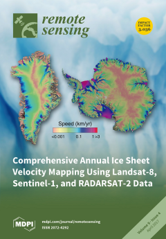
Ice sheets hold the largest potential for sea level rise in the upcoming decades to centuries and represent the largest source of uncertainty for projections. Ice sheet surface velocity is a fundamental observable aspect of their dynamics that has only recently become available from space. This provides essential information for assessments of past, current and future contributions to sea level, and our understanding of the physics of ice flow. In this issue, Mouginot et al., funded through the NASA’s MEaSUREs program, have developed a new methodology to fuse multisensor data sources, including CSA's RADARSAT-2, ESA's Sentinel-1 and USGS's Landsat-8, to form coherent and comprehensive time series of ice velocity over the entire Antarctic and Greenland ice sheets. These measurements of ice motion over the ice sheets provide a quantum leap improvement of observational constraints for ice sheet numerical models. View this paper.

Articles (96)

  • Article
  • Open Access
45 Citations
7,878 Views
24 Pages

20 April 2017

Actual evapotranspiration (ET) is a major water use flux in a basin water balance with crucial significance for water resources management and planning. Mapping ET with good accuracy has been the subject of ongoing research. Such mapping is even more...

  • Article
  • Open Access
65 Citations
10,259 Views
16 Pages

InSAR Time-Series Analysis of Land Subsidence under Different Land Use Types in the Eastern Beijing Plain, China

  • Chaofan Zhou,
  • Huili Gong,
  • Beibei Chen,
  • Jiwei Li,
  • Mingliang Gao,
  • Feng Zhu,
  • Wenfeng Chen and
  • Yue Liang

19 April 2017

In the Beijing plain, the long-term groundwater overexploitation, exploitation, and the utilization of superficial urban space have led to land subsidence. In this study, the spatial–temporal analysis of land subsidence in Beijing was assessed by usi...

  • Article
  • Open Access
11 Citations
6,257 Views
16 Pages

Parallel Agent-as-a-Service (P-AaaS) Based Geospatial Service in the Cloud

  • Xicheng Tan,
  • Song Guo,
  • Liping Di,
  • Meixia Deng,
  • Fang Huang,
  • Xinyue Ye,
  • Ziheng Sun,
  • Weishu Gong,
  • Zongyao Sha and
  • Shaoming Pan

19 April 2017

To optimize the efficiency of the geospatial service in the flood response decision making system, a Parallel Agent-as-a-Service (P-AaaS) method is proposed and implemented in the cloud. The prototype system and comparisons demonstrate the advantages...

  • Article
  • Open Access
17 Citations
5,752 Views
29 Pages

19 April 2017

This paper presents a novel semi-supervised joint dictionary learning (S2JDL) algorithm for hyperspectral image classification. The algorithm jointly minimizes the reconstruction and classification error by optimizing a semi-supervised dictionary lea...

  • Article
  • Open Access
29 Citations
5,695 Views
17 Pages

19 April 2017

Soil moisture (SM) retrieval from SMOS (the Soil Moisture and Ocean Salinity mission) and SMAP (the Soil Moisture Active/Passive mission) passive microwave data over forested areas with required accuracy is of great significance and poses some challe...

  • Article
  • Open Access
44 Citations
7,000 Views
20 Pages

Examining Spatial Distribution and Dynamic Change of Urban Land Covers in the Brazilian Amazon Using Multitemporal Multisensor High Spatial Resolution Satellite Imagery

  • Yunyun Feng,
  • Dengsheng Lu,
  • Emilio F. Moran,
  • Luciano Vieira Dutra,
  • Miquéias Freitas Calvi and
  • Maria Antonia Falcão De Oliveira

19 April 2017

The construction of the Belo Monte hydroelectric dam began in 2011, resulting in rapidly increased population from less than 80,000 persons before 2010 to more than 150,000 persons in 2012 in Altamira, Pará State, Brazil. This rapid urbanization has...

  • Article
  • Open Access
20 Citations
10,805 Views
19 Pages

19 April 2017

Sound navigating and ranging (SONAR) detection systems can provide valuable information for navigation and security, especially in shallow coastal areas. The last few years have seen an important increase in the volume of bathymetric data produced by...

  • Article
  • Open Access
16 Citations
6,331 Views
21 Pages

A Recognition and Geological Model of a Deep-Seated Ancient Landslide at a Reservoir under Construction

  • Shengwen Qi,
  • Yu Zou,
  • Faquan Wu,
  • Changgen Yan,
  • Jinghui Fan,
  • Mingdong Zang,
  • Shishu Zhang and
  • Ruyi Wang

19 April 2017

Forty-six ancient Tibetan star-shaped towers and a village are located on a giant slope, which would be partially flooded by a nearby reservoir currently under construction. Ground survey, boreholes, and geophysical investigations have been carried o...

  • Article
  • Open Access
51 Citations
11,033 Views
23 Pages

Capturing the Diversity of Deprived Areas with Image-Based Features: The Case of Mumbai

  • Monika Kuffer,
  • Karin Pfeffer,
  • Richard Sliuzas,
  • Isa Baud and
  • Martin Van Maarseveen

19 April 2017

Many cities in the Global South are facing rapid population and slum growth, but lack detailed information to target these issues. Frequently, municipal datasets on such areas do not keep up with such dynamics, with data that are incomplete, inconsis...

  • Article
  • Open Access
109 Citations
13,114 Views
21 Pages

In-Field High-Throughput Phenotyping of Cotton Plant Height Using LiDAR

  • Shangpeng Sun,
  • Changying Li and
  • Andrew H. Paterson

18 April 2017

A LiDAR-based high-throughput phenotyping (HTP) system was developed for cotton plant phenotyping in the field. The HTP system consists of a 2D LiDAR and an RTK-GPS mounted on a high clearance tractor. The LiDAR scanned three rows of cotton plots sim...

of 10

Get Alerted

Add your email address to receive forthcoming issues of this journal.

XFacebookLinkedIn
Remote Sens. - ISSN 2072-4292