Highlights
What are the main findings?
- KLIMA, a physically based FORTRAN line-by-line radiative transfer model, and the fast radiative transfer model SIGMA exhibit good agreement in cloudy-sky simulations when the same cloud scattering parametrization (Chou approximation) is adopted in both models.
- The agreement previously observed under clear-sky conditions is therefore largely preserved in the presence of liquid-water and ice clouds, particularly when both models employ a consistent atmospheric path length.
What are the implications of the main findings?
- The applicability of KLIMA is extended from clear-sky to all-sky radiative transfer simulations.
- This mixed modeling approach enables different levels of computational efficiency and accuracy: high accuracy in clear-sky conditions, efficient simulations in cloudy atmospheres.
Abstract
In recent times, increasing attention has been devoted to the investigation of atmospheric processes through remote sensing in order to improve our understanding of climate dynamics and atmospheric physics. This requires accurate simulation of the spectra emitted by the Earth, from which atmospheric composition and thermodynamic conditions can be retrieved. The FORUM mission focuses on observations of the Earth’s outgoing radiation in the far-infrared spectral region, which has been only sparsely explored due to observational challenges, despite its significant contribution to the characterization of atmospheric processes. As part of the mission activities, dedicated simulations of the measurements expected from the FORUM instrument are required. Different models and codes can be employed for this purpose. Fast radiative transfer models, such as SIGMA-FORUM, efficiently simulate all-sky conditions, whereas detailed line-by-line models, such as KLIMA, have generally been limited to clear-sky applications. In this context, SIGMA-FORUM, an all-sky fast radiative transfer model operating in the 10–2760 cm−1 spectral range and KLIMA, a FORTRAN-based line-by-line algorithm extensively validated under clear-sky conditions, are used to simulate FORUM radiances in both clear and cloudy atmospheres. This study extends the comparison between SIGMA-IASI/F2N and KLIMA to cloudy-sky scenarios by incorporating cloud optical properties into KLIMA using the same parametrization approach adopted in SIGMA-FORUM version 2.4. By combining complementary modeling approaches, this work enables KLIMA to simulate atmospheric radiances under all-sky conditions, thereby broadening its applicability.
1. Introduction
An essential aspect of remote sensing in Earth observation is the physical interpretation of satellite measurements. This interpretation is based on forward physical models capable of reproducing the observed radiances. Inverse modeling approaches are rigorously formulated in the optimal estimation framework [1,2] and have been widely adopted in remote sensing retrieval algorithms (e.g., [3,4]). The radiation emitted by the Earth and observed by satellite can be simulated using a radiative transfer model (RTM) [5], which describes the interaction between radiation and matter in the Earth’s atmosphere and the transfer of radiation from the Earth’s surface to space. The comparison between high-resolution radiance data -acquired through satellite observations and synthetic spectra created on the basis of a RTM [4]-is fundamental for interpreting observations and for improving our understanding of atmospheric processes. Until now, the observation of far-infrared (FIR) radiation from space has been limited by a substantial observational gap, which has limited our understanding of the Earth’s climate system. The FIR region plays a crucial role in the planet’s energy budget, particularly through the continuum absorption of water vapor, the radiative properties of cirrus clouds, and the emissivity of ice- and snow-covered surfaces. However, the technological challenges involved in achieving accurate measurements in this spectral range -such as high radiometric accuracy, thermal stability, and complex calibration- have long delayed progress. Only recently have advances in instrumentation, detector sensitivity, and calibration techniques made it feasible to observe the FIR from space with the required precision. The FORUM mission (Far-Infrared Outgoing Radiation Understanding and Monitoring) thus marks a major milestone by bridging this long-standing observational gap and enabling more reliable climate predictions [6]. Consequently, despite the scientific relevance of detecting and analyzing OLR, only a limited number of space missions have targeted this spectral range—especially in the long-wave domain [7]. Recent studies have highlighted the sensitivity of far-infrared measurements to cirrus clouds and upper tropospheric water vapor, which significantly affect the Earth’s energy budget [8]. The FORUM mission [9], selected to be the 9th Earth Explorer of the European Space Agency, was designed to fill the current knowledge and observational gap in the FIR region, and to enhance our understanding of the climate system. Together with measurements carried out by the IASI-NG (Infrared Atmospheric Sounding Interferometer–New Generation, developed by CNES, Toulouse, France, and EUMETSAT, Darmstadt, Germany), FORUM will enable full spectral coverage of Earth’s OLR—from 100 to 2760 cm−1. Specifically, FORUM will measure thermal radiation between 100 and 1600 cm−1, with a spectral resolution of 0.5 cm−1, while IASI-NG will cover the 645 and 2760 cm−1 spectral range with a spectral resolution of 0.25 cm−1. These measurements will be fundamental for an accurate understanding of the overall balance of terrestrial radiation [8] and of the physical processes underlying climate change. In this sense, the goal is to determine the sensitivity of the measurements to atmospheric and surface parameters, and to quantify the error with which those parameters can be derived from the measurement.
During the preparatory phase of the satellite mission, it is crucial to determine how the instrument’s measurements should be interpreted. To this end, synthetic spectra are generated using RTMs based on spectroscopic databases, an assumption of the atmospheric and surface state and an instrument response function. These RTMs include line-by-line codes such as LBLRTM [10] and KLIMA [11], as well as fast, parametric codes such as σ−IASI/F2N [12,13], which we will refer to as SIGMA for brevity throughout the text. The KLIMA code can simulate and analyze remote sensing atmospheric spectral radiances acquired under clear sky conditions. It supports various viewing geometries (limb, zenith and nadir) and spectral domains ranging from millimeter and sub-millimeter waves to the near-infrared. KLIMA operates through two main modules: the forward model (FM) and the retrieval model (RM). KLIMA FM is a line-by-line radiative transfer algorithm capable of modeling a multilayered spherical atmosphere and simulating broadband spectral radiances. KLIMA, extensively validated through inter-comparison with LBLRTM and mono-LBLRTM [11], offers high accuracy but is restricted to clear sky simulations. This feature significantly limits the applicability of this code, as a large fraction of spectral measurements acquired from satellite is affected by clouds. SIGMA, in contrast, is a forward model that supports all sky radiative transfer simulations in the 10 to 2760 cm−1 range. It computes the radiances using an original parametrization of the optical depth of atmospheric gases and cloud properties. The cloud parametrization relies on scaling laws that make the radiative transfer equation in cloudy atmospheres formally equivalent to that in clear sky [12,13]. The SIGMA code, originally developed at the University of Basilicata [14] provides slightly lower spectral accuracy compared to line-by-line models but enables efficient simulations of the emission of the Earth’s atmosphere in all-sky conditions as the atmospheric model takes scattering into account.
To overcome the above described limitation of KLIMA, we implemented the cloud model (including both water and ice clouds) used in SIGMA into KLIMA and we verified whether the agreement found between SIGMA and KLIMA in clear sky scenarios [15] could be extended to cloudy conditions. In the next section we briefly describe the codes used, we report the methodology adopted to simulate spectra for representative scenarios, and we evaluate the comparison results in terms of statistical analysis of the differences. Finally, conclusions are reported in the Section 8.
2. The FORUM Mission and Products
FORUM, recently selected as ESA’s ninth Earth Explorer mission and scheduled for launch in 2027, is an exploratory mission designed to close a critical observational gap in the Earth’s emission spectrum. Approximately 99% of the Earth’s thermal radiation lies within the outgoing longwave radiation (OLR) spectral range (100–2500 cm−1). A substantial fraction of this radiation, about half, originates from the far-infrared (FIR, 100–667 cm−1). Despite its importance, the contribution of the FIR to the OLR has never been comprehensively measured from space due to technological limitations, resulting in significant uncertainties in our understanding of its role in the Earth’s energy budget.
The primary goal of FORUM is to measure the FIR portion of the Earth’s emitted spectrum with high spectral resolution and absolute radiometric accuracy. This will enable the scientific community to place improved constraints on the physical processes governing atmospheric radiative transfer and climate feedback mechanisms, thereby enhancing the performance and reliability of climate models. The lack of FIR observations has so far limited our ability to quantify key processes, such as the greenhouse effect of water vapor, its modulation by clouds, in particular, high-altitude ice clouds, and the influence of surface emissivity. FORUM will provide enhanced information on the vertical distribution of atmospheric water vapor, absorption mechanisms under different climate conditions (in particular in hot and humid regions), and cloud microphysical properties. At high latitudes, where the atmosphere is relatively transparent in the FIR, FORUM will also enable the characterization of surface longwave emission, including the emissivity of snow- and ice-covered surfaces [9].
2.1. Instruments and Measurement Concept
The FORUM payload will fly in loose formation with IASI-NG on the MetOp-SG-A1 satellite, thereby providing complementary FIR and MIR measurements [16]. Two instruments are part of the FORUM mission:
- The FORUM Sounding Instrument (FSI), a nadir-viewing Fourier Transform Spectrometer (FTS) measuring upwelling spectral radiance in the 100–1600 cm−1 range, with an unapodized spectral resolution of 0.5 cm−1. The FSI has a single circular footprint of approximately 15 km diameter, with along-track sampling slightly below 100 km.
- FORUM Embedded Imager (FEI), a co-aligned thermal imager with a single channel centered at 10.5 µm, a field of regard of 36 × 36 km2, and spatial resolution of 0.6 × 0.6 km2, provides contextual information on the heterogeneity within the FSI field of view and supports cloud detection and scene characterization.
The observing geometry is near-nadir, with the FSI using a “step-and-stare” acquisition technique: the line of sight is adjusted during interferogram acquisition to track a fixed ground pixel. FORUM will operate in a Sun-synchronous orbit at an altitude of approximately 830 km, with an inclination of 98.7°, a 29-day repeat cycle, and a local solar time of 09:30 (at the descending node) [17]. Figure 1 further illustrates the acquisition strategy of FORUM and IASI-NG.
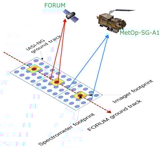
Figure 1.
Satellite ground tracks and footprints: FORUM FSI footprints (red), FEI (yellow), and IASI-NG footprints (blue) [9].
2.2. Products and Requirements
The primary product of the FORUM mission consists of the geo-located and radiometrically calibrated spectral radiances. Specifically, the FORUM Level-1 processing chain will supply calibrated radiances from 100 to 1600 cm−1, with a spectral resolution of 0.5 cm−1 or better. The radiometric noise, expressed as Noise Equivalent Spectral Radiance (NESR), is required to be less than 40 nW/(cm2 sr cm−1) in the 400–800 cm−1 interval and less than 100 nW/(cm2 sr cm−1) in the remaining FORUM range [17]. The Absolute Radiometric Accuracy (ARA) requirement is more stringent. The 3σ goal upper bounds for the ARA are set in brightness temperature and are defined as follows: <0.2 K in the range 200–300 cm−1, <0.1 K in the range 300–1100 cm−1, <0.2 K in the range 1100–1300 cm−1, and <1 K elsewhere. These specifications apply to atmospheric scene temperatures between 190 K and 300 K.
Although calibrated radiances constitute the core mission product, they will be further processed by the European Space Agency (ESA) up to Level 2. The Level-2 products will include:
- Vertical profiles of water vapor, with 2 km vertical resolution and uncertainty better than 10% in the Upper Troposphere–Lower Stratosphere (UTLS) region;
- Surface spectral emissivity in Polar regions, with an uncertainty lower than 0.01 in the FIR interval from 300 to 600 cm−1;
- Cloud parameters such as cloud top- and bottom-heights, cloud optical depth and cloud particles effective radius;
- Up-welling spectral fluxes at the top of the atmosphere.
Beyond these official products released by the ESA, additional Level-2 products are expected to be generated by the scientific processors that will be run by the individual research institutions interested in specific aspects of the atmospheric and Earth system physics. Additional scientific products may include the vertical columns of ozone, methane, nitrous oxide, nitric acid, halogenated species (e.g., CFCs), etc. HDO/H2O isotope fractionation and H2O continuum coefficients may also be retrieved from FORUM measurements as scientific products.
2.3. The FIT-FORUM Project
According to the current plans, the FORUM mission is planned for launch in late 2027; thus, to support the future exploitation of FORUM observations, research institutes have initiated dedicated preparatory activities. In this regard, in Italy, the Italian Space Agency (ASI) supported the “Forward and Inverse Tool for FORUM” (FIT-FORUM) project in the years 2023–2025. FIT-FORUM was dedicated to the development and adaptation of forward and inverse radiative transfer codes for the simulation and inversion of FORUM-like measurements. The aim was to provide accurate and versatile tools for computing spectrally resolved Earth emission under a wide range of atmospheric conditions, including clear and cloudy sky, and in the presence of aerosols. This preparatory effort has been essential for defining forward and retrieval algorithms, supporting calibration and validation activities, and maximizing the scientific return of the mission once operational [16].
3. The SIGMA Algorithm
The fast radiative transfer code SIGMA was originally designed to simulate the mid-infrared (MIR) radiances measured by IASI and was initially referred to as σ−IASI [4,14]. The code was later extended to cover the far-infrared (FIR) region, which will be probed by FORUM. Its current name, σ−IASI/F2N (Far to Near IR, see [12]) reflects the extended spectral range. The code is capable of simulating the entire OLR spectrum spanning 50–2800 cm−1, with a spectral resolution of 0.01 cm−1. The version used in this study also computes analytical Jacobians of the radiance with respect to selected atmospheric state variables and surface parameters. The speed of the code derives from an original method used to compute gas optical depths via their second-order polynomial parametrization as a function of temperature. The coefficients of the parametrization are computed offline and stored in look-up tables. The computation of the coefficients is based on a very high-spectral resolution database of gas optical depths computed with a line-by-line radiative transfer model with high accuracy, such as LBLRTM or KLIMA. In this work, we used the SIGMA forward model to simulate the spectral radiance as it would be measured by the FORUM spectrometer in nadir-viewing geometry, from a polar-orbiting platform. The forward model first produces high-resolution spectral radiances, which are then convolved with the apodized instrument response function. The FORUM spectral response was modeled with a Norton–Beer strong (NBS) function [18,19], assuming 1/(2L) = 0.3 cm−1, where L denotes the maximum optical path difference of the interferogram. The simulated spectral radiances cover the interval from 100 to 1600 cm−1, with a sampling step of 0.3 cm−1.
In cloudy-sky simulations, SIGMA represents the cloud absorption and scattering with the Chou approximation [20], as described in [13], without explicitly modifying the radiative transfer equation. It should be emphasized that the most recent version of SIGMA (version 3.0) implements Tang’s parametrization [12,21], providing significantly improved accuracy. Cloud properties, such as vertical distributions of water and ice and particle effective radius, are used to compute the extinction coefficient, single-scattering albedo and Chou coefficient, which are then supplied to the radiative transfer model. This parametrization enables SIGMA to account for cloud effects, thus permitting realistic simulations both in clear- and cloudy-sky conditions.
4. The KLIMA Algorithm
KLIMA (Kyoto Protocol-informed adaptation management) is a computationally intensive but highly accurate radiative transfer and retrieval code developed at CNR-IFAC. To date, its applications have been restricted. KLIMA has recently been described and validated in [11] through comparison with LBLRTM and monoRTM ([10]); here, we provide a brief overview. KLIMA is a stand-alone FORTRAN-based retrieval SYSTEM that includes a forward model capable of simulating atmospheric spectral radiances as observed by remote sensing instruments. It represents an evolution of the earlier MARC (Millimetre-wave Atmospheric Retrieval Code), originally developed for limb-viewing geometries in the millimeter-wave region. KLIMA now supports multiple geometrical configurations—including limb [22] zenith [23], and nadir views [3,24,25,26,27])—and an extended spectral domain ranging from the millimeter and sub-millimeter wave-bands to the near-infrared. KLIMA has also been employed to simulate nadir and limb radiances of the Martian atmosphere in internal tests related to the Planetary Fourier Spectrometer (PFS) instrument onboard the Mars Express (MEx) [28], and its results have been compared to simulations obtained using the model described in Ignatiev et al. [29]. Finally, KLIMA can perform the simultaneous inversion of two different matching observations of the same air-mass and surface pixel. This approach is usually referred to as the synergistic retrieval [16,30].
The latest and most comprehensive version of KLIMA was developed within the framework of the FIT-FORUM project, and the Earth Moon Mars (EMM) project funded by the Italian National Recovery and Resilience Plan (NRRP). As a result of these efforts, KLIMA is now used to compute high-accuracy gaseous optical depths, which are used to derive the parametrization coefficients for SIGMA, and incorporates the same cloud parameterization scheme implemented in SIGMA (EMM project). As in SIGMA, cloudy-sky simulations in KLIMA employ the Chou-based scattering approximation [20] (as described in [13]), without modifying the formal structure of the radiative transfer equation.
5. Statistical Analysis
The forward model intercomparisons presented in this work are based on 80 clear-sky atmospheric scenarios selected from a dataset of profiles derived from the outputs of the ECMWF Numerical Weather Prediction (NWP) model. These data are available through the EUMETSAT NWP Satellite Application Facility (see [31]). Each profile includes vertical distributions of temperature, H2O, CO2, O3, N2O, CO, and CH4 as function of pressure. Additional data associated with each profile include its geolocation, time of year, surface pressure and temperature, and land/sea classification. These profiles are representative of a wide range of atmospheric conditions, covering different seasons, latitudinal zones (30 polar, 27 mid-latitude, and 23 tropical profiles), and surface types (vegetation, snow, ocean, and desert). The profiles not included in this set, and still necessary for the simulation of the upwelling radiances, were extracted from the IG2 database, a climatological profile database developed for the analysis of MIPAS (Michelson Interferometer for Passive Atmospheric Sounding) measurements [32]. Surface spectral emissivity was taken from [33].
For each of these 80 clear-sky atmospheric scenarios, the FORUM spectrum was simulated. The spectral radiance emitted at the top of the Earth’s atmosphere is convolved with the instrument spectral response function. No instrumental noise or radiometric accuracy perturbations were added. These are used later in the intercomparison, as reference metrics for assessing the magnitude of the differences between radiances simulated by different forward models.
Simulations were first conducted for the above-mentioned 80 clear-sky scenarios and then repeated with the addition of either a liquid-water cloud layer or an ice-cloud layer. In terms of the cloudy scenarios, in the first case, a liquid-water cloud was inserted at 771.575 hPa, with a water content of 1 × 10⁻⁵ kg kg−1 and an effective droplet radius of 10 μm. In the second case, an ice cloud was introduced at 262.441 hPa, with the same ice content and an effective crystal radius of 30 μm. Cloud altitudes and microphysical properties were based on [13]. In both ice- and water-cloud cases, a full cloud cover in the instrument field of view (cloud fraction = 1) was assumed.
Figure 2 shows, as an example, the radiances calculated for a single atmospheric scenario, in clear-sky conditions, and when a water or an ice cloud is introduced. In Figure 3 the differences between the cloudy- and the clear-sky radiances are shown. The impact of ice and water clouds is significant and strongly affects the radiance at the top of the atmosphere. The effect of the ice cloud, as expected, is also very relevant in the far-infrared region. Note also that, as expected, the CO2 absorption from approximately 620 to 720 cm−1 is not affected by clouds. This is because in this region, the strong CO2 absorption renders the atmosphere optically thick, and the radiance is sensitive only to the state of the stratosphere. The impact of clouds on TOA spectral radiance is substantial; it is very important to be able to distinguish radiance signals originating from different weather conditions. The negative differences between cloudy- and clear-sky radiances indicate that the radiance is higher in the absence of clouds, which implies that clouds enhance the greenhouse effect by absorbing and re-emitting thermal radiation, thereby contributing to the greenhouse effect.
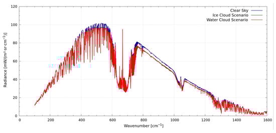
Figure 2.
Radiances simulated in clear sky (blue) and by adding an ice (red) or a water (green) cloud.
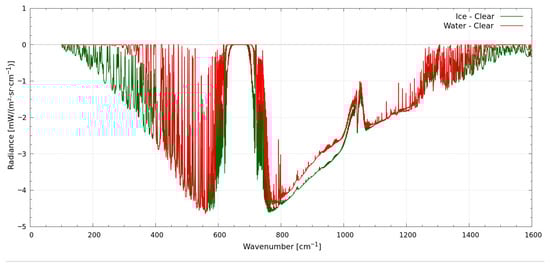
Figure 3.
Cloudy- minus clear-radiance differences.
First, we repeated the same comparison between SIGMA and KLIMA codes made by Ridolfi [15], on the basis of clear-sky atmospheric scenarios. As explained in [15], the statistical properties of the differences between SIGMA and KLIMA radiances computed for each clear-sky scenario were evaluated. At each spectral channel, we compute the average value of the differences (AVG), their Root Mean Square (RMS), their standard deviation (STD), and maximum absolute difference (MAX).
Each of these quantifiers characterizes a specific aspect of the differences between the computed radiances. More specifically:
AVG represents the channel-by-channel average of the SIGMA–KLIMA differences along the spectrum, highlighting any systematic bias.
STD is the standard deviation of the differences, quantifying the dispersion of the differences about their average value.
RMS (Root Mean Square error) is the square root of the mean of the squared differences. It accounts for both bias and variability and is commonly used as a quantifier of the total error.
MAX indicates the maximum absolute value of the difference between SIGMA and KLIMA at each spectral channel, showing the largest error observed across the 80 scenarios.
The random differences (i.e., the differences that change randomly from one scenario to another) are quantified by the STD. Two radiative transfer models may be considered equivalent for the analysis of FORUM individual measurements if the STD of the simulated radiance differences is smaller than the expected measurement NESR. Conversely, in applications involving the averaging of large sets of residuals of the fit (observed minus simulated radiances) are computed with the aim of identifying systematic errors, such as the errors that may originate from spectroscopic line parameter inaccuracies, the error due to forward model optimizations should be smaller than the measurement ARA. Thus, for this type of application, the average difference (AVG) should be smaller than the ARA.
6. Discussion
Figure 4 compares the various statistical quantifiers of the SIGMA–KLIMA radiance differences to the FORUM NESR (gold) and ARA (cyan) requirements. In summary, the random component of the model differences is clearly smaller than the FORUM NESR requirement; thus, the two forward models can be considered equivalent when processing the individual measurements. Nevertheless, the AVG differences are not smaller than the required FORUM ARA, suggesting that limitations in the SIGMA parameterization may introduce a significant bias whenever applications require averaging of large sets of residuals.
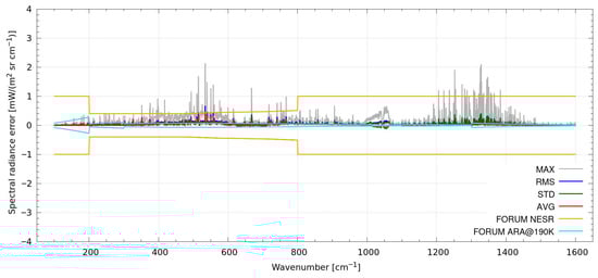
Figure 4.
Statistics of the differences SIGMA –KLIMA on the 80 clear-sky scenarios. The various statistical estimators (see plot’s key) are compared to the FORUM NESR (gold) and ARA (cyan) specifications.
After the clear-sky analysis, we extended the simulations by introducing the water and ice clouds as explained above. Ideally, the agreement between the two sets of simulations made with KLIMA and SIGMA should not degrade significantly.
We modified the 80 original clear-sky scenarios by inserting water clouds and ice clouds and calculated their respective radiances with both the KLIMA and SIGMA programs. To each scenario, we first added a water cloud in the layer with an effective pressure of ≈771 hPa. The water cloud consists of a liquid-water concentration equal to 1.1 × 10⁻⁵ kg kg−1, with an effective droplet radius of 10 μm. Note that the addition of such a cloud layer is possible for only 71 out of the 80 selected scenarios, where the 771 hPa layer (≈2200 m a.s.l.) is located above the surface, which is not always the case in the presence of high mountains. We then calculated the radiances corresponding to the modified scenarios both with KLIMA and SIGMA. We then repeated the same procedure by inserting in the original 80 clear-sky scenarios an ice cloud in the layer with effective pressure of ≈262 hPa, with an ice concentration of 1.1 × 10⁻⁵ kg/kg with crystal effective radius of 30 μm. We then computed the corresponding radiances with both KLIMA and SIGMA. Finally, we compared KLIMA and SIGMA results with a statistical analysis similar to that carried out for the clear-sky case. The results are reported in Figure 5a,b below, where the key “liquid-water cloud scenarios”/“ice-cloud scenarios” indicates the scenarios with a water cloud, while the key “ice-sky scenarios” indicates the scenarios with an ice cloud.
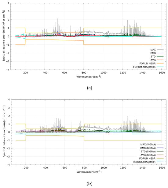
Figure 5.
Statistics of the SIGMA-KLIMA differences in cloudy- sky scenarios. (a) Statistics of the SIGMA–KLIMA differences in the 80 liquid-water cloud sky scenarios. The various statistical estimators (see plot key) are compared to the FORUM NESR. (b) Statistics of the SIGMA–KLIMA differences in the 80 ice-cloud sky scenarios. The various statistical estimators (see plot key) are compared to the FORUM NESR.
From the results we can see that the SIGMA-KLIMA agreement demonstrated in the clear case is also confirmed in the cloudy case, despite some differences being present.
The SIGMA-KLIMA differences in the cloudy case differ from those in clear sky due to the different length of the optical path in the atmospheric layers used by the two codes: while SIGMA assumes the layer’s geometrical thickness of a reference atmospheric model, KLIMA exploits the hydrostatic equilibrium to compute this quantity. If we force the KLIMA code to use the same path-length of SIGMA, the differences between the simulated radiances in cloudy sky become very similar to those observed in the clear case, as Figure 6a,b clearly demonstrate.
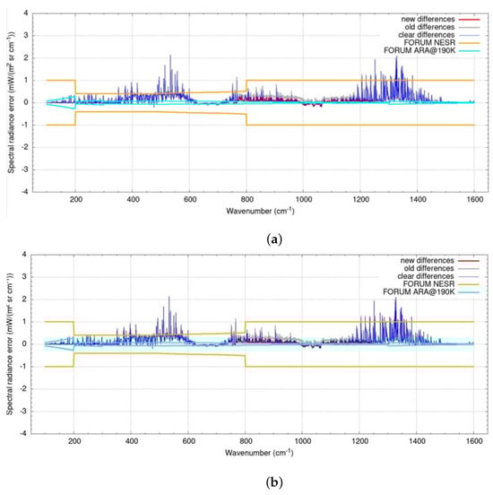
Figure 6.
Statistics of the SIGMA-KLIMA differences in cloudy-sky scenarios where KLIMA uses the same path length as SIGMA. (a) Statistics of the SIGMA–KLIMA differences in the 80 water-cloud scenarios, where KLIMA was forced to use the same path length as SIGMA. The various statistical estimators (see plot key) are compared to the FORUM NESR and ARA. (b) Statistics of the SIGMA–KLIMA differences in the 80 ice-cloud scenarios, where KLIMA was forced to use the same path length as SIGMA. The various statistical estimators (see plot key) are compared to the FORUM NESR and ARA.
Finally, we compared the results of the two considered RTMs even in the presence of a “mixed” cloud, i.e., in the presence of both an ice and a water cloud. To do this we modified the 80 starting scenarios with clear skies by inserting two types of clouds in each scenario: a water cloud with the same characteristics used in the “water-cloud sky” case at the pressure level 771.576 hPa and an ice cloud with the same characteristics as that used in the “ice-cloud sky” case at the pressure level 262.441 hPa. The results are shown in Figure 7, where “mix-cloud sky scenario” means scenarios where water and ice clouds are both present.
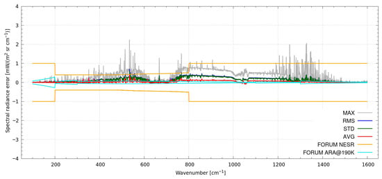
Figure 7.
Statistics of the SIGMA–KLIMA differences in the 80 mix-cloud sky scenarios. The various statistical estimators (see plot key) are compared to the FORUM NESR.
As we can see, the agreement between the SIGMA and KLIMA codes demonstrated in the clear-sky case is confirmed also in the cloudy-sky case. This seems to demonstrate that KLIMA has the potential to simulate spectra in all atmospheric conditions, although with a different precision in reference to the spectral lines—obtained through a line-by-line code and model—and to the cloud effect—obtained thanks to the Chou approximation of the scatterin g. Indeed, the Chou model currently used to represent cloud scattering is an approximation. It simplifies the radiative transfer by treating cloud optical properties in a way that neglects some of the complexities of multiple scattering and phase function variability. In the near future, SIGMA will also include the Tang correction, providing a more accurate description of scattering processes by incorporating a more realistic representation of cloud microphysics and angular scattering effects [13,34].
Although the Chou approximation is certainly limited in accuracy, especially in the FIR region, it allows KLIMA to be a simulator of a wide range of atmospheric spectra. Therefore, now it can be used for the simulation of measured spectra, thus helping to improve our understanding of the Earth’s atmosphere.
7. Application to Real Data
7.1. HEMERA3 Field Campaign on Stratospheric Balloon
In preparation for the FORUM mission, in August 2022 a stratospheric balloon measurement field campaign called HEMERA3 took place in Timmins, Canada [35]. During this campaign, the Far-Infrared Radiation Mobile Observation System–Balloon version (FIRMOS-B) was placed, together with other instruments, onboard the gondola (named CARMEN), and provided measurements of the Earth’s emitted spectral radiance in the 100–1000 cm−1 band during a flight lasting about 15 h and 10 min. The spectral range observed by FIRMOS-B covers an important portion—including the far-infrared (FIR) below 650 cm−1—of the spectral band that will be measured by FORUM.
The balloon was launched at 18:00 UTC on 23 August, reached a maximum altitude of 36 km in the stratosphere at 20:00 UTC, and landed at 09:15 UTC on 24 August, after covering a maximum ground distance of 150 km. FIRMOS measurements were divided into seven main sequences: the first two (named f1s002 and f1s007) between 18:36 and 19:53 UTC under clear-sky conditions, and the last five (named f2s002, f2s010, f2s011, f2s012, and f2s013) between 20:46 and 23:34 UTC in the presence of different types of clouds. Each sequence consisted of 34 calibrated nadir radiance spectra.
The cloud presence within the instrument’s field of view was monitored using a visible camera installed on board. Images under clear-sky conditions show both the variability of the surface observed from the gondola during the first two sequences, and the occurrence of thick liquid-water clouds, as well as thinner overlying clouds whose composition can likely be attributed to ice.
The availability of cloudy measurements, with different cloud types, enabled us to test the capability of KLIMA to simulate the top-of-atmosphere cloudy-sky radiances, by exploiting the cloud parameters retrieved with a different code, named SACR, the Simultaneous Atmospheric and Cloud Retrieval code. Prior to the discussion of the test setup and results, in the next Section, we briefly summarize the features of the SACR code developed at CNR-INO.
7.2. Simultaneous Atmospheric and Cloud Retrieval (SACR) Code
SACR [36] is a retrieval code based on an optimal estimation approach, using a priori information, and the iterative Levenberg–Marquardt formula. The retrieval algorithm calls a forward model that integrates the well-known line-by-line radiative transfer model (LBLRTM), which simulates the spectral behavior of the optical depths of molecular species, together with a validated in-house radiative transfer module based on the two-stream δ-Eddington approximation, capable of simulating aerosol particle scattering in the atmosphere.
Specifically, the code can ingest single-scattering property databases provided for water droplets and ice crystals of various habits [37,38] to simulate the scattering, emission and absorption contributions of water, mixed-phase, and ice clouds such as high-altitude cirrus.
The retrieval algorithm can derive, from spectral radiance measurements at different zenith angles, the bulk optical and microphysical cloud properties such as the total optical depth, the effective radius of water droplets and ice crystals, and the ice fraction. Additionally, if needed, it can simultaneously retrieve cloud top and bottom heights, atmospheric profiles of water vapor and temperature, ozone total column, and surface temperature.
Beyond these parameters, SACR also allows for the retrieval of frequency stretch for frequency calibration and the mixing coefficient of the sinc and sinc2 components of the instrument function. Recently, it has also been extended to allow for the retrieval of the habit distribution of ice crystals [39].
Over the past years, SACR has been successfully applied to the comprehensive analysis of atmospheric radiance measurements detected from the ground by the Radiation Explorer Far InfraRed—Prototype for Application and Development (REFIR-PAD) Fourier Transform Spectrometer in Antarctica at Dome-C and Testa Grigia (Italian Alps), from FIRMOS (Far Infra-Red Mobile ObServatory) first prototype and the Far-INfrarEd Spectrometer for Surface Emissivity (FINESSE) spectrometers at ground-based stations in Zugspitze (Germany) and Andoya (Norway), and finally from balloon-borne REFIR-PAD measurements from Teresina (Brazil) and, as already discussed, from Timmins (Canada) during the HEMERA3 campaign. Finally, it has proven effective in inverting synthetic observations simulating future FORUM measurements.
7.3. Verification Test
To verify the performance of the cloud model newly implemented in KLIMA, we proceeded as follows. We selected a cloudy measurement acquired by FIRMOS-B in the HEMERA campaign. The selected spectrum was number #1661296264 of sequence f2s011. From this measurement, SACR retrieves the largest cloud optical depth [35].
From this measurement, we first retrieved the temperature and water vapor profiles using KLIMA, with the cloud model disabled. Then, we repeated the KLIMA retrieval with the cloud model enabled, and assuming the cloud parameters retrieved by SACR from the same measurement. Then, we compared the temperature and water vapor profiles retrieved by KLIMA in the two approaches, with the analogous profiles retrieved by SACR.
For this test, the KLIMA retrieval setup was made as similar as possible to that of the SACR code: we used the same retrieval grid and a priori state estimates and errors. When we enabled the cloud model, we defined the cloud vertical extension from 3 to 6 km, we set the particles’ effective radius to 15.8 and 26.5 micron for liquid and ice particles, respectively, and the concentrations equal to 7.36 × 10⁻⁶ and 9.94 × 10⁻⁶ kg kg−1 for liquid and ice particles, respectively. These are the values retrieved by the SACR code and converted to the KLIMA input, as indicated in [35].
Figure 8 and Figure 9 show the differences between the KLIMA- and SACR-retrieved profiles of H2O and temperature, respectively. In these figures, the red lines refer to KLIMA without including the cloud model, while the green lines refer to KLIMA including the cloud model. Black lines indicate the ±1σ bounds of the SACR error. The cloud top height is marked by a horizontal orange line. We clearly see that in both H2O and temperature cases, the KLIMA-retrieved profile is closer to the SACR profile when the cloud model of KLIMA is enabled. When the KLIMA cloud model is enabled, the retrieved KLIMA and SACR profiles become compatible within the retrieval-error bounds.
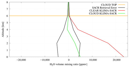
Figure 8.
Differences between KLIMA- and SACR-retrieved H2O profiles. The red curves correspond to KLIMA with the cloud model disabled, whereas the green curves correspond to KLIMA including the cloud model. Black lines indicate the SACR error. The cloud top height is marked by the orange line.
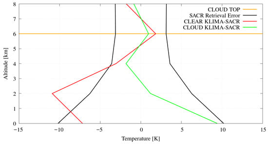
Figure 9.
Differences between KLIMA- and SACR-retrieved temperature profiles. The red line refers to KLIMA with the cloud model disabled, the green line to KLIMA including the cloud model. Black lines indicate the SACR error. The cloud top height is marked by the orange line.
8. Conclusions
With the increasing number of space missions dedicated to the observation of the Earth’s emission spectra, the availability of a reliable and computationally efficient radiative transfer model capable of representing the Earth’s atmosphere under a wide range of conditions has become essential. In this study, we have demonstrated that KLIMA successfully combines the accuracy of line-by-line radiative transfer models with the computational efficiency of the approximate cloud parametrization adopted in the fast forward model SIGMA version 2.4.
To assess its performance, we simulated the radiance reaching the FORUM satellite instrument for 80 clear-sky atmospheric scenarios, derived from a dataset of ECMWF NWP profiles and representative of a wide range of atmospheric conditions, including different seasons, latitudes, and surface types.
First, we reproduced the comparison between the FORUM measurement simulations obtained using KLIMA and SIGMA in clear sky conditions, as previously done by Ridolfi [15]. We then extended the analysis to cloudy-sky conditions, where cloud simulations within KLIMA were performed using the same parametrization implemented in version 2.4 of the SIGMA code [12,13].
The excellent agreement between the outputs of SIGMA and KLIMA—even under cloudy conditions, particularly when using consistent path length values—demonstrates that KLIMA can effectively simulate cloudy atmospheres, with accuracy levels that depend on factors such as emission features and cloud properties. These differences stem from the different modeling strategies adopted by the two codes to represent the underlying physical processes.
On this basis, this hybrid approach enables radiative simulations that are both accurate under clear-sky conditions and computationally efficient in the presence of clouds, making the model well-suited for large-scale applications. The integration of advanced physical modules with a flexible cloud representation framework allows KLIMA to reproduce observed spectra across a wide range of atmospheric scenarios. Such capabilities are particularly relevant for the characterization of the Upper Troposphere—Lower Stratosphere region and its role in the radiative budget, as demonstrated in recent synergistic limb–nadir studies (e.g., [16]).
The good consistency between KLIMA, SIGMA, and observational data further validates the proposed approach and confirms KLIMA as a robust tool for applications requiring detailed radiative transfer modeling across a wide range of atmospheric conditions.
As shown in Section 7, these results highlight the potential and broad applicability of KLIMA in atmospheric studies where both accuracy and computational efficiency are essential. In addition, the model performance under all-sky conditions, in both clear and cloudy atmospheres, has been validated using real measurements from the HEMERA3 stratospheric balloon campaign. In this context, the cloud optical and microphysical properties retrieved by the SACR (Simultaneous Atmospheric and Cloud Retrieval) algorithm were used to assess the ability of KLIMA to correctly simulate top-of-atmosphere radiances in the presence of clouds.
Author Contributions
Conceptualization, M.R., S.D.B. and U.C.; methodology, S.D.B. and E.B.; software, S.D.B., G.D.N. and E.B.; validation, E.B., S.D.B., G.D.N.; formal analysis, S.D.B., E.B. and M.R.; investigation, E.B.; data curation, S.D.B. and M.R.; writing—original draft preparation, E.B. and S.D.B.; writing—review and editing, U.C. and M.R.; supervision, M.R., S.D.B. and U.C.; project administration, U.C.; model integration and cloud parametrization adaptation, E.B. and S.D.B.; scientific framework and inter-model comparison, S.D.B. and M.R. All authors have read and agreed to the published version of the manuscript.
Funding
This research was funded by the Italian Space Agency (ASI), FIT-FORUM project. Part of the research activities described in this paper were carried out with the contribution of the Next Generation EU funds within the National Recovery and Resilience Plan (PNRR), Mission 4—Education and Research, Component 2—From Research to Business (M4C2), Investment Line 3.1—Strengthening and creation of Research Infrastructures, Project IR0000038–“Earth Moon Mars (EMM)”. EMM is led by INAF in partnership with ASI and CNR. The EMM research activities described in this paper were coordinated and executed by CNR.
Informed Consent Statement
Not applicable.
Data Availability Statement
The atmospheric profile data used in this study are publicly available from the EUMESTAT NWP SAF database: https://www.nwpsaf.eu/site/software/atmospheric-profile-data/ (accessed on 11 January 2026).
Acknowledgments
The authors would like to thank University of Basilicata and University of Bologna for providing the SIGMA model, as well as the new parametrization approach contained within the model, and for supporting us. In addition, the authors would like to thank the FIT-FORUM and EMM projects teams.
Conflicts of Interest
The authors declare no conflicts of interest.
References
- Rodgers, C.D. Inverse Methods for Atmospheric Sounding: Theory and Practice; Series on Atmospheric, Oceanic and Planetary Physics; World Scientific Publishing Co. Pte. Ltd.: Singapore, 2000; Volume 2. [Google Scholar]
- Liou, K.N. An Introduction to Atmospheric Radiation, 2nd ed.; International Geophysics Series; Academic Press: San Diego, CA, USA, 2002; Volume 84. [Google Scholar]
- Ceccherini, S.; Cortesi, U.; Del Bianco, S.; Raspollini, P.; Carli, B. IASI-METOP and MIPAS-ENVISAT data fusion. Atmos. Chem. Phys. 2010, 10, 4689–4698. [Google Scholar] [CrossRef]
- Liuzzi, G.; Masiello, G.; Serio, C.; Venafra, S.; Camy-Peyret, C. Physical inversion of the full IASI spectra: Assessment of atmospheric parameters retrievals, consistency of spectroscopy and forward modelling. J. Quant. Spectrosc. Radiat. Transf. 2016, 182, 128–157. [Google Scholar] [CrossRef]
- Carli, B.a.; Mencaraglia, F.; Dinelli, B.; Piccioli, S.; Valboni, A. Comparison of measured and calculated high-resolution spectra of far-infra-red stratospheric emission. Il Nuovo Cimento C 1985, 8, 631–646. [Google Scholar] [CrossRef]
- Pachot, C.; Dominguez, B.C.; Oetjen, H.; Sierk, B.; Mariani, F.; Riel, S.; Rodrigues, G.; Copano, M.; Carou, A.M.; Palchetti, L.; et al. The infrared Fourier transform spectrometer and the infrared imager instrument concepts for the FORUM mission, ESA’s 9th Earth Explorer. In Sensors, Systems, and Next-Generation Satellites XXIV; SPIE: Bellingham, WA, USA, 2020; Volume 11530, pp. 31–47. [Google Scholar]
- Turner, E.C.; Lee, H.T.; Tett, S.F. Using IASI to simulate the total spectrum of outgoing long-wave radiances. Atmos. Chem. Phys. 2015, 15, 6561–6575. [Google Scholar] [CrossRef]
- Dong, Y.; Proistosescu, C.; Armour, K.; Battisti, D. Attributing historical and future evolution of radiative feedbacks to regional warming patterns using a Green’s function approach: The preeminence of the western Pacific. J. Clim. 2019, 32, 5471–5491. [Google Scholar] [CrossRef]
- Palchetti, L.; Brindley, H.; Bantges, R.; Buehler, S.; Camy-Peyret, C.; Carli, B.; Cortesi, U.; Del Bianco, S.; Di Natale, G.; Dinelli, B.M.; et al. Unique far-infrared satellite observations to better understand how Earth radiates energy to space. Bull. Am. Meteorol. Soc. 2020, 101, E2030–E2046. [Google Scholar] [CrossRef]
- Clough, S.; Shephard, M.; Mlawer, E.; Delamere, J.; Iacono, M.; Cady-Pereira, K.; Boukabara, S.; Brown, P. Atmospheric radiative transfer modeling: A summary of the AER codes. J. Quant. Spectrosc. Radiat. Transf. 2005, 91, 233–244. [Google Scholar] [CrossRef]
- Dinelli, B.; Del Bianco, S.; Castelli, E.; Di Roma, A.; Lorenzi, G.; Premuda, M.; Barbara, F.; Gai, M.; Raspollini, P.; Di Natale, G. GBB-Nadir and KLIMA: Two Full Physics Codes for the Computation of the Infrared Spectrum of the Planetary Radiation Escaping to Space. Remote Sens. 2023, 15, 2532. [Google Scholar] [CrossRef]
- Masiello, G.; Serio, C.; Maestri, T.; Martinazzo, M.; Masin, F.; Liuzzi, G.; Venafra, S. The new σ-IASI code for all sky radiative transfer calculations in the spectral range 10 to 2760 cm−1: σ-IASI/F2N. J. Quant. Spectrosc. Radiat. Transf. 2024, 312, 108814. [Google Scholar] [CrossRef]
- Martinazzo, M.; Magurno, D.; Cossich, W.; Serio, C.; Masiello, G.; Maestri, T. Assessment of the accuracy of scaling methods for radiance simulations at far and mid infrared wavelengths. J. Quant. Spectrosc. Radiat. Transf. 2021, 271, 107739. [Google Scholar] [CrossRef]
- Amato, U.; Masiello, G.; Serio, C.; Viggiano, M. The σ-IASI code for the calculation of infrared atmospheric radiance and its derivatives. Environ. Model. Softw. 2002, 17, 651–667. [Google Scholar] [CrossRef]
- Del Bianco Ridolfi, C. DOC:EMM-CNR-EMN01-RP-0001, ISSUE:1. EMM Rev. Fast Radiat. Transf. Model. 2023, 1, 23. [Google Scholar]
- Ridolfi, M.; Tirelli, C.; Ceccherini, S.; Belotti, C.; Cortesi, U.; Palchetti, L. Synergistic Retrieval and Complete Data Fusion Methods Applied to Simulated FORUM and IASI-NG Measurements. Atmos. Meas. Tech. 2022, 15, 6723–6737. [Google Scholar] [CrossRef]
- Oetjen, H. Report for Mission Selection: FORUM; Technical Report ESA-EOPSM-FORM-RP-3549; European Space Agency (ESA): Noordwijk, The Netherlands, 2019. [Google Scholar]
- Norton, R.H.; Beer, R. New apodizing functions for Fourier spectrometry. J. Opt. Soc. Am. 1976, 66, 259–264, Erratum in J. Opt. Soc. Am. 1977, 67, 419. https://doi.org/10.1364/JOSA.67.000419. [Google Scholar] [CrossRef]
- Naylor, D.A.; Tahic, M.K. Apodizing functions for Fourier transform spectroscopy. J. Opt. Soc. Am. A 2007, 24, 3644–3648. [Google Scholar] [CrossRef] [PubMed]
- Chou, M.D.; Lee, K.T.; Tsay, S.C.; Fu, Q. Parameterization for cloud longwave scattering for use in atmospheric models. J. Clim. 1999, 12, 159–169. [Google Scholar] [CrossRef]
- Tang, G.; Yang, P.; Kattawar, G.W.; Huang, X.; Mlawer, E.J.; Baum, B.A.; King, M.D. Improvement of the simulation of cloud longwave scattering in broadband radiative transfer models. J. Atmos. Sci. 2018, 75, 2217–2233. [Google Scholar] [CrossRef]
- Del Bianco, S.; Carli, B.; Cecchi-Pestellini, C.; Dinelli, B.M.; Gai, M.; Santurri, L. Retrieval of minor constituents in a cloudy atmosphere with remote-sensing millimetre-wave measurements. Q. J. R. Meteorol. Soc. 2007, 133, 163–170. [Google Scholar] [CrossRef]
- Belotti, C.; Barbara, F.; Barucci, M.; Bianchini, G.; D’Amato, F.; Del Bianco, S.; Di Natale, G.; Gai, M.; Montori, A.; Pratesi, F.; et al. The Far-Infrared Radiation Mobile Observation System for spectral characterisation of the atmospheric emission. EGUsphere 2022, 2022, 2511–2529. [Google Scholar] [CrossRef]
- Bianchini, G.; Carli, B.; Cortesi, U.; Del Bianco, S.; Gai, M.; Palchetti, L. Test of far-infrared atmospheric spectroscopy using wide-band balloon-borne measurements of the upwelling radiance. J. Quant. Spectrosc. Radiat. Transf. 2008, 109, 1030–1042. [Google Scholar] [CrossRef]
- Del Bianco, S.; Carli, B.; Gai, M.; Laurenza, L.M.; Cortesi, U. XCO2 retrieved from IASI using KLIMA algorithm. Ann. Geophys. 2013, 56, S0336. [Google Scholar] [CrossRef]
- Tirelli, C.; Ceccherini, S.; Zoppetti, N.; Del Bianco, S.; Cortesi, U. Generalization of the complete data fusion to multi-target retrieval of atmospheric parameters and application to FORUM and IASI-NG simulated measurements. J. Quant. Spectrosc. Radiat. Transf. 2021, 276, 107925. [Google Scholar] [CrossRef]
- Sgheri, L.; Belotti, C.; Ben-Yami, M.; Bianchini, G.; Carnicero Dominguez, B.; Cortesi, U.; Cossich, W.; Del Bianco, S.; Di Natale, G.; Guardabrazo, T.; et al. The FORUM end-to-end simulator project: Architecture and results. Atmos. Meas. Tech. 2022, 15, 573–604. [Google Scholar] [CrossRef]
- Formisano, V.; Angrilli, F.; Arnold, G.; Atreya, S.; Bianchini, G.; Biondi, D.; Blanco, A.; Blecka, M.; Coradini, A.; Colangeli, L.; et al. The Planetary Fourier Spectrometer (PFS) onboard the European Mars Express mission. Planet. Space Sci. 2005, 53, 963–974. [Google Scholar] [CrossRef]
- Ignatiev, N.; Grassi, D.; Zasova, L. Planetary Fourier spectrometer data analysis: Fast radiative transfer models. Planet. Space Sci. 2005, 53, 1035–1042. [Google Scholar] [CrossRef]
- Caligiuri, C.; Barbara, F.; Barucci, M.; Belotti, C.; Bianchini, G.; Cortesi, U.; D’Amato, F.; Della Fera, S.; Del Bianco, S.; Dinelli, B.M.; et al. Poster: Feasibility Study of HDO Retrieval from FORUM-EE9 Measurements. In Living Planet Symposium 2022; ESA: Bonn, Germany, 2022. [Google Scholar]
- NWPSAF Atmospheric Profile Data. Available online: www.nwpsaf.eu/site/software/atmospheric-profile-data/ (accessed on 11 January 2026).
- Remedios, J.J.; Leigh, R.J.; Waterfall, A.M.; Moore, D.P.; Sembhi, H.; Parkes, I.; Greenhough, J.; Chipperfield, M.P.; Hauglustaine, D. MIPAS reference atmospheres and comparisons to V4.61/V4.62 MIPAS level 2 geophysical data sets. Atmos. Chem. Phys. Discuss. 2007, 7, 9973–10017. [Google Scholar] [CrossRef]
- Huang, X.; Chen, X.; Zhou, D.K.; Liu, X. An Observationally Based Global Band-by-Band Surface Emissivity Dataset for Climate and Weather Simulations. J. Atmos. Sci. 2016, 73, 3541–3555. [Google Scholar] [CrossRef]
- Serio, C.; Masiello, G.; Liuzzi, G.; Cersosimo, A.; Maestri, T.; Martinazzo, M.; Masin, F.; Pelliccia, G.P.; Venafra, S.; Camy-Peyret, C. Demonstration of a physical inversion scheme for all-sky, day-night IASI observations and application to the analysis of the onset of the Antarctica ozone hole: Assessment of retrievals and consistency of forward modeling. J. Quant. Spectrosc. Radiat. Transf. 2024, 329, 109211. [Google Scholar] [CrossRef]
- Di Natale, G.; Belotti, C.; Barucci, M.; Ridolfi, M.; Viciani, S.; D’Amato, F.; Del Bianco, S.; Maria Dinelli, B.; Palchetti, L. Retrieval of Cloud, Atmospheric, and Surface Properties from Far-Infrared Spectral Radiances Measured by FIRMOS-B During the 2022 HEMERA Stratospheric Balloon Campaign. Remote Sens. 2025, 17, 2458. [Google Scholar] [CrossRef]
- Di Natale, G.; Palchetti, L.; Bianchini, G.; Ridolfi, M. The two-stream δ-Eddington approximation to simulate the far infrared Earth spectrum for the simultaneous atmospheric and cloud retrieval. J. Quant. Spectrosc. Radiat. Transf. 2020, 246, 106927. [Google Scholar] [CrossRef]
- Yang, P.; Bi, L.; Baum, B.A.; Liou, K.N.; Kattawar, G.W.; Mishchenko, M.I.; Cole, B. Spectrally Consistent Scattering, Absorption, and Polarization Properties of Atmospheric Ice Crystals at Wavelengths from 0.2 to 100 μm. J. Atmos. Sci. 2013, 70, 330–347. [Google Scholar] [CrossRef]
- Bi, L.; Yang, P. Accurate simulation of the optical properties of atmospheric ice crystals with the invariant imbedding T-matrix method. J. Quant. Spectrosc. Radiat. Transf. 2014, 138, 17–35. [Google Scholar] [CrossRef]
- Di Natale, G.; Ridolfi, M.; Palchetti, L. A new approach to crystal habit retrieval from far-infrared spectral radiance measurements. Atmos. Meas. Tech. 2024, 17, 3171–3186. [Google Scholar] [CrossRef]


Disclaimer/Publisher’s Note: The statements, opinions and data contained in all publications are solely those of the individual author(s) and contributor(s) and not of MDPI and/or the editor(s). MDPI and/or the editor(s) disclaim responsibility for any injury to people or property resulting from any ideas, methods, instructions or products referred to in the content. |
© 2026 by the authors. Licensee MDPI, Basel, Switzerland. This article is an open access article distributed under the terms and conditions of the Creative Commons Attribution (CC BY) license.