Highlights
What are the main findings?
- Inadequate calibration of visible cameras can induce significant effects on our estimates of column height or the position of ballistic products and, therefore, on any derived volcanological parameter.
- PhixCam is a user-friendly program that allows volcanologists to georeference in the 3D space the position of objects tracked in visible camera frames, when a given transport plane is assumed.
What is the implication of the main findings?
- We have shown the operative potential of Phixcam, which provides data to volcano observatories that can be used to interpret the height of volcanic products when they are dispersed in specific directions, as well as the associated uncertainty.
- This program can be adopted to analyze historical pictures of volcanic events and estimate their eruption source parameters.
Abstract
Visible cameras are widely adopted low-cost instruments for volcano monitoring. Images can be used to characterize volcanic activity of variable intensity and style and to estimate key eruption source parameters that are essential for assessing volcanic hazards. Nevertheless, the analysis of images from visible cameras is subject to significant sources of uncertainty and operational limitations. In addition to visibility issues caused by meteorological phenomena and variable illumination, assigning the pixel position of an object of interest (e.g., volcanic plumes, ballistic projectiles) to a specific geographic location and elevation is not straightforward, introducing substantial uncertainty in the estimation of eruption parameters. We present PhixCam, a Python tool that allows the user to georeference in the 3D space the visual field of surveillance cameras from minimal input data: a DEM, the camera position, and a reference image where the framed relief can be outlined. The software includes functions to construct conversion matrices that can be adopted to translate the position of pixels into elevation above sea level when different emission directions of volcanic products are considered, thereby allowing users to assess the confidence of the results. This code was tested on a series of cameras of the Chilean Volcanic Surveillance Network, showing its operative potential in volcanic observatories, and on historical pictures, allowing us to estimate data of interest in volcanology for poorly monitored volcanic events.
1. Introduction
Visible cameras are an essential part of any network of volcano monitoring around the world [1,2,3,4,5,6]. They are fundamental tools to characterize volcanic activity and interpret geophysical signals in terms of surface processes [2,7,8]. Visible cameras can also be adopted to estimate crucial parameters of explosive volcanism [9,10], such as column height and launch conditions of ballistic projectiles [6,11], of great relevance to inform numerical models of different volcanic processes and to improve hazard assessments [12,13,14,15,16], complementing the information derived from the increasing number of remote sensing techniques that are routinely applied in monitoring of volcanic and other natural systems [17,18,19,20,21,22]. In addition, they have been coupled with thermal cameras to quantitatively describe volcanic explosions [23] and have also been proven to be useful for tracking the advance of lava flows [8].
However, despite their apparent simplicity, the analysis of images from visible cameras is subject to multiple sources of uncertainty [2,9,10,11,24]. For instance, the frequent lack of knowledge about the direction towards which volcanic products are emitted during an eruption introduces substantial uncertainty in computing the actual position of an object tracked in the atmosphere (e.g., ballistic bombs or a volcanic plume) when projected on a 2D image. Moreover, the exact orientation of surveillance cameras is often unclear and subjected to changes in time due to different meteorological phenomena or during maintenance operations that cannot be correctly performed in remotely way. Moreover, the installation site of these cameras is by itself strongly conditioned by the feasibility of data transmission, power supply or access. As a consequence, volcanic surveillance visible cameras are frequently unleveled, with significant effects on any derived estimation of volcanological parameters.
Some authors have addressed the problem of volcanic surveillance camera calibration and the assignment of a position in the space to the different pixels that make up the frames [9,10,24]. Scollo et al. [9] calibrated the ECV camera of Etna volcano based on the analysis of a series of captures framing a chessboard pattern with different orientations, and considering geographically known features [25,26]. Ospina et al. [24] presented a field calibration methodology of visible cameras and applied it to a series of Colombian monitoring instruments. Barnie et al. [10] compared the performance of camera calibrations based on chessboard patterns, the position of stars, and terrain features, which include horizon matching, for the analysis of the 2021 Fagradalsfjall eruption, in Iceland. Despite these recent efforts, open-source computational tools to assist volcanologists in all the stages of this process in a standardized and reproducible manner are not available in the literature, and the use of equidistant horizontal isolines to compute plume height is still frequent in volcano observatories. All these conditions create the need to develop a reproducible procedure to georeference (or calibrate) the images captured by visible cameras that is simple and fast enough to allow for the calibration of the high number of cameras that volcano observatories usually manage, with highly variable characteristics in terms of star visibility at night, characteristic topographic features and topography irregularity. In this paper, we present a user-friendly, open-source and freely-downloadable Python-based tool that allows the user to delimit, using a reproducible approach, the visual field of visible cameras with minimal input information: a DEM, the camera position and a reference image where the framed relief can be outlined. From this, the code permits to estimate the position in the space associated with each pixel of the captured images when different emission directions of volcanic products are considered. This code was tested on a series of cameras of the Red Nacional de Vigilancia Volcánica (National Volcanic Surveillance Network) in Chile, managed by Sernageomin (National Service of Geology and Mining), showing its operative potential in volcanic observatories to improve our quantification, standardization and interpretation capacity of the information provided by visible cameras and its uncertainty. In this work, we also show the application of this tool to analyze historical pictures of volcanic eruptions, taking as an illustrative example a photo of the 1961 eruption of Calbuco volcano, in Chile.
2. Methods
2.1. Visible Cameras and Topography Data
The Chilean volcano monitoring network, managed by Sernageomin, involves 43 active volcanoes distributed along more than . Most of them are part of the Central and Southern Volcanic Zones of the Andes [27,28]. The erupted products range in composition from basaltic to rhyolitic, with a wide variety of eruption styles [29]. The instrumentation of this volcano monitoring network includes geophysical ground-based sensors (seismicity, deformation through GNSS and tiltmeters, infrasound), facilities for geochemical analysis (DOAS, IR camera, Multi-Gas) and visible and thermal cameras, which are typically complemented with satellite-derived information [29,30,31]. The characterization of surface activity largely relies on visible cameras and remote sensing, as well as the estimation of some critical eruption source parameters. Thus, any application aimed to improve the ability to analyze images produced by visible cameras is particularly critical in this scenario.
In this study, we developed the PhixCam software and tested its performance by applying it to visible cameras belonging in the monitoring network of three Chilean volcanic systems: Villarrica volcano, Láscar volcano, and Nevados de Chillán volcanic complex (Figure 1 and Table 1). All of them present recent volcanic activity [19,30,32], and they are included in the highest risk volcanoes category, defined by Sernageomin [33] on the basis of hazard and exposure considerations. Villarrica volcano is monitored with 7 visible cameras located on different flanks of the edifice and at variable distances from the vent, while Láscar volcano and Nevados de Chillán volcanic complex present 3 visible cameras each (Figure 1 and Table 1).
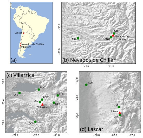
Figure 1.
Geographic position of the studied volcanoes in South America (panel (a)) and visible cameras (panels (b–d)) considered in this work (see Figure 2). Red triangles indicate volcanic vents, and green circles represent the positions of visible cameras.

Table 1.
Set of visible cameras analyzed in this study. We include information of the angular range considered to compute the different horizon profiles in the software PhixCam (see Section 2.2).
For Villarrica and Nevados de Chillán, we dispose of high-resolution DEMs of their crater areas elaborated with Pleiades images, framed on the collaborative program GeoHazSA Supersite CNES. In most of the studied visible cameras, a significant portion of the volcanic edifice framed in the images (Figure 2) is contained in our high-resolution DEMs. The only exception was the ARA camera of the Nevados de Chillán volcanic system; for this camera, as well as for the cameras of the Láscar volcano, we used elevation data from SRTM-30 m [34] to perform the analysis described below.
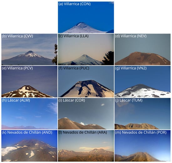
Figure 2.
Reference frames of the visible cameras considered in this work.
2.2. The Software
PhixCam (Figure 3 and Table 2) is a software that allows the user to analyze DEMs in order to characterize the volcano topography observed from a given position and compare it with images captured by visible cameras, allowing their georeferentiation, including tilt and roll rotation (Figure 4a). The software also allows estimation of the height associated with each pixel of the images when different emission directions of volcanic products are considered. Please note that PhixCam is not intended to be used in real time but applied after significant changes in camera orientation (e.g., due to maintenance tasks) to calibrate this device and obtain a set of operative matrices that will allow to interpret the position of each pixel of the images in terms of elevation above sea level. PhixCam includes four modules, each one hosted in a different tab (Figure 3):
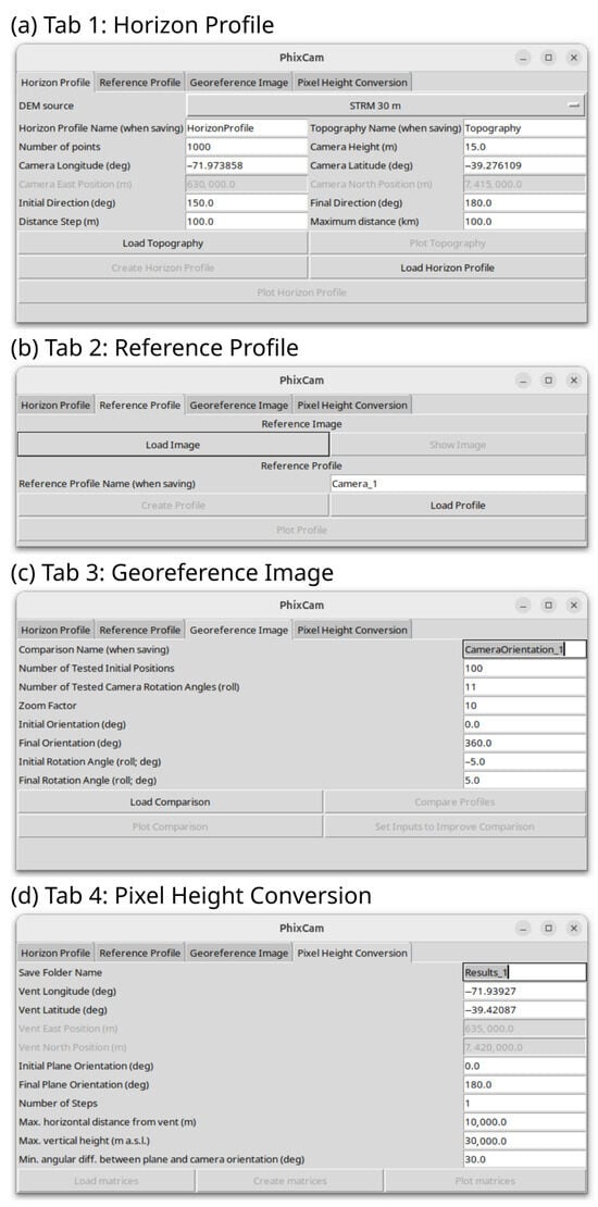
Figure 3.
User-friendly interface of the program PhixCam.

Table 2.
Functions included in the program PhixCam.
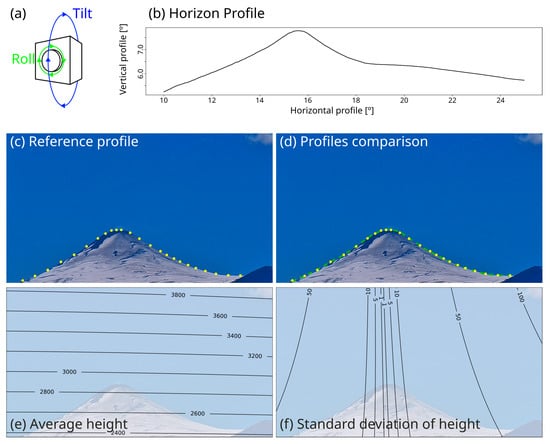
Figure 4.
(a) Scheme of the tilt and roll rotation directions of a camera. (b) Example of a horizon profile computed by PhixCam (yellow dots). (c) Example of a reference profile traced in PhixCam (green dashed line). (d) Fit between the reference and horizon profiles (see Table 3). (e,f) Illustrative examples of the results produced by PhixCam, including the average height of each pixel for a range of directions of emission of volcanic products (N60E to N120E; panel (e)) and the associated standard deviation (panel (f)). All the example images presented here are associated with the camera CON of Villarrica volcano.
- (a)
- Horizon Profile Module allows the user to set the camera position, a range for the observation direction and a few terms to define the required resolution of the horizon profile. Based on this data, the tool is able to import or download the topography and compute the horizon profile when an observer looks from the camera position in the range of directions defined by the user (Figure 4b). This information is recorded in two vectors with elements, and , which represent the pan and tilt angles of the horizon profile, respectively (see Figure 4b; is defined by the user, being equal to 2000 in all the calibrations presented here). The algorithm is simply an iterative procedure that computes, for variable observation angles from the camera position, the largest tilt inclination (Figure 4a) that intersect the imported/downloaded topography. The code also includes functions to load a previously computed horizon profile and to plot these data (Table 2).
- (b)
- Reference Profile Module allows the user to import a reference image of the visible camera under examination and trace manually, by means of a user-friendly, interactive graphical interface, the observed profile at the horizon (Figure 4c). The reference profile is saved in two vectors with elements, called and , that represent the horizontal and vertical coordinates in pixel units of the points outlined by the user in the reference image (see Figure 4c; ranges from 16 to 49 in the calibrations presented here). The code includes functions to load and plot this information as well (Table 2).
- (c)
- Georeference Image Module permits the user to iterate over the horizon profile, considering different positions, zooms and rotations of the camera (tilt and roll), in order to fit these data to the reference profile. Thereby, the camera visual field is georeferenced, allowing assignation of a vector to each pixel of the captured images (Table 2 and Figure 4d). The algorithm consists of two stages.First, the code iterates over the observation direction () and the angle of view (). For each geometric configuration, the code recognizes the portion of the horizon profile actually framed, which is the subset of containing all the elements of in the interval . A third iteration parameter is then introduced: the tilt angle (), which is used to rotate the framed horizon profile with respect to a horizontal line, giving rise to a set of rotated, framed points that are controlled by three iteration variables: . Note that the iteration limits and steps are defined by the user; for the calibrations presented here, we adopted the default setup of the code. For each iteration cycle, we have two sets of points: the reference profile and the rotated, framed horizon profile . After the application of a normalization routine to set the same horizontal distance between the first and the last components of and , the software computes a series of simple statistical parameters that are sequentially analyzed to discard the geometric configurations that fit poorly the reference data. These statistical parameters, extracted from the normalized vectors and are: (1) ratio of total vertical variation to total horizontal variation in the framed profile, (2) linear term in a first-order polynomial fit, and (3) quadratic term in a second-order polynomial fit. From this iteration process, the code extracts a series of geometric configurations that are candidates to fit the reference profile.In the second stage, the algorithm iterates on the vicinity of these geometric configurations, reanalyzes the described statistical parameters and, for the geometric configurations that are not a priori discarded, the code minimizes the mean squared distance to recognizes the one that best fits the reference profile. Thereby, the code is able to extract the optimal set and thus identify issues related to camera leveling, which must be considered when these images are processed and used to quantify eruption parameters.
- (d)
- Pixel-Height Conversion Module permits to compute the height associated with each pixel of the captured image when a given vertical plane is intersected. This plane is expected to represent the emission plane of volcanic products. When volcanic plumes are analyzed, it is expected to be consistent with the wind field. When ballistic fragments are studied, this plane is related to the launch direction. Because this information is frequently unclear, this module allows the user to define a variation range for the azimuth of this plane and to statistically analyze the height of each pixel of the image in terms of different percentiles, average value and standard deviation (Table 2).
3. Results
The described calibration strategy, implemented in the program PhixCam, was applied independently to 13 visible cameras, whose results are included in Table 3. Roll rotations (Figure 4a) of the studied visible cameras range between <−3° (i.e., anticlockwise rotation; AND camera of Nevados de Chillán volcanic complex and COR camera of Láscar volcano) and >3° (i.e., clockwise rotation; PUC and VN2 cameras of Villarrica volcano). Only three of the used cameras present a roll rotation smaller than 1° (LLA, NEV and PCV; Villarrica volcano), while the mean deviation from horizontality is about 2.25° (median value of 2.14°). Tilts (Figure 4a) vary between <5° (ARA camera of Nevados de Chillán volcanic complex) and ∼25° (VN2 camera of Villarrica volcano and POR camera of Nevados de Chillán volcanic complex). As expected, the largest values of tilt rotation are typically associated with proximal cameras, while distal cameras present tilt rotations lower than 10°. The largest error measures are linked to low-resolution elevation data (e.g., those at Láscar volcano) or calibrations for which the high-resolution DEM only covers a limited part of the volcanic edifice framed by the camera (e.g., CVV camera of Villarrica volcano and AND and POR cameras of Nevados de Chillán volcanic complex; see Table 3).

Table 3.
Results of the PhixCam-based georeferentiation of the view field of visible cameras.
In Figure 5, for the studied visible cameras, we present the results of height above sea level for each pixel of the images if it were assumed that the detectable volcanic products are emitted perpendicularly to the observation angle. In all cases, the computed height at the vent zone is consistent with the altitude of the studied volcanoes, which can be used as a first-order validation of our calibration, exclusively based on a shape comparison of the relief observed at the horizon (in other words, vent elevation is not an input of the calibration routine). The studied captures of surveillance cameras of Villarrica volcano are able to track plumes of heights lower than (∼2 km above the crater; Figure 5). Note, however, that these cameras are set up to take zoomed-out photos regularly and can be manipulated remotely in the case of eruptions with higher volcanic plumes. On the other hand, the studied visible cameras at Láscar volcano and Nevados de Chillán volcanic complex are able to track column heights of up to (∼15 km above the crater) and (∼3 km above the crater), respectively (Figure 5).
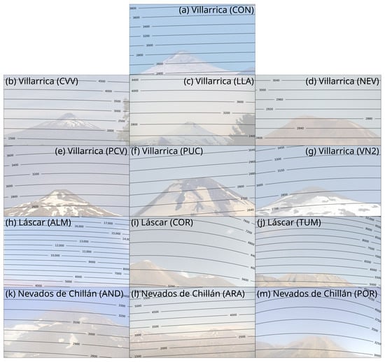
Figure 5.
Height above sea level of each pixel of the visible cameras considered in this study when volcanic products are emitted perpendicular to the observation direction.
The effect of roll rotation is evident in the pixel-to-height conversion matrices, some of which are highly asymmetrical (e.g., COR camera of Láscar volcano and PUC camera of Villarrica volcano; Figure 5). On the other hand, the high curvature of some of the height isolines is related to proximal location and/or high tilt of the monitoring instruments (COR camera of Láscar volcano and POR camera of Nevados de Chillán volcanic complex). Note that high curvatures are not evident in the height isolines of Villarrica cameras because of their limited view fields (Table 3), which are smaller than 25° in all the cases, in contrast to the other analyzed volcanoes (e.g., POR camera of Nevados de Chillán volcano; TUM and COR cameras of Láscar volcano).
In order to highlight the critical influence of wind direction in video monitoring of eruption parameters, Figure 6 presents the isolines of height above sea level for the studied instruments of Villarrica volcano, considering different planes of propagation of pyroclastic material: N-S (left-hand panels), NE-SW (center panels) and W-E (right-hand panels). As can be inferred from Figure 6, the effect of wind field in height isolines is able to generate significant differences in the estimates of column height. Propagation of volcanic products almost parallel to the observation direction significantly reduces the applicability of surveillance cameras in volcano monitoring, as is observed under specific wind conditions for LLA (Figure 6h) and PCV (Figure 6m) cameras of Villarrica volcano, stressing the critical need to install and integrate surveillance cameras on different flanks of volcanoes considering the orientation of dominant winds. The critical effect of wind is also observed in Figure 7, where we present the record of a low-intensity event that occurred on 21 July 2024 at Villarrica volcano (17:53 local time, visible camera PCV; Figure 7a–h). We present the comparison between height estimates derived from the application of a PhixCam-based calibration (Figure 7i,j, considering winds blowing in the range N300E–N330E) and a calibration based on regularly spaced horizontal isolines, which is the approach currently adopted by Sernageomin. Results show comparable heights in the vicinity of the vent, while a clear and increasing bias in height estimates emerges when the plume approaches the margins of the image, with a height difference above the crater of more than . These discrepancies may induce significant differences in any derived estimate of volcanological interest, such as the mass eruption rate [35,36].
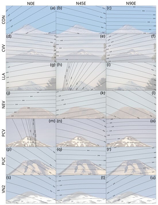
Figure 6.
Height above sea level of each pixel of the georeferenced Villarrica visible cameras when different directions of emission of volcanic products are considered. Please note that two of these images present isolines that do not span over the entire frames because estimates of column height or horizontal distance from the vent are unrealistically high in these portions of the images. This occurs when products are emitted nearly parallel to the camera orientation (see Figure 1).
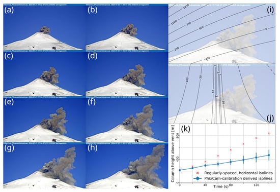
Figure 7.
(a–h) Frames of a low-intensity emission of pyroclasts at Villarrica volcano (21 July 2024; PCV camera). (i,j) Average and standard deviation of the height above the vent () associated with products dispersed towards N300E–N330E. (k) Comparison of the estimates of height computed using regularly spaced horizontal isolines and those obtained by means of a PhixCam-based calibration of the camera orientation.
4. Discussion
4.1. Operative Potential of PhixCam
Modern volcano monitoring involves the collection of geophysical and geochemical signals and their interpretation in terms of subsurface and surficial processes [37,38]. Direct observation of the eruption of volcanic products is one of the most important constraints that permits linking geophysical signals and atmospheric processes. In this context, visible cameras are particularly useful instruments. These monitoring devices are frequently adopted to quantify column height in explosive eruptions [9,11], describe the kinematics of ballistic projectiles [39,40] and recognize morphology changes in effusive activity. Through conceptual and numerical models, these parameters can be adopted to quantify first-order variables of volcanic eruptions from a hazard perspective, such as mass discharge rate or launch velocity of pyroclasts [16,41,42,43]. In addition, visible cameras are essential for dimensioning intempestive eruptive activity or unrest of fast triggering. However, the complexity of data collection from visible cameras is often underestimated in the literature when compared to other monitoring techniques. The main sources of uncertainty are related to the frequently unclear camera orientation and the direction of emission of volcanic products [9,10]. In view of this, here we presented PhixCam, an open-source Python tool that facilitates a series of tasks needed to take advantage of and improve our interpretation capacity of results provided by visible cameras in the context of volcano monitoring. This code allows volcanologists to perform the following tasks:
- (a)
- Recognize the exact position of the image framed by a visible camera, including camera orientation and rotation angles (roll and tilt, Figure 4a).
- (b)
- Use this information to interpret each pixel of the images in terms of position above the crater when a given emission direction of volcanic products is considered.
- (c)
- Propagate the uncertainty in the emission direction of volcanic products to our estimates of eruption parameters such as plume height or distance reached by ballistic projectiles.
The PhixCam calibration approach is based on the horizon matching strategy. When compared to other procedures, such as the chessboard approach or calibrations based on the position of stars or the analysis of terrain features [9,10], horizon matching places fewer requirements on the analyzed captures, favoring reproducibility and applicability of this approach to both cameras recording complex topographies (e.g., ALM camera of Láscar volcano) and cameras that capture exclusively the summit part of an almost perfectly conical stratovolcano, i.e., in absence of clear topographic markers able to guide calibration (see Figure 2). Thereby, even if some additional guide elements have revealed to be useful to improve the precision of visible cameras calibrations [10], which can be considered a limitation of PhixCam, our strategy is more versatile and, thus, a reasonable alternative for volcano observatories dealing with large sets of visible cameras characterized by strongly variable features in terms of the topography present in the frames. Further limitations of PhixCam are related to the user-controlled definition of the reference profile, which may affect reproducibility of results, the assumption of pyroclast dispersion on a vertical plane centered in the volcano vent, and intrinsic limitations related to the frequently unknown propagation direction of volcanic products.
Analysis of a set of visible cameras from the Chilean volcano monitoring system shows the operative potential of PhixCam to georeference them and improve any derived quantitative measure. Note that the studied frames include a wide variety of topography profiles and can be used for both systems of central (e.g., Villarrica volcano) and distributed volcanism (e.g., Laguna del Maule Volcanic Field). From our results, we clearly observe the critical effect of adequately considering leveling issues of instruments when taking eruption estimates in order to avoid biases in results. In fact, non-negligible roll rotations (Figure 4a) have revealed to be frequent, with deviation from horizontality of up to about 5° in the set of visible cameras analyzed.
The interplay between camera orientation and propagation direction of volcanic material is also crucial in controlling the amount and quality of the data a visible camera is able to provide, which must be considered properly when a network of surveillance instruments is installed and processed. This aspect is also addressed in this software by comparing the calibrated camera orientation with planes that represent possible transport directions of volcanic products. From an operative point of view, PhixCam provides matrices of pixel-to-height conversion for different planes of propagation of pyroclasts, with the same dimensions of the analyzed captures. These products can be selected as a function of the atmospheric conditions in volcanic observatories in order to improve data collection in terms of precision and uncertainty quantification. PhixCam also allows us to address in advance the full range of coverage of a camera and the quality of its data, helping to decide the needs of new instruments or installation sites.
Although the DEM resolution requirements of PhixCam for a specific volcano depends on the complexity of the topography observed from the camera, as a testing exercise, we recalibrated all the cameras using SRTM-30 m [34] elevation data to compute the horizon profile and compare them with calibrations derived from the use of high-resolution DEMs. Recalibration results are presented in Table 4, where we can observe that the error measures tend to be significantly larger for low-resolution elevation data, as expected, and that slight to moderate differences in the roll angle and view field are introduced, as well as small changes in the tilt angle. Reduction in fit quality is particularly relevant for cameras located near the vent (AND and POR cameras of Nevados de Chillán volcanic complex) and cameras with a limited view field (NEV camera of Villarrica volcano). However, even if discrepancies are, in general, not negligible, the orientation differences translate into remarkably limited discrepancies in the pixel-to-height matrices produced by PhixCam (Figure 8), with values of the order of a few tens of meters, much smaller than the uncertainty derived from the typically poorly-constrained direction of pyroclast emission.

Table 4.
Results of the PhixCam-based georeferentiation of the view field of visible cameras using exclusively SRTM-30 m topography data.
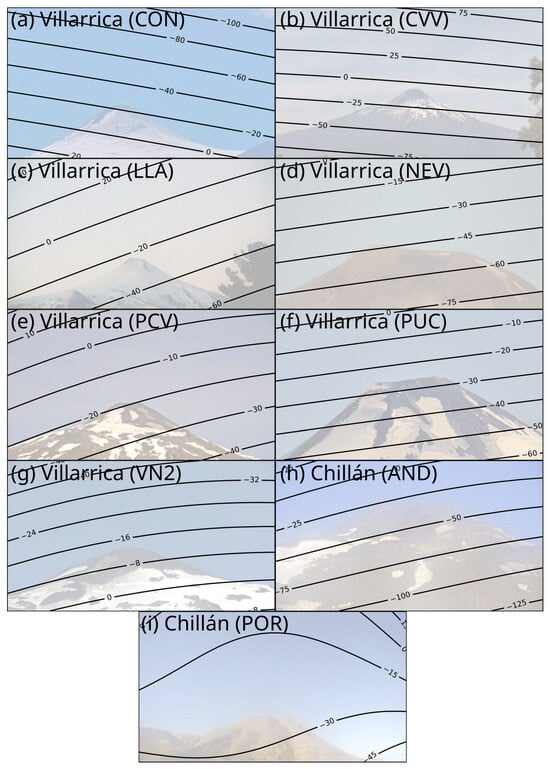
Figure 8.
Height difference between the pixel-to-height matrices computed using high-resolution DEMs and SRTM-30 m elevation data.
4.2. Analysis of Historical Data
In addition to the calibration of static surveillance cameras, PhixCam has been tested to reanalyze historical images of volcanic eruptions. In the absence of significant modifications of the surrounding topography, historical images can be georeferenced, and, thus, relevant eruptive parameters can be retrieved from them. In Figure 9b we present a photo of the 1961 eruption of Calbuco volcano, taken somewhere along the Correntoso route towards Chepo Lake, in Southern Chile. By iterating along the above mentioned route, it was possible to recognize a zone where the topography is consistent with the photo (Figure 9a), and, thus, it was possible to georeference it and estimate the plume height (Figure 9c). By assuming that winds blow towards the east, which is the most frequent wind scenario in the study area at heights between 5 and , we calculated a plume height of about (Figure 9d). This value is much higher than that described in the available reports of this eruption for February 1961 [44,45]. In fact, although a ∼12 km height plume was reported for 10 March 1961, during the period that the photo was taken, the activity was described as only characterized by columns of water steam. If we assume that the date presented in the photo is correct (i.e., 21 February 1961), this application of PhixCam serves as an illustrative example of the relevant information that we can retrieve from the analysis and georeferentiation of the archive of volcanic eruptions, allowing improvement of our characterization of the behavior of active volcanoes during recent events and thus of our assessments of volcanic hazard.
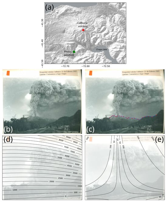
Figure 9.
Application of PhixCam to the analysis of the historical archive: (a) Shaded relief map of Calbuco volcano, with indications of the position from which we interpret the picture presented in panel b was taken. (b) Photo of the Calbuco volcano eruption of 21 February 1961 [46]. This photo is part of the Chilean National archive and is labeled with the following text: “Calbuco volcano eruption, 21 February 1961. Correntoso route to Chapo lake”. (c) Comparison of topography traced in the image (red markers) and the observed relief from the position from which, according to our results, this photo was taken (blue, dashed line). Results indicate that the image presents a roll rotation of 2.36° (anticlockwise). (d) Average height of each pixel of the image when volcanic products are assumed to have been emitted from the active vent towards the east (between N70E and N110E), while the standard deviation is presented in panel (e).
5. Conclusions
A new open-source, freely downloadable and user-friendly Python tool named PhixCam is presented here, which has been designed to facilitate a series of tasks that will allow volcanologists in observatories to improve their estimates of eruption parameters based on the record of visible cameras. This program allows to deal with issues related to camera leveling and the uncertainty in the propagation direction of volcanic products, offering a framework to track the height of volcanic products recognized in captures of visible cameras.
Author Contributions
Conceptualization, A.A., G.P. and F.B.; methodology, A.A., G.P., F.B. and R.C.; software, A.A.; validation, A.A., G.P. and M.G.-R.; writing—original draft preparation, A.A.; writing—review and editing, All authors; visualization, A.A. and G.P. All authors have read and agreed to the published version of the manuscript.
Funding
ANID provided financial support to AA via ANID FONDECYT de Iniciación 11251802.
Data Availability Statement
The Python program PhixCam and benchmark tests are available at a GitHub repository (https://github.com/AlvaroAravena/PhixCam, accessed on 13 July 2025).
Conflicts of Interest
Author Francisco Bucchi was employed by Planeta Tallado EIRL. The remaining authors declare that the research was conducted in the absence of any commercial or financial relationships that could be construed as a potential conflict of interest.
References
- Calvari, S.; Intrieri, E.; Di Traglia, F.; Bonaccorso, A.; Casagli, N.; Cristaldi, A. Monitoring crater-wall collapse at active volcanoes: A study of the 12 January 2013 event at Stromboli. Bull. Volcanol. 2016, 78, 1–16. [Google Scholar] [CrossRef]
- Scollo, S.; Prestifilippo, M.; Bonadonna, C.; Cioni, R.; Corradini, S.; Degruyter, W.; Rossi, E.; Silvestri, M.; Biale, E.; Carparelli, G.; et al. Near-real-time tephra fallout assessment at Mt. Etna, Italy. Remote Sens. 2019, 11, 2987. [Google Scholar] [CrossRef]
- Forte, P.; Rodríguez, L.; Paz, M.P.J.; García, L.C.; Segura, Y.A.; Bustos, E.; Moya, C.P.; Espinoza, E.; Vallejo, S.; Agusto, M. Volcano monitoring in latin america: Taking a step forward: Preface to special issue on volcano observatories in Latin America. Volcanica 2021, 4, vii–xxxiii. [Google Scholar] [CrossRef]
- Budi-Santoso, A.; Beauducel, F.; Nandaka, I.G.M.A.; Humaida, H.; Costa, F.; Widiwijayanti, C.; Iguchi, M.; Métaxian, J.P.; Rudianto, I.; Rozin, M.; et al. The Merapi volcano monitoring system. In Merapi Volcano: Geology, Eruptive Activity, and Monitoring of a High-Risk Volcano; Springer: Berlin/Heidelberg, Germany, 2023; pp. 409–436. [Google Scholar]
- Hidalgo, S.; Bernard, B.; Mothes, P.; Ramos, C.; Aguilar, J.; Andrade, D.; Samaniego, P.; Yepes, H.; Hall, M.; Alvarado, A.; et al. Hazard assessment and monitoring of Ecuadorian volcanoes: Challenges and progresses during four decades since IG-EPN foundation. Bull. Volcanol. 2023, 86, 4. [Google Scholar] [CrossRef]
- Vásconez Müller, A.; Bernard, B.; Vasconez, F.J. Near-real-time ash cloud height estimation based on GOES-16 satellite imagery: A case study of the 2022–2023 eruption of Cotopaxi volcano, Ecuador. Volcanica 2024, 7, 405–419. [Google Scholar] [CrossRef]
- Patrick, M.R.; Kauahikaua, J.P.; Antolik, L. MATLAB tools for improved characterization and quantification of volcanic incandescence in Webcam imagery: Applications at Kilauea Volcano, Hawaii. US Geol. Surv. Tech. Methods 2010, 13, 1–16. [Google Scholar]
- Coltelli, M.; d’Aranno, P.J.; De Bonis, R.; Guerrero Tello, J.F.; Marsella, M.; Nardinocchi, C.; Pecora, E.; Proietti, C.; Scifoni, S.; Scutti, M.; et al. The use of surveillance cameras for the rapid mapping of lava flows: An application to Mount Etna Volcano. Remote Sens. 2017, 9, 192. [Google Scholar] [CrossRef]
- Scollo, S.; Prestifilippo, M.; Pecora, E.; Corradini, S.; Merucci, L.; Spata, G.; Coltelli, M. Eruption column height estimation of the 2011–2013 Etna lava fountains. Ann. Geophys. 2014, 57, S0214. [Google Scholar] [CrossRef]
- Barnie, T.; Hjörvar, T.; Titos, M.; Sigurðsson, E.M.; Pálsson, S.K.; Bergsson, B.; Ingvarsson, Þ.; Pfeffer, M.A.; Barsotti, S.; Arason, Þ.; et al. Volcanic plume height monitoring using calibrated web cameras at the Icelandic Meteorological Office: System overview and first application during the 2021 Fagradalsfjall eruption. J. Appl. Volcanol. 2023, 12, 4. [Google Scholar] [CrossRef]
- Aravena, A.; Carparelli, G.; Cioni, R.; Prestifilippo, M.; Scollo, S. Toward a Real-Time Analysis of Column Height by Visible Cameras: An Example from Mt. Etna, in Italy. Remote Sens. 2023, 15, 2595. [Google Scholar] [CrossRef]
- Alatorre-Ibargüengoitia, M.A.; Morales-Iglesias, H.; Ramos-Hernández, S.G.; Jon-Selvas, J.; Jiménez-Aguilar, J.M. Hazard zoning for volcanic ballistic impacts at El Chichón Volcano (Mexico). Nat. Hazards 2016, 81, 1733–1744. [Google Scholar] [CrossRef]
- Fitzgerald, R.; Tsunematsu, K.; Kennedy, B.; Breard, E.; Lube, G.; Wilson, T.; Jolly, A.; Pawson, J.; Rosenberg, M.; Cronin, S. The application of a calibrated 3D ballistic trajectory model to ballistic hazard assessments at Upper Te Maari, Tongariro. J. Volcanol. Geotherm. Res. 2014, 286, 248–262. [Google Scholar] [CrossRef]
- Selva, J.; Costa, A.; Sandri, L.; Macedonio, G.; Marzocchi, W. Probabilistic short-term volcanic hazard in phases of unrest: A case study for tephra fallout. J. Geophys. Res. Solid Earth 2014, 119, 8805–8826. [Google Scholar] [CrossRef]
- Tadini, A.; Pardini, F.; Bevilacqua, A.; Bernard, B.; Samaniego, P.; Vitturi, M.d.; Aravena, A.; Hidalgo, S.; Roche, O.; Azzaoui, N.; et al. Probabilistic tephra fallout hazard maps for Sangay volcano, Ecuador. Bull. Volcanol. 2025, 87, 1–23. [Google Scholar] [CrossRef]
- Williams, S.; Beckett, F.M.; Leadbetter, S.J.; Phillips, J.C.; Lee, A.; Wooodhouse, M.J. Incorporating eruption source parameter and meteorological variability in the generation of probabilistic volcanic ash hazard forecasts. J. Geophys. Res. Atmos. 2025, 130, e2024JD042280. [Google Scholar] [CrossRef]
- Baldo, M.; Bicocchi, C.; Chiocchini, U.; Giordan, D.; Lollino, G. LIDAR monitoring of mass wasting processes: The Radicofani landslide, Province of Siena, Central Italy. Geomorphology 2009, 105, 193–201. [Google Scholar] [CrossRef]
- Scollo, S.; Boselli, A.; Coltelli, M.; Leto, G.; Pisani, G.; Spinelli, N.; Wang, X. Monitoring Etna volcanic plumes using a scanning LiDAR. Bull. Volcanol. 2012, 74, 2383–2395. [Google Scholar] [CrossRef]
- Plank, S.; Nolde, M.; Richter, R.; Fischer, C.; Martinis, S.; Riedlinger, T.; Schoepfer, E.; Klein, D. Monitoring of the 2015 Villarrica volcano eruption by means of DLR’s experimental TET-1 satellite. Remote Sens. 2018, 10, 1379. [Google Scholar] [CrossRef]
- Coppola, D.; Laiolo, M.; Cigolini, C.; Massimetti, F.; Delle Donne, D.; Ripepe, M.; Arias, H.; Barsotti, S.; Parra, C.B.; Centeno, R.G.; et al. Thermal remote sensing for global volcano monitoring: Experiences from the MIROVA system. Front. Earth Sci. 2020, 7, 362. [Google Scholar] [CrossRef]
- Manzo, M.; Aiesi, G.; Boselli, A.; Consoli, S.; Damiano, R.; Di Donfrancesco, G.; Saraceno, B.; Scollo, S. Upgraded Three-Wavelength Lidar for Real-Time Observations of Volcanic Aerosol Optical and Microphysical Properties at Etna (Italy): Calibration Procedures and Measurement Tests. Sensors 2024, 24, 1762. [Google Scholar] [CrossRef]
- Di Bella, G.S.; Corradino, C.; Cariello, S.; Torrisi, F.; Del Negro, C. Advancing volcanic activity monitoring: A near-real-time approach with remote sensing data fusion for radiative power estimation. Remote Sens. 2024, 16, 2879. [Google Scholar] [CrossRef]
- Vásconez, F.; Moussallam, Y.; Harris, A.J.; Latchimy, T.; Kelfoun, K.; Bontemps, M.; Macías, C.; Hidalgo, S.; Córdova, J.; Battaglia, J.; et al. VIGIA: A thermal and visible imagery system to track volcanic explosions. Remote Sens. 2022, 14, 3355. [Google Scholar] [CrossRef]
- Ospina, C.; Narvaez, A.; Corchuelo, I. Field calibration of volcanic surveillance cameras. In Journal of Physics: Conference Series, Proceedings of the 5th Colombian Conference of Engineering Physics (V CNIF), Medellin, Colombia, 26–30 September 2016; IOP Publishing: Bristol, UK, 2017; Volume 850, p. 012010. [Google Scholar]
- Zhang, Z. Flexible camera calibration by viewing a plane from unknown orientations. In Proceedings of the Seventh IEEE International Conference on Computer Vision, Kerkyra, Greece, 20–27 September 1999; IEEE: Piscataway, NJ, USA, 1999; Volume 1, pp. 666–673. [Google Scholar]
- Antuña-Sánchez, J.C.; Román, R.; Bosch, J.L.; Toledano, C.; Mateos, D.; González, R.; Cachorro, V.; de Frutos, A. ORION software tool for the geometrical calibration of all-sky cameras. PLoS ONE 2022, 17, e0265959. [Google Scholar] [CrossRef] [PubMed]
- Stern, C.R. Active Andean volcanism: Its geologic and tectonic setting. Rev. Geol. Chile 2004, 31, 161–206. [Google Scholar] [CrossRef]
- Cembrano, J.; Lara, L. The link between volcanism and tectonics in the southern volcanic zone of the Chilean Andes: A review. Tectonophysics 2009, 471, 96–113. [Google Scholar] [CrossRef]
- Amigo, A. Volcano monitoring and hazard assessments in Chile. Volcanica 2021, 4, 1–20. [Google Scholar] [CrossRef]
- Benet, D.; Costa, F.; Pedreros, G.; Cardona, C. The volcanic ash record of shallow magma intrusion and dome emplacement at Nevados de Chillán Volcanic complex, Chile. J. Volcanol. Geotherm. Res. 2021, 417, 107308. [Google Scholar] [CrossRef]
- Cardona, C.; Gil-Cruz, F.; Franco-Marín, L.; San Martín, J.; Valderrama, O.; Lazo, J.; Cartes, C.; Morales, S.; Hernández, E.; Quijada, J.; et al. Volcanic activity accompanying the emplacement of dacitic lava domes and effusion of lava flows at Nevados de Chillán Volcanic Complex–Chilean Andes (2012 to 2020). J. Volcanol. Geotherm. Res. 2021, 420, 107409. [Google Scholar] [CrossRef]
- Gaete, A.; Walter, T.R.; Bredemeyer, S.; Zimmer, M.; Kujawa, C.; Franco Marin, L.; San Martin, J.; Bucarey Parra, C. Processes culminating in the 2015 phreatic explosion at Lascar volcano, Chile, evidenced by multiparametric data. Nat. Hazards Earth Syst. Sci. 2020, 20, 377–397. [Google Scholar] [CrossRef]
- Sernageomin. Ranking de riesgo específico de volcanes activos de Chile 2023. 2023. Available online: https://rnvv.sernageomin.cl/wp-content/uploads/sites/2/2023/10/Ranking-2023_tabloide_20231012.pdf (accessed on 13 July 2025).
- Farr, T.G.; Rosen, P.A.; Caro, E.; Crippen, R.; Duren, R.; Hensley, S.; Kobrick, M.; Paller, M.; Rodriguez, E.; Roth, L.; et al. The shuttle radar topography mission. Rev. Geophys. 2007, 45, RG2004. [Google Scholar] [CrossRef]
- Sparks, R. The dimensions and dynamics of volcanic eruption columns. Bull. Volcanol. 1986, 48, 3–15. [Google Scholar] [CrossRef]
- Carey, S.; Bursik, M. Volcanic plumes. In The Encyclopedia of Volcanoes; Elsevier: Amsterdam, The Netherlands, 2015; pp. 571–585. [Google Scholar]
- Biggs, J.; Pritchard, M.E. Global volcano monitoring: What does it mean when volcanoes deform? Elements 2017, 13, 17–22. [Google Scholar] [CrossRef]
- Acocella, V.; Ripepe, M.; Rivalta, E.; Peltier, A.; Galetto, F.; Joseph, E. Towards scientific forecasting of magmatic eruptions. Nat. Rev. Earth Environ. 2024, 5, 5–22. [Google Scholar] [CrossRef]
- Taddeucci, J.; Alatorre-Ibargüengoitia, M.; Cruz-Vázquez, O.; Del Bello, E.; Scarlato, P.; Ricci, T. In-flight dynamics of volcanic ballistic projectiles. Rev. Geophys. 2017, 55, 675–718. [Google Scholar] [CrossRef]
- Tsunematsu, K.; Ishii, K.; Yokoo, A. Transport of ballistic projectiles during the 2015 Aso Strombolian eruptions. Earth Planets Space 2019, 71, 1–14. [Google Scholar] [CrossRef]
- Degruyter, W.; Bonadonna, C. Improving on mass flow rate estimates of volcanic eruptions. Geophys. Res. Lett. 2012, 39. [Google Scholar] [CrossRef]
- Harris, A.J.; Ripepe, M.; Hughes, E.A. Detailed analysis of particle launch velocities, size distributions and gas densities during normal explosions at Stromboli. J. Volcanol. Geotherm. Res. 2012, 231, 109–131. [Google Scholar] [CrossRef]
- Engwell, S.; Mastin, L.G.; Bonadonna, C.; Barsotti, S.; Deligne, N.I.; Oladottir, B.A. Characterising, quantifying, and accessing eruption source parameters of explosive volcanic eruptions for operational simulation of tephra dispersion: A current view and future perspectives. Bull. Volcanol. 2024, 86, 67. [Google Scholar] [CrossRef]
- Klohn, E. The February 1961 eruption of Calbuco volcano. Bull. Seismol. Soc. Am. 1963, 53, 1435–1436. [Google Scholar] [CrossRef]
- Daga, R.; Guevara, S.R.; Poire, D.G.; Arribére, M. Characterization of tephras dispersed by the recent eruptions of volcanoes Calbuco (1961), Chaitén (2008) and Cordón Caulle Complex (1960 and 2011), in Northern Patagonia. J. S. Am. Earth Sci. 2014, 49, 1–14. [Google Scholar] [CrossRef]
- Grassau, K. Erupción del volcán Calbuco, camino Correntoso a lago Chepo. Donated by Elna Stange Ohlsen. 1961. Available online: https://www.memoriasdelsigloxx.cl/601/w3-article-85680.html (accessed on 13 July 2025).
Disclaimer/Publisher’s Note: The statements, opinions and data contained in all publications are solely those of the individual author(s) and contributor(s) and not of MDPI and/or the editor(s). MDPI and/or the editor(s) disclaim responsibility for any injury to people or property resulting from any ideas, methods, instructions or products referred to in the content. |
© 2025 by the authors. Licensee MDPI, Basel, Switzerland. This article is an open access article distributed under the terms and conditions of the Creative Commons Attribution (CC BY) license (https://creativecommons.org/licenses/by/4.0/).