Abstract
Catastrophic landslides occur frequently in Guizhou Province, China, and the landslides in this area have special geomorphological, geological, and anthropogenic features. In order to detect and explore the distribution pattern and control factors of active landslides in Guizhou, firstly, a total of 693 active landslides throughout Guizhou Province were mapped based on the deformation rate, which was obtained by spatiotemporal filtering and Intermittent Small Baseline Subset (ISBAS) Interferometric Synthetic Aperture Radar (InSAR) techniques. Then, the relationships between the detected landslides and elevation, aspect, slope gradient, and stratigraphic lithology were analysed. Moreover, it was found that the landslides were mainly concentrated in three stratigraphic combinations, that is , , and . Thereafter, the correlation coefficients between the landslide density and elevation and distance to the stratigraphic boundary were 0.54 and −0.19, indicating that the distribution of landslides was significantly controlled by the elevation and the boundary of specific stratigraphic combinations. Finally, we chose a typical landslide to explore how landslide development was controlled by the combined effects of elevation and stratigraphy by using ascending and descending InSAR results. We revealed that landslides occurred primarily in areas with a steep slope and a stratigraphy characterized by mudstone and sandstone.
1. Introduction
The Yunnan-Guizhou Plateau in southwestern China is one of the largest karst mountain areas in the world, with special geomorphological and geological features. The rocks are mainly carbonate and clastic, with a special structure. In recent decades, catastrophic landslides have frequently occurred in this area. For example, on 18 February 2013, a rockslide in Longchang County, Guizhou Province, China, buried five people and six houses and dammed a river [1]. On 28 August 2017, a long-runout landslide in Pusa Village, Zhangjiawan Town, Guizhou Province, China, killed 35 people [2]. Extensive development of folded mountains leads to the existence of soft and weak interlayers in rock, which control the strength of the rock bodies. In addition, this karst mountain area has widely developed rich coal seams. Consequently, long-term and large-scale underground mining has become a major triggering factor for landslides [3,4]. Therefore, these characteristics determine the particularities of landslide detection in this region.
To date, the satellite-based Interferometric Synthetic Aperture Radar (InSAR) technique can be used to sense slight surface deformation in mountainous areas, providing effective means for landslide detection over large areas [5,6,7,8,9,10]. Bekaert et al. detected slow-moving landslides by using a novel InSAR and pixel clustering method in the Himalayas, centred on the Trishuli River catchment, Nepal [11]. Bouali et al. investigated landslides in the Palos Verdes Peninsula, California, by persistent scatterer interferometry and classified the detected landslides into different categories [12]. Even in the Guizhou karst mountain regions, Zhu et al. detected active landslides in western Guizhou Province, China, by combining Sentinel-1 and ALOS/PALSAR-2 data and categorized the landslides into natural, reservoir, and mining-induced landslides [13]. Shen et al. obtained the deformation of potential landslides in Bijie City, Guizhou, with RADARSAT-2 and Sentinel-1 datasets using an improved InSAR technique [14]. However, as for the entire Guizhou Province, there remain some key problems in active landslide detection based on surface deformation. Most importantly, even though Yue et al. has shown the relationship between the spatial distribution pattern of landslides and environmental factors in Guizhou Province [15] and Yao et al. has illustrated the influencing factors associated with the distribution of landslides in Bijie, Guizhou [16], few studies have focused on the relationship between active landslides and stratigraphic lithology.
Therefore, in this study, we applied Sentinel-1 SAR images to detect active landslides across Guizhou Province, China, and verified the results using Google Earth optical images. To this end, firstly, the Intermittent Small Baseline Subset (ISBAS) InSAR technique was used to calculate the deformation velocity and time series with ascending and descending Sentinel-1 SAR datasets, where the patched InSAR processing strategy was involved to correct the localized errors. Then, a spatiotemporal filtering method was applied to refine the InSAR deformation results. Secondly, the active landslides were identified by combining independent InSAR deformation results and optical images. Then, the relationships between landslides and conditional factors were analysed in terms of topography, stratigraphy, and lithology. Thirdly, Spearman correlation was conducted to reveal the main control factors of landslide distribution in the karst mountain areas. Finally, the topographic, stratigraphic, and lithologic characteristics of the most landslide-prone areas were summarized.
2. Study Area
Guizhou Province is located on the Yunnan-Guizhou Plateau in southeastern China between 103°36′–109°35′E in longitude and 24°37′–29°13′N in latitude, with a total area of approximately 1.76 × 10⁵ km2. As shown in Figure 1, the terrain of Guizhou Province is high in the west and low in the east, with an average elevation of about 1100 m above sea level. Most areas in Guizhou Province are mountainous and hilly, with a large amount of topographic undulation, accounting for 92% of the total area. The highest and lowest altitudes are 2900 m and 148 m, respectively. The special topography provides a prerequisite for the occurrence of landslides and collapses. In addition, various types of karst landforms are widely distributed in this area, resulting in a unique landslide pattern.
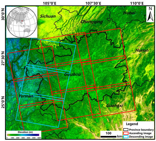
Figure 1.
Location of Guizhou Province and coverage of the SAR datasets. Red and blue rectangles indicate the coverage of ascending and descending Sentinel-1 SAR data, respectively.
The stratigraphy of Guizhou is well developed and mainly belongs to the Yangtze stratum. Sedimentary rocks are the most widely distributed, mainly as limestone and dolomite or as clastic rocks. Carbonate rocks are the main material in the study area, mainly including continuous limestone, the interlayer between limestone and clastic rocks, continuous dolomite, and the interlayer between dolomite and clastic rocks. A series of tectonic movements since the Late Triassic led to the formation of folded mountains. Therefore, these conditions provide the basis for the formation of landslides.
Guizhou Province has a subtropical warm and humid monsoon climate, with an average annual temperature around 15 °C, ranging from 3 °C to 25 °C. The province has abundant but uneven precipitation. That is, it has more rainfall in the east than in the west and more in the south than in the north. And the precipitation from May to September accounts for 50% to 70% of the total annual precipitation. In the karst regions, precipitation is an important supplement to groundwater, which becomes a key factor in landslide development.
Furthermore, coal seams are widely distributed in Guizhou Province, mainly concentrated in the strata of the Permian Liangshan and Longtan Formation. The rocks are mainly limestone, dolomite and other carbonate rocks, sandstone, and other clastic rocks, with 4–6 layers of thin mud shale and other soft rock. Long-term underground mining activities result in the formation of mined-out areas under the mountains, leading to the development of fissures at the surface of the mountain, increasing destruction of the rock mass, and large gradient deformation. Eventually, large-scale landslides often occur [17,18,19].
3. Data and Methods
3.1. Data
Guizhou Province is associated with karst mountains covered with dense surface vegetation. In order to detect active landslides in this area, the deformation rate over Guizhou Province was obtained using Sentinel-1 SAR images with high temporal resolution. A total of 722 scenes in ascending images were collected from nine different orbits, involving three paths and six frames, as shown in Figure 1. The average date duration was approximately 2.5 years, and most tracks were acquired between January 2018 and April 2020, as shown in Table 1, which are conducive to the identification of potential landslides. We also collected descending Sentinel-1 data covering parts of Guizhou Province, where there were 262 scenes in archived images from three frames covering the western region of Guizhou Province, as shown in Figure 1. Therefore, we used descending data to strengthen the location of detected landslides from ascending orbits within the overlapping area. In addition, a one arc-second Shuttle Radar Topography Mission (SRTM) Digital Elevation Model (DEM) was used for InSAR processing, and for calculating the aspect and slope data for the study area. The resolution of SRTM DEM was 30 m, and the data were acquired in 2000. The geological data were digitized from a printed map. In addition, Google Earth images were combined with InSAR deformation data to detect active landslides.

Table 1.
The information in Sentinel-1 SAR images for Guizhou Province.
3.2. Methods
Figure 2 shows the flowchart for detection and control factor analysis of active landslides in Guizhou Province. Firstly, improved InSAR processing was applied to obtain the surface deformation over Guizhou Province. We processed the multi-orbit SAR data independently, where the same orbit SAR data were processed with multiple patches, which can effectively reduce the atmospheric error [20]. Then, spatial and temporal baseline thresholds were set to generate original interferograms [21]. An adaptive filtering method in γ software 2015 was used to reduce the interferogram phase noise [22]. We filtered each interferogram twice with window sizes of 32 and 16; the exponent and step for filtering were set to 0.4 and 2, respectively. Subsequently, the minimum cost flow (MCF) algorithm was used to unwrap the interferograms [23,24]. The coherence threshold for phase unwrapping was set to 0.3. Thereafter, the optimal unwrapping of interferograms was automatically selected based on coherence, and the original deformation rate and time series were calculated using the ISBAS InSAR method. This method allows the optimal selection of interferometric pairs independently for each pixel, which can increase effectively the number of monitoring points. After removing atmospheric and ramp errors from the original results, residual tropospheric noise, ionospheric noise, and orbital errors were corrected using a spatiotemporal filtering method. The deformation velocity over all of Guizhou Province and the deformation time series of typical landslides were finally obtained.
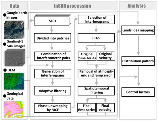
Figure 2.
The flowchart of detection and control factor analysis of active landslides in Guizhou Province.
Secondly, the active landslides were mapped by combining deformation and multi-temporal optical satellite images, where obvious sliding signs were detected. Furthermore, in order to analyse the control factors of landslide distribution, the detected landslide pattern is discussed in terms of topographic and geological data. As for the stratigraphy, we searched the nearest stratigraphic boundary for each landslide and calculated automatically the shortest distance between the landslide location and the stratigraphic boundary. Finally, we used Spearman correlation coefficients to find factors significantly associated with landslide distribution.
3.2.1. ISBAS-InSAR
In order to increase the density of monitoring points, the ISBAS-InSAR method was applied to calculate the deformation rate and time series. Unlike in the traditional SBAS-InSAR method, in the ISBAS-InSAR method, the deformation time series is obtained using a fixed combination of interferograms at each pixel, and if one of the selected unwrapping interferograms fails to have an effect value due to low coherence, the pixel is discarded. We addressed this problem effectively using ISBAS-InSAR [25,26]. Firstly, we set the thresholds of coherence and minimum number of selected interferograms. For each pixel, if the coherence of an interferometric pair exceeded the coherence threshold, it was selected to calculate the deformation time series; moreover, when the number of selected interferograms exceeded the threshold, the deformation time series at the pixel was acquired; otherwise, it was discarded. Secondly, when the interferograms were selected, the deformation rate between every two neighbouring dates was calculated, and finally, the deformation time series was readily obtained by integrating each deformation rate in the time domain [27].
3.2.2. Temporal and Spatial Filtering
There still existed some atmospheric delays and ramp errors in the original deformation time series and velocity that could not be removed effectively by using traditional methods. Therefore, a spatiotemporal filtering approach was adopted [28,29]. The time series results were filtered by a high pass in the time domain and a low pass in the spatial domain using one- and two-dimensional Gaussian kernels, respectively. Furthermore, the short temporal filter width was used for Sentinel-1 to preserve the real nonlinear deformation of the landslide.
4. Results
4.1. Error Correction and Monitoring Point Improvement
Firstly, as shown in Figure 3a, although the atmospheric error was corrected with a linear model between the residual phase and the elevation, there still existed residual atmospheric errors, which would destroy the deformation result and misinform the landslide identification. But in Figure 3b, the residual atmospheric phase is well decreased using the spatiotemporal filtering method, which benefitted landslide detection. Further, to overcome the sparse monitoring points caused by the decorrelation over vegetation regions shown in Figure 3c using the traditional SBAS method, the ISBAS method was used to obtain dense monitoring points, especially in the high deformation area shown in Figure 3d, where complete landslide boundaries can be well mapped. In addition, the processing times of the experiments shown in Figure 3c,d were 3.6 and 1.7 s, respectively. The experiments were performed based on the Ubuntu 16.04 system with an Intel(R) Xeon(R) CPU E5-2630 v4 on a 2.20-GHz computer, which was manufactured by Dell.
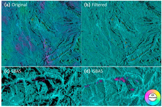
Figure 3.
The comparison between deformation results acquired using the traditional SBAS method, spatiotemporal filtering, and the ISBAS method. (a) The original deformation rate after correcting for atmospheric and ramp errors. (b) The deformation rate after spatiotemporal filtering. (c,d) The deformation rates obtained using the SBAS and ISBAS methods, respectively.
4.2. InSAR Deformation Rates for Guizhou Province
The LOS deformation rates for Guizhou Province were obtained from the ascending and descending Sentinel-1 SAR images shown in Figure 4, where positive values indicated that the surface was close to the satellite and negative values showed that it moved away from the satellite. Firstly, overall, it is clear in Figure 4a that the ascending results covered all of Guizhou Province, with a total area of approximately 1.76 × 10⁵ km2, while the descending results in Figure 4b covered only the western area of Guizhou. The ISBAS-InSAR method can increase the point density of the InSAR deformation effectively. For the ascending results, a total of 5.892 × 10⁸ InSAR monitoring points were acquired across Guizhou Province. The average density of efficient points was about 3.348 × 10³ per square kilometre. Regarding the descending results, the number of InSAR monitoring points was 1.993 × 10⁸, and the average density was 3.517 × 10³ per square kilometre. Further, three typical areas were selected to demonstrate the ascending and descending deformation rate clearly, as shown in Figure 4c–h. It can be seen that the locations where deformation existed in the ascending and descending results were essentially the same. Furthermore, the different deformation patterns between the ascending and descending results were due to the different SAR geometry and local topography. Therefore, the combination of the two orbits in the overlapping area ensured more accurate detection of landslide locations.
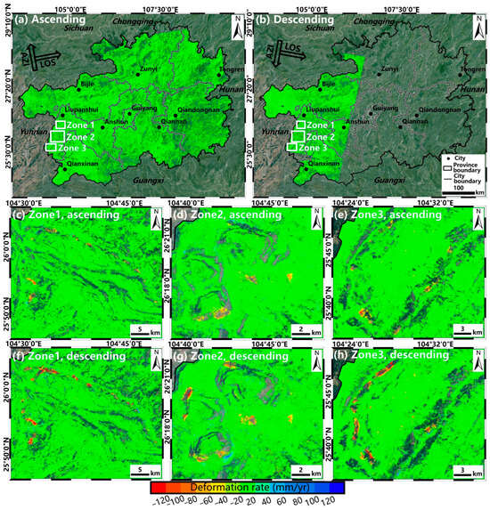
Figure 4.
The deformation rate maps for Guizhou Province obtained using ascending and descending Sentinel-1 images. (a,b) The ascending and descending LOS deformation rates for Guizhou Province. (c–h) are ascending and descending results from three typical active landslide zones, respectively, which are shown in (a,b).
4.3. The Distribution of Active Landslides in Guizhou
As only partial areas were monitored by descending SAR images, we used the ascending deformation rate to identify the landslides shown in Figure 4a. The active landslides were detected by combining the deformation rate and Google Earth optical images. Specifically, since there are so many underground mining zones in Guizhou, which result in large amounts of surface subsidence, they were discarded based on topography and signs of surface deformation. Therefore, a total of 693 active landslides were detected, and their distribution is shown in Figure 5. It can be seen that active landslides were mainly concentrated in the western and northern parts of Guizhou Province [15]. The numbers of landslides detected in each city were as follows: 148 in Liupanshui City, 139 in Bijie City, 82 in Zunyi City, 76 in Qianxinan City, 66 in Qiannan City, 58 in Tongren City, 51 in Qiandongnan City, 48 in Guiyang City, and 25 in Anshun City. Moreover, the large-scale active landslides were mainly located in the cities of Liupanshui and Bijie, where intensive mining activities took place for a long time.
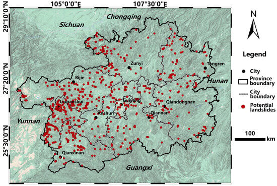
Figure 5.
The distribution of the detected active landslides.
In addition, five typical landslides were selected for verification and are shown in Figure 6, where obvious signs of collapse on the surface and visible mining plants at the foot of the slopes can be seen, indicating the mining-induced landslides. Moreover, significant deformation can be seen in both the ascending and descending InSAR results, among which, the Baiyan landslide, shown in Figure 6(a1) occurred on 8 May 2022, resulting in the death of three people [30].
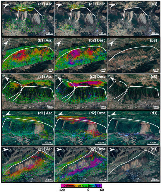
Figure 6.
The ascending and descending deformation rate maps and optical images for five typical landslides illustrated in Figure 5. ((a–e)1) the ascending deformation rate, ((a–e)2) the descending deformation rate, ((a–e)3) the optical images. The white solid lines are landslide boundaries. The optical images are from Google Earth.
4.4. Distribution Pattern of the Active Landslides in Terms of Topographic Factors
To explore the control factors of the detected active landslides, the distribution pattern of the landslides in terms of topographic factors was analysed including the elevation, aspect, and slope. Firstly, the relationship between the landslide distribution and elevation is shown in Figure 7a, where the intensive distribution area of landslides is mainly concentrated in the western part of Guizhou, and the altitude of this area is high and the terrain fluctuates greatly. In Figure 7d, we can see that the number of landslides increases with the elevation and that the landslides are mainly distributed between 900 m and 1900 m. Secondly, the relationship between landslide distribution and the aspect of the terrain is shown in Figure 7b. Quantitatively, Figure 7e shows that 202 landslides occurred between 112.5° and 202.5°. Finally, the relationship between landslide distribution and slope is shown in Figure 7c,f. Most landslides are located on the slopes between 10° and 30°, which are mainly due to the local karst topography and the SAR incidence angle.
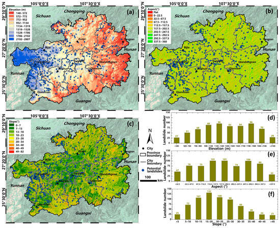
Figure 7.
The distribution pattern of the active landslides in terms of topographic factors. (a–c) The distribution of active landslides overlying an elevation, aspect, and slope map, respectively. (d–f) The histograms of landslide number in terms of elevation, aspect, and slope, respectively.
5. Discussion
5.1. Distribution Pattern of the Active Landslides in Terms of Geological Factors
In order to reveal the control factors of karst landslides, we illustrated the relationship between active landslides and stratigraphic lithology in Guizhou Province in Figure 8, where we can notice that the landslides are mainly concentrated on several typical strata, including the triassic system, lower series, feixianguan formation, silty mudstone, and mudstone, the permian system, upper series, xuanwei group, longtan and dalong formation, sandstone, siltstone, marl, and coal, and the triassic system, middle series, guanling formation, dolomite, limestone, and marlstone.
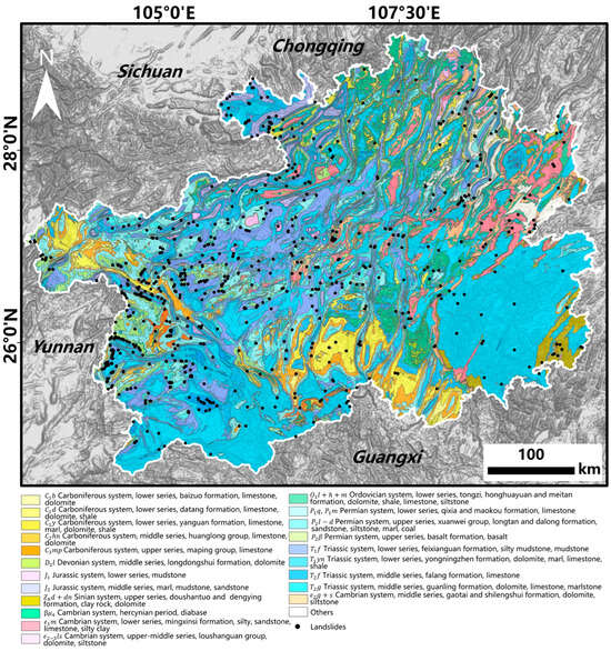
Figure 8.
The relationship between the active landslides and stratigraphic lithology.
Moreover, we can see that most landslides are concentrated on the boundary of two specific neighbouring strata, especially in the western and northern Guizhou Province. In order to further reveal the formation of landslides in karst mountains, the distribution of landslides for each stratigraphic combination is statistically analysed. Firstly, the landsides in each stratum combination are detected. Then, in each stratum combination, the shortest distance from two neighbouring stratum boundaries to each landslide is calculated. Next, the counting and drawing of the landslide number in each stratum are performed. To this end, we illustrate landslides belonging to 29 stratigraphic combinations in Figure 9, where each column represents one adjacent stratigraphic combination, with stratigraphic names labelled on two ends, the centre is the stratigraphic boundary, the size of the cycle indicates the number of landslides, and the position of the circle indicates the distance away from a stratigraphic boundary. It can be clearly seen in Figure 9 that most landslides are mainly concentrated in the three left stratigraphic combinations, that is , , and . Moreover, the closer to the stratigraphic boundary, the more landslides are distributed, which indicated that a special stratigraphic combination and stratigraphic boundary control the formation of active landslides in Guizhou Province.
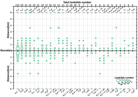
Figure 9.
The relationship between active landslides and stratigraphic combinations. The size of the circle represents the landslide number, and the location of the circle represents the distance from the landslide to the stratigraphic boundary.
As we can see in Figure 9, the greatest number of landslides occurred between strata and . We selected a typical landslide-prone area in Figure 10 to analyse their geomorphological and lithological characteristics, where the ascending and descending InSAR deformation rates and stratigraphic lithology are shown in Figure 10a,b, respectively. The strata from high to low elevation are , , and , respectively. Firstly, both ascending and descending results can be used to detect landslides with similar deformation patterns. Secondly, the detected landslides mainly occurred near the boundary of and , where the surface of landslide-prone areas experienced obvious avalanches and slides according to the optical images. This example thoroughly illustrates the spatial relationship between landslides and typical stratigraphic lithology.
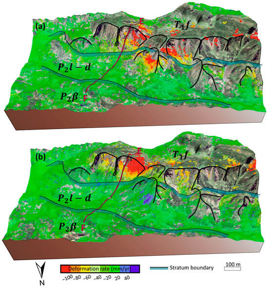
Figure 10.
The InSAR deformation and stratigraphic lithology for a typical landslide-prone area in Guizhou Province. (a) The ascending deformation rate, and (b) the descending deformation rate.
5.2. The Key Control Factors of Landslide Distribution
We explored the correlation between the landslide density and elevation, slope, aspect, and the distance to the boundary to reveal the key control factors of landslide distribution. Firstly, the landslide density in the Guizhou area was calculated based on 693 detected landslides. Then, Spearman correlation coefficients between the landslide density and each of four factors were calculated, as shown in Figure 11a, where the significance level was 0.05. Spearman correlation coefficients can be used to measure correlations, including nonlinear correlations, which can take a value between +1 and −1; the closer the value is to 0, the weaker the association between the two variables, whereas the closer the value is to the ±1, the stronger the monotonic relationship. The magnitude of the correlation coefficients for elevation and distance to the stratigraphic boundary were much greater than that of the slope and aspect; therefore, Figure 11a shows that the landslide density is significantly correlated with elevation and distance to the stratigraphic boundary. The correlation coefficient for elevation is 0.54, which indicates that the higher the elevation is, the greater the number of landslides that are distributed. This fact can also be seen in Figure 11b. The correlation coefficient of distance is −0.19, which means that landslides are more possibly distributed in an area near a neighbouring stratigraphic boundary; this relationship can also be observed in Figure 11c. Therefore, the landslides in Guizhou Province are mainly controlled by the combination of elevation and specific strata.
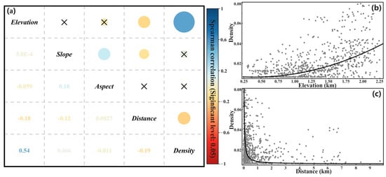
Figure 11.
The correlation analysis between the landslide density and control factors. (a) Spearman correlation coefficients between the landslide density and elevation, distance to the stratum boundary, slope, and aspect, respectively, where the significance level is 0.05. The size of the circle indicates the magnitude of the correlation coefficient, the cross sign indicates non-significant correlation. (b,c) The relationships between the detected landslide density and elevation and the distance to the stratum boundary.
5.3. Verification of Key Landslide Control Factors
To further illustrate two control factors on landslide development, we focussed on one typical landslide and extracted the deformation profile along line EF in Figure 10 from the ascending and descending results, where the topography and three stratigraphic lithologies are superimposed. Figure 12 is the InSAR deformation rate and geological setting along the profile, where the InSAR deformation along the profile can be divided into two sections, including the deformation and stable sections, and the lithology from high elevation to low are mudstone in , sandstone in , and lava rock in , respectively, corresponding to a hardness from soft to hard. The topography is extremely steep at high elevation and relatively slow at low elevation. From Figure 12, surface deformation mainly happened at a higher elevation with a mudstone and sandstone stratigraphic combination, which is more susceptible to landslide formation.
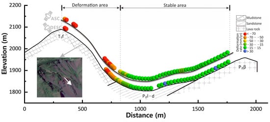
Figure 12.
The InSAR deformation rate and geological setting for the profile of a typical landslide area. The deformation rates both for ascending and descending, topographical, and geological setting along profile EF in Figure 10; the coloured spheres represent the InSAR deformation rate.
6. Conclusions
In this study, ascending and descending Sentinel-1 images are applied to detect active landslides and reveal their key control factors in Guizhou Province, China. The spatiotemporal filtering and ISBAS method improve the InSAR deformation precision and monitoring density. A total of 693 active landslides are detected by combining InSAR deformation, topographic data, and optical images. The detected landslides are mainly distributed in the area with an elevation of 900–1900 m, an aspect of 112.5–292.5°, a slope of 10–30°, and three strata, namely, , , and . Further, more landslides occurred close to the boundary of the three stratigraphic combinations, that is, , , and . It is revealed that the landslide distribution in Guizhou Province is mainly controlled by elevation and distance to the stratigraphic boundary. One typical landslide verifies that it mainly occurred at a high elevation with a steeper slope and soft stratum. This study provides a new perspective for landslide detection in karst mountain regions in terms of InSAR deformation, elevation, and stratigraphy.
Author Contributions
Conceptualization, C.Z. and L.C.; methodology, L.C. and Y.K.; software, H.C.; validation, L.C. and H.C.; formal analysis, X.L.; investigation, C.Z., L.C. and H.C.; resources, C.Z.; data curation, L.C.; writing—original draft preparation, L.C.; writing—review and editing, C.Z.; visualization, L.C.; supervision, C.Z. and H.C.; project administration, B.L.; funding acquisition, C.Z. and B.L. All authors have read and agreed to the published version of the manuscript.
Funding
This work was funded by the Natural Science Foundation of China (Grant No. 41929001), the National Key R&D Program of China (No. 2022YFC3004302), and the Fundamental Research Foundation of the Central Universities (No. 300203211262).
Data Availability Statement
Data are available from the corresponding author upon reasonable request.
Acknowledgments
This study was supported by the High-Performance Computing Platform of Chang’an University. We would like to thank the European Space Agency for providing the Sentinel-1A/B SAR data free of charge.
Conflicts of Interest
The authors declare no conflict of interest.
References
- Feng, Z.; Li, B.; Yin, Y.; He, K. Rockslides on limestone cliffs with subhorizontal bedding in the southwestern calcareous area of China. Nat. Hazards Earth Syst. Sci. 2014, 14, 2627–2635. [Google Scholar] [CrossRef]
- Cui, F.; Li, B.; Xiong, C.; Yang, Z.; Peng, J.; Li, J.; Li, H. Dynamic triggering mechanism of the Pusa mining-induced landslide in Nayong County, Guizhou Province, China. Geomat. Nat. Hazards Risk 2022, 13, 123–147. [Google Scholar] [CrossRef]
- Li, J.; Li, B.; He, K.; Gao, Y.; Wan, J.; Wu, W.; Zhang, H. Failure mechanism analysis of mining-induced landslide based on geophysical investigation and numerical modelling using distinct element method. Remote Sens. 2022, 14, 6071. [Google Scholar] [CrossRef]
- Chen, L.; Zhao, C.; Li, B.; He, K.; Ren, C.; Liu, X.; Liu, D. Deformation monitoring and failure mode research of mining-induced Jianshanying landslide in karst mountain area, China with ALOS/PALSAR-2 images. Landslides 2021, 18, 2739–2750. [Google Scholar] [CrossRef]
- Liu, X.; Zhao, C.; Zhang, Q.; Lu, Z.; Li, Z.; Yang, C.; Zhu, W.; Liu-Zeng, J.; Chen, L.; Liu, C. Integration of Sentinel-1 and ALOS/PALSAR-2 SAR datasets for mapping active landslides along the Jinsha River corridor, China. Eng. Geol. 2021, 284, 106033. [Google Scholar] [CrossRef]
- Costantini, M.; Ferretti, A.; Minati, F.; Falco, S.; Trillo, F.; Colombo, D.; Novali, F.; Malvarosa, F.; Mammone, C.; Vecchioli, F. Analysis of surface deformations over the whole Italian territory by interferometric processing of ERS, Envisat and COSMO-SkyMed radar data. Remote Sens. Environ. 2017, 202, 250–275. [Google Scholar] [CrossRef]
- Wasowski, J.; Bovenga, F. Investigating landslides and unstable slopes with satellite Multi Temporal Interferometry: Current issues and future perspectives. Eng. Geol. 2014, 174, 103–138. [Google Scholar] [CrossRef]
- Sonnessa, A.; di Lernia, A.; Nitti, D.O.; Nutricato, R.; Tarantino, E.; Cotecchia, F. Integration of multi-sensor MTInSAR and ground-based geomatic data for the analysis of non-linear displacements affecting the urban area of Chieuti, Italy. Int. J. Appl. Earth Obs. Geoinf. 2023, 117, 103194. [Google Scholar] [CrossRef]
- Mondini, A.C.; Guzzetti, F.; Chang, K.-T.; Monserrat, O.; Martha, T.R.; Manconi, A. Landslide failures detection and mapping using Synthetic Aperture Radar: Past, present and future. Earth-Sci. Rev. 2021, 216, 103574. [Google Scholar] [CrossRef]
- Pepe, A.; Calò, F. A review of interferometric synthetic aperture RADAR (InSAR) multi-track approaches for the retrieval of Earth’s surface displacements. Appl. Sci. 2017, 7, 1264. [Google Scholar] [CrossRef]
- Bekaert, D.P.; Handwerger, A.L.; Agram, P.; Kirschbaum, D.B. InSAR-based detection method for mapping and monitoring slow-moving landslides in remote regions with steep and mountainous terrain: An application to Nepal. Remote Sens. Environ. 2020, 249, 111983. [Google Scholar] [CrossRef]
- Bouali, E.H.; Oommen, T.; Escobar-Wolf, R. Mapping of slow landslides on the Palos Verdes Peninsula using the California landslide inventory and persistent scatterer interferometry. Landslides 2018, 15, 439–452. [Google Scholar] [CrossRef]
- Zhu, Y.; Yao, X.; Yao, L.; Yao, C. Detection and characterization of active landslides with multisource SAR data and remote sensing in western Guizhou, China. Nat. Hazards 2022, 111, 973–994. [Google Scholar] [CrossRef]
- Shen, C.; Feng, Z.; Xie, C.; Fang, H.; Zhao, B.; Ou, W.; Zhu, Y.; Wang, K.; Li, H.; Bai, H. Refinement of Landslide Susceptibility Map Using Persistent Scatterer Interferometry in Areas of Intense Mining Activities in the Karst Region of Southwest China. Remote Sens. 2019, 11, 2821. [Google Scholar] [CrossRef]
- Yue, X.; Wu, S.; Huang, M.; Gao, J.; Yin, Y.; Feng, A.; Gu, X. Spatial association between landslides and environmental factors over Guizhou Karst Plateau, China. J. Mt. Sci. 2018, 15, 1987–2000. [Google Scholar] [CrossRef]
- Yao, K.; Yang, S.; Wu, S.; Tong, B. Landslide Susceptibility Assessment Considering Spatial Agglomeration and Dispersion Characteristics: A Case Study of Bijie City in Guizhou Province, China. ISPRS Int. J. Geo-Inf. 2022, 11, 269. [Google Scholar] [CrossRef]
- Zhong, Z.; Xu, Y.; Wang, N.; Liu, X.; Gao, G. Environmental characteristics and unified failure mode classification system for mining landslides in the karst mountainous areas of southwestern China. Carbonates Evaporites 2023, 38, 2. [Google Scholar] [CrossRef]
- Chang, M.; Dou, X.; Tang, L.; Xu, H. Risk assessment of multi-disaster in Mining Area of Guizhou, China. Int. J. Disaster Risk Reduct. 2022, 78, 103128. [Google Scholar] [CrossRef]
- Wang, J.; Wang, C.; Xie, C.; Zhang, H.; Tang, Y.; Zhang, Z.; Shen, C. Monitoring of large-scale landslides in Zongling, Guizhou, China, with improved distributed scatterer interferometric SAR time series methods. Landslides 2020, 17, 1777–1795. [Google Scholar] [CrossRef]
- Kang, Y.; Lu, Z.; Zhao, C.; Xu, Y.; Kim, J.-w.; Gallegos, A.J. InSAR monitoring of creeping landslides in mountainous regions: A case study in Eldorado National Forest, California. Remote Sens. Environ. 2021, 258, 112400. [Google Scholar] [CrossRef]
- Berardino, P.; Fornaro, G.; Lanari, R.; Sansosti, E. A new algorithm for surface deformation monitoring based on small baseline differential SAR interferograms. IEEE Trans. Geosci. Remote Sens. 2002, 40, 2375–2383. [Google Scholar] [CrossRef]
- Goldstein, R.M.; Werner, C.L. Radar interferogram filtering for geophysical applications. Geophys. Res. Lett. 1998, 25, 4035–4038. [Google Scholar] [CrossRef]
- Pepe, A.; Lanari, R. On the extension of the minimum cost flow algorithm for phase unwrapping of multitemporal differential SAR interferograms. IEEE Trans. Geosci. Remote Sens. 2006, 44, 2374–2383. [Google Scholar] [CrossRef]
- Costantini, M. A novel phase unwrapping method based on network programming. IEEE Trans. Geosci. Remote Sens. 1998, 36, 813–821. [Google Scholar] [CrossRef]
- Bateson, L.; Cigna, F.; Boon, D.; Sowter, A. The application of the Intermittent SBAS (ISBAS) InSAR method to the South Wales Coalfield, UK. Int. J. Appl. Earth Obs. Geoinf. 2015, 34, 249–257. [Google Scholar] [CrossRef]
- Sowter, A.; Bateson, L.; Strange, P.; Ambrose, K.; Syafiudin, M.F. DInSAR estimation of land motion using intermittent coherence with application to the South Derbyshire and Leicestershire coalfields. Remote Sens. Lett. 2013, 4, 979–987. [Google Scholar] [CrossRef]
- Schmidt, D.A.; Bürgmann, R. Time-dependent land uplift and subsidence in the Santa Clara valley, California, from a large interferometric synthetic aperture radar data set. J. Geophys. Res. Solid Earth 2003, 108, 1–13. [Google Scholar] [CrossRef]
- Morishita, Y.; Lazecky, M.; Wright, T.J.; Weiss, J.R.; Elliott, J.R.; Hooper, A. LiCSBAS: An open-source InSAR time series analysis package integrated with the LiCSAR automated Sentinel-1 InSAR processor. Remote Sens. 2020, 12, 424. [Google Scholar] [CrossRef]
- Hooper, A.; Segall, P.; Zebker, H. Persistent scatterer interferometric synthetic aperture radar for crustal deformation analysis, with application to Volcán Alcedo, Galápagos. J. Geophys. Res. Solid Earth 2007, 112, 1–21. [Google Scholar] [CrossRef]
- Li, B.; Zhao, C.; Li, J.; Chen, H.; Gao, Y.; Cui, F.; Wan, J. Mechanism of mining-induced landslides in the karst mountains of Southwestern China: A case study of the Baiyan landslide in Guizhou. Landslides 2023, 20, 1481–1495. [Google Scholar] [CrossRef]
Disclaimer/Publisher’s Note: The statements, opinions and data contained in all publications are solely those of the individual author(s) and contributor(s) and not of MDPI and/or the editor(s). MDPI and/or the editor(s) disclaim responsibility for any injury to people or property resulting from any ideas, methods, instructions or products referred to in the content. |
© 2023 by the authors. Licensee MDPI, Basel, Switzerland. This article is an open access article distributed under the terms and conditions of the Creative Commons Attribution (CC BY) license (https://creativecommons.org/licenses/by/4.0/).