1. Introduction
Geographic Information System (GIS) refers to a field of science that involves the study of the lands, features, inhabitants, and phenomena of the Earth. GIS is a comprehensive framework that includes the processes of acquiring, retaining, modifying, examining, and presenting geographical data in an effective and streamlined way [
1]. The software package under consideration may be described as a tool that effectively establishes a connection between graphical information and attribute data recorded in a database, and vice versa [
2,
3]. GIS provides a range of tools that may enhance operational efficiency and effectiveness in handling both spatial and non-spatial characteristic data [
4,
5].
The integration of drones with advanced technologies such as artificial intelligence (AI), machine learning (ML), cutting-edge equipment including high-definition (HD) cameras, precision lenses, light detection and ranging (LiDAR), and the computational efficiency afforded by cloud storage and computing has witnessed exponential growth across diverse domains. Accordingly, GIS has revolutionized the field of data collection and analysis. Drones help to procure high-resolution images and collect a plethora of data. GIS, on the other hand, is a technology that captures, manages, analyzes, and displays spatial or geographic data [
6]. A simple pictorial representation highlighting the different functions of drones and GIS as well as their potential integrated applications is shown in
Figure 1. The integration of these two technologies has brought numerous benefits, especially in areas such as mapping, surveying [
7], disaster management [
8], and agriculture [
9].
1.1. Incorporation of GIS–Drone Technology
Drones equipped with high-resolution cameras can capture detailed images of the terrain and produce accurate maps of an area. These maps can be used in urban planning, land-use management, and environmental monitoring [
10]. Surveyors can also use drones to capture topographic data and produce digital elevation models (DEMs) that are useful in various fields such as civil engineering and mining [
11,
12]. Another important application of GIS-integrated drone technology is disaster management and emergency response assistance [
8]. Drones equipped with thermal cameras can be used to detect and monitor wildfires and other natural disasters [
13]. Drones can also be used to assess the damage caused by disasters and identify areas that need immediate attention [
14]. GIS can be used to analyze the data collected by drones and produce maps that show the extent of the damage and the areas that need assistance.
1.2. Use Cases and Applicative Scope
In agriculture, drones integrated with GIS can be used to monitor crop growth and health [
15]. Drones can capture multispectral images of crops, which can be used to detect the early signs of disease or stress. GIS can then be used to analyze data and produce maps that show the areas that need attention. This can help farmers take timely action and improve their yields [
16,
17]. Apart from these applications, drone-integrated GIS can also be used in wildlife monitoring, infrastructure inspection, and search and rescue operations. In wildlife monitoring, drones can be used to capture images of animals and track their movement [
18,
19]. In infrastructure inspection, drones can be used to inspect bridges, power lines, and other structures that are difficult to access [
20,
21]. In search and rescue operations, drones can be used to search for missing persons or to locate stranded individuals [
22,
23].
Furthermore, drones integrated with GIS can play a crucial role in smart city management and sustainable development [
24,
25]. GIS is a technology that captures, manages, analyzes, and presents geographical data in a way that helps decision-makers make informed choices. By integrating drones with GIS, city managers can collect and analyze data on various aspects of the city such as traffic management [
26], public safety [
27], and environmental monitoring [
28]. Drones integrated with GIS have the ability to map and monitor changes in urban landscapes [
29]. By capturing aerial imagery and analyzing it using GIS, city planners can track changes in land use, detect illegal construction, and identify areas in need of development. This information can be used to develop more sustainable urban planning strategies that promote environmentally friendly and socially equitable growth [
30]. A generalized flowchart for the implementation of GIS–drone technology is depicted in
Figure 2 [
31].
1.3. Motivation
Numerous review and research articles have been presented related to drones and GIS [
32,
33,
34,
35,
36]. This review aims to present the multi-faced applicative potential of GIS–drones through presenting a comprehensively exhaustive review of their many applications achieved, their processes, and innovations while highlighting their collective major challenges. The motivation of this review are as follows:
To help understand the utilization of drones towards complementing and augmenting data acquisition, and their implementation towards geographical and geospatial analysis.
To review multiple sectors, including agriculture, smart cities, advanced supply chain management, mapping, monitoring, surveillance, and tracking while highlighting their respective use-cases to visualize a comprehensive scope of GIS–drone technology.
To facilitate a resource for students, academics, researchers, and legislators to access the latest developments in this field and progress towards necessary standardization and innovation.
1.4. Paper Organization
The organization of this article is as follows.
Section 2 includes a brief background on the evolution of GIS technology.
Section 4 presents the technological advancement associated with precision farming.
Section 5 defines the use case of GIS drones in the development of resilient smart cities.
Section 6 presents the utilization of combined GIS–drone technology in the formulation of the smart supply chain industry, outlining its enhancement in the health sector, disaster management, and delivery services. The enhancement of security surveillance, wildlife and forest monitoring, military applications, and oil and gas pipeline monitoring through GIS–drone applications through mapping, tracking, and monitoring is discussed in
Section 7.
Section 8 includes various challenges related to GIS–drone technology, followed by the conclusion in
Section 10.
2. Background
As a powerful tool, GIS technology has a wide range of applications in various fields, including urban planning, environmental management, health, agriculture, transportation, and emergency response. Although GIS was traditionally used for spatial data analysis and visualization for several decades, with evolving technologies, GIS has also evolved and has significantly contributed to different fields and applications. For example, the integration of remote sensing technology with GIS in the 1980s and 1990s was a significant milestone in the evolution of GIS technology. Remote sensing technology uses satellite imagery to collect data on the Earth’s surface. These data are then integrated into GIS systems to create detailed maps of the environment. This integration allowed for the creation of more accurate and comprehensive maps, which were used for a wide range of applications, including environmental monitoring, land-use planning, and natural resource management [
6,
30].
Another breakthrough integration was that of global positioning systems (GPSs) and GIS. GPS technology uses satellite signals to determine the location of objects on the Earth’s surface. The integration of GPS technology with GIS allowed for the creation of real-time maps that could track the movement of objects, including vehicles, people, and animals. The GIS and GPS integration revolutionized the transport and logistics industry [
37]. One of the earliest applications of GIS and GPS integration was in the field of wildlife tracking [
38]. Researchers used GPS technology to track the movement of animals and GIS technology to analyze the spatial data collected. This helped to understand the behavior and movement patterns of animals and inform wildlife conservation efforts [
39,
40]. The recent development in GIS technology integrated with mobile devices such as smartphones and tablets has further revolutionized GIS applications. Computing devices allow us to collect spatial data in the field and transmit these to a central database for analysis. For example, in the field of emergency response, mobile devices equipped with GIS technology allow emergency responders to collect real-time data on the location and extent of emergencies, which is then transmitted to a central database for analysis. This helps inform emergency response efforts and improve response times [
41].
An interesting cross-pollination of GIS is drone technology. The technology of drones has evolved over time with numerous upgrades, installations, and optimizations increasing its potential as well as application in numerous different studies [
42,
43,
44,
45]. Drones or unmanned aerial vehicles (UAVs) have revolutionized the field of GIS by providing high-resolution, accurate, and up-to-date imagery data that can be used for a variety of GIS applications [
46]. Initially, drones were used for aerial photography and videography, but with the introduction of specialized sensors such as LiDAR and hyperspectral cameras, drones can now collect data on vegetation health, topography, and water quality [
47]. These sensors can provide highly accurate and detailed data that can be used for a variety of GIS applications, including precision agriculture, land-use planning, and natural resource management. The integration of drone technology with GIS has also become more streamlined, with the development of software and platforms that can process and analyze drone-collected data. This has made it easier for GIS professionals to incorporate drone data into their existing GIS workflows and analysis [
12,
48].
The use of drones in GIS applications is on the rise and is a popular topic for future research. The global GIS–drone mapping market is expected to reach a valuation of USD 349.5 million in 2023 and is projected to grow at a compound annual growth rate of 16.5 %, reaching up to USD 1609.6 million in the next ten years [
49]. Therefore, in this paper, we present an insightful review of the integration of drone technology with GIS in different fields of study.
3. Integration of Drone with GIS Technique—Use Cases
Drone-integrated GIS is a rapidly evolving technology that combines the capabilities of drones with GIS software to generate spatial data and maps for various sectors. This technology has proved to be a game-changer in various industries, including agriculture, health, disaster management, security and surveillance, wildlife monitoring, delivery services, and military applications. In the following section, the drone-integrated GIS application for various fields is comprehensively discussed, as shown in
Figure 3.
4. Precision Farming
In the agricultural sector, drone-integrated GIS has revolutionized farming practices by enabling farmers to identify crop diseases, monitor crop growth, and optimize water usage. Drones equipped with multispectral cameras can capture high-resolution images of crops, which can be used to identify areas that require attention, such as irrigation and fertilization. This information is then processed by GIS software to generate accurate maps, allowing farmers to make informed decisions and maximize yields.
A detailed survey on UAV application in precision agriculture (PA) was performed in [
41]. The author explicitly addressed the different GIS applications in PA. PA applications rely on numerical data that describe specific parameters, field observations, and agrochemical quantities, along with geolocation data from GPS systems, to create production maps. Due to the vast amount of data, appropriate software, such as ArcGIS, is necessary to process, organize, analyze, and visualize the information as digital maps [
12,
46,
48,
50]. These systems can also include statistical analyses, simulation data, and information extracted from various databases to support decision making [
51]. A GIS generally comprises several components, including a spatial data input system that integrates various types of data such as maps, satellite imagery, and multi-spectral imagery. Additionally, this includes a data storage system to store the collected information. Furthermore, a data visualization system is employed to present the data in the form of maps, tables, and shapes. Moreover, a data analysis system is utilized to identify and rectify potential data errors, as well as analyze geospatial data. Lastly, a user interface system is implemented to facilitate user interaction with the GIS system [
52]. An illustrative image showing PA using the quasi zenith satellite system [
53] by Hitachi is shown in
Figure 4.
Drone-integrated GIS applications in agriculture offer numerous benefits, such as:
Improved crop monitoring: Drones can capture high-resolution images of crop fields and use GIS to create accurate maps of crop health, density, and yield potential. This helps farmers monitor crop growth and identify any potential issues early on.
Precision farming: Drone-integrated GIS applications allow farmers to apply fertilizers, pesticides, and other inputs precisely where they are needed, reducing costs and improving crop yield.
Time and cost savings: Drones can cover large areas of farmland in a short amount of time, allowing farmers to identify potential issues quickly and efficiently, saving time and reducing costs.
Enhanced data collection and analysis: GIS technology can be used to collect and analyze data from drones, weather stations, and other sensors to provide insights into soil health, weather patterns, and crop performance.
Better decision making: By providing real-time data and imagery, drone-integrated GIS applications can help farmers make more informed decisions about irrigation, fertilization, and other management practices.
Increased safety: Drones can be used to monitor farmland and identify potential safety hazards, such as areas with poor drainage or uneven terrain.
Reduced environmental impact: By providing more accurate data and analysis, drone-integrated GIS applications can help farmers reduce their use of fertilizers, pesticides, and other chemicals, leading to a reduction in environmental impact.
A summary table with some recent research work performed on drone-integrated GIS applications in the field of agriculture is presented in
Table 1.
5. Resilient Smart City
5.1. Optimal Site Selection and Asset Deployment
GIS and drones have revolutionized the process of optimal site selection and asset deployment such as finding the best region for harnessing solar or wind energy farms [
58] or the implementation of smart grids [
59]. By integrating GIS data with drone technology, governments and agencies can collect real-time geospatial data, enabling them to make informed decisions. In site selection, GIS aids in identifying suitable locations based on factors like accessibility, proximity to resources, and environmental impact. Drones play a crucial role in this process by capturing high-resolution aerial imagery and surveying terrains, offering unparalleled insights. In particular, for the optimal site selection for the development of solar and wind energy farms, GIS enables the analysis of vast datasets, such as terrain, solar irradiance, wind patterns, and environmental constraints, to identify the most suitable locations for renewable energy installations. By integrating drone imagery into GIS, detailed and up-to-date aerial views of potential sites can be obtained, allowing for accurate topographical assessments and the identification of obstacles. This combination facilitates informed decision making, reducing development risks and maximizing energy output. The synergy between GIS and drones streamlines the site selection process, promoting the expansion of sustainable solar and wind energy projects, and contributing to a greener and more efficient energy landscape [
60]. Moreover, in asset deployment, GIS allows for efficient resource allocation by visualizing infrastructure and understanding its interconnectivity. When it comes to smart grids, the combination of GIS and drones assists in monitoring power distribution, analyzing energy consumption patterns, and facilitating maintenance. This seamless integration enhances operational efficiency and promotes sustainable energy management [
61].
5.2. Urban Planning
The integration of drones and GIS has transformed the way urban planning is carried out in many cities around the world. In recent years, drones have become increasingly popular due to their ability to capture high-resolution aerial imagery and collect data in a non-invasive and cost-effective manner. This technology has allowed urban planners to better understand the dynamics of built environments, identify key areas of concern, and make informed decisions about land use and development [
62]. Drones provide high-resolution aerial imagery for urban planning, allowing planners to analyze building footprints, road networks, and land use patterns with GIS software to identify areas for improvement. Additionally, drone-integrated GIS technology enables non-invasive and cost-effective data collection on air quality, noise pollution, and pedestrian flow to create detailed maps for identifying areas of concern and prioritizing interventions [
63,
64].
Drone-integrated GIS technology has been used in a number of urban planning projects around the world. A route planning technique for multi-UAV cooperative data collection for 3D building model reconstruction in response to emergencies was presented in [
65]. In Singapore, drones were used to collect data on the condition of the city’s green spaces, which was then analyzed using GIS software to identify areas where improvements were needed [
66]. In Kota Bharu, multi-rotor drones were used to create 3D models of the city for the purpose of studying urban development and conserving the city heritage [
67].
There are several benefits of using drone-integrated Geographic Information System (GIS) applications for urban planning:
Accurate and detailed data collection: Drones equipped with high-resolution cameras and sensors can capture the accurate and detailed data of urban areas, which can be used to create accurate GIS maps. These data can help urban planners make informed decisions about land use, transportation, and infrastructure development.
Improved efficiency and cost savings: drone technology can significantly reduce the time and cost involved in collecting data for GIS applications. With drones, data can be collected faster and more efficiently than with traditional surveying methods, resulting in cost savings for urban planning projects.
Enhanced data visualization: drone imagery can be integrated with GIS applications to provide the 3D visualizations of urban areas. This can help urban planners better understand the spatial relationships between different features and infrastructure and make more informed decisions about urban planning.
Improved public participation: Drone imagery and GIS applications can be used to engage the public in urban planning processes. By providing detailed visualizations of proposed developments and infrastructure, the public can better understand the potential impacts of urban planning decisions and provide feedback to planners.
Better disaster response: Drones can be used to quickly assess damage and collect data in the aftermath of natural disasters, providing critical information to aid in disaster response and recovery efforts.
A summary table with some recent research work performed with drone-integrated GIS applications in the field of urban planning is presented in
Table 2.
5.3. Smart City Management
In smart city applications, drone-integrated GIS technology can be used to collect data on various aspects of the city’s infrastructure, such as traffic flow, building density, and energy usage. This information can be fed to the GIS software for different types of smart city management applications [
71]. This information can be used to optimize resource allocation, improve public safety, and enhance the overall quality of life for residents. For example, drones equipped with thermal imaging cameras can be used to detect heat loss from buildings, which can help city planners to identify areas that require insulation or other energy-saving measures [
72]. Drones can also be used to monitor traffic flow, identify congested areas, and optimize traffic signal timings to reduce traffic congestion and improve public transportation [
73]. An graphical representation of smart city management using the integrated GIS-drone technology is shown in
Figure 5.
There are several benefits of using drone-integrated GIS applications for smart city development and management:
Accurate and detailed data collection: Drones equipped with high-resolution cameras and sensors can capture the accurate and detailed data of urban areas, which can be used to create accurate GIS maps. These data can help city planners make informed decisions about infrastructure development, traffic management, and environmental management.
Improved efficiency and cost savings: Drone technology can significantly reduce the time and cost involved in collecting data for smart city development and management. With drones, data can be collected faster and more efficiently than with traditional methods, resulting in cost savings for smart city projects.
Enhanced data visualization: Drone imagery can be integrated with GIS applications to provide 3D visualizations of urban areas. This can help city planners better understand the spatial relationships between different features and infrastructure and make more informed decisions about smart city development.
Improved traffic management: Drones can be used to monitor traffic patterns and identify areas in need of traffic management interventions. This can help reduce traffic congestion and improve the overall efficiency of transportation systems.
Better environmental management: Drones can be used to monitor environmental indicators such as air quality, water quality, and noise levels. This can help city planners to make informed decisions about environmental management and ensure that smart city development is sustainable and environmentally friendly.
A summary table with some recent research work performed on drone-integrated GIS applications in the field of smart city management is presented in
Table 3.
6. Smart Supply Chain
The utilization of GIS–drone technology has the potential to enhance the ever-increasing landscape of supply chain management. The combined technology associated with GIS and drones entails harnessing the power of spatial data analysis and unmanned aerial vehicles to optimize supply chain operations in diverse sectors, such as healthcare, disaster management, and delivery services. By leveraging GIS and drone technology, researchers aim to enhance the efficiency, accuracy, and responsiveness of supply chain processes, thereby revolutionizing the way logistics are managed. This section explores the transformative capabilities of smart supply chains and sheds light on the manifold benefits they bring to these critical areas, paving the way for more effective and agile supply chain management practices (
Figure 6).
6.1. Health
The innovative study conducted by John Snow about the cholera epidemic that occurred in London in 1854 serves as a prominent and well-recognized illustration of the efficacy of mapping and spatial methodologies within the field of public health. Shiode et al. in 2015 [
80] recreated the London cholera outbreak using modern GIS technology. GIS has become increasingly prevalent in the healthcare industry for investigating the influence of distance and non-spatial variables on healthcare accessibility and usage [
81]. The use of GIS enables researchers to understand the complex relationship between the physical environment and healthcare outcomes. However, there are differing methodological perspectives employed when exploring the spatial and temporal patterns of healthcare utilization. For instance, some researchers focus on measuring the accessibility of healthcare services and facilities by analyzing the distance between them and the population they serve. Others explore the spatial distribution of healthcare resources and the utilization patterns of these resources by analyzing demographic and socioeconomic factors, such as income and education level. Furthermore, some researchers examine the temporal patterns of healthcare utilization, such as seasonal variations or changes over time due to policy interventions.
In recent years, drone-integrated GIS technology has been adopted for disease surveillance and control in the healthcare industry. GIS-equipped drones can be used to map and track disease outbreaks and the spread of viruses, including the COVID-19 pandemic. By collecting information on high-risk areas and populations, healthcare professionals can take preventive measures to mitigate the spread of disease. Additionally, drones can deliver vaccines to remote and inaccessible areas, such as rural regions or areas affected by natural disasters, where access to healthcare services is limited. This helps to reduce the spread of diseases and improve the overall health outcomes of these populations. The integration of GIS and drone technology is an innovative approach that is transforming the healthcare industry, enabling more effective disease surveillance and control, and improving healthcare access and utilization in remote and underserved areas.
Faster response times: Drones equipped with medical supplies can be used to quickly respond to medical emergencies in remote or hard-to-reach areas. This can significantly reduce response times, and potentially save lives.
Improved supply chain management: Drone technology can be used to monitor the supply chain of medical equipment and supplies, ensuring that they are delivered to the right place at the right time. This can help to reduce waste, optimize inventory levels, and improve the overall efficiency of healthcare supply chains.
Enhanced data visualization: Drone imagery can be integrated with GIS applications to provide detailed visualizations of healthcare facilities and infrastructure. This can help healthcare managers to better understand the spatial relationships between different facilities and make more informed decisions about healthcare management.
Improved disease surveillance: Drones can be used to collect data on disease outbreaks and monitor the spread of infectious diseases. This can help healthcare managers to better understand the patterns of disease transmission and develop effective response strategies.
Better disaster response: Drones can be used to quickly assess damage and collect data in the aftermath of natural disasters, providing critical information to aid in disaster response and recovery efforts. This can help ensure that medical resources are deployed where they are needed most.
A summary table with some recent research work performed with drone-integrated GIS applications in the field of healthcare management is presented in
Table 4.
6.2. Disaster Management
Drones have been widely used in disaster management for rescue operations, emergency delivery, and monitoring the extent of damage. A detailed review of drone applications in the field of disaster management is presented in [
87]. Drones coupled with GIS software will be an amalgamation of two powerful tools that can allow swift action based on accurate and precise location. Drones can be used to assess the extent of damage caused by natural disasters such as hurricanes, earthquakes, and floods. The integration of drones and GIS technology provides a comprehensive platform for capturing, analyzing, and visualizing data in real time. Drones can be equipped with sensors and cameras that capture data and transmit these to the GIS system, where they are analyzed and visualized in real time. GIS technology can provide a spatial analysis of the data captured by drones, which can help disaster management agencies in decision making. Spatial analysis can help in identifying the affected areas, the extent of the damage, and the resources required for relief operations. For example, during a flood, drones can be used to capture the images of the affected areas, which can be analyzed by the GIS system to identify the extent of the damage and the areas that require immediate relief. The drone-integrated GIS application provides several benefits in disaster management, some of which are as follows:
Real-time data: Drones equipped with GIS technology can provide real-time data that can help disaster management agencies in decision-making. Real-time data can help in identifying the affected areas and the resources required for relief operations.
Accurate data: Drones equipped with sensors and cameras can capture accurate data, which can help in identifying the extent of the damage and the areas that require immediate relief.
Cost-effective: The use of drones equipped with GIS technology is cost-effective compared to traditional methods of data collection and analysis.
Time-saving: Drones equipped with GIS technology can capture data in a short period, which can help in decision making and relief operations.
Improved safety: The use of drones equipped with GIS technology can improve safety during relief operations, as they can capture data from a safe distance.
A summary table with some recent research work performed with drone-integrated GIS applications in the field of disaster management is presented in
Table 5.
6.3. Delivery Services
Delivery services have also embraced drone-integrated GIS technology. Drones equipped with GPS technology can be used to deliver packages quickly and efficiently, reducing delivery times and costs. GIS technology allows users to collect, analyze, and visualize geographic data, while drones offer the ability to navigate through difficult terrain and areas with limited accessibility.
Research has shown that drone-integrated GIS applications have the potential to significantly reduce delivery times and costs. In a survey study conducted in [
93], the use of drones for delivery has shown considerable economic and environmental implications. Specifically, the implementation of drone-assisted delivery has resulted in a reduction in carbon emissions by 24.90%, a decrease in overall cost by 22.13%, and a reduction in delivery time by 20.65% when compared to conventional delivery methods. Furthermore, GIS technology can be used to optimize delivery routes and improve delivery accuracy [
94].
There are several benefits of UAV-integrated GIS applications in delivery and logistics, including:
Efficient delivery: UAVs equipped with GIS technology can be used to optimize delivery routes, reducing delivery times, and costs. This can lead to improved customer satisfaction and increased efficiency in delivery operations.
Improved accuracy: GIS technology can be used to map and analyze delivery routes, enabling delivery companies to identify potential obstacles and optimize their routes accordingly. This can help reduce delivery errors and improve accuracy.
Remote access: UAVs equipped with GIS technology can be used to deliver goods to remote areas that are difficult to access by traditional delivery methods. This can open up new markets and increase the reach of delivery services.
Reduced environmental impact: UAVs have a smaller carbon footprint compared to traditional delivery vehicles, which can help reduce the environmental impact of delivery operations. Additionally, by optimizing delivery routes, UAVs can help reduce fuel consumption and emissions.
Real-time tracking: UAVs equipped with GIS technology can provide the real-time tracking of deliveries, enabling customers to track their packages and delivery companies to monitor their operations.
A summary table with some recent research work performed with drone-integrated GIS applications in the field of logistics delivery is presented in
Table 6.
7. Mapping, Tracking, and Monitoring
7.1. Crowd Management and Control
Drone-integrated GIS can also help in crowd management and control [
57,
100]. Overcrowding in public areas, particularly stadiums, and concerts, can result in stampedes. GIS allows the mapping and visualization of crowd flow patterns, enabling organizers to identify potential bottlenecks and plan effective evacuation routes in the case of emergencies. By integrating real-time drone surveillance, event organizers can monitor crowd density, identify potential overcrowded areas, and respond proactively to ensure crowd safety. Drones equipped with high-resolution cameras provide live feeds to security personnel, allowing them to closely monitor the situation and detect any suspicious activities. The combination of GIS and drones revolutionizes crowd management practices, enhancing the overall event experience by ensuring the safety and security of attendees in large gatherings. In [
101], a drone with a GIS technique and remote sensing were used for crowd management and risk mitigation during the COVID-19 pandemic and lockdowns.
7.2. Security and Surveillance
UAVs have revolutionized the way security and surveillance tasks are performed [
102]. With the integration of GIS, drones provide accurate and real-time spatial information, enhancing situational awareness and decision-making capabilities.
GIS integration with drones enables the mapping of critical infrastructure, high-value targets, and areas of interest. Drones equipped with high-resolution cameras can be used to monitor large areas, providing real-time data that can be used to detect potential threats and respond quickly. The drones can provide real-time video and thermal imagery to enhance the ability to identify and track targets. The integration of GIS allows for the creation of 3D models, which enable the better visualization and analysis of the area under surveillance. This capability is particularly useful in large areas, where ground surveillance can be difficult. Drones can also be used for border patrol, allowing authorities to monitor and secure borders more effectively. The U.S. Customs and Border Protection Agency (CBP) uses drones equipped with GIS technology to monitor and secure the borders of the United States [
103]. The drones can cover vast areas and provide real-time video and thermal imagery to detect and track illegal activity. The drones also enable the CBP to quickly respond to breaches of security.
A model for a command control communications, computer, intelligence, surveillance, and reconnaissance (C4ISR) system with a focus on detection and reconnaissance using drone technology and GIS was developed in [
104]. A drone-integrated GIS technique was used in to examine the archeological site of Nineveh, situated in Mosul, Iraq [
105]. The researchers employed drone data and GIS technologies to examine surface morphology. Satellite images, drone images, and digital surface models (DSMs) were visually and digitally analyzed to identify any possible discovery that could contribute to the comprehension of the site’s original surface.
There are several benefits of using drone-integrated Geographic Information System (GIS) applications for security surveillance and monitoring:
Improved situational awareness: Drones equipped with cameras and sensors can provide real-time situational awareness of a given area, allowing security personnel to respond quickly to potential security threats. This can help to prevent crime and improve public safety.
Enhanced data visualization: Drone imagery can be integrated with GIS applications to provide detailed visualizations of security risks and vulnerabilities. This can help security personnel to better understand the spatial relationships between different security features and infrastructure and make more informed decisions about security management.
Cost-effective surveillance: Drone technology can significantly reduce the cost of security surveillance and monitoring. With drones, large areas can be monitored quickly and efficiently, reducing the need for expensive manned security patrols.
Reduced risk to personnel: Drones can be used to collect data in hazardous or inaccessible areas, reducing the risk of injury or harm to security personnel. This can help to improve safety and security for security personnel.
Improved emergency response: Drones can be used to assess damage and collect data in the aftermath of security incidents, providing critical information to aid in emergency response efforts. This can help to ensure that emergency resources are deployed where they are needed most.
A summary table with some recent research work performed with drone-integrated GIS applications in the field of security and surveillance is presented in
Table 7.
7.3. Wildlife and Forest Monitoring
Wildlife monitoring is another area where drone-integrated GIS has proved useful. Drones can be used to monitor wildlife populations, track migration patterns, and identify critical habitat areas [
109]. This information is essential in conservation efforts and helps wildlife officials to develop effective management strategies. In [
108], drones are used to investigate and analyze forest geospatial information. The technique is useful for efficiently calculating the area and volume of forest damage while saving time and resources. While remote sensing, GIS, and UAVs are employed in [
110] to study the deforestation in the mangrove forest of the Niger Delta.
In [
111], drone technology was used to identify potential sites for healing forests. Analyzing the vegetation density was accomplished with GIS and the green-red vegetation index (GRVI), while the slope classification was analyzed using a digital terrain model (DTM). A survey on the use of drones for monitoring wildlife during forest fires is presented in [
112]. The utilization of satellite remote sensing and GIS assistance in visualizing the size and devastation caused by forest fires at varying time intervals and scales is also presented.
There are several benefits of using drone-integrated Geographic Information System (GIS) applications for wildlife and forest monitoring and management and conservation:
Improved data collection: Drones equipped with high-resolution cameras and sensors can collect data on wildlife and forest ecosystems more efficiently and accurately than traditional methods. This can help identify patterns and changes in the ecosystem over time and inform conservation strategies.
Reduced disturbance to wildlife: Drones can collect data on wildlife without disturbing them, which is particularly important for monitoring sensitive or endangered species. This can help to minimize human impact on the ecosystem.
Enhanced data visualization: Drone imagery can be integrated with GIS applications to provide detailed visualizations of wildlife and forest ecosystems. This can help wildlife and forest managers to better understand the spatial relationships between different species and habitats and make more informed decisions about conservation management.
Improved forest management: Drones can be used to monitor forest health, detect forest fires, and identify areas in need of reforestation. This can help forest managers to make informed decisions about forest management and ensure the long-term sustainability of forest ecosystems.
Improved law enforcement: Drones can be used to monitor wildlife populations and detect illegal activities such as poaching and deforestation. This can help law enforcement agencies to better protect wildlife and forest ecosystems.
A summary table with some recent research work performed with drone-integrated GIS applications in the field of wildlife monitoring is presented in
Table 8.
7.4. Military Application
Drone plays an important role in different military applications such as the monitoring and surveillance of borders, delivery of essential equipment in war zones, and most importantly, supporting air combat. All the applications require precision and the key technology that supports drone applications is GIS [
117]. Drones equipped with cameras and sensors can be used to collect real-time data on enemy movements and positions, providing critical information to military planners. Using UAVs, a technique for evaluating the hidden regions and military targets in mountainous terrain was developed and proposed through quantitative methods in [
118]. The main objective of this work was the assessment of invisible areas and military objects in mountainous terrain and the successful execution of UAV reconnaissance flights in mountainous combat situations. An IoT-based UAV network for military applications supported by GPS and GSM is proposed in [
119] for geographic surveillance, security monitoring, the radar detection of unwanted signals, and the tracking of UAVs.
The integration of drones and GIS offers several benefits for military applications, including:
Enhanced situational awareness: By collecting aerial data, drones can provide a detailed and up-to-date picture of the terrain, buildings, and other features in the area of operation. When this information is integrated with GIS technology, it can help military personnel gain a better understanding of the situation and make more informed decisions.
Improved accuracy: Drones can capture high-resolution images and data that can be used to create highly accurate maps and 3D models of the terrain. This level of detail can be especially useful for military applications where precise measurements and analysis are required.
Increased efficiency: traditional methods of mapping and data collection can be time-consuming and labor-intensive. Drones can cover large areas quickly and efficiently, reducing the time and resources required for data collection.
Reduced risk: By using drones to collect data, military personnel can avoid putting themselves in harm’s way. This can be especially important in dangerous or hostile environments.
Flexibility: Drones can be deployed quickly and easily, making them a flexible tool for a wide range of military applications. They can also be equipped with a variety of sensors and cameras to meet different operational needs.
A summary table with some recent research work performed with drone-integrated GIS applications in the field of military application is presented in
Table 9.
7.5. Oil and Gas Pipeline Monitoring
Drone-integrated GIS technology is being increasingly used in the oil and gas industry for pipeline monitoring and inspection [
124,
125]. The technology has proven to be an effective solution for improving safety, reducing costs, and increasing operational efficiency. Similarly, it has also found its use in the smart city application, where it helps city planners to better understand the city’s infrastructure and optimize resources.
In the oil and gas industry, drone-integrated GIS technology can be used to inspect pipelines and detect leaks, corrosion, and other defects that could lead to a potential spill or pipeline failure. Drones equipped with high-resolution cameras and sensors can capture detailed images of pipelines and their surroundings, which can be analyzed by GIS software to identify potential problem areas [
126]. Additionally, drones can also be used for pipeline surveillance, monitoring activities such as excavation and construction near pipelines, and ensuring that safety protocols are being followed [
127]. GIS software can then be used to generate accurate maps, which provide a comprehensive view of the pipeline network, including its location, condition, and potential risks. The integration of drones and GIS technology can bring numerous benefits to oil and pipeline monitoring. Some of these benefits include:
Improved safety: Drone-integrated GIS applications can help oil and pipeline companies monitor their infrastructure from a safe distance. This can help to identify potential safety hazards, such as leaks or spills before they become a major issue. This can also help to reduce the need for manual inspections, which can be dangerous for workers.
Cost savings: Drone-integrated GIS applications can help to reduce costs associated with traditional monitoring methods, such as manual inspections or helicopter flyovers. Drones can cover large areas quickly and efficiently, which can help to save time and reduce labor costs.
Real-time monitoring: Drones can provide real-time data on pipeline and oil infrastructure conditions. This can help companies quickly identify issues and respond to them in a timely manner, reducing the risk of damage or downtime.
Increased accuracy: GIS technology can help to accurately map and track pipeline and oil infrastructure. This can help companies identify potential issues and more effectively plan maintenance and repairs.
Improved environmental monitoring: Drone-integrated GIS applications can help monitor the environmental impact of oil and pipeline operations. Drones can collect data on air and water quality, as well as wildlife habitats, helping companies to minimize their impact on the environment.
A summary table with some recent research work performed with drone-integrated GIS applications in the field of oil and gas pipeline monitoring is presented in
Table 10.
8. Challenges for GIS–Drone Applications
Drone-integrated GIS technology is a powerful tool for collecting and analyzing geospatial data. However, there are several technical challenges associated with this technology, such as:
Data acquisition: One of the primary challenges with drone-integrated GIS technology is acquiring accurate and reliable data. The quality of data depends on the accuracy of the drone’s sensors and the quality of the camera used to capture the images. The drone’s battery life, flight stability, and wind conditions can also affect data acquisition [
131].
Data processing: Another challenge is that of processing the vast amounts of data collected by the drone. Large datasets generated by drone-integrated GIS technology require significant computational resources for processing and analysis. The data processing software must also be capable of handling different types of data formats and sources [
132]. The cost associated with data storage and processing makes it a challenge.
Data management: Managing the data generated by drone-integrated GIS technology is another challenge. The data need to be efficiently stored, organized, and accessed to ensure that these are available when needed. Proper data management also requires security protocols to protect sensitive data [
133].
Data safety and security: Drone and GIS both may be vulnerable to cyberattacks, data interception, and hacking, which may lead to a loss of crucial data or incorrect data manipulation. Therefore, it is necessary to implement robust cybersecurity protocols, encryption techniques, and secure communication channels for both the drones and the GIS systems. Regular security assessments, updates, and employee training are also crucial for maintaining the integrity and privacy of drone-based GIS data [
101].
Accuracy and precision: Drone-integrated GIS technology requires high levels of accuracy and precision to generate reliable data. Factors such as sensor calibration, GPS accuracy, and image resolution can affect the accuracy of the data [
41].
Environmental factors: Environmental factors such as weather, terrain, and vegetation can also pose technical challenges for drone-integrated GIS technology. For example, vegetation can obstruct the view of the drone’s camera, making it difficult to capture accurate data. Wind, rain, and other weather conditions can also affect the drone’s stability and data quality [
37,
39].
Drone regulation: The main hurdle to the widespread utilization of drones is inadequate drone regulations. Despite an estimated 7 million drones being shipped worldwide by 2020, only 57 out of 174 recognized countries have publicly available drone regulations, and these regulations often outright ban commercial drones. Furthermore, regulatory requirements lack harmonization across national boundaries, which is problematic for isolated communities that may need drones the most and lie along these borders [
134].
Lack of trained drone operators: Drone control relies on human operators who may make mistakes, leading to accidents or unintended flights. Typically, the majority of risks and mishaps associated with drone operations are attributed to human operators. While there seems to be a lack of specialized drone operators, standardized training and user-friendly control interfaces are pertinent towards technological readiness as well as accelerate its implementation and usage [
135].
9. Discussion and Future Recommendation
Drone technology represents a cutting-edge innovation that provides highly efficient and sustainable solutions to complex conventional methods. In this direction, different drone-based methodologies are collaborated with multi-domain technologies to achieve, optimize, enhance and accomplish challenging tasks with higher efficiency. In this review, we discussed an exemplary instance of such integrated technical cooperation between drones and GIS technology across various domains.
In the realm of precision farming, drone technology is poised to revolutionize the agriculture sector. Drones are rapidly becoming the industry norm for tasks such as area mapping and GIS applications. Future research endeavors should prioritize the development of innovative land use and crop management methods, as well as the optimization of supply chains within the agricultural sector. It is strongly recommended that the GIS data analytics are enhanced in order to contribute towards enhanced and informed decision-making processes based on the vast data available from various sources that requires a meticulous and thorough analysis to unearth hidden insights. Alternatively, lack of information or incomplete information can lead to future short-term as well as long-term challenges, as misinformed decisions can have irreversible impacts on crop production and the environment.
Drone flight path modeling introduces an innovative, GIS-based approach to enhance monitoring and surveillance efforts. The benefits of employing UAVs become evident when we compare their surveillance flight time interval to the time it would take for ground patrols to cover the same territory. The recorded response times in guard post analysis highlight how GIS methods contribute towards achieving comprehensive and efficient coverage in protected areas. This type of analysis has the potential to aid conservation planners in identifying optimal ground crew station placements, consequently reducing response times to high-risk zones and enhancing the ability of ground personnel to combat intrusion and poaching. Furthermore, it can uncover vulnerabilities in the current protection coverage by assessing response times based on the locations of existing guard stations. Similarly, the technological development in this field has the potential to be applied in large crowd management during social events.
In urban planning and resource allocation, integrated GIS–drone technology proved to be a formidable asset, offering potent capabilities for spatial analysis. In light of the rapid depletion of land resources, the imperative of judicious land use planning to identify novel urban development zones has become increasingly apparent. Drones, in this context, will be utilized as an invaluable tool for crafting high-resolution 3D urban models, thereby furnishing comprehensive insights into the intricacies of smart city infrastructure. Therefore, augmented reality technology could be integrated with GIS–drone technology to provide urban planners with immersive, real-time visualizations of proposed developments. Better planning and deployment will be achieved wherein developers, designer, and shareholders could "walk through" digital models of future urban landscapes, making it easier to assess the impact of design choices on the environment and community. Furthermore, establishing a global drone network for disaster management will enable local as well as international collaboration and the rapid deployment of resources in the affected regions.
Accordingly, the large-scale implementation of GIS and drone technology has ushered in a transformative operational era in terms of supply chain management, encompassing inventory tracking, route optimization, risk assessment, and sustainability endeavors. Therefore, it is imperative to underscore the significance of seamlessly integrating GIS data with existing supply chain management systems. This integration facilitates the continuous flow of data between GIS platforms and enterprise resource planning systems, paving the way for real-time decision making and in-depth analysis. Moreover, it is necessary to leverage GIS and drone technology, not only for route optimization, but also as pivotal tools in the pursuit of reduced carbon emissions and minimized environmental impact.
Considering the extensive collaboration between the drone and GIS in different domains and applications, the future prospects of GIS and drone technology are highly promising. Given the continuous advancements in both technologies and their potential synergies with other sectors, it is imperative to look for futuristic applications. Therefore, some considerations are needed to accelerate and appropriately utilize this combined technology:
Enhance the interoperability between different GIS software and hardware platforms. Promote the development and adoption of standardized data formats and protocols to ensure seamless data sharing and integration between systems. This will facilitate collaboration and data exchange across organizations and industries.
Incorporate AI and ML algorithms into GIS and drone technology. This will enable these systems to analyze and interpret data more effectively, automate repetitive tasks, and provide actionable insights. For example, AI can help in the automated recognition of objects in drone imagery.
Explore edge computing solutions for processing GIS and drone data in real-time, closer to the data source. This reduces latency and allows for quicker decision making, making it particularly useful for applications that require a rapid response, such as autonomous drones or emergency response systems.
Work closely with regulatory bodies to shape drone and GIS regulations that foster innovation while ensuring safety, privacy, and security. Advocate for the responsible and ethical use of these technologies and collaborate with authorities to develop guidelines for data collection, storage, and sharing.
Foster collaboration between the public and private sectors to leverage GIS and drone technology in the interest of public welfare. This can include initiatives for disaster response, infrastructure development, and environmental conservation.
10. Conclusions
A comprehensive review of the increased potential applications of combining GIS and drone technology has been presented. By incorporating GIS–drone applications, this review facilitates insights into comprehending and leveraging the advancements in GIS. This review expands on the technological advancements achieved in the fields of precision farming, the development of resilient smart cities, the enhancement of smart supply chains, and monitoring associated with the oil and gas industry, forestry, and military. Furthermore, with a categorized and sub-categorized review of GIS–drone implementation, the challenges associated with the processes of GIS–drone technology and applications are also discussed. Drone-integrated GIS technology is becoming increasingly valuable in various sectors. The technology provides accurate and real-time data, enabling informed decision making and improving efficiency. As technology continues to evolve, it is expected that the use of drones in conjunction with GIS technology will become even more widespread. By providing accurate and timely data, GIS software will allow governments, organizations, and individuals to make informed decisions, optimize resources, and enhance safety and quality of life. While the future research associated with drone GIS is interdisciplinary, the standardization and increased functionalities of drones are among the key drivers for their successful integration and implementation.
Author Contributions
Conceptualization, M.M.Q. and B.A.-R.; methodology, M.M.Q., K.K., M.S. and B.A.-R.; investigation, M.M.Q., K.K. and M.S.; resources, M.M.Q., K.K. and B.A.-R.; data curation, M.M.Q. and K.K.; writing—original draft preparation, M.M.Q. and K.K.; writing—review and editing, B.A.-R. and M.S.; visualization, M.M.Q. and K.K.; supervision, B.A.-R. and M.S.; project administration, B.A.-R., M.S. and S.E.F.; funding acquisition, B.A.-R. and S.E.F. All authors have read and agreed to the published version of the manuscript.
Funding
This research is funded by the Interdisciplinary Research Centre for Smart Mobility and Logistics (IRC-SML), King Fahd University of Petroleum & Minerals, Dhahran 31261, Saudi Arabia, under the project no. INML 2300.
Data Availability Statement
The data will made upon request.
Acknowledgments
The authors acknowledge research support received from IRC-SML, IRC-REPS, CIE, ACD, EE Departments all at KFUPM, Dhahran 31261, Saudi Arabia. Md Shafiullah would like to express his profound gratitude to King Abdullah City for Atomic and Renewable Energy (K.A.CARE) for their financial support in accomplishing this work.
Conflicts of Interest
The authors declare no conflict of interest.
Abbreviations
The following abbreviations are used in this manuscript:
| AI | Artificial intelligence |
| ACO | Ant colony optimization |
| BEM | Building energy model |
| BIM | Building information modeling |
| C4ISR | Command control communications, computer, intelligence, surveillance,
and reconnaissance |
| CBP | Customs and Border Protection Agency |
| DEM | Digital elevation models |
| DSM | Digital surface model |
| DTM | Digital terrain model |
| EEE | Experiential environmental education |
| GRVI | Green-red vegetation index |
| GIS | Geographic Information System |
| GPS | Global Positioning System |
| IoT | Internet of Things |
| NCKU | National Cheng Kung University |
| PA | Precision agriculture |
| UAV | Unmanned aerial vehicle |
References
- Kennedy, M.D. Introducing Geographic Information Systems with ARCGIS: A Workbook Approach to Learning GIS; John Wiley & Sons: Hoboken, NJ, USA, 2013. [Google Scholar]
- Lü, G.; Batty, M.; Strobl, J.; Lin, H.; Zhu, A.; Chen, M. Reflections and speculations on the progress in geographic information systems (GIS): A geographic perspective. Int. J. Geogr. Inf. Sci. 2019, 33, 346–367. [Google Scholar] [CrossRef]
- West, H.; Horswell, M. GIS has changed! Exploring the potential of ArcGIS online. Teach. Geogr. 2018, 43, 22–24. [Google Scholar]
- Budiharto, W.; Irwansyah, E.; Suroso, J.S.; Chowanda, A.; Ngarianto, H.; Gunawan, A.A.S. Mapping and 3D modelling using quadrotor drone and GIS software. J. Big Data 2021, 8, 1–12. [Google Scholar] [CrossRef]
- Scott, L.M.; Janikas, M.V. Spatial statistics in ArcGIS. In Handbook of Applied Spatial Analysis: Software Tools, Methods and Applications; Springer: Berlin/Heidelberg, Germany, 2009; pp. 27–41. [Google Scholar]
- Panigrahi, N.; Panigrahi, S. Processing data acquired by a drone using a GIS: Designing a size-, weight-, and power-constrained system. IEEE Consum. Electron. Mag. 2018, 7, 50–54. [Google Scholar] [CrossRef]
- Jiang, Y.; Huang, Y.; Liu, J.; Li, D.; Li, S.; Nie, W.; Chung, I.H. Automatic volume calculation and mapping of construction and demolition debris using drones, deep learning, and GIS. Drones 2022, 6, 279. [Google Scholar] [CrossRef]
- Tonti, I.; Lingua, A.M.; Piccinini, F.; Pierdicca, R.; Malinverni, E.S. Digitalization and spatial documentation of post-earthquake temporary housing in Central Italy: An integrated geomatic approach involving UAV and a GIS-based system. Drones 2023, 7, 438. [Google Scholar] [CrossRef]
- Fareed, N.; Rehman, K. Integration of remote sensing and GIS to extract plantation rows from a drone-based image point cloud digital surface model. ISPRS Int. J. -Geo-Inf. 2020, 9, 151. [Google Scholar] [CrossRef]
- Yu, J.; Zeng, P.; Yu, Y.; Yu, H.; Huang, L.; Zhou, D. A combined convolutional neural network for urban land-use classification with GIS data. Remote. Sens. 2022, 14, 1128. [Google Scholar] [CrossRef]
- Pérez-Álvarez, R.; Sedano-Cibrián, J.; de Luis-Ruiz, J.M.; Fernández-Maroto, G.; Pereda-García, R. Mining exploration with UAV, low-cost thermal cameras and GIS tools—Application to the specific case of the complex sulfides hosted in carbonates of Udías (Cantabria, Spain). Minerals 2022, 12, 140. [Google Scholar] [CrossRef]
- Zhang, F.; Cao, N. Application and research progress of geographic information system (GIS) in agriculture. In Proceedings of the 2019 8th International Conference on Agro-Geoinformatics, Agro-Geoinformatics 2019, Istanbul, Turkey, 16–19 July 2019. [Google Scholar]
- Penglase, K.; Lewis, T.; Srivastava, S.K. A new approach to estimate fuel budget and wildfire hazard assessment in commercial plantations using drone-based photogrammetry and image analysis. Remote Sens. 2023, 15, 2621. [Google Scholar] [CrossRef]
- Bilașco, t.; Hognogi, G.G.; Roșca, S.; Pop, A.M.; Iuliu, V.; Fodorean, I.; Marian-Potra, A.C.; Sestras, P. Flash flood risk assessment and mitigation in digital-era governance using unmanned aerial vehicle and GIS spatial analyses case study: Small river basins. Remote Sens. 2022, 14, 2481. [Google Scholar] [CrossRef]
- Plata, I.T.; Panganiban, E.B.; Alado, D.B.; Taracatac, A.C.; Bartolome, B.B.; Labuanan, F.R.E. Drone-based geographical information system (GIS) mapping of cassava pythoplasma disease (CPD) for precision agriculture. Int. J. Emerg. Technol. Adv. Eng. 2022, 12, 1–9. [Google Scholar] [CrossRef] [PubMed]
- Prajapati, J.B.; Barad, R.; Patel, M.B.; Saini, K.; Prajapati, D.; Engineer, P. Smart farming ingredients: IoT sensors, software, connectivity, data analytics, robots, drones, GIS-GPS. In Applying Drone Technologies and Robotics for Agricultural Sustainability; IGI Global: Hershey, PA, USA, 2023; pp. 31–49. [Google Scholar]
- Cui, J.; Zheng, H.; Zeng, Z.; Yang, Y.; Ma, R.; Tian, Y.; Tan, J.; Feng, X.; Qi, L. Real-time missing seedling counting in paddy fields based on lightweight network and tracking-by-detection algorithm. Comput. Electron. Agric. 2023, 212, 108045. [Google Scholar] [CrossRef]
- Colpaert, A. Satellite and UAV Platforms, Remote Sensing for Geographic Information Systems; Multidisciplinary Digital Publishing Institute: Basel, Switzerland, 2022. [Google Scholar]
- Jessin, J.; Heinzlef, C.; Long, N.; Serre, D. A systematic review of UAVs for island coastal environment and risk monitoring: Towards a Resilience Assessment. Drones 2023, 7, 206. [Google Scholar] [CrossRef]
- Rangel, R.K.; Maitelli, A.L.; Rodrigues, V.A.; Valente, D.R.G. Smart cities-automatic power lines inspection. In Proceedings of the 2022 IEEE Aerospace Conference (AERO), Big Sky, MT, USA, 5–12 March 2022; pp. 1–14. [Google Scholar]
- Cano-Solis, M.; Ballesteros, J.R.; Branch-Bedoya, J.W. VEPL Dataset: A vegetation encroachment in power line corridors dataset for semantic segmentation of drone aerial orthomosaics. Data 2023, 8, 128. [Google Scholar] [CrossRef]
- Barone, P.M.; Di Maggio, R.M.; Mesturini, S. A complementary remote-sensing method to find persons missing in water: Two case studies. Forensic Sci. 2023, 3, 284–292. [Google Scholar] [CrossRef]
- Lyu, M.; Zhao, Y.; Huang, C.; Huang, H. Unmanned aerial vehicles for search and rescue: A survey. Remote. Sens. 2023, 15, 3266. [Google Scholar] [CrossRef]
- Prabu, B.; Malathy, R.; Taj, M.G.; Madhan, N. Drone Networks and Monitoring Systems in Smart Cities; CRC Press: Boca Raton, FL, USA, 2023. [Google Scholar]
- Nguyen, D.D.; Alharasees, O.; Kale, U.; Ugur, M.; Karakoc, T.H. “Drones GIS System” in Urban Transport. In Proceedings of the International Symposium on Energy Management and Sustainability; Springer: Berlin/Heidelberg, Germany, 2022; pp. 733–741. [Google Scholar]
- Ranganathan, R.H.; Balusamy, S.; Partheeban, P.; Mani, C.; Sridhar, M.; Rajasekaran, V. Air quality monitoring and analysis for sustainable development of solid waste dump yards using smart drones and geospatial technology. Sustainability 2023, 15, 13347. [Google Scholar] [CrossRef]
- He, R.; Xu, Y.; Jiang, S. Applications of GIS in public security agencies in China. Asian J. Criminol. 2022, 17, 213–235. [Google Scholar] [CrossRef]
- Kim, M.S.; Hong, W.H.; Lee, Y.H.; Baek, S.C. Selection of take-off and landing sites for firefighter drones in urban areas using a GIS-based multi-criteria model. Drones 2022, 6, 412. [Google Scholar] [CrossRef]
- Cohen, M.C.L.; de Souza, A.V.; Liu, K.b.; Yao, Q. A timely method for post-disaster assessment and coastal landscape survey using drone and satellite imagery. MethodsX 2023, 10, 102065. [Google Scholar] [CrossRef]
- Hognogi, G.; Pop, A.; Marian-Potra, A.; Someșfălean, T. The role of UAS–GIS in digital era governance. A systematic literature review. Sustainability 2021, 13, 11097. [Google Scholar] [CrossRef]
- Yang, B.; Hawthorne, T.L.; Hessing-Lewis, M.; Duffy, E.J.; Reshitnyk, L.Y.; Feinman, M.; Searson, H. Developing an introductory UAV/drone mapping training program for seagrass monitoring and research. Drones 2020, 4, 70. [Google Scholar] [CrossRef]
- Budiharto, W.; Chowanda, A.; Gunawan, A.A.S.; Irwansyah, E.; Suroso, J.S. A review and progress of research on autonomous drone in agriculture, delivering items and geographical information systems (GIS). In Proceedings of the 2019 2nd World Symposium on Communication Engineering (WSCE), Nagoya, Japan, 20–23 December 2019; pp. 205–209. [Google Scholar]
- Reynoso Vanderhorst, H.; Suresh, S.; Renukappa, S.; Heesom, D. UAS application for urban planning development. In Proceedings of the European Conference on Computing in Construction, Rhodes, Greece, 19–28 July 2021. [Google Scholar]
- Guan, S.; Zhu, Z.; Wang, G. A review on UAV-based remote sensing technologies for construction and civil applications. Drones 2022, 6, 117. [Google Scholar] [CrossRef]
- Hassan, S.I.; Alam, M.M.; Zia, M.Y.I.; Rashid, M.; Illahi, U.; Su’ud, M.M. Rice crop counting using aerial imagery and GIS for the assessment of soil health to increase crop yield. Sensors 2022, 22, 8567. [Google Scholar] [CrossRef] [PubMed]
- Iqbal, U.; Riaz, M.Z.B.; Zhao, J.; Barthelemy, J.; Perez, P. Drones for flood monitoring, mapping and detection: A bibliometric review. Drones 2023, 7, 32. [Google Scholar] [CrossRef]
- Sibanda, M.; Mutanga, O.; Chimonyo, V.G.P.; Clulow, A.D.; Shoko, C.; Mazvimavi, D.; Dube, T.; Mabhaudhi, T. Application of drone technologies in surface water resources monitoring and assessment: A systematic review of progress, challenges, and opportunities in the global south. Drones 2021, 5, 84, Erratum in Drones 2022, 65, 131. [Google Scholar] [CrossRef]
- Fudala, K.; Bialik, R.J. Identifying important bird and biodiversity areas in Antarctica using RPAS surveys—A case study of Cape Melville, King George Island, Antarctica. Drones 2023, 7, 538. [Google Scholar] [CrossRef]
- Dinko, D.H.; Nyantakyi-Frimpong, H. The prospects and challenges of using drone-based participatory mapping in human-environment research. Prof. Geogr. 2022, 75, 1–11. [Google Scholar] [CrossRef]
- Bassi, E. European drones regulation: Today’s legal challenges. In Proceedings of the International Conference on Unmanned Aircraft Systems, ICUAS, Atlanta, GA, USA, 11–14 June 2019; pp. 443–450. [Google Scholar]
- Radoglou–Grammatikis, P.; Sarigiannidis, P.; Lagkas, T.; Moscholios, I. A compilation of UAV applications for precision agriculture. Comput. Netw. 2020, 172, 107148. [Google Scholar] [CrossRef]
- Quamar, M.M.; El Ferik, S. Cooperative prey hunting for multi agent system designed using bio-inspired adaptation technique. In Proceedings of the 2023 International Conference on Control, Automation and Diagnosis (ICCAD), Rome, Italy, 10–12 May 2023; pp. 1–6. [Google Scholar]
- Matani, A.G. Internet of things and internet of drones in the renewable energy infrastructure towards energy optimization. In AI and IOT in Renewable Energy; Springer: Singapore, 2021; pp. 15–26. [Google Scholar]
- Munawar, H.S.; Hammad, A.W.; Waller, S.T. Disaster region coverage using drones: Maximum area coverage and minimum resource utilisation. Drones 2022, 6, 96. [Google Scholar] [CrossRef]
- Quamar, M.M.; ElFerik, S. Control and coordination for swarm of UAVs under multi-predator attack. In Proceedings of the 2023 Systems and Information Engineering Design Symposium (SIEDS), Virtual Conference, 29–30 April 2021; pp. 96–101. [Google Scholar]
- Bikbulatova, G.; Kupreyeva, E.; Pronina, L.; Shayakhmetov, M. Using remote sensing methods in precision agriculture. In Proceedings of the International Scientific Conference The Fifth Technological Order: Prospects for the Development and Modernization of the Russian Agro-Industrial Sector (TFTS 2019); Atlantis Press: Amsterdam, The Netherlands, 2020; pp. 55–59. [Google Scholar]
- Peterson, E.A.; Carne, L.; Balderamos, J.; Faux, V.; Gleason, A.; Schill, S.R. The use of unoccupied aerial systems (UASs) for quantifying shallow coral reef restoration success in Belize. Drones 2023, 7, 221. [Google Scholar] [CrossRef]
- Maulana, H.; Kanai, H. Development of precision agriculture models for medium and small-scale agriculture in Indonesia. Proc. Iop Conf. Ser. Mater. Sci. Eng. 2020, 879, 012085. [Google Scholar] [CrossRef]
- Drone Gis Mapping Market Share & Growth Statistics. 2023. Available online: https://www.factmr.com/report/drone-gis-mapping-market (accessed on 7 May 2023).
- Nie, J.; Yang, B. A detailed study on GPS and GIS enabled agricultural equipment field position monitoring system for smart farming. Scalable Comput. Pract. Exp. 2021, 22, 171–181. [Google Scholar] [CrossRef]
- Delgado, J.A.; Short, N.M., Jr.; Roberts, D.P.; Vandenberg, B. Big data analysis for sustainable agriculture on a geospatial cloud framework. Front. Sustain. Food Syst. 2019, 3, 54. [Google Scholar] [CrossRef]
- Filintas, A.; Wogiatzi, E.; Gougoulias, N. Rainfed cultivation with supplemental irrigation modelling on seed yield and oil of Coriandrum sativum L. using Precision Agriculture and GIS moisture mapping. Water Supply 2021, 21, 2569–2582. [Google Scholar] [CrossRef]
- Syetiawan, A.; Susilo, Y.; Susilo, S.; Surono, S.; Wahono, W.; Siddiq, Y.A.; Harto, S.; Lumban-Gaol, Y.; Abdurrahman, A.; Sutrisno, S. Direct georeferencing in unmanned aerial vehicle using quasi-zenith satellite system. Geogr. Tech. 2023, 18, 123–133. [Google Scholar] [CrossRef]
- Sugiura, R.; Fukagawa, T.; Noguchi, N.; Ishii, K.; Shibata, Y.; Toriyama, K. Field information system using an agricultural helicopter towards precision farming. In Proceedings of the 2003 IEEE/ASME International Conference on Advanced Intelligent Mechatronics (AIM 2003), Kobe, Japan, 20–24 July 2003; Volume 2, pp. 1073–1078. [Google Scholar]
- Sulistijono, I.A.; Ramadhani, M.R.; Risnumawan, A. Aerial drone mapping and trajectories generator for agricultural ground robots. In Proceedings of the 2020 International Symposium on Community-centric Systems (CcS), Tokyo, Japan, 23–26 September 2020; pp. 1–6. [Google Scholar]
- Raj, A.; Venkatraman, A.; Vinodh, A.; Kumar, H. Autonomous drone for smart monitoring of an agricultural field. In Proceedings of the 2021 7th International Engineering Conference “Research & Innovation amid Global Pandemic, Erbil, Iraq, 24–25 February 2021; pp. 211–212. [Google Scholar]
- Mihai, D.; Sârbu, N.D.; Mudura, R. GIS for Precision Farming–Senzor Monitoring at “Moara Domneasca” Farm, UASVM of Bucharest. 2019. Available online: https://repository.uaiasi.ro/xmlui/handle/20.500.12811/406 (accessed on 18 March 2022).
- Resch, B.; Sagl, G.; Törnros, T.; Bachmaier, A.; Eggers, J.B.; Herkel, S.; Narmsara, S.; Gündra, H. GIS-based planning and modeling for renewable energy: Challenges and future research avenues. ISPRS Int. J. -Geo-Inf. 2014, 3, 662–692. [Google Scholar] [CrossRef]
- Bohra, S.S.; Anvari-Moghaddam, A. A comprehensive review on applications of multicriteria decision-making methods in power and energy systems. Int. J. Energy Res. 2022, 46, 4088–4118. [Google Scholar] [CrossRef]
- ElSayed, M.; Foda, A.; Mohamed, M. Autonomous drone charging station planning through solar energy harnessing for zero-emission operations. Sustain. Cities Soc. 2022, 86, 104122. [Google Scholar] [CrossRef]
- Salkuti, S.R.; Ray, P.; Pagidipala, S. Overview of next generation smart grids. In Next Generation Smart Grids: Modeling, Control and Optimization; Springer: Berlin/Heidelberg, Germany, 2022; pp. 1–28. [Google Scholar]
- Wu, C.; Hsiao, M.; Chang, C. Utilizing UAV for 3D Map for urban land use in Tainan City, Taiwan. In Proceedings of the 2nd IEEE Eurasia Conference on Biomedical Engineering, Healthcare and Sustainability (ECBIOS) Tainan, Taiwan, 29–31 May 2020; pp. 5–7. [Google Scholar]
- Lahoti, S.; Lahoti, A.; Saito, O. Application of unmanned aerial vehicle (UAV) for urban green space mapping in urbanizing Indian cities. In Unmanned Aerial Vehicle: Applications in Agriculture and Environment; Springer: Berlin/Heidelberg, Germany, 2020; pp. 177–188. [Google Scholar]
- Shao, H.; Song, P.; Mu, B.; Tian, G.; Chen, Q.; He, R.; Kim, G. Assessing city-scale green roof development potential using Unmanned Aerial Vehicle (UAV) imagery. Urban For. Urban Green. 2021, 57, 126954. [Google Scholar] [CrossRef]
- Zheng, X.; Wang, F.; Li, Z. A multi-UAV cooperative route planning methodology for 3D fine-resolution building model reconstruction. ISPRS J. Photogramm. Remote. Sens. 2018, 146, 483–494. [Google Scholar] [CrossRef]
- Shahtahmassebi, A.R.; Li, C.; Fan, Y.; Wu, Y.; Gan, M.; Wang, K.; Malik, A.; Blackburn, G.A. Remote sensing of urban green spaces: A review. Urban For. Urban Green. 2021, 57, 126946. [Google Scholar] [CrossRef]
- Noor, N.M.; Abdullah, A.A.A.; Abdullah, A.; Ibrahim, I.; Sabeek, S. 3D city modeling using MULTIROTOR drone for city heritage conservation. Plan. Malays. 2019, 17, 338–349. [Google Scholar]
- Rokhsaritalemi, S.; Sadeghi-Niaraki, A.; Choi, S. Drone trajectory planning based on geographic information system for 3D urban modeling. In Proceedings of the 9th International Conference on Information and Communication Technology Convergence: ICT Convergence Powered by Smart Intelligence, ICTC 2018, Jeju Island, Republic of Korea, 17–19 October 2018; pp. 1080–1083. [Google Scholar]
- Noor, N.M.; Harun, N.; Abdullah, A. The fixed wing UAV usage on land use mapping for gazetted royal land in Malaysia. Proc. IOP Conf. Ser. Earth Environ. Sci. 2020, 540, 012006. [Google Scholar] [CrossRef]
- Dimitrov, S.; Popov, A.; Iliev, M. Mapping and assessment of urban heat island effects in the city of Sofia, Bulgaria through integrated application of remote sensing, unmanned aerial systems (UAS) and GIS. Proc. Eighth Int. Conf. Remote Sens. Geoinf. Environ. 2020, 11524, 459–470. [Google Scholar]
- Mohamed, N.; Al-Jaroodi, J.; Jawhar, I.; Idries, A.; Mohammed, F. Unmanned aerial vehicles applications in future smart cities. Technol. Forecast. Soc. Chang. 2020, 153, 119293. [Google Scholar] [CrossRef]
- Dewanto, B.; Novitasari, D.; Tan, Y.; Puruhito, D.; Fikriyadi, Z.; Aliyah, F. Application of web 3D GIS to display urban model and solar energy analysis using the unmanned aerial vehicle (UAV) data (Case study: National Cheng Kung university buildings). Proc. Iop Conf. Ser. Earth Environ. Sci. 2020, 520, 012017. [Google Scholar] [CrossRef]
- Minaei, N. Future transport and logistics in smart cities: Safety and privacy. In Smart Cities; CRC Press: Boca Raton, FL, USA, 2022; pp. 113–142. [Google Scholar]
- Yoo, C.; Oh, Y.; Choi, Y. Coastal mapping of Jinu-do with UAV for Busan smart city, Korea. Int. Arch. Photogramm. Remote. Sens. Spat. Inf. Sci. 2018, 42, 725–729. [Google Scholar] [CrossRef]
- Goyal, L.K.; Chauhan, R.; Kumar, R.; Rai, H.S. Use of BIM in development of smart cities: A review. Proc. IOP Conf. Ser. Mater. Sci. Eng. 2020, 955, 012010. [Google Scholar] [CrossRef]
- Šiško, D.; Cetl, V.; Gavrilović, V.; Markovinović, D. Application of 3D City model in spatial planning of the city of Zagreb. In Proceedings of the Volunteering for the Future—Geospatial Excellence for a Better Living, FIG Congress, Warsaw, Poland, 11–15 September 2022; p. D031S072R001. [Google Scholar]
- Karnatak, H.; Pandey, K.; Raghavaswamy, V. Online geodata repositories, geoweb services and emerging geospatial technologies for smart city planning. In Smart Cities for Sustainable Development; Springer: Berlin/Heidelberg, Germany, 2022; pp. 211–229. [Google Scholar]
- Preethi Latha, T.; Naga Sundari, K.; Cherukuri, S.; Prasad, M. Remote sensing UAV/drone technology as a tool for urban development measures in APCRDA. Int. Arch. Photogramm. Remote. Sens. Spat. Inf. Sci. 2019, 42, 525–529. [Google Scholar] [CrossRef]
- Zhang, J.; Wang, R.; Yang, G.; Liu, K.; Gao, C.; Zhai, Y.; Chen, X.; Chen, B.M. Sim-in-real: Digital twin based uav inspection process. In Proceedings of the 2022 International Conference on Unmanned Aircraft Systems (ICUAS), Dubrovnik, Croatia, 21–24 June 2022; pp. 784–801. [Google Scholar]
- Shiode, N.; Shiode, S.; Rod-Thatcher, E.; Rana, S.; Vinten-Johansen, P. The mortality rates and the space-time patterns of John Snow’s cholera epidemic map. Int. J. Health Geogr. 2015, 14, 1–15. [Google Scholar] [CrossRef]
- Higgs, G. A literature review of the use of GIS-based measures of access to health care services. Health Serv. Outcomes Res. Methodol. 2004, 5, 119–139. [Google Scholar] [CrossRef]
- Bu, D.; Hernandez, M.; Haruna, F.; Abasi, P.M.; Kremer, P. Improving Health Access through the Distribution of COVID-19 Vaccines Using Drones in Ghana. SSRN 4401693. Available online: https://ssrn.com/abstract=4401693 (accessed on 28 March 2022). [CrossRef]
- Robakowska, M.; Ślęzak, D.; Żuratyński, P.; Tyrańska-Fobke, A.; Robakowski, P.; Prędkiewicz, P.; Zorena, K. Possibilities of using UAVs in pre-hospital security for medical emergencies. Int. J. Environ. Res. Public Health 2022, 19, 10754. [Google Scholar] [CrossRef] [PubMed]
- Schenkel, J.; Taele, P.; Goldberg, D.; Horney, J.; Hammond, T. Identifying potential mosquito breeding grounds: Assessing the Efficiency of UAV Technology in public health. Robotics 2020, 9, 91. [Google Scholar] [CrossRef]
- Maitig, A.; Maitieg, A.; Aljamel, A.; Eltarjaman, W. A framework for deploying GIS Applications to monitor the spatial distribution of epidemics COVID-19 epidemic in Libya case study. IJEIT Eng. Inf. Technol. 2023, 10, 173–183. [Google Scholar]
- Bhatt, K.; Pourmand, A.; Sikka, N. Targeted applications of unmanned aerial vehicles (drones) in telemedicine. Telemed. -Health 2018, 24, 833–838. [Google Scholar] [CrossRef]
- Daud, S.M.S.M.; Yusof, M.Y.P.M.; Heo, C.C.; Khoo, L.S.; Singh, M.K.C.; Mahmood, M.S.; Nawawi, H. Applications of drone in disaster management: A scoping review. Sci. Justice 2022, 62, 30–42. [Google Scholar] [CrossRef]
- Chang, K.; Tseng, C.; Tseng, C.; Liao, T.; Yang, C. Application of unmanned aerial vehicle (UAV)-acquired topography for quantifying typhoon-driven landslide volume and its potential topographic impact on rivers in mountainous catchments. Appl. Sci. 2020, 10, 6102. [Google Scholar] [CrossRef]
- Schaefer, M. Low-cost UAV surveys of hurricane damage in Dominica: Automated processing with co-registration of pre-hurricane imagery for change analysis. Nat. Hazards 2020, 101, 755–784. [Google Scholar] [CrossRef]
- Wu, K.; He, Y.; Chen, Q.; Zheng, Y. Analysis on the damage and recovery of typhoon disaster based on UAV orthograph. Microelectron. Reliab. 2020, 107, 113337. [Google Scholar] [CrossRef]
- Kyriou, A.; Nikolakopoulos, K.; Koukouvelas, I.; Lampropoulou, P. Repeated UAV campaigns, GNSS measurements, GIS, and petrographic analyses for landslide mapping and monitoring. Minerals 2021, 11, 300. [Google Scholar] [CrossRef]
- Zaman, B.; Mckee, M.; Jensen, A. UAV, machine learning, and GIS for wetland mitigation in Southwestern Utah, USA. In Proceedings of the 17th Esri India User Conference, San Diego, CA, USA, 10–14 July 2017; pp. 1–7. [Google Scholar]
- Meng, Z.; Zhou, Y.; Li, E.Y.; Peng, X.; Qiu, R. Environmental and economic impacts of drone-assisted truck delivery under the carbon market price. J. Clean. Prod. 2023, 401, 136758. [Google Scholar] [CrossRef]
- Bauer, J.; Moormann, D.; Strametz, R.; Groneberg, D.A. Development of unmanned aerial vehicle (UAV) networks delivering early defibrillation for out-of-hospital cardiac arrests (OHCA) in areas lacking timely access to emergency medical services (EMS) in Germany: A comparative economic study. BMJ Open 2021, 11, e043791. [Google Scholar] [CrossRef] [PubMed]
- Shan, X.; Watanabe, Y. Three-dimensional path planning of UAVs in complex urban terrains: A case study of emergency medicine delivery in Shanghai (China). In Proceedings of the Special Issue on 2nd International Symposium of Sustainable Logistics Circular Economy, Mersin, Türkiye, 23–24 June 2022; Volume 9, pp. 65–78. [Google Scholar]
- He, H.; Ye, H.; Xu, C.; Liao, X. Exploring the spatial heterogeneity and driving factors of uav logistics network: Case Study of Hangzhou, China. ISPRS Int. J. -Geo-Inf. 2022, 11, 419. [Google Scholar] [CrossRef]
- Goodchild, A.; Toy, J. Delivery by drone: An evaluation of unmanned aerial vehicle technology in reducing CO2 emissions in the delivery service industry. Transp. Res. Part Transp. Environ. 2018, 61, 58–67. [Google Scholar] [CrossRef]
- Gu, Q.; Fan, T.; Pan, F.; Zhang, C. A vehicle-UAV operation scheme for instant delivery. Comput. Ind. Eng. 2020, 149, 106809. [Google Scholar] [CrossRef]
- Shavarani, S.M.; Golabi, M.; Izbirak, G. A capacitated biobjective location problem with uniformly distributed demands in the UAV-supported delivery operation. Int. Trans. Oper. Res. 2021, 28, 3220–3243. [Google Scholar] [CrossRef]
- Bherwani, H.; Kumar, R. Use of Remote sensing and GIS techniques for adaptation and mitigation of COVID-19 pandemic. In The Science behind the COVID Pandemic and Healthcare Technology Solutions; Springer: Berlin/Heidelberg, Germany, 2022; pp. 559–578. [Google Scholar]
- Weng, W.; Wang, J.; Shen, L.; Song, Y. Review of analyses on crowd-gathering risk and its evaluation methods. J. Saf. Sci. Resil. 2023, 4, 93–107. [Google Scholar] [CrossRef]
- Beloev, I.H. A review on current and emerging application possibilities for unmanned aerial vehicles. Acta Technol. Agric. 2016, 19, 70–76. [Google Scholar] [CrossRef]
- Bier, D.J.; Feeney, M. Drones on the Border: Efficacy and Privacy Implications; Cato Institute: San Francisco, CA, USA, 2018. [Google Scholar]
- Petrovski, A.; Radovanović, M. Application of detection reconnaissance technologies use by drones in collaboration with C4IRS for military interested. Contemp. Maced. Def. 2021, 355, 117–136. [Google Scholar]
- Qubaa, A.; Hamdon, A.; Jawwadi, T. Morphology detection in archaeological ancient sites by using UAVs/drones data and GIS techniques. Iraqi J. Sci. 2021, 62, 4557–4570. [Google Scholar] [CrossRef]
- Matthew, U.O.; Kazaure, J.S.; Onyebuchi, A.; Daniel, O.O.; Muhammed, I.H.; Okafor, N.U. Artificial intelligence autonomous unmanned aerial vehicle (UAV) system for remote sensing in security surveillance. In Proceedings of the 2020 2nd International Conference on Cyberspac (Cyber Nigeria), Abuja, Nigeria, 23–25 February 2021; pp. 1–10. [Google Scholar]
- Abiodun, T.F. Usage of drones or unmanned aerial vehicles (UAVs) for effective aerial surveillance, mapping system and intelligence gathering in combating insecurity in Nigeria. Afr. J. Soc. Sci. Humanit. Res. 2020, 3, 29–44. [Google Scholar]
- Mbarga Mbarga, T.C.; Ndukwu, R.; Ibochi, A.; Okeke, F. Integration of Geospatial data of UAVs in Cadastral Management System and Regularization of Illegal Occupations in Informal Settlements. Afr. J. Land Policy Geospat. Sci. 2021, 4, 76–94. [Google Scholar]
- Butcher, P.A.; Colefax, A.P.; Gorkin, R.A., III; Kajiura, S.M.; López, N.A.; Mourier, J.; Purcell, C.R.; Skomal, G.B.; Tucker, J.P.; Walsh, A.J.; et al. The drone revolution of shark science: A review. Drones 2021, 5, 8. [Google Scholar] [CrossRef]
- Numbere, A.O. Application of GIS and remote sensing towards forest resource management in mangrove forest of Niger Delta. In Natural Resources Conservation and Advances for Sustainability; Elsevier: Amsterdam, The Netherlands, 2022; pp. 433–459. [Google Scholar]
- Ramdan, H. Drone technology for identification of healing forest spot at Kampung Cisamaya Mount Ciremai National Park. IOP Conf. Ser. Earth Environ. Sci. 2021, 918, 012040. [Google Scholar] [CrossRef]
- Ivanova, S.; Prosekov, A.; Kaledin, A. A survey on monitoring of wild animals during fires using drones. Fire 2022, 5, 60. [Google Scholar] [CrossRef]
- Sulaiman, M.; Liu, H.; Binalhaj, M.; Liou, W.W.; Abudayyeh, O. GIS-based automatic flight planning of camera-equipped uavs for fire emergency response. In Proceedings of the 2020 International Conference on Electro Information Technology (EIT), Chicago, IL, USA, 31 July–1 August 2020; pp. 139–144. [Google Scholar]
- Gbagir, A.M.G.; Sikopo, C.S.; Matengu, K.K.; Colpaert, A. Assessing the impact of wildlife on vegetation cover change, northeast Namibia, based on MODIS satellite imagery (2002–2021). Sensors 2022, 22, 4006. [Google Scholar] [CrossRef]
- Klooster, D.; Strout, N.; Smith, D.; Geoversity, F. GIS in the jungle: Experiential Environmental Education (EEE) in Panama. J. Environ. Stud. Sci. 2021, 12, 1–13. [Google Scholar] [CrossRef] [PubMed]
- Kabir, R.H.; Lee, K. Wildlife monitoring using a multi-uav system with optimal transport theory. Appl. Sci. 2021, 11, 4070. [Google Scholar] [CrossRef]
- Okpuvwie, E.J.; Mouhamadou, I.T. Application of geospatial technologies in military operations. Soc. J. Soc. Sci. Humanit. 2023, 8, 1–13. [Google Scholar]
- Bayramov, A.A.; Hashimov, E.G.; Nasibov, Y.A. Unmanned aerial vehicle applications for military GIS task solutions. In Automated Systems in the Aviation and Aerospace Industries; IGI Global: Hershey, PA, USA, 2019; pp. 273–296. [Google Scholar]
- Utsav, A.; Abhishek, A.; Suraj, P.; Badhai, R.K. An IoT based UAV network for military applications. In Proceedings of the 2021 Sixth International Conference on Wireless Communications, Signal Processing and Networking (WiSPNET), Chennai, India, 25–27 March 2021; pp. 122–125. [Google Scholar]
- Hashimov, E.; Bayramov, A.; Chalilov, B. GIS technology and terrain orthophotomap making for military application. J. Def. Resour. Manag. 2017, 8, 81–90. [Google Scholar]
- Taneski, N.; Caminski, B.; Petrovski, A. Use of weaponized unmanned aerial vehicles (UAVs) supported by gis as a growing terrorist threat. In Science and Society Contribution of Humanities and Social Sciences; Faculty of Philosophy: Skopje, The Republic of Macedonia, 2020; pp. 553–567. [Google Scholar]
- Shokri, A.; Sadeghian, S. Investigating the role and position of UAVs and geospatial information systems in command and control from the perspective of geomatics. Mil. Sci. Tactics 2020, 16, 27–46. [Google Scholar]
- Kalugamuwa, K.; Dinusha, K.; Sandamali, K. GIS mechanism for terrain trafficability. In Proceedings of the 13th International Research Conference Articles (KDU IRC), Suriyawewa, Sri Lanka, 8–9 September 2020; pp. 227–232. [Google Scholar]
- Hausamann, D.; Zirnig, W.; Schreier, G.; Strobl, P. Monitoring of gas pipelines–A civil UAV application. Aircr. Eng. Aerosp. Technol. 2005, 77, 352–360. [Google Scholar] [CrossRef]
- Quamar, M.M.; Khan, K.A.; Khalid, M. Narrowband-IoT based integrated framework for monitoring pipeline condition in oil and gas industry. In Proceedings of the 2023 International Conference on Control, Automation and Diagnosis (ICCAD), Rome, Italy, 10–12 May 2023; pp. 1–6. [Google Scholar]
- Alharam, A.; Almansoori, E.; Elmadeny, W.; Alnoiami, H. Real time AI-based pipeline inspection using drone for oil and gas industries in Bahrain. In Proceedings of the 2020 International Conference on Innovation and Intelligence for Informatics, Computing and Technologies (3ICT), Sakheer, Bahrain, 20–21 December 2020; pp. 1–5. [Google Scholar]
- Sharafutdinov, A.A.; Khafizov, F.S.; Khafizov, I.F.; Krasnov, A.V.; Akhmethafizov, A.V.; Zakirova, V.I.; Khafizova, A.N. Development of a Method for Calculating Fire and Oil Spills Parameters; AIP Publishing: Long Island, NY, USA, 2020; Volume 2216. [Google Scholar]
- Yan, Y.; Ma, S.; Yin, S.; Hu, S.; Long, Y.; Xie, C.; Jiang, H. Detection and numerical simulation of potential hazard in oil pipeline areas based on UAV surveys. Front. Earth Sci. 2021, 9, 665478. [Google Scholar] [CrossRef]
- Zhong, Y.; Xu, Y.; Wang, X.; Jia, T.; Xia, G.; Ma, A.; Zhang, L. Pipeline leakage detection for district heating systems using multisource data in mid-and high-latitude regions. ISPRS J. Photogramm. Remote. Sens. 2019, 151, 207–222. [Google Scholar] [CrossRef]
- Puripanda, N.K.; Nooraldeen, Y.; Derbas, Z.; Alnowakhtha, A.; Abdulsalam, A. Best practice of utilizing drones for surveying and mapping in the Bahrain oil field. In Proceedings of the Abu Dhabi International Petroleum Exhibition and Conference, SPE, Abu Dhabi, United Arab Emirates, 31 October–3 November 2022; p. D031S072R001. [Google Scholar]
- Leech, C.; Burns, S.; Hurley, K. Acquisition challenges for high quality data using a UAV deployed magnetometer. In Proceedings of the 6th International Conference on Engineering Geophysics, Virtual Conference, 25–28 October 2021; Society of Exploration Geophysicists: Houston, TX, USA, 2021; pp. 173–176. [Google Scholar]
- Balti, H.; Abbes, A.B.; Mellouli, N.; Farah, I.R.; Sang, Y.; Lamolle, M. A review of drought monitoring with big data: Issues, methods, challenges and research directions. Ecol. Inform. 2020, 60, 101136. [Google Scholar] [CrossRef]
- Ma, Y.; Wu, H.; Wang, L.; Huang, B.; Ranjan, R.; Zomaya, A.; Jie, W. Remote sensing big data computing: Challenges and opportunities. Future Gener. Comput. Syst. 2015, 51, 47–60. [Google Scholar] [CrossRef]
- Amukele, T. Current state of drones in healthcare: Challenges and opportunities. J. Appl. Lab. Med. 2019, 4, 296–298. [Google Scholar] [CrossRef]
- Johnsen, B.H.; Nilsen, A.A.; Hystad, S.W.; Grytting, E.; Ronge, J.L.; Rostad, S.; Öhman, P.H.; Overland, A.J. Selection of Norwegian police drone operators: An evaluation of selected cognitive tests from “The Vienna Test System”. Police Pract. Res. 2023, 1–15. [Google Scholar] [CrossRef]
| Disclaimer/Publisher’s Note: The statements, opinions and data contained in all publications are solely those of the individual author(s) and contributor(s) and not of MDPI and/or the editor(s). MDPI and/or the editor(s) disclaim responsibility for any injury to people or property resulting from any ideas, methods, instructions or products referred to in the content. |
© 2023 by the authors. Licensee MDPI, Basel, Switzerland. This article is an open access article distributed under the terms and conditions of the Creative Commons Attribution (CC BY) license (https://creativecommons.org/licenses/by/4.0/).


 ,
, 


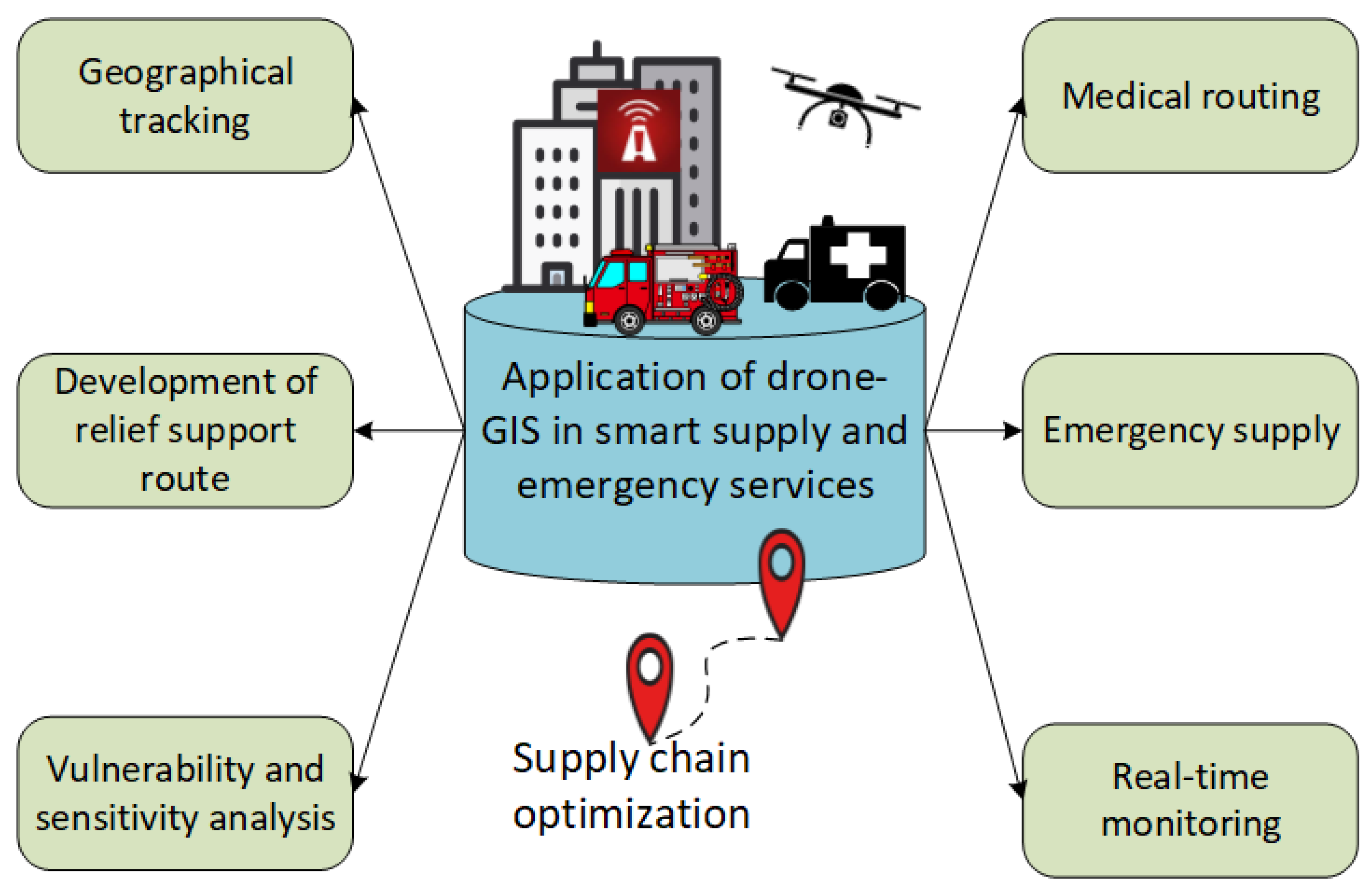

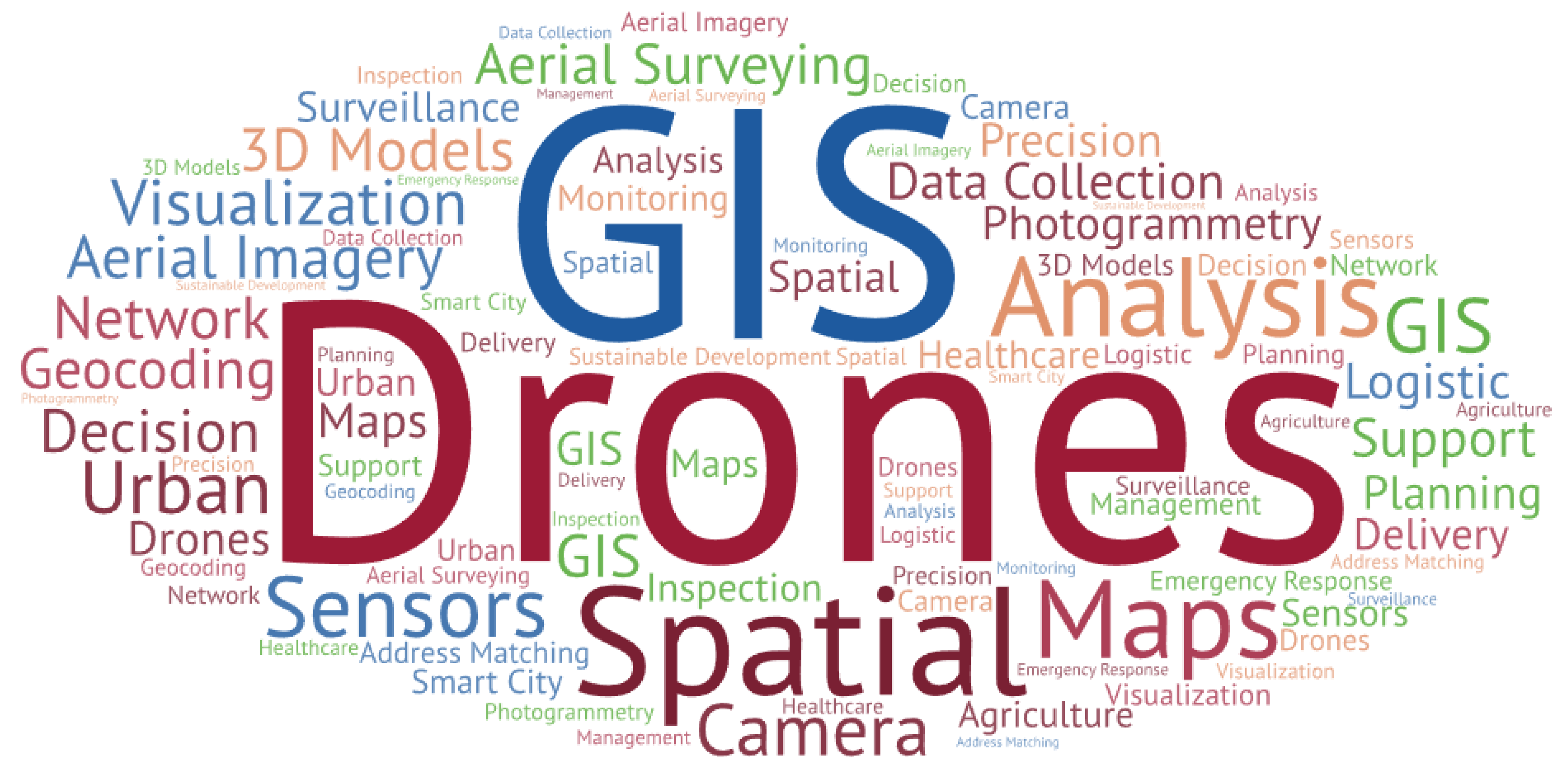
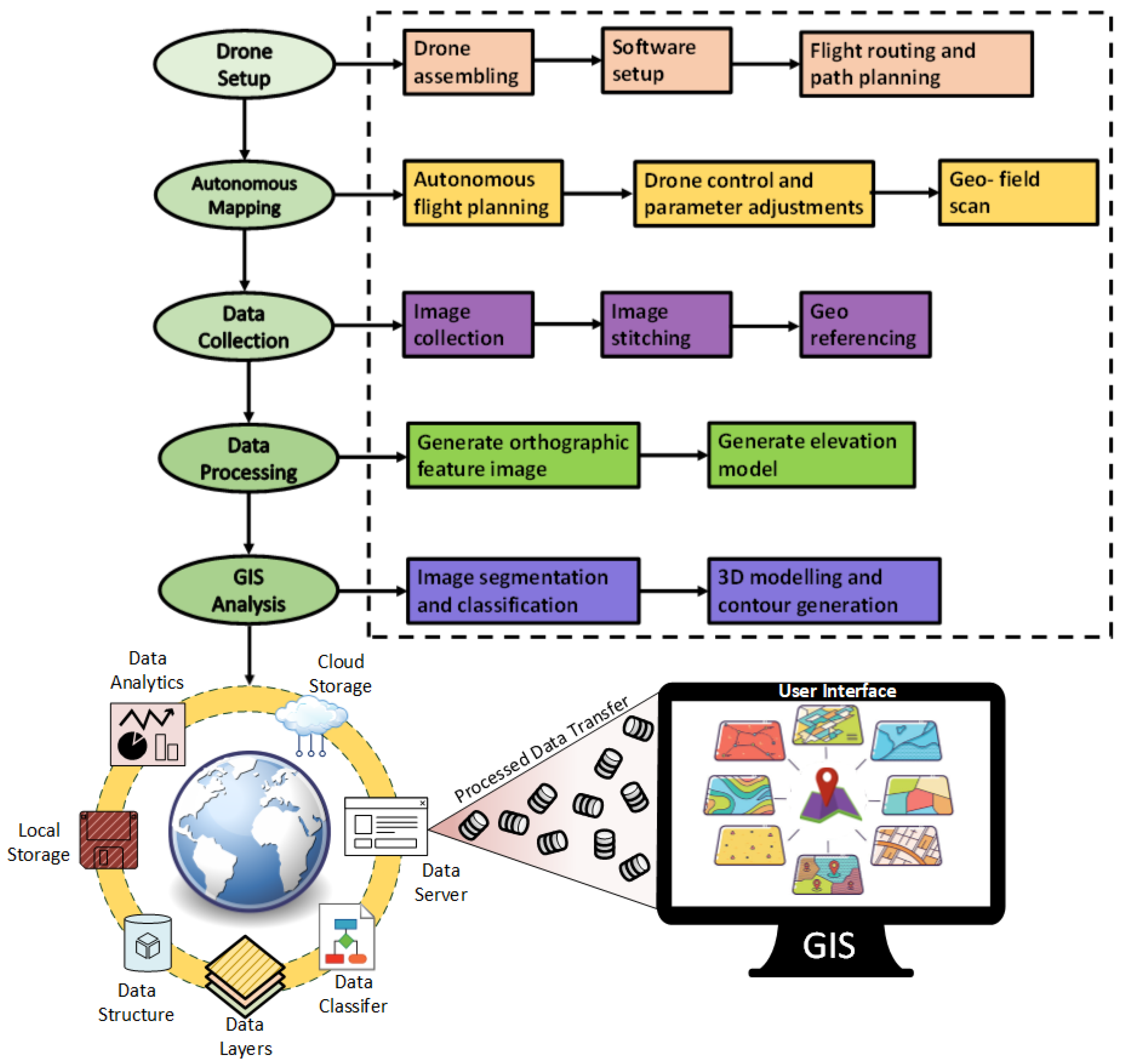
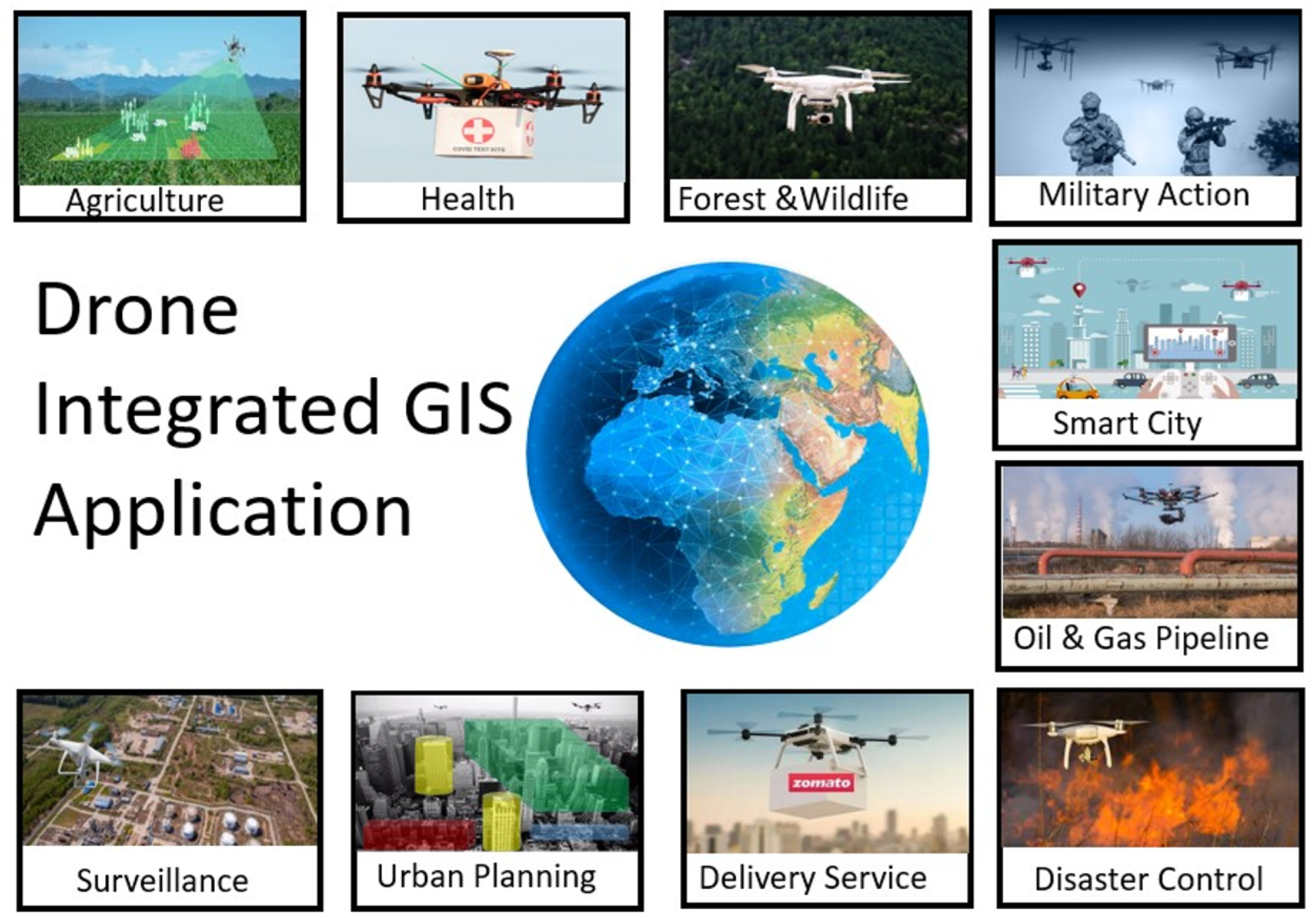
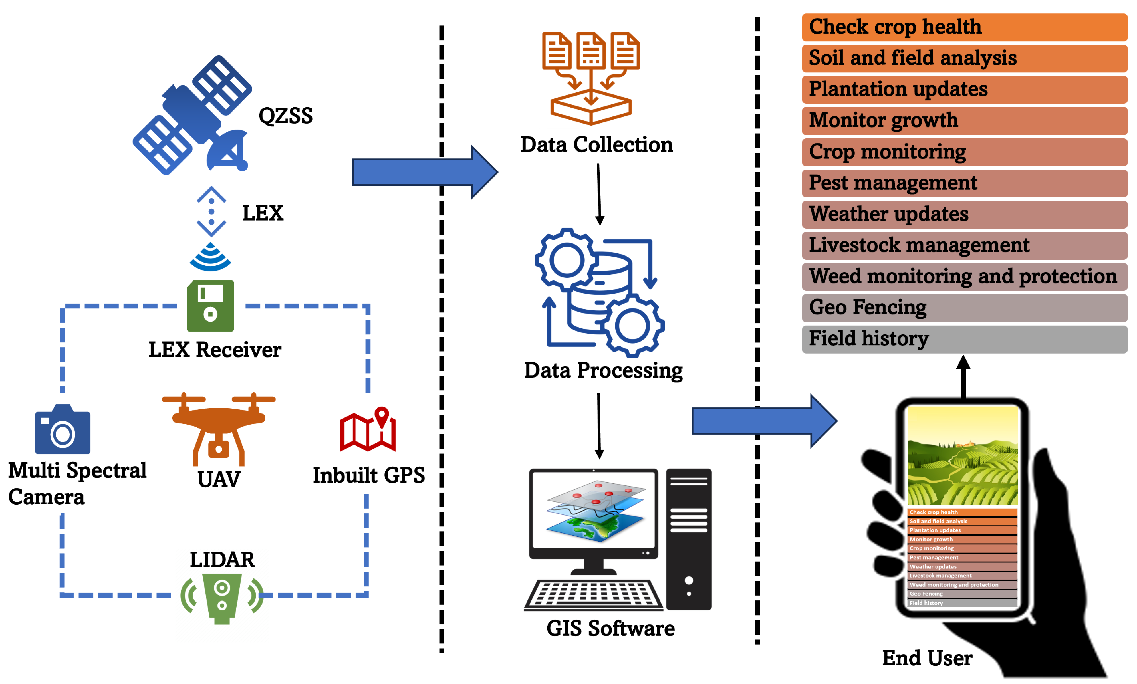