Abstract
The world faces the threat of an energy crisis that is exacerbated by the dominance of fossil energy sources that negatively impact the sustainability of the earth’s ecosystem. Currently, efforts to increase the supply of renewable energy have become a global agenda, including using solar energy which is one of the rapidly developing clean energies. However, studies in solar photovoltaic (PV) modelling that integrates geospatial information of urban morphological building characters, solar radiation, and multiple meteorological parameters in low-cost scope have not been explored fully. Therefore, this research aims to model the urban rooftop solar PV development in the Global South using Bandung, Indonesia, as a case study. This research also has several specific purposes: developing a building height model as well as determining the energy potential of rooftop solar PV, the energy needs of each building, and the residential property index. This study is among the first to develop the national digital surface model (DSM) of buildings. In addition, the analysis of meteorological effects integrated with the hillshade parameter was used to obtain the solar PV potential value of the roof in more detail. The process of integrating building parameters in the form of rooftop solar PV development potential, energy requirements, and residential property index of a building was expected to increase the accuracy of determining priority buildings for rooftop solar PV deployment in Bandung. This study shows that the estimated results of effective solar PV in Bandung ranges from 351.833 to 493.813 W/m2, with a total of 1316 and 36,372 buildings in scenarios 1 and 2 being at a high level of priority for solar PV development. This study is expected to be a reference for the Indonesian government in planning the construction of large-scale rooftop solar PV in urban areas to encourage the rapid use of clean energy. Furthermore, this study has general potential for other jurisdictions for the governments focusing on clean energy using geospatial information in relation with buildings and their energy consumption.
1. Introduction
The global increase in population growth and economic activity has resulted in a sharp rise in energy demand. Therefore, the world faces the threat of an energy crisis [1,2,3,4,5,6]. This condition is exacerbated by the dominance of fossil energy, which has negatively impacted the earth’s ecosystem. In 2019, world energy consumption reached 583.9 EJ, or equivalent to 162,194.4 TWh, with a fossil energy contribution of 84.3% [7]. One of the direct impacts of the use of fossil energy is the formation of greenhouse gas emissions, which have resulted in increasing temperatures in this century [8]. To maintain the continuity of life on earth, efforts to increase the supply of clean, renewable, and environmentally friendly energy have become a global agenda initiated worldwide [4,9]. As the largest energy user, especially in Southeast Asia, Indonesia’s energy consumption figures reached 989.9 million BOE (barrel of oil equivalent) in 2019, which drove urgent attention to the effort to increase national clean energy production [10].
One of the potential clean energies undergoing intensive development worldwide, including in Indonesia, is solar energy. The use of solar power plants as an energy source has several advantages, including being environmentally friendly [11], having a long service life which supports sustainability [12,13], maximizing energy harvest by geographical location, reducing imported fuel, having a simple installation process, and also having low maintenance [14]. With these various advantages of solar energy, the clean energy sector has become a nationally prioritized sector [15]. However, with the potential to reach 207 GWh, approximately 145.81 MW power capacity of solar energy has been installed in 2019 [15]. Therefore, in planning the development of renewable energy, especially as mixed energy, policy and regulatory support from the government are needed for optimal operation [16]. One of the efforts currently underway by the Indonesian government is setting a target for solar power generation capacity, which is to reach 6.5 GW by 2025 [17]. In addition, the Indonesian government has also set a target for the mandatory use of a minimum of 25% of the roof area for building solar power plants roofs on high-end buildings development [17].
An urban area can be characterized by a combination of dense population, complex social and economic activities, and the existence of the built environment [18]. Urban areas typically have a much higher need and increase in energy demand compared to rural areas [18,19]. Moreover, the dense population often encourage urban settlement expansion that results in limited green open areas at the expense of built-up areas [20]. Solar photovoltaic (PV) systems installed on the rooftop of buildings have the potential to provide sources for a clean energy development solution in urban areas. The deployment of rooftop solar PV has been increasing in recent years, especially with the increased interest in the net-zero energy building (NZEB) concept [21]. In NZEB, buildings produce their energy at least the same as they consume [21]. To achieve NZEB levels, buildings are expected to install sustainable energy sources such as rooftop PV systems, especially for high energy-consuming buildings such as commercial and high-end residential buildings [21,22].
Installing rooftop solar PV in urban areas requires obtaining information about the potential electricity generated for planning the capacity of the PV system to be installed [23,24]. Remote sensing technology could support data generation for determining the potential development of solar PV in an area [25,26]. It is possible to utilize the continuous availability of data at a specific temporal resolution with a comprehensive area coverage to occasionally monitor changes in PV system potential [27]. In addition to remote sensing data, in planning the solar PV installation on the buildings’ roofs, detailed building information is needed to calculate the effect of roof shadows, as well as the impact of roof slope and roof orientation to obtain optimal energy results [28].
There are several previous studies on planning the development of renewable solar energy in urban areas. In Suomalainen et al. [28], an analysis of the annual shortwave radiation value was conducted on each meter of the roof of the house using lidar data integrated with other parameters such as meteorological factors, roof orientation, roof slope, and shadows of objects around the roof. Hong et al. [29] conducted subsequent research with hillshade analysis to determine hourly energy harvest and the area available for solar PV construction on a rooftop. In Desthieux et al. [30], a lidar digital surface model (DSM) was used, which was able to determine the solar PV potential on roofs and walls of buildings using a shadow scheme. The previous research has determined the energy potential of rooftop solar PV in buildings using Lidar data and solar radiation. Lidar data need an expensive measurement, so not many cities and countries are able to perform this analysis. However, in 3D building, reconstruction requires cheaper measurement [26].
In addition, in a detailed building information research, the data used are lidar data as a three-dimensional building model. These types of data are relatively expensive when conducted in a large area, which restricts data access to all urban areas. In addition to research related to the potential of rooftop solar PV, there are several studies related to determining the optimal solar PV installation area. Gašparović and Gašparović [31] sought to determine the optimal location for installing a solar power plant in the Republic of Croatia by using land cover criteria, terrain geomorphology, global horizontal irradiance (GHI), and socio-economic parameters. In addition, Mukisa et al. [32] determined the most suitable location for the development of solar PV in energy trading using energy demand parameters, greenhouse gas parameters, location parameters, and economic parameters in Uganda. However, previous studies for determining the optimum potential were still conducted regionally and were not specific to the building level which shows a research gap and limitations. Therefore, it is necessary to develop solar PV studies in urban areas using various meteorological factors integrated with detailed building information models that can be extended from geospatial data. In addition, it is necessary to develop extensive studies for planning the optimal location for installing solar PV at the building level that can support the deployment of solar PV efficiently. For such a purpose, it is important to consider the energy consumption in the buildings so that the installed PV systems can have optimal utilization. For a specific case study, such as in Indonesia, where the installation of solar power plants is relatively still expensive [33], it is also important to classify which type of buildings can afford rooftop PV systems, e.g., high residential property buildings.
Considering the urgency of research needs and the importance of geospatial information in building level for rooftop solar PV construction in urban areas, this research has several specific objectives: developing a building height model, determining the energy potential of rooftop solar PV, defining the energy needs of each building, and specifying the residential property index. This study is the first to develop the national digital elevation model as open-source data in the digital surface model (DSM) of buildings. In addition, to obtain a more detailed solar PV potential value for the roof, the analysis of meteorological parameters, such as precipitation, air quality, and surface temperature, in combination with hillshade parameters are performed. The process of integrating building parameters in the form of rooftop solar PV potential, energy requirements, and the residential property index of a building is expected to increase the accuracy of determining priority building potential in rooftop solar PV construction. It is expected to be implemented massively in other areas with ease and with a high accuracy value using open-source data and detailed analysis. The ease in analyzing the priority of installing rooftop solar PV is expected to help the government and the community and encourage the increase in rooftop Solar PV usage alignes with the SDGs Energy goals, primarily target 7.2 by 2030: increase in the global percentage of renewable energy in the global energy mix.
2. Materials and Methods
2.1. Research Area
The study area for this research is Bandung, Indonesia (Figure 1). Bandung is an urban area with the economy that relies heavily on creative industries and businesses. It has a population of 2,480,464 in 2019 and is one of Indonesia’s most densely populated cities, with 14,608 people/km2 in 2021 [34]. Bandung is located in the Bandung Basin area with varying heights and slopes. Geographically, the location of Bandung is at 107°0′36” East Longitude and 6°0′55” South Latitude, with the southern part being at the lowest altitude, reaching 675 m, and the northern area being the highest part reaching 1050 m above sea level. Bandung is exposed to the sun throughout the year, with an average temperature of 25.8 °C and a total of a rainy days of around 227.04 days in 2020 [34]. The research area was selected because the city of Bandung is an area with variations in slope values, building heights, population size, urban activities, and consist of diverse society. In addition, Bandung is one of the cities chosen as a smart city model in Indonesia [35,36]. In terms of data availability, Bandung is one of the cities with a good data availability in Indonesia, starting from the availability of the statistical data, maps with detailed 1:5000 scale, building height models on Google Earth Pro, and 3-dimensional (3D) building data processed using lidar-photogrammetry in several areas. In addition, the high energy consumption making Bandung a strategic area for the pilot model of the renewable energy transition. In the city of Bandung, there are 849,421 state electricity company (PLN) customers in the household sector, with the highest energy consumption reaching 1,585,382 MWh in 2018 [34].
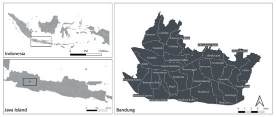
Figure 1.
The research study area of Bandung, Indonesia.
2.2. Data
This study integrated several geospatial data sources to model the priority areas for the optimal and accurate solar PV rooftop development. Table 1 shows the specifications of the data used in this study. Table 2 defines the distribution of data usage in more detail for several specific purposes: modelling the potential of solar PV, modelling energy consumption, modelling the residential property index, determining the optimum installation of solar PV, and comparing results. The data types are divided into three major groups: tabular data, vector data, and raster data.

Table 1.
Data specification used in this study for Bandung Area.

Table 2.
Distribution of data used for a specific purpose.
2.2.1. Tabular Data
The tabular data used in this study are energy consumption statistics, population statistics in each sub-district, and hourly average solar PV profile data. Data on energy consumption and population in 2018 were obtained from the Central Statistics Agency (BPS) [47]. Energy consumption data refers to the consumption of energy for one year in the household sector. Energy consumption data usage determines the annual electricity consumption of residents in Bandung. Population data for each sub-district usage aimed to determine the number of people living in a sub-district. Furthermore, statistical data of the average hourly solar PV profile from the Global Solar Atlas [37] is used to compare with the result of modelled solar PV profile.
2.2.2. Vector Data
The vector data used in this study are data of building footprints, building height, sub-district boundaries, tourism points, health facilities, public facilities, educational facilities, transportation facilities, roads, and 3D building data (Level of Detail 1) of photogrammetric lidar measurements in several areas. LOD 1 (level of detail 1) means that a building is only represented with one building height [24,48]. Building footprint data [38] with a scale of 1:5000 are the primary data used to delineate every building in Bandung on the sub-district boundaries through the modelling of the energy consumption of buildings from the total population of each sub-district. Furthermore, this research used 3D building data from Google Earth Pro [39] to improve the accuracy of the building height models in the form of 3D models using the National Digital Elevation Model (DEMNAS). In addition, this research used data from tourism locations [40,41], health facilities, public facilities, educational facilities, transportation facilities, and roads [38] to model land value, where the closer it is to the object, the higher the land value in the area. Furthermore, this research used the building model height data LAPI [42] from the results of lidar and photogrammetric measurements found in a small part of the Sukajadi sub-district for comparing the results obtained with the DEMNAS analysis.
2.2.3. Raster Data
The raster data used in this study are DEMNAS, shortwave radiation, land surface temperature, aerosol optical depth (AOD), and precipitation. DEMNAS data [38] have a spatial resolution of 8–10 m with a vertical datum of EGM 2008, that is constructed from several data; they are IFSAR with 5 m spatial resolution, Terrasar-X with 5 m spatial resolution, and ALOS PALSAR with 11.25 m spatial resolution with mass point data resulting from stereo plotting. DEMNAS data comprise DSM data extracted to get the digital terrain model (DTM) and building height values. This research used DEMNAS data to model building heights throughout Bandung. Furthermore, the primary data for modelling the energy potential of rooftop solar PV are shortwave radiation [43] which is the average shortwave radiation data for one month. The sunlight that reaches the earth could not completely reach the roof of the building however meteorological factors could reduce the intensity of the shortwave radiation. The meteorological data used include AOD data [44] to correct shortwave radiation value. The thicker the fine dust that covers the atmosphere of an area, the lower the shortwave radiation hitting the building roof. Precipitation data [45] help this research find the cloud block of an area. If the potential for rain in the area is high, clouds block the shortwave radiation in the area during the rain. Next, the land surface temperature data are considered [46], where the ambient temperature is too high, causing a decrease in the work efficiency of the solar PV cell. This research used land surface temperature data to model the potential of rooftop solar PV as correction data for the effectiveness of solar panels.
2.3. Methodology
This study has several planning stages for the construction of rooftop solar PV in urban areas using open data. The first stage is the extraction of the building height in Bandung, followed by the second stage, the modelling of the solar PV potential of the roof of the building. The third stage is modelling energy consumption for each building. The fourth stage is modelling the distribution of the residential property index in the city of Bandung, and the fifth stage is prioritizing buildings to build Solar PV rooftops based on aspects of energy potential, energy consumption, and the residential property index. Furthermore, after obtaining the priority buildings, an analysis of the selection of the optimum roof part of the building is done for roof solar PV and the optimum angle for installing solar PV roofs on the building. Figure 2 shows the overall research framework.
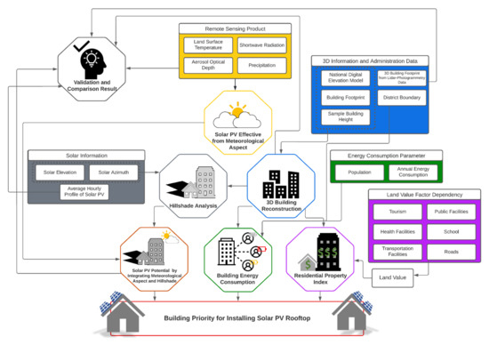
Figure 2.
The general framework employed in this study.
2.3.1. Reconstruction Height Building Using DEMNAS
This study developed the building height model using DEMNAS data. Misra et al. [49] and Girindran et al. [50] created the reconstruction of building height using an open DSM. This research continued the development of DEMNAS data by Ihsan et al. [24] in constructing 3D buildings using DEMNAS. The output obtained from this process is the height of the building and the digital surface of the building model. The first process of forming a 3D building model is to filter the DEMNAS data to retrieve only the terrain using the filtering method with slopes [51]. Raster in the landscape form was converted into a point and only at selected points, not in the building. After obtaining the terrain points, Triangular irregular networks (TIN) spatial interpolation was the next step in forming the Bandung DTM [52,53]. The following step was to calculate the building height from the results obtained using Equation (1) [54,55]. Furthermore, the extraction of building height results for buildings in Bandung uses the maximum pixel value so that the height of the ground does not affect the results of the 3D model. Subsequently, this research found an enhancement in accuracy using existing Google Earth Pro 3D model data in Bandung, which totaled 119 buildings. Data on building heights that have the same value in extraction with DEMNAS were averaged, and afterwards, a correlation of 0.738 was obtained, which indicates that the two data have a high positive correlation [56,57]. As a comparison, the process of enhancing accuracy using linear regression with least squares to determine the multiplier and constant has been used in previous studies [50,58,59]. The equation obtained from Bandung model data was further utilized to enhance the accuracy of the building height as shown in Equation (2). Hereafter, the building DSM model is determined using building height data using the result from accuracy enhancement and DTM. Previously, the vector data of the building height were changed into a raster-shaped building height with a resolution of 1 m. The resolution of 1 m was chosen as it is capable to preserve the shape of the building. Furthermore, the building height data were combined in the raster and DTM by using Equation (3).
2.3.2. Solar PV Potential on the Rooftop Using Meteorology and Hillshade Analysis
In determining the potential for solar PV, this study integrated two previous approaches: the use of meteorological data [27] and the hillshade analysis for determining the potential for solar PV in producing hourly energy on the building roof [29,60]. These approaches were integrated to obtain more sensitive and accurate potential solar modelling results. In determining the potential for effective solar PV using meteorological data, this study adopts the equation from Principe and Takeuchi [27], which develops on the prior equation used by Liu et al. [61]. The modification made in the equation is that the efficiency of the solar cell is not included due to the expected output being in the form of solar PV potential from meteorological data. Equation (4) determines the solar PV potential for meteorological effects. R is solar radiation (W/m2); is surface temperature correction; precipitation correction and AOD; is effective solar PV from meteorological data. Equation (5) determines the surface temperature correction, where 0.094 is the efficiency coefficient of LST, NOCTmax is 45 °C, and n is the number of days [27,62]. The precipitation and AOD correction are presented by Equation (6), where 0.035 is the coefficient of effectiveness of AOD [63] and precipitation, is the value of AOD on a day, and is the binary value when it rains or not. If it rains, the value is 1. Meanwhile, it is 0 when it does not rain. A rainy day is reviewed if the precipitation in the investigated area is >7 mm/day [64].
The next step was hillshade analysis to determine the potential for solar PV on the roof of the building more sensitively. The hillshade analysis calculation used in this study adopts the equations in the research of Hong et al. [29]. This study applies some modification in the analysis since this study utilized the average monthly solar radiation. This study used the daily hillshade average data to estimate the hourly radiation. Equation (7) is the hillshade equation used for determining the value for each pixel. The equation aimed to set the hillshade value for each pixel [65,66]. This study used hillshade analysis for 12 h from 07:00 to 18:00, where the monthly data are collected on the 15th day of each month. To estimate the azimuth and zenith of the sun at each hour, the online sun position calculator data from NOAA ESRL is used [67]. Equation (8) determined the average daily hillshade to estimate the total daily radiation using Equation (9). Approximately 4.958 pixels of the building roof centroid are used in calculating the average pixel value in Bandung. This step aimed to acquire the average hillshade value from the sun’s angle without influencing other shadows around it. Therefore, the solar radiation value is closer to the actual value, where is the average hillshade, is the hillshade value at the “ith” hour, and is the value of solar radiation resulting from meteorological and hillshade calculations.
H = 255 × {[Cos(Zenithrad) × Cos(Sloperad)] + [Sin(Zenithrad) × Sin (Sloperad) × Cos(Azimuthrad) × Cos(Aspectrad)]}
2.3.3. Estimated Energy Consumption of Each Building
Energy consumption is an important factor in defining suitable buildings for rooftop PV installation [21]. Techno-economically, a high energy-consuming buildings are among the most suitable places to install rooftop PV systems, considering that local energy production will be mostly self-consumed, leading to a more efficient PV utilization [68]. In this study, the building energy consumption model is aimed to identify buildings with intensive energy consumption.
Energy consumption is closely related to the number of people inhabiting an area [19,69,70]. In addition, energy consumption in each building relates to building area [19,71] and building height [72]. This study considered the number of people who inhabit a building to estimate the energy consumption of the building. This research used two methods of approach to specifying the number of residents in a building: determining the volume (area multiplied height) of the total available facilities in an area and multiplying the result with the number of buildings located in the investigated area. To increase the sensitivity of the results, estimates of the inhabitant of each building were conducted in each sub-district in Bandung with the total population and entire buildings using data from each sub-district. The first approach determines the total volume in the area. The number of residents in the sub-district area is used to estimate the number of occupants in each building. Equation (10) is applied in the first approach. The first approach is limited due to a residential property with a large area may have many occupants that exceed the reasonable limit of the number of people who inhabit a building. Conversely, some residential properties might have very few occupants. Therefore, to cover the shortcomings of the first approach, an estimate of the number of building occupants was conducted using the total number of buildings divided by the total population in the area. Equation (11) is used in the second approach. The second approach should help to obtain the same number of people in the entire building. The limitation of this approach is that all buildings have the same tendency regardless of building morphology. The number of people in each building was then averaged to compensate for the limitation of the two approaches. Furthermore, after obtaining the average number of people who inhabit each building, the energy consumption of each building can be determined by using the energy consumption data per capita in households of Bandung using Equation (12).
2.3.4. The Residential Property Modeling
The residential property model in this study is used to analyze buildings categorized from lower-end to higher-end spectrum based on a set of given criteria. As mentioned earlier, according to the national plan and new regulation, high-end residential developments are required to cover at least 25% of their rooftop with solar PV [17]. It is expected that these building owners can afford rooftop solar PV systems. It should be noted that in Indonesia, the electricity provider is still subsidized for middle to lower-income citizens [33] and these classes have low purchasing power to utilize the rooftop PV systems, in which the capital expenditure (CAPEX) is still considered expensive for some people [16].
This study used a multi-criteria analysis (MCA) approach to develop a residential property index [73]. The parameters used to determine the residential property index include land value [74], building height [75], building area [76], and building density [77]. In determining the land value index, a point-to-object distance approach was used for increasing the land value of an area, which included elements such as the distance from tourism objects [78], public facilities [79], health facilities [80], transportation facilities [81], and schools [81]. In Equation (13), there must be two coordinate points, 1 and 2 . After obtaining the distance for each object, the next step is weighting using Equation (14). This weighting aims to determine the value of a point compared to other points in the area where the closest distance has a score of 5, and the farthest distance has a score of 0. After obtaining a score for each object, the average score of all objects could be calculated to represent the area’s land value. Furthermore, the height and building area data were scored based on the types of common buildings in Indonesia based on White [82]. In determining the building density score, this study refers to the government guidelines for classifying slum areas [83].
All parameters are integrated using the same weight assumption. After obtaining the total value of all parameters, the class division was based on the property index categorized from low- to high-end residentials using the natural break classification method chosen to classify data based on the natural grouping inherent in the data [84].
2.3.5. Building Priority for Rooftop Solar PV
Three main criteria were combined to determine the priority of buildings for rooftop solar PV installation: energy availability (obtained from the solar PV potential of the roof in each building), energy consumption (based on building energy consumption modelling), and building conditions (obtained from modelling residential property buildings). Before integrating all the criteria, the data were classified for solar PV potential and building energy consumption into 10 classes using the natural break classification [84]. The potential of solar PV used in this study is the result of the average potential of the roof of the building. After obtaining 10 classes for the 3 criteria, the next step is to integrate the sum of all criteria with the same weight. From the summation, a range of 3–30 could be obtained. Using this range, the results were divided into 10 priorities, where each priority class has 2–3 priority classes for producing more sensitive results.
In this study, it is assumed that the rooftop PV installation is intended for the building self-consumption purpose, disregarding the PV power exchange possibility with neighbor buildings via the distribution grid. Therefore, the rooftop PV utilization potential in a certain building is independent of the PV utilization potential in the surrounding buildings. This limitation is based on the finding that solar overproduction can cause problems for the power grid, such as voltage fluctuations and cable overloading [85,86]. On top of that, the utilization of locally PV energy production in buildings will be much more efficient if it is directly self-consumed, which also leads to high self-sufficiency of the buildings [87]. These assumptions will be suitable for calculating PV deployment potential in Bandung, mainly attributed to the local power grid conditions. Due to the intermittent nature of PV production, the instantaneous mismatch between the production and the consumption is hard to avoid. However, it can be minimized with the deployment of battery energy storage systems and demand-side management [68], which can be implemented in the studied buildings.
2.3.6. Optimum Rooftop Solar PV Installation Planning
After identifying the priority building for installing rooftop solar PV, the next step is determining the location for installing rooftop solar PV to produce optimum energy. In planning, installing a solar PV Roof is based on the optimum roof location and installation angle. This method determines the optimum location for solar PV installation [60]. The modifications carried out in this study did not include a binary approach for determining the installation area but the average of a sample of 4958 buildings at 12:00 noon as the optimum value. Furthermore, after obtaining the optimum value, the hillshade pixel value was changed. If it is greater than or equal to the optimum pixel value, it is worth 1. In contrast, if the value is less than the optimum pixel value, it is changed using Equation (15). For example, the value of 1 is intended to indicate the optimum value in a day. This treatment is intended to provide a more sensitive analysis of pixel values that still show a hillshade value of more than 0. The area still has potential but is not as large as the optimum value.
where is the total effectiveness of a day, is the hillshade value at a specified hour, and is the average hillshade value at 12:00 noon. The next step is developing priority locations based on the average value of total effectiveness in one year. In determining the optimum angle for installing rooftop solar PV, we adopted Nazmul [88]. The modifications made in this study were not to experiment every month in determining the optimum angle estimate but only to use the month with the highest rooftop solar PV value. In determining the optimum tilt angle in Equation (18), we need the angle of declination and sunset angle, which can be calculated using Equations (16) and (17), respectively. The equation used is the equation for the north-facing surface:
where is the declination angle, n is the number of days of the year, is the sunset angle, is the latitude angle, and is the optimum tilt angle.
3. Results
3.1. Reconstruction of Building Height Model
Figure 3 shows the digital surface model of the building. The result comes from building height that is integrated with the digital terrain model of Bandung. Therefore, the given DSM model only focuses on adding building height to the DTM formed. The results of this height model are used for analysis in the next stage. The building height in Bandung from DEMNAS data, where the estimated building height is 5–36 m from the earth’s surface. The results of data processing, in general, can be used to model every building height in Bandung. However, the 8 m resolution of DEMNAS makes several adjacent buildings to have the same height. Therefore, as can be seen from the distribution of building heights, several tall buildings should not exist in the northern part. This tall building was built because, at the time of establishing the DTM, it could not produce a good model for hilly areas, such as in the northern area of Bandung. Figure 3 also shows that Bandung has a relatively significant difference in height between the north and south, where the elevation ranges from 655 to 1070 m above the geoid. This condition becomes an obstacle when visualizing the results, especially in the northern part of Bandung, which has a high-altitude difference from other areas.
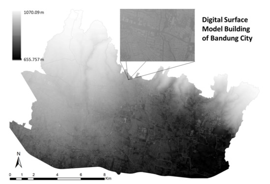
Figure 3.
Digital surface model building of Bandung City.
3.2. Solar PV Effective Model
Figure 4 shows rooftop solar PV potential based on an hourly meteorological effects average per month in 2018. The effective solar PV potential modelled in Bandung ranges from 351.833 to 493.813 W/m2. The effective solar PV potential for meteorological effects changes every month due to the annual movement of the sun. When viewed from the distribution, effective solar PV is higher in value in the suburbs of Bandung, such as Cidadap, Mandalajati, Cibiru, and Ujung Berung sub-districts, than in downtown areas such as Sumur Bandung, Regol, Lengkong, and Astana Anyar. This condition is due to the dense activity in the downtown area increasing the surface temperature. Besides that, the number of motorized vehicles in the area also results in high dust, so solar radiation experiences a higher barrier. The results of the hillshade analysis in Bandung were obtained every hour starting from 07:00 to 18:00, as shown in Figure 5. This visualization shows the result for January, but the analysis was conducted every month in the process. In hillshade analysis, the range of values given in integers ranges from 0 to 255, where 0 indicates very low irradiation intensity (dark) and 255 indicates very high irradiation intensity. Figure 4 shows that the highest intensity of solar radiation is approximately 11:00 to 13:00. Using hillshade analysis indicates that the results of the shadow of a building that covers the roof of another building can be modelled, which impacts the calculation of energy from solar PV produced. The roof’s shadow made the energy potential in area 0 due to the absence of sunlight. This hillshade analysis explains that the potential for solar PV is low at certain hours and even 0 because the sun’s intensity decreases.
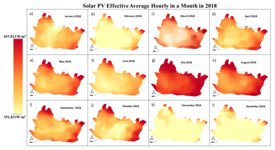
Figure 4.
Solar PV effective average hourly in a month in 2018 ((a) January, (b) February, (c) March, (d) April, (e) May, (f) June, (g) July, (h) August, (i) September, (j) October, (k) November, (l) December).
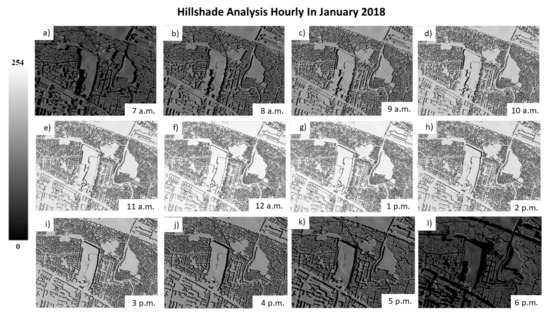
Figure 5.
Hourly hillshade analysis in January 2018 ((a) 7 a.m., (b) 8 a.m., (c) 9 a.m., (d) 10 a.m., (e) 11 a.m., (f) 12 a.m., (g) 1 p.m., (h) 2 p.m., (i) 3 p.m., (j) 4 p.m., (k) 5 p.m., (l) 6 p.m.).
After obtaining the effective monthly solar PV and hillshade analysis hourly, the next step is integrating the two data to get the average daily solar PV every month. Figure 6 shows the hourly energy potential of each month. The graph shows that the highest energy potential occurs in July, while the lowest energy potential occurs in December. This condition is due to the apparent annual circulation of the sun. From July to September, the sun moved to the southern hemisphere, and from December to January, the sun moved to the north. In addition, the average daily potential in Bandung is approximately 4.522 kWh/m2, with minimum energy in December of 3.522 kWh/m2 and the highest in July of 5.206 kWh/m2. Figure 7 shows the total solar PV potential in one year, which is a combination of the daily potential of each month. The total solar PV potential in Bandung ranges from 233.067 to 2122.102 kWh/m2. The distribution shows that open land areas have a higher potential than areas with dense buildings. This condition is due to buildings that block sunlight in the area. However, a closer look at each roof shows that the energy potential at the roof’s edge is lower than that in the center. This condition is because of the apparent daily movement of the sun, which makes the radiation at a specific time lean toward a specific side of the roof. In addition, the shadow effect of other buildings is also the cause of the difference in energy potential on the roof of the building.
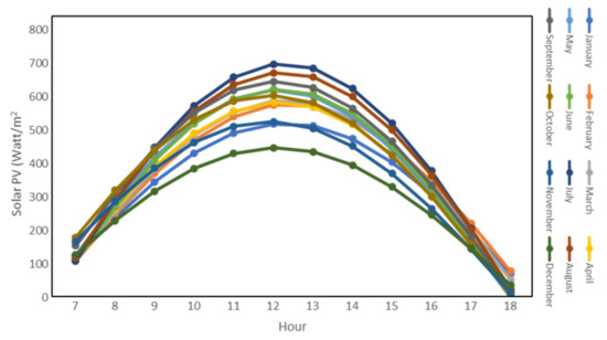
Figure 6.
Hourly solar PV with hillshade analysis.
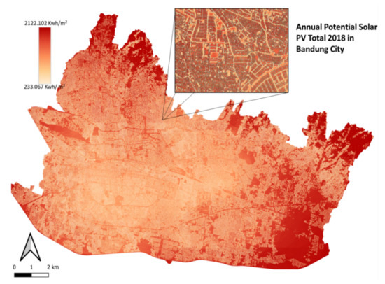
Figure 7.
The annual potential of solar PV energy in Bandung.
3.3. Building Energy Consumption
Figure 8 shows the modelling of the energy consumption of each building in Bandung. The energy consumption of buildings in Bandung ranges from 1.266 to 110.179 MWh. There are three dimensions of the building consumption value in several areas, where the height represents the required energy consumption value. Several buildings have the same area but different energy consumption due to the difference in the building heights. Predicting the population by using the number of each sub-district can also increase the model’s sensitivity. Areas B and C show this phenomenon where the conditions show buildings with the same area but produce different energy consumption estimates due to the different populations. Figure 9 shows the total energy needs of each sub-district in Bandung. The sub-districts of Babakan Ciparay, Bandung Kulon, Kiara Condong, and Coblong have higher energy needs than other sub-districts. This condition is in line with the large population in the four sub-districts and also the large number of population activities centered in the four sub-districts.
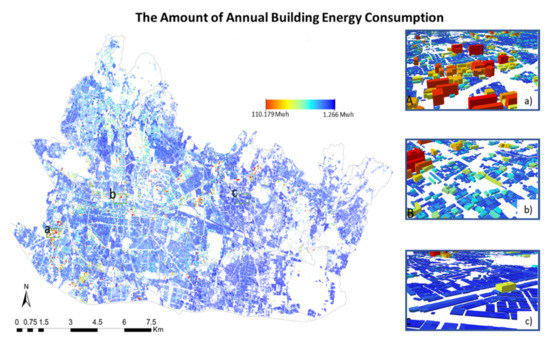
Figure 8.
The amount of annual building energy consumption (Selected area of 3D building consumption in: (a) Bandung Kulon District, (b) Coblong District, (c) Arcamanik District).
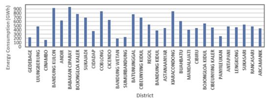
Figure 9.
Total Energy consumption of Bandung in every district in Mwh.
3.4. Residential Property Index
The residential property index can be a factor influencing the installation of solar PV for personal energy consumption. By knowing the type of a house, it was possible to determine the potential of homeowners in installing solar plants roofs on their homes. In the strategic plan of the Ministry of Energy and Mineral Resources regarding renewable energy for 2020–2024, it is stated that high-end residential building developments are obligated to install roof solar plants in at least 25% of the buildings, thus the results of the property index can help provide alternative data that can support the implementation of that particular policy. Moreover, the building with high energy consumption, with high-end residentials among them, should be prioritized for installing rooftop PV, especially if such buildings want to achieve NZEB, in which the energy consumption should match with their local energy production [21]. Figure 10 shows the mapping of the residential property index in Bandung. The statistical results for the five types of classes show that higher-end residential buildings dominate in the Bandung area accounting for 29% and 24%, respectively. The medium classification accounts for 15%, and the lower-end residential accounts for 22% and 10%, respectively. Therefore, Bandung has high distribution of high-end residential buildings throughout the city. This condition infers the average economic capacity of the residents of Bandung is high enough to install rooftop solar PV in their respective homes.
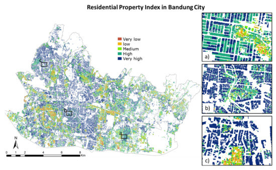
Figure 10.
Residential property index in Bandung from lower to higher-end of the spectrum (Selected area in: (a) Rancasari District, (b) Regol District, (c) Sukajadi District).
3.5. Building Priority to Solar PV Rooftop Installation
After obtaining the potential for rooftop solar PV, the building’s energy consumption and the type of residential property, the three results are integrated to get a priority building that needs a solar PV rooftop. In general, the three parameters developed in this study have their respective roles in planning the priority of buildings suitable for installing rooftop solar PV. The first parameter, which is the potential of rooftop solar PV, can be used as a reference if a building wants to implement a net-zero energy. The second parameter, the building energy consumption model, is primarily aimed at identifying buildings with high energy consumption. In these buildings, solar PV is expected to fulfil most of their energy needs, replacing the energy from the grid which is mostly coming from fossil fuels. The third one is the residential property index which is used to find the residential properties that have the highest potential for installing rooftop solar PV systems [16]. There are two scenarios used in this study, with and without the consideration of the residential property index. The first scenario is intended for the general public, which only views the energy production and energy consumption of each building. The second scenario is specific to the Indonesia case study, aligned with the policy that requires 25% on the roofs of high-end residential buildings to install solar PV. Thus, it should be noted that these approaches and assumptions will be suitable for assessing solar PV deployment potential in Indonesia, and might not be relevant for other countries with significantly different conditions and regulations. However, it is a useful case study for cities with similar characteristics, especially in the Global South.
In Figure 11, it can be seen the results of scenario 1. The results show that the distribution of the main priorities for the construction of rooftop solar PV is spread in Bandung. In scenario 1, high priority solar PV development, there are 1316 buildings. The three sub-districts with a high priority distribution are Babakan Ciparay, Bandung Kulon, and Batununggal sub-districts, with 210, 161, and 97 buildings. The results also show that the analysis of each building will produce higher detailed information to distinguish one building from other buildings in the vicinity.
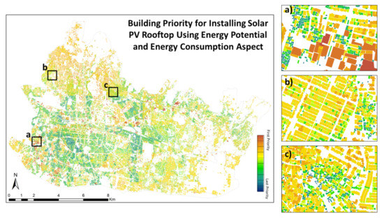
Figure 11.
Building priority for installing solar PV rooftop using energy potential and energy consumption aspect (Selected building priority scenario in: (a) Bandung Kulon District, (b) Sukajadi District, (c) Coblong District).
Figure 12 shows the results from scenario 2 where the main priority of rooftop solar PV development is distributed throughout the city. In the results of scenario 2, the priority of rooftop solar PV development is located on 36,372 buildings. The three sub-districts with a high priority distribution are Sukasari, Coblong, and Cidadap sub-districts with 4770, 3567, and 2512 buildings. There is a reasonably significant difference between scenarios 1 and 2 for the number of main priority buildings. The difference is that household energy consumption has a close value, so the main priority in the first scenario is high energy consumption. Meanwhile, in the second scenario, an additional residential property index parameter shifts the importance of some of the buildings that were not the main priority in scenario 1 to become the main priority due to the property characteristics.
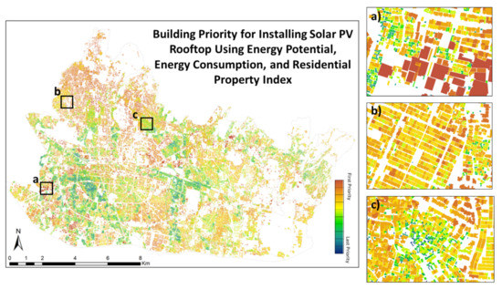
Figure 12.
Building priority for installing solar PV rooftop using energy potential, energy consumption, and residential property index (Selected building priority scenario in: (a) Bandung Kulon District, (b) Sukajadi District, (c) Coblong District).
3.6. Optimum Location and Optimum Tilt Solar PV Rooftop Installation
After identifying priority buildings for rooftop solar PV installation, the next step is ensuring that rooftop solar PV installations are correct for obtaining optimum energy absorption. In the optimum roof solar PV installation, two parameters to be analyzed are the optimum roof installation location and the optimum installation angle. Figure 13a shows the priority location of the optimum rooftop solar PV installation on each roof in Bandung. This study presents eight priority areas of installation.
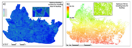
Figure 13.
(a) Optimum rooftop location for installing solar PV rooftop and (b) optimum tilt for installing solar PV rooftop (°).
When studied in further details, installation priority one is more in the center of the roof, while priority eight is dominated by the roof’s edge for building around the high building. Therefore, this installation plan shows that the best location for installing rooftop solar PV is in the middle of the building. After obtaining the location on the roof of the building that gets optimum sun exposure, the next step is determining the optimum solar PV installation angle. This optimum installation angle is determined based on the month with the highest solar PV potential, July, according to the results shown in Figure 6. Figure 13b shows the optimum tilt value for each building in Bandung. Based on this value, the optimum angle in Bandung is around 35 degrees, with the solar panel facing north. When viewed from the optimum tilt value, the position of the building significantly affects the amount of the optimum solar cell installation angle.
4. Discussion
4.1. Comparison of Solar PV Analysis per Building Using DEMNAS and Lidar-Photogrammetry Data
According to the quality of the building height model, this study compared the results of the developed height product with the accurate building height measurements obtained from building height data using lidar-photogrammetry. This height comparison was conducted in Sukajadi District using 7331 building samples and shows the results of comparing the two data, where the RMSE value of the model is 2.320 m. The highest error distribution is in the range of <1 m, which accounts for 34% of the total building sample, and the least error is in the range of >5 m which amounts to 3.4% of the whole building sample. The results found that the DEMNAS height model works well in low to medium buildings with a height of 5 m to 7 m.
A comparison of the use of the 3D model results from DEMNAS and the lidar-photogrammetry measurement product for determining the potential of rooftop solar PV aims to determine the influence of the difference in data usage. The comparison results show that, in general, there is no significant difference visually, but the results of processing using lidar seem more sensitive in each building. This result is due to the 8 m spatial resolution of DEMNAS, which makes several adjacent buildings have the same height. In contrast, buildings have different heights in densely packed areas with lidar-photogrammetry data. Furthermore, there was a pixel-to-pixel comparison to investigate further the difference between the solar PV rooftop potential results from the DEMNAS and lidar-photogrammetry buildings for obtaining the results in Figure 14. By comparing 696,373 pixels, a dependency coefficient value of 0.8275 or a correlation of 0.9097 was obtained, which means that both the data have a strong relationship. Based on the regression value, the results of the scale value show a value of 0.95, while the offset value is −0.14, which indicates that the two values are close to each other. The scatter plot shows several cases in which the solar PV potential value in the DEMNAS results building was higher than the solar PV results from the lidar-photogrammetry building model. This condition occurred due to the building model from the lidar-photogrammetry data being affected by the shadows of other buildings. Meanwhile, the DEMNAS is not affected because the buildings have the same height. In evaluating the resulting solar PV potential model, this study is not only analyzed using the differences in the constituent data. In addition, this research compared the results to another study, which considered the energy potential generated from global solar atlas processing [37]. Figure 15 shows the scatter plot of the hourly potential for each month of the model developed in this study with the processed results from the global solar atlas. These results show a very high correlation between the two data with a regression value that reaches a value of 0.967. The value of RMSE of the comparison model is 80.378 W with the mean bias error reaching −63 W.
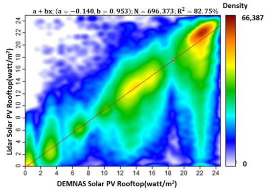
Figure 14.
Correlation of solar PV rooftop potential between DEMNAS and lidar-photogrammetry.

Figure 15.
Correlation between hourly energy model result and Global Solar Atlas hourly model.
4.2. Study Limitation and Possible Study Direction
In the development of this study, several limitations affect data processing results, as in the formation of 3D buildings in LOD 1. The detailed shape of each building roof that should influence generating solar PV potential remains unanalyzed. The equation from the enhancement process of height building from DEMNAS still only can be used in area study. In addition, the solar PV analysis based on meteorological data for solar radiation used a monthly average. The analysis assumed a constant value for the daily data in the same month. In determining the meteorological parameters, the influence of clouds has not been considered in detail, which should affect the radiance value that reaches the surface. The limitation of hillshade processing is that the data only included samples obtained at certain hours on the 15th day of each month. On the other hand, hillshade analysis only considers the building effect. While energy consumption is modelled considering the influence of population and building capacity, environmental factors and the social life of the building owner are overlooked. In this study, the population’s energy consumption considered all ages to have the same level of consumption. The residential property index modelling is used only for building morphology and land value. The classifications in determining the high-end residential buildings and incorporating the three planning aspects still use the same weight.
The temporal matching between PV energy production and the building energy consumption is commonly used to define the suitable buildings for installing rooftop solar PV. To capture the temporal matching of building energy consumption and solar diurnal patterns, the temporal resolution is ideally 1 h or higher for both solar power and building consumption. However, since the hourly energy consumption in the buildings is not available in this study, the annual energy consumption model is used instead. Even though the hourly temporal matching is not available, considering the annual energy consumption will still be highly relevant to defining the suitable buildings for installing rooftop solar PV since the chance of having the self-produced energy consumed within the buildings is higher if the annual energy consumption is high.
The possible development of studies in the future includes analyzing the shape of the roof of the building using data with higher resolutions, such as by using lidar [89], photogrammetry [90], and very high-resolution satellites [91]. The enhancement of reconstruction of 3D buildings can be processed with nationwide enhancement, so the result can be used in other cities [92]. Solar PV analysis can be improved by using solar radiation data with a higher temporal resolution which can be field data or satellite data. The use of time series analysis of high-density clouds [93] greatly affects solar PV’s value for potential meteorological effects. Improving hillshade analysis is possible by capturing more tightly timed data and considering the other object that can cause shadows on the rooftop, such as trees. Energy consumption increase is possible by using an analysis of environmental conditions and the social conditions of the owners. Population age data [94] aim to estimate the energy consumption of each building in more detail. The improving energy consumption aspect can also consider the urban population density gradient [95]. In addition, the improvement of residential property index modelling could be made while reviewing several other parameters such as building patterns, sanitation, physical conditions of buildings, and water availability. In classifying residential property index and planning classifications, their weight determination could use an analytical hierarchy process (AHP) and Principal Component Analysis (PCA) [96]. In future studies, building power consumption data with a temporal resolution of 1-h or higher can be used for a more accurate load matching potential assessment, which can help the city planner determine the most suitable buildings for installing rooftop solar PV. In addition, load matching indicators such as self-consumption and self-sufficiency are also recommended to be included in future studies. Moreover, city-wide household analysis can be integrated into a multi-hazard analysis assessment [97,98,99] that will benefit spatial planning of vital infrastructure strategic.
5. Conclusions
This study analyzed and presented the priority buildings for rooftop solar PV development in the urban Bandung. In supporting this primary goal, this research generated a building height model based on DEMNAS data, determining the energy potential of rooftop solar PV, derived the energy needs of each building, and mapped the residential property index. The analysis of building height modelling results showed the height of the modelled buildings in the city of Bandung that ranged from 5–36 m, with the highest error distribution in the range of <1 m, which accounted for 34% of the total building sample, and the least error in the range of >5 m, which amounted to 3.4% of the whole building sample. In the analysis of the effective energy potential, solar PV produced hourly energy of approximately 351.833 to 493.813 W/m2, whereas July is the month that has the highest daily energy potential of 5.026 kWh. The analysis of the energy consumption of buildings in Bandung showed energy needs of 1.266 to 110.179 MWh. A comparison of the coefficient of dependence on solar PV potential between the results of the morphology of the DEMNAS building and lidar-photogrammetry showed a highly correlated value of 0.8275. Building priorities based on the following three parameters were developed: the potential of rooftop solar PV, building energy consumption, and residential property index. The results of scenario 1 showed that 1316 buildings are prioritized for rooftop solar PV development in Bandung when using solar PV potential and building energy consumption aspects. Furthermore, the result of scenario 2 showed that 36,372 buildings are prioritized for rooftop solar PV development in Bandung when using solar PV potential, building energy consumption, and residential property index. The findings from this study indicated what can be achieved by using geospatial building level data and how models developed have potential policy implication in clean energy planning for sustainable development of Bandung specifically, and potentially other cities with similar characteristic especially in the Global South.
Author Contributions
A.D.S., K.T.N.I., T.S.A. and M.A. conceived and designed the experiments; A.D.S., K.T.N.I., Z.S. and N.A.S. performed the experiments; K.T.N.I., J.A., B.Y., M.A. and R.F. analyzed the data; K.T.N.I., P.O.H. and K.W. pre-processed the base datasets; A.D.S., K.T.N.I., T.S.A. and R.F. wrote the paper. All authors have read and agreed to the published version of the manuscript.
Funding
This research was funded by Capacity Building Research Program for ITB Young Scientists by the Institute of Research and Community Service Institut Teknologi Bandung and King’s College London Faculty Research Fund.
Data Availability Statement
The datasets generated during and/or analyzed during the current study are available from the corresponding author on reasonable request.
Acknowledgments
The authors are grateful to acknowledge the support from Institut Teknologi Bandung, and King’s College London. We also thank the anonymous reviewers whose critical and constructive comments greatly helped us to prepare an improved and clearer version of this paper. All persons and institutes who kindly made their data available for this research are acknowledged.
Conflicts of Interest
The authors declare no conflict of interest.
References
- Bakirtas, T.; Akpolat, A.G. The Relationship between Energy Consumption, Urbanization, and Economic Growth in New Emerging-Market Countries. Energy 2018, 147, 110–121. [Google Scholar] [CrossRef]
- Khan, M.K.; Khan, M.I.; Rehan, M. The Relationship between Energy Consumption, Economic Growth and Carbon Dioxide Emissions in Pakistan. Financ. Innov. 2020, 6, 1. [Google Scholar] [CrossRef] [Green Version]
- Chakraborty, S.; Li, J.; Bhattacharya, P. The Solution to the Global Energy Crisis with New Materials, and Sustainability. J. Phase Change Mater. 2021, 1. [Google Scholar] [CrossRef]
- Poudyal, R.; Loskot, P.; Nepal, R.; Parajuli, R.; Khadka, S.K. Mitigating the Current Energy Crisis in Nepal with Renewable Energy Sources. Renew. Sustain. Energy Rev. 2019, 116, 109388. [Google Scholar] [CrossRef]
- Raza, A.; Meiyu, G.; Gholami, R.; Rezaee, R.; Rasouli, V.; Sarmadivaleh, M.; Bhatti, A.A. Shale Gas: A Solution for Energy Crisis and Lower CO2 Emission in Pakistan. Energy Sources Part A Recovery Util. Environ. Eff. 2018, 40, 1647–1656. [Google Scholar] [CrossRef]
- Shevchenko, S.; Koval, A.; Danylchenko, D.; Koval, V. Energy Crisis and Electricity Reform of Ukraine-First Results. In Proceedings of the 2020 IEEE KhPI Week on Advanced Technology (KhPIWeek), Kharkiv, Ukraine, 5–10 October 2020; pp. 526–529. [Google Scholar]
- Looney, B. Statistical Review of World Energy 2020, 69th 2020. pp. 3–9. Available online: https://www.bp.com/content/dam/bp/business-sites/en/global/corporate/pdfs/energy-economics/statistical-review/bp-stats-review-2020-full-report.pdf (accessed on 6 June 2021).
- New, M.; Liverman, D.; Schroder, H.; Anderson, K. Four Degrees and beyond: The Potential for a Global Temperature Increase of Four Degrees and Its Implications. Philos. Trans. R. Soc. A Math. Phys. Eng. Sci. 2011, 369, 6–19. [Google Scholar] [CrossRef] [PubMed] [Green Version]
- Bölük, G.; Mert, M. Fossil & Renewable Energy Consumption, GHGs (Greenhouse Gases) and Economic Growth: Evidence from a Panel of EU (European Union) Countries. Energy 2014, 74, 439–446. [Google Scholar]
- IRENA Renewable Capacity Statistics 2021. Available online: https://www.irena.org/publications/2021/March/Renewable-Capacity-Statistics-2021 (accessed on 6 June 2021).
- Silveira, J.L.; Tuna, C.E.; de Queiroz Lamas, W. The Need of Subsidy for the Implementation of Photovoltaic Solar Energy as Supporting of Decentralized Electrical Power Generation in Brazil. Renew. Sustain. Energy Rev. 2013, 20, 133–141. [Google Scholar] [CrossRef]
- Hosenuzzaman, M.; Rahim, N.A.; Selvaraj, J.; Hasanuzzaman, M.; Malek, A.B.M.A.; Nahar, A. Global Prospects, Progress, Policies, and Environmental Impact of Solar Photovoltaic Power Generation. Renew. Sustain. Energy Rev. 2015, 41, 284–297. [Google Scholar] [CrossRef]
- Peng, J.; Lu, L.; Yang, H. Review on Life Cycle Assessment of Energy Payback and Greenhouse Gas Emission of Solar Photovoltaic Systems. Renew. Sustain. Energy Rev. 2013, 19, 255–274. [Google Scholar] [CrossRef]
- Mundo-Hernández, J.; de Celis Alonso, B.; Hernández-Álvarez, J.; de Celis-Carrillo, B. An Overview of Solar Photovoltaic Energy in Mexico and Germany. Renew. Sustain. Energy Rev. 2014, 31, 639–649. [Google Scholar] [CrossRef]
- ESDM. Indonesia Energy Outlook 2019. 2019. Available online: https://www.esdm.go.id/id/publikasi/indonesia-energy-outlook (accessed on 1 March 2022).
- Yu, L.; Li, Y.P.; Huang, G.H. Planning Municipal-Scale Mixed Energy System for Stimulating Renewable Energy under Multiple Uncertainties-The City of Qingdao in Shandong Province, China. Energy 2019, 166, 1120–1133. [Google Scholar] [CrossRef]
- ESDM. Rencana Strategis Kementerian Energi Dan Sumber Daya Mineral 2020–2024. 2021, p. 197. Available online: https://www.esdm.go.id/id/publikasi/rencana-strategis (accessed on 16 August 2021).
- Weeks, J.R. Defining Urban Areas. In Remote Sensing of Urban and Suburban Areas; Springer: Berlin, Germay, 2010; pp. 33–45. [Google Scholar]
- Zhang, M.; Song, Y.; Li, P.; Li, H. Study on Affecting Factors of Residential Energy Consumption in Urban and Rural Jiangsu. Renew. Sustain. Energy Rev. 2016, 53, 330–337. [Google Scholar] [CrossRef]
- Shukla, A.K.; Ojha, C.S.P.; Mijic, A.; Buytaert, W.; Pathak, S.; Garg, R.D.; Shukla, S. Population Growth, Land Use and Land Cover Transformations, and Water Quality Nexus in the Upper Ganga River Basin. Hydrol. Earth Syst. Sci. 2018, 22, 4745–4770. [Google Scholar] [CrossRef] [Green Version]
- Luthander, R.; Widén, J.; Nilsson, D.; Palm, J. Photovoltaic Self-Consumption in Buildings: A Review. Appl. Energy 2015, 142, 80–94. [Google Scholar] [CrossRef] [Green Version]
- Allouhi, A. Solar PV Integration in Commercial Buildings for Self-Consumption Based on Life-Cycle Economic/Environmental Multi-Objective Optimization. J. Clean. Prod. 2020, 270, 122375. [Google Scholar] [CrossRef]
- Pillot, B.; Al-Kurdi, N.; Gervet, C.; Linguet, L. An Integrated GIS and Robust Optimization Framework for Solar PV Plant Planning Scenarios at Utility Scale. Appl. Energy 2020, 260, 114257. [Google Scholar] [CrossRef] [Green Version]
- Ihsan, K.T.N.; Sakti, A.D.; Wikantika, K.; Safitri, S. Development of Low-Cost 3D Building Model Using National Digital Elevation Model in Urban Area of Bandung City, Indonesia. ECS Trans. 2022, 107, 16973. [Google Scholar] [CrossRef]
- Song, X.; Huang, Y.; Zhao, C.; Liu, Y.; Lu, Y.; Chang, Y.; Yang, J. An Approach for Estimating Solar Photovoltaic Potential Based on Rooftop Retrieval from Remote Sensing Images. Energies 2018, 11, 3172. [Google Scholar] [CrossRef] [Green Version]
- Mahtta, R.; Joshi, P.K.; Jindal, A.K. Solar Power Potential Mapping in India Using Remote Sensing Inputs and Environmental Parameters. Renew Energy 2014, 71, 255–262. [Google Scholar] [CrossRef]
- Principe, J.; Takeuchi, W. Assessment of Solar PV Power Potential over Asia Pacific Region with Remote Sensing Considering Meteorological Factors. J. Renew. Sustain. Energy 2019, 11, 013502. [Google Scholar] [CrossRef]
- Suomalainen, K.; Wang, V.; Sharp, B. Rooftop Solar Potential Based on LiDAR Data: Bottom-up Assessment at Neighbourhood Level. Renew Energy 2017, 111, 463–475. [Google Scholar] [CrossRef]
- Hong, T.; Lee, M.; Koo, C.; Jeong, K.; Kim, J. Development of a Method for Estimating the Rooftop Solar Photovoltaic (PV) Potential by Analyzing the Available Rooftop Area Using Hillshade Analysis. Appl. Energy 2017, 194, 320–332. [Google Scholar] [CrossRef]
- Desthieux, G.; Carneiro, C.; Camponovo, R.; Ineichen, P.; Morello, E.; Boulmier, A.; Abdennadher, N.; Dervey, S.; Ellert, C. Solar Energy Potential Assessment on Rooftops and Facades in Large Built Environments Based on Lidar Data, Image Processing, and Cloud Computing. Methodological Background, Application, and Validation in Geneva (Solar Cadaster). Front. Built Environ. 2018, 4, 14. [Google Scholar] [CrossRef]
- Gašparović, I.; Gašparović, M. Determining Optimal Solar Power Plant Locations Based on Remote Sensing and GIS Methods: A Case Study from Croatia. Remote Sens. 2019, 11, 1481. [Google Scholar] [CrossRef] [Green Version]
- Mukisa, N.; Zamora, R.; Lie, T.T.; Wu, X.; Chen, G. Multi Criteria Analysis Ranking of Solar Photovoltaic Modules Manufacturing Countries by an Importing Country: A Case of Uganda. Sol. Energy 2021, 223, 326–345. [Google Scholar] [CrossRef]
- Tumiwa, F.; Lontoh, L.; Lang, K.; Vis-Dunbar, D. A Citizens’ Guide to Energy Subsidies in Indonesia-Update. 2012. Available online: https://www.iisd.org/publications/report/citizens-guide-energy-subsidies-indonesia-update (accessed on 22 April 2022).
- BPS. Bandung Municipality in Figures 2020. 2020, pp. 51–56. Available online: https://ppid.bandung.go.id (accessed on 10 July 2021).
- Arfiansyah, D.; Han, H. Bandung Smart City: The Digital Revolution for a Sustainable Future. In Handbook of Smart Cities; Springer: Cham, Switzerland, 2020; pp. 1–27. [Google Scholar]
- Sholeh, C.; Sintaningrum, S.; Sugandi, Y.S. Formulation of Innovation Policy: Case of Bandung Smart City. J. Ilmu Sosial dan Ilmu Politik 2019, 22, 173–186. [Google Scholar] [CrossRef] [Green Version]
- ESMAP. Global Solar Atlas 2.0 Technical Report. 2019. Available online: https://documents1.worldbank.org/curated/en/529431592893043403/pdf/Global-Solar-Atlas-2-0-Technical-Report.pdf (accessed on 11 July 2021).
- BIG Geospasial Untuk Negeri. Available online: https://www.esdm.go.id/id/publikasi/indonesia-energy-outlook (accessed on 1 March 2022).
- Google Earth Pro Google Earth Pro Bandung City. 3D Building Data Layer. Available online: https://earth.google.com/web/ (accessed on 31 August 2021).
- OpenStreetMap Contributors. Available online: https://planet.osm.org (accessed on 15 March 2021).
- OpenStreetMap Contributors Planet Dump. Available online: https://www.openstreetmap.org (accessed on 15 March 2021).
- ITB-LAPI Government of Bandung: Bandung Geodata. Available online: http://103.108.201.6/layers/geonode:BANGUNANFASUMAR (accessed on 2 February 2021).
- Abatzoglou, J.T. Development of Gridded Surface Meteorological Data for Ecological Applications and Modelling. Int. J. Climatol. 2013, 33, 121–131. [Google Scholar] [CrossRef]
- Lyapustin, A.; Wang, Y.; Korkin, S.; Huang, D. MODIS Collection 6 MAIAC Algorithm. Atmos. Meas. Tech. 2018, 11, 5741–5765. [Google Scholar] [CrossRef] [Green Version]
- Funk, C.; Peterson, P.; Landsfeld, M.; Pedreros, D.; Verdin, J.; Shukla, S.; Husak, G.; Rowland, J.; Harrison, L.; Hoell, A. The Climate Hazards Infrared Precipitation with Stations—A New Environmental Record for Monitoring Extremes. Sci. Data 2015, 2, 150066. [Google Scholar] [CrossRef] [Green Version]
- Wan, Z.; Hook, S.; Hulley, G. MOD11A2 MODIS/Terra Land Surface Temperature/Emissivity 8-Day L3 Global 1km SIN Grid V006. NASA Eosdis Land Processes Daac 2015, 10, 126638. [Google Scholar] [CrossRef]
- BPS Bandung Municipality in Figures 2019. 2019. Available online: https://ppid.bandung.go.id (accessed on 10 July 2021).
- Tang, L.; Li, L.; Ying, S.; Lei, Y. A Full Level-of-Detail Specification for 3D Building Models Combining Indoor and Outdoor Scenes. ISPRS Int. J. Geo-Inf. 2018, 7, 419. [Google Scholar] [CrossRef] [Green Version]
- Misra, P.; Avtar, R.; Takeuchi, W. Comparison of Digital Building Height Models Extracted from AW3D, TanDEM-X, ASTER, and SRTM Digital Surface Models over Yangon City. Remote Sens. 2018, 10, 2008. [Google Scholar] [CrossRef] [Green Version]
- Girindran, R.; Boyd, D.S.; Rosser, J.; Vijayan, D.; Long, G.; Robinson, D. On the Reliable Generation of 3D City Models from Open Data. Urban Sci. 2020, 4, 47. [Google Scholar] [CrossRef]
- Vosselman, G. Slope Based Filtering of Laser Altimetry Data. Int. Arch. Photogramm. Remote Sens. 2000, 33, 935–942. [Google Scholar]
- Ali, T.A. Building of Robust Multi-Scale Representations of LiDAR-Based Digital Terrain Model Based on Scale-Space Theory. Opt. Lasers Eng. 2010, 48, 316–319. [Google Scholar] [CrossRef]
- Tarquini, S.; Isola, I.; Favalli, M.; Mazzarini, F.; Bisson, M.; Pareschi, M.T.; Boschi, E. TINITALY/01: A New Triangular Irregular Network of Italy. Ann. Geophys. 2007, 50, 407–425. [Google Scholar] [CrossRef]
- Fissore, E.; Pirotti, F. DSM and DTM for Extracting 3D Building Models: Advantages and Limitations. Int. Arch. Photogramm. Remote Sens. Spat. Inf. Sci. 2019, 42, 1539–1544. [Google Scholar] [CrossRef] [Green Version]
- Sefercik, U.G.; Karakis, S.; Bayik, C.; Alkan, M.; Yastikli, N. Contribution of Normalized DSM to Automatic Building Extraction from HR Mono Optical Satellite Imagery. Eur. J. Remote Sens. 2014, 47, 575–591. [Google Scholar] [CrossRef] [Green Version]
- Taylor, R. Interpretation of the Correlation Coefficient: A Basic Review. J. Diagn. Med. Sonogr. 1990, 6, 35–39. [Google Scholar] [CrossRef]
- Rumsey, D.J. How to Interpret a Correlation Coefficient r. Statistics for Dummies. 2016. Available online: http://mathaction.pbworks.com/w/file/fetch/133081815/3.CorrelationCoefficient.pdf (accessed on 6 June 2021).
- Analytical Methods Committee. Is My Calibration Linear? Analyst 1994, 119, 2363–2366. [Google Scholar] [CrossRef]
- Daniya, T.; Geetha, M.; Kumar, B.S.; Cristin, R. Least Square Estimation of Parameters for Linear Regression. Int. J. Control Autom. 2020, 13, 447–452. [Google Scholar]
- Hong, T.; Lee, M.; Koo, C.; Kim, J.; Jeong, K. Estimation of the Available Rooftop Area for Installing the Rooftop Solar Photovoltaic (PV) System by Analyzing the Building Shadow Using Hillshade Analysis. Energy Procedia 2016, 88, 408–413. [Google Scholar] [CrossRef] [Green Version]
- Liu, B.; Li, K.; Niu, D.D.; Jin, Y.A.; Liu, Y. The Characteristic Analysis of the Solar Energy Photovoltaic Power Generation System. In Proceedings of the IOP Conference Series: 5th Global Conference on Materials Science and Engineering, Tunghai University, Taichung City, Taiwan, 8–11 November 2016; Volume 164, p. 012018. [Google Scholar]
- Chander, S.; Purohit, A.; Sharma, A.; Nehra, S.P.; Dhaka, M.S. A Study on Photovoltaic Parameters of Mono-Crystalline Silicon Solar Cell with Cell Temperature. Energy Rep. 2015, 1, 104–109. [Google Scholar] [CrossRef] [Green Version]
- del Hoyo, M.; Rondanelli, R.; Escobar, R. Significant Decrease of Photovoltaic Power Production by Aerosols. The Case of Santiago de Chile. Renew. Energy 2020, 148, 1137–1149. [Google Scholar] [CrossRef]
- Stephens, G.L.; Haynes, J.M. Near Global Observations of the Warm Rain Coalescence Process. Geophys. Res. Lett. 2007, 34. [Google Scholar] [CrossRef]
- Burrough, P.A.; McDonnell, R.A.; Lloyd, C.D. Principles of Geographical Information Systems; Oxford University Press: Oxford, UK, 2015; ISBN 0198742843. [Google Scholar]
- ArcGIS How Hillshade Works. Available online: https://pro.arcgis.com/en/pro-app/2.8/tool-reference/3d-analyst/how-hillshade-works.htm# (accessed on 23 December 2021).
- NOAA ESRL Sun Position Calculator. Available online: https://gml.noaa.gov/grad/solcalc/ (accessed on 3 December 2021).
- Fachrizal, R.; Munkhammar, J. Improved Photovoltaic Self-Consumption in Residential Buildings with Distributed and Centralized Smart Charging of Electric Vehicles. Energies 2020, 13, 1153. [Google Scholar] [CrossRef] [Green Version]
- Pérez-Lombard, L.; Ortiz, J.; Pout, C. A Review on Buildings Energy Consumption Information. Energy Build. 2008, 40, 394–398. [Google Scholar] [CrossRef]
- Xu, G.; Wang, W. China’s Energy Consumption in Construction and Building Sectors: An Outlook to 2100. Energy 2020, 195, 117045. [Google Scholar] [CrossRef]
- Howard, B.; Parshall, L.; Thompson, J.; Hammer, S.; Dickinson, J.; Modi, V. Spatial Distribution of Urban Building Energy Consumption by End Use. Energy Build. 2012, 45, 141–151. [Google Scholar] [CrossRef]
- Resch, E.; Bohne, R.A.; Kvamsdal, T.; Lohne, J. Impact of Urban Density and Building Height on Energy Use in Cities. Energy Procedia 2016, 96, 800–814. [Google Scholar] [CrossRef] [Green Version]
- Patel, A.; Shah, P.; Beauregard, B.E. Measuring Multiple Housing Deprivations in Urban India Using Slum Severity Index. Habitat Int. 2020, 101, 102190. [Google Scholar] [CrossRef]
- Harari, M.; Wong, M. Slum Upgrading and Long-Run Urban Development: Evidence from Indonesia. In Proceedings of the 2018 Meeting of Society for Economic Dynamics, Mexico City, Mexico, 28–30 June 2018. [Google Scholar]
- Dovey, K.; Pafka, E. The Urban Density Assemblage: Modelling Multiple Measures. Urban Des. Int. 2014, 19, 66–76. [Google Scholar] [CrossRef]
- Kuffer, M.; Pfeffer, K.; Sliuzas, R. Slums from Space—15 Years of Slum Mapping Using Remote Sensing. Remote Sens. 2016, 8, 455. [Google Scholar] [CrossRef] [Green Version]
- Baud, I.; Kuffer, M.; Pfeffer, K.; Sliuzas, R.; Karuppannan, S. Understanding Heterogeneity in Metropolitan India: The Added Value of Remote Sensing Data for Analyzing Sub-Standard Residential Areas. Int. J. Appl. Earth Obs. Geoinf. 2010, 12, 359–374. [Google Scholar] [CrossRef]
- Cocola-Gant, A. Tourism Gentrification. In Handbook of Gentrification Studies; Edward Elgar Publishing: Cheltenham, UK, 2018. [Google Scholar]
- Zhang, L.; Zhou, T.; Mao, C. Does the Difference in Urban Public Facility Allocation Cause Spatial Inequality in Housing Prices? Evidence from Chongqing, China. Sustainability 2019, 11, 6096. [Google Scholar] [CrossRef] [Green Version]
- Lan, F.; Wu, Q.; Zhou, T.; Da, H. Spatial Effects of Public Service Facilities Accessibility on Housing Prices: A Case Study of Xi’an, China. Sustainability 2018, 10, 4503. [Google Scholar] [CrossRef] [Green Version]
- Yang, H.J.; Song, J.; Choi, M.J. Measuring the Externality Effects of Commercial Land Use on Residential Land Value: A Case Study of Seoul. Sustainability 2016, 8, 432. [Google Scholar] [CrossRef] [Green Version]
- White, R. Tipe Rumah Berdasarkan Luas Bangunan 2021. Available online: https://www.raywhite.co.id/news/105404tipe-tipe-rumah-berdasarkan-luas-bangunannya (accessed on 10 November 2021).
- Pekerjaan Umum, C.-K. Identifikasi Kawasan Permukiman Kumuh Penyangga Kota Metropolitan 2006. Available online: https://ciptakarya.pu.go.id/dok/hukum/pedoman/panduan_identifikasi_kawasan_permukiman_kumuh.pdf (accessed on 10 September 2021).
- Jenks, G.F. The Data Model Concept in Statistical Mapping. Int. Yearb. Cartogr. 1967, 7, 186–190. [Google Scholar]
- Denholm, P.; O’Connell, M.; Brinkman, G.; Jorgenson, J. Overgeneration from Solar Energy in California. A Field Guide to the Duck Chart; National Renewable Energy Lab. (NREL): Golden, CO, USA, 2015. [Google Scholar]
- Fachrizal, R.; Ramadhani, U.H.; Munkhammar, J.; Widén, J. Combined PV–EV Hosting Capacity Assessment for a Residential LV Distribution Grid with Smart EV Charging and PV Curtailment. Sustain. Energy Grids Netw. 2021, 26, 100445. [Google Scholar] [CrossRef]
- Fachrizal, R.; Shepero, M.; Åberg, M.; Munkhammar, J. Optimal PV-EV Sizing at Solar Powered Workplace Charging Stations with Smart Charging Schemes Considering Self-Consumption and Self-Sufficiency Balance. Appl. Energy 2022, 307, 118139. [Google Scholar] [CrossRef]
- Nazmul, R.B. Calculating Optimum Angle for Solar Panels of Dhaka, Bangladesh for Capturing Maximum Irradiation. In Proceedings of the 2017 IEEE International WIE Conference on Electrical and Computer Engineering (WIECON-ECE), Dehradun, India, 18–19 December 2017; pp. 25–28. [Google Scholar]
- Jayaraj, P.; Ramiya, A.M. 3D CityGML Building Modelling from Lidar Point Cloud Data. Int. Arch. Photogramm. Remote Sens. Spat. Inf. Sci. 2018, 42, 175–180. [Google Scholar] [CrossRef] [Green Version]
- Toschi, I.; Ramos, M.M.; Nocerino, E.; Menna, F.; Remondino, F.; Moe, K.; Poli, D.; Legat, K.; Fassi, F. Oblique Photogrammetry Supporting 3D Urban Reconstruction of Complex Scenarios. Int. Arch. Photogramm. Remote Sens. Spatial Inf. Sci. 2017, XLII-1/W1, 519–526. [Google Scholar] [CrossRef] [Green Version]
- Qin, R. Change Detection on LOD 2 Building Models with Very High Resolution Spaceborne Stereo Imagery. ISPRS J. Photogramm. Remote Sens. 2014, 96, 179–192. [Google Scholar] [CrossRef]
- Arefi, H.; Reinartz, P. Accuracy Enhancement of ASTER Global Digital Elevation Models Using ICESat Data. Remote Sens. 2011, 3, 1323–1343. [Google Scholar] [CrossRef] [Green Version]
- ESA Sentinel-5P TROPOMI User Guide. Available online: https://sentinel.esa.int/web/sentinel/user-guides/sentinel-5p-tropomi (accessed on 22 April 2022).
- Gaughan, A.E.; Stevens, F.R.; Linard, C.; Jia, P.; Tatem, A.J. High Resolution Population Distribution Maps for Southeast Asia in 2010 and 2015. PLoS ONE 2013, 8, e55882. [Google Scholar]
- Alam, M.M.; Murad, M.W.; Noman, A.H.M.; Ozturk, I. Relationships among Carbon Emissions, Economic Growth, Energy Consumption and Population Growth: Testing Environmental Kuznets Curve Hypothesis for Brazil, China, India and Indonesia. Ecol. Indic. 2016, 70, 466–479. [Google Scholar] [CrossRef]
- Putri, S.R.; Wijayanto, A.W.; Sakti, A.D. Developing Relative Spatial Poverty Index Using Integrated Remote Sensing and Geospatial Big Data Approach: A Case Study of East Java, Indonesia. ISPRS Int. J. Geo-Inf. 2022, 11, 275. [Google Scholar] [CrossRef]
- Sakti, A.D.; Rahadianto, M.A.E.; Pradhan, B.; Muhammad, H.N.; Andani, I.G.A.; Sarli, P.W.; Abdillah, M.R.; Anggraini, T.S.; Purnomo, A.D.; Ridwana, R.; et al. School Location Analysis by Integrating the Accessibility, Natural and Biological Hazards to Support Equal Access to Education. ISPRS Int. J. Geo-Inf. 2022, 11, 12. [Google Scholar] [CrossRef]
- Sakti, A.D.; Fauzi, A.I.; Takeuchi, W.; Pradhan, B.; Yarime, M.; Vega-Garcia, C.; Agustina, E.; Wibisono, D.; Anggraini, T.S.; Theodora, M.O.; et al. Spatial Prioritization for Wildfire Mitigation by Integrating Heterogeneous Spatial Data: A New Multi-Dimensional Approach for Tropical Rainforests. Remote Sens. 2022, 14, 543. [Google Scholar] [CrossRef]
- Yousefi, S.; Pourghasemi, H.R.; Emami, S.N.; Pouyan, S.; Eskandari, S.; Tiefenbacher, J.P. A machine learning framework for multi-hazards modeling and mapping in a mountainous area. Sci. Rep. 2020, 10, 12144. [Google Scholar] [CrossRef] [PubMed]
Publisher’s Note: MDPI stays neutral with regard to jurisdictional claims in published maps and institutional affiliations. |
© 2022 by the authors. Licensee MDPI, Basel, Switzerland. This article is an open access article distributed under the terms and conditions of the Creative Commons Attribution (CC BY) license (https://creativecommons.org/licenses/by/4.0/).