Abstract
Land consolidation plays a crucial role in improving agricultural mechanization by optimizing land-use efficiency, reducing transportation distances, and enhancing the operational viability of mechanized farming. This study evaluates the effects of land consolidation on key mechanization indicators in Türkiye, focusing on Kırşehir Province over a 13-year period (2010–2022). By integrating official statistics, field data, and variance-based statistical methods, changes in tractor density, average parcel size, tractor power per hectare, and the number of implements per tractor were analyzed before and after consolidation. The results indicate that land consolidation significantly increased parcel size and contributed to the use of stronger, more modern machinery. Additionally, thematic maps were utilized to visually support the spatial aspects of consolidation, although no GIS-based quantitative analysis was performed. These findings highlight the importance of aligning land consolidation policies with mechanization strategies to foster more sustainable and efficient agricultural systems.
1. Introduction
The fragmentation of agricultural lands has long been recognized as one of the primary constraints limiting efficient and sustainable agricultural production, particularly in developing countries such as Türkiye [1,2,3,4]. Increasing population pressure and the scarcity of cultivable land make it essential to optimize the use of existing farmland. Land consolidation (LC) has therefore emerged as one of the most widely applied policy instruments to address land fragmentation, reduce the number of scattered parcels, improve parcel geometry, and increase average parcel size [1,2,3].
In Türkiye, land consolidation has a long-standing institutional and legal background. Since its first implementation in 1961, the LC program has undergone several reforms [1,5,6] most notably in 1984 and 2005, becoming a core component of the national agricultural modernization agenda. Earlier studies reported that LC contributes positively to agricultural productivity, improves operational efficiency, and facilitates timely implementation of mechanized activities by reducing the number of parcels per farmer.
Mechanization plays a vital role in shaping agricultural efficiency and sustainability. Mechanized operations such as plowing, sowing, harvesting, and irrigation are more efficient and cost-effective when performed on larger, regularly shaped, and easily accessible parcels [7,8,9]. Beyond improving the efficiency of field operations, LC also enhances compatibility with modern agricultural infrastructure—such as irrigation networks—and promotes the more efficient use of natural resources, including water and soil [10].
The interaction between LC and mechanization has been emphasized in several empirical studies. Findings from case studies in Türkiye and other regions suggest that the integration of LC with mechanization can result in improved labor productivity, reduced fuel consumption, lower input requirements, and enhanced environmental sustainability [4,8,9]. For example, Makalavani et al. [8] demonstrated that LC significantly enhances mechanized agricultural performance, particularly in paddy production systems. However, potential ecological and social concerns—such as biodiversity loss and reduced community interaction—highlight the need for LC to be implemented within a broader framework of inclusive rural development and community engagement.
Despite these contributions, significant research gaps remain. Existing studies often examine either (i) parcel-level structural changes or (ii) mechanization trends, but very few integrate both dimensions within a single empirical framework, and almost none provide long-term statistical evidence linking LC to mechanization efficiency in Türkiye. However, the existing literature does not clearly quantify the magnitude of mechanization changes attributable to land consolidation nor provide robust long-term statistical validation. Most previous studies rely on short-term or localized case analyses and do not integrate cadastral records with mechanization indicators within a unified dataset. As a result, a comprehensive empirical assessment that simultaneously examines parcel restructuring and mechanization efficiency over an extended pre- and post-consolidation period is still missing [10,11,12,13].
To address these gaps, this study quantitatively evaluates the effects of land consolidation on parcel structure and agricultural mechanization efficiency in Kırşehir Province over a 13-year period covering 2010–2022. The analysis integrates long-term mechanization indicators, cadastral parcel records, and paired t-test statistics to provide a comprehensive empirical framework linking structural land improvements with mechanization outcomes.
Accordingly, the study tests the following hypotheses:
H0.
Land consolidation has no statistically significant effect on key mechanization indicators in the study area.
H1.
Land consolidation significantly improves mechanization indicators, including tractor density, tractor power per hectare, cultivated area per tractor, and the number of implements per tractor.
This research makes three main contributions to the literature and practice. First, it provides one of the few longitudinal empirical assessments combining cadastral data with mechanization indicators in a single analytical framework. Second, it quantifies the magnitude and direction of LC-driven changes in mechanization efficiency, supported by statistical validation. Third, it offers evidence-based insights to inform agricultural land-use policy, mechanization planning, and rural development strategies in Türkiye.
2. Materials and Methods
2.1. Study Area
Kırşehir Province is located in the Central Anatolia Region of Türkiye and covers an area of approximately 6570 km2. The province is predominantly agricultural, with more than 55% of its land classified as arable in 2022, according to the Turkish Statistical Institute (TURKSTAT) [14]. Agricultural production plays a central role in the region’s socio-economic structure, making land management and mechanization critical components of rural development.
Kırşehir has a continental climate characterized by hot, dry summers and cold winters, with annual precipitation below the national average. These climatic constraints increase the importance of irrigation investments and infrastructure, particularly for dryland farming systems [15]. The province’s topographic and climatic conditions also influence land-use patterns, crop selection, and the type of agricultural machinery preferred by farmers.
Land consolidation (LC) practices in Kırşehir have been implemented across several agricultural basins as part of nationwide efforts to reduce land fragmentation, improve irrigation efficiency, and support mechanization. LC activities in the study area were primarily conducted by the General Directorate of State Hydraulic Works (DSİ) beginning in 2010 [16]. These projects included reorganizing parcel boundaries, constructing irrigation canals and farm roads, and digitizing cadastral records, in line with national LC strategies supported by the General Directorate of Agricultural Reform (GDAR) [17].
Consolidation activities were completed between 2010 and 2020, covering representative agricultural areas across both central and rural districts. Visual comparisons of pre- and post-LC cadastral layouts (Figure 1) show clear improvements in parcel size, shape regularity, and accessibility. Before LC, parcels were typically small, irregular, and disconnected from infrastructure; after LC, plots became more compact and aligned, enabling more efficient cultivation and machinery operation.
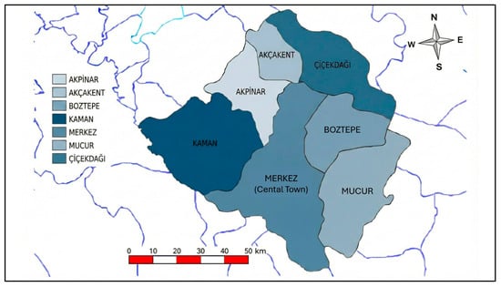
Figure 1.
Boundary Map of Kırşehir Province [12].
Previous research has also shown that mechanization levels in Kırşehir increased substantially following LC activities. Reductions in parcel number per enterprise, improved field accessibility, and better road networks have contributed to enhanced tractor utilization, reduced fuel consumption, and more effective use of agricultural implements [8,10,11].
Overall, Kırşehir provides a representative case of rural regions in Central Anatolia undergoing structured transformation through government-led land consolidation. Its agricultural landscape, mechanization characteristics, and long-term LC implementation make it a suitable setting for evaluating how parcel restructuring influences agricultural mechanization efficiency.
2.2. Data Collection
The data used in this study were obtained from a combination of official institutional records, national statistical databases, cadastral archives, project documentation, and field-based observations. Integrating multiple sources ensured high reliability, accuracy, and comprehensive coverage of both structural and mechanization-related variables associated with land consolidation (LC) in Kırşehir Province between 2010 and 2022.
- Turkish Statistical Institute (TURKSTAT)
Annual agricultural statistics obtained from TURKSTAT included key mechanization indicators such as:
-Number of tractors;
-Tractor density (tractors per 1000 ha);
-Cultivated area per tractor;
-Tractor power (kW/ha);
-Number of implements per tractor.
These long-term indicators (2010–2022) formed the primary quantitative basis for analyzing mechanization trends [14].
- General Directorate of Agricultural Reform (GDAR)
GDAR provided project-level documentation related to LC initiatives in Kırşehir, including information on consolidated area size, project boundaries, initiation and completion dates, and participating villages. These records were essential for linking LC implementation timelines with corresponding changes in parcel structure and mechanization indicators [17].
- Land Registry and Cadaster General Directorate (TKGM)
Historical cadastral maps and parcel registry records were obtained from TKGM to examine pre- and post-LC spatial configurations. These datasets enabled visual assessment of parcel size, geometric regularity, and fragmentation patterns before and after consolidation, supporting the analysis of structural improvements [18].
- State Hydraulic Works (DSİ)
DSİ supplied technical project documentation, implementation reports, and village-level consolidation statistics. These records were particularly useful for verifying project boundaries, confirming implementation periods, and cross-validating the spatial distribution of consolidated areas across the province [16].
- Field-Based Data
Field observations and historical LC records maintained by local administrative units were incorporated to capture qualitative insights. These included data on machinery use patterns, land accessibility, operational field constraints, and mechanization conditions after consolidation. Such qualitative findings complemented institutional datasets and helped contextualize the practical implications of LC on farm operations.
- Geographic Information System (GIS) Data
GIS-based processing was employed to organize, analyze, and visualize spatial data regarding parcel boundaries and LC project extents. The cadastral maps used in this study were non-scaled (scale-free) and thus served primarily as visual aids rather than sources for quantitative spatial measurement. Nevertheless, they provided valuable evidence of improvements in parcel geometry and field accessibility following LC [18].
The integration of these diverse datasets enabled a robust longitudinal evaluation of agricultural mechanization before and after land consolidation across Kırşehir between 2010 and 2022.
Table 1 presents the temporal trends in mechanization indicators, including:
-Number of tractors;
-Tractor density;
-Cultivated area per tractor;
-Tractor power per hectare;
-Implements per tractor.
Table 2 summarizes pre- and post-consolidation values for these indicators, highlighting the magnitude and direction of structural and operational changes attributable to LC and providing a basis for evaluating improvements in mechanization efficiency in the province.

Table 1.
Mechanization Indicators in Kırşehir Province (2010–2022).
Table 1.
Mechanization Indicators in Kırşehir Province (2010–2022).
| Year | Number of Tractors | Cultivable Area (1000 ha) | Tractors per 1000 ha | Implements per Tractor |
|---|---|---|---|---|
| 2010 | 8066 | 397.71 | 20.28 | 5 |
| 2011 | 10,080 | 413.49 | 24.37 | 4 |
| 2012 | 8062 | 399.68 | 20.17 | 5 |
| 2013 | 7381 | 384.53 | 19.19 | 6 |
| 2014 | 7461 | 366.29 | 20.37 | 6 |
| 2015 | 7500 | 391.66 | 19.15 | 6 |
| 2016 | 7837 | 397.52 | 19.71 | 6 |
| 2017 | 7866 | 352.58 | 22.31 | 6 |
| 2018 | 7915 | 350.10 | 22.61 | 6 |
| 2019 | 7972 | 325.00 | 24.53 | 6 |
| 2020 | 11,728 | 327.60 | 35.80 | 4 |
| 2021 | 10,994 | 326.50 | 33.67 | 4 |
| 2022 | 12,072 | 331.67 | 36.40 | 4 |
Note: Data obtained from Turkish Statistical Institute [14].
Table 2.
Key Mechanization Indicators Before and After Land Consolidation.
Table 2.
Key Mechanization Indicators Before and After Land Consolidation.
| Indicator | 2010 (Before LC) | 2022 (After LC) | % Change |
|---|---|---|---|
| Average Parcel Size (ha/farm) | 2.4 | 6.8 | +183% |
| Tractor Density (tractors/1000 ha) | 20.28 | 36.40 | +79.5% |
| Tractor Power (kW/ha) | 0.09 | 0.16 | +77.8% |
| Implements per Tractor | 5 | 4 | −20% |
| ha per Tractor | 49.3 | 27.5 | −44% |
Note: “Before LC” values correspond to 2010 baseline data; “After LC” values correspond to 2022 data. LC = Land Consolidation. Average parcel size increased from 2.4 ha/farm to 6.8 ha/farm (+183%).
2.3. Analysis Methods
2.3.1. Evaluation of Parcel Size Changes
To assess the structural effects of land consolidation (LC) on agricultural land, changes in average parcel size (ha/farm) were analyzed by comparing pre-consolidation and post-consolidation periods. Parcel boundary information was obtained from the Land Registry and Cadaster General Directorate (TKGM), which provided digitized cadastral archives, historical parcel maps, and registry records for both periods [18].
For each period, the mean parcel size was calculated, and the percentage change was derived to quantify the degree of structural improvement attributable to LC. Parcel size is widely recognized as a key determinant of mechanization efficiency, operational field performance, and land-use optimization, and similar metrics have been used in previous evaluation studies [7,8,9,17].
The results summarizing changes in parcel size before and after LC implementation are presented in Table 2, providing a clear depiction of improvements in parcel geometry and land distribution.
2.3.2. Statistical Comparison of Mechanization Indicators
To evaluate the relationship between land consolidation and agricultural mechanization, three core mechanization indicators were examined across the study period:
Parcel size (ha/farm);
Tractor density (tractors per 1000 ha);
Number of implements per tractor.
These indicators were selected based on their widespread use in assessing mechanization capacity, field accessibility, operational efficiency, and investment level in agricultural machinery [8,9,16].
Descriptive statistics were employed to examine temporal patterns in mechanization indicators between 2010 and 2022. To determine whether the observed differences between pre-consolidation and post-consolidation values were statistically significant, a paired t-test was conducted for each indicator. The paired t-test is a widely accepted method in agricultural and mechanization research, particularly for analyzing longitudinal datasets and field-level mechanization metrics [3,19].
The statistical results—mean values, t-statistics, and p-values—are presented in Table 3, providing evidence of whether LC influenced mechanization indicators in a statistically meaningful way.
Table 3.
Statistical Results of Paired t-test for Mechanization Indicators Before and After Land Consolidation.
2.4. Statistical Testing Framework
To evaluate the effects of land consolidation on mechanization indicators, statistical analyses were performed using paired t-test procedures, comparing pre-consolidation and post-consolidation values for each variable. The paired t-test was selected because it is widely used for longitudinal agricultural datasets and for assessing the impact of structural interventions such as LC, where repeated measurements are taken for the same unit over time [3,19].
Prior to conducting the paired t-tests, descriptive statistics were examined to verify data suitability, and normality assumptions were evaluated through distributional checks. Each mechanization indicator—parcel size, tractor density, tractor power per hectare, and number of implements per tractor—was analyzed to determine whether observed changes were statistically significant.
The statistical hypotheses guiding the evaluation were defined in the Introduction and are summarized as follows:
- H0 (Null Hypothesis): Land consolidation has no statistically significant effect on mechanization indicators in the study area.
- H1 (Alternative Hypothesis): Land consolidation significantly improves mechanization indicators, including tractor density, tractor power per hectare, cultivated area per tractor, and number of implements per tractor.
The outputs of the paired t-tests—including mean differences, t-statistics, degrees of freedom, and p-values—are presented in Table 3, providing empirical evidence regarding the extent to which LC produced measurable improvements in mechanization efficiency.
3. Results
The results of this study focus on the effects of land consolidation on key agricultural mechanization indicators in Kırşehir Province, including parcel structure, tractor density, tractor power, and the number of implements per tractor.
3.1. Changes in Parcel Structure
Land consolidation led to substantial improvements in parcel structure across the study area.
The impacts of these structural changes are illustrated in Figure 2, which shows the cadastral layout of Karaduraklı Village before and after consolidation.
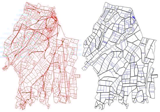
Figure 2.
Cadastral parcel layouts in Karaduraklı Village, Kırşehir Province, before and after land consolidation (Note: The map is not to scale and is used solely for visual comparison; approximate scale ≈ 1:5000).
The cadastral maps clearly demonstrate the transformation of land structure following consolidation. The number of parcels decreased significantly, while parcels became larger, more rectangular, and more regularly shaped, reducing fragmentation and improving field accessibility. Similar structural improvements following LC have also been widely documented in previous research [1,2,5,20,21].
Similar improvements were observed in other villages such as Yeşilli and Büyükkobak.
These structural changes provided a more suitable physical environment for modern agricultural machinery. Larger and regularly shaped parcels reduced turning frequency, field boundaries, and operational complexity, which is consistent with findings emphasizing that parcel enlargement enhances mechanization efficiency [7,8,9,11,22].
The cadastral maps clearly demonstrate the transformation of land structure following consolidation. The number of parcels decreased significantly, while parcels became larger, more rectangular, and more regularly shaped, reducing fragmentation and improving field accessibility. Similar improvements were observed in other villages such as Yeşilli and Büyükkobak.
These structural changes provided a more suitable physical environment for modern agricultural machinery. Larger and regularly shaped parcels reduced turning frequency, field boundaries, and operational complexity, consistent with previous findings in the literature [21].
3.2. Temporal Trends in Mechanization Indicators (2010–2022)
The temporal evolution of mechanization indicators between 2010 and 2022 is summarized in Table 1, which provides a comprehensive overview of long-term trends in tractor numbers, cultivated area, tractor density, and implement ownership in Kırşehir Province. Such long-term mechanization trends have also been emphasized in previous regional and international studies [8,9,10,16].
Between 2010 and 2016, tractor density rose from 20.28 to approximately 24–25 tractors per 1000 ha, indicating a gradual increase in mechanization intensity. During this period, the number of parcels remained high, and cultivated land area decreased due to fragmentation, land abandonment, and operational inefficiencies—patterns similarly noted in earlier LC and rural restructuring studies [1,5,23].
Between 2017 and 2022, tractor density increased sharply from 27.00 to 36.40 tractors per 1000 ha, despite fluctuations in cultivated land area. This sharp rise reflects the combined effects of improved parcel geometry, reduced fragmentation, and strengthened machinery investment following LC, consistent with findings reported in previous empirical studies [8,19,20].
Tractor power per hectare also increased substantially—from 0.09 kW/ha in 2010 to 0.16 kW/ha in 2022—indicating a transition toward more powerful and modern machinery. Similar mechanization shifts have been documented in both national and international agricultural systems following structural improvements in landholding patterns [9,10,16,24].
Conversely, the number of implements per tractor declined from 5–6 to 4, suggesting more efficient implement utilization and greater specialization in machinery use. Previous mechanization efficiency studies have linked such trends to reductions in redundancy and improvements in machinery–farm size alignment [7,9,22,25].
3.3. Comparison of Mechanization Indicators Before and After Consolidation
A direct comparison of pre- and post-consolidation indicators is presented in Table 2.
The results show substantial improvements following land consolidation:
- Average parcel size increased by +183%.
- Tractor density increased by +79.5%.
- Tractor power per hectare increased by +77.8%.
- Implements per tractor decreased by −20%, indicating more efficient use of machinery.
- Cultivated area per tractor decreased by −44%, showing better operational efficiency.
These findings demonstrate that land consolidation not only reorganized parcel structures but also enhanced the efficiency of machinery operations, supporting more intensive and effective mechanization.
3.4. Statistical Validation of Pre- and Post-Consolidation Differences
The statistical significance of changes in mechanization indicators was tested using paired t-tests across 2010 and 2022 values. The results are presented in Table 3.
All mechanization indicators showed statistically significant differences (p < 0.05) between pre- and post-consolidation periods.
These results confirm that the observed improvements are not random but directly attributable to land consolidation.
4. Discussion
The findings of this study demonstrate that land consolidation (LC) in Kırşehir Province generated substantial improvements in both parcel structure and agricultural mechanization efficiency. The transition from fragmented, irregular parcels to larger and more geometrically coherent plots directly enhanced machinery maneuverability, reduced operational field losses, and improved field accessibility. Similar outcomes have been documented in earlier LC applications in Lithuania, Poland, China, and Vietnam, where consolidation significantly reduced fragmentation, minimized machinery turning losses, and increased the feasibility of using higher-capacity equipment [1,5,9,10,11,20,26]. The present study confirms these trends for Türkiye and provides long-term empirical evidence that structural improvements are strongly associated with measurable gains in mechanization.
A key contribution of this research is the integration of long-term mechanization indicators (2010–2022) with cadastral transformations, enabling a combined assessment that is rarely presented in previous LC literature. Many international studies evaluate land structure and mechanization separately; however, the analytical approach adopted here reveals clear causal linkages between structural reorganization and mechanization performance [7,9,19,22,23]. The statistically significant increases in tractor density and tractor power per hectare, accompanied by declines in implements per tractor and cultivated area per tractor, indicate a shift toward more capital-intensive, technology-driven production systems. These findings reinforce the notion that physical land restructuring can accelerate rural technological modernization, a concept previously supported in case studies from Asia and Europe [9,10,11,12,24].
The results also highlight several context-specific characteristics of mechanization development in Türkiye. In many European countries, improvements in mechanization tend to evolve gradually as a function of farm-level investment behavior and land market dynamics. In contrast, Kırşehir experienced rapid parcel restructuring and sharp mechanization gains within a relatively short post-consolidation period. This accelerated transformation may be attributed to Türkiye’s targeted LC policies, which prioritize reducing fragmentation in large agricultural basins, integrate irrigation infrastructure, and promote machinery use through national support mechanisms [14,15,16,17,21]. Such policy alignment likely amplified the positive LC impacts observed in this study and distinguishes Türkiye’s consolidation trajectory from those of regions where institutional support is weaker.
Despite the demonstrated benefits, the analysis has certain limitations. First, pre-consolidation parcel measurements were not available in complete numerical form for all villages, necessitating partial reliance on visual interpretation of cadastral maps—a limitation also noted in earlier LC studies using historical mapping sources [13,22]. Second, the study focuses exclusively on structural and mechanization indicators; socio-economic variables such as farmer income, labor availability, financial constraints, and machinery investment capacity were not included but may significantly influence mechanization outcomes [4,11]. Third, although parcel restructuring patterns were broadly consistent across the study area, only one village-level cadastral map could be presented with sufficient clarity due to scale limitations. Future research may incorporate high-resolution GIS datasets, farmer-level surveys, and multi-regional analyses to enhance representativeness and generalizability [2,10,18,19].
Overall, the study’s findings underscore that land consolidation plays a pivotal role in improving the efficiency, sustainability, and technological capacity of agricultural systems. By reducing fragmentation, enhancing parcel geometry, and enabling more effective machinery operation, LC establishes a structural foundation that supports modern production practices. These outcomes provide valuable guidance for policymakers seeking to design integrated land and mechanization strategies in Türkiye and in other regions facing similar structural constraints [1,5,9,11,26].
5. Conclusions
This study provides one of the few longitudinal empirical assessments examining the combined effects of land consolidation on parcel restructuring and agricultural mechanization efficiency in Türkiye. By integrating cadastral parcel records with long-term mechanization indicators covering the period 2010–2022, the analysis demonstrates that land consolidation produced measurable and meaningful improvements in both land structure and machinery utilization. Parcel fragmentation decreased markedly, average parcel size increased, and overall parcel geometry became more regular—structural outcomes that align with international evidence showing that LC enhances field accessibility and reduces operational inefficiencies [1,5,9,10,11].
Mechanization indicators exhibited similarly positive trends. Tractor density increased substantially, tractor power per hectare nearly doubled, and cultivated area per tractor declined, indicating more efficient machinery deployment. The paired t-test results confirmed that these changes were statistically significant, supporting the conclusion that mechanization gains cannot be explained by random variation or external trends alone but are directly attributable to consolidation processes. Comparable relationships between improved land structure and mechanization performance have been reported in earlier studies across Europe and Asia [8,9,20,22].
These findings underscore the importance of integrating land reform initiatives with broader rural mechanization strategies. Land consolidation not only restructures agricultural landscapes but also creates the structural conditions necessary for adopting higher-capacity machinery, reducing field losses, and enabling more sustainable production practices. As several studies emphasize, the alignment of LC programs with mechanization support policies can accelerate rural development and technological modernization [15,16,17,22,25]. Policymakers may therefore prioritize consolidation efforts in regions where fragmented land structures continue to limit mechanization, productivity, and resource-use efficiency.
Future research could extend this work by incorporating socio-economic variables—such as farm income, labor supply, machinery investment behavior, and technology adoption patterns—which were beyond the scope of the present analysis but may significantly influence mechanization outcomes. Additionally, integrating high-resolution GIS datasets and multi-regional comparisons would enhance understanding of spatial restructuring effects and improve generalizability, as suggested in recent LC and rural transformation literature [2,9,10,13,18,19].
Overall, the study provides robust evidence that land consolidation acts as a catalyst for sustainable agricultural development in Türkiye by simultaneously improving parcel structure and strengthening mechanization efficiency. These insights offer a valuable foundation for designing integrated land-use and mechanization policies in regions facing similar structural constraints [1,5,9,27].
Author Contributions
Conceptualization, B.A. and G.Ö.E.; methodology, B.A.; formal analysis, B.A.; investigation, B.A.; resources, B.A.; data curation, B.A.; writing—original draft preparation, B.A.; writing—review and editing, G.Ö.E.; supervision, G.Ö.E. All authors have read and agreed to the published version of the manuscript.
Funding
This research received no external funding.
Institutional Review Board Statement
Not applicable.
Informed Consent Statement
Not applicable.
Data Availability Statement
The data presented in this study are available in the thesis document and upon reasonable request from the corresponding author.
Acknowledgments
This study is based on the Master’s Thesis of Bircan Alkan, conducted as part of the Biosystems Engineering Department at the Graduate School of Natural and Applied Sciences, Kırşehir Ahi Evran University. The authors would like to thank the faculty members and staff of the department for their support and guidance throughout the research process.
Conflicts of Interest
The authors declare no conflicts of interest.
References
- Küsek, G. Türkiye’de Arazi Toplulaştırmasının Yasal Durumu ve Tarihsel Gelişimi. Ç.Ü.Z.F. Dergisi 2014, 29, 1–6. [Google Scholar]
- Irmakli, P.G.; Aydin, A. Contribution of Land Consolidation to Agriculture and Agricultural Mechanization: Çanakkale-Biga-Dereköy Example. Tekirdağ Ziraat Fakültesi Derg. 2022, 19, 582–599. [Google Scholar] [CrossRef]
- Varga, V.; Bažík, J. Land Consolidation as an Useful Tool for Rural Development. 2013. Available online: https://scispace.com/pdf/land-consolidation-as-an-useful-tool-for-rural-development-226h5i3f3e.pdf (accessed on 25 April 2025).
- Zhang, N.; Zhang, X.; Xiu, C. Does Agricultural Mechanization Help Farmers to Strengthen Sustainability and Protect Cultivated Land? Evidence from 2118 Households in 10 Provinces of China. Sustainability 2024, 16, 6136. [Google Scholar] [CrossRef]
- Küsek, G. Arazi Toplulaştırmasının Arazi Parçalılığı ve İşletme Ölçeğine Etkileri: Konya-Ereğli-Kuskuncuk Köyü Örneği. Ç.Ü.Z.F. Dergisi 2014, 29, 15–28. [Google Scholar]
- Kaplan, E.; Bal, H. Assessing the Land Consolidation Projects from the Perspective of Farmers (A Case Study in Artova District of Tokat Province in Turkey). Turk. J. Agric. Food Sci. Technol. 2021, 9, 1775–1781. [Google Scholar] [CrossRef]
- Evcim, H.Ü.; Özgünaltay Ertuğrul, G. Türkiye Tarımında Traktör Kullanımı (2010). Tarım Makinaları Bilim. Derg. 2017, 13, 21–31. [Google Scholar]
- Maklavani, F.H.; Parashkoohi, M.G.; Zamani, D.M.; Afshari, H. Investigating the impact of integrating land consolidation with agricultural mechanization on the technical, energy, and environmental dimensions of paddy production. J. Agric. Eng. 2025, 56, 1721. [Google Scholar] [CrossRef]
- Chen, X.; Lin, C.; Hou, X.; Wu, Z.; Yan, G.; Zhu, C. The impact of land consolidation on arable land productivity: A differentiated view of soil and vegetation productivity. Agric. Ecosyst. Environ. 2022, 326, 107781. [Google Scholar] [CrossRef]
- Demirdogen, A. Land consolidation, cropland use, and vegetation productivity. Agribusiness 2024, 41, 719–737. [Google Scholar] [CrossRef]
- Ge, X.; Zhu, F.; Yang, Y.; Liu, G.; Chen, F. Probing Influence Factors of Implementation Patterns for Sustainable Land Consolidation: Insights from Seventeen Years of Practice in Jiangsu Province, China. Sustainability 2020, 12, 3576. [Google Scholar] [CrossRef]
- Özgünaltay Ertuğrul, G.; Ertuğrul, O.; Değirmencioğlu, A. Determination of Agricultural Mechanization Level of Kırşehir Province Using Geographical Information Systems (GIS). Comptes Rendus L’académie Bulg. Sci. 2019, 728, 1144–1150. [Google Scholar]
- Özgünaltay Ertuğrul, G. İç Anadolu Bölgesi’nde Traktörlerin Yıllık Kullanım Sürelerinin Analizi: Kırşehir ve Yozgat Örneği. ISPEC J. Agric. Sci. 2025, 9, 703–711. [Google Scholar]
- Turkish Statistical Institute (TURKSTAT). Agricultural Mechanization Statistics, Tractor and Farm Size Data; Turkish Statistical Institute (TURKSTAT): Ankara, Türkiye, 2022. [Google Scholar]
- Turkish Meteorological Service. Climate Data for Kırşehir. 2023. Available online: https://www.mgm.gov.tr/Veridegerlendirme/il-ve-ilceler-istatistik.aspx?k=&m=KIRSEHIR (accessed on 5 October 2025).
- State Hydraulic Works (DSİ). Land Consolidation Project Data for Kırşehir Province; Unpublished Internal Report; General Directorate of State Hydraulic Works: Ankara, Türkiye, 2024. [Google Scholar]
- General Directorate of Agricultural Reform (GDAR). Reports on Land Consolidation Projects in Kırşehir; Ministry of Agriculture and Forestry: Ankara, Türkiye, 2024. [Google Scholar]
- Land Registry and Cadastre General Directorate (TKGM). Cadastral Maps and Parcel Records Before and After Consolidation; Ministry of Environment, Urbanization and Climate Change: Ankara, Türkiye, 2024. [Google Scholar]
- Nguyen, H.Q.; Warr, P. Land consolidation as technical change: Economic impacts in rural Vietnam. World Dev. 2020, 127, 104750. [Google Scholar] [CrossRef]
- Gundogdu, K.S.; Aslan, A.; Kirmikil, M. Land Consolidation and Agricultural Sustainability in Turkey. In Proceedings of the International Conference on Sustainable Agriculture, Stuttgart, Germany, 17–19 September 2013. [Google Scholar]
- Long, H. Land consolidation: A way of rural restructuring and vitalization. In Land Use Transitions and Rural Restructuring in China; Springer: Singapore, 2020; pp. 473–490. [Google Scholar]
- Yamashita, R.; Morisawa, K. Consideration of Qualitative Changes in Agricultural Settlements Due to Land Consolidation. Int. Rev. Spat. Plan. Sustain. Dev. 2020, 8, 124–136. [Google Scholar] [CrossRef] [PubMed]
- Lisec, A.; Pintar, M. Conservation of natural ecosystems by land consolidation in the rural landscape. Acta Agric. Slov. 2005, 85, 73–82. [Google Scholar] [CrossRef]
- Amongo, R.; Larona, M.; Onal, M.; Resurreccion, A.; Lalap, G.; Limbo, M. Land Consolidation for Sustainable Crop Production for the Agro-Industry. IOP Conf. Ser. Earth Environ. Sci. 2021, 733, 012023. [Google Scholar] [CrossRef]
- Ertuğrul, G.Ö.; Değirmencioğlu, A. A GIS- Based Approach on Annual Tractor Use, Soil Type and Crop Pattern Interactions in Some Provinces of the Aegean Region. Turk. J. Agric.-Food Sci. Technol. 2021, 9, 1384–1389. [Google Scholar] [CrossRef]
- Taniyama, S. Land Consolidation in Paddy Fields. J. Agric. Eng. 1975, 9, 291–298. [Google Scholar]
- Leń, P.; Maciąg, M.; Siejka, M.; Maciąg, K.; Kocur-Bera, K.; Rapiński, J. A New Method for Assessing Land Consolidation Urgency, including Market Value. Sustainability 2024, 16, 835. [Google Scholar] [CrossRef]
Disclaimer/Publisher’s Note: The statements, opinions and data contained in all publications are solely those of the individual author(s) and contributor(s) and not of MDPI and/or the editor(s). MDPI and/or the editor(s) disclaim responsibility for any injury to people or property resulting from any ideas, methods, instructions or products referred to in the content. |
© 2025 by the authors. Licensee MDPI, Basel, Switzerland. This article is an open access article distributed under the terms and conditions of the Creative Commons Attribution (CC BY) license (https://creativecommons.org/licenses/by/4.0/).