Abstract
This study shows that an integrated ecological and cultural corridor network can help guide city development strategies to better preserve ecological and cultural assets. Traditionally, protection zones and suitable development areas are often identified by separately considering natural elements of the ecosystem and elements of cultural significance. To achieve the purpose of cohesively protecting areas of ecological and/or cultural significance, we have developed a corridor-based spatial framework by integrating ecological and cultural assets. Ecological sources are identified by combining protection prioritization, nature reserves, and water bodies. Ecological corridors are delineated by using the minimum cumulative resistance (MCR) model on a resistance surface constructed from land-use data to connect ecological sources. Ecologically important areas are then delineated by creating a 5-km buffer zone from ecological sources and ecological corridors. Cultural corridors are historical routes and rivers surrounded by abundant cultural nodes. Like ecologically important areas, culturally important areas are delineated by creating a 5-km buffer zone from cultural corridors. Comprehensive regions are the overlap of ecologically and culturally important areas. Finally, the integrated network connects all comprehensive regions following ecological corridors and cultural corridors in such a way that the largest number of ecological sources and cultural nodes are reached. We applied this framework in Beijing, China, and the results show that there are 2011 km2 of ecological sources, 30 ecological corridors, 423 cultural nodes, seven cultural corridors, and 10 comprehensive regions covering 2916 km2 in the integrated network. The framework adds new insights to the methodology of considering ecological and cultural assets together in developing protection and development strategies.
1. Introduction
Human settlements have evolved from a cluster of cities to metropolitan areas, metropolitan area belts, large metropolitan belts, and megalopolises [1]. The world population has increased exponentially under this massive urbanization. In 2019, the United Nations predicted that the world population will have increased to 9.7 billion by 2050 and 66% of the population will reside in urban areas [2]. The conflicts between economic development and ecological protection have been seriously exacerbated by the rapid and intense changes in the structure and function of the landscape [3,4]. The rapid influx of popular culture from developed countries into developing countries and the widespread homogeneity of cultural practices have marginalized or even led to the disappearance of many indigenous cultures. These factors are the cause of many serious problems in the world today, such as air and water pollution, cultural invasion, biodiversity loss, food insecurity, and rising crime rates. Some scholars have pointed out that the world and its constituent landscapes are on an unsustainable trajectory. The question of how to reduce the effects of urbanization on the ecosystem in order to achieve urban sustainability has become an important focal point in the field of landscape ecology [5,6,7,8]. Sustainable development is a necessity, not a choice [9].
To achieve sustainable development, human beings must be in harmony with the environment in which they live. Ecosystem services are one of the important factors determining landscape sustainability. Among various definitions of ecosystem services [10,11,12,13], the most widely accepted is from the Millennium Ecosystem Assessment: ecosystem services are the benefits people obtain from ecosystems. Ecosystem services have been increasingly considered a crucial bridge between the environment and society, which also safeguard the natural capital for future generations and highlight the contributions of ecosystems to human wellbeing [14,15,16]. Although ecosystem service evaluation has received increasing attention over the years [17], most studies still use biodiversity conservation, ecological importance, ecological risk evaluation, and resilience assessment to recognize ecological sources when delineating ecological corridors [18,19].
Similar to how modern material civilization comes at the expense of biological diversity, modern spiritual civilization comes at the expense of cultural diversity. With industrialization and human expansion, the earth is losing its biological and cultural diversity. The influence of foreign cultures, the transformation of traditional lifestyles, the mobility of the population, and the over-exploitation of tourism have destroyed various intangible cultural heritage resources. Many cultural heritage resources are the products of the long-term interaction between human beings and the natural environment in indigenous societies, which can enable people to recover the memory of the past and to build new perspectives [20]. However, many ancient buildings, bridges, and other facilities are gradually being replaced by works of modern engineering, and numerous excellent cultural heritage sites are scattered and lack contact with each other, which causes them to disappear over time. It is extremely urgent to establish an integrated conservation strategy to breathe new life into these precious assets.
As for the protection of ecological and cultural resources, inclined research on ecological/cultural conservation strategies focused on the establishment and application of corridors system to solve the relationship between protection and development comprehensively and efficiently [20,21,22,23,24,25]. In fact, Lewis (1964) put forward the linear concept of “environmental corridor” earlier, which contains surfaces, slopes, rims, and adjacent lands paralleling the corridor. The author also pointed out that the protection of environmental corridor qualities needs the joint efforts of better guidelines, legislation, and volunteered participation, and these corridors can serve as a landscape foil to an ever-advancing urban landscape [26]. Nevertheless, ecological or cultural corridors were always concerned separately rather than simultaneously. The aim of most ecological corridors is to maximize the value of regulating ecosystem services and biodiversity conservation by enhancing the connectivity among landscape elements [27,28], while recreation and tourism, sense of place, and heritage protection are the main functions of cultural corridors [23,29]. The aims, problems addressed, managing approaches, and spatial scale of these two aspects all have significant differences, and the scientific research, management practice and political discourses of ecological conservation and cultural heritage protection have largely been isolated from each other [30]. The participation of local residents is far lower than that of government decision-makers in the planning and management of both ecological corridors and cultural corridors, but the stakeholders and participation manners involved are quite different [30,31]. The combination of ecological corridors and cultural corridors is quite necessary to enrich the study framework and improve spatial integrity.
In this study, we address a few important gaps in the knowledge: (1) in the context of rapid urbanization, which leads to the disappearance of indigenous cultures and ecologically sensitive areas, comprehensive research on the combination of the ecological corridor and cultural corridor is not enough, and (2) current protection studies and practices of ecologically sensitive sites and cultural sites are not linked. We have designed this study to: (1) construct an integrated ecological and cultural corridor-based framework, (2) establish protection priorities by integrating protection values and protection costs, and (3) provide a scientific reference for optimizing the ecological spatial structure and promoting regional sustainable development. The rest of the paper is organized as follows. In Section 2, we describe the study area and our integrated framework. The application of the framework is presented in Section 3. In Section 4, we discuss our findings, and in Section 5, we summarize our conclusions.
2. Materials and Methods
2.1. Study Area
The study region, i.e., the city of Beijing (16,410 km2), is located in Northern China and is characterized by a variety of landforms and a rich cultural history. The terrain of Beijing slopes downwards from the northwest to the southeast (Figure 1). The city’s average population density was 1313 person/km2, and the population density of the central urban area was 8929 person/km2 in 2018. Along with rapid urbanization, the area of developed land dramatically increased from 485 km2 in 1990 to 1525 km2 in 2018. As a famous historical and cultural city, Beijing has hundreds of key cultural relic protection units, including 6 world heritage sites, such as the Great Wall and the Forbidden City.
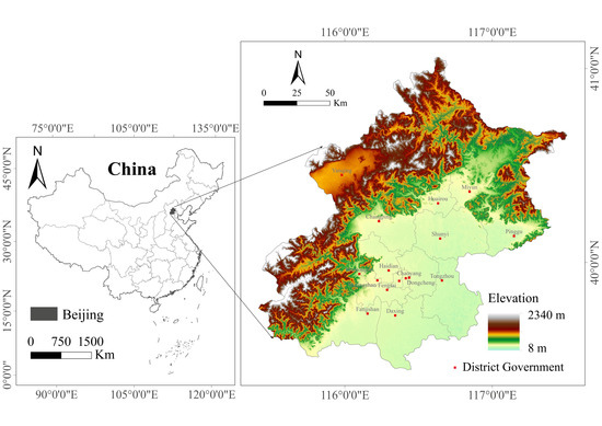
Figure 1.
Location of Beijing and its Digital Elevation Model (DEM).
2.2. Data and Data Sources
The data used in this research include: (1) digital elevation model (DEM) data with a spatial resolution of 30 m, (2) land cover raster data with a spatial resolution of 30 m, which is reclassified into 6 types: developed land, forest land, farmland, grassland, water bodies, and unused land, (3) railroads, highways, and national roads in vector data format, (4) water bodies including rivers, lakes, and reservoirs in vector data format, (5) normalized difference vegetation index (NDVI) raster data with a spatial resolution of 1 km, which is resampled to 30 m, (6) the monthly and annual average precipitation of 18 weather stations from 1980 to 2012 in tabular data format, and among these weather stations, there are 6 in Beijing and 12 around Beijing, which can increase the accuracy of created raster in edge area, (7) soil composition and soil texture raster data with a spatial resolution of 1 km, which is resampled to 30 m, (8) nature reserves in vector data format, and (9) cultural heritage in vector data format. The spatial resolution of 30 m is used in all the raster calculations and outcomes. Appendix A Table A1 lists the data and data sources.
2.3. Methodological Framework
Figure 2 illustrates the conceptual framework of delineating the integrated network from ecological corridors and cultural corridors. Identifying ecological sources is the first step in delineating ecological corridors. Ecological sources consist of nature reserves, water bodies, and areas of high protection priority. Factors affecting the protection priority can be grouped into protection values and protection costs. Protection values reflect health and vulnerability, ecological importance, and the existing protection status of the targets [32,33]. Land use types, soil properties, and surface environment affect the ability to maintain biological resources and protection value. In this study, these factors were used in the process of deriving protection values from the amount of soil conservation. All protection interventions have associated costs, which include acquisition costs, management costs, transaction costs, damage costs, and opportunity costs, and protection costs are affected by many factors [34,35,36,37]. In this study, we included elevation (ELE), proximity to settlements (PSE), proximity to roads (PRO), and proximity to water bodies (PWA) in calculating the protection costs. Then, taking the protection costs as the resistance surface, paths connecting ecological sources were delineated as ecological corridors using the minimum cumulative resistance (MCR) model. When delineating cultural corridors, we considered designated cultural heritage sites to be cultural nodes. Since many cultural nodes are located along rivers and historical routes, we derived cultural corridors from the spatial distribution characteristics of cultural nodes and historical routes and rivers that have cultural and historical significance. Through a buffer analysis of the ecological sources and ecological corridors, ecologically important areas were obtained. Culturally important areas were acquired through a buffer analysis of cultural corridors. Then, ecologically important areas and culturally important areas were superimposed to obtain the comprehensive regions. Finally, the integrated network was delineated to connect the ecological sources, cultural nodes, ecological corridors, cultural corridors, and comprehensive regions.
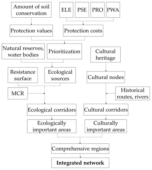
Figure 2.
The framework for developing the integrated network.
2.4. Delineation of Ecological Corridors
2.4.1. Identification of Ecological Sources
We derived protection values from the amount of soil conservation. The function of soil conservation is mainly related to climate, soil characteristics, topography, and vegetation. We used the revised universal soil loss equation (RUSLE) to calculate the amount of soil conservation in this study. RUSLE, proposed by Renard, is the most frequently used model [34,38]. It provides an ideal framework for assessing soil erosion and a clear perspective for understanding the interaction between erosion and its contributing factors. The model and its parameters are illustrated below.
where A is the amount of soil conservation (t∙ha−1∙year−1), A0 is the amount of potential soil loss, and A1 is the amount of actual soil erosion loss. Other factors are explained as below:
- (1)
- R represents the erosivity factor (MJ∙mm∙ha−1∙h−1∙year−1), which is calculated by monthly precipitation and annual precipitation.where Pi (mm) is the average precipitation of month i and P (mm) represents the multi-year average precipitation. We converted punctuated weather station data into raster data using the inverse distance weighted (IDW) tool in ArcGIS 10.5.
- (2)
- K represents the soil erodibility factor calculated from the soil content (t∙h∙MJ−1∙mm−1).where SAN, SIL, CLA, and orgC represent the proportion of sand, silt, clay, and organic carbon in the soil respectively, SN1 = 1 − SAN/100.
- (3)
- L represents the slope length factor.where λ is slope length, m is slope length index, and θ is slope measured in percentage.
- (4)
- S represents the slope steepness factor.
- (5)
- C is the vegetation cover management factor.where c is vegetation coverage, and NDVIsoil and NDVIveg are the values of NDVI when the confidence level is 5% and 95%, respectively.
- (6)
- P is the support practices factor, which is a ratio of the soil loss with a conservation practice to soil loss from straight-row farming up and down the slope [39]. We used a P factor value of 1 in the study.
We normalized A into five classes using the Jenks Natural Breaks Classification method. The five class values represent the protection value (Pv). A Pv of “5” indicates the highest protection value and “1” the lowest. We derived the composite protection costs from elevation (ELE), proximity to settlements (PSE), proximity to roads (PRO), and proximity to water bodies (PWA). In China, land is state-owned or collective owned, and there are 2 types of costs due to conservation: the management cost of direct investment in the establishment and management of protection facilities, and the opportunity cost of abandoning the potential value of land economic use [40]. Management cost is mainly related to the type, area and local economic factors of the reserves [41]. Therefore, the 4 indicators related to elevation and distance in our study mainly affect the opportunity cost. Land in higher elevation areas is less desirable for development and less likely to be used for other economic purposes. Therefore, the opportunity cost is lower. The edge of settlements has a high probability of being used to build housing or other developments, so the opportunity cost lost due to conservation measures decreases as the distance to settlements increases. Roads can cause habitat fragmentation and ecosystem degradation, and land proximity to roads means it is potentially valuable for other economic use, so the opportunity cost is high near roads and decreases as the distance increases from roads. Considering the isolation effect of roads on ecological space, we selected the highways, national roads, and railroads in this study. Surface water bodies have a function of conserving water sources, but waterfronts are usually places of human activity. Therefore, the larger the distance from water bodies, the lower the opportunity cost. We used the “Euclidean Distance” tool in ArcGIS 10.5 to obtain the PSE, PRO, and PWR, then we reclassified these indicators to values from “1” to “5” and calculated the protection cost (Pc) as the weighted sum of them (the natural breakpoint method was used to perform the reclassification in this paper). The weights of ELE, PSE, PRO, and PWA are 0.3564, 0.3257, 0.1986, 0.1243 respectively, according to the research of Tao [42]. The protection cost, Pc, was reclassified to five discrete values, with “5” indicating the lowest protection cost and “1” the highest protection cost.
The protection priority was obtained by averaging the protection value and protection cost. In other words, high protection priority areas should have both high protection values and low protection costs. Protection priorities were calculated with the following formula:
where Pv is the protection value, Pc is the protection cost, and Pr is the protection priority, with a reclassified value from “1” to “5”. Areas with a Pr value of “5” have the highest protection priority level and areas with “1” the lowest.
Finally, ecological sources were determined as areas with priority value of “5”, and areas with the priority value of “4” that are located in nature reserves (see details of nature reserves from Appendix A Table A2) and water bodies. Nature reserves consist of wetlands and forests, which can reduce soil erosion, conserve water, adjust the local ecosystem, and provide habitats for rare animals, birds, plants, and aquatic wildlife. Water bodies (such as lakes and reservoirs) play an important role in flood prevention and the propagation of aquatic organisms.
2.4.2. Delineation of Ecological Corridors
The MCR model is excellent in terms of expressing the interaction between landscape patterns and ecological processes [43,44]. The first step in the MCR model is to create a resistance surface according to land-use type [45]. Different land-use types have diverse impacts on the ecological resistance coefficient. Distance from developed land partially reflects the impact of human activities on the ecosystem [18]. Opinion on the resistance coefficient is consistent among researchers: the highest resistance coefficient is associated with developed land and decreases as distance to developed land increases [46,47]. We compiled resistance coefficients from the literature, as shown in Table 1 and Table 2.

Table 1.
Resistance coefficients of different land-use types (Rl, a higher value means higher resistance).
Table 2.
Resistance coefficients of different distances from developed land (Rd, a higher value means higher resistance).
We calculated the resistance surface using the following formula:
where Rw is the weighted resistance, Rl is the resistance coefficient of different land-use types, and Rd is the resistance coefficient of different distances from developed land. For example, the weighted resistance value of a grassland grid (Ri = 10) that is 600 m from developed land (Rd = 30) is 20 (= (10 + 30)/2). To improve the accuracy of ecological corridor identification at the boundary, the scope of analysis of the resistance surface is larger than Beijing’s administrative boundary.
The second step is to calculate the cost distance to ecological sources through the weighted resistance surface. This process was implemented with the “Cost Distance” tool in ArcGIS 10.5. The input source data raster layer is ecological sources and the input cost raster layer is the weighted resistance surface. The third step is to identify the least-cost paths from any ecological source to other ecological sources using the “Cost Path” tool in ArcGIS 10.5, and this step gives several different paths near ecological sources. Lastly, the paths with the fewest intersections with roads between two sources were selected as ecological corridors.
2.5. Delineation of Cultural Corridors
2.5.1. Identification of Cultural Nodes
People tend to choose cultural spots and scenic spots for social interaction, relaxation, education, and inspiration. There are often rich cultural heritage sites in urban and surrounding areas that have a long history, including material cultural heritage: that of historical, artistic, and scientific value, and intangible cultural heritage: traditional cultures that are related to life in an immaterial form. Material cultural heritage and intangible cultural heritage are always accompanied in space [48]. However, these cultural heritage sites are under pressure from urbanization and tourism development, which threaten their original authenticity and integrity. In this study, we selected the national and municipal cultural heritage sites designated by the State Council of China as cultural nodes. These cultural heritage sites include ancient ruins, historic buildings, ancient tombs, lithoglyphs, historical and cultural towns/villages, etc., of significant historical and cultural value.
2.5.2. Delineation of Cultural Corridors
Cultural corridors are important bonds that link cultural nodes with human activities. They play an important role in tourism development, cultural heritage conservation, and the promotion of a sense of place [22,49,50]. The definition of a cultural corridor in this paper emphasizes its function of connectivity and inheritance. First of all, we identified the areas where cultural nodes are concentrated according to their distribution characteristics. Then, we delineated the routes and rivers that have important historical and cultural significance. We combined these two aspects to obtain the cultural corridors; in other words, the cultural corridors were determined according to whether a route or river has historical and cultural significance and whether there are a large number of cultural nodes around it. That is to say, cultural corridors are historical routes and rivers surrounded by abundant cultural nodes.
2.6. Delineation of the Integrated Network
The width of an ecological corridor has an important impact on the ecological function of the corridor. Some researchers believe that although different edge effects correspond to different corridor widths, generally speaking, the wider the ecological corridor, the better its ecological function [51,52]. On the basis of these research findings, we defined a 5 km buffer zone around ecological sources and ecological corridors as ecologically important areas. Herein, 5 km is a distance for future conservation planning and is not used as the actual corridor width. Similarly, we defined a buffer zone around cultural corridors as culturally important areas. Some researchers believe that the cultural corridor is an integrative concept with the purpose of integrating the conservation of cultural and natural resources [22,53]. Whether it is a corridor along a river valley, the Grand Canal corridor, or China’s ancient Silk Road corridor, the conceptual scope is determined according to the objects to be protected [22,54]. Therefore, the buffer distance for cultural corridors in our study was determined by the distribution characteristics of cultural nodes. Comprehensive regions are the overlapping areas of ecologically and culturally important areas, which represent the areas with both ecological and cultural importance. The integrated network was then established by connecting ecological sources, cultural nodes, ecological corridors, cultural corridors, and comprehensive regions.
3. Results
3.1. Ecological Sources and Ecological Corridors
3.1.1. Ecological Sources
As illustrated in Figure 3, we drew out protection prioritization (Figure 3c) based on the protection value (Figure 3a) and protection cost (Figure 3b). The “priority 5” patches, which cover about 4.9% of the study area, are mainly located in the north and the southwest. There are 22 ecological sources after combining “priority 5” patches and “priority 4” patches in nature reserves and water bodies (Figure 3d). The total area of these ecological sources is 2011 km2: about 12.3% of the study area. The vast majority of ecological sources are located in the northwest and the southwest. The largest ecological source (1150 km2) is located in the northwest mountainous area and accounts for 57.2% of the ecological sources.
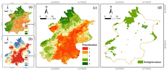
Figure 3.
(a) Protection values, (b) protection costs, (c) protection prioritization, and (d) ecological sources.
3.1.2. Ecological Corridors
We can see from Figure 4 that ecological corridors connect all ecological sources together and interweave into an ecological network in space. There are 30 ecological corridors with a total length of 228 km, 6 of which extend to the central urban area, and another 7 to Hebei province. The connection to the central urban area encourages greenway construction in the central area of Beijing, and the ecological corridors extending to Hebei province can play an active role in regional collaboration. Hebei province may take these ecological corridors as a reference when they delineate their ecological corridors.
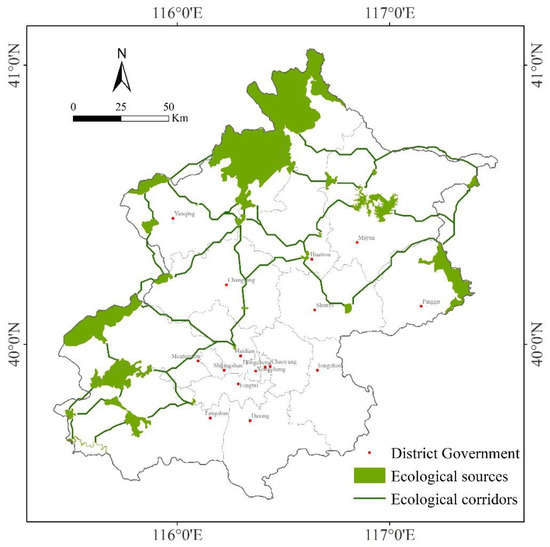
Figure 4.
Ecological corridors.
3.2. Cultural Nodes and Cultural Corridors
3.2.1. Cultural Nodes
Figure 5 illustrates the 423 cultural nodes. More than half are in the central urban area and the rest are scattered in the peripheral area (see Appendix A Table A3 for details). More cultural nodes are in the southwest and fewer in the northeast. Six historical and cultural towns/villages are all in peripheral areas with lower levels of urbanization, where many high-value historical buildings and ancient features are completely preserved. For example, Lingshui village has extremely rich cultural deposits that originated from the Ming Dynasty. In the north of Beijing, the Great Wall extends from the west to the northeast, along which there are many famous historical relics, such as Badaling, which is famous for its magnificent scenery, facilities, and profound history.
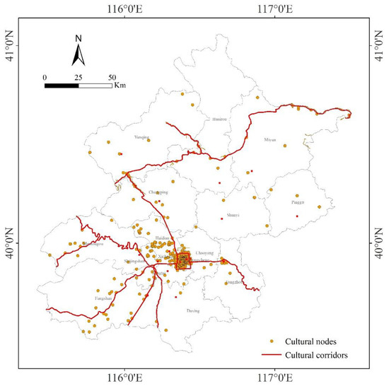
Figure 5.
Cultural nodes and cultural corridors.
After observations and trials, we found that a total of 83% of the cultural nodes are within 5 km of the cultural corridors, and these cultural nodes show significant spatial agglomeration characteristics. Therefore, 5 km is an appropriate width to conduct a buffer analysis of cultural nodes in order to delineate the culturally important areas.
3.2.2. Cultural Corridors
Figure 5 presents the cultural corridors in Beijing. The total length of these cultural corridors is 851 km. They are listed below:
- (1)
- The central district cultural corridor is bounded by the second ring road, which encloses 32.93% of Beijing’s cultural heritage. There are many cultural nodes in the area along the corridor, which has a large population. Visits to the heritage sites are more frequent than in other cultural corridor areas. At the same time, the impact from outside is greater and protection is more difficult.
- (2)
- The Great Wall cultural corridor extends along the ridgeline of the northern exurbs from west to northeast and covers famous heritage sites such as Badaling, Juyong Pass, Mutianyu, and Simatai. The development of the related cultural industry has promoted economic development and environmental protection in the area.
- (3)
- The Yongding-Qingshui River cultural corridor is mainly in the Mentougou District, extending from the south to the source of the Yongding River and its tributary, Qingshui River. The rich history in this corridor has led to numerous ancient villages and buildings being located there. The cultural corridor plays an important role in promoting the ancient capital, improving the ecological environment, and providing recreational space.
- (4)
- The Grand Canal cultural corridor extends from the city center to Hebei province, along which there are Huitong River, Tonghui River, Wanning bridge, and Dongbuya bridge. As the longest canal in the world, the Grand Canal has played an important role in the cultural and economic development and exchange between the north and the south of China. It was granted World Heritage site status in 2014.
- (5)
- The Beijing–Guangzhou line cultural corridor along the Beijing–Guangzhou railroad to Hebei province begins in the city center. It is an ancient recreational route. There are numerous cultural nodes in the vicinity of the corridor, such as Lugou bridge, Liangxiang tower, and Liuli River bridge.
- (6)
- The Beijing–Taiyuan line cultural corridor along the Beijing–Taiyuan railroad to Hebei province also originates in the city center. It is an ancient recreational route. Famous heritage sites along the cultural corridor include the Peking Man Site at Zhoukoudian, Tantuo temple, and Yao Guangxiao grave.
- (7)
- The Beijing–Baotou line cultural corridor is one of the imperial roads from the Ming Dynasty and Qing Dynasty. It starts from the city center and extends along the Beijing–Baotou railroad to the Badaling Great Wall and Ming Tombs. Famous heritage sites along the cultural corridor include the Beijing–Zhangjiakou Railway and Juyong Pass.
3.3. The Integrated Network
As illustrated in Figure 6, the integrated network visually reveals the relationships between ecological sources, cultural nodes, ecological corridors, and cultural corridors. Ecological sources are mainly distributed in exurbs, while cultural nodes are mainly located in central urban areas. However, the suburbs where ecological sources and cultural nodes coexist, such as Badaling Great Wall, Lingshui village, and Gubei town, are often the most popular tourist destinations, because they have multiple functions including leisure, experiencing traditional culture, and acquiring knowledge. Ecological corridors connecting all ecological sources interweave into a network in the exurbs, while cultural corridors radiate outward from the central urban area. At the same time, ecological corridors and cultural corridors share some intersection areas in the suburbs, which provide convenient positions for us to identify comprehensive regions.
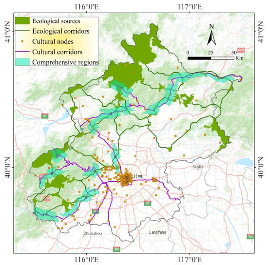
Figure 6.
Integrated network.
The comprehensive regions that have both ecological and cultural importance cover an area of 2916 km2, and are mainly distributed in forestland. We numbered these regions from 1 to 10, as illustrated in Figure 6. The Great Wall landscape and the Great Wall culture are the outstanding features of Numbers 1–4. Number 5, a famous tourist destination, is a region with a concentrated distribution of historical and cultural heritage, characterized by royal gardens from the Qing Dynasty. There is a tremendous legacy and beautiful scenery along the Yongding river in Numbers 6–7. Historical and cultural villages and ancient buildings are concentrated in Number 8. There are a lot of celebrated cultural heritage sites in Number 9, such as the Zhoukoudian Peking Man Site, the Jin mausoleum site, etc. Number 10 is located in the famous Juma River scenic spot. In these regions, rich ecological assets and cultural nodes blend well in space, and ecological corridors coexist with cultural corridors. The integration of mountains and cultural heritage is the prominent feature of Chinese mountain culture.
4. Discussion
The coordination between protection and development is a vital basis for regional planning. Extreme protection or development can lead to unsustainable regional development [3]. Identifying ecological sources based on their protection priority is an effective way to build a smart protection plan. Special guidelines for protection and development can be formulated according to the different characteristics of priority levels, which is also beneficial in terms of the efficient use of funds. Areas in the most urgent state should receive the earliest attention, and urban construction and other development activities should be strictly restricted in these areas. In the case study of Beijing, ecological sources and cultural nodes have shown distinct spatial distribution characteristics. Ecological sources are mainly located in a mountainous region with a large area of forestland and grassland. Cultural nodes are concentrated in the built-up areas, and they are greatly and easily affected by human development activities. However, human beings have been seeking ways to organically integrate with the natural environment. For example, many temples, relics, and traditional villages are integrated into the natural environment, which attracts a large number of tourists every year and provides people with places for leisure activities.
The protection and construction of ecological corridors is still problematic because both ecological benefits and economic development are important for urbanized areas [55]. In the ecosystem, the barrier effect of road networks on biological pathways cannot be ignored. Unlike ecological corridors, cultural corridors in this paper are delineated according to the distribution features of cultural heritage, rivers, and historical routes, which is a subjective process. Although the size and influence radius of cultural heritage have not been taken into account, cultural corridor buffers reveal priority protection areas and systematize the protection of cultural heritage. These culturally important areas deserve priority heritage protection and strict construction control in order for them to retain their local cultural atmosphere.
In the comprehensive regions, in which ecological assets and cultural nodes coexist harmoniously in space, heritage protection, ecological protection, and landscape renovation are the main tasks. These comprehensive regions hold great importance in landscape planning and cultural heritage protection for decision-makers and planners. It is extremely necessary to apply strict and effective measures to reduce the destruction of natural ecology and cultural heritage as a result of human development activities. Some regions have done better in this regard, such as comprehensive region Number 8, and the ecological environment and historical and cultural villages all have been well protected. However, in some other regions, like Number 10, ecological problems such as habitat degradation and water quality deterioration have emerged due to the over-exploitation of tourism activities. In a nutshell, what these regions need is more systematic policies and management strategies. Some engineering and cultural heritage protection measures should be taken into consideration, such as building underground passages, overpasses, cultural squares, relic parks, and cultural attractions. Construction activities should be strictly controlled, and landscape renovation should be carried out in existing construction areas.
The heritage datasets used in our study are the list from official heritage discourse, which is reliant on the knowledge claims of technical and aesthetic experts, and institutionalized in state cultural agencies and amenity societies [56]. Previous studies have shown that public participation can be an effective tool in landscape planning and management [31], but the expression of subaltern discourses of community participation in heritage management and conservation processes in our study is insufficient. In order to reveal the potential elements, participatory strategies and field investigation should be included in future research, and experts involved in research, management, and marketing of cultural heritage as well as local residents should be involved in this process.
Although there are distinctive differences between ecological corridors and cultural ecological corridors, some potential similarities remain. For example, some researchers focused on the topics of cultural heritage, tourism, ecosystem services in landscape corridor study at the same time [57,58,59]. However, so far, the study of cultural corridors remains relatively weak compared to that of ecological corridors [18,30], and there has not been a systematic methodology framework to combine ecological corridors and cultural corridors in the same context. Therefore, it is quite necessary to enrich the research of corridor framework by combining ecological corridor with cultural corridor. Ecological protection is not a local or personal matter, but one that needs the collaboration of experts from different disciplines and policymakers from different regions. The protection of cultural relics is not only a matter for cultural relic workers but also planners and decision-makers. The integrated analysis of ecological corridors and cultural corridors is significant for the implementation of an integrated protection strategy.
5. Conclusions
In this paper, we presented a method to delineate an integrated network that combines ecological corridors and cultural corridors. Along the integrated framework, we located many cultural heritage sites in areas that would be considered suitable for development using the traditional method, which only considers ecological elements when defining protection zones. We identified these areas as not being suitable for large-scale development, as it will lead to the destruction or even disappearance of local traditional features. Ecological and cultural corridors perform different functions, but they serve the same purpose of improving the quality of life. By considering them together, we can demonstrate the integral connection between them and cohesively protect areas of ecological and/or cultural significance. The integrated network can provide more reasonable suggestions for the optimization of the urban spatial structure. Different well-directed protection strategies can be adopted for three types of regions: ecologically important areas, culturally important areas, and ecologically and culturally important areas (comprehensive regions), which were obtained by buffer analysis and superposition analysis of ecological sources, ecological corridors, and cultural corridors.
This research method has no strict limit in terms of study scale, so it can be applied on larger (urban agglomeration) and smaller (county) scales as long as the data accuracy is acceptable, making it easy for decision-makers to implement at different levels. Our framework on the integrated network combines ecological corridors and cultural corridors in the same context, which makes the research on the two no longer isolated. Based on the result, we promote coordination of diversified aims, such as ecosystem services evaluation, biodiversity conservation, recreation and ecotourism, and heritage protection.
There is still room for improvement in our integrated network. Because the ecological corridors identified in our study are lines, we plan to explore practical quantitative methods to determine the width of corridors to guide the construction of an ecological network in the future. We also plan to include more views of local communities in the next phase of the study. The current setting of cultural corridor buffer distance is uniformly applied to all corridors. We realize that the influence radii of different cultural heritage sites can be quite different and plan to further explore more suitable methods for delineating variable cultural corridor buffer distances, which could be a combination of quantitative methods and qualitative methods to incorporate site specific information. In addition, we plan to collect local input of cultural sites to complement the heritage datasets. Finally, comprehensive regions are currently delineated from overlay analysis. We plan to enhance the method with stakeholder input and field investigation. We anticipate that accurate and practical delineation of the integrated network will support sustainable development goals.
Author Contributions
Conceptualization, X.W., Y.L., and X.D.; methodology, Y.L. and X.W.; formal analysis, X.W. and Y.L.; investigation, Y.L.; data curation, Y.L.; writing—original draft preparation, Y.L.; writing—review and editing, X.W.; visualization, Y.L.; supervision, X.D.; project administration, X.D. All authors have read and agreed to the published version of the manuscript.
Funding
This research was financially supported by the Fundamental Funds for Humanities and Social Sciences of Beijing Jiaotong University (2016jdzd02).
Institutional Review Board Statement
Not applicable.
Informed Consent Statement
Not applicable.
Data Availability Statement
Data can be provided upon request from the corresponding author.
Acknowledgments
The authors also acknowledge with gratitude Liam Foley and Yanyan Zhu for their advice in editing this paper.
Conflicts of Interest
The authors declare no conflict of interest.
Appendix A
Table A1.
Data sources in this study.
Table A1.
Data sources in this study.
| Data Name | Data Source |
|---|---|
| Digital Elevation Model (DEM) | Geospatial Data Cloud site, Computer Network Information Center, Chinese Academy of Sciences. (http://www.gscloud.cn) |
| Land cover data (2018) Roads (2018) Water bodies (2018) NDVI (2018) | International Scientific & Technical Data Mirror Site, Computer Network Information Center, Chinese Academy of Sciences. (http://www.resdc.cn) |
| Monthly average meteorological data (1980–2017) | China Meteorological Administration (http://cdc.nmic.cn/home.do) |
| Soil data | Cold and Arid Regions Sciences Data Center at Lanzhou (http://westdc.westgis.ac.cn) |
| Nature reserves (to 2017) | Beijing Municipal Environmental Protection Bureau (http://www.bjepb.gov.cn/bjhrb/index/index.html) |
| Cultural heritages (to 2019) | State Administration of Cultural Heritage (http://www.sach.gov.cn/) |
Table A2.
Nature reserves in Beijing (to 2017).
Table A2.
Nature reserves in Beijing (to 2017).
| Name | Main Protection Objects | Type |
|---|---|---|
| Song mountain | Wild animals, such as golden eagle, natural oil pine forest | Forest ecosystem |
| Baihua Mountain | Temperate secondary forest, such as brown eared pheasant, arethusa and Dahurian larch | Forest ecosystem |
| Labagoumen | Natural secondary forest | Forest ecosystem |
| Wild duck lake | Wetland and migratory bird | Wetland |
| Yunmeng Mountain | Secondary forest | Forest ecosystem |
| Yunfeng Mountain | Secondary Pinus Tabulaeformis | Forest ecosystem |
| Wuling mountain | Valuable and rare animals and plants, natural secondary forests and typical forest ecosystems. | Forest ecosystem |
| Sizuolou | Natural secondary forest and national protected plants (wild soybean, Amur corktree, tilia amurensis and Acanthopanax) | Forest ecosystem |
| Yudu mountain | Forest and wild animals and plants | Forest ecosystem |
| Lianhua mountain | Wild animals and plants | Forest ecosystem |
| Datan | Natural secondary forest and wild animals and plants | Forest ecosystem |
| Jinniu lake | Wetland | Wetland |
| Baihebao | Water conservation forest | Forest ecosystem |
| Taian mountain | Forest and wild animals and plants | Forest ecosystem |
| Shuitou | Forest and wild animals and plants | Forest ecosystem |
| Puwa | Forest ecosystem | Forest ecosystem |
| Hanshiqiao | Wetland and migratory bird | Wetland |
| Juma river | Aquatic wildlife, such as Giant salamander | Wetland |
| Huaisha and Huaijiu river | Aquatic wildlife, such as Giant salamander, needle-mackerel and mandarin duck | Wetland |
| Shihuadong | Karst caverns | Geological heritage |
| Chaoyang temple | Fossil wood | Geological heritage |
Table A3.
List of Cultural Heritage Sites in Beijing.
Table A3.
List of Cultural Heritage Sites in Beijing.
| Number | Name | Level |
|---|---|---|
| 1 | Ancient Cliff Dwelling Site | Beijing Municipal |
| 2 | Anti-Japanese War Sites of Yuzi Mountain | Beijing Municipal |
| 3 | Architectural Heritage of Beijing Normal University | Beijing Municipal |
| 4 | Architectural Heritage of Leshan Park | Beijing Municipal |
| 5 | Architecture Remains of Daci Yanfu Palace | Beijing Municipal |
| 6 | Architecture Remains of Nations’ Affairs Office | Beijing Municipal |
| 7 | Back Hall of Capital City Temple | Beijing Municipal |
| 8 | Bai Yihua Martyr Cemetery | Beijing Municipal |
| 9 | Baipu Temple | Beijing Municipal |
| 10 | Baoguo Temple and Gu Tinglin Temple | Beijing Municipal |
| 11 | Beiguan Dragon Temple | Beijing Municipal |
| 12 | Beihai, Tuancheng | Beijing Municipal |
| 13 | Beijia Park | Beijing Municipal |
| 14 | Beijing Babaoshan Revolutionary Cemetery | Beijing Municipal |
| 15 | Beijng Newspaper Museum | Beijing Municipal |
| 16 | Bi Xia Yuanjun Temple Site of Yahuan Mountain | Beijing Municipal |
| 17 | Cai Yuanpei’s Former Residence | Beijing Municipal |
| 18 | Changxindian “Twenty-seven” Revolutionary Sites | Beijing Municipal |
| 19 | Chaozhong Bridge | Beijing Municipal |
| 20 | Charity Temple | Beijing Municipal |
| 21 | Chen Duxiu’s Former Residence | Beijing Municipal |
| 22 | Cheng Yanqiu’s Former Residence | Beijing Municipal |
| 23 | Chengze Park | Beijing Municipal |
| 24 | Chinese Episcopal Church | Beijing Municipal |
| 25 | Church of St. Michael | Beijing Municipal |
| 26 | Clay City Site at Caizhuang | Beijing Municipal |
| 27 | Coloured Glaze Factory of the Ministry of Works of Qing Dynasty | Beijing Municipal |
| 28 | Confucius Temple | Beijing Municipal |
| 29 | Congress of the Republic of China | Beijing Municipal |
| 30 | Cross-Street Building of Sanguan Pavilion | Beijing Municipal |
| 31 | Cuandixia Ancient Residential village | Beijing Municipal |
| 32 | Da Park | Beijing Municipal |
| 33 | De Shoutang Pharmacy | Beijing Municipal |
| 34 | Diaoyutai and Yangyuan Temple | Beijing Municipal |
| 35 | Dinghui Temple | Beijing Municipal |
| 36 | Dongsi Mosque | Beijing Municipal |
| 37 | DongYue Temple | Beijing Municipal |
| 38 | Dongyue Temple, Shangzhuang | Beijing Municipal |
| 39 | Doudian Clay City | Beijing Municipal |
| 40 | Drama Stage of Anhui Guide Hall | Beijing Municipal |
| 41 | Drama Stage of Yangping Guide Hall | Beijing Municipal |
| 42 | Early Buildings of Beijing Hotel | Beijing Municipal |
| 43 | Eight Sites of Xishan Mountain | Beijing Municipal |
| 44 | Fanzi Stone Inscription | Beijing Municipal |
| 45 | Female Normal College of Former National Beiping University | Beijing Municipal |
| 46 | Fire God Temple of Huashi | Beijing Municipal |
| 47 | Fomer Site of Continential Bank (Beijing) | Beijing Municipal |
| 48 | Forked Road City | Beijing Municipal |
| 49 | Former Furen Univeisity | Beijing Municipal |
| 50 | Former Peking Union Medical College | Beijing Municipal |
| 51 | Former Sino-France University | Beijing Municipal |
| 52 | Former Site of American Embassy | Beijing Municipal |
| 53 | Former Site of Austrian Embassy | Beijing Municipal |
| 54 | Former Site of Bank of Communications | Beijing Municipal |
| 55 | Former Site of Bank of Gold | Beijing Municipal |
| 56 | Former Site of Banque Indosuez (Beijing) | Beijing Municipal |
| 57 | Former Site of Baoshang Bank | Beijing Municipal |
| 58 | Former Site of Bazaar | Beijing Municipal |
| 59 | Former Site of Beijing Origin | Beijing Municipal |
| 60 | Former Site of Belgian Embassy | Beijing Municipal |
| 61 | Former Site of Branch College of Beijing Normal University | Beijing Municipal |
| 62 | Former Site of British Embassy | Beijing Municipal |
| 63 | Former Site of Central Bank | Beijing Municipal |
| 64 | Former site of China Geology Investigation Institute | Beijing Municipal |
| 65 | Former Site of Chinese Bible Society | Beijing Municipal |
| 66 | Former Site of Citibank | Beijing Municipal |
| 67 | Former Site of Duan Qirui Government | Beijing Municipal |
| 68 | Former Site of Dutch Embassy | Beijing Municipal |
| 69 | Former Site of Exhibition Hall of Geology, Beijing University | Beijing Municipal |
| 70 | Former Site of French Embassy | Beijing Municipal |
| 71 | Former Site of French Post Office | Beijing Municipal |
| 72 | Former Site of General Post Office of the Qing Dynasty | Beijing Municipal |
| 73 | Former Site of Japanese Embassy | Beijing Municipal |
| 74 | Former Site of Jiaoshi Building and Baiyou Building of Fuyu Female School | Beijing Municipal |
| 75 | Former Site of Nanyuan Army Headquarters | Beijing Municipal |
| 76 | Former Site of North Telephone Subexchang of Beiping | Beijing Municipal |
| 77 | Former Site of Notre Dame French School | Beijing Municipal |
| 78 | Former Site of Salt Industry Bank | Beijing Municipal |
| 79 | Former Site of Tongzhou Army | Beijing Municipal |
| 80 | Former site of work study program in France in Chang Xindian | Beijing Municipal |
| 81 | Former Site of Zhengyangmen East Station of Beijing Fengtian Railway | Beijing Municipal |
| 82 | Former Teaching Building of Luhe Middle School | Beijing Municipal |
| 83 | Fuguo Street Quadrangle, Xicheng District | Beijing Municipal |
| 84 | Fusheng Temple | Beijing Municipal |
| 85 | Fuyou Temple | Beijing Municipal |
| 86 | Girderless Pavilion | Beijing Municipal |
| 87 | Glacial Striae | Beijing Municipal |
| 88 | Gold Hall of Huguo Temple | Beijing Municipal |
| 89 | Gonghua City | Beijing Municipal |
| 90 | Gonghua Palace | Beijing Municipal |
| 91 | Gongjian Ice Cellar | Beijing Municipal |
| 92 | Great Hall of Lingyan Temple | Beijing Municipal |
| 93 | Guangfu Temple | Beijing Municipal |
| 94 | Guanghua Temple | Beijing Municipal |
| 95 | Guangji Bridge | Beijing Municipal |
| 96 | Heilong Pool and Longwang Temple | Beijing Municipal |
| 97 | Heping Temple | Beijing Municipal |
| 98 | Hongluo Temple | Beijing Municipal |
| 99 | House at East Imperial Root South Street, Dongcheng District | Beijing Municipal |
| 100 | House at North Buzong Hutong, Dongcheng District | Beijing Municipal |
| 101 | House at Weijia Hutong, Dongcheng District | Beijing Municipal |
| 102 | Huguang Guide Hall | Beijing Municipal |
| 103 | Huixian Hall | Beijing Municipal |
| 104 | Hunan Guide Hall | Beijing Municipal |
| 105 | Huoshen Temple | Beijing Municipal |
| 106 | Imperial Ancestral Temple | Beijing Municipal |
| 107 | Imperial City Wall Site | Beijing Municipal |
| 108 | Imperial College Street | Beijing Municipal |
| 109 | Jade Emperor Tower | Beijing Municipal |
| 110 | Ji Xiaolan’s Former Residence | Beijing Municipal |
| 111 | Jiaolao Tai | Beijing Municipal |
| 112 | Jiemin Hall | Beijing Municipal |
| 113 | Jinghua Publishing House | Beijing Municipal |
| 114 | Jingming Park | Beijing Municipal |
| 115 | Jingyi Park (Xiangshan Moutain) | Beijing Municipal |
| 116 | Jintai Academy | Beijing Municipal |
| 117 | Jiufeng Seismic Station | Beijing Municipal |
| 118 | Juesheng Temple | Beijing Municipal |
| 119 | Kang Youwei’s Former Residence | Beijing Municipal |
| 120 | Lao She’s Former Residence | Beijing Municipal |
| 121 | Lejia Garden | Beijing Municipal |
| 122 | Li Dazhao’s Former Residence | Beijing Municipal |
| 123 | Liangxiang Tower | Beijing Municipal |
| 124 | Lingzhao Temple | Beijing Municipal |
| 125 | Liuyang Guide Hall | Beijing Municipal |
| 126 | Long’an Temple | Beijing Municipal |
| 127 | Longquan Temple of Bailong Pool | Beijing Municipal |
| 128 | Lotus Pool | Beijing Municipal |
| 129 | Lu Xun’s Former Residence | Beijing Municipal |
| 130 | Lumi Warehouse | Beijing Municipal |
| 131 | Lvzu Pavilion | Beijing Municipal |
| 132 | Main Building of Beijng Library | Beijing Municipal |
| 133 | Main Building of Italian Embassy Site | Beijing Municipal |
| 134 | Mansion of Beile Tao | Beijing Municipal |
| 135 | Mansion of Crown Prince of Ning County | Beijing Municipal |
| 136 | Mansion of Crown Prince of Shuncheng County | Beijing Municipal |
| 137 | Mansion of King Chun | Beijing Municipal |
| 138 | Mansion of King Fu | Beijing Municipal |
| 139 | Mansion of King Heng | Beijing Municipal |
| 140 | Mansion of King Li | Beijing Municipal |
| 141 | Mansion of King Qing | Beijing Municipal |
| 142 | Mansion of King Seng | Beijing Municipal |
| 143 | Mansion of King Zheng | Beijing Municipal |
| 144 | Mansion of Princess Hejing | Beijing Municipal |
| 145 | Mao Dun’s Former Residence | Beijing Municipal |
| 146 | Martyr Li Dazhao cemetery | Beijing Municipal |
| 147 | Mei Lanfang’s Former Residence | Beijing Municipal |
| 148 | Memorial of Sun Yat Sen’s Death | Beijing Municipal |
| 149 | Monument to the Luanzhou Uprising | Beijing Municipal |
| 150 | Monument to the Martyrs who Died in the Anti-Japanese War in Wanping County | Beijing Municipal |
| 151 | Nangangwa Bridge | Beijing Municipal |
| 152 | Niangniang Temple of North Peak | Beijing Municipal |
| 153 | Nianhua Temple | Beijing Municipal |
| 154 | Ninghe Temple | Beijing Municipal |
| 155 | Niujie Street Mosque | Beijing Municipal |
| 156 | No.36 Fuxue Hutong, Dongcheng District | Beijing Municipal |
| 157 | No.63–65 Quadrangle, Dongsiliutiao, Dongcheng District | Beijing Municipal |
| 158 | North Guide Hall of Tingzhou, Fujian | Beijing Municipal |
| 159 | North New Warehouse | Beijing Municipal |
| 160 | Old Messuage | Beijing Municipal |
| 161 | Old Style Shops | Beijing Municipal |
| 162 | Public Elder Longevity Tower | Beijing Municipal |
| 163 | Publishing Factory Site of Ministry of Finance of the Republic of China | Beijing Municipal |
| 164 | Puzhao Temple | Beijing Municipal |
| 165 | Qi Baishi’s Former Residence | Beijing Municipal |
| 166 | Qinghe Hancheng Site | Beijing Municipal |
| 167 | Qingyin Pavilion of Yunhui Building | Beijing Municipal |
| 168 | Randeng Tower | Beijing Municipal |
| 169 | Remains of Mansion of Zhaohui | Beijing Municipal |
| 170 | Remains of the School Department in Qing Dynasty | Beijing Municipal |
| 171 | Residence Group of Union Hospital | Beijing Municipal |
| 172 | Riverside City and Enemy Platform | Beijing Municipal |
| 173 | Rong Tomb Site at Yuhuangmiao Mountain | Beijing Municipal |
| 174 | Ruins of Shang, Zhou Dynasty at Liu Lihe | Beijing Municipal |
| 175 | Sansheng Temple | Beijing Municipal |
| 176 | Shangzhai Cultural Site | Beijing Municipal |
| 177 | Shaoxing Guide Hall | Beijing Municipal |
| 178 | Sheng Pingshu Drama Stage | Beijing Municipal |
| 179 | Shifang Buddists Tower | Beijing Municipal |
| 180 | Shijia Hutong, Dongcheng District | Beijing Municipal |
| 181 | Shuanglin Temple | Beijing Municipal |
| 182 | Shuiguan Great Wall | Beijing Municipal |
| 183 | Shuntian State-run School | Beijing Municipal |
| 184 | Shuqu Square Stele of Zhengyang Bridge | Beijing Municipal |
| 185 | Sibei Temple, Tao ranting | Beijing Municipal |
| 186 | No.11 Quadrangle, Neiwubu Street, Dongcheng District | Beijing Municipal |
| 187 | No.11 Quadrangle, Xisibei 3, Xicheng District | Beijing Municipal |
| 188 | No.129 Quadrangle, Lishi Hutong, Dongcheng District | Beijing Municipal |
| 189 | No.13,15 Quadrangle, Fangjia Hutong, Dongcheng District | Beijing Municipal |
| 190 | No.15 Quadrangle, Qian Gongyong Hutong, Xicheng District | Beijing Municipal |
| 191 | No.19 Quadrangle, Xisibei 3, Xicheng District | Beijing Municipal |
| 192 | No.2 Quadrangle, Guoxiang Hutong, Dongcheng District | Beijing Municipal |
| 193 | No.20 Quadrangle, Xinkai Road, Chongwen District | Beijing Municipal |
| 194 | No.23 Quadrangle, Xisibei Avenue 6, Xicheng District | Beijing Municipal |
| 195 | No.7,9 Quadrangle, Back Yuan’en Temple Street, Dongcheng District | Beijing Municipal |
| 196 | No.15 Quadrangle and its Tile Carving, Dongmianhua Hutong, Dongcheng District | Beijing Municipal |
| 197 | No.25 Quadrangle, Art Museum East Street, Dongcheng District | Beijing Municipal |
| 198 | No.153 Quadrangle, Di’anmenxi Avenue, Xicheng District | Beijing Municipal |
| 199 | No.93 Quadrangle, Fuchengmennei Street, Xicheng District | Beijing Municipal |
| 200 | No.255 Quadrangle, Gulou East Avenue, Dongcheng District | Beijing Municipal |
| 201 | No.13 Quadrangle, Heizhima Hutong, Dongcheng District | Beijing Municipal |
| 202 | No.5 Quadrangle, Maoer Hutong, Dongcheng District | Beijing Municipal |
| 203 | No.7,9 Quadrangle, Qiangulouyuan Hutong, Dongcheng District | Beijing Municipal |
| 204 | No.7,9 Quadrangle, Qianyongkang Hutong, Dongcheng District | Beijing Municipal |
| 205 | No.15 Quadrangle, Shajing Hutong, Dongcheng District | Beijing Municipal |
| 206 | Quadrangle, Xijiaominxiang Street 87, Beixinhua Street 112, Xicheng District | Beijing Municipal |
| 207 | No.25–37 Quadrangle, Xitangzi Hutong, Dongcheng District | Beijing Municipal |
| 208 | Site of Chinese Communist Delegation of the Ministry of Military Transfer in 1946 | Beijing Municipal |
| 209 | Site of European and American students’ Association | Beijing Municipal |
| 210 | Site of Hebei-Rehe-Chahaer Advance Army Commander’s Headquarter of Eight Route Army | Beijing Municipal |
| 211 | Site of Taiye Pool at the Mid-capital of the Kin Dynasty | Beijing Municipal |
| 212 | Site of the Farmer and Worker Bank of China | Beijing Municipal |
| 213 | Site of Tuanhe Palace | Beijing Municipal |
| 214 | Site of Xizhi Men Station of Pingsui | Beijing Municipal |
| 215 | Sites of Bai Fuquan | Beijing Municipal |
| 216 | Sites of Da Baotai Tombs of Western Han Dynasty | Beijing Municipal |
| 217 | Songzhu Temple and Zhizhu Temple | Beijing Municipal |
| 218 | South Mansion of King Chun | Beijing Municipal |
| 219 | South New Warehouse | Beijing Municipal |
| 220 | Southeastern Corner Tower of the City | Beijing Municipal |
| 221 | Stage and Guandi Temple at Huapen Village | Beijing Municipal |
| 222 | Stone Buddha in Baishui Temple | Beijing Municipal |
| 223 | Stone Sculptures of Yi Sanga | Beijing Municipal |
| 224 | Temple of Empress of Fengtai | Beijing Municipal |
| 225 | Temples and Yunshui Cave at Shangfang Moutain | Beijing Municipal |
| 226 | The Bell Tower | Beijing Municipal |
| 227 | The Chairman Mao Memorial Hall | Beijing Municipal |
| 228 | The Drum Tower | Beijing Municipal |
| 229 | The Former Chartered Bank | Beijing Municipal |
| 230 | The Front of Former Site of Qian Xiangyi | Beijing Municipal |
| 231 | The Front of Former Site of Rui Fuxiang | Beijing Municipal |
| 232 | The Front of Quanjude Roast Duck | Beijing Municipal |
| 233 | The Great Hall of Pudu Temple | Beijing Municipal |
| 234 | The Great Hall of Shuntian Mansion | Beijing Municipal |
| 235 | The Interior Office of Inspecting the Imperial Government in Qing Dynasty | Beijing Municipal |
| 236 | The Land Altar (Zhongshan Park) | Beijing Municipal |
| 237 | The Remains of Beijing City Wall in Ming Dynasty | Beijing Municipal |
| 238 | The statue of Wei Taihe | Beijing Municipal |
| 239 | The Tenth Hotel at Grain Shop Street | Beijing Municipal |
| 240 | Three Eighteen Martyr Monument | Beijing Municipal |
| 241 | Tianli Coal Factory Site | Beijing Municipal |
| 242 | Tiewa Temple | Beijing Municipal |
| 243 | Tomb of Crown Prince of Fu County | Beijing Municipal |
| 244 | Tomb of Laoshan of Han Dynasty | Beijing Municipal |
| 245 | Tomb of Li Zhuowu | Beijing Municipal |
| 246 | Tomb of Liang Qichao | Beijing Municipal |
| 247 | Tomb of Sunyue | Beijing Municipal |
| 248 | Tomb of Tianyi | Beijing Municipal |
| 249 | Tomb, Stele and Status of Zhan Tianyou | Beijing Municipal |
| 250 | Tombs of Lu Huixiang’s Family | Beijing Municipal |
| 251 | Tombs of Soldiers and Men Killed in the Battle of Gubeikou | Beijing Municipal |
| 252 | Tongyun Bridge and Remains of Zhang Jiawan City Wall | Beijing Municipal |
| 253 | Tongzhou Mosque | Beijing Municipal |
| 254 | Tower of Zen Master Wuai | Beijing Municipal |
| 255 | Tuancheng Fortress | Beijing Municipal |
| 256 | Tucheng | Beijing Municipal |
| 257 | Wanning Bridge | Beijing Municipal |
| 258 | Waterworks of Qing Dynasty | Beijing Municipal |
| 259 | Weiming Lake District, Former Yanjing University | Beijing Municipal |
| 260 | Wofo Temple | Beijing Municipal |
| 261 | Wuta Tower | Beijing Municipal |
| 262 | Xianliang Temple | Beijing Municipal |
| 263 | Xianying Temple | Beijing Municipal |
| 264 | Xihuang Temple | Beijing Municipal |
| 265 | Xishiku Church | Beijing Municipal |
| 266 | Xiuyun Temple | Beijing Municipal |
| 267 | Xuanren Temple | Beijing Municipal |
| 268 | Xuechi Ice Cellar | Beijing Municipal |
| 269 | Xuhua Pavilion and Song Hall | Beijing Municipal |
| 270 | Yandun | Beijing Municipal |
| 271 | Yang Jiaoshan Temple | Beijing Municipal |
| 272 | Yaowang Temple of Fengtai | Beijing Municipal |
| 273 | Yinshan Tower | Beijing Municipal |
| 274 | Yiyuan Park | Beijing Municipal |
| 275 | Yongning Catholic Church | Beijing Municipal |
| 276 | Yuansheng Palace | Beijing Municipal |
| 277 | Yun Tai | Beijing Municipal |
| 278 | Yuqian Temple | Beijing Municipal |
| 279 | Zhao Tower | Beijing Municipal |
| 280 | Zhaoxian Temple | Beijing Municipal |
| 281 | Zhengyang Gate and Arrow tower | Beijing Municipal |
| 282 | Zhengyi Temple | Beijing Municipal |
| 283 | Zhongshan Guide Hall | Beijing Municipal |
| 284 | Zhou Jixiang Tower | Beijing Municipal |
| 285 | Zhu Yizhun’s Former Residence | Beijing Municipal |
| 286 | Cuandixia Village, Zhaitang Town | National |
| 287 | Gubeikou Town | National |
| 288 | Jiaozhuanghu Village, Longwantun Town | National |
| 289 | Lingshui Village, Zhaitang Town | National |
| 290 | Liuliqu Village, Longquan Town | National |
| 291 | Shuiyu Village, Nanjiao Town | National |
| 292 | Ancient Building Group in Cuandixia Village | National |
| 293 | Ancient Cliff Dwelling in Yanqing | National |
| 294 | Ancient Weather Station | National |
| 295 | Anhui Guide Hall | National |
| 296 | Badaling Great Wall | National |
| 297 | Baiyun Temple | National |
| 298 | Baoguo Temple | National |
| 299 | Beihai and Tuancheng | National |
| 300 | Beijing Bell Tower, Drum Tower | National |
| 301 | Beijing City Walls of the Ming Dynasty | National |
| 302 | Beijing Huguang Guide Hall | National |
| 303 | Biyun Temple | National |
| 304 | Bolin Temple | National |
| 305 | Bridge of Liuli River | National |
| 306 | Buddists Hall, Stone Inscription and Tower of Kongshui Cave | National |
| 307 | Changchun Temple | National |
| 308 | Cheng’en Temple | National |
| 309 | Chinese Episcopal Church | National |
| 310 | Chongli Residence | National |
| 311 | Church of Xi Shiku | National |
| 312 | Cishou Temple Tower | National |
| 313 | Commerce Building in Dashila Area | National |
| 314 | Confucius Temple | National |
| 315 | Da Gaoxuan Hall | National |
| 316 | Dahui Temple | National |
| 317 | Dajue Temple | National |
| 318 | Desheng Gate Archery Tower | National |
| 319 | Dongyue Temple, Beijing | National |
| 320 | Duobao Buddist Tower of Liangxiang | National |
| 321 | Early Architectures inTshinghua Univeisity | National |
| 322 | East Hall | National |
| 323 | Embassy Architecture Group of Dongjiaominxiang | National |
| 324 | Fahai Temple | National |
| 325 | Fayuan Temple | National |
| 326 | Former Site of Agricultural Experimental Farm of Qing Dynasty | National |
| 327 | Former Site of Beijing Branch of China Bible Church | National |
| 328 | Former Site of Beijing Female Normal College | National |
| 329 | Former Site of Beijing Parliament | National |
| 330 | Former Site of Beiping Library | National |
| 331 | Former Site of Branch College of Beijing Normal University | National |
| 332 | Former Site of Exhibition Hall of Geology, Beijing University | National |
| 333 | Former Site of Main Campus of Furen University | National |
| 334 | Former Site of National Mongolian Tibetan School | National |
| 335 | Former Site of Peking Union Medical College | National |
| 336 | Former Site of Radio 491 | National |
| 337 | Former Sites of Shengxin Middle School and Youzhen Female Middle School | National |
| 338 | Former Sites of the Army and Navy Departments of the Qing Dynasty | National |
| 339 | Gate of Heavenly Peace | National |
| 340 | Guangji Temple | National |
| 341 | Guanyue Temple | National |
| 342 | Guide Hall of Sun Yat-sen | National |
| 343 | Guo Moruo’s Former Residence | National |
| 344 | Imperial Ancestral Temple | National |
| 345 | Imperial Archives | National |
| 346 | Imperial College | National |
| 347 | Jianruiying Martial Arts Hall | National |
| 348 | Jiaozhuanghu Tunnel Battle Site | National |
| 349 | Jietai Temple | National |
| 350 | Jingming Park | National |
| 351 | Juesheng Temple | National |
| 352 | Ke Park | National |
| 353 | Li Dazhao’s Former Residence | National |
| 354 | Lingyue Temple | National |
| 355 | Lu Xun’s Former Residence in Beijing | National |
| 356 | Lugou Bridge | National |
| 357 | Mansion of Crown Prince of Keqin County | National |
| 358 | Mansion of King Chun | National |
| 359 | Mansion of King Fu | National |
| 360 | Mei Lanfang’s Former Residence | National |
| 361 | Memorial Park of Luanzhou Uprising of Xinhai Year | National |
| 362 | Modern Bank Building Group in Xijiaominxiang | National |
| 363 | Modern School Buildings Group in Tongzhou | National |
| 364 | Moke Temple | National |
| 365 | Mout Jing | National |
| 366 | Nankou-Badaling Section of Jing-Zhang Raiway | National |
| 367 | Niujie Street Mosque | National |
| 368 | Peking Man Site at Zhoukoudian | National |
| 369 | Prince Gong’s Mansion and Park | National |
| 370 | Publishing House Site of Ministry of Finance of the Republic of China | National |
| 371 | Pudu Temple | National |
| 372 | Qingjinghuacheng Tower | National |
| 373 | Red Building in Peking University | National |
| 374 | Remains of Great-Capital City Wall of Yuan Dynasty | National |
| 375 | Shangzhai Site | National |
| 376 | Shifang Pujue Temple | National |
| 377 | Shuangqing Villa | National |
| 378 | Shuiguan Site of the Mid-Capital of the Kin Dynasty | National |
| 379 | Simatai Section of Great Wall | National |
| 380 | Site of Jinling | National |
| 381 | Site of Liuli River | National |
| 382 | Site of Old Summer Palace | National |
| 383 | Site of Shizi Temple | National |
| 384 | Song Qingling Children’s Science and Technology Museum | National |
| 385 | Song Qingling’s Former Residence in Beijing | National |
| 386 | South Hall | National |
| 387 | Southeastern Corner Tower of the Beijing City | National |
| 388 | Staiton Building of Beijng Railway Station | National |
| 389 | Summer Palace | National |
| 390 | Tantuo Temple | National |
| 391 | Temple of Heaven | National |
| 392 | Temple of the Moon | National |
| 393 | Temple of the Past-Ages Emperors | National |
| 394 | Temple of Wen Tianxiang | National |
| 395 | The Altar to the Sun | National |
| 396 | The Forbidden City | National |
| 397 | The Lama Temple | National |
| 398 | The Land Altar | National |
| 399 | The Ming Tombs | National |
| 400 | The Site of Atomic Energy | National |
| 401 | The Site of the Two-Seven Strike in Changxindian | National |
| 402 | The Monument to the People’s Heroes | National |
| 403 | Tianning Temple Tower | National |
| 404 | Tomb and Temple of Yuan Chonghuan | National |
| 405 | Tomb of Jingtai | National |
| 406 | Tomb of King Chun | National |
| 407 | Tombs of Matteo Ricci and Foreign Missionaries of Ming, Qing Dynasties | National |
| 408 | Wanshou Temple | National |
| 409 | Wansong Elder Tower | National |
| 410 | White Tower of Miaoying Temple | National |
| 411 | Wuta Temple Tower | National |
| 412 | Xiannong Altar | National |
| 413 | Yanyuan Buildings of Weiming Lake | National |
| 414 | Yao Guangxiao Tomb Tower | National |
| 415 | Yasili Hall | National |
| 416 | Yinshan Forest of Pagodas | National |
| 417 | Yun Terrace in Juyong Pass | National |
| 418 | Yunju Temple Tower and Stone Scripture of Fangshan | National |
| 419 | Zhengang Tower | National |
| 420 | Zhengyang Gate | National |
| 421 | Zhihua Temple | National |
| 422 | Zhizhu Temple | National |
| 423 | Zhong Nan Hai | National |
References
- Fang, C.; Yu, D. Urban agglomeration: An evolving concept of an emerging phenomenon. Landsc. Urban Plan. 2017, 162, 126–136. [Google Scholar] [CrossRef]
- Nations, U. Growing at a Slower Pace, World Population is Expected to Reach 9.7 Billion in 2050 and Could Peak at Nearly 11 Billion around 2100. Available online: https://www.un.org/development/desa/en/news/population/world-population-prospects-2019.html (accessed on 23 March 2020).
- Li, Y.; Li, Y.; Zhou, Y.; Shi, Y.; Zhu, X. Investigation of a coupling model of coordination between urbanization and the environment. J. Environ. Manag. 2012, 98, 127–133. [Google Scholar] [CrossRef] [PubMed]
- Gunawardhana, L.N.; Kazama, S.; Kawagoe, S. Impact of Urbanization and Climate Change on Aquifer Thermal Regimes. Water Resour. Manag. 2011, 25, 3247–3276. [Google Scholar] [CrossRef]
- Breuste, J.; Qureshi, S.; Li, J. Applied urban ecology for sustainable urban environment. Urban Ecosyst. 2013, 16, 675–680. [Google Scholar] [CrossRef]
- Taylor, L.; Hochuli, D.F. Creating better cities: How biodiversity and ecosystem functioning enhance urban residents’ wellbeing. Urban Ecosyst. 2015, 18, 747–762. [Google Scholar] [CrossRef]
- Breuste, J.; Qureshi, S. Urban sustainability, urban ecology and the Society for Urban Ecology (SURE). Urban Ecosyst. 2011, 14, 313–317. [Google Scholar] [CrossRef]
- Wu, J. Urban sustainability: An inevitable goal of landscape research. Landsc. Ecol. 2010, 25, 1–4. [Google Scholar] [CrossRef]
- Wu, J. Landscape sustainability science: Ecosystem services and human well-being in changing landscapes. Landsc. Ecol. 2013, 28, 999–1023. [Google Scholar] [CrossRef]
- Assessment, M.E. Ecosystems and Human Well-Being: A Framework for Assessment; Island Press: Washington, DC, USA, 2003. [Google Scholar]
- Daily, G.C. Nature’s Services: Societal Dependence on Natural Ecosystems; Island Press: Washington, DC, USA, 1997. [Google Scholar]
- Costanza, R.; d’Arge, R.; de Groot, R.; Farber, S.; Grasso, M.; Hannon, B.; Limburg, K.; Naeem, S.; O’Neill, R.V.; Paruelo, J.; et al. The value of the world’s ecosystem services and natural capital. Nature 1997, 387, 253–260. [Google Scholar] [CrossRef]
- Nahlik, A.M.; Kentula, M.E.; Fennessy, M.S.; Landers, D.H. Where is the consensus? A proposed foundation for moving ecosystem service concepts into practice. Ecol. Econ. 2012, 77, 27–35. [Google Scholar] [CrossRef]
- Kubiszewski, I.; Costanza, R.; Anderson, S.; Sutton, P. The future value of ecosystem services: Global scenarios and national implications. Ecosyst. Serv. 2017, 26, 289–301. [Google Scholar] [CrossRef]
- Braat, L.C.; de Groot, R. The ecosystem services agenda:bridging the worlds of natural science and economics, conservation and development, and public and private policy. Ecosyst. Serv. 2012, 1, 4–15. [Google Scholar] [CrossRef]
- Costanza, R.; de Groot, R.; Sutton, P.; van der Ploeg, S.; Anderson, S.J.; Kubiszewski, I.; Farber, S.; Turner, R.K. Changes in the global value of ecosystem services. Glob. Environ. Chang. Part A Hum. Policy Dimens. 2014, 26, 152–158. [Google Scholar] [CrossRef]
- Wolff, S.; Schulp, C.J.E.; Verburg, P.H. Mapping ecosystem services demand: A review of current research and future perspectives. Ecol. Indic. 2015, 55, 159–171. [Google Scholar] [CrossRef]
- Zhang, L.; Peng, J.; Liu, Y.; Wu, J. Coupling ecosystem services supply and human ecological demand to identify landscape ecological security pattern: A case study in Beijing–Tianjin–Hebei region, China. Urban Ecosyst. 2017, 20, 701–714. [Google Scholar] [CrossRef]
- Xie, H.; Yao, G.; Liu, G. Spatial evaluation of the ecological importance based on GIS for environmental management: A case study in Xingguo county of China. Ecol. Indic. 2015, 51, 3–12. [Google Scholar] [CrossRef]
- Campolo, D.; Bombino, G.; Meduri, T. Cultural Landscape and Cultural Routes: Infrastructure Role and Indigenous Knowledge for a Sustainable Development of Inland Areas. Procedia-Soc. Behav. Sci. 2016, 223, 576–582. [Google Scholar] [CrossRef]
- Liang, J.; He, X.; Zeng, G.; Zhong, M.; Gao, X.; Li, X.; Li, X.; Wu, H.; Feng, C.; Xing, W.; et al. Integrating priority areas and ecological corridors into national network for conservation planning in China. Sci. Total Environ. 2018, 626, 22–29. [Google Scholar] [CrossRef]
- Hoppert, M.; Bahn, B.; Bergmeier, E.; Deutsch, M.; Epperlein, K.; Hallmann, C.; Mller, A.; Platz, T.V.; Reeh, T.; Stck, H.; et al. The Saale-Unstrut cultural landscape corridor. Environ. Earth Sci. 2018, 77, 58. [Google Scholar] [CrossRef]
- Oikonomopoulou, E.a.; Delegou, E.T.A.; Sayas, J.B.; Moropoulou, A.A. An innovative approach to the protection of cultural heritage: The case of cultural routes in Chios Island, Greece. J. Archaeol. Sci. Rep. 2017, 14, 742–757. [Google Scholar] [CrossRef]
- Pierik, M.; Dell’Acqua, M.; Confalonieri, R.; Bocchi, S.; Gomarasca, S. Designing ecological corridors in a fragmented landscape: A fuzzy approach to circuit connectivity analysis. Ecol. Indic. 2016, 67, 807–820. [Google Scholar] [CrossRef]
- Ye, H.; Yang, Z.; Xu, X. Ecological Corridors Analysis Based on MSPA and MCR Model—A Case Study of the Tomur World Natural Heritage Region. Sustainability 2020, 12, 959. [Google Scholar] [CrossRef]
- Lewis, P.H. Landscape Resources. In The Wisconsin Blue Book; Rupert, T.H., Ed.; Wisconsin Legislative Reference Bureau: Madison, WI, USA, 1964; pp. 130–142. [Google Scholar]
- Lee, J.A.; Chon, J.; Ahn, C. Planning Landscape Corridors in Ecological Infrastructure Using Least-Cost Path Methods Based on the Value of Ecosystem Services. Sustainability 2014, 6, 7564–7585. [Google Scholar] [CrossRef]
- Mossman, H.L.; Panter, C.J.; Dolman, P.M. Modelling biodiversity distribution in agricultural landscapes to support ecological network planning. Landsc. Urban Plan. 2015, 141, 59–67. [Google Scholar] [CrossRef]
- Shishmanova, M.V. Cultural Tourism in Cultural Corridors, Itineraries, Areas and Cores Networked. Procedia-Soc. Behav. Sci. 2015, 188, 246–254. [Google Scholar] [CrossRef]
- Xu, H.; Plieninger, T.; Primdahl, J. A Systematic Comparison of Cultural and Ecological Landscape Corridors in Europe. Land 2019, 8, 41. [Google Scholar] [CrossRef]
- Eiter, S.; Vik, M.L. Public participation in landscape planning: Effective methods for implementing the European Landscape Convention in Norway. Land Use Policy 2015, 44, 44–53. [Google Scholar] [CrossRef]
- Ahn, S.; Kim, S. Assessment of watershed health, vulnerability and resilience for determining protection and restoration Priorities. Environ. Model. Softw. 2019, 122, 103926. [Google Scholar] [CrossRef]
- Opdam, P.; Steingröver, E.; Rooij, S.V. Ecological networks: A spatial concept for multi-actor planning of sustainable landscapes. Landsc. Urban Plan. 2006, 75, 322–332. [Google Scholar] [CrossRef]
- Naidoo, R.; Balmford, A.; Ferraro, P.J.; Polasky, S.; Ricketts, T.H.; Rouget, M. Integrating economic costs into conservation planning. Trends Ecol. Evol. 2006, 21, 681–687. [Google Scholar] [CrossRef]
- Prahl, B.F.; Boettle, M.; Costa, L.; Kropp, J.P.; Rybski, D. Damage and protection cost curves for coastal floods within the 600 largest European cities. Sci. Data 2018, 5, 1–18. [Google Scholar] [CrossRef] [PubMed]
- Zhu, M.; Xi, X.; Hoctor, T.S.; Volk, M. Integrating conservation costs into sea level rise adaptive conservation prioritization. Glob. Ecol. Conserv. 2015, 4, 48–62. [Google Scholar] [CrossRef]
- Manhães, A.P.; Loyola, R.; Mazzochini, G.G.; Ganade, G.; Oliveira-Filho, A.T.; Carvalho, A.R. Low-cost strategies for protecting ecosystem services and biodiversity. Biol. Conserv. 2018, 217, 187–194. [Google Scholar] [CrossRef]
- Alexakis, D.D.; Hadjimitsis, D.G.; Agapiou, A. Integrated use of remote sensing, GIS and precipitation data for the assessment of soil erosion rate in the catchment area of “Yialias” in Cyprus. Atmos. Res. 2013, 131, 108–124. [Google Scholar] [CrossRef]
- Renard, K.G.; Foster, F.G.; Weesies, G.A.; McCool, K.K.; Yoder, D.C. Predicting Soil Loss Erosion by Water: A Guide to Conservation Planning with the Revised Universal Soil Loss Equation (RUSLE); US Government Printing Office: Washington, DC, USA, 1997.
- Yang, Z.; Wu, J. Conservation cost of China’s nature reserves and its regional distribution. J. Nat. Resour. 2019, 34, 839–852. [Google Scholar]
- Armsworth, P.R.; Cantú-Salazar, L.; Parnell, M.; Davies, Z.G.; Stoneman, R. Management costs for small protected areas and economies of scale in habitat conservation. Biol. Conserv. 2011, 144, 423–429. [Google Scholar] [CrossRef]
- Tao, G.; Ou, X.; Guo, Y.; Xu, Q.; Yu, Q.; Zhang, Z.; Wang, C. Priority area identification for vegetation in northwest Yunnan, based on protection value and protection cost. Acta Ecol. Sin. 2016, 36, 5777–5789. [Google Scholar]
- Huck, M.; Jędrzejewski, W.; Borowik, T.; Jędrzejewska, B.; Nowak, S.; Mysłajek, R.W. Analyses of least cost paths for determining effects of habitat types on landscape permeability: Wolves in Poland. Acta Theriol. 2011, 56, 91–101. [Google Scholar] [CrossRef]
- Knaapen, J.P.; Scheffer, M.; Harms, B. Estimating habitat isolation in landscape planning. Landsc. Urban Plan. 1992, 23, 1–16. [Google Scholar] [CrossRef]
- Gurrutxaga, M.; Rubio, L.; Saura, S. Key connectors in protected forest area networks and the impact of highways: A transnational case study from the Cantabrian Range to the Western Alps (SW Europe). Landsc. Urban Plan. 2011, 101, 310–320. [Google Scholar] [CrossRef]
- Hepcan, C.C.; Ozkan, M.B. Establishing ecological networks for habitat conservation in the case of Çeşme-Urla Peninsula, Turkey. Environ. Monit. Assess. 2011, 174, 157–170. [Google Scholar] [CrossRef] [PubMed]
- Yu, K.; Wang, S.; Li, D. Regional Ecological Security Patterns: The Beijing Case. Beijing: China; Architecture & Building Press: Beijing, China, 2012. [Google Scholar]
- UNESCO. What is Intangible Cultural Heritage? Available online: https://ich.unesco.org/en/what-is-intangible-heritage-00003/ (accessed on 15 November 2020).
- Bozic, S.; Tomic, N. Developing the Cultural Route Evaluation Model (CREM) and its application on the Trail of Roman Emperors. Tour. Manag. Perspect. 2016, 17, 26–35. [Google Scholar] [CrossRef]
- Xu, H.; Zhao, G.; Fagerholm, N.; Primdahl, J.; Plieninger, T. Participatory mapping of cultural ecosystem services for landscape corridor planning: A case study of the Silk Roads corridor in Zhangye, China. J. Environ. Manag. 2020, 264, 110458. [Google Scholar] [CrossRef] [PubMed]
- Zhu, Q.; Yu, K.; Li, D. The width of ecological corridor in landscape planning. Acta Ecol. Sin. 2005, 25, 2406–2412. [Google Scholar]
- Wu, J.; Li, X.; Long, N.; Xiao, J. Ecological Corridor Network Planning for Dense City Areas: A Case Study of Guangzhou Metropolitan Area. Mod. Urban Res. 2017, 2017, 61–67. [Google Scholar] [CrossRef]
- Fabos, J.G. Introduction and overview: The greenway movement, uses and potentials of greenways. Landsc. Urban Plan. 1995, 33, 1–13. [Google Scholar] [CrossRef]
- Li, L.; Shao, M.; Wang, S.; Li, Z. Preservation of earthen heritage sites on the Silk Road, northwest China from the impact of the environment. Environ. Earth Sci. 2011, 64, 1625–1639. [Google Scholar] [CrossRef]
- Peng, J.; Zhao, H.; Liu, Y. Urban ecological corridors construction: A review. Acta Ecol. Sin. 2017, 37, 23–30. [Google Scholar] [CrossRef]
- Smith, L. Uses of Heritage; Routeledge: London, UK; New York, NY, USA, 2006. [Google Scholar]
- Von Haaren, C.; Reich, M. The German way to greenways and habitat networks. Landsc. Urban Plan. 2006, 76, 7–22. [Google Scholar] [CrossRef]
- Manton, R.; Clifford, E. Identification and classification of factors affecting route selection of cycling routes in Ireland. Cycl. Res. Int. 2012, 3, 136–153. [Google Scholar]
- Ottomano Palmisano, G.; Loisi, R.V.; Ruggiero, G.; Rocchi, L.; Boggia, A.; Roma, R.; Dal Sasso, P. Using Analytic Network Process and Dominance-based Rough Set Approach for sustainable requalification of traditional farm buildings in Southern Italy. Land Use Policy 2016, 59, 95–110. [Google Scholar] [CrossRef]


Publisher’s Note: MDPI stays neutral with regard to jurisdictional claims in published maps and institutional affiliations. |
© 2021 by the authors. Licensee MDPI, Basel, Switzerland. This article is an open access article distributed under the terms and conditions of the Creative Commons Attribution (CC BY) license (http://creativecommons.org/licenses/by/4.0/).