Abstract
Spatial planning and territorial promotion can benefit largely from the application of the Information Communication Technology (ICT) at different scales. From knowledge acquisition to management and planning, their role in building an image of the territory, and constantly updating it to the benefit of users and planners, is of paramount importance. Institutional channels, together with social networks, are the means by which both a local community and a wider community of users share experiences and perceptions. ICTs are therefore strategic in supporting and promoting a sustainable tourism development of territories. Data and information aggregators as dashboards represent examples of decision support systems where digital data are organized and processed to produce an information output. The present paper is part of a wider research, related to the valorization of a former mining area in the Sulcis-Iglesiente area (Sardinia, Italy), where the extraction activity has left the place to abandonment, and only recently to tourism, stressing the concept of slow tourism. Such new opportunity has been launched with the Santa Barbara Walk (SBW), an ancient mining route currently trying to consolidate as a tourism attraction area. Such a territory is in constant transition with unique characters of anthropic and naturalistic characterization, setting itself as a green infrastructure, capable also of attracting a wide community of regional and extra-regional users. However, its digital network—consisting of intangible infrastructure and flows—is fragmented in terms of policies and contents. Additionally, a state of disorganization in slow tourism promotion activities can be observed. To implement the SBW capabilities, the present paper aims to develop a proposal for the framework of a circular dashboard applied to the SBW. In particular, we implement a set of indicators of performance of the SBW for the organization of information on the walk’s main characters, to facilitate a shared governance and an effective tourism promotion. The SBW is recognized as a network connecting the main points of interest preferred by the slow tourism (This paper is based on the Research project TSULKI—Tourism and Sustainability in the Sulcis (Sardinia-Italy)—and on the agreement protocol between DICAAR Department of Cagliari University and Foundation of the Santa Barbara Walk, signed in December 2018).
1. Introduction
Information and Communication Technologies (ICTs) play an increasingly important role in the process of acquiring awareness and knowledge from a territory, as well as of its management, enhancement, and promotion at different scales [1,2,3,4]. Information is no longer managed only by a few institutional subjects through official portals, but built to a significant extent by smart communities that populate social networks and media, sharing experiences and perceptions. New ICTs are tools to support the promotion of sustainable regeneration and development of the territories, including tourism, especially if organized within a smart dashboard [5,6,7,8,9,10,11,12,13].
Sustainable development, from its roots, is thought to be based on the promotion and activation of local resources and communities. Putting it into the more specific case of a landscape in transition (Sulcis-Iglesiente), local sustainable development is thought of in terms of natural resources, social ones, as well as the historical and cultural heritage. In the information age, the Smart Community [14] represents a significant part of our contemporary society that makes an extensive use of the available technological tools, services, and devices to promote organization and efficiency, to improve the quality of life, but also to share personal knowledge, opinions, and interests [15]. For these reasons, it gradually became an extraordinary source of data for policy makers [16]. The ’heritage and new technologies’ binomial contains an immense material and immaterial heritage of historical, cultural, and artistic values enhanced through the most recent forms of fruition of the Tourist Experience Design [17], according to which it becomes fundamental to offer each user personalized information and unique emotions, influencing both the cognitive and the emotional sphere.
The area of Sulcis-Iglesiente, located in the South-Western part of Sardinia (Italy), went through a phase of economic conversion based on sustainable slow tourism development [18,19,20,21] referred to abandoned mines [22,23]. This is the part of cultural tourism that arises from the reinterpretation, conservation, and enhancement of the material and immaterial mining heritage through the green infrastructures from the ancient mining tracks [24].
Such a heritage represents a peculiar character of the area, a hard one and apparently in contrast with a beautiful and still little-known landscape and endowment of natural resources. Among its peculiarities, there are those of having had a strong environmental impact on the area, still present in terms of pollutant, but that now represent also a character of the area, integrated and mitigated by the same nature, and being, itself, an element of attraction per se, a sign of past human action and of the transformation of the natural environment. It is a landscape in transition, given the fact that the relics of the human actions cannot be completely restored and secured, and therefore subject to the transformation of time and nature. In such terms, the same industrial archeological heritage can be expressed as a cultural heritage and the outcome of different stages of human-nature interaction. In the Sulcis-Iglesiente region, this type of tourism based on the use of ecosystem services is becoming a driving force for economic development [24], providing answers to the recent trend of preferring tourism activities for recreational and spiritual purposes [25], training or work, and slow and sustainable forms of mobility [26]. This is in line with the objectives of the Historical Environmental Geo-mining Park of Sardinia, established in October 2001 to safeguard and enhance the architectural and landscape heritage. Furthermore, it is also in line with the subsequent establishment (2017) of the SBW [27] and the birth of the homonymous Foundation, that allowed starting a new development phase based on the concept of slow tourism [28]. The risks and opportunities of this process of economic and social transformation, both in terms of policy and governance, led us to develop a specific research activity [28,29,30,31], the aim of which is putting together management, public administrations, and private players in a single network system, capable of fostering sustainable local development. In the area of the Sulcis-Iglesiente, in fact, the presence of points of historical-cultural and naturalistic interest, mining sites, reception, and refreshment activities that are not managed within a single network were observed. Many sites are equipped with portals and dedicated web pages, but the promotion is not performing well because of the presence of disorganized materials and poor management of the information. The website of the SBW Foundation is an interesting starting point, as it represents a first attempt of realizing an institutional network dedicated to slow tourism [32].
This paper’s aim is twofold. On one side it is aimed at systematizing the information coming from institutions and from the users’ communities to strengthen smart governance for sustainable development; on the other side, and as a successive part, its goal is to develop a proposal for the framework and design of a circular dashboard applied to the SBW. The dynamism of the data of the proposed dashboard allows elaborating coherent outputs with the institutional objectives and the comments and notes provided by the main social networks. The rest of the paper is organized as follows.
- -
- The first section—Introduction and Literature review—focuses on the overview of the recent literature of new technologies for slow and smart tourism development and identification of the area of interest.
- -
- The second section—Materials—discusses the topic of green infrastructures and slow tourism in the Sulcis-Iglesiente region and presents the case study of the SBW.
- -
- The third section—Methods—develops the methodology to elaborate a proposal for the SBW Dashboard.
- -
- The fourth section—Results—reports and discusses the main research results carried out.
- -
- Conclusions are drawn in the fifth section, where the major findings are presented, together with the future developments of the research.
1.1. Literature Review
The paper is focused on a set of concepts apparently separated from each other, but actually linked and interrelated: Tourism, cultural heritage, ecosystem services, and smart dashboard for gathering data and information are the main elements tackled and revised here in terms of references and literature. In particular, tourism in this moment of health emergency—Covid-19—is, like all the others, a vulnerable sector, but also one of the engines of the economy that usually reacts first, if well managed. Nonetheless, the effects on it will depend on the duration of the crisis [33]. Events of this magnitude encourage us to plan the entire tourism system better, in a more sustainable way: The lesson is teaching us to be consistent in managing flows, in quantity and quality, proportional and related to the destination territories’ capacities.
However, what emerges is that climate, polluted air, and infections travel together [34,35,36]. To highlight the link, for example, is the “Lancet Countdown Report 2019”, which associates climate change with an increased spread of infectious diseases [37]. All anthropic activities are responsible for the emission of greenhouse gases and particulate pollutants that modify the composition of the atmosphere. Air quality and climate change are therefore two closely related environmental issues [37].In other words, climate changes, on the one hand, affect the atmospheric processes (transport, reactivity, etc.), and on the other, cause changes in the functioning of terrestrial and marine ecosystems which can, in turn, affect the atmospheric processes [38]. However, these two environmental emergencies are still considered separately, both at the level of the scientific community and those responsible for environmental policies, as in the case of the recent Covid-19 emergency [39]. As a possible solution, there is the complete rethinking of our relationship with nature: Protecting biodiversity, stopping the climate crisis, curbing the destruction of forests [40,41,42], and reducing the consumption of resources. Although it is not yet possible to evaluate the scenarios, it is instead possible to believe that slow tourism, as it is based on the paradigm of sustainability, in contrast to over tourism, will not undergo profound changes. The Sulcis-Iglesiente does not have the same level of over tourism that places in Europe are suffering (Venice, Paris, Rome, etc.) [43]. In this sense, the medium and long-term sustainability of tourism depends on ensuring visitors do not wear out their welcome. Reorienting tourism to enhance local well-being is the way forward [44]. As strategic elements for the promotion of territories, the ‘authenticity related to well-being’ [45]. In the Sulcis-Iglesiente region, moreover, the peculiar characteristics linked to a "hard" and impactful activity such as mining are also included, which combined with the presence of natural and cultural resources characterize the context of the SBW [46].
In addition, Web and ICT instruments allow tourists and users to enjoy the territory for accommodation, tourist information, and for sharing information and experiences via social networks and apps for smartphones [47], that implying also operators and destination managers are prepared to interact with the same systems [48], realizing de-facto smart tourism destinations, appreciated both by locals and tourists [49]. In such sense, cultural heritage is the main concept around which the paper is realized, and is represented by the human-environment relationship and its outcomes, both nature-based—as the green infrastructure, and rural productions—and industry-based—as the resource extraction for industrial production and manufacturing [48,50,51].
These elements dealing with tourism and cultural heritage can, forcing the definition, find a synthesis into the idea of Ecosystem Services. Going to the definition provided by Costanza [52]—the benefits human populations derive, directly or indirectly, from ecosystems [53] and green infrastructures [51,54,55]—to be adapted to the case study hereby analyzed. The Sulcis-Iglesiente area is, in fact, a territory characterized by a coexistence of natural and cultural resources and human-made relics of mining extraction and industrial activities, that can represent elements to be protected and exploited, being inserted into spatial planning and territorial promotion policies in development paradigm, and also strengthened by the ongoing crisis [53,54,55,56].
In this sense, the dashboards demonstrate themselves as relevant instruments for supporting both users and decision makers in the understanding of a territory, and in allowing the managing of its assets. Some scholars [6] define the circular dashboard as “the process of data gathering, processing and organization of decision makers and users for planning purposes. In this domain the information obtained from the dashboard is used to evaluate urban performances and calibrate further and future city actions”. The SBW dashboard is based on the simultaneous management of data from different sources—e.g., meteorological services, social network streams, geographic data, etc.—which makes it a tool, gathering data and information to be used and managed for making decisions, and therefore influencing input data for further steps [57].
2. Materials
2.1. Green Infrastructures and Slow Tourism in the Sulcis-Iglesiente (Sardinia, Italy)
Green Infrastructures (GI) are defined as a network of natural and semi-natural areas strategically planned with other environmental elements, designed and managed in such a way to offer ecosystem services [58]. In particular, according to the “Review of the progress made in the implementation of the EU strategy for green infrastructures (2019)” [59], the connection of natural capital in Europe is to be strengthened, through innovative technological solutions. Furthermore, with the report "Strategic GI and ecosystem restoration; geospatial methods, data and tools (2019)" [60] it is confirmed that GI also assumes a strategic role for risk management in which the present case study is fully inserted: The SBW, in the Sulcis-Iglesiente region (Sardinia, Italy) (Figure 1).
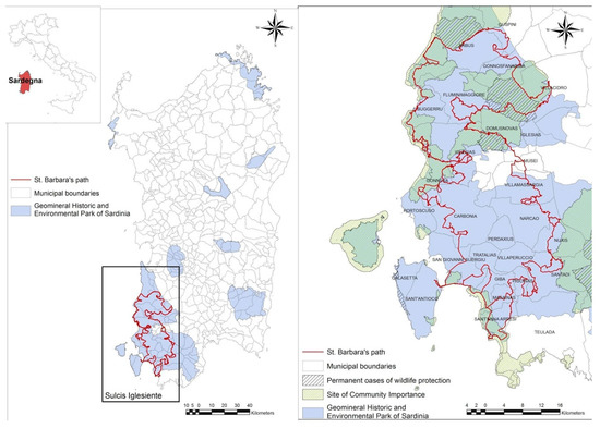
Figure 1.
Santa Barbara Walk (SBW) territorial framework within the Geomineral Historic and Environmental Park of Sardinia and with natural sites.
“Slow tourism” is one of the new trends in contemporary tourism. This trend emerged from the wider trend of the so-called “Slow Movement,” which is characterized by the philosophy of “slow food” and the general philosophy of the “slow city” [61,62]. Slow tourism represents an “antidote” to mass tourism. In such a sense, a feverishly organized trip “to see as much as possible” is replaced by a slow journey of pleasure and relaxation. One of the key elements of slow tourism is the possibility for the traveler to become an active member of the local community and connect with the place and its people, creating stronger memories of the journey and the destination [63]. In other words, the ecological and cultural connectivity and the multifunctionality of ecosystems through slow tourism is consistent both with EU guidelines and with the local context of Sulcis-Iglesiente, characterized by a polycentric landscape, between abandoned mines and sites of environmental interest [46]. In this sense, a reference can be the “European Spatial Planning Observation Network” (ESPON) policy (2016), where the territorial condition requires ‘polycentric development’ as fundamental for sustainable development. Research done by “ESPON”—mapping the ‘polycentricity’ in Europe—illustrates the Iglesiente area with a positive urban structure, composed of small and medium-sized towns, and policy recommendations conclude that the lower density implies more cooperation [64]. This aspect of the network is crucial for the enhancement and use through slow tourism of places and contexts with low urban density.
The official tourism data provided by the Sardinia Region website reveal arrivals and presences in the entire region from 2017 to 2019.The data relating to 2019 was calculated by the authors in accordance with the percentage change estimated by the Sardinia Region compared to the previous year. The comparison shows that the flow of tourism in the Sulcis-Iglesiente confirms the growing regional trend, although it contributes modestly (Figure 2).
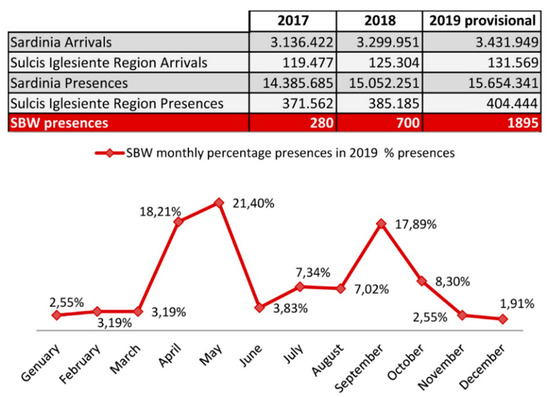
Figure 2.
Comparison between tourist movements in Sulcis-Iglesiente region and in Sardinia in 2017–2018–2019 (provisional). Source Sardinia Region website [65] and Trend of SBW presences (source: SBW Foundation, 2020); percentage trend of monthly presences in the SBW in 2019 (source: SBW Foundation, 2020).
Within this context, the number of SBW users has also grown since 2017, the year of its establishment, affirming this infrastructure as a significant component of the slow tourism offer in Sardinia. Furthermore, the trend of monthly presences shows that this infrastructure promotes the extension of seasonal tourism. In fact, the greatest presence in 2019 was registered in April, May, and September, and not during the months most affected by the typical seaside tourism of Sardinia.
According to these analyses, the strategic role of historical paths and, therefore, also the SBW, should be considered as a driving force in defining a system of green infrastructures at the service of a slow tourist demand, based on knowledge and consistent with the objectives of the 2030 Agenda.
2.2. The Santa Barbara Walk and Its Social Network
The Santa Barbara Walk is an itinerary drawn in the Sulcis-Iglesiente area, in South-Western Sardinia. It follows the traces drawn by mining activities in the past decades in a unique environment as a mining area, located in a beautiful natural landscape. The SBW was brought to new life in sustainable slow tourism through a green infrastructure, characterized by the co-existence of newly drawn trunks of a Walk, the presence of a huge and massive industrial heritage, and the natural characteristics of a territory of particular beauty.
This historical region has, for several decades, been the most important center for international mining, as the main Sardinian economic source. The following crisis hitting the sector, followed by the mines dismantling in the 1990s, required rethinking the territory also through a form of tourism linked to industrial archeology in a particularly beautiful coastal landscape.
Within this context, in October 2001, the Geomineral Historic and Environmental park of Sardinia was established [66], divided into 8 areas covering 81 Municipalities of Sardinia, for a total area of approximately 3800 Km2, which since 2007 is part of the “Global Geoparks Network” of UNESCO [67].The SBW is located within the “area 8” of the Park of Sulcis–Iglesiente which, other than being the largest, is the one most characterized by the presence of ancient mining activities.
In particular, the SBW spans over a complex territory characterized by a complex mining basin, which constitutes the The Geomineral Historic and Environmental park of Sardinia. This territory was the most important district for national and international mining due to its large production of lead and zinc. The crisis in the mining sector and the subsequent closure of the mines in the 1990s left a rich heritage of industrial archeology and infrastructure, as well as a unique landscape. The landscapes of Sulcis-Iglesiente are in fact deeply marked by the consequences of mining activities, with the presence of large open-air and underground excavations, mine adits, tunnels, and numerous mine wastes. The latter are constituted by accumulations of different types of waste rocks and tailings from mines and processing/metallurgical plants. All these elements highlight the vastity of mining operations carried out in the main mining places of the district, such as the great mines of Monteponi, San Giovanni, and Masua, and their related processing plants and handling systems, as the historical Laveria Lamarmora and Porto Flavia plants. The SBW then crosses a landscape rich in natural and anthropogenic elements—landfills, mine muds, and abandoned buildings—but at the same time mutable, because of its vulnerability. This condition of a continuously changing landscape—or landscape in progress—through slow tourism “provides economic, cultural, relational, and social benefits for both visitors and host communities”.
Today, the SBW is included in the regional register of historical-religious paths of Sardinia, and in the year 2017, it was included in the Atlas walk of Italy of the Ministry of Cultural Heritage and Activities [68]. The walk extends along a 400 km ring, organized in 24 ways. It can be traveled walking, cycling, and on horseback [27,32]. The landscape of the SBW is characterized by the presence of numerous points of historical, cultural, and natural interest, enriching the already evocative mining landscape [28,30]. Put in different terms, it can be thought of as a green infrastructure both for the intrinsic aspects—recovery of the old mine tracks—and for the way of travel—walk, bike, and by horse.
However, to date the challenges are still many and constantly call for new policies to manage and enhance the SBW and cultural, natural, and landscape resources.
The main purpose of the SBW is inscribed within the recent slow tourism, characterized by the presence of innovative users, which we consider as a relevant part of the so called “Smart Community”. With the term “community”, we imply that providing user-generated contents, as, in this case, tourists or hikers actually enjoying the Walk and its points of interests, sharing their impressions and activities on social networks. In this particular context, the smart community corresponds to those actors which contribute to the awareness of the SBW by means of their activity on social networks and media and, therefore, they are potential players for its development and growth. The set of social network and media users, from Wikiloc paths collectors, to social networks and media users—both tourists and operators—becomes a pioneer of this SBW smart community. As a matter of fact, a true smart community does not yet exist, but a network of users willing to share their experiences is present. The data coming from this community is a significant input in this work. In the concept of the proposed dashboard, there is the primary object of helping the integration of the top-down management and the bottom up approach of the users. We assume that, using the data and information this community provides, we can build a bottom up participation process, in which the dashboard will represent the extent in which a true smart community is set up, linking together users and decision makers.
3. Methods
After describing the case study of the SBW and the role of its Smart Community, we decided to plan the realization of a dashboard to gather information and indicators on the walk. However, the conceptualization, design, and implementation of the dashboard represents, more importantly, an opportunity for putting all the different elements related to the SBW within a common system and framework, particularly related to the knowledge acquisition of the territory, to be used for planning future actions of territorial promotion. This required developing a methodology for designing the dashboard, articulated in the following phases, consisting of:
- -
- Definition of the conceptual framework to organize the contents of the dashboard, consisting in the collection, analysis, and classification of the intrinsic and extrinsic characteristics of the Walk (Section 3.1), and of the user-generated ones from the smart community—these latter aimed at the production of internal reports for SBW managers (Section 3.2);
- -
- Definition of the layout to organize the contents of the SWB circular dashboard (Section 3.3).
This methodology reflects the conceptual framework of the dashboard we proposed (Figure 3), which is thought of as a collector capable of organizing a comprehensive data set—characteristics and user generated—respectively, we elaborated and collected by the main social networks, as discussed below.
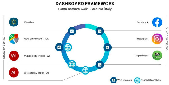
Figure 3.
The Dashboard conceptual framework.
3.1. Survey and Analysis of the Intrinsic and Extrinsic Features of the SBW
Such a methodological phase regards the recognition of the elements that characterize the walk. These are the features of the Walk—intrinsic and extrinsic—but also a specific set of indicators that represent the ‘attributes’ of the same walk—the elements that allow the managers and planners on one side, and users on the other side, to express judgements on the walk’s components.
The data concerning the intrinsic characteristics of the route, which describe the physical conformation of each of the 24 ways, were obtained from the SBW Foundation official website: Length (km), “difficulty”, and duration (hours) (Figure 4).
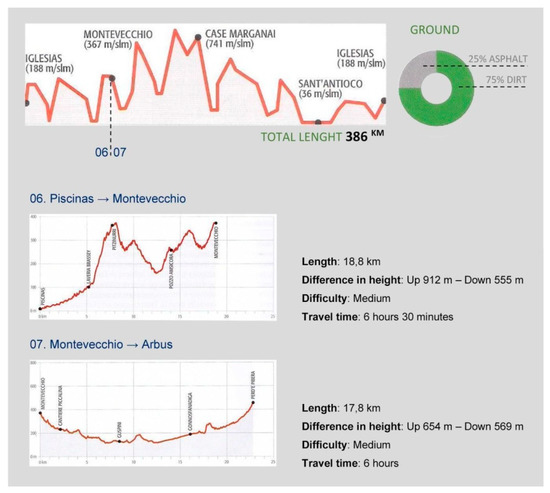
Figure 4.
Intrinsic features of each of the 24 ways: Length (km), “difficulty” and duration (hours). Source: [24,31].
The extrinsic characteristics refer to the points of interest included in a 1 km buffer from the SBW’s ways. These contribute to increasing the attractiveness of the SBW, and, among them, we consider also urban areas as qualifying factors for tourism activities, as well as dynamically linked to the context. The points of interest are classified according to the following categories (Figure 5):
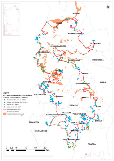
Figure 5.
Points of interest (areas and nodes) within the 1 km buffer from the walk.
- (1).
- Abandoned mining sites (distribution areas and nodes): Villages and mining plants, industrial archeology facilities;
- (2).
- Sites of historical and cultural interest (areas and nodes): Rural and archaeological villages, churches, museums, and historic buildings;
- (3).
- Sites of naturalistic interest (areas and nodes): Natural parks, salt marshes, waterfalls and springs, caves, lakes, beaches, natural monuments;
- (4).
- Urban areas.
In organizing the extrinsic features, referred to the points of interest, we used the open source data from the Sardinia Region in shapefile format [69,70]. Then, we proceeded to classify the intrinsic and extrinsic characteristics, assigning specific score indexes referring to an average evaluation of difficulties:
- (1).
- Intrinsic characteristics—a maximum weight has been assigned for the stages of shorter length, difficulty, and travel time.
- (2).
- Extrinsic characteristics—a maximum weight has been assigned for the stages with the greatest number of points of proximity interest, including accommodation facilities and refreshment points.
Ranges and relative weights have been assigned, taking a non-expert user as a reference, also in consideration of the fact that the SBW is a religious path. Santa Barbara is the patron saint of miners, and veneration has always been very strong since ancient times. In general, the Way of Santa Barbara has been organized for a pilgrim who walks between 5 and 20 km per day. The pilgrim along the paths finds, every 5 km, services to eat or sleep (source: SBW Foundation, 2020).
As the Way was born and is addressed to pilgrims, therefore the weight attributed to the intrinsic characteristics increases with decreasing length, difficulty, and travel time. If for some reason you want to propose to expert walkers the weight attributed to the intrinsic characteristics, it will increase with increasing length, difficulty, and travel time. While the weight of extrinsic characteristics will coincide for both categories of walkers.
Below is reported the classification of intrinsic and extrinsic characteristics (Table 1).

Table 1.
Score index—Intrinsic and Extrinsic characteristics of each SBW way.
This classification then allowed us to elaborate two indexes for each stage: The walkability index (WI), and the attractiveness index (AI). Within the debate on urban walkability [22,71], according to Blečić et al. (2015) [72], we have rethought the definition of walkability, adapting it to the peculiarities of the SBW, inserted in an extra-urban environment, marked by elements from the former industrial processes of considerable landscape value, together with the physical properties of the path and the reference context. As a prerequisite for the realization of the dashboard, and therefore as a knowledge instrument for managers and planners, we hereby propose a walkability index (WI). It is obtained by summing the weights attributed to the individual intrinsic characteristics (Wi), which can vary from a minimum of 3 to a maximum of 8 (1); and the attractiveness index (AI), understood as the sum of the weights attributed to the individual extrinsic characteristics (We), which can vary from a minimum of 3 to a maximum of 12 (2). To standardize the indexes to the more known and used TripAdvisor classification, WI is given by the product between the summation of Wi and the ratio of 5/8; while AI is given by the product between the summation of Wi and the ratio of 5/12.
The following is an example of the ways No. 02, 06, 07, and 21, selected for the application of the methodology because they are characterized by a significant landscape heritage and industrial archeology that makes them among the most attractive of the walk (Figure 6).
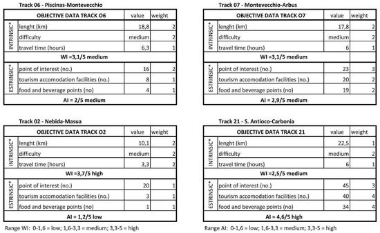
Figure 6.
Walkability index (WI) and Attractiveness index (AI) of the No. 02, 06, 07, and 21 SBW ways.
3.2. Survey and Analysis of the Data Provided by Social Network
The second component of data necessary for the development of the dashboard concerns the user-generated characteristics of the Walk, provided by the smart community. They were found through the main social websites such as Facebook, Instagram, and TripAdvisor, for the main point of interest of the 24 ways, with reference to the abandoned mining sites. In fact, from the analysis of GPS ways related to walking and/or cycling routes downloaded from the Wikiloc platform (SBW’s ways have been downloaded between 20 and 29 January 2018; bike tracks have been downloaded between 21 January and 3 February 2019) [28,29,30], these sites were found to be the most frequented by the smart community [31], as is shown from Figure 7. Furthermore, the disused mining sites were selected as a survey category to evaluate the approval rating of the smart community, which required the following analysis:
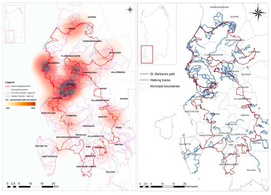
Figure 7.
Comparison between the concentration of disused mining sites and the location of digital tracks (source Wikiloc) from the smart community.
- (1).
- Active Websites for each abandoned mining site (Figure 8);
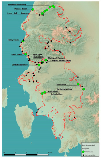 Figure 8. Web Site Map of the mining sites in the SBW. Period of investigation: 1–31 July 2019. Author: Michele Pinna.
 - (2).
- Profiles in the main social web (Facebook, Instagram, and TripAdvisor) (Figure 9, Figure 10 and Figure 11).
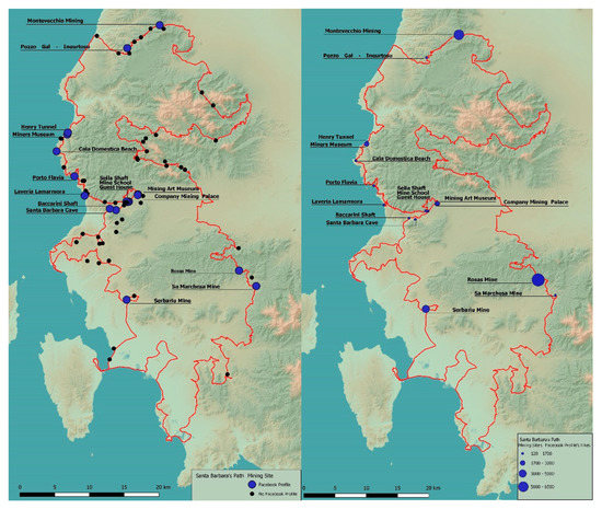 Figure 9. Mining sites with Facebook profile (left) and Facebook Social Rating (right). Period of investigation: 1–31 July 2019. Author: Michele Pinna
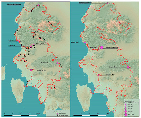 Figure 10. Mining sites with Instagram profile (left) and Instagram followers (right). Period of investigation: 1–31 July 2019. Author: Michele Pinna.
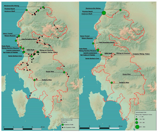 Figure 11. Mining sites with a TripAdvisor profile (left) and TripAdvisor Social Rating (right). Period of investigation: 1–31 July 2019. Author: Michele Pinna.
From the analysis, it emerged that only a minimal part of the abandoned mining sites is equipped with an official web page and a Facebook and/or Instagram profile to support the management and promotion activity (Figure 8, Figure 9 and Figure 10).
In particular, it can be stated that the most important mining sites have a web page and social profiles, while in some cases the social profile is preferred to the website. The analysis confirms that the most significant mining complexes, such as Montevecchio and Serbariu, collect the greatest number of likes on Facebook (Figure 9, right), while the Museum of Mining Art in Iglesias reaches the greatest number of followers on Instagram, followed by the Mine Rosas (Figure 10, right).
The TripAdvisor platform is the main one currently in use at international level. It also provides the satisfaction index associated with the type of user according to its own classification (Figure 11 and Table 2). In this case, Piscinas and Porto Flavia are the sites that have collected the highest number of reviews, and therefore are also the most visited ones.

Table 2.
Matrix of the data provided by the social network (Facebook, Instagram, TripAdvisor) for the Montevecchio Mine Complex. Period of investigation: 1–31 May 2019. Author: Michele Pinna.
An analysis of the data provided implied the organization of the data from social web platforms in a matrix for each individual abandoned mining site. However, here we report only the matrix of social media analysis of the Montevecchio Mine Complex, as it is one of the most appreciated and best managed (Table 2). In fact, the Complex, in addition to having a well-structured and content-rich website, also has Facebook and Instagram profiles, as well as reviews on TripAdvisor. Montevecchio has a high rating on both Facebook (4.6/5) and TripAdvisor (4.5/5). The data provided by TripAdvisor shows that the site is visited mainly during the summer (June-August), and mainly by couples.
All these data reveal the state-of-the-art in terms of tourist promotion activities carried out by each mining site. At the same time, they are useful to inform future management and promote policies of the several points of interest. In particular, while Instagram informs about the number of followers, Facebook also provides the rating manifested by the smart community, along with comments and opinions, which reveal strengths and weaknesses of each point of interest, and therefore guide specific actions. Going beyond the data provided by social networks, Tripadvisor describes each site in terms of community satisfaction, type of visitors, and the visiting period. These data inform, in different cases, about the types of visitors attracted, as well as encourage their presence throughout the year in order to guarantee an extension of the seasonal tourism [29].
3.3. The SBW Dashboard Layout
The classification of the intrinsic and extrinsic characteristics and user generated data of the SBW, as well as the definition of the walkability index (WI) and attractiveness index (AI) for each way, allowed us to develop the design of the SBW circular dashboard. After having framed the recent literature about data, techniques, and platforms of existing Dashboards [73] and Big data dashboards as decision support tools [74], we decided to use the open source Google Sites tools as a framework for developing the dashboard as compatible with the SBW Foundation website, so that the project presented here can be easily implemented and developed in the future. Moreover, we have considered the digital platform dedicated to the Regional Bicycle Mobility Plan of Sardinia [75], from which we extracted the tracks of the walk organized in biking tracks; furthermore, we selected the SBW Foundation website [32] for the walk and horse-riding tracks. The dashboard framework proposed (Figure 3) [76] is thought of as a collector capable of organizing a comprehensive data-set we elaborated and collected through the main social networks, as discussed in this study. It is not yet fully integrated and linked to the existing Foundation website. In the present stage of the research, we did focus on the design of a dashboard, that will support both potential tourists and planners in future decisions for the area and for the Region of Sulcis-Iglesiente.
So, from the design and style point of view, we decided to maintain the general layout of the existing website, in order to allow, once the dashboard is implemented, an easy integration with the existing material. In our vision, the dashboard consists of a homepage of general information of the SBW, and of several specific web pages dedicated to the characteristics of each of the 24 ways. In the figures, we present the dashboard’s proposed structure and a mock-up of the set of data and information for one selected segment of the walk as a demo of the possible contents to be collected, gathered, and shared. The homepage (Figure 12) allows users to select each track and go to the next page.
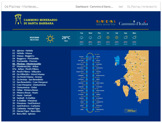
Figure 12.
The SBW Dashboard layout.
The web page dedicated to the track No. 06 Piscinas-Montevecchio (Figure 13), provides four types of geospatial information:
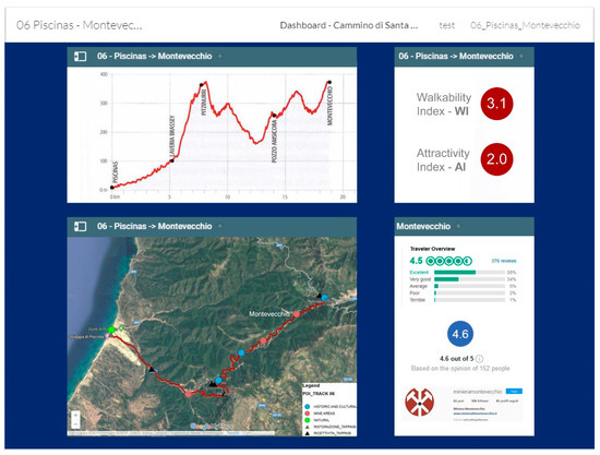
Figure 13.
The web page of the way No. 06 Piscinas–Montevecchio.
- (1).
- Ways and points of interest georeferenced in Google Maps (down on the left);
- (2).
- Physical profile of the way, and its Walkability Index (WI) and Attractiveness Index (AI) (on the top);
- (3).
- Rating provided by the main social networks analyzed (down on the right).
- This will be implemented by means of RESTful API’s as made available by the main social media portals:
- Facebook—https://developers.facebook.com/docs
- Instagram—https://www.instagram.com/developer/
- Instagram does not have ratings, but it has Likes and Followers. Real time photos can be shared on the profile.
- The construction of the dashboard was supported by Iulia Tatomir, Sr. Analyst at Avanade Cagliari, Italy—https://www.avanade.com/en-gb
The system here proposed can be defined as a smart dashboard because it is structured so to provide a constant update on performance indicators, with reference to dynamic information such as the weather, the Attractiveness Index (AI), and the rating provided by the main social networks. This is also a circular dashboard, as it can provide support to public institutions to observe and monitor what happens along the Walk, and the data provided are fundamental to inform future policies.
4. Results and Discussion
The main result of the present paper is the set-up of the organization of information contents on the Santa Barbara Walk—green infrastructure in the Sulcis–Iglesiente (Sardinia, Italy). Such a set of information and data are relevant for allowing tourists and decision makers to gain knowledge on the area and its characteristics: For the former to understand and discover the potentials of such a particular area; for the latter to plan actions for the management of the Walk and targeting initiatives. The idea of proposing a tool for sharing such an amount and kind of information led us to designing a dashboard for management and planning of the tourist offer of the area. Such research is inserted into the “TSulki” project (Tourism and Sustainability in Sulcis-Iglesiente area), currently in progress, regarding the sustainable tourism of the Sulcis-Iglesiente area.
A first result obtained deals with the survey and summary of the characteristics of the area, also in terms of slow tourism and smart tourism. Another result is in terms of gaining a wider awareness and knowledge on some of the characteristics of the SBW and its routes. We developed indexes to better evaluate trunks of the Walk, both for the planner’s benefit and for users, these indexes providing qualitative and quantitative attributes for the same Walk.
The indexes deal with a WI—Walkability Index, based on intrinsic characteristics (as length, difficulty, travel time)—and AI—Attractiveness Index, based on extrinsic characteristics (points of interest, tourism facilities, food and beverage points)—that represent the context of SBW. In addition, the degree of interest was based on the comments and opinions from the community of users for each track coming from the main social networks—Instagram’s followers, and Facebook’s and TripAdvisor’s ratings. Finally, the design of the SBW Dashboard was organized, with both users and decision makers in mind. The results obtained are in terms of a wider knowledge of the SBW, in terms of its intrinsic and extrinsic characteristics, as well as in terms of the perception of a particular subset of the users, as those leaving traces over the social networks and media. The analytical synthesis of these elements represents valuable contents for decision makers to target policies of slow tourism. These elements represent the main data to be summarized and used into the dashboard.
From the design point of view, as Table 3 summarizes, the dashboard is structured to be fed by a combination of data and information. Some main components deal with the fundamental and characterizing elements of the dashboard itself. As suggested above, the WI and AI indexes represent one of the important sources of added value of the project. Their presence at the present stage of development is thought of as a periodical update from the analysts and scholars involved in the SBW project, in the process of constant observation, maintenance, and update of the SBW. The proposed dashboard provides innovative contents and services which cannot be found in existing websites for the promotion of Paths through Italy, also in considering the digital Atlas of Paths developed by the Ministry of Cultural Heritage and Activities (MIBACT). The SBW dashboard has been conceived as a tool capable of collecting, monitoring, and sharing dynamic data such as Walkability Index (WI), Attractiveness Index (AI), and Rating, by direct connections with the main social networks.

Table 3.
SBW Dashboard frame components (authors’ elaboration).
As a matter of fact, further data after a synthetic extraction through API from social network and media contents, can be assigned to the different ways of the SBW. A further level of data input comes from different websites linkable to the dashboard itself: The SBW websites; weather forecast widgets, etc. An extendable set of sources can be thought of in the further evolutions of the dashboards: Further reports generated by experts; other social networks, and media contents and synthesis; links to external websites for information on tourism.
5. Conclusions and Future Development
This paper had, as a main purpose, that of designing a dashboard for the promotion and management of slow tourism, enhancing the potentials of smart tourism in the Santa Barbara Walk (SBW) in the Sulcis–Iglesiente area (Sardinia, Italy).
In particular, we have systematized intrinsic and extrinsic information of the Santa Barbara Walk and developed a series of indices (walkability index and attractiveness index) aimed at increasing awareness and knowledge useful for slow tourism referring to a particular area.
We consider the unique combination of natural and past anthropogenic features related to mining activities as a unique set of elements, making the area an interesting example of landscape in transition, where the combination and interaction of both elements represent a strong element of characterization and attraction of the area for already existing and potential, future tourists. In such a sense, the area is considered as interesting in terms of slow tourism characterization and exploitable by means of smart tourism, whose embryonal elements are already present, in terms of social networks and sharing of information and knowledge among users by means of ICT instruments. That allowed us to obtain an image of the SBW as a green infrastructure, perfectly integrated into the surrounding area. It emerged that it is characterized not only by its physical features, but also by a set of several points of interest in its proximity—those located within a 1 km buffer from the different segments of the walk. Such first results have been expressed in terms of indexes and maps, helping a description and understanding the new slow tourism and the potentials of further development in the area. Such preliminary phase represented a starting point for developing the research methodology, consisting of three main phases.
The first phase was dedicated to the collection, analysis, and classification of the intrinsic and extrinsic characteristics of the walk that allowed developing a Walkability Index (WI) and an Attractiveness Index (AI) for each of the 24 ways. Both of these two indexes are considered useful to describe the different parts of the walk and, therefore, to guide the users’ choice.
The second phase was dedicated to the collection, analysis, and classification of the user-generated characteristics of the points of interest located along the SBW. These data, provided by the SBW’s users through the main social networks (Facebook, Instagram, and TripAdvisor), reveal the state-of-the-art in terms of tourist promotion activities.
The third phase appeared as that dedicated to the systematization of the web info data and the team data analysis to develop a design and a user-friendly graphical interface for the SBW circular smart dashboard. The analyses carried out revealed that a smart community is rising, from the SBW’s users, contributing significantly to the affirmation of a new model of sustainable development based on slow tourism. Awareness and knowledge of history are fundamental to the re-construction of the past. Slow tourism is softly included in the Sulcis-Iglesiente area, free from compulsive mass tourism. The future developments of this study will cover the implementation of the dashboard, also for aspects linked to the safety of the place and the active role of the community of users, to be involved more and more in a bottom up approach in a smart community.
Such initial setup of the characters of the area, of its material and immaterial networks, as well as the designing of the dashboard, put the basis for the future research and actual development of the dashboard itself. This implies the validation of the data and information to be put into the same dashboard. In particular, we will submit the dashboard to a selected group of users, expert and non-expert users, looking forward to its inclusion on the SBW Foundation website and, therefore, usable for the public consultation. We will then proceed with the physical realization of the fully operational dashboard, taking care of the automation of the process of data collection and gathering, particularly of those coming from the social networks and media platforms involved, as well as of those feeding the indicators considered in the dashboard itself. In this sense, the proposed dashboard, including subsequent advances and possible implementations, represents a strategic tool to support the governance and the policies to promote slow tourism in the territory, in order to overcome the deep crisis left by the end of mining activities. The dashboard designed and presented here aims at representing a data, information, and report integrator, facilitating the decision process for both users as tourists and sport practitioners, as they can cross data concerning the quality and characteristics of the ways, the environmental conditions, as well as the comments from the other members of the community of users. From the policy maker’s point of view, the dashboard is useful in providing such information in a dynamic point of view. The frequent reports on the AI and WI indexes, as well as the constant comments and evaluations through social networks and media, will help acquiring a major awareness of the area and of its preferred parts, as well as to highlights those parts where an intervention—of maintenance, major coordination between operators, municipality agreements, etc.—is needed.
The main challenge of this research work lies in the effective collaboration between the different stakeholders involved in the dashboard construction process. Institutions, associations, cooperatives, economic operators, and users are the main players involved in the collection of data from the territory and, consequently, in the definition of the development policies, in line with a sustainable strategic vision of the territory and the local communities’ needs. In fact, as asserted in the introduction, in the area of the Sulcis-Iglesiente, the points of historical-cultural and naturalistic interest, mining sites, reception, and refreshment activities are not managed within a single network. The first attempt to address this condition has been the creation of the website of the SBW Foundation.
Author Contributions
The paper derives from the joint reflections of authors. However, Section 1 and Section 1.1 can be attributed to G.B. (Ginevra Balletto); Section 2.1 to G.B. (Ginevra Balletto); Section 2.2 to A.M.; Section 3 to G.B. (Ginevra Balletto); Section 3.1 to M.L.; Section 3.2 to A.M. and M.L.; Section 3.3 and Section 4 to G.B. (Ginevra Balletto), and Section 5 to G.B. (Giuseppe Borruso). All authors have read and agreed to the published version of the manuscript.
Funding
This research was funded by Foundation of Sardinia (Grant CUP F72F16003160002)—Research project RE-MINE—Restoration and rehabilitation of abandoned mining sites, and by Region of Sardinia, Fundamental or basic research projects for implementation of interventions in the field of research for the ‘Sulcis Plan’ (SULCIS-821319)—Research project TSULKI—Tourism and Sustainability in the Sulcis (Sardinia- Italy).
Conflicts of Interest
The authors declare no conflict of interest.
References
- Kothari, T.; Xiang, Z.; Fesenmaier, D.R. The impact of a marketing information system: A case study of Smart-Baltimore. Inf. Technol. Tour. 2008, 10, 59–74. [Google Scholar] [CrossRef]
- Battino, S.; Balletto, G.; Borruso, G.; Donato, C. Internal Areas and Smart Tourism. Promoting Territories in Sardinia Island. In Proceedings of the International Conference on Computational Science and Its Applications, Melbourne, Australia, 2–5 July 2018; Springer: Berlin/Heidelberg, Germany, 2018; pp. 44–57. [Google Scholar]
- Buhalis, D. Technology in tourism-from information communication technologies to eTourism and smart tourism towards ambient intelligence tourism: A perspective article. Tour. Rev. 2019, 75, 267–272. [Google Scholar] [CrossRef]
- Wan, C.B. Flourishing through smart tourism: Experience patterns for co-designing technology-mediated traveller experiences. Des. J. 2018, 21, 163–172. [Google Scholar] [CrossRef]
- De Lange, M. From real-time city to asynchronicity: Exploring the real-time smart city dashboard. In Time for Mapping; Manchester University Press: Manchester, UK, 2018; pp. 238–255. [Google Scholar]
- Balletto, G.; Borruso, G.; Donato, C. City Dashboards and the Achilles’ Heel of Smart Cities: Putting Governance in Action and in Space. In Computational Science and Its Applications–ICCSA 2018; Gervasi, O., Murgante, B., Misra, S., Stankova, E.N., Torre, C.M., Rocha, A.M.A.C., Taniar, D., Apduhan, B.O., Tarantino, E., Ryu, Y., Eds.; Springer: Berlin/Heidelberg, Germany, 2018; pp. 654–668. [Google Scholar]
- Portney, K.E. Taking Sustainable Cities Seriously: Economic Development, the Environment, and Quality of Life in American Cities; MIT Press: Cambridge, MA, USA, 2013. [Google Scholar]
- Gullino, S. Urban Regeneration and Democratization of Information Access: CitiStat Experience in Baltimore. J. Environ. Manag. 2009, 90, 2012–2019. [Google Scholar] [CrossRef]
- Kitchin, R.; Lauriault, T.P.; McArdle, G. Knowing and governing cities through urban indicators, city benchmarking and real-time dashboards. Reg. Stud. Reg. Sci. 2015, 2, 6–28. [Google Scholar] [CrossRef]
- Batty, M. A perspective on city dashboards. Reg. Stud. Reg. Sci. 2015, 2, 29–32. [Google Scholar] [CrossRef]
- Dameri, R.P. Urban smart dashboard. Measuring smart city performance. In Smart City Implementation; Dameri, R.P., Ed.; Springer: Berlin/Heidelberg, Germany, 2017; pp. 67–84. [Google Scholar]
- Albusaidi, H.S.; Udupi, P.K.; Dattana, V. Integrated data analytic tourism dashboard (IDATD). In Proceedings of the 2016 5th International Conference on Reliability, Infocom Technologies and Optimization(Trends and Future Directions) (ICRITO), Noida, India, 7–9 September 2016; pp. 497–500. [Google Scholar]
- Becken, S.; Miller, G. Global Sustainable Tourism Dashboard; Griffith University: Mount Gravatt, Australia, 2016. [Google Scholar]
- California Institute for Smart Communities. Smart Communities Guide Book; California Institute for Smart Communities: San Diego, CA, USA, 2001. [Google Scholar]
- Nisar, T.M.; Prabhakar, G.; Strakova, L. Social media information benefits, knowledge management and smart organizations. J. Bus. Res. 2019, 94, 264–272. [Google Scholar] [CrossRef]
- Ladu, M.; Balletto, G.; Borruso, G. Sport and Smart Communities. Assessing the Sporting Attractiveness and Community Perceptions of Cagliari (Sardinia, Italy). In Proceedings of the International Conference on Computational Science and Its Applications, Saint Petersburg, Russi, 1–4 July 2019; Springer: Berlin/Heidelberg, Germany, 2019; pp. 200–215. [Google Scholar]
- Barnes, S.J.; Mattsson, J.; Sørensen, F.; Friis Jensen, J. The Mediating Effect of Experiential Value on Tourist Outcomes from Encounter-Based Experiences. J. Travel Res. 2019. [Google Scholar] [CrossRef]
- Romano, F.; La Rocca, R.A. Slow Mobility and Cultural Tourism. Walking on Historical Paths. In Smart Planning: Sustainability and Mobility in the Age of Change; Springer: Berlin/Heidelberg, Germany, 2018; pp. 301–322. [Google Scholar]
- Calzati, V. Nuove Pratiche Turistiche e Slow Tourism. Il Caso Della Valnerina in Umbria; Franco Angeli: Milan, Italy, 2016. [Google Scholar]
- Agarwal, S.; Busby, G.; Huang, R. Slow tourism. In Special Interest Tourism: Concepts, Contexts and Cases; CABI: Wallingford, UK, 2017; pp. 183–195. [Google Scholar]
- Tomić, S.; Leković, K.; Stoiljković, A. Impact of motives on outcomes of the travel: Slow tourism concept. Školabiznisa 2018, 2, 68–82. [Google Scholar] [CrossRef]
- Beretić, N.; Plaisant, A. Setting the Methodological Framework for Accessibility in Geo-Mining Heritage Settings—An Ongoing Study of Iglesiente Area (Sardinia, Italy). Sustainability 2019, 11, 3556. [Google Scholar]
- Beretić, N.; Cecchini, A.; Đukanović, Z. Geotourism as a Development Tool of the Geo-mining Park in Sardinia. Geoheritage 2019, 11, 1689–1704. [Google Scholar] [CrossRef]
- Jelen, J. Mining Heritage and Mining Tourism. Czech J. Tour. 2018, 7, 93–105. [Google Scholar] [CrossRef]
- Menne, A. La Via Francigena–Tanta Vita–A piedi da Milano a Roma; Edizioni Menne Antonino: Milan, Italy, 2019. [Google Scholar]
- Perelli, G.; Sistu, G. Abitare il tempo... libero. Il sogno probabile del turismo minerario in Sardegna. In Dove Finisceil Mare; Iorio, M., Sistu, G., Eds.; Sandhi Editore: Cagliari, Italy, 2010; pp. 361–374. [Google Scholar]
- Pinna, G. Il Cammino Minerario di Santa Barbara.A Piedi in Sardegna tra Storia e Natura; Terre di Mezzo: Milan, Italy, 2017. [Google Scholar]
- Balletto, G.; Milesi, A.; Battino, S.; Borruso, G.; Mundula, L. Slow tourism and smart community. The case of Sulcis -Iglesiente (Sardinia -Italy). In Computational Science and Its Applications-ICCSA 2019; Misra, S., Gervasi, O., Murgante, B., Stankova, E., Korkhov, V., Torre, C., Rocha, A.M., Taniar, D., Apduhan, B., Tarantino, E., Eds.; Springer: Berlin/Heidelberg, Germany, 2019; pp. 184–199. ISBN 978-3-030-24310-4. [Google Scholar]
- Balletto, G.; Milesi, A.; Mundula, L.; Borruso, G. Wave, walk and bike tourism. The case of Sulcis (Sardinia-Italy). In Planning, Nature and Ecosystem Services; Gargiulo, C., Zoppi, C., Eds.; FedOAPress: Naples, Italy, 2019; pp. 881–892. [Google Scholar]
- Balletto, G.; Milesi, A.; Naitza, S.; Mundula, L.; Borruso, G. Smart community and landscape in progress. The case of the Santa Barbara walk (Sulcis, Sardinia). In Planning, Nature and Ecosystem Services; Gargiulo, C., Zoppi, C., Eds.; FedOAPress: Naples, Italy, 2019; pp. 893–903. [Google Scholar]
- Dickinson, J.; Lumsdon, L. Slow Travel and Tourism; Earthscan: London, UK, 2010. [Google Scholar]
- Cammino Minerario di Santa Barbara Web Site. Available online: https://www.camminominerariodisantabarbara.org/ (accessed on 15 September 2019).
- WTO COVID-19: PUTTING PEOPLE FIRST, World Tourism Organization. Available online: https://www.unwto.org/tourism-covid-19-coronavirus (accessed on 25 March 2020).
- Burke, M.; Auffhammer, M.; Burney, J.; Hsiang, S.; Lobell, D.; Roberts, M.; Schlenker, W. COVID-19 Reduces Economic Activity, Which Reduces Pollution, Which Saves Lives. G-FEED (Global Food, Environment and Economic Dynamics). Available online: http://www.g-feed.com/2020/03/covid-19-reduces-economic-activity.html (accessed on 25 March 2020).
- Li, R.; Pei, S.; Chen, B.; Song, Y.; Zhang, T.; Yang, W.; Shaman, J. Substantial Undocumented Infection Facilitates the Rapid Dissemination of Novel Coronavirus (SARS-CoV2). Science 2020. [Google Scholar] [CrossRef] [PubMed]
- Setti, L. SIMA, Università di Bologna e Bari. Relazione Circa l’effetto Dell’inquinamento da Particolato Atmosferico e la Diffusione di Virus Nella Popolazione. Available online: http://www.simaonlus.it/wpsima/wp-content/uploads/2020/03/COVID19_Position-Paper_Relazione-circa-l%E2%80%99effetto-dell%E2%80%99inquinamento-da-particolato-atmosferico-e-la-diffusione-di-virus-nella-popolazione.pdf (accessed on 25 March 2020).
- Roussel, I. Extreme Weather Events and Air Pollution Peaks in the Light of Climate Change: The Limits of the Notion of Risk. In Extreme Weather Events and Human Health; Springer: Berlin/Heidelberg, Germany, 2020; pp. 59–78. [Google Scholar]
- Jacob, D.J.; Winner, D.A. Effect of climate change on air quality. Atmos. Environ. 2009, 43, 51–63. [Google Scholar] [CrossRef]
- Setti, A.F.F. Climate Change, Human Health, and Sustainable Development. Clim. Action 2019, 2020, 253–263. [Google Scholar]
- Kienast, F.; Helfenstein, J.; Grêt-Regamey, A.; Haines-Young, R.; Potschin, M. Ecosystem Services under Pressure. In Landscape Planning with Ecosystem Services; Springer: Berlin/Heidelberg, Germany, 2019; pp. 91–101. [Google Scholar]
- Blum, J. Contribution of ecosystem services to air quality and climate change mitigation policies: The case of urban forests in Barcelona, Spain. In Urban Forests; Apple Academic Press: Palm Bay, FL, USA, 2017; pp. 21–54. [Google Scholar]
- Bolund, P.; Hunhammar, S. Ecosystem services in urban areas. Ecol. Econ. 1999, 29, 293–301. [Google Scholar] [CrossRef]
- Saarinen, J. Communities and sustainable tourism development: Community impacts and local benefit creation in tourism. In A Research Agenda for Sustainable Tourism; Edward Elgar Publishing: Cheltenham, UK, 2019. [Google Scholar]
- Wu, D.; Shen, C.; Wang, E.; Hou, Y.; Yang, J. Impact of the Perceived Authenticity of Heritage Sites on Subjective Well-Being: A Study of the Mediating Role of Place Attachment and Satisfaction. Sustainability 2019, 11, 6148. [Google Scholar] [CrossRef]
- De Salvo, P.; Calzati, V.; Soglia, S. Value for Time: Slowness, a Positive Way of Performing Tourism. In Best Practices in Hospitality and Tourism Marketing and Management; Springer: Cham, Switzerland, 2019; pp. 315–336. [Google Scholar]
- Shang, W.; Qiao, G.; Chen, N. Tourist experience of slow tourism: From authenticity to place attachment–a mixed-method study based on the case of slow city in China. Asia Pac. J. Tour. Res. 2020, 25, 170–188. [Google Scholar] [CrossRef]
- Flemming, S. The Geographies of Social Networks and Innovation in Tourism. Tour. Geogr. 2017, 9, 22–48. [Google Scholar]
- Battino, S.; Lampreu, S. The Role of the Sharing Economy for a Sustainable and Innovative Development of Rural Areas: A Case Study in Sardinia (Italy). Sustainability 2019, 11, 3004. [Google Scholar] [CrossRef]
- Buhalis, D.; Amaranggana, A. Smart Tourism Destination. In Information and Communication Technologies in Tourism 2014; Xiang, Z., Tussyadiah, I., Eds.; Springer: Berlin/Heidelberg, Germany, 2013; pp. 553–564. [Google Scholar]
- Cohen, E. Authenticity and commoditization in tourism. Ann. Tour. Res. 1988, 15, 371–386. [Google Scholar] [CrossRef]
- Weidinger, T. Encountering local inhabitants’ perspectives in terms of authenticity: The example of rural tourism in Southern Germany. DosAlgarves 2015, 25, 4–24. [Google Scholar]
- Costanza, R.; D’Arge, R.; De Groot, R.; Farber, S.; Grasso, M.; Hannon, B.; Limburg, K.; Naeem, S.; O’Neill, R.V.; Paruelo, J.; et al. The value of the world’s ecosystem services and natural capital. Nature 1997, 387, 253–260. [Google Scholar] [CrossRef]
- Leone, F.; Zoppi, C. Ecosystem services as external drivers in the Strategic environmental assessment of management plans of the sites of the Natura 2000 network. Urban. Inf. 2015, 42, 34–38. [Google Scholar]
- Lai, S.; Leone, F.; Zoppi, C. Implementing Green Infrastructures beyond Protected Areas. Sustainability 2018, 10, 3544. [Google Scholar] [CrossRef]
- Leone, F.; Zoppi, C. Local Development and Protection of Nature in Coastal Zones: A Planning Study for the Sulcis Area (Sardinia, Italy). Sustainability 2019, 11, 5095. [Google Scholar] [CrossRef]
- Fetzer, T.; Hensel, L.; Hermle, J.; Roth, C. Coronavirus Perceptions and Economic Anxiety. Available online: https://arxiv.org/pdf/2003.03848.pdf (accessed on 25 April 2020).
- Murgante, B.; Borruso, G. Smart cities or dumb cities? Smart communities, city dashboard e social network analysis. GEOmedia 2015, 18, 994. [Google Scholar]
- Cannas, I.; Lai, S.; Leone, F.; Zoppi, C. Green infrastructure and ecological corridors: A regional study concerning Sardinia. Sustainability 2018, 10, 1265. [Google Scholar] [CrossRef]
- European Union. Available online: https://eur-lex.europa.eu/legal-content/IT/TXT/PDF/?uri=CELEX:52019DC0236&qid=1562053537296- (accessed on 25 March 2020).
- Estreguil, C.; Dige, G.; Kleeschulte, S.; Carrao, H.; Raynal, J.; Teller, A. Strategic Green Infrastructure and Ecosystem Restoration: Geospatial Methods, Data and Tools; EUR 29449 EN; Publications Office of the European Union: Brussels, Belgium, 2019.
- Turrell, E.C. Taking Time: Craft and the Slow Revolution. Available online: http://takingtime.org/ (accessed on 25 March 2020).
- Çiçek, M.; Ulu, S.; Uslay, C. The Impact of the Slow City Movement on Place Authenticity, Entrepreneurial Opportunity, and Economic Development. J. Macromark. 2019, 39, 400–414. [Google Scholar]
- Serdane, Z.; Maccarrone-Eaglen, A.; Sharifi, S. Conceptualising slow tourism: A perspective from Latvia. Tour. Recreat. Res. 2020, 1–14. [Google Scholar] [CrossRef]
- European Route of Industrial Heritage. Available online: https://www.erih.net/fileadmin/Mediendatenbank/Downloads/Membership-Forms_en/ERIH_Membership_Brochure.pdf (accessed on 26 February 2020).
- Sardinia Region Web Site. Available online: http://dati.regione.sardegna.it/dataset/movimenti-turistici-in-sardegna-2018-per-comune (accessed on 25 March 2020).
- Parco Geominerario Web Site. Available online: http://www.parcogeominerario.eu/ (accessed on 15 September 2019).
- UNESCO Web Site. Available online: http://www.unesco.org/new/en/natural-sciences/environment/earth-sciences/ (accessed on 15 September 2019).
- Ministero Delle Politiche Agricole Alimentari Forestali e del Turismo Web Site. Available online: https://www.turismo.politicheagricole.it/home-cammini-ditalia/ (accessed on 15 September 2019).
- Sardinia Region Web Site. Available online: http://webgis2.regione.sardegna.it (accessed on 15 September 2019).
- Sardinia Region Web Site. Available online: http://dati.regione.sardegna.it/dataset (accessed on 15 September 2019).
- Congiu, T.; Blečić, I.; Cecchini, A.; Fancello, G.; Talu, V.; Trunfio, G.A. Prospettive di sviluppo nella ricerca sulla camminabilità. Urban. Inf. 2015, 263, 9–12. [Google Scholar]
- Blečić, I.; Cecchini, A.; Fancello, G.; Talu, V.; Trunfio, G.A. Walkability and urban capabilities: Evaluation and planning decision support//Camminabilità e capacità urbane: Valutazione e supporto alla decisione e alla pianificazione urbanistica. Territ. Italia 2015, 1, 51–66. [Google Scholar] [CrossRef]
- Mauricio, R.; Guachi, T. Dashboard Design to Assess the Impact of Distinct data Visualization Techniques 852 in the Dynamic Analysis of Survey’s Results; Polytechnic Institute of Leiria: Leiria, Portugal, 2018. [Google Scholar]
- Kourtit, K.; Nijkamp, P. Big data dashboards as smart decision support tools for i-cities–An experiment 843 on Stockholm. Land Use Policy 2018, 71, 24–35. [Google Scholar] [CrossRef]
- SardegnaCiclabile Web Site. Available online: http://www.sardegnaciclabile.it (accessed on 15 September 2019).
- Balletto, G.; Borruso, G.; Milesi, A.; Ladu, M. Turismo lento nel Sulcis Iglesiente. Mappe di comunità per le sfide dello sviluppo turistico locale. In Proceedings of the XXIII National Conference ASITA, Trieste, Italy, 12–14 November 2019; pp. 595–602. [Google Scholar]
© 2020 by the authors. Licensee MDPI, Basel, Switzerland. This article is an open access article distributed under the terms and conditions of the Creative Commons Attribution (CC BY) license (http://creativecommons.org/licenses/by/4.0/).