Abstract
In recent years, Cinque Terre National Park, one of the most famous UNESCO sites in Italy, experienced a significant increase in tourist visits. This unique landscape is the result of the rough morphology of a small coastal basin with a very steep slope and a long-term human impact, mainly represented by anthropic terraces. This setting promotes the activation of numerous geo-hydrological instabilities, primarily related to heavy rainfall events that often affect this area. Currently, the main challenge for the administrators of Cinque Terre National Park is the correct maintenance of this environment along with the functional management of the hiking trail to ensure the safety of tourists. The definition of a methodology for effective management is mandatory for the sustainable administration of this unique site. We implement a new codified procedure based on the combined use of the Operative Monography and the Survey Form, focusing on the “Sentiero Verde-Azzurro” trail, for a proper description of the known landslides affecting the trail and the identification of damage and/or landslides activated by critical meteorological events. This guarantees effective geo-hydrological risk management, which is also applicable to other similar sites in a unique environmental and cultural heritage site such as Cinque Terre Park.
1. Introduction
Geo-hydrological instabilities, commonly associated with heavy or prolonged rainfall, often cause damage and casualties throughout the entire Italian territory [1,2]. These processes not only have a strong impact on urban areas but also cause severe damage to natural sites such as the Cinque Terre National Park, which was affected by a severe flood in 2011 [3].
In the international scene, the need for an effective administration through a sustainable development model of touristic places, featuring a great cultural and geo-heritage interest is increasingly evident [4,5,6]. The Cinque Terre National Park, established in 1999, is one of the most famous and visited parks in Italy. The name Cinque Terre refers to five medieval villages with economies previously based on agriculture and fishing, and today, these villages mainly depend on tourism. The villages, namely Monterosso al Mare, Vernazza, Corniglia, Manarola and Riomaggiore, are located along a jagged rocky coastline approximately 20 km in length in the easternmost sector of the Liguria Region (north-western Italy).
The Cinque Terre National Park area, covering approximately 38 km2, despite the seaside location, displays a prevalently hilly mountainous environment with an altitude ranging from sea level to approximately 800 m a.s.l. This area is characterized by a series of southwest-facing small catchments with very steep slopes, limiting in some cases narrow coastal plains and often reaching directly to the shoreline, which is mainly shaped by rocky cliffs. This morphological setting promotes the activation of diverse geo-hydrological instabilities, especially during flash floods that frequently affect the area [7,8].
In 1997, the Cinque Terre area became a World Heritage Site, described as “a cultural landscape of great scenic and cultural value, with a layout and disposition of the small towns and the shaping of the surrounding landscape, overcoming the disadvantages of a steep, uneven terrain, encapsulating the continuous history of human settlement over the past millennium” [9]. In fact, this unique coastal landscape exhibits a long-term human land use history, mainly represented by agricultural terraces. Since 2018, agricultural terraces have been included in the Representative List of Intangible Cultural Heritage of Humanity [10]. The Cinque Terre landscape is almost completely occupied by agricultural terraces (approximately 60% of the entire park [11,12]) built since the Middle Ages and mainly consisting of dry-stone walls supporting a flat portion prevalently cultivated with vineyards and, to a lesser extent, with olive groves.
Starting from the first half of the last century, a progressive abandonment of agricultural activities, with a consequent lack of the maintenance of the dry-stone walls, led to widespread land degradation processes [3,13,14]. The effects of land degradation are forcefully exhibited in the case of heavy rainfalls and severe storms when shallow landslides and debris flows often occur. The presence of slope instabilities is a common feature not only of the Cinque Terre area but also of the whole territory of the Liguria region, where the effects of slope processing, climate changes, infrastructure and human modification are strictly related [15,16,17,18,19,20,21,22,23]. Recent studies focused on the Cinque Terre area noted the relationships between the degree of the abandonment of the terraces and the magnitude of rainfall-induced shallow landslides [24,25,26,27,28].
The Cinque Terre National Park is crossed by an extensive trail network, including both ridge trails and coastal hiking trails, walked by hundreds of thousands of tourists every year (e.g., 397,000 people were counted on the “Sentiero Verde Azzurro” (SVA) during 2016 [29]). Numerous landslides affect the territory of the Park [8,30,31], among which rainfall-induced landslides are the most widespread. Rock falls and degradation scarps are widespread along the eastern portion of the coastline, while large landslides with a complex style of activity are less abundant, e.g., the Guvano landslide, just below the San Bernardino hamlet, the Macereto area close to Vernazza, and the Rodalabia landslide located between the hamlets of Corniglia and Volastra [30,32].
In the literature, an in-depth analysis of the Vernazza catchment, the largest coastal basin within the Cinque Terre National Park, was performed after a flood event occurred on 25 October 2011 [15,24,33]. Starting from the first geographic analysis of the intersection between geo-hydrological phenomena and the Cinque Terre National Park trails [8], we noticed that a detailed analysis of the actual and potential impacts of slope instabilities on the trails was still missing.
In the Cinque Terre area, as well as in other tourist sites with strong cultural and natural elements of attraction, a comprehensive assessment of geo-hydrological instabilities becomes necessary for effective risk management to safeguard human life and to preserve these unique landscapes. In this paper, we present an interdisciplinary methodology based on the combined use of Operative Monographies (OMs) [34] and “Survey Forms” (SFs) to ensure safety along the most visited trails of the Cinque Terre National Park and thus reduce landslide risk. OMs are a useful tool for providing an overview of available data on certain areas or processes along the trails in a standard format that can be repeated and updated over time, ensuring a comprehensive knowledge of the investigated area. SFs, proposed by the Geological Risks Study Centre (GRSC) of the Cinque Terre National Park, provide during field survey campaigns a pre-defined format to identify and detect geo-hydrological instabilities triggered by severe meteorological events. The combined use of OMs and SFs is the basis of a methodology developed to define a codified procedure for the management of the Cinque Terre National Park trails network, which may be potentially affected by the activation/reactivation of slope instabilities in the cases of intense and/or prolonged rainfall events.
This procedure represents the first attempt at a national scale to define a standard approach that codifies actions, operators, and responsibilities for better management of the geo-hydrological risk assessment and the development of mitigation strategies along hiking trails or other human-related sites that are adaptable elsewhere in other natural and protected environments. The new methodology has been developed and tested on one of the most heavily visited trails of Cinque Terre: the “Sentiero Verde-Azzurro” (SVA). This trail connects Monterosso al Mare to Riomaggiore through a landscape characterized by vineyards, olive groves and woods, almost completely occupied by abandoned terraces, and along some tracts crossing some of the most relevant and well-known landslides of the National Park [35,36].
Currently, the SVA trail is developed within a fragile environment that suffers from severe slope degradation issues coming from widespread landslide phenomena and, in some cases, erosional processes. The choice of the SVA trail is not fortuitous because this trail every year records a high number of hikers (approximately 358,000 passages in 2017 and 363,000 in 2018), resulting in the most visited part of Cinque Terre and one of the most visited sites in Italy.
The main goals of this work are (i) the identification of the possible impact of recognized geo-hydrological processes on the SVA trail; (ii) the collection of existing bibliographical sources and the production of OMs; (iii) the development of a procedure for the identification of rainfall-induced geo-hydrological processes and damage based on the combined use of OMs and SFs; and (iv) the evaluation of the added value arising from the use of the proposed methodology for more effective management of the hiking trails.
A correct geo-hydrological risk management in such areas, due to its significant cultural and geological heritage, together with the high number of tourists and the high human impact, could represent a great challenge for the National Park authority to enhance a sustainable use of the territory, as well as being an interesting example for similar sites.
2. Study Area
This work concerns a section of the SVA trail, one of the most frequented and popular hiking paths of the Cinque Terre National Park. This park represents a renowned cultural and geological heritage known worldwide and visited by millions of tourists every year. The SVA trail extends for approximately 11.1 km along the seaside, from the hamlet of Monterosso al Mare to Riomaggiore (Figure 1), in the eastern Liguria Region of north-western Italy.
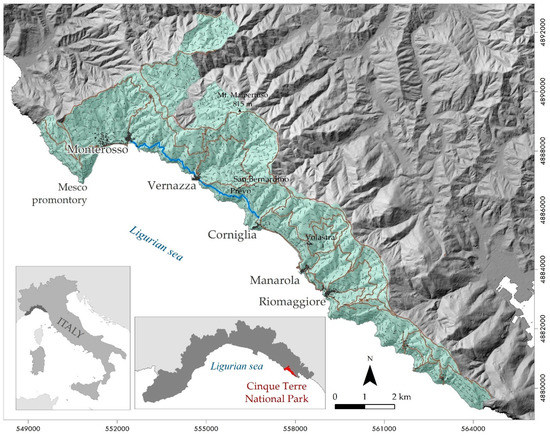
Figure 1.
Map of the investigated portion of the “Sentiero Verde-Azzurro” trail (light blue line), located within the Cinque Terre National Park (teal polygon), Liguria Region, north-western Italy. The entire path network of the national park is indicated in light brown.
The SVA trail crosses several small coastal basins (Figure 2a), whose areas range from 3.75 to 573.6 hectares, generally impacted by erosional phenomena and characterized by high levels of geo-hydrological risk. The main geomorphic features of the territory are the closeness to the sea of the Cinque Terre/Vara valley watershed (highest elevation of 815 m a.s.l., Mt. Malpertuso), and the high steepness of the southwest-oriented (Figure 2b) slopes facing the Ligurian Sea, ranging from 35° to more than 45° (Figure 2c). Slopes are mainly covered by thin layers of eluvial-colluvial deposits [37].

Figure 2.
Map of the investigated portion of the “Sentiero Verde-Azzurro” trail (dotted blue line): a. number of catchments crossed by the trail, associated with the relief terrain map, b. aspect plot, c. slope bar diagram; d. lithological map, and e. land use map of the area of interest. All the vector data and the digital terrain model are available and downloadable in the Geoportal of the Liguria Region [40].
From a geological point of view, the most widespread rock types are the Macigno Formation (upper Oligocene) and the Canetolo Unit, belonging to the Tuscan Nappe and the Sub-Ligurian Domain, respectively (Figure 2d) [38]. The Macigno Formation crops out along the entire coast and in the internal portion of the study area and consists mainly of sandstone and claystone flysch. Instead, the Canetolo Unit crops out in the central portion of the study sector and is represented by the Canetolo shale and limestone formations (claystone with limestones and silty sandstone turbidites of Paleocene age), which is associated with the Groppo del Vescovo limestone formation (marly limestone with claystone interlayers of early-middle Eocene age) and the Ponte Bratica sandstone formation (fine sandstone turbidites of upper Oligocene age). Localized outcroppings of the Marra Unit (silty marls and siltstones of the T. Pignone Formation of Oligocene age), part of the Sub-Ligurian Domain, are located in the middle of the study area.
The tectonic setting is characterized by a wide overturned antiform fold (La Spezia fold) characterized by southwestern Thyrrenian vergence and a series of main direct faults with the NW-SE, SW-verging antiform fold and by main NW-SE-oriented faults intersecting with perpendicular, NE-SW-oriented strike-slip faults, highly influencing the drainage pattern, as well as the coastline orientation [39].
The land use setting of the study area exhibits a distinctive human-modified landscape characterized by agricultural terraces, mainly for vineyard and olive grove cultivation (Figure 2e). These land portions bounded by dry-stone walls occupy the majority of the study area, notably the Vernazza catchment, land of Cinque Terre DOC (a blend of Vermentino, Bosco and Albarola grapes) and “Sciacchetrà” renowned wine production. Despite the wide extension of terraced areas, the preservation and maintenance of these anthropic features is currently lacking or poor, thus giving a strong contribution to the onset geomorphological instabilities (e.g., the local collapse of dry-stone walls and small rotational slides involving the terraces). Additionally, the progressive abandonment of agricultural activities over the last sixty years enhanced a progressive recolonization by Mediterranean shrubs, herbaceous vegetation and forest tree species. The degree of dry-stone wall degradation, strongly related to the abandonment of agricultural practices along the terraces, is strictly correlated with rainfall-induced shallow landslide occurrence [25].
In addition, such coastal stretching is characterized by widespread rock falls and degradation scarps along the SVA trail. Some known large dormant or relict landslides cross the trail, such as (i) the Guvano landslide, a complex slide extended from the San Bernardino hamlet (350 m a.s.l.) to the seaside and currently monitored by a series of permanent GNSS stations [32,41]; (ii) the Macereto area, an extended area affected by widespread rock falls, in several sectors stabilized with different slope protection measures (e.g., rockfall barriers and gabionades) [30]; (iii) the Vernazza rock planar slide, stabilized with a set of hobnails [30].
3. Methods
In this paper, a new approach for investigating the instability proneness of the area of interest, with respect to both natural and anthropic causal factors, is employed. We analysed a stretch of the SVA trail to provide an effective procedure for managing the geo-hydrological risks along the trail. Figure 3 shows the overall methodology. Initially, the potential geo-hydrological hazards of the area of interest were identified, considering both natural and anthropogenic sources. A field survey was carried out along the SVA trail. Jointly, collection and organization of historical data has been performed. All obtained data converged in the Operative Monographies (OMs), a recent tool for data collection based on a standard structure [34]. When adverse weather conditions occur, the procedure provides for a field survey along the hiking path with the compilation of a predefined Survey Form (SF). By combining OMs and SFs, a specific procedure adaptable to different possible scenarios was implemented to ensure useful risk management.
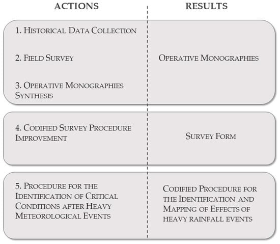
Figure 3.
Methodology scheme.
3.1. Historical Data Collection
The collection and analysis of previous information available for the most dangerous landslides observed within the Cinque Terre National Park was carried out. By referring to a previous inventory, such as the National Landslide Inventory [42] and recent research [8], a landslide inventory of the area of interest was immediately available. This inventory was then compared with data acquired by a dedicated field survey. Focusing on the main recognized landslides, we carried out accurate scientific literature research, analysing all available data and information (e.g., geological and geomorphological maps and deformation measurements). In recent years, the GRSC of the Cinque Terre National Park progressively improved its internal archive by collecting previous scientific and technical studies.
3.2. Field Survey
A dedicated field survey was carried out by a group of expert geologists following the SVA path from Monterosso al Mare to Corniglia. The survey was completed by a detailed inspection of the studied area by boat. The waterborne survey was useful to acquire a comprehensive view of existing landslides, which are only partially visible along the trail. Furthermore, exposure to wave erosion represents one of the factors that can activate or increase slope instabilities. Natural and anthropic evidence interacting with the trail was inventoried. We considered all the potential geo-hydrological hazards noticeable in both the upstream and the downstream sides, including: (i) main landslides; (ii) rock fall-prone areas; (iii) headward erosion; (iv) degradation scarps; (v) local dry-stone wall collapses; and (vi) drainage network failures.
Taking advantage of a simple free app for tracking (i.e., “Trimble Outdoor”), we recorded and collected the points of interest associated with geocoded images taken directly from smartphones. Eleven critical points were identified, considering not only the main landslides affecting the trail but also the sectors of potential geo-hydrological hazards arising from the poor management of drainage networks, slope erosion, and degradation scarps. In addition, the partial or complete interruption of the path, mainly due to anthropic terrace collapses caused by lack or poor maintenance, was also taken into account. The acquired data were then quickly managed and organized in Operative Monographies.
3.3. Operative Monographies Synthesis
The Operative Monography is a document developed to provide guidance for the effective management of information on large and complex landslides [34]. This document is a useful tool for public security purposes, providing a brief, constantly updated overview of a single hazardous phenomenon located in a highly vulnerable area. The OM is a standardized and easily readable document that allows immediate access to historical data related to a specific area or a geo-hydrological phenomenon. OMs provide codified overviews that highlight key information as well as potential critical elements emerging from the analyses of the considered phenomena. The structured scheme, characterized by a standard format, is divided into different sections: (i) general information on the unstable area, (ii) the analysis and organization of available data, (iii) ground deformation time series analysis, and (iv) synthesis and possible proposals. The first section reports the basic information on the considered area or phenomenon (e.g., geographical location, type and state of activity). The second section contains an in-depth analysis of the existing historical information, focusing mainly on the geological, structural, geomorphological and hydrogeological aspects. The third section focuses on the analysis of ground deformation measurements derived from the monitoring network, if existing, for long-term evolution analysis. The last section provides a brief summary of the available data, highlighting the potential missing information and criticalities, and jointly providing several technical suggestions to overcome the identified issue.
This standardized approach ensures that future data will be organized with a consistent approach, limiting possible mismatch with previous studies. In addition, the standardized structure can be easily updated over time and, if necessary, modified for the analysis of diverse geo-hydrological processes and/or unstable areas.
In this work, we customized the OM structure by adding a section dedicated to the assessment of the degree of interference between the recognized geo-hydrological processes and the SVA trail. The adopted OM structure is as follows:
- General information on the unstable area.
- Analysis and organization of previous data, divided into sub-sections:
- Photographic evidence;
- Geological and geomorphological aspects;
- Analysis of previous work.
- Analysis of potential interference between geo-hydrological processes and the SVA trail.
- Monitoring system analysis.
- Summary and final proposal.
In this way, the revision of the OMs integrates the available material from the historical data collection with field survey observations. The OM facilitates the characterization of the SVA trail through the assessment of the geo-hydrological risks along the entire path and the definition of the state of knowledge of each recognized hazard. This document also represents a useful tool during emergencies when quick and effective access to the available historical data is fundamental for geo-hydrological risk management.
3.4. Codified Survey Procedure Improvement
The occurrence of numerous floods during the recent decades highlighted how disruptive these events could be, particularly for environmental and cultural heritage [43]. In the study area, one of the most recent and severe floods occurred on 25 October 2011 in response to extreme rainfall [3,27]. In the Mediterranean area, this event represents one of the most severe rainstorms in recent years, in terms of both rainfall intensities and cumulative rain quantities [44,45,46,47]. This rainstorm was responsible for intense erosive processes and triggered numerous shallow landslides that increased the sediment yield and the power of flow along streams, leading to severe flash floods of the hamlets of Monterosso al Mare [27] and Vernazza [3]. The amount of economic and structural damage was relevant both for villages and people. Moreover, many terraces were disrupted, and some stretches of the hiking trail were affected by landslides, causing the closure of part of the trail network. After such a disastrous event, according to the land management strategies adopted by some local municipalities, numerous remedial works were planned to stabilize the most unstable slopes and the most problematic stream segments [33,48]. On slopes, several types of solutions have been adopted to reduce rain-wash effects and to consolidate the areas affected by shallow landslides. Moreover, reinforcements of dry-stone walls were also performed. On the other hand, along streams, most of the interventions were carried out with the aim of improving flows and restoring the former flow sections. Geo-hydrological risk mitigation measures allowed the restoration of hiking paths and related facilities to give tourists the opportunity to visit this beautiful and unique environment. In recent years, the GRSC has promoted multidisciplinary studies and activities aimed at examining the state of the conservation, efficiency and damage of both geo-hydrological risk mitigation measures and hiking paths after the occurrence of severe rainstorms. A survey form (SF) has been implemented to properly support the work of surveyors after severe hydro-meteorological events. The adopted SF allows an effective and fast inventory of damage and rainfall-induced hydro-geomorphological effects along the hiking trail. This procedure is expected to provide a useful contribution in terms of civil protection measures by decreasing the exposure of trail users to geo-hydrological risk.
3.5. Procedure for the Identification of Critical Conditions after Heavy Meteorological Events
In areas with a very high number of tourists, such as the Cinque Terre National Park, when particularly adverse weather conditions occur, it becomes necessary to verify the accessibility of the path network. In addition, the identification of any critical issue along the trails requires the planning and execution of remedial activities that can provide adequate safety conditions.
Commonly, after heavy rainfall occurs, e.g., 25 October 2011, the closure of the entire path network becomes necessary. At this stage, survey operations are carried out by the so-called “Presidianti”, i.e., adequately trained and skilled geologists, entrusted with the identification of the occurrence of geo-hydrological processes and damage. “Presidianti” are also trained in the use of OMs that provide a ready-to-use document able to supply a reasoned summary of the overall framework of this peculiar territory, focusing on the main geo-hydrological hazards and criticalities already present (and known) along the trail path. The identification of something that could hamper the reopening of the trail is supported by the use of SFs, which support the “Presidianti” in the data collection, using a homogeneous approach. Starting from the development of the procedure, we also defined several possible scenarios and the sequence of activities to be carried out before the reopening of the trail.
4. Results
4.1. Operative Monographies
Based on the historical data collection and field survey observations along the analysed SVA trail, eleven Operative Monographies have been compiled. These documents focus on the diverse critical issues recognized along the path related to geo-hydrological instabilities and their impact on the SVA trail (Table 1). Moreover, to obtain a comprehensive view of this peculiar landscape, all potential punctual criticalities along the track have also been considered. Therefore, local dry-stone wall collapses threatening path safety were also included (Figure 4d).

Table 1.
Geo-hydrological instabilities and critical issues analysed in the OMs and their locations with respect to the “Sentiero Verde-Azzurro” trail.
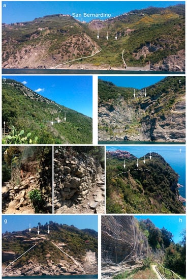
Figure 4.
Main landslides and critical issues recognized along the “Sentiero Verde-Azzurro” trail: (a) Guvano landslide; (b) Macereto area; (c) rock sea cliff equipped with falling rock protections, Crovarla Valley; (d) local dry-stone wall collapse along the path; (e) visible dry-stone wall deformation along the SVA trail between Vernazza and Corniglia; (f) degradation scarp in correspondence of the Guvano beach, close to Corniglia; (g) rockslide close to Vernazza; and (h) local rock falls corresponding to the bedrock outcropping along the “Sentiero Verde-Azzurro” trail. White arrows indicate the path location.
Moving on from Corniglia to Vernazza, the main landslides that intersect the SVA trail are: (i) the Guvano landslide, (ii) the Macereto area, and (iii) the Vernazza rockslide. The Guvano landslide is a complex landslide extending from San Bernardino hamlet (approximately 350 m a.s.l.) to the seaside (Figure 4a). The source area evolves into rock falls and topples, threatening the main road positioned just above the SVA track. This complex landslide then evolved into an earth flow, generating a large accumulation whose toe is exposed to the erosional activity of the sea waves and that in the past was stabilized by different protection measures. This landslide is monitored by a permanent network of GNSS stations and instrumented with five inclinometers derived from a past geotechnical investigation performed in 2003–2004 [32,41].
The Macereto area corresponds to a wide slope sector with widespread rock falls and other geo-hydrological instabilities, mainly due to drainage network failure (Figure 4b). Almost the entire area is equipped with massive rock fall defences and barriers along the path. In the western portion, defined as the “Gerai area”, an important engraved channel threatens the dry-stone wall built upstream of the trail to protect it (Figure 4e). The Vernazza rockslide took place in the upstream portion of the trail, actually equipped by rivets, while the landslide body, made up of large rock blocks, extends up to the shoreline (Figure 4g). Numerous rock falls, degradation scarps and engraved channels associated with debris cones are observed along the entire path, both in the upstream and downstream sectors (Figure 4c,h). The impressive degradation scarps, which are mainly located just downstream of the trail and threaten the road, correspond to the “Prevo area”, a small hamlet between Corniglia and Vernazza, defined as the “Massolina area” on the right side of the Guvano landslide, as well as in correspondence of the Guvano beach area (Figure 4f).
OMs allow a rapid evaluation of the state-of-the-art by providing an overall picture of the geological-geomorphological setting of the study area, identifying the main geo-hydrological instabilities and critical issues that can threaten the trail network.
For each document, a brief form has been reported to identify a distinct phenomenon or critical issue, indicating the general information about the geographic location, type of phenomenon, and state of activity. Then, an analysis of previous data, including scientific papers, technical reports and eventual map annexes, has been carried out, dividing the collected information into three sub-sections: i. photographic evidence, ii. geological and geomorphological settings and iii. available data analysis. Significant importance has been given to the degree of interference between the recognized geo-hydrological instabilities and the SVA trail. By reference to the eleven critical issues recognized and analysed in the OMs, the SVA trail has been divided on the basis of the degree of potential risk, considering high, medium and low interferences between the geo-hydrological instability and the path (Figure 5).
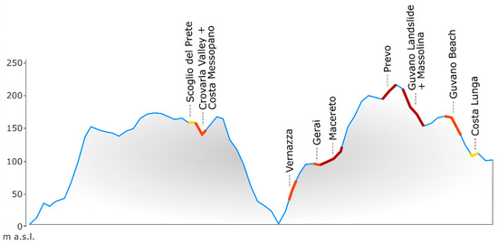
Figure 5.
Sketch of the “Sentiero Verde-Azzurro” trail profile characterized on the basis of the degree of hazard with respect to the recognized geo-hydrological instabilities described in the OMs: high interference in red, medium degree in orange, and low degree in yellow.
OMs have been developed to support “Presidianti” in the recognition of new phenomena and in the identification of possible changes in known phenomena, giving a full description of what we already know. A brief summary, as comprehensive as possible, of the available data is provided. In association, technical and remedial solutions aimed at effective risk management can be proposed.
4.2. Survey Form
The survey sheet has been developed to be used by geologists hired by the National Park in the case of some slope instabilities affecting a trail, or when a severe weather alert leads the Park authority to close the trail network. Under these circumstances, such geologists are in charge of performing a detailed Cinque Terre trail survey to identify potentially dangerous situations or ground effects that could hamper the reopening of the trail.
The survey sheet is composed of two main sections: i. general overview and ii. geo-hydrological phenomena and/or other detected evidence. The first section (Figure 6a) principally includes geographic information, useful for the localization of the documented phenomenon, completed with eventual photos, geological and geomorphological sketch and other eventual annexes. The second section focuses on damages and the occurred process (Figure 6b,c), including: i. damage or processes related to water runoff; ii. damage or processes related to slope instabilities; iii. damage or processes occurring to roads, trail sectors and other infrastructure; iv. eventual problem and description of damage occurring to the National Park signposting; and v. other potential problems. Every recognized phenomenon or damage is scheduled, reporting a brief description, the date of the event (if known), and the hour.
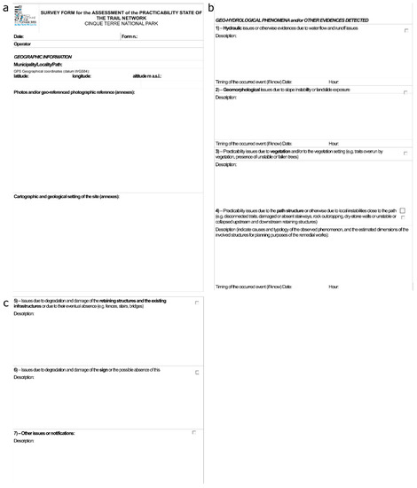
Figure 6.
Survey sheet structure: (a) general overview section, (b,c) geo-hydrological phenomena and/or detected evidence section.
4.3. Codified Procedure for the Identification and Mapping of the Effects of Heavy Rainfall Events
Starting from the experience of past events (e.g., 25 October 2011), when adverse weather conditions obliged the closure of the Cinque Terre National Park trails, we designed a procedure aimed at the identification of possible effects that can reduce the safety of trails.
Through the establishment of a repeatable and effective protocol aimed at a “multi-user” exploitation during the occurrence of an emergency, this procedure addresses the needs of the Cinque Terre National Park for useful geo-hydrological risk management.
Figure 7 shows the structure of the proposed codified procedure. The weather alert follows the meteorological and hydrological forecasting and warning procedures adopted by the Liguria Region [49], based on the 27 February 2004 Directive of the Italian President of the Council of Ministers of “Guidelines for the organizational and functional management of national and regional warning system for hydraulic and geo-hydrological risks for Civil Protection purposes”. At the regional scale, five alert zones defined on the basis of physiographic aspects, both topological (i.e., catchment extent) and meteorological criteria were established by the Italian National Civil Protection Department with respect to the level of hazard in terms of floods and landslides. A total of four alert levels have been defined, following a “traffic-light” code. In a meteorological and hydrological “state of alert” when “orange” or “red” alert levels are being issued, the SVA path closure is planned.
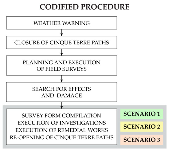
Figure 7.
Codified procedure proposed for the Cinque Terre National Park administration after a weather warning occurrence.
In the path network closure and activation of the “Presidianti” phase, geologists selected within the National Association of Geologists and coming from diverse regions of Italy are designated by the Cinque Terre Park authority to carry out field surveys along the entire SVA trail. Beforehand, the selected “Presidianti” are adequately trained with dedicated formation courses aimed at providing an overall geological and geomorphological knowledge of this characteristic landscape. It should be noted that in this phase, OMs supply the “Presidianti” with a global interpretation and explanation of the state of the art about the geo-hydrological hazards previously recognized along the path.
In the possible effects and damage identification by the “Presidianti” phase, the “Presidianti” carry out the dedicated field survey along the path to identify all the new and/or reactivated geo-hydrological instabilities that occurred after a relevant meteorological event. In the Survey Form compilation process and communication by the “Presidianti” to the Cinque Terre Park phase, SFs supply a pre-defined form to collect and inventory all information on geo-hydrological hazards threatening the path through the compilation of a series of alphanumeric fields. After, the field surveys and SF drafting, the “Presidianti” transmit these documents to the Cinque Terre Park authority.
At the final step of our procedure, i.e., possible remediation activities coordinated by Cinque Terre Park and re-opening of the Network path, specific and dedicated interventions along the trail are predisposed by the Park authority, assisted by external consultants, if necessary, aimed at the re-opening of the path to tourists.
Starting from the path closure up to the SF compilation and transmission to the Park authority, three possible scenarios may occur, on the basis of the level of damage and effects that occurred after the weather alert. Figure 7 shows the first scenario, which arises when no damage or effects occur. After the “Presidianti” involvement by the Park authority, the field survey supported by the OMs is planned. Scenario 1 (Figure 8) is applied when no difference with respect to the previous setting takes place, and any new or reactivated geo-hydrological instabilities occur. In this scenario, the “Presidianti” state the absence of critical issues to the Cinque Terre Park administrators, hence the absence of SF drafting, by concluding their survey.
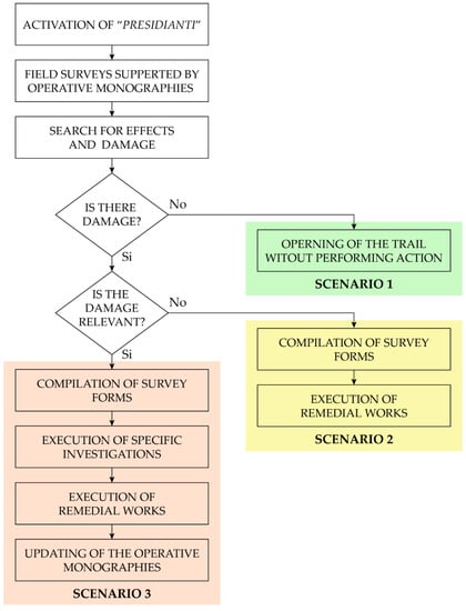
Figure 8.
Structure of the codified procedure for different Scenarios.
Scenario 2 (Figure 8) is planned in cases of limited damage, and effects are observed during field surveys. For instance, a minor damage condition can be represented, for example, by trees falling down or by small stones located along the path (Figure 9a–c). In those cases, an SF is filled in for each critical issue observed. Subsequently, all the compiled SFs are transferred to the Cinque Terre Park authority and commensurate remedial works are planned and executed before the reopening of the trail.
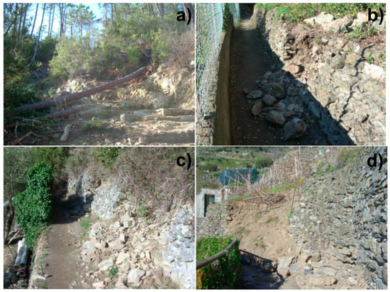
Figure 9.
Examples of damage and/or rainfall-induced effects recorded using survey forms after a weather alert: (a) trees fall down; (b,c) small dry-stone wall collapses; and (d) dry-stone wall failure causing a local path interruption.
Scenario 3 (Figure 8) considers the possibility that the meteorological event could cause relevant damage. Rainfall-induced landslides, runoff and erosion processes are the most common effects that could occur. In this case, the “Presidiante” fills in an SF for each geo-hydrological instability identified, considering both first activated or re-activated instabilities, that partially or totally involve the surface path. A focus has also been dedicated to local damage to the dry-stone walls that could collapse involving the path surface (Figure 9d). Even in this case, the first identification of the critical condition is based on the completion of the SFs and a consequent report to the Cinque Terre Park authority that will activate the procedure for the implementation of remedial works. It should be noted that if the geo-hydrological phenomenon, already described in the OM in this area, is reactivated during the most recent meteorological event, at the end of the procedure, the update of the dedicated OM is mandatory to guarantee a correct description of known geo-hydrological instabilities. Moreover, if a new and relevant geo-hydrological phenomenon has been identified during the dedicated field survey, a new OM can be drafted to constantly update a standardized document and the overall state-of-the art of the study area.
5. Discussion and Conclusions
The increased awareness of local and national administrators in preventing damage to geological and cultural heritage is constantly growing. Planning for the assessment of both pre-existing and future effects of geo-hydrological instabilities becomes an essential aspect for managing popular tourist landscapes and therefore, limiting further degradation, ensuring long-term sustainability, and assuring the safety of conditions along trails.
The sites of geological and cultural interest, in both nature conservation and tourist sectors, are often threatened by geo-hydrological hazards, which could put the accessibility of the heritage sites themselves in danger [50]. Similarly, the local agricultural policies on the rural landscape, with consequent abandonment in farming, may lead to an increase in slope instabilities [51,52,53,54,55]. Some efforts have been made to highlight that the knowledge of past and current geological and geomorphological processes can help to increase the awareness and perception of geo-hydrological risks [43,56,57,58]. In Italy, slope instabilities threaten 25% of the UNESCO sites, flooding threatens 54% of the sites and earthquakes threaten 82% [59].
A proper assessment of the potential geo-hydrological hazards and possible damage to geological and cultural heritage sites is the key element for effective risk management and prevention. In fact, the availability of specific procedures able to provide management strategies to preserve these unique landscapes and based on the interoperability of geoscientists, practitioners and cultural heritage managers are limited or missing.
In this work, we proposed a new codified procedure for the management of the “Sentiero Verde-Azzurro” trail, one of the main popular paths of the Cinque Terre National Park. This UNESCO site is historically closely linked to the anthropic modification of the environment, mainly represented by agricultural terraces bounded by dry-stone walls. Agricultural terraces record at least one thousand years of human fingerprint necessary to modify and adapt a natural and tough environment for cultivation purposes. This unique site, visited by people from all over the world, shows a complex equilibrium between the geomorphological environment fully integrated with human interventions, and the usability of the path network by hundreds of thousands of tourists every year. The combination of gravity and runoff processes, characterizing the steep slopes of the terraced coastal basins, coupled with marine erosion along the coastline, promotes the occurrence of geo-hydrological instabilities, especially in the case of heavy rainfall events. In addition, the effects of such geohazards are favoured by the extensive abandonment of the agricultural terraces.
A procedure aimed at addressing the needs of the Cinque Terre National Park for useful geo-hydrological risk management was implemented. The main goal was to establish a repeatable and effective procedure to be applied after relevant meteorological events affecting the Park territory. This requirement was born from previous experiences [34] in which we realized that the lack of a standard way to collect and organize data and information about geo-hydrological phenomena and related damage could be a crucial problem in landslide risk assessment and management. For several years, the use of defined methodologies and specific protocols has been considered quite usual and well-established in some specific fields for emergency management [60,61]. For example, for the International Civil Aviation Organization (ICAO), in the medical framework or in industrial risk management, the adoption of standard protocols is mandatory to define the specific actions that competent institutions and stakeholders should execute. This led us to find a proper solution in geo-hydrological risk management in this unique landscape through the definition of a predefined protocol to adopt in the case of severe meteorological events. However, it is important to note that, with respect to, for example, an industrial accident, in the case of geo-hydrological risk, this codification is difficult to achieve due to the high variability in data and involved entities. Diverse scenarios could take place, mainly on the basis of typology and the characteristics of the occurred phenomena and related damage. This large range of possibilities overcomplicates the drafting of the procedure. Therefore, we defined a methodology that is based on two instruments (the OMs and the SFs) and on the definition of three possible scenarios.
Based on the available information and experiences gained during previous adverse meteorological events, a codified methodology was proposed. The foreground has been primarily acquired by investigating the effects of severe floods in recent years in the Liguria Region, among which is the flood of 2011 [3,21,24], and considering other events such as those in November 2014 [17,21], and November 2016 [22]. This procedure is aimed at developing an approach that is standardized as much as possible for field survey operations to be carried out after relevant rainstorms and is useful for “multi-user” exploitation during the occurrence of emergencies.
The importance of the correct management of the impact of slope instabilities on Cinque Terre trails is particularly evident in Raso et al. [8], who made an inventory of landslides that have an interaction with trails. Starting from this published inventory, it is possible to identify that 66 landslides have a direct impact on the trails. In particular, from the methodological point of view, we focused on a stretch of the SVA trail (1.1 km on a total length of the 149 km trail network in the entire park) that is the most visited path by tourists and one of the most affected by slope instabilities of different typologies.
The overall geo-hydrological instabilities interacting with the SVA trail have been identified and analysed using OMs. This standardized procedure represents a useful tool for obtaining a focus on the main geo-hydrological instabilities affecting the area of interest and their degree of impact on the usability of the path. The OMs also constitute a useful tool for the “Presidianti”, the first actors in the implemented procedure activated upon the occurrence of severe meteorological events. It should be noted that these expert geologists are selected at a national level and potentially do not have a specific awareness of the investigated area of interest, which can be filled using the OMs.
The combined use of OMs and SFs by the “Presidianti” guarantees constant updating on the potential interferences between the identified geo-hydrological instabilities and the SVA trail. Moreover, the SF data structure has been implemented to allow a simple and functional construction composed of cartographic information and alphanumeric fields so that it can be easily converted into a digital data management system for completion. In this context, the proposed methodology represents, from now, an easy instrument to make comparative analysis over the time of all the produced documents by any “Presidiante”, thanks to their standard structure, and make an overall evaluation of the geo-hydrological phenomena effects on the Cinque Terre National Park.
The codified process may constitute the basis for an extended analysis of the interaction between landslides and the entire hiking network of the National Park. Therefore, the standardised procedure should provide a practical response to the needs for the National Park authority to enhance a sustainable administration of the territory and schedule the appropriate management measures, to guarantee the safeguard of both heritage and tourists safety from geo-hydrological risks. Our strategy allows the effective management of geo-hydrological risks in a highly geological and cultural heritage site, where the high influx of tourists and human pressure require a well-defined procedure, especially with the occurrence of weather alerts. The implemented methodology constitutes a useful approach for a sustainable use of the territory, which is also applicable in similar UNESCO sites.
Author Contributions
Conceptualization, D.G. (Daniele Giordan); methodology, D.G. (Daniele Giordan), M.C., and D.G. (Danilo Godone); software, D.G. (Danilo Godone); validation, D.C., A.C., and M.F.; investigation, D.G. (Daniele Giordan), M.C., D.G. (Danilo Godone), G.P., and E.R.; data curation, M.C., D.G. (Danilo Godone), and S.P.; writing—original draft preparation, M.C., D.G. (Danilo Godone), D.G. (Daniele Giordan), and G.P.; writing—review and editing, D.C., A.C., M.F., and S.P.; visualization, M.C., D.G. (Danilo Godone), G.P., and S.P.; supervision, P.S.; project administration, S.P., and M.G.; funding acquisition, M.G. All authors have read and agreed to the published version of the manuscript.
Funding
This research was partially funded by “Paesaggi sicuri: strategie di prevenzione e adattamento” project (http://www.irpi.cnr.it/project/paesaggi-sicuri/), promoted by the Ministry of Cultural Heritage and Activities and Tourism (MiBACT)–Segretariato Regionale per la Liguria, on a financing L77/2006, Special Measures of protection and use in favor of the UNESCO Sites and Elements.
Acknowledgments
The authors acknowledge Surveyor Lorena Pasini of the Cinque Terre National Park that kindly allowed the waterboard survey.
Conflicts of Interest
The authors declare no conflict of interest.
References
- Canuti, P.; Casagli, N.; Pellegrini, M.; Tosatti, G. Geo-hydrological hazards. In Anatomy of an Orogen: The Apennines and Adjacent Mediterranean Basins; Springer: Dordrecht, The Netherlands, 2001; pp. 513–532. [Google Scholar]
- Guzzetti, F.; Stark, C.P.; Salvati, P. Evaluation of Flood and Landslide Risk to the Population of Italy. Environ. Manag. 2005, 36, 15–36. [Google Scholar] [CrossRef] [PubMed]
- Cevasco, A.; Brandolini, P.; Scopesi, C.; Rellini, I. Relationships between geo-hydrological processes induced by heavy rainfall and land-use: The case of 25 October 2011 in the Vernazza catchment (Cinque Terre, NW, Italy). J. Maps 2013, 9, 289–298. [Google Scholar]
- Newsome, D.; Dowling, R.; Leung, Y.F. The nature and management of geotourism: A case study of two established iconic geotourism destinations. Tour. Manag. Perspect. 2012, 2–3, 19–27. [Google Scholar] [CrossRef]
- Dong, H.; Song, Y.; Chen, T.; Zhao, J.; Yu, L. Geoconservation and geotourism in Luochuan Loess National Geopark, China. Quat. Int. 2014, 334–335, 40–51. [Google Scholar] [CrossRef]
- Ferrero, E.; Magagna, A. Natural hazards and geological heritage in earth science education projects. Geol. Soc. Lond. Spec. Publ. 2015, 419, 149–160. [Google Scholar] [CrossRef]
- Cevasco, A.; Diodato, N.; Revellino, P.; Fiorillo, F.; Grelle, G.; Guadagno, F.M. Storminess and geo-hydrological events affecting small coastal basins in a terraced Mediterranean environment. Sci. Total Environ. 2015, 532, 208–219. [Google Scholar] [CrossRef]
- Raso, E.; Cevasco, A.; Di Martire, D.; Pepe, G.; Scarpellini, P.; Calcaterra, D.; Firpo, M. Landslide-inventory of the Cinque Terre National Park (Italy) and quantitative interaction with the trail network. J. Maps 2019, 15, 818–830. [Google Scholar] [CrossRef]
- UNESCO. Unesco List. Available online: http://whc.unesco.org/en/list/826 (accessed on 11 March 2019).
- UNESCO. Intangible Cultura Heritage UNESCO. Available online: https://ich.unesco.org/en/RL/art-of-dry-stone-walling-knowledge-and-techniques-01393#identification (accessed on 11 March 2019).
- Terranova, R. Aspetti geomorfologici e geologico-ambientali delle Cinque Terre: Rapporti con le opere umane (Liguria orientale). Stud. Ric. Geogr. 1989, 12, 1–58. [Google Scholar]
- Terranova, R.; Brandolini, P.; Spotorno, M.; Rota, M.P.; Montanari, C.; Galassi, D.; Nicchia, P.; Leale, S.; Bruzzo, R.; Renzi, L.; et al. Patrimoni de marjades a la Mediterrania Occidental. Una proposta de catalogaciò; Commissione Europea DGX, Programma Raphael: Palma di Malorca, Spain, 2002. [Google Scholar]
- Canuti, P.; Casagli, N.; Ermini, L.; Fanti, R.; Farina, P. Landslide activity as a geoindicator in Italy: Significance and new perspectives from remote sensing. Environ. Geol. 2004, 45, 907–919. [Google Scholar] [CrossRef]
- Brandolini, P.; Pepe, G.; Capolongo, D.; Cappadonia, C.; Cevasco, A.; Conoscenti, C.; Marsico, A.; Vergari, F.; Del Monte, M. Hillslope degradation in representative Italian areas: Just soil erosion risk or opportunity for development? Land Degrad. Dev. 2018, 29, 3050–3068. [Google Scholar] [CrossRef]
- Cevasco, A.; Pepe, G.; Brandolini, P. The influences of geological and land use settings on shallow landslides triggered by an intense rainfall event in a coastal terraced environment. Bull. Eng. Geol. Environ. 2014, 73, 859–875. [Google Scholar] [CrossRef]
- Cevasco, A.; Pepe, G.; D’Amato Avanzi, G.; Giannecchini, R. A study on the 10 November 2014 intense rainfall and the related landslides in the lower Lavagna valley (eastern Liguria). Rend. Online Soc. Geol. Ital. 2015, 35, 66–69. [Google Scholar] [CrossRef]
- Giordan, D.; Cignetti, M.; Baldo, M.; Godone, D. Relationship between man-made environment and slope stability: The case of 2014 rainfall events in the terraced landscape of the Liguria region (northwestern Italy). Geomat. Nat. Hazards Risk 2017, 8, 1833–1852. [Google Scholar] [CrossRef]
- Godone, D.; Giordan, D.; Baldo, M. Rapid mapping application of vegetated terraces based on high resolution airborne lidar. Geomat. Nat. Hazards Risk 2018, 9, 970–985. [Google Scholar] [CrossRef]
- Cignetti, M.; Godone, D.; Giordan, D. Shallow landslide susceptibility map of the Rupinaro catchment, Liguria (northwestern Italy). J. Maps 2019, 15, 333–345. [Google Scholar] [CrossRef]
- Guzzetti, F.; Cardinali, M.; Reichenbach, P.; Cipolla, F.; Sebastiani, C.; Galli, M.; Salvati, P. Landslides triggered by the 23 November 2000 rainfall event in the Imperia Province, Western Liguria, Italy. Eng. Geol. 2004, 73, 229–245. [Google Scholar] [CrossRef]
- Cevasco, A.; Pepe, G.; D’Amato Avanzi, G.; Giannecchini, R. Preliminary analysis of the November 10, 2014 rainstorm and related landslides in the lower Lavagna Valley (Eastern Liguria). Ital. J. Eng. Geol. Environ. 2017, 1, 5–15. [Google Scholar]
- Pepe, G.; Mandarino, A.; Raso, E.; Cevasco, A.; Firpo, M.; Casagli, N. Extreme Flood and Landslides Triggered in the Arroscia Valley (Liguria Region, Northwestern Italy) During the November 2016 Rainfall Event. In Proceedings of the IAEG/AEG Annual Meeting Proceedings, San Francisco, CA, USA, 17–21 September 2018; Springer: Cham, Switzerland, 2019; Volume 1, pp. 171–175. [Google Scholar]
- Faccini, F.; Luino, F.; Sacchini, A.; Turconi, L.; De Graff, J.V. Geohydrological hazards and urban development in the Mediterranean area: An example from Genoa (Liguria, Italy). Nat. Hazards Earth Syst. Sci. 2015, 15, 2631–2652. [Google Scholar] [CrossRef]
- Cevasco, A.; Pepe, G.; Brandolini, P. Shallow landslides induced by heavy rainfall on terraced slopes: The case study of the October, 25, 2011 event in the Vernazza catchment (Cinque Terre, NW Italy). Rend. Online Soc. Geol. Ital. 2012, 21, 384–386. [Google Scholar]
- Brandolini, P.; Cevasco, A.; Capolongo, D.; Pepe, G.; Lovergine, F.; Del Monte, M. Response of Terraced Slopes to a Very Intense Rainfall Event and Relationships with Land Abandonment: A Case Study from Cinque Terre (Italy). Land Degrad. Dev. 2018, 29, 630–642. [Google Scholar] [CrossRef]
- Pepe, G.; Mandarino, A.; Raso, E.; Scarpellini, P.; Brandolini, P.; Cevasco, A. Investigation on Farmland Abandonment of Terraced Slopes Using Multitemporal Data Sources Comparison and Its Implication on Hydro-Geomorphological Processes. Water 2019, 11, 1552. [Google Scholar] [CrossRef]
- Schilirò, L.; Cevasco, A.; Esposito, C.; Mugnozza, G.S. Shallow landslide initiation on terraced slopes: Inferences from a physically based approach. Geomat. Nat. Hazards Risk 2018, 9, 295–324. [Google Scholar] [CrossRef]
- Zingaro, M.; Refice, A.; Giachetta, E.; D’Addabbo, A.; Lovergine, F.; De Pasquale, V.; Pepe, G.; Brandolini, P.; Cevasco, A.; Capolongo, D. Sediment mobility and connectivity in a catchment: A new mapping approach. Sci. Total Environ. 2019, 672, 763–775. [Google Scholar] [CrossRef] [PubMed]
- Park, C.T.N. Cinque Terre National Park. Available online: http://www.parconazionale5terre.it/ (accessed on 11 March 2019).
- Raso, E.; Mandarino, A.; Pepe, G.; Di Martire, D.; Cevasco, A.; Calcaterra, D.; Firpo, M. Landslide Inventory of the Cinque Terre National Park, Italy. In Proceedings of the IAEG/AEG Annual Meeting Proceedings, San Francisco, CA, USA, 17–21 September 2018; Springer: Cham, Switzerland, 2019; Volume 1, pp. 201–205. [Google Scholar]
- Brandolini, P. The Outstanding Terraced Landscape of the Cinque Terre Coastal Slopes (Eastern Liguria). In Landscapes and Landforms of Italy; Springer: Cham, Switzerland, 2017; pp. 235–244. [Google Scholar]
- Raso, E.; Brandolini, P.; Faccini, F.; Firpo, M. The Guvano complex landslide in the Cinque Terre National Park, Italy: Geomorphological characterization, GNSS monitoring and risk management. In Proceedings of the ISRM International Symposium-EUROCK 2016, Ürgüp, Turkey, 29–31 August 2016. [Google Scholar]
- Galve, J.P.; Cevasco, A.; Brandolini, P.; Soldati, M. Assessment of shallow landslide risk mitigation measures based on land use planning through probabilistic modelling. Landslides 2015, 12, 101–114. [Google Scholar] [CrossRef]
- Giordan, D.; Cignetti, M.; Wrzesniak, A.; Allasia, P.; Bertolo, D. Operative Monographies: Development of a New Tool for the Effective Management of Landslide Risks. Geosciences 2018, 8, 485. [Google Scholar] [CrossRef]
- Federici, P.R.; Baldacci, F.; Petresi, A.; Serani, A. Atlante dei Centri Abitati Instabili della Liguria. I Provincia della Spezia; Università degli Studi di Pisa: Genova, Italy, 2001. [Google Scholar]
- De Stefanis, A.; Martini, M.; Terranova, R.; De Luigi, G. I Movimenti Franosi di Guvano e di Rodalabia Nelle Cinque Terre e i Loro Riflessi Sulla Morfologia Della Costa Ligure e Sugli Insediamenti; Mem. Soc. Geol. Ital.: Roma, Italy, 1978. [Google Scholar]
- Cevasco, A.; Pepe, G.; Brandolini, P. Geotechnical and stratigraphic aspects of shallow landslides at Cinque Terre (Liguria, Italy). Rend. Online Soc. Geol. Ital. 2013, 24, 52–54. [Google Scholar]
- Abbate, E. Geologia Delle Cinque Terre e Dell’entroterra di Levanto (Liguria Orientale); Arti grafiche Pacini Mariotti: Pisa, Italy, 1969. [Google Scholar]
- Gianmarino, S.; Giglia, G. Gli elementi strutturali della piega di La Spezia nel contesto geodinamico dell’Appennino settentrionale. Boll. Soc. Geol. Ital. 1990, 109, 683–692. [Google Scholar]
- Liguria Region. Geoportal Liguria Region. Available online: https://geoportal.regione.liguria.it/ (accessed on 12 September 2019).
- Raso, E.; Brandolini, P.; Faccini, F.; Realini, E.; Caldera, S.; Firpo, M. Geomorphological evolution and monitoring of San Bernardino-Guvano coastale landslide (Eastern Liguria, Italy). Geogr. Fis. Din. Quat. 2017, 40, 197–210. [Google Scholar]
- ISPRA Ambiente. IFFI Catalogue. Available online: http://www.isprambiente.gov.it/it/progetti/suolo-e-territorio-1/iffi-inventario-dei-fenomeni-franosi-in-italia (accessed on 12 September 2019).
- Lollino, G.; Audisio, C. UNESCO World Heritage sites in Italy affected by geological problems, specifically landslide and flood hazard. Landslides 2006, 3, 311–321. [Google Scholar] [CrossRef]
- Avanzi, G.D.; Galanti, Y.; Giannecchini, R.; Bartelletti, C. Shallow landslides triggered by the 25 October 2011 extreme rainfall in Eastern Liguria (Italy). In Engineering Geology for Society and Territory—Volume 2: Landslide Processes; Springer: Cham, Switzerland, 2015; pp. 515–519. ISBN 9783319090573. [Google Scholar]
- Rinaldi, M.; Amponsah, W.; Benvenuti, M.; Borga, M.; Comiti, F.; Lucía, A.; Marchi, L.; Nardi, L.; Righini, M.; Surian, N. An integrated approach for investigating geomorphic response to extreme events: Methodological framework and application to the October 2011 flood in the Magra River catchment, Italy. Earth Surf. Process. Landf. 2016, 41, 835–846. [Google Scholar] [CrossRef]
- Brunetti, M.; Bertolini, A.; Soldati, M.; Maugeri, M. High-resolution analysis of 1-day extreme precipitation in a wet area centered over eastern Liguria, Italy. Theor. Appl. Climatol. 2019, 135, 341–353. [Google Scholar] [CrossRef]
- Galanti, Y.; Barsanti, M.; Cevasco, A.; D’Amato Avanzi, G.; Giannecchini, R. Comparison of statistical methods and multi-time validation for the determination of the shallow landslide rainfall thresholds. Landslides 2018, 15, 937–952. [Google Scholar] [CrossRef]
- Brandolini, P.; Cevasco, A. Geo-hydrological Risk Mitigation Measures and Land-Management in a Highly Vulnerable Small Coastal Catchment. In Engineering Geology for Society and Territor; Springer: Cham, Switzerland, 2015; Volume 5, pp. 759–762. [Google Scholar]
- Allerta Liguria. Available online: http://www.allertaliguria.gov.it/ (accessed on 18 Mar 2019).
- Reynard, E.; Perret, A.; Bussard, J.; Grangier, L.; Martin, S. Integrated Approach for the Inventory and Management of Geomorphological Heritage at the Regional Scale. Geoheritage 2016, 8, 43–60. [Google Scholar] [CrossRef]
- Godone, D.; Garbarino, M.; Sibona, E.; Garnero, G.; Godone, F. Progressive fragmentation of a traditional Mediterranean landscape by hazelnut plantations: The impact of CAP over time in the Langhe region (NW Italy). Land Use Policy 2014, 36, 259–266. [Google Scholar] [CrossRef]
- Koulouri, M.; Giourga, C. Land abandonment and slope gradient as key factors of soil erosion in Mediterranean terraced lands. CATENA 2007, 69, 274–281. [Google Scholar] [CrossRef]
- García-Ruiz, J.M.; Lana-Renault, N. Hydrological and erosive consequences of farmland abandonment in Europe, with special reference to the Mediterranean region—A review. Agric. Ecosyst. Environ. 2011, 140, 317–338. [Google Scholar] [CrossRef]
- Moreno-de-las-Heras, M.; Lindenberger, F.; Latron, J.; Lana-Renault, N.; Llorens, P.; Arnáez, J.; Romero-Díaz, A.; Gallart, F. Hydro-geomorphological consequences of the abandonment of agricultural terraces in the Mediterranean region: Key controlling factors and landscape stability patterns. Geomorphology 2019, 333, 73–91. [Google Scholar] [CrossRef]
- Tarolli, P.; Preti, F.; Romano, N. Terraced landscapes: From an old best practice to a potential hazard for soil degradation due to land abandonment. Anthropocene 2014, 6, 10–25. [Google Scholar] [CrossRef]
- Howard, A.J. Managing global heritage in the face of future climate change: The importance of understanding geological and geomorphological processes and hazards. Int. J. Herit. Stud. 2013, 19, 632–658. [Google Scholar] [CrossRef]
- Agapiou, A.; Lysandrou, V.; Alexakis, D.D.; Themistocleous, K.; Cuca, B.; Argyriou, A.; Sarris, A.; Hadjimitsis, D.G. Cultural heritage management and monitoring using remote sensing data and GIS: The case study of Paphos area, Cyprus. Comput. Environ. Urban Syst. 2015, 54, 230–239. [Google Scholar] [CrossRef]
- Reimann, L.; Vafeidis, A.T.; Brown, S.; Hinkel, J.; Tol, R.S.J. Mediterranean UNESCO World Heritage at risk from coastal flooding and erosion due to sea-level rise. Nat. Commun. 2018, 9, 4161. [Google Scholar] [CrossRef]
- Canuti, P.; Margottini, C.; Fanti, R.; Bromhead, E.N. Cultural Heritage and Landslides: Research for Risk Prevention and Conservation. In Landslides—Disaster Risk Reduction; Springer: Berlin/Heidelberg, Germany, 2009; pp. 401–433. [Google Scholar]
- Caragliano, S.; Manca, D. Emergency Management and Land Use Planning in Industrial Hazardous Areas: Learning from an Italian Experience. J. Contingencies Cris. Manag. 2007, 15, 194–207. [Google Scholar] [CrossRef]
- Campedel, M.; Cozzani, V.; Garcia-Agreda, A.; Salzano, E. Extending the Quantitative Assessment of Industrial Risks to Earthquake Effects. Risk Anal. 2008, 28, 1231–1246. [Google Scholar] [CrossRef]
© 2020 by the authors. Licensee MDPI, Basel, Switzerland. This article is an open access article distributed under the terms and conditions of the Creative Commons Attribution (CC BY) license (http://creativecommons.org/licenses/by/4.0/).