Review

Built Heritage, Sustainable Development, and Natural Hazards: Flood Protection and UNESCO World Heritage Site Protection Strategies in Krakow, Poland

1
Faculty of Architecture, Cracow University of Technology, 31-155 Kraków, Poland
2
Faculty of Environmental Engineering, Cracow University of Technology, 31-155 Kraków, Poland
3
Department of Architecture, Design and Urban Planning, University of Sassari, 07100 Sassari, Italy
*
Author to whom correspondence should be addressed.
Sustainability 2019, 11(18), 4886; https://doi.org/10.3390/su11184886
Submission received: 30 June 2019 / Revised: 19 August 2019 / Accepted: 25 August 2019 / Published: 6 September 2019
(This article belongs to the Special Issue Built Heritage and Sustainability)

Abstract

:
The protection of larger built-up areas that constitute sections of actively functioning urban zones is a challenge, even under favourable political and economic conditions. The case of Krakow’s historical town centre, which is protected as a historical site by national law and it was placed on the UNESCO World Heritage Sites List in 1978, clearly demonstrates how difficult it is to reconcile the passive character of current conservation doctrines with the demands of the free market and growth-oriented economy, when developer pressure is not sufficiently balanced out by public opinion and urban activist movements, when planning tools are incomplete or insufficient, and the criteria according to which strategic decisions are made are of a quantitative rather than a qualitative character. Apart from commonly encountered problems that are associated with the gentrification of town centres or the negative impact of mass tourism, Krakow must also face a growing flood hazard that stems from its specific and unfavourable hydrological and hydrogeological conditions that are compounded by the uncontrolled and uncoordinated expansion of urbanised areas, the decay of the natural environment, and the consequences of climate change. This article presents the multi-aspect site-specific conditions of the historical centre of Krakow, as well as the analysis of its protection as a UNESCO World Heritage Site, in the context of flood protection, while taking into consideration the environmental, economic, and social dimension of heritage. The critical conclusions that are featured in the work indicate both areas of possible immediate remedial action and the potential directions that new integrated protection strategies would take.

1. Introduction

When civilisation development and climate change combine, they bring along an increase in water-related risks. In the case of cities and urban areas, these are, in particular, an increased risk of the occurrence and the severity of water-related events: torrential rains, flooding caused by inappropriate infrastructure, urban flooding, river flooding, pluvial flooding, high soil dampness, and a shallow groundwater table [1,2,3,4,5,6,7,8]. Previously used strategies that are based on technical solutions are becoming ineffective and increasingly costly, and the lack of a reaction to the coming change will result in an even greater part of the population coming under threat, as well as greater flood-related losses [9]. The Thames Barrier, which protects London against tidal and fluvial foods, built in the years 1974–1984, was used two times per year during the twentieth century, while in the years 2000–2018 it was used more than six times per year [10]. Substantial evidence indicates that the Thames Barrier can become insufficient to protect global heritage sites, like the Westminster Palace or the Tower of London, against a thousand-year flood in as early as 2025 [3]. In the Netherlands, in turn, almost a quarter of the entire country is located on depressed land, whose protection if not its very existence is ensured by embankments and pump systems that drain excess water from overtopping [11,12,13]. At present, around 1.3 billion euro is spent yearly on maintaining this infrastructure, while rising sea levels will require additional investment and increasing maintenance costs, if not a complete overhaul of the protection paradigm [13].
The decreasing effectiveness of technical solutions that arises from increasing risk (climate change, changes in development, rising property prices) caused a change in the philosophy of “protection against water” to one of “living with water” [13,14,15,16]. The European Commission, in the document entitled Towards Better Environmental Options for Flood Risk Management, recommends that: “Flood risk management should work with nature, rather than against it” [17]. The concept of nature-based solutions to lower flood risk by expanding flood areas, old riverbeds, and swamps or returning them to nature, as well as the establishment of green and blue-green urban infrastructure, which, among other things, reduces surface runoff, is currently used more frequently [11,13,14,15,16,18,19,20,21,22].
In European Union (EU) Member States, the basic principles of flood risk management are regulated by the Floods Directive (2007/60/EC) [23]. The original provisions of the directive and the latest recommendations concerning amendments to its interpretation and implementation [24,25] both do not refer to the protection of cultural heritage in detail. The directive defines flood risk as a combination of the probability of flooding and its impact on people, environment, cultural heritage, and economy. Member states identify areas under threat and cultural heritage sites in their planning documents. However, during the first planning cycles, for instance, only 13 Member States reported potential adverse consequences to cultural heritage; seven others have also included cultural heritage features on their national maps [25].
Member States document cultural heritage on risk maps in different ways. There are maps on which cultural heritage is only generally marked, while in some countries certain types of cultural assets are distinguished, such as archaeological digs, buildings, museums, religious sites, landscapes, and other types of cultural heritage [25]. Approaches that include cultural heritage protection in flood risk management strategies are prepared for the local scale (Seville in Spain [4], Genoa in Italy [26], the Sucevita River basin in Romania [27], Taiwan [28], or Aytthaya in Thailand [2]); however, both Polish and European recommendations concerning risk assessment and flood risk management do not provide explicit, clear guidelines in this regard.

2. Materials and Methods

This article is a critical review of the flood risk management solutions that have been employed in Poland in the context of protecting heritage areas, presented in the example of the Old Town complex in Krakow, which was placed on the UNESCO World Heritage Sites List in 1978, and it is protected under national law. This makes it possible to demonstrate the complex relationship between historical, economic, and environmental values of heritage areas that constitute a part of the living and functioning organism of the city and their role in the face of growing environmental threats.
The aim of the study was to answer the following research questions:
  • determine whether, and if and to what degree do current heritage site protection and flood protection strategies complement each other in the case of Krakow; and,
  • what is the current relationship between the city’s heritage area and its hydrographic situation, what was it like in the past, and how it may change in the future.
  • What are the existing and potential impacts of additional factors that shape the city’s development and functioning policy (demography, mass tourism, economy, other environmental hazards, etc.) on adaptability, vulnerability, and resilience of the built heritage area in the context of flood hazard.
  • What is the role that a built heritage area can and should play in development and flood protection strategies while considering the future challenges that the city will face.
In the research strategy applied here, the built heritage area was analysed from a systemic perspective and it was treated as a living element of the city’s tissue, instead of being seen as a historically isolated creation. This approach made it possible to include a scenario, in which built heritage is both the subject and object of protection strategies. It also emphasises the need for using both qualitative and quantitative criteria in the formulation of flood protection strategies and actions instead of being limited exclusively to quantitative ones.
A holistic research strategy combines interdisciplinary thematic studies on various sectors as well as a variety of materials. Meta analysis was hierarchically applied to the following subjects:
  • Structural, spatial, and hydrographic conditions of the city and the resulting hazards presented against a briefly outlined historical background.
  • Current built heritage protection strategies and flood protection strategies, in their legal and formal context, ranging from local solutions (resolutions, strategies, spatial development studies, spatial development plans, spatial risk mitigation plans, etc.), to national legal standards (acts of law, ordinances), EU legal standards (EU resolutions), and international law (conventions).
  • Additional factors that are responsible for the vulnerability of this layout, e.g. the negative demographic phenomena associated with the mass tourism model that occur in the UNESO World Heritage Site area, as well as the rapid and uncontrolled urbanisation of the peripheral areas.
  • The constraints of the current tools and methods as well as the criteria of their evaluation and application among which the very definition of the limits of the area that should be subjected to protection strategies.

3. Results

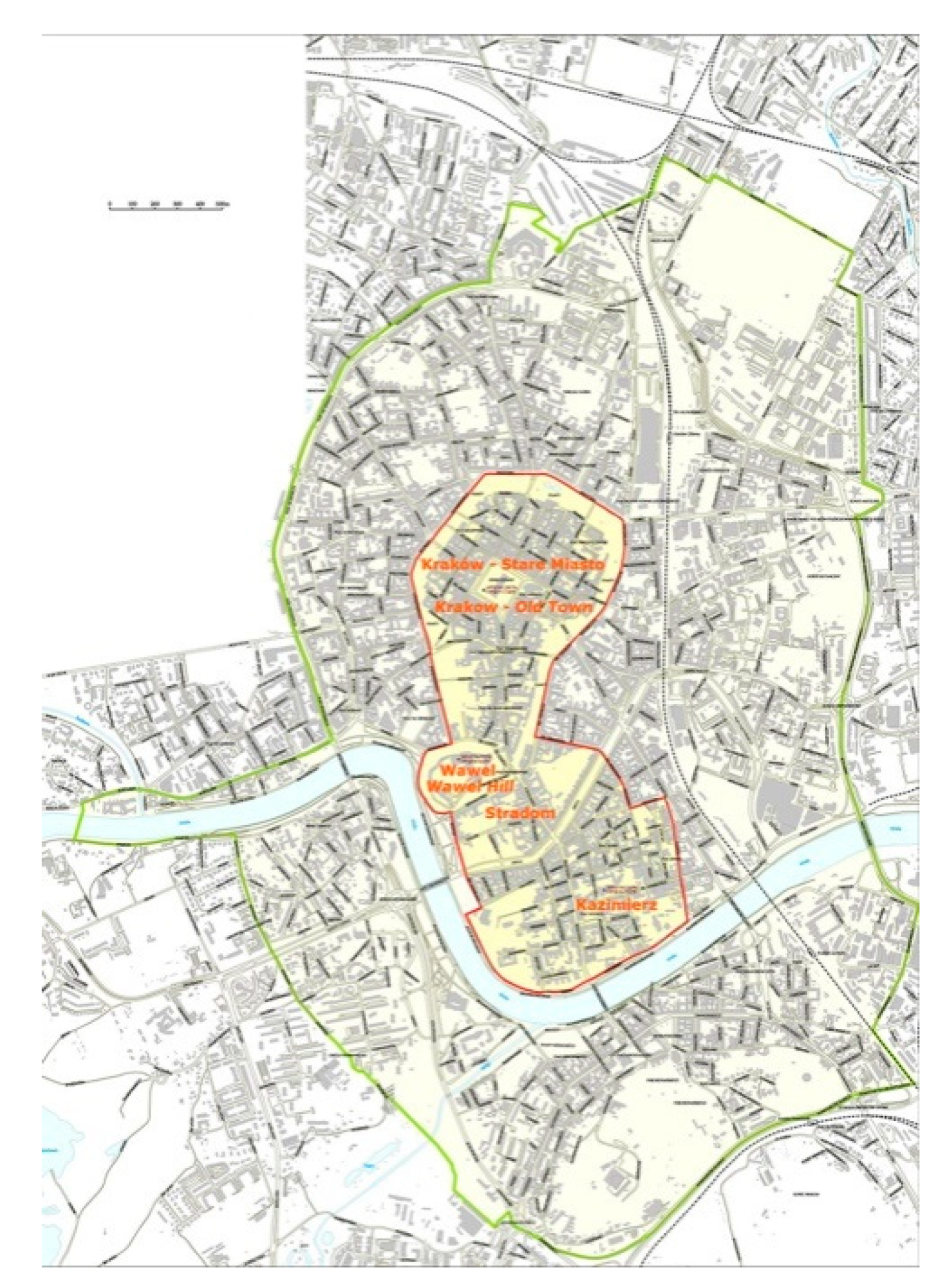
3.1. Krakow—A Monument to History and a UNESCO World Heritage Site of Universal Values

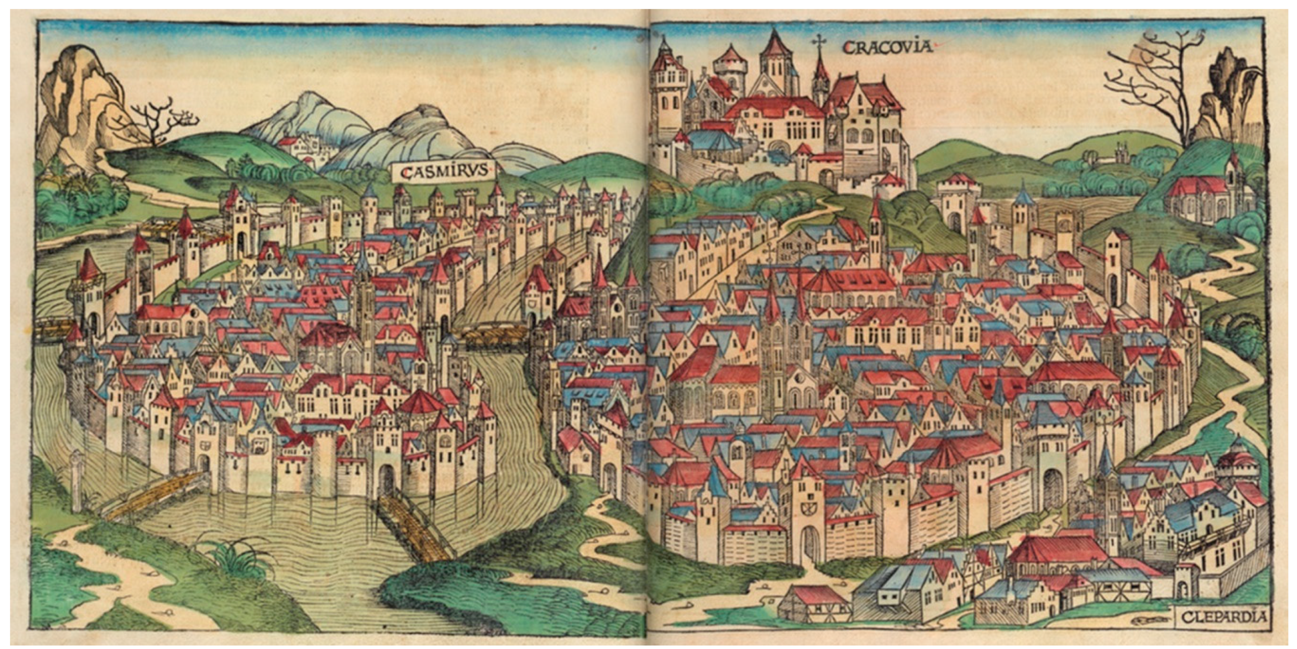
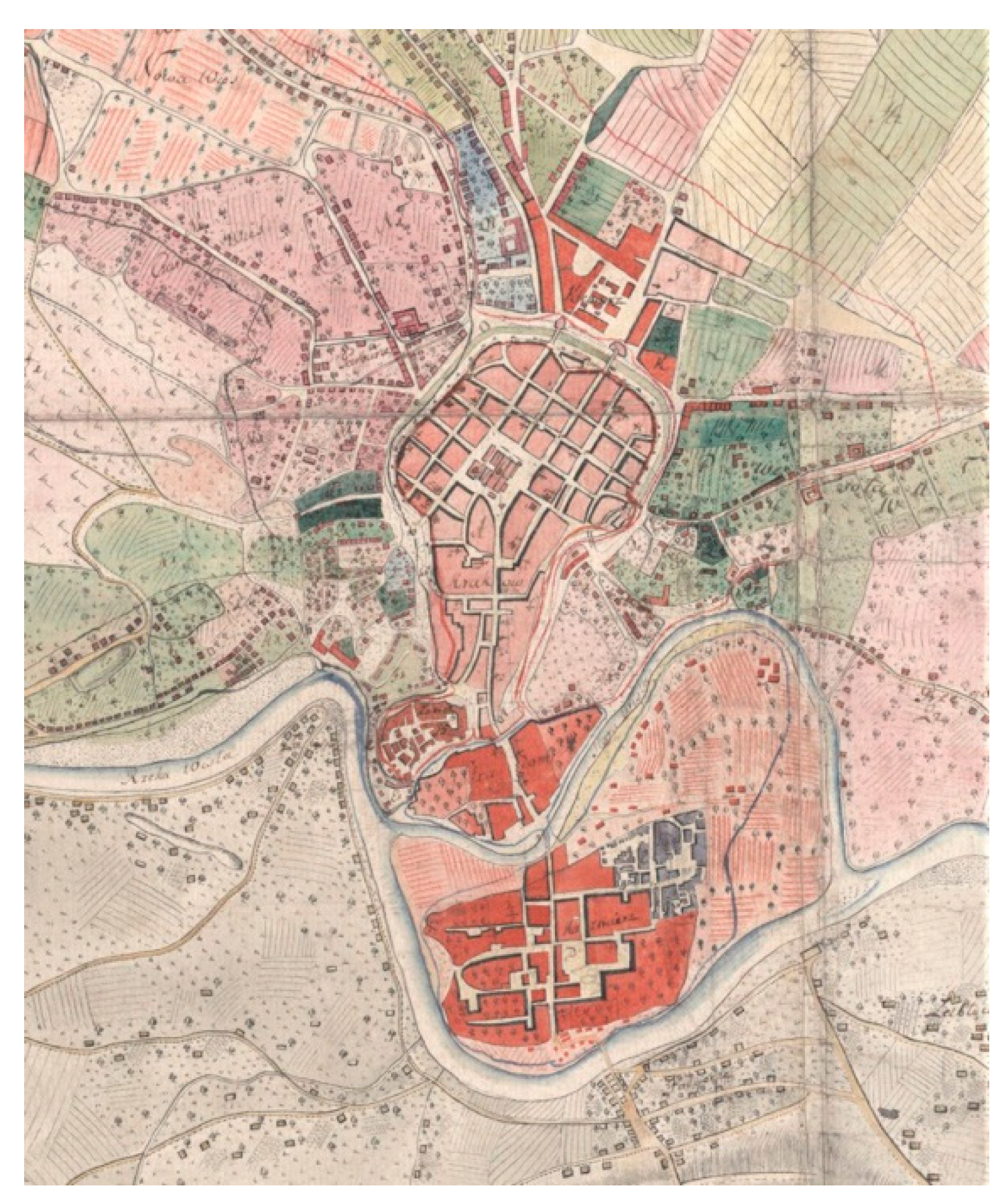
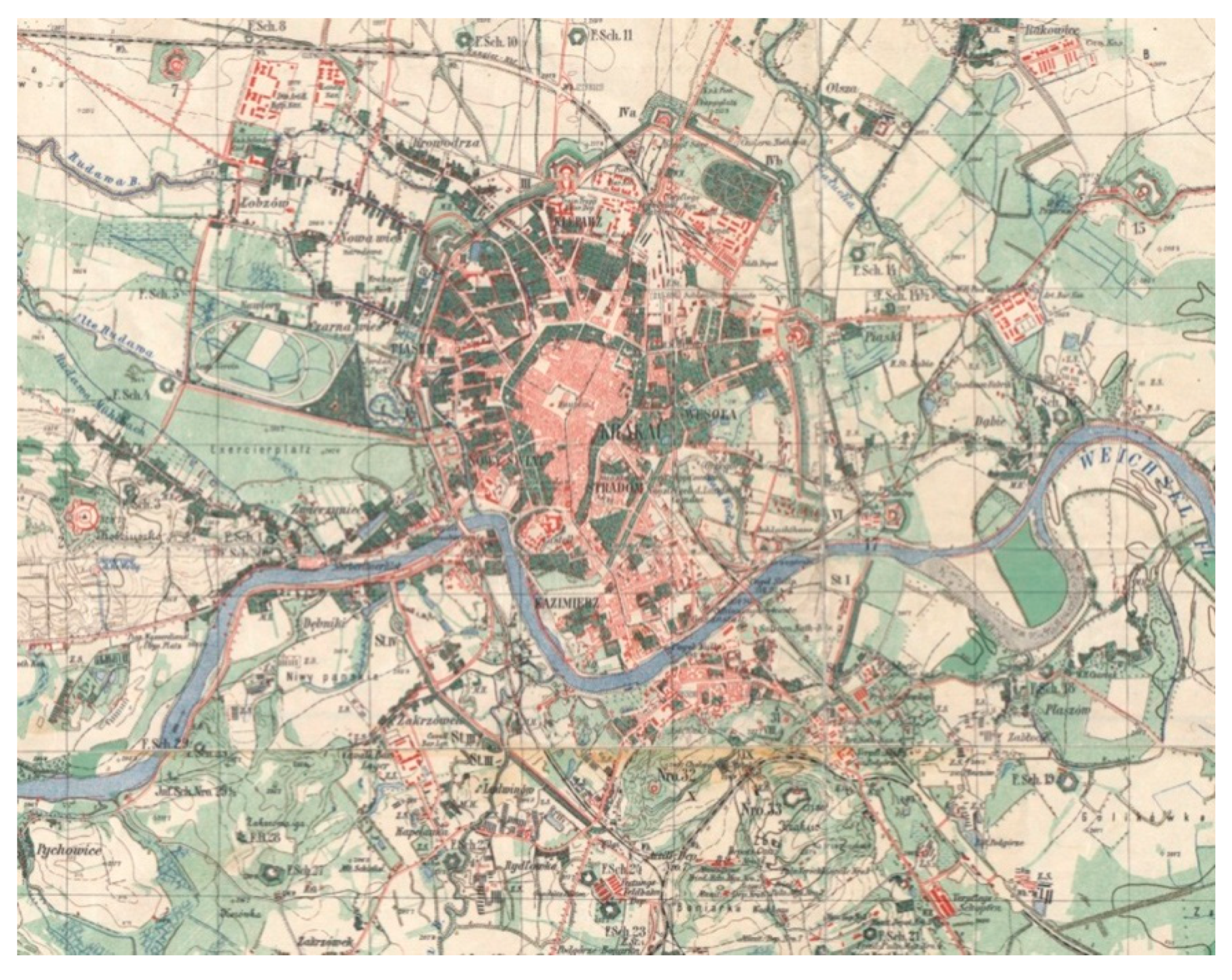
3.1.1. Krakow—A Brief History of Spatial Development

The oldest uncovered traces of the first settlements founded during the Mesolithic period amidst the bogs, swamps, and overflow areas of the Vistula River and its tributaries—that slowly meandered across what is now Krakow at the time—are over 10,000 years old. Wawel Hill was the most defensible area—a limestone hill located near a bend of the Vistula—and it was here that a defensive gord had been built and, over time, converted into a royal residence.
The spatial layout of all historical towns is, to a degree, dependent on the layout of watercourses. In the case of Krakow, this link is particularly strong and it has left a clear mark on its surviving structure of historical development. The knightly settlement at the foot of Wawel Hill, from its north-eastern side, in the area of what is now Kanonicza Street, and a market settlement located near what is now the Little Market Square, were placed on dry, safe land. Two trade routes intersected here, forking in the direction of two fords on the Vistula—one near Wawel Hill, which led towards Bohemia and Moravia, and one that led across an island that formed by two branches of the Vistula, on which the town of Kazimierz was to be founded later.
The naturally defensible character of the area was not enough for a timber and otherwise unfortified town to resist the Mongol invasions in the middle of the thirteenth century. Krakow burned down twice during this period. In 1257, between the first and the second invasion, King Bolesław the Chaste signed Krakow’s town charter: deprived of any graphical appendices, the document featured a description of the new town’s parcellation strategy that was based on the so-called Magdeburg law. The largest market square of Medieval Europe was delineated, along with a grid of streets and urban blocks further divided into plots. The new plan was adapted to existing elements, hence local departures from its rigid geometry, facilitating the uniqueness of the entire layout that has survived to this day. A similar principle was adopted during the founding of two additional towns that co-created Krakow’s Medieval agglomeration: the larger and richer Kazimierz (Casimirus) to the south (1333) and the smaller, more modest and unfortified Kleparz (Clepardia) to the north (1366), as well as the suburb of Stradom (Figure 1; Figure 2).
Periods of relative prosperity interweaved with political crisis during subsequent centuries. The latter were largely the deciding factors in the preservation of the town charter-period Medieval urban layout. There are neither Baroque axes, nor monumental Enlightenment-era districts in Krakow. Not even nineteenth-century burgher districts exist. A sort of a substitute of the latter are the so-called Planty Dietlowskie, built in the years 1878–1880 in the place of the buried former riverbed of the Old Vistula (Figure 2; Figure 3)—essentially a street that only echoes metropolitan boulevards.
The crises that stopped the city’s expansion and preserved its Medieval urban layout were not conducive to the preservation of its historical substance. Insofar as in the first half of the sixteenth century, when fires consumed both Wawel Hill and the town’s individual districts, the city rebuilt itself with great care and under the eye of the best Polish and Italian masters, but the gradual loss of significance that was associated with the relocation of the royal court to Warsaw after another fire at the castle was not favourable to maintaining this tendency. After the catastrophes of the seventeenth century—a great flood (1625) and two sieges of the town by Swedish forces (1655 and 1656–57), which ended with its complete destruction and many movable heritage objects being stolen—Krakow did not regain its former splendour.
In 1792, the Medieval agglomeration, along with its suburbs, was formally combined into a single city with an area of 46.9 km2 (the Old Town and Wawel Hill comprise an area of 0.89 km2) [30], and it was in this shape that it was taken over by the Austro-Hungarian Empire during the third partition of Poland in 1795. The city enjoyed relative autonomy and it was able to amortise the consequences of royal-imperial decisions for only a brief period of the partitions (1815–1846). When a decision to demolish the city’s walls was issued in 1810, it was possible to save only a small fragment of their northern section, with the Florian Gate, three towers, and the Barbican, while the site of the former moat was used to establish Planty Park—a belt of greenery surrounding the Old Town, today constituting one of Krakow’s hallmarks.
Two decisions stopped Krakow’s spatial development. The first was the relocation of the seat of the governorship of Galicia to Lviv and, as a consequence, Krakow losing its significance as an administrative centre. The second was assigning the status of a fortress to the city in 1850 (Germ.: Festung Krakau). As a result, Wawel Hill was redeveloped and fortified, while the city itself was surrounded with two rings of fortifications, which were supplemented with infrastructural buildings and other military structures and facilities. In the inner ring, inside a belt several-hundred metres wide, a demolition edict was enacted. In the case of military circumstances, every property within this belt could be demolished without their owners having a right to compensation. As a result, the processes of the coordinated urbanisation of the suburbs were put to a stop, which included the area of the railway station adjacent to the city’s military barracks. Despite this, or perhaps because of it, Krakow’s population density towards the nineteenth century exceeded 21 thousand people/km2—which was ten times more than the present figure [31] (p. 231).
During the interwar period, when Poland had regained its independence, Krakow partially developed on the basis of the so-called Plan of Greater Krakow of 1910, whose implementation was interrupted by the start of the Second World War, and that was largely based on the existing grid of streets and squares (Figure 3). During the Nazi German occupation (1939–1945) Krakow, the capital of the General Government, saw the construction of new housing districts, along with efforts aimed at germanising the city—town houses were remodelled to feature arcades, the colour of facades was altered, etc. The destruction brought by wartime operations was relatively small—the greatest damage that heritage buildings suffered was caused by a Soviet artillery barrage in January 1945—while the scale and consequences of the extermination of the local population are difficult to imagine. The transformation of the city’s demographic structure in terms of origin, education, and religion was completed by the start of the construction of the town and metallurgy plant complex of Nowa Huta in 1949. Although it was located 7 km to the east of the city, it was already incorporated into it two years later. The broad belt featuring grid-based circulation that was created between the city and its new district would gradually become filled in with housing estates and, over time, after the explosion of the free market economy—with big-box stores and parking lots.
The Spatial Planning and Development Act of 1994 [32] largely liberalised control over new development projects. On the 31 December, 2003 all previously enforced spatial development plans were voided, with lawmakers electing not to introduce a mandatory requirement to prepare new ones [33]. Individual projects and the change of the form of use of a given area (primarily from an agricultural use to a buildable plot) were coordinated neither on the local scale—as local spatial development conditions that were issued for every new development project proved completely insufficient for this purpose—nor on the scale of the entire city. Krakow has reached its current shape having been developed in a practically uncontrolled manner: it occupies an area of 324 km2, being officially inhabited by just below 770 thousand people (data for 2017) [34] and used by more than a million, including the residents of the metropolitan area (with an area of 4.065 km2), contract workers, students, and tourists. Its most important and well-defined element still remains the fragment with an area of 1.49 km2, the area of the Medieval Old Town, which constitutes a world heritage site of outstanding universal value [35,36,37].

3.1.2. Krakow—Forms and Strategies for Protecting Built Heritage

The legal basis for the protection of the Old Town along with Wawel Hill, Stradom and Kazimierz (Figure 4) as a UNESCO World Heritage Site is the Convention of 1972, ratified by Poland in 1976 [38]. Section 97 of the Convention’s operational guidelines states that “all properties inscribed on the World Heritage List must have adequate long-term legislative, regulatory, institutional and/or traditional protection and management to ensure their safeguarding. This protection should include adequately delineated boundaries”. The 1985 Convention for the Protection of the Architectural Heritage of Europe [39] requires its signatories to, among other things, appropriately supervise and enact regulations for the issuing of decisions and to create an integrating heritage conservation policy.
The scope and requirement of heritage protection is specified in the Historical Monuments Protection and Preservation Act [40,41]. The Act of 2003 [40] necessitated the inclusion of protective tasks in spatial planning and development, as well as the shaping of the environment (Art. 4, section 4); however, it specified neither the scope nor the assessment criteria for such actions. The Act of 2010 [41] made it mandatory to establish new heritage site lists: a national list [42], as well as voivodeship and municipality-level lists. Within Krakow’s city limits there are 1218 heritage sites that are listed in the historical monuments registry and placed under full protection (data for June 2019) [43], as well as 6359 sites that were listed in the municipality heritage site list (data for May 2018) [44] placed under supervision and partial protection.
Related acts among which the Construction Law Act [45] and the Ordinance on the Matter of the Technical Conditions that Must be Met by Buildings and Their Placement [46] feature provisions that largely concern the possible lifting of the applicability of the necessity to adapt heritage buildings to certain technical requirements.
Guidelines that are found in the conventions and the act are meant to shape local law. The Advisory Body Evaluation document (ICOMOS) of 2010 [37] imposed an obligation to extend the protection of the world heritage site to include a buffer zone (Figure 4), in accordance to section 103 of the UNESCO Convention Guideline [38]. This was confirmed by a provision in the Spatial Development Study of 2014 [47,48] (Figure 5). The recommendation to cover the entirety of the buffer zone with a local spatial development plan (LSDP, MPZP in Polish) has not been implemented to this day [49].
On 13 February, 2019, the final version of the Old Town Cultural Park protection plan, which had been processed since 2010, was approved [50]. Based on this resolution, prohibitions and restrictions regarding the conducting of construction work, commercial and service activity, the placement of advertising media and visual information media, as well as the collection and storage of waste have been enacted.
All of the currently applicable protection strategies are based on protecting the originality and integrity of the substance and form of heritage sites as the results of a historically closed process [50,52]. Such an approach, according to the modus tollendo tollens principle, suffers from a methodological error. In addition, the scale, intensity, and chaos that are present in spatial development policy have all led to a situation in which the Old Town area, with a resilient form and function in its former functional, spatial, demographic, economic, and—perhaps most importantly—environmental context, is becoming a vulnerable one. Its protection in the context of threats generated by the city, of which it is a central and integral part, cannot be boiled down solely to a building, or a complex of buildings and their substance, while the goal of the modernisation of public spaces should not be restricted to their aestheticisation.

3.2. Krakow—An Agglomeration Built on Wetlands and Dwelled by One Million Inhabitants

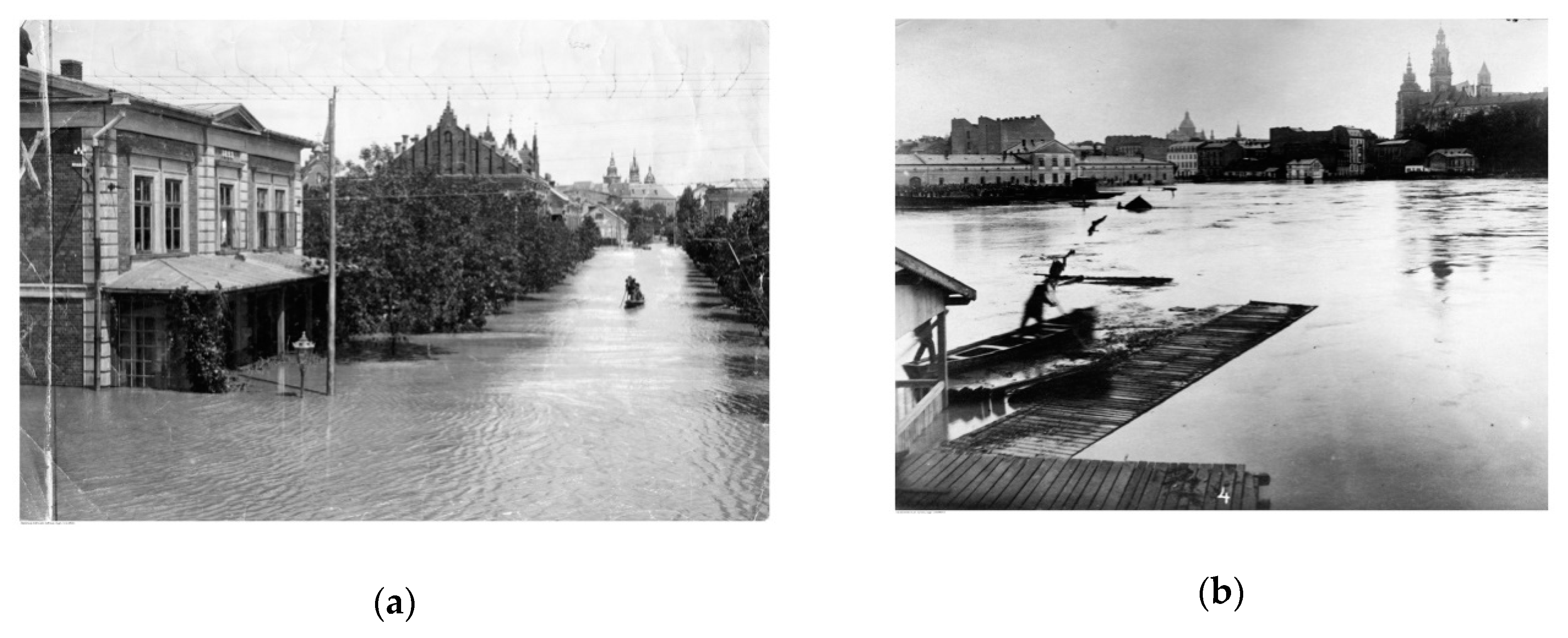
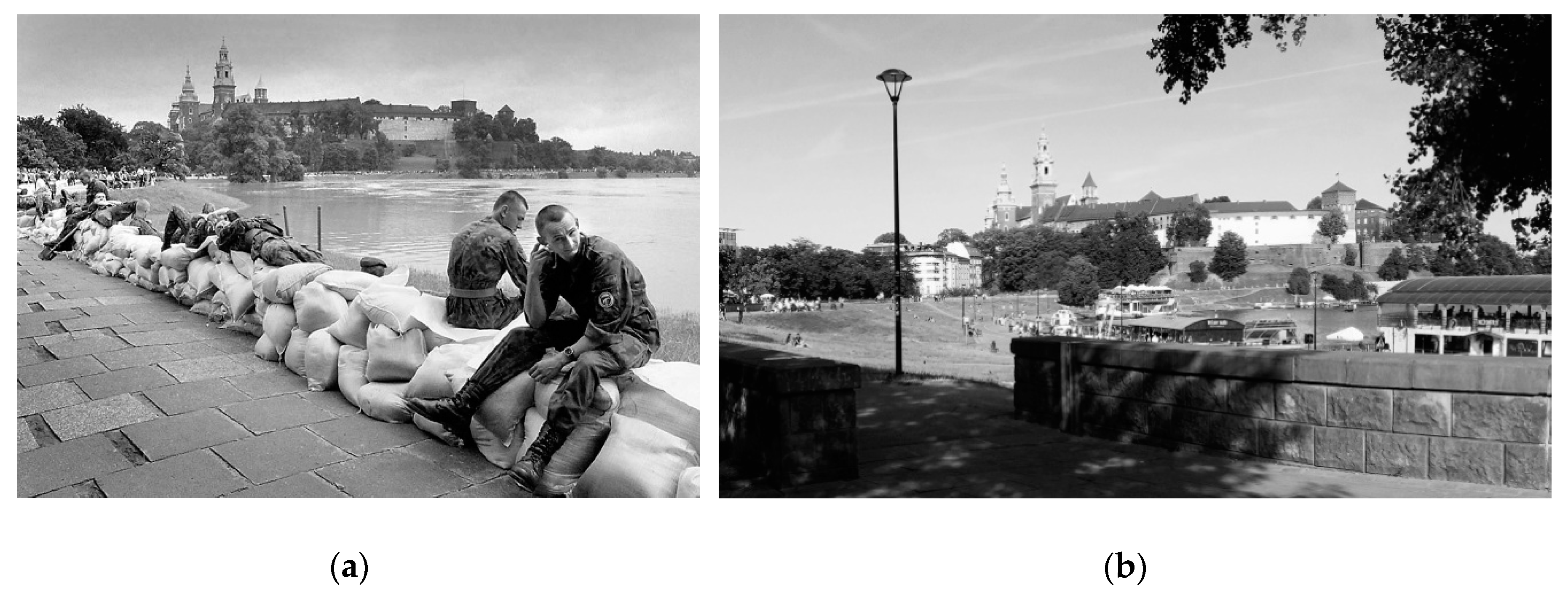
3.2.1. A Brief History of Flooding in Krakow

Throughout its history, Krakow has survived many severe floods. These were primarily fluvial floods that did not display a tendency for regularity, although they were quite numerous. One of the largest and the first well-documented one was the great flood of 1813. Since the beginning of the 20th century, the largest and most catastrophic floods, both in terms of territorial range and hydrological significance, occurred in 1903, 1925, 1934, 1970, 1997, 2001, 2004, and 2010 [Table 1] [5,53,54,55]. Photographic documentation making it possible to assess the scale of the destruction has survived (Figure 6).
The cause of the flood of 1997 was intensive rain. However, natural causes were not the only things at the foundation of the magnitude of this flood. There was the inappropriate technical condition of a significant portion of flood protection infrastructure along with imperfect legal regulations, and poor communication with the local population prior to, during, and after the flood. The lack of knowledge and effectiveness concerning crisis events also played their part. In Krakow, the passage of the flood wave was associated with the flooding of areas adjacent to rivers due to the closing of embankment floodgates and the inability of storm drains to effectively drain the water. A critical situation to the safety of the Dębnicki Bridge also developed—the space underneath the bridge was almost completely filled, with only the central, tallest point having around 1 m of space between the underside of the bridge and the water surface. According to Pawłowska [57], this bridge is a sort of indicator of the threat level to the Old Town, as its height is only slightly greater than the elevation of some of its most precious historical parts.
The flood of 1997 initiated studies regarding increasing the height of the existing Vistula River boulevards that protect the Old Town from flooding, which started recently. The proven hazard level led to the acceptance of the proposal to build additional retaining walls with a height of around 1 m, which were initially criticised as interfering with the landscape of historical areas and buildings. The project to increase the height of the embankments was supported by landscape analyses, with different solutions being used depending on the visual assets of a given area’s vicinity and, apart from a concrete retaining wall, the areas were also secured with demountable barriers, meant to be erected only when the hazard presents itself [57]. Apart from the Vistula River boulevards, almost the entirety of the city’s flood embankments was assigned for modernisation. The design and construction work that began in 1997 is being carried out to this day (Figure 7).
In 2000, the Council of the City of Krakow approved the local plan for limiting the effects of flooding and flood prevention for Krakow. The primary objective of this plan was to define the technical and non-technical measures (to be taken prior to, during, and after a flood) that are for necessary increasing the city’s flood safety, based on identifying Krakow’s flood hazard [58].
In 2010, an even more severe flood, the greatest since 1813, affected Krakow. The fact that the duration of the proper flood control effort amounted to 22 days and the peak recorded water level on the Vistula River during the flood in Bielany was 957 cm is sufficient for illustrating its magnitude. In Krakow, the flood-wave peak achieved a value that was higher than during preceding floods (except than the one in 1813), this time causing the space underneath the Dębnicki Bridge to become completely filled and the bridge itself—a key element of the second ring of the city’s circulation system—was closed. The greatest losses were caused by embankment breaches and damages of the Vistula low boulevards in the city centre, which required around 300 people to be evacuated [59].

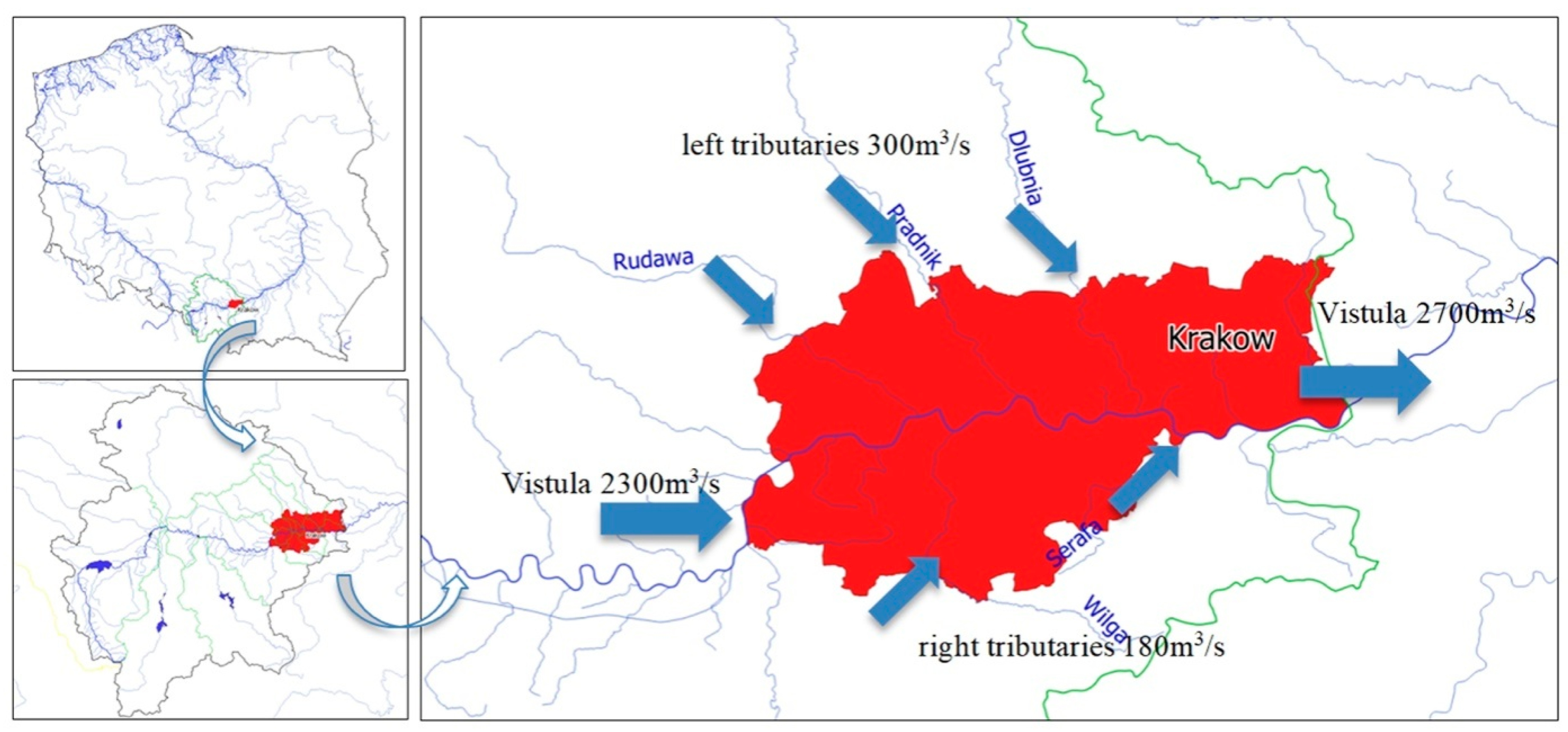
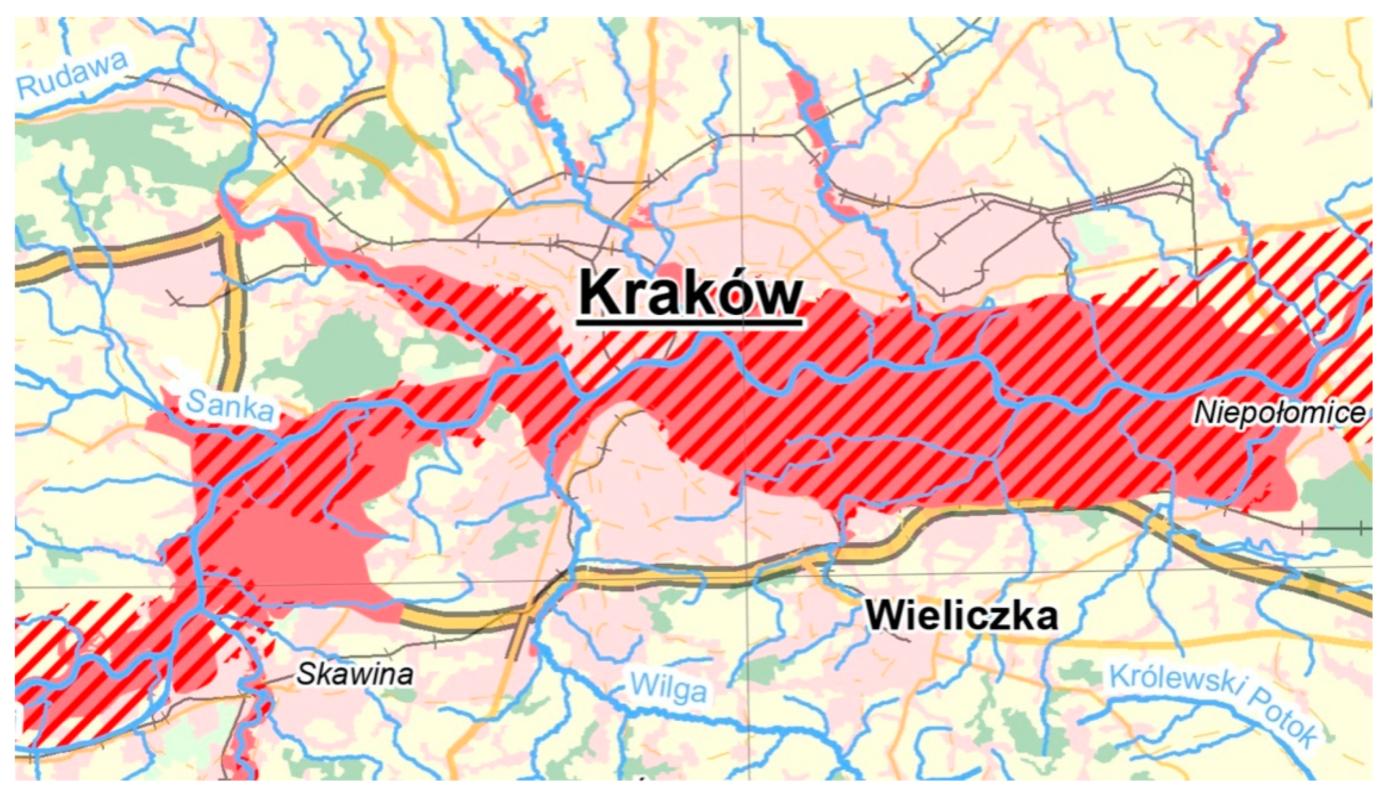
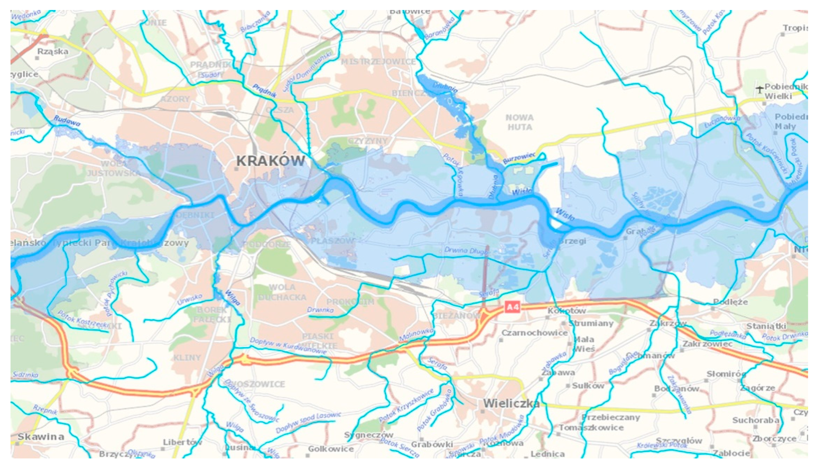
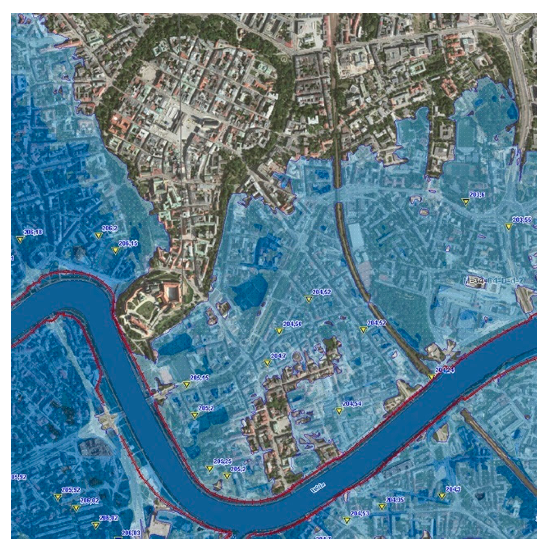
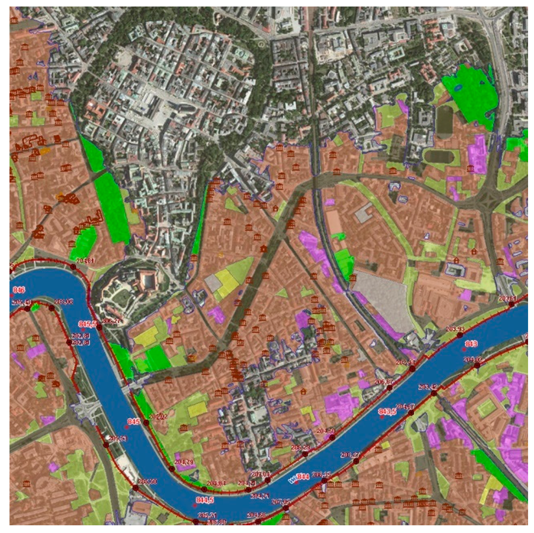
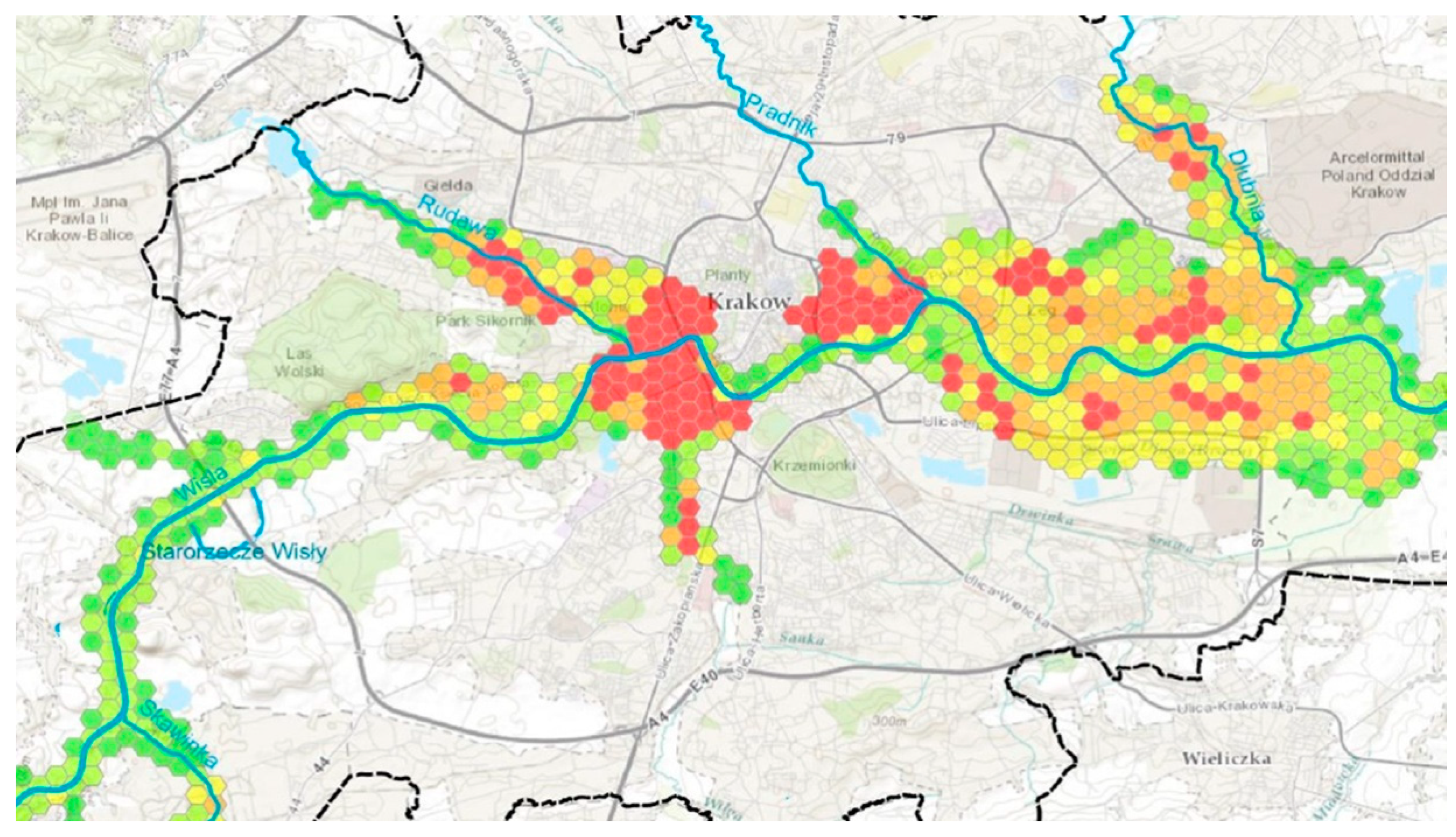
3.2.2. Hydrographic Context and Risk Factors

The flood hazard of the city of Krakow is a result of many types of threats. First, the area of the Vistula River basin, exceeds 8800 km2 in its closing cross-section downstream of the city, of which around 85% is the Vistula River basin upstream of Krakow. The Vistula’s tributaries that flow into it within the city limits are an additional threat. The combined area of the river basins of all of the tributaries that flow into the Vistula within the city limits is around 1200 km2, out of which as much as 900 km2 is in the areas of neighbouring municipalities (Figure 8). As a result, in the case of the Vistula River basin upstream of Krakow, as well as in that of a significant area of direct tributaries, the city does not have the ability to control changes that take place in the outflow from the tributaries that flow into the river. Thus, it is merely a passive receiver of outflow that is subsequently increased by the constant and progressive process of the urbanisation of the surrounding municipalities.
The Vistula River’s barrages are an additional threat. They are composed of six damming barrages that were built in the years 1949–2002, of which three are located within the city limits. Under normal conditions they stabilise the water level within the city, but in the case of a flood, they increase flood risk due to the additional damming of significant water surges [61]. This particularly applies to the barrages located within the city limits. Furthermore, the barrage structures, in particular the construction of the Dąbie barrage, has led to a rise in the groundwater table in inner-city areas adjacent to the Vistula, along its section from the mouth of the Rudawa River to the Dąbie barrage, which feature historical buildings and complexes, as well as a significant part of the area placed on the UNESCO World Heritage Site List and its buffer zone. A draining barrier was designed, featuring 37 drainage wells, which are placed on both sides of the Vistula in order to maintain a safe water table level (Figure 9). Water is pumped from the wells to a combined sewer network or directly to the Vistula and its tributaries (the Wilga and the Rudawa) [60], however, rivers are incapable of receiving water during a flood. This is a significant factor that increases the flood hazard in the features of the construction of the structures and the densification of development in the city centre. Any interference with the existing geological system disrupts hydrogeological conditions and it can cause a local, groundwater-based increase in flood risk when combined with heavy rain, which seems underestimated in the case of many of the new investments that have foundations going as deep as a dozen meters below ground level.
Krakow’s sewerage system is predominantly a combined sewer system (sewage water and surface runoff are transported while using a shared pipe or tunnel) in the central areas of the city, while in its outer areas a separate sewer system is utilised (sanitary sewage and surface runoff are transported separately). In those districts of Krakow that are undergoing urban development, it is the Vistula’s tributaries that are surface runoff receivers, both directly and through sewerage. Outfalls that discharge storm water (of which there are 38), which are located at the combined sewer collectors, all feature shutters—locks that prevent the rising waters of the Vistula from entering the sewers and flooding the city. In the case of closed locks on the storm water outfalls, the sewerage cannot drain surface runoff from rain greater than 20 mm [60].
Current surface runoff management solutions pose threats whose primary sources are the lack of the retention of surface runoff; the inefficiency of the current combined sewerage and storm drain systems, which in many areas of the city are incapable of draining and transporting surface runoff, and it results in flooding in heavily developed areas; in addition to the inability to discharge water through storm water outfalls during periods of flooding (when the Vistula’s water levels are high), as their outlets are located below the flood water levels.

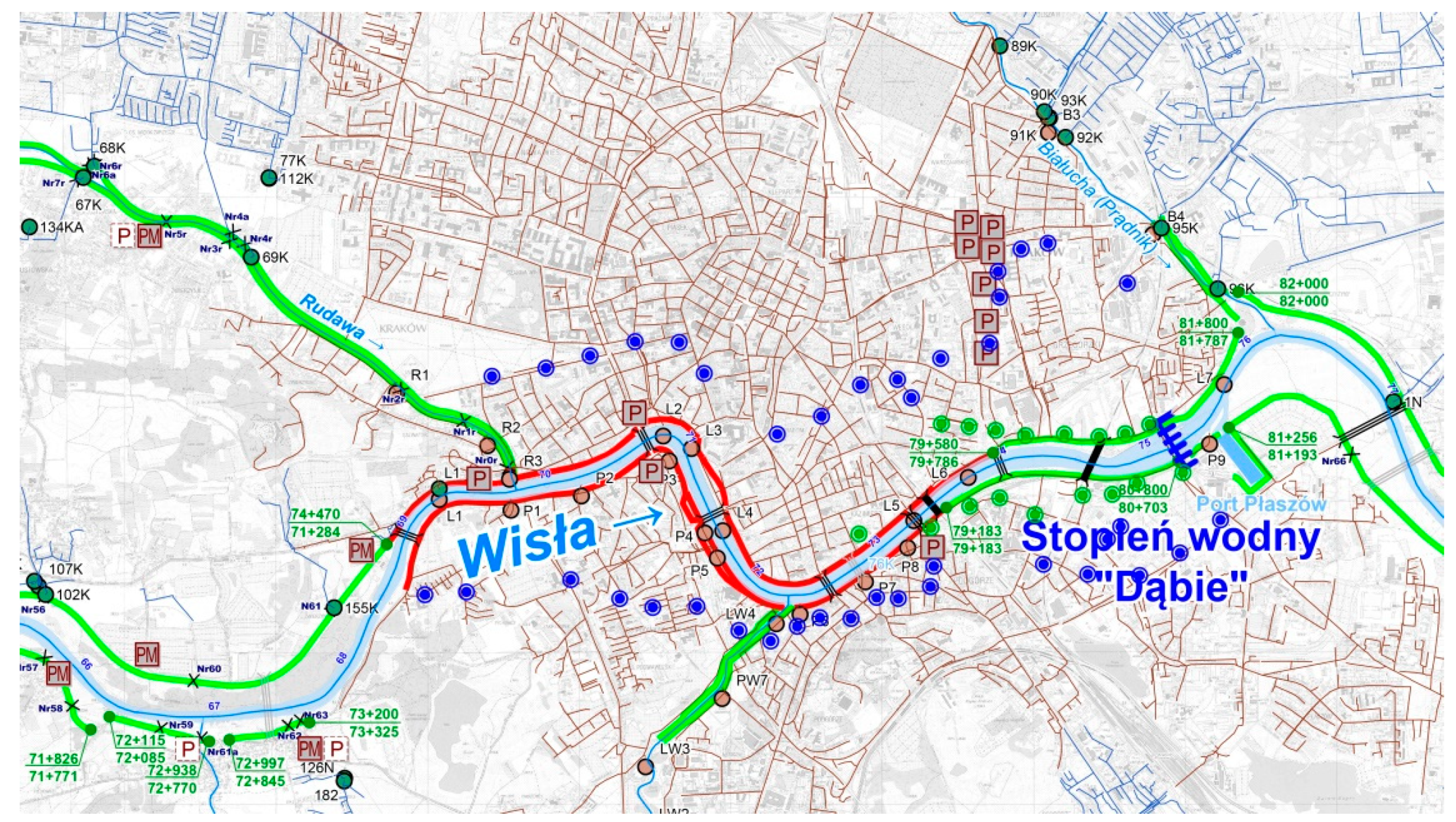
3.2.3. Protection Strategies

Krakow, which had been severely affected by floods in the 19th century, initiated large flood protection projects at the turn of the 20th century. At that time, the Vistula River was regulated, becoming a single stream, the riverbeds of the river’s former branches were buried, including the Old Vistula, while the confluence section of Rudawa, a large tributary, was relocated, the Młynówka Królewska was canalised and protective walls were built around the Vistula, which formed the Vistula River boulevards [57,62]. Due to the regulation, the Vistula’s inner-city section has a width that is a third of its downstream and upstream sections. In addition, the inner-city section of the Vistula is composed of sharp bends with very short arch radii, and the riverbed is hemmed in by dense urban as well as bridge and road development. This directly affects the risk of the water flooding into the city, the destruction of the lower and upper boulevards, as well as bridge structures due to a rise in forces that act on them during high and highly varied flows and flow speeds both in terms of cross-section and speed. This factor also shows an upward trend, and constantly increases flood hazard in the city.
Decisions that were made over a hundred years ago affect the present, as the adopted solutions in terms of protecting the city through flood embankments (concrete boulevards in the inner-city section and earthen embankments along the remaining sections) were, and still remain, the primary safety measure of the city. The current flood protection system of Krakow is based on embankments of the Vistula on both of its sides along the entirety of the river’s course within the city limits, while the flood embankments along the main tributaries along their confluence sections, which protect nearby areas against backflows. Along the inner-city section, the protective measures take the form of boulevard floodwalls, which are themselves under protection and parts of them are listed as heritage structures. It is the narrowest section of the Vistula, which is conducive to the rising of the water level during high flows and an increase in the erosive force that puts the riverbed under threat of deformation and puts the safety of the boulevard floodwalls at risk. The embankments were modernised numerous times, with the latest significant changes being introduced after the flood in 1997, when the boulevards were extended upwards through the construction of retaining walls with the option to attach additional temporary floodwalls. The combined length of the Vistula’s embankments and those of its confluences within the city limits amounts to around 98 km [60,63].
Flood protection is also provided by water retention in reservoirs in the drainage basin upriver of Krakow; however, their impact is low due to their distance from Krakow (35 and 70 km in a straight line from Krakow, and 65 and 100 km, respectively, while traced along the course of rivers:), as well as the limited size of permanent flood reserves.
In Poland, flood risk management is based on cyclical planning (performed every six years), which is comprised of preparing four planning documents, as recommended in Directive 2007/60/WE on the assessment and management of flood risk [23,64]: Preliminary flood risk assessment (WORP), which is meant to identify sections of river valleys with significant flood risk, for which flood hazard maps and flood risk maps will be prepared first; Flood hazard maps (MZP), which depict the boundaries of areas that are under the risk of the occurrence of p = 1%; p = 10% and p = 0.2% flooding and areas under the risk of flooding because of embankment breaches during a p = 1% flood; Flood risk maps (MRP), which depict the potential losses that can be incurred in areas depicted on flood hazard maps, combined with areas under flood hazard because of embankment breaches; and, Flood risk management plans (PZRP), which cover a listing of measures meant to minimise the identified hazards and limit potential negative consequences of floods on the life and health of people, the environment, cultural heritage, and economic activity, i.e. the purpose of flood disaster mitigation as stated in Art. 1 of the flood directive [23].
All of the abovementioned four documents should refer to threats to cultural heritage. For instance, the Water Law Act and its executive ordinances [65,66] specify that WORP documents should feature analyses that cover the descriptions of historical floods that have caused significant adverse effects to human health, the environment, cultural heritage, and economic activity. As a part of preparing flood risk maps, two types of maps are to be prepared: (1) flood risk maps showing adverse consequences for the population and the value of potential losses as a result of flooding and (2) flood risk maps depicting the negative consequences for the environment, cultural heritage, and economic activity. During the first planning cycle, the maps depicted cultural heritage areas and sites that were divided into five categories: (1) heritage area, site; (2) site inscribed in the UNESCO list; (3) genocide memorial; (4) open-air museum, museum; and, (5) library, archive.
A preliminary flood risk assessment was first performed in 2011, while, at present, as a part of the second planning cycle, a review, and update of the Preliminary Flood Risk Assessment (aWORP) was performed (2018). As a result of the update, the area under flood hazard was made smaller (Figure 10). Due to this change, the most important built heritage areas—the Old Town—are not classified as an area at risk of flooding. This change is a result of taking into consideration the provisions of the flood risk maps and flood risk management plans that led aWORP authors to conclude that the current technical safety measures for this area significantly limit the flood hazard, providing a basis for the introduction of such an amendment. However, a large part of the area inscribed in the UNESCO World Heritage Site List and a significant part of its buffer zone have been marked as an area at risk.
It is noteworthy that, in terms of taking cultural protection into account, the methodology of flood risk assessment as a part of the WORP has been changed. During the second cycle, apart from an assessment of the impact of flooding on economic activity and infrastructure, the criterion of the impact of flooding on cultural heritage has been included, being measured as the density of heritage sites within the analysed area [68].
The results of the preliminary flood risk assessment, i.e. identifying areas at risk of flooding, is grounds for preparing flood hazard maps (MZP) for these areas. The MZP maps show areas with a specific probability of flood occurrence: areas in which the risk of flooding is low and amounts to 0.2% (once per 500 years) or in which there exists a probability of the occurrence of an extreme event; areas in which the probability of flooding is average and amounts to once in a hundred years (1%); areas in which the probability of flooding is high and amounts to once in ten years (Q 10%); and, areas that are under flood hazard in the case of embankment breach or the failure of a hydrotechnical structure (Figure 11).
MZP maps, which depict, among others, the range of flooding, were then used to prepare flood risk maps, which include a population risk map and flood damage map, which includes information regarding the size of the population in danger from flooding in a given area and the potential value of the losses that are caused by flood damage, indicatively assessed for such land use classes as housing areas, industrial areas, agricultural areas, circulation areas, recreational areas, and forests; it also includes a map of protected areas and of economic and industrial activity, which only depicts the industrial installations, water sources, recreational areas, and wildlife protection areas, etc. Cultural heritage is marked only by points symbolising the location of heritage buildings, while palatial complexes were shown as zones—while areas under protection as UNESCO World Heritage Sites were not included (Figure 12; Figure 13).
The final document of the entire planning process is the flood risk management plan (PRZP) for a river basin. In the case of Krakow it is the Vistula River basin, and the plan was approved by the Ordinance of the Council of Ministers in 2016 [69]. Five main objectives and 14 detailed objectives have been defined for the PRZP. The primary objectives include [64]: preventing an increase in flood risk; minimising existing risk; minimising consequences during a flood; minimising consequences after a flood and formulating conclusions; and, developing instruments to support the implementation of legal, financial and information measures.
The selection of actions that are meant to ensure a decrease in flood risk was performed on the basis of alternative analyses of possible flood protection methods, while taking into consideration their efficacy and economic efficiency. The selection of the optimal alternative was performed by using a multi-criteria analysis. Among the 16 assessment criteria that were used there was also the criterion concerning possible impact on cultural heritage. All the criteria of the analysis were divided into four categories of assigned weight in evaluation: (1) economic, with the weight of 15%; (2) social, with the weight of 30%; (3) environmental, with the weight of 22%; and, (4) flood-related, with the weight of 34%. Cultural heritage was among the six criteria included in the social category. Its weight within the category was equal to 21%, which gives a weight of 6% in the total evaluation. It does not discriminate this criterion; however, it does not allow for differentiating among specific objects and sites. Furthermore, it does not refer to either the UNESCO heritage site or its buffer zone [cf. Figure 4]. Hence, it ignores the 1972 Convention [38] and the 1985 Convention [39]. As a result, this criterion is insufficient to provide correct flood risk management in relation to this type of areas and sites. It appears that it would be necessary to prepare a different, more comprehensive criterion for the next planning cycle, one that would enable the relative evaluation of heritage areas and sites and allow for taking the presence of the UNESCO world heritage site into consideration.
Analyses that were performed for Krakow covered not only the area of the city, but also the upstream section of the Vistula (from the mouth of the Soła River), because of the fact that the threats (fluvial floods) are largely generated there. Analyses also included the Vistula River section downstream of Krakow (to the mouth of the Nida River), as the flood risk is transferred there (Figure 14). The threat identification that had been performed led to the conclusion that the existing infrastructure in the form of embankments (and its parameters and technical condition), as well as the character of areas being protected (development of high value which constantly increases), does not provide the desired safety level. It was estimated that an embankment failure could result in around a quarter of the area of the city becoming flooded—including housing areas, infrastructure, strategic industrial plants, and numerous world-class heritage sites [70].
The variant covering an increase in the Vistula River’s valley retention through the construction of dry polders along its shores, along the section from the mouth of the Skawa to Krakow, by setting back or dismantling embankments and the modernisation of selected existing embankment sections, was selected as optimal and leading to the lowering of flood risk for Krakow. In addition, non-technical measures were planned—improvements to the meteorological and hydrological event forecasting and alert systems. The planned cost of these endeavours is around 940 million PLN (220 million Euro), while the effects are estimated to result in lowering flood damage losses by 710 million PLN (165 million Euro) and lowering 1% flood water flow by 243 m3/s.
Of note is the fact that during the first planning cycle Poland did not take the risk associated with flooding from groundwater and pluvial floods into account, only focusing on fluvial floods [64,71,72,73,74,75,76]. During the second cycle, attempts are also made to take these types of flood into account, but the pluvial flood consequences analysis had an estimative and qualitative character because of insufficient data, with areas at risk of pluvial floods and floods being caused by groundwater remaining unspecified yet again because of the lack of data [68].
According to the Water Law Act [65], responsibility for the task of flood protection falls not only on the central government administration, but on the local one as well. Krakow was included in, among others, the regional Upper Vistula basin flood protection programme, approved in 2011 by the Council of Ministers [77]. The programme was meant to coordinate efforts across five voivodeships and ensure funding for measures that are associated with flood protection. The tasks of the Programme were being implemented for close to four years, becoming voided after the preparation of the PRZP for the Vistula River basin, but its provisions were used during the preparation of the PRZP.
Apart from national plans, local plans are also being prepared, with significant documents for Krakow in terms of flood risk management including, among others, The Local Flood Effect Minimisation and Flood Prevention Plan, prepared in 2000 by the Office of the City of Krakow in cooperation with central and local government administration agencies that are responsible for flood protection in the city [58]. It was successively implemented and applied, with the city publishing yearly reports on its implementation in the years 2005–2018. The plan was voided in 2018 due to the approval of the Flood Effects Minimisation and Drainage Plan for the City of Krakow; The Flood Effects Minimisation and Drainage Plan for the City of Krakow—prepared by the Office of the City of Krakow [78], and approved for implementation in 2018; and, The 2030 Climate Change Adaptation Plan for the City of Krakow [79].
The Flood Effects Minimisation and Drainage Plan for the City of Krakow is a local municipal sectorial plan, but it functions in connection with the city’s strategic planning documents, including the “This is where I want to live. Kraków 2030” City Development Strategy [78,80]. The plan defines the following goals: the strategic goal—creating a city that is friendly to live in, as well as operational goals—a sustainable environment and a high safety level in Krakow. As key measures meant to implement these goals, the plan assumes the modernisation and extension of municipal infrastructure and the improvement of crisis management [78]. This plan also does not feature direct references to building heritage areas and sites.
The 2030 Climate Change Adaptation Plan for the City of Krakow was prepared as a part of the Ministry of the Environment’s national project entitled “Preparation of climate change adaptation plans for cities with more than 100 thousand inhabitants”. Krakow participated in the project as one of the 44 Polish cities that did so. The plan includes a diagnosis of major threats, among which the following have been identified as the most significant: heat waves, non-rainy periods, torrential rains and storms, fluvial and pluvial floods, and air pollution. The plan specifies a series of adaptive measures, the implementation of which is to lead to an increase in the city’s resilience to the effects of these threats, including water-related risks [79]. The plan does not directly refer to building heritage areas and sites, however it does so indirectly by means of the planned measures for high-density housing areas that, of course, cover the area of the Old Town. The planned measures meant to improve the city’s resilience to water-related risks include: blue and green infrastructure, the modernisation of flood embankments, and the establishment of a surface runoff management and usage system. The estimated costs of the implementation of the informational and educational, organisational, and technical measures are around 8,2 billion PLN (1,9 billion Euro), while their implementation has been planned for the next 12 years.

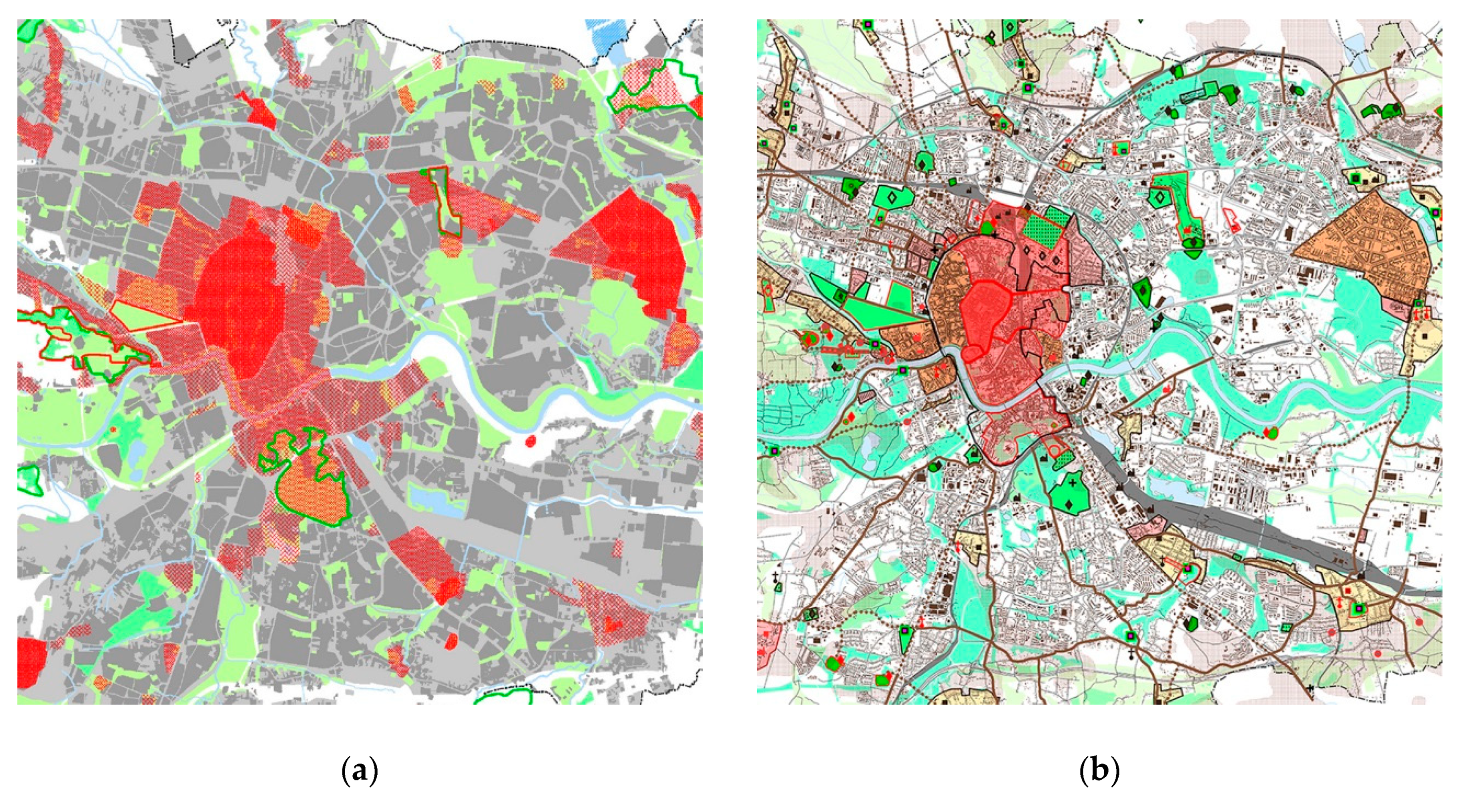
3.3. Krakow—A Single-Hazard City?

Floods are currently the most significant, if not the only threat included in protection plans and strategies. At present, the only essential problem, one that has a constant, rather than a catastrophic character, but one that has a catastrophic dimension, is environmental pollution—primarily air pollution. Poland has the worst air in the entire European Union and at the same time the most liberal regulations concerning informing society about air quality [81]. Concentrations that in many European Union Member States are considered as alarming levels are treated as permissible in Poland. For instance, the PM10 alert-level average 24-h concentration is 300 μg/m3 (in the Czech Republic, Slovakia, and neighbouring countries that, similarly to Poland, used to belong to the Eastern Bloc, alert-level concentration levels are 100 and 150 μg/m3, respectively). Low air quality during summer makes heat waves that keep hitting the city even more severe. There is no political will to limit air pollution and climate radicalisation by securing the necessary reserves of green open areas and constraining the filling of the city with concrete or even reversing the process altogether. Blue-green parks featured in the latest protection strategies and their drafts are limited to using these labels to describe the already existing areas. Their protection, although undoubtedly necessary, will not be sufficient.
Climate change forecasts for the region assume increasingly frequent and longer heat waves with less frequent but increasingly torrential rains, which lead to increased flood hazard and the soil turning barren. Perhaps the integration of flood protection, built heritage protection as well as smog and climate change prevention strategies could help to convince stakeholders to limit the share of free-market mechanisms in the shaping of the city. The current atomisation of these strategies is not conducive to a systemic take on the problem, in which the individual elements have a permanent influence on each other. Of note is the fact that a sizeable portion of the stone elements and sculptural decorations in the area under protection has been irreversibly damaged by acid rains (up to the 1990’s Krakow was surrounded by a greater amount of industrial plants that were equipped with poorer filtration systems than those used today). What follows is that both surface runoff retention and its impact on heritage sites cannot be solely analysed in a quantitative manner, ignoring its chemical makeup.
Local temporary measures are also necessary in light of the lack of political will to counter climate change itself, instead of merely its consequences—on 20 June, 2019 Poland, declaring the welfare of its citizens and entrepreneurs as justification, blocked the introduction of regulations concerning achieving energy neutrality by the EU by 2050.

4. Discussion

The article presents the multitude and complexity of factors that are responsible for Krakow’s vulnerability, including that of the historical urban complex and the resultant difficulties in the formulation of protection priorities. An interdisciplinary analysis allowed for shedding some light on problems of local, regional, and global scale:
  • Different water-related risks are treated separately.
  • Traditional, technical approach to eliminating water-related risk is becoming inadequate in the case of complex urban systems, in particular those containing built heritage sites.
  • Lack of coordination and correlation of different actions and countermeasures, including non-complementary tools and legal regulations, results in limited efficiency of atomised sectorial strategies.
  • Using solely quantitative criteria in risk estimation, risk mitigation strategies and protection strategies and ignoring qualitative ones, as well as an intrinsic relation of the urban system, is one of the methodological weaknesses of the standards that are still considered to be valid.
  • Additional factors, as well as non-infrastructural countermeasures, are still being underestimated, despite new approaches and guidelines being declared or established on different levels, be they local, national, or global [82].
  • Definitions and limits of protected areas should be revised as the case study presented here proves that the area covered by the protection strategies is and must be bigger than the protected area itself.
The necessity of abandoning the sectorial approach to planning, protection, and management resulting from the article fits in with the latest UN guidelines [83]. Unfortunately, Polish methodological standards and—perhaps most importantly—planning, design, and construction practice seem to ignore this necessity. Hence, despite the constant development of methodological approaches, risk, including flood risk, remains the subject of narrow, sectorial analysis. What is worse, the solutions that are employed are still among the traditional, single-task technical ones. As presented in the paper, especially in the context of built heritage, non-coordinated sectorial actions in the field of risk and climate change crisis mitigation are ineffective. It should be noted that a solely quantitative consideration of built heritage in protection strategies as their passive object will result in the construction of costly flood prevention infrastructure, the maintenance of which will become more expensive. Meanwhile, just as the protection of a built heritage area should start outside its borders (the buffer zone), flood protection measures should be introduced not only outside of the zone, but also inside it.
The rigidity of the current built heritage protection strategies—oriented towards the preservation of form and substance and treating the city as a historically closed creation—is not conducive to adapting the city to the growing threats that it faces. Insofar as measures that aimed at a single building or a complex thereof can be focused on its form and substance, this being the subject of decisions made between the developer, the architect, and the voivodeship conservator of historical monuments, the plan should coordinate them at the higher level of relations. At the same time, as the analysis presented in the paper suggests, in the context of other negative factors ranging from gentrification of the city centre, through intensive and non-coordinated urbanisation of the peripheral areas, to the consequences of climate change, current atomisation of the separate sectorial strategies might significantly limit efficiency of any of them. Additionally, on the contrary, if properly coordinated, they can support and consolidate each other, and the fixed costs in one sector will become countermeasures in another, making the zero-sum game [13] of the city budget possible.
The analysis of Krakow’s protection strategies—both those concerning the protection of built heritage and the historical layout of the city and its flood protection strategy—constitute a starting point for a discussion about what should be the subject and object of protection and how, provided that the adopted development model increases the threat to the protected heritage area—and the abovementioned gentrification of inner city areas and uncontrolled urbanisation. It also encourages further studies on flood protection measures that are different from infrastructural solutions—particularly those that come at a high energy cost, due to the fact that energy generation in Poland is still based on burning fossil fuels. Currently, there is a lack of political will to change this state of affairs—or even to search for and define new integrated protection paradigms, which include qualitative criteria, instead of merely quantitative and economic ones [82,83]. Perhaps Poland and Krakow, and its historical Old Town along with it, will soon have to learn to live with the heat and not despite of the heat, abandoning the controlled regulation of the natural environment in favour of controlled deregulation and live with water, instead of in spite of it.

5. Conclusions

In Poland, fluvial flood risk is practically the only water-related risk discussed in national and regional plans, with pluvial floods or groundwater-based floods not being considered at all, even though they are closely tied to one another. Only at the local scale, at the level of individual cities that implement their own measures—for instance, draining surface runoff in urbanised areas—and that face the problem of pluvial floods, is the risk posed by surface runoff and groundwater incorporated into the broadly understood water management of the city. The climate change adaptation plans that were prepared for 44 cities have, in turn, introduced a broader approach to natural risks and climate change. The plans highlight both the mutual linkages between individual threats and underscore the necessity of pursuing adaptive solutions and the assessment of their effectiveness in relation to all of the risks posed by climate change. Thanks to this approach, a series of projects involving blue-green infrastructure and information and education-oriented measures have been introduced in the Adaptation Plan for Krakow.
In Krakow, water-related risk is a combination of threats that derive from groundwater, rainfall, and the river itself. Each threat is addressed by providing a separate type of infrastructure and safety measures. Current surface runoff management solutions pose threats whose primary sources are the lack of the retention of surface runoff; the inefficiency of the current combined sewerage and storm drain systems, which in many areas of the city are incapable of draining and transporting surface runoff, which results in flooding in heavily developed areas; in addition to the inability to discharge water through storm water outfalls during periods of flooding (when the Vistula’s water levels are high), as their outlets are located below flood water levels.
It seems that the very first step to be immediately taken should be focused on integrating actions regarding river basins in the city area. Such an approach would bring forward a detailed evaluation of this problem and, eventually, solutions to be applied within current guidelines, technical solutions, and investment plans. This intrinsic relation between permanently elevated groundwater and flooding (both fluvial and pluvial), as well as its severe impact on the historical city and the UNESCO world heritage site have not been properly addressed. This situation requires an immediate change of approach in flood risk mitigation and management on at least three levels: (1) introducing new methodical standards in estimating impact of the groundwater on the risk of flooding and integrating it in risk estimation; (2) considering both cause and effect in choosing safety measures as well as in prevention strategies; and, (3) implementing a joined, participated effort of both local and national administration in defining local, regional, and inter-regional development strategies the cost of which, realisation and maintenance included, would be shared.
Existing planning documents concerning flood protection of all of the analysed levels do not take the protection of built heritage into particular consideration. The maps and plans that have been prepared thus far, as it has been mentioned above, approach the inclusion of the subject matter of the impact on cultural heritage in an extraordinarily simplified matter—using the criterion of the number of heritage sites, without rating them in any way. Meanwhile, 2/3 of the buffer zone (the western, south-western, southern, south-eastern, and eastern section), as well as the entirety of Kazimierz and Stradom (a part of the UNESCO World Heritage Site area that is not a part of the Cultural Park) are areas that are threatened by a one-hundred-year and thousand-year flood. Other protection strategies (apart from flood protection plans) and relevant legal acts (acts of law, ordinances, resolutions, the spatial development conditions, and directions study for the city of Krakow) do not clearly take this factor into account, nor do they try to minimise it. This issue requires synergic interdisciplinary actions and, while dealing with interpretation and evaluation of various social conditions, it should meet both national and international legal standards.
In the last two decades, Krakow has become one of the most popular tourist destinations in Europe. In 2018, Krakow was visited by almost 13 million tourists, who spent around 1,5 billion euro in the city [34]. It resulted in unprecedented—and currently irreversible—spatial, economical, functional and socio-cultural changes. Factors that result from these changes have a significant impact on hazards, including those threatening the historical city centre itself, as well as the spatial development of the city and protection of its environmental qualities. They can be considered to be a threat that increases flood hazard (both pluvial and fluvial), but they can also be considered yet another argument for taking a synergic approach to protecting built heritage in the face of rising environmental threats. One of the factors that should be accentuated to a greater degree is the actual number of users of the city centre—the historical layout along with the development that is either under the protection or supervision of conservation services and that is a part of the UNESCO World Heritage Site area. It appears that it is underestimated in the current strategies. 40 thousand beds in hotels (information that is already out of date, as it refers to the latest statistical yearly from 2018, which lists data for 2017) are only a section of the available lodgings, which in the centre of the city is primarily provided by apart-hotels and apartments for short-term rent. The attempt at ensuring the preservation of housing as a form of use by the provisions of the local spatial development plan for the Old Town within its area has merely resulted in an increase of offers of this type of lodgings and the further gentrification of the centre. The presence of tens of thousands of users—who do not know the city and its conditions too well and who do not necessarily understand Polish—in areas under the flood hazard—primarily as a result of embankment breaches, which results in a much more sudden event—is another weak link during a crisis. The challenge here is, without a doubt, the system of communicating and informing about threats and the competencies, primarily language-related ones, of emergency services. Meanwhile, here, the opportunity is the favourable location of the strict city centre (the Old Town with Wawel Hill), outside of the area at risk of flooding and therefore a “dry corridor” that leads to the rail and bus station (that provide, among others, transport to the Krakow Airport). This area is located within the buffer zone of the UNESCO World Heritage Site and is one of those fragments that are not even covered by planning works, despite the explicitly stated necessity of conducting them, as specified in the current Spatial Development Study from 2014 [47], as well as the last ICOMOS report [37].
The analysis that was performed by the authors indicates that the protection of the buffer zone of the UNESCO World Heritage Site in the physical, functional, and landscape sense, with the greatest possible share of non-invasive compensatory infrastructure, including blue-green dual public spaces, is a priority. Meanwhile, the plan of protecting green areas that are valuable in terms of wildlife—already highly conservative—that had been submitted for approval was rejected under pressure from developers. In the cut version of the plan for selected natural areas of the city of Krakow—stage A approved on 12 September, 2018 [84] covers only two short sections along the shores of the Vistula River upstream of the historical development complex and otherwise—out of the many valuable green areas located inside the outline of the historical complex considered a monument to history and the UNESCO World Heritage Site and in their immediate vicinity—only mentions the Botanical Garden of the Jagiellonian University. It should be added that green areas currently constitute less than 14% of the city’s area, of which forest and park areas constitute 7,2% (data for 2017). Meanwhile, and it must be emphasised, as the protection of the protected area must start outside the area itself, so flood protection countermeasures should be implemented not only outside the area, but also in the area. Otherwise, their lack will have to be compensated far beyond the limits of the protected area, and the current buffer zone may not be enough.
The analysis of Krakow’s protection strategies—both those concerning the protection of built heritage and the historical layout of the city and its flood protection strategy—constitute a starting point for a discussion about what should be the subject and object of protection and how, provided that the adopted development model increases the threat to the protected heritage area; what role can and what role should be played by the heritage of the past in countering the negative consequences of climate change, and what consequences are accompanied by the negative aspects of mass tourism

Author Contributions

conceptualization, A.P. and E.N.; methodology, A.P., I.G., K.R., E.N.; investigation, A.P., I.G., K.R.; supervision, E.N., P.R.; writing—original draft preparation, A.P., I.G.; writing—review and editing, A.P.; I.G.; P.R.; visualization, A.P., I.G.

Funding

This research received no external funding.

Conflicts of Interest

The authors declare no conflict of interest.

References and Notes

  1. Hettiarachchi, S.; Wasko, C.; Sharma, A. Increase in flood risk resulting from climate change in a developed urban watershed—The role of storm temporal patterns. Hydrol. Earth Syst. Sci 2018, 22, 2041–2056. [Google Scholar] [CrossRef]
  2. Vojinovic, Z.; Hammond, M.; Golub, D.; Hirunsalee, S.; Weesakul, S.; Meesuk, V.; Medina, N.; Sanchez, A.; Kumara, S.; Abbott, M. Holistic approach to flood risk assessment in areas with cultural heritage: A practical application in Ayutthaya, Thailand. Nat. Hazards 2016, 81, 589–616. [Google Scholar] [CrossRef]
  3. UNESCO World Heritage Centre. Climate Change and World Heritage; Collete, A., Ed.; UNESCO World Heritage Centre: Paris, France, 2006. [Google Scholar]
  4. Ortiz, R.; Ortiz, P.; Martín, J.M.; Vázquez, M.A. A new approach to the assessment of flooding and dampness hazards in cultural heritage, applied to the historic centre of Seville (Spain). Sci. Total Environ. 2016, 551, 546–555. [Google Scholar] [CrossRef] [PubMed]
  5. Nachlik, E.; Kundzewicz, Z.W. History of Floods on the Upper Vistula. In Flood Risk in the Upper Vistula Basin; GeoPlanet: Earth and Planetary Sciences; Kundzewicz, Z., Stoffel, M., Niedźwiedź, T., Wyżga, B., Eds.; Springer: Cham, Germany, 2016; pp. 279–292. [Google Scholar] [CrossRef]
  6. Kundzewicz, Z.W.; Pińskwar, I.; Brakenridge, G.R. Large floods in Europe, 1985–2009. Hydrol. Sci. J. 2013, 58, 1–7. [Google Scholar] [CrossRef]
  7. Extreme Weather Events in Europe. European Academies Science Advisory Council EASAC, 2018. Available online: http://www.easac.eu (accessed on 15 June 2019).
  8. Kundzewicz, Z.W.; Pińskwar, I.; Brakenridge, G.R. Changes in river flood hazard in Europe: A review. Hydrol. Res. 2018, 49, 294–302. [Google Scholar] [CrossRef]
  9. Rojas, R.; Feyen, L.; Watkiss, P. Climate change and river floods in the European Union: Socio-economic consequences and the costs and benefits of adaptation. Glob. Environ. Chang. 2013, 23, 1737–1751. [Google Scholar] [CrossRef]
  10. The Thames Barrier, GOV.UK. Available online: https://www.gov.uk/guidance/the-thames-barrier (accessed on 5 June 2019).
  11. Jongman, B. Effective adaptation to rising flood risk. Nat. Commun. 2018, 9, 1986. [Google Scholar] [CrossRef]
  12. Ward, P.J.; Jongman, B.; Aerts, J.C.J.H.; Bates, P.D.; Botzen, W.J.W.; Diaz Loaiza, A.; Hallegatte, S.; Kind, J.M.; Kwadijk, J.; Scussolini, P.; et al. A global framework for future costs and benefits of river-flood protection in urban areas. Nat. Clim. Chang. 2017, 7, 642–646. [Google Scholar] [CrossRef]
  13. Climate, Economy, and Spaceship Eart: Interview with Reinier de Graaf. Architektura-Murator 2019, 3, 20–25.
  14. Warner, J.; van Buuren, A. Implementing room for the river: Narratives of success and failure in Kampen, the Netherlands. Int. Rev. Adm. Sci. 2011, 77, 779–801. [Google Scholar] [CrossRef]
  15. Flood Risks and Environmental Vulnerability—Exploring the Synergies between Floodplain Restoration, Water Policies and Thematic Policies; European Environment Agency: Copenhagen, Denmark, 2016; ISBN 9789292137168. [CrossRef]
  16. Gersonius, B.; Ashley, R.; Salinas-Rodríguez, C.; Rijke, J.; Radhakrishnan, M.; Zevenbergen, C. Flood Resilience in Water Sensitive Cities: Guidance for Enhancing Flood Resilience in the Context of An Australian Water Sensitive City; Cooperative Research Centre for Water Sensitive Cities: Clayton, CA, USA, 2016. [Google Scholar]
  17. Towards Better Environmental Options for Flood Risk Management. European Commission Directorate-General Environment, DG ENV D.1 (2011) 236452, Brussels. 2011. Available online: Ec.europa.eu/environment/water/flood_risk/ (accessed on 6 June 2019).
  18. Mao, X.; Jia, H.; Yu, S.L. Assessing the ecological benefits of aggregate LID-BMPs through modelling. Ecol. Model. 2017, 139–149. [Google Scholar] [CrossRef]
  19. Fletcher, T.D.; Shuster, W.; Hunt, W.F.; Ashley, R.; Butler, D.; Arthur, S.; Trowsdale, S.; Barraud, S.; Semadeni-Davies, A.; Bertrand-Krajewski, J.-L.; et al. SUDS, LID, BMPs, WSUD and more—The evolution and application of terminology surrounding urban drainage. Urban. Water, J. 2015, 12, 525–542. [Google Scholar] [CrossRef]
  20. Lieberherr, E.; Green, O. Green Infrastructure through citizen stormwater management: Policy instruments, participation and engagement. Sustainability 2018, 10, 2099. [Google Scholar] [CrossRef]
  21. Jia, H.; Yu, S.L.; Davis, A.P. Green infrastructure and sponge city research. J. Sustain. Water Built Env. 2018, 4, 2018001. [Google Scholar] [CrossRef]
  22. Hartmann, T.; Spit, T. Legitimizing differentiated flood protection levels: Consequences of the European flood risk management plan. Environ. Sci. Policy 2016, 55, 361–367. [Google Scholar] [CrossRef]
  23. Directive2007/60/EC on the Assessment and Management of Floodrisks; European Commission: Brussels, Belgium, 2007.
  24. Floods Directive: Progress in assessing risks, while planning and implementation need to improve. In European Court of Auditors Special Report No 25; European Court of Auditors: Luxembourg, 2018. [CrossRef]
  25. Nixon, S. EU Overview of Methodologies Used in Preparation of Flood Hazard and Flood Risk Maps; Final Report; European Commission: Luxembourg, 2016. [Google Scholar] [CrossRef]
  26. Lanza, S.G. Flood hazard threat on cultural heritage in the town of Genoa (Italy). J. Cult. Herit. 2003, 4, 159–167. [Google Scholar] [CrossRef]
  27. Hapciuc, O.-E.; Romanescu, G.; Minea, I.; Iosub, M.; Enea, A.; Sandu, I. Flood susceptibility analysis of the cultural heritage in the Sucevita catchment (Romania). Int. J. Conserv. Sci. 2016, 7, 501–510. [Google Scholar]
  28. Wang, J.J. Flood risk maps to cultural heritage: Measures and process. J. Cult. Herit. 2015, 16, 210–220. [Google Scholar] [CrossRef]
  29. Schedl, H. Liber Chronicarum; Wolgemut, M., Pleydenwurff, W.W., Eds.; Anton Koberger: Nuremberg, Germany, 1493. [Google Scholar]
  30. Granice Krakowa (The limits of Krakow). Available online: https://www.poczetkrakowski.pl/granice-krakowa/ (accessed on 10 June 2019).
  31. Bieniarzówna, J.; Małecki, J.M. Dzieje Krakowa. Tom 3. Kraków w latach 1796–1918 (The History of Krakow. Volume 3. Krakow in the years 1796–1918); Wydawnictwo Literackie: Krakow, Poland, 1994. [Google Scholar]
  32. The Act of 7 July 1994 on Spatial Planning (Ustawa o Planowaniu Przestrzennym z dnia 7 Lipca 1994); Journal of Laws of the Republic of Poland of 1994, No. 89, item 415. Available online: http://prawo.sejm.gov.pl/isap.nsf/DocDetails.xsp?id=WDU19940890415 (accessed on 10 May 2019).
  33. The Act of 27 March 2003 on Spatial Planning (Ustawa o Planowaniu Przestrzennym z dnia 27 Marca 2003); Journal of Laws of the Republic of Poland of 2003, No. 80, item 717. Available online: http://prawo.sejm.gov.pl/isap.nsf/DocDetails.xsp?id=WDU20030800717 (accessed on 10 May 2019).
  34. Kraków w liczbach 2017 (Krakow in figures: 2017). Available online: https://www.bip.krakow.pl/?mmi=6353 (accessed on 1 April 2019).
  35. Historic Centre of Krakow Description. Available online: https://whc.unesco.org/en/list/29 (accessed on 10 April 2019).
  36. Adoption of Retrospective Statements of Outstanding Universal Value, Decision: 40 C) M 8E. Available online: https://whc.unesco.org/en/decisions/6841 (accessed on 10 April 2019).
  37. 2010 UNESCO Advisory Body Evaluation (ICOMOS). Available online: https://whc.unesco.org/en/list/29/documents/ (accessed on 10 April 2019).
  38. 1972 UNESCO Convention Concerning the Protection of the World Cultural and Natural Heritage. Available online: https://whc.unesco.org/en/convention/ (accessed on 10 April 2019).
  39. 1985 Convention for the Protection of the Architectural Heritage of Europe. (Ratified by the Republic of Poland and published in Polish in Journal of Laws of the Republic of Poland of 2012, item 210). Available online: https://rm.coe.int/168007a087/ (accessed on 15 June 2019).
  40. Ustawa o ochronie zabytków i opiece nad zabytkami z 22 lipca 2003 r. (The Act of 22 July 2003 on the protection and preservation of historical monuments); Journal of Laws of the Republic of Poland of 2003, No. 162, item 1568. Available online: http://prawo.sejm.gov.pl/isap.nsf/DocDetails.xsp?id=WDU20031621568 (accessed on 10 May 2019).
  41. Ustawa z 18 marca 2010 r. o zmianie ustawy o ochronie zabytków i opiece nad zabytkami oraz o zmianie niektórych innych ustaw (Amendment Act of 18 March 2010 to the 2003 Historical Monuments Protection and Preservation Act as well as other acts); Journal of Laws of the Republic of Poland of 2010, No. 75, item 474. Available online: http://prawo.sejm.gov.pl/isap.nsf/DocDetails.xsp?id=WDU20100750474 (accessed on 10 May 2019).
  42. Krajowy Rejestr Zabytków (National Inventory of Registered Monuments). National Heritage Institute: Warsaw, Poland. Available online: https://www.nid.pl/pl/Informacje_ogolne/Zabytki_w_Polsce/Ewidencja_zabytkow/krajowa-ewidencja-zabytkow/ (accessed on 20 June 2019).
  43. Krakow Inventory of Registered Monuments (status valid for June 2019). Available online: https://www.wuoz.malopolska.pl/images/file/2019/rejestr_krakowski_czerwiec_2019.pdf (accessed on 20 June 2019).
  44. Krakow Inventory of Monuments (status valid for May 2018). Available online: https://www.bip.krakow.pl/zalaczniki/dokumenty/n/186238/karta (accessed on 20 June 2019).
  45. Construction Law Act of 7 July 1994 (Ustawa prawo budowlane z dnia 7 lipca 1994); Journal of Laws of the Republic of Poland of 1994, No., 89 item 414. Available online: http://prawo.sejm.gov.pl/isap.nsf/DocDetails.xsp?id=WDU19940890414 (accessed on 10 May 2019).
  46. Executive Act of the Minister of Infrastructure of 17 July 2015 on Technical Conditions that Must be Met by Buildings and Their Placement (Rozporządzenie Ministra Infrastruktury z dnia 17 lipca 2015 w sprawie warunków technicznych jakim powinny odpowiadać budynki i ich usytuowanie); Journal of Laws of the Republic of Poland of 2015, item 1422. Available online: http://prawo.sejm.gov.pl/isap.nsf/DocDetails.xsp?id=WDU20150001422 (accessed on 10 May 2019).
  47. 2014 Spatial Development Study, Resolution of the Krakow City Council of 9 July 2014 No. CXII/1700/14, Krakow City Council: Krakow, Poland, 2014. (Studium uwarunkowań i kierunków zagospodarowania przestrzennego Miasta Krakowa 2014, Uchwała RMK Nr CXII/1700/14 z dnia 9 lipca 2014 r.).
  48. Annex No. 4 to the Resolution of the Krakow City Council of 9 July 2014 No. CXII/1700/14 changing the Spatial Development Study, Krakow City Council: Krakow, Poland, 2014. (Załącznik nr 4 do Uchwały RMK Nr CXII/1700/14 z dnia 9 lipca 2014 r. Zmiana Studium uwarunkowań i kierunków zagospodarowania przestrzennego Miasta Krakowa: Uzasadnienie przyjętych rozwiązań oraz synteza ustaleń).
  49. Register of the Local Spatial Development Plans. Available online: http://planowanie.um.krakow.pl/bppzoom/index.php?ID=2000 (accessed on 20 June 2019).
  50. Uchwała RMK Nr VII/128/19 z dnia 13 lutego 2019 r. przyjmująca uchwałę RMK Nr CXV/1547/10 z dnia 3 listopada 2010 r. w sprawie utworzenia parku kulturowego pod nazwą Park Kulturowy Stare Miasto (Resolutionof the Krakow City Council of 13 February 2019 No. VII/128/19 on accepting the Resolution No. CXV/1547/10 on the Old Town Cultural Park). Available online: https://www.bip.krakow.pl/?dok_id=48882 (accessed on 1 June 2019).
  51. Studium Uwarunkowań i Kierunków Zagospodarowania Przestrzennego Miasta Krakowa (2003), Uchwała RMK Nr XII/87/03 z dnia 16 kwietnia 2003 r. (2003 Spatial Development Study, Resolution of the Krakow City Council of 16 April 2003 No. XII/87/03). Available online: https://www.bip.krakow.pl/?dok_id=2414 (accessed on 8 March 2018).
  52. Uchwała RMK Nr XII/131/11 z dnia 13 kwietnia 2011 r. w sprawie MPZP Stare Miasto (Resolution of the Krakow City Council of 13 April 2011 No. XII/131/11 on the Old Town Spatial Development Plan). Available online: https://www.bip.krakow.pl/?dok_id=45241 (accessed on 15 June 2019).
  53. Cyberski, J.; Grześ, M.; Gutry-Korycka, M.; Nachlik, E.; Kundzewicz, Z.W. History of floods on the River Vistula. Hydrol. Sci. J. 2006, 51, 799–817. [Google Scholar] [CrossRef]
  54. Kundzewicz, Z.W.; Szamalek, K.; Kowalczak, P. The Great Flood of 1997 in Poland. Hydrol. Sci. J. 1999, 44, 855–870. [Google Scholar] [CrossRef]
  55. Chudzik, W. Powódź w lipcu 1934 r. w Małopolsce. Skutki społeczno-gospodarcze (Flood in July 1934 in Lesser Poland. Socio-economic effects). Rocz. Lub. 2014, 40, 124–137. [Google Scholar]
  56. Report on the Implementation of Flood Hazard Maps and Flood Misk maps. Annex No. 1: Report - Preparation of hydrological data (Raport z wykonania map zagrożenia powodziowego i map ryzyka powodziowego. Zał. Nr 1: Raport - Przygotowanie danych hydrologicznych); Institute of Meteorology and Water Management, National Research Institute IMGW-PIB: Warsaw, Poland, 2013. Available online: www.kzgw.gov.pl/files/mzp-mrp/zal1.pdf (accessed on 26 May 2019).
  57. Pawłowska, K. Skutki krajobrazowe podwyższenia wałów Wisły w Krakowie: Studium—Projekt—Realizacja (The impact of bank raising of the Vistula River in Krakow on the landscape values. Study—project—Execution). In Woda w przestrzeni przyrodniczej i kulturowej (Water in Natural and Cultural Space); Myga-Piątek, M., Ed.; Komisja Krajobrazu Kulturowego Polskiego Towarzystwa Geograficznego: Sosnowiec, Poland, 2003; pp. 298–307. [Google Scholar]
  58. Resolution of the Krakow City Council of 6 December 2000 No. LXVI/554/00 on the adoption of the Local Plan for Flood Reduction and Flood Prevention for Krakow, Krakow City Council: Krakow, Poland, 2000. (Uchwała nr LXVI/554/00 Rady Miasta Krakowa z dnia 6 grudnia 2000 r. w sprawie przyjęcia lokalnego planu ograniczania skutków powodzi i profilaktyki powodziowej dla Krakowa).
  59. Wojciechowski, W. Raport po powodzi z maja i czerwca 2010 r. (Report after the May and June Floods in 2010); Municipality of Krakow: Krakow, Poland, 2010. [Google Scholar]
  60. analiza dokumentów dotyczących zabezpieczenia przeciwpowodziowego wraz z rekomendacjami (Analysis of Documents Concerning Flood Protection along with Recommendations); CERMET-BUD sp. z o.o.: Krakow, Poland, 2016.
  61. Odra River Flood Protection Project Coordination Unit. Dokument koncepcyjny nowego projektu ochrony przeciwpowodziowej dorzecza Górnej Wisły (Conception of the new flood protection project of the Upper Vistula River Basin); Odra River Flood Protection Project Coordination Unit: Wrocław, Poland, 2015. [Google Scholar]
  62. Klimas, M.; Lesiak-Przybył, B.; Sokół, A. The Greater Krakow. Expansion of the City Borders in the Years 1910–1915. Selected Materials from the State Archive in Krakow; Archiwum Państwowe: Krakow, Poland, 2010; ISBN 978-83-927658-2-0. [Google Scholar]
  63. Wojciechowski, W. Ocena Stanu Zabezpieczenia Przeciwpowodziowego Miasta Krakowa (Assessment of the Flood Protection Status of the City of Krakow); Municipality of Krakow: Krakow, Poland, 2015; pp. 1–78. [Google Scholar]
  64. Metodyka opracowania planów zarządzania ryzykiem powodziowym dla obszarów dorzeczy i regionów wodnych—Załącznik do Raportu ze zmian do “Metodyki PZRP” (Methodology for Developing Flood Risk Management Plans for River Basins and Water Regions — Annex to the Report on Changes to the PZRP Methodology); Institute of Meteorology and Water Management, National Research Institute IMGW-PIB: Warsaw, Poland, 2013; pp. 1–121.
  65. Water Act of 20 July 2017 (Rozporządzenie Ministra Gospodarki Morskiej i Żeglugi Śródlądowej w sprawie opracowywania map zagrożenia powodziowego oraz map ryzyka powodziowego); Journal of Laws of the Republic of Poland of 2017, item 1566. Available online: http://prawo.sejm.gov.pl/isap.nsf/DocDetails.xsp?id=WDU20180002031 (accessed on 10 May 2019).
  66. Executive Act of the Minister of Maritime Economy and Inland Navigation of 4 October 2018 on developing flood risk maps and flood risk maps (Rozporządzenie Ministra Gospodarki Morskiej i Żeglugi Śródlądowej w sprawie opracowywania map zagrożenia powodziowego oraz map ryzyka powodziowego); Journal of Laws of the Republic of Poland of 2018, item 2031. Available online: http://prawo.sejm.gov.pl/isap.nsf/DocDetails.xsp?id=WDU20180002031 (accessed on 10 May 2019).
  67. Wstępna Ocena Ryzyka Powodziowego 2018 (2018 Preliminary Flood Risk Assessment). Available online: http://www.powodz.gov.pl/pl/biblioteka_mapy (accessed on 12 June 2019).
  68. Raport z przeglądu i aktualizacji wstępnej oceny ryzyka powodziowego (Report on the Review and Update of the Preliminary Flood Risk Assessment); Sweco Consulting Sp. z o. o., Institute of Meteorology and Water Management IMGW-PIB: Warsaw, Poland, 2018. Available online: http://www.powodz.gov.pl/pl/worp (accessed on 12 June 2019).
  69. Executive Act of the Council of Ministers of October 18, 2016 on the adoption of the Flood Risk Management Plan for the Vistula river basin (Rozporządzenie Rady Ministrów z dnia 18 października 2016 r. w sprawie przyjęcia planu zarządzania ryzykiem powodziowym dla obszaru dorzecza Wisły); Journal of Laws of the Republic of Poland of 2016, item 1841. Available online: http://prawo.sejm.gov.pl/isap.nsf/DocDetails.xsp?id=WDU20160001841 (accessed on 10 May 2019).
  70. Raport z opracowania programu działań dla regionu wodnego Górnej Wisły (Report on the development of an action program for the Upper Vistula water region); DHI Polska Sp. z o.o.: Warsaw, Poland, 2015. Available online: http://www.powodz.gov.pl/pl/biblioteka (accessed on 15 June 2019).
  71. Metodyka Wstępnej Oceny Ryzyka Powodziowego (Methodology of the Preliminary Flood Risk Assessment); Institute of Meteorology and Water Management, National Research Institute IMGW-PIB: Warsaw, Poland, 2008.
  72. Metodyka opracowania map zagrożenia powodziowego (Methodology for Developing Flood Hazard Maps); DHI Polska Sp. z o.o.: Warsaw, Poland, 2009. Available online: http://www.powodz.gov.pl/pl/mapy_I_cykl_planistyczny_2013 (accessed on 15 June 2019).
  73. Metodyka opracowania map ryzyka powodziowego (Methodology for developing Flood Risk Maps); DHI Polska Sp. z o.o.: Warsaw, Poland, 2009. Available online: http://www.powodz.gov.pl/pl/mapy_I_cykl_planistyczny_2013 (accessed on 15 June 2019).
  74. Assessment of Data and Information Reported by Member States on their Preliminary Flood Risk Assessments and Identification of Areas of Potentially Significant Flood Risk under the Floods Directive. European Commission. 2014. Available online: http://ec.europa.eu/environment/water/flood_risk/overview.htm (accessed on 15 June 2019).
  75. Assessment of Flood Hazard and Flood Risk Maps Main Outcomes of the Assessment, European Commission. 2014. Available online: http://ec.europa.eu/environment/water/flood_risk/overview.htm (accessed on 15 June 2019).
  76. Nixon, S.; Horn, J.; Hödl-Kreuzbauer, E.; Harmsel, A.T.; Erdeghem, D.V.; Dworak, T. European Overview Assessment of Member States’ Reports on Preliminary Flood Risk Assessment and Identification of Areas of Potentially Significant Flood Risk; Publications Office of the EU: Luxembourg, 2015. [Google Scholar] [CrossRef]
  77. Uchwała Rady Ministrów Nr 151/2011 z dnia 9 sierpnia 2011 r. w sprawie ustanowienia Programu Ochrony Przed Powodzią w Dorzeczu Górnej Wisły (Executive Act of the Council of Ministers of 9 August 2011 No. 151/2011 on establishing the Flood Protection Program in the Upper Vistula River Basin). Available online: http://www.malopolska.uw.gov.pl/doc/Uchwala_rady_ministroqw_nr_151_2011.pdf (accessed on 1 June 2019).
  78. Resolution of the Krakow City Council No. CXV/3043/18 on the implementation of the Plan of the Flood Limitation and the Drainage of the City of Krakow, Krakow City Council: Krakow, Poland, 2018. (Uchwała Nr CXV/3043/18 Rady Miasta Krakowa w sprawie realizacji Planu Ograniczenia Skutków Powodzi oraz Odwodnienia Miasta Krakowa).
  79. Plan Adaptacji Miasta Krakowa do zmian klimatu do roku 2030; Olbracht, J. (Ed.) Arcadis Polska Sp. z o.o.: Krakow, Poland, 2018. [Google Scholar]
  80. Municipality of Krakow: Krakow. Krakow Development Strategy. This is Where I Want to Live; Municipality of Krakow: Krakow, Poland, 2018; ISBN 9788394487911. [Google Scholar]
  81. Journal of Laws of the Republic of Poland, Executive Act of the Minister of the Environment of 24 August 2012 on the levels of certain substances in ambient air (Rozporządzenie Ministra Gospodarki Morskiej i Żeglugi Śródlądowej w sprawie opracowywania map zagrożenia powodziowego oraz map ryzyka powodziowego), Journal of Laws of the Republic of Poland of 2012, item 1031. Available online: http://prawo.sejm.gov.pl/isap.nsf/DocDetails.xsp?id=WDU20180002031 (accessed on 10 May 2019).
  82. Verchick, R.R.M. Facing Catastrophe: Environmental Action for a Post-Katrina World; Harvard University Press: Cambridge, MA, USA, 2012. [Google Scholar]
  83. Sendai Framework for Disaster Risk Reduction 2015–2030, United Nations Office for Disaster Risk Reduction. Available online: http://www.unisdr.org/we/inform/publications/43291 (accessed on 10 April 2019).
  84. Miejscowy Plan Zagospodarowania Przestrzennego (MPZP) dla Wybranych Obszarów Przyrodniczych Miasta Krakowa—etap A, Uchwała RMK Nr CIX/2894/18 z dnia 12 września 2018 r. (Local Spatial Development Plan (MPZP) for Selected Natural Areas of the City of Krakow — stage A, Resolution of the Krakow City Council of 12 September 2018 No. CIX/2894/18). Available online: https://www.bip.krakow.pl/?dok_id=80571 (accessed on 1 May 2019).
Figure 1. Colored woodcut town view of Krakow (1493) [29]. Public domain.
Sustainability 11 04886 g001
Figure 2. 1792 copy of a 1783 plan by Józef Kromer. National Archive in Kraków (source: Archiwum Narodowe w Krakowie, Zbiór kartograficzny, sygn. Zb. kart. II-18). Integrated into one administration unit in 1792, the structure of the medieval agglomeration is still visible.
Sustainability 11 04886 g002
Figure 3. Kraków in the years 1901-1918 in: General­ Űbersichtsplan von Krakau 1:25000. Zu Auftrage des K.u.K. Reichs ­Kriegs­ Ministeriums ausgefrührt im fortificatrischen Evidenz­ Bureau des K.u.K. Technischen Militär Comité, als photolitographische Reduction der Special ­Übersichts Pläne 1:10,000. National Archive in Kraków (Archiwum Narodowe w Krakowie, Zbiór kartograficzny, sygn. Zb. kart. III-9). The impact of the internal ring of Festung Krakau and integration of Stradom and Kazimierz given by the melioration of the Old Vistula (Stara Wisła) are visible.
Sustainability 11 04886 g003
Figure 4. Kraków UNESCO world heritage site (Old Town, Wawel, Stradom and Kazimierz) with buffer zone—Map of Inscribed Property 2010 [35].
Sustainability 11 04886 g004
Figure 5. Cultural heritage protection areas: (a) 2003 Study for spatial development; dark grey—built areas; bright grey—areas for development; solid red—areas with integrated and prevailing cultural heritage; mid red hatch—areas with cultural heritage requiring integration; bright red hatch—areas with cultural heritage requiring revalorisation [51]; (b) 2014 Study for spatial development; areas under legal protection: black perimeter—historical city structure considered the monument of history; red perimeter—registered monuments; registered historical urban layouts: mid red hatch—areas with cultural heritage requiring integration; intensive red hatch—Wawel and Stare Miasto (the area of Cultural Park), mid red hatch—Kleparz, Wesoła, Kazimierz and Stradom (parts of medieval agglomeration and historical suburbs); bright red hatch—Podgórze (Austrian city charted in 1793, situated on the southern river bank). Neither the area of the UNESCO world heritage site of universal value, nor its buffer zone are marked [47].
Sustainability 11 04886 g005
Figure 6. Historical floodings: (a) 1903, currently: Piłsudskiego Street; in the back there is Collegium Novum and the towers of Mariacki Church and Town Hall in the Main Square (National Digital Archive NAC) (b) 1925, the foot of the Wawel Hill (National Digital Archive, NAC).
Sustainability 11 04886 g006
Figure 7. Temporary and permanent safety measures at the Vistula River boulevards near the Royal Castle on Wawel Hill and the Dębnicki Bridge: (a) Increasing the height of the boulevards by laying sandbags during the flood of 1997 (photo by Maciej Zienkiewicz, Agencja Gazeta); and, (b) The floodwall built in 2003 with the possibility of installing an additional demountable wall (photo by Izabela Godyń, 30 June 2019).
Sustainability 11 04886 g007
Figure 8. Krakow’s hydrographic system: division into the main river basins, as well as their share in the formation of the flow of a one-hundred-year flood. The Vistula River introduces a Q1% flow at a level of 2300 m3/s into the city, the three largest left-bank tributaries add about 300 m3/s, the Q1% flow downstream of Krakow in the cross-section stream gauge in Sierosławice is around 2700 m3/s [53,60] (illustration by I.G).
Sustainability 11 04886 g008
Figure 9. The placement of the drainage barrier wells (blue and green dots) [60].
Sustainability 11 04886 g009
Figure 10. Areas under the risk of flooding according to the 2011 Preliminary Flood Risk Assessment (WORP)—red pattern, and the update of the 2018 Preliminary Flood Risk Assessment (aWORP)—red solid [67].
Sustainability 11 04886 g010
Figure 11. Flood hazard map—range of a 1% flood—embankment breach scenario. No built heritage protection zones marked. (https://wody.isok.gov.pl/imap_kzgw/).
Sustainability 11 04886 g011
Figure 12. Flood risk map for the historical complex of Krakow [https://wody.isok.gov.pl/imap_kzgw/].
Sustainability 11 04886 g012
Figure 13. Flood risk map—negative consequences for the environment, cultural heritage and economic activity, areas under threat of being flooded as a consequence of embankment breach, the Wawel–Kazimierz area. Singular monuments marked with the symbol. No markings for the monument to history protection zone (the historical Old Town complex of Krakow) or the area inscribed in the UNESCO World Heritage Site List. (https://wody.isok.gov.pl/imap_kzgw/).
Sustainability 11 04886 g013
Figure 14. Spatial distribution of flood risk within the Hot Spot Krakow zone. Five risk levels with an associated colour code have been presented: dark green—very low risk, green—low risk, yellow—moderate risk, orange—high risk, red—very high risk [70].
Sustainability 11 04886 g014
Table 1. Catastrophic flooding in the last century and prognosticated [56] events (1% and 2%).
YearWater Level [cm]Maximum Water Flow [m3/s]
18139953300
19039522250
19409202200
19609162000
19709072300
19728642040
19978722100
20018381800
20109572480
1%~9702400
0.2%~10903530

