Article

Hydrological Response of Burned Soils in Croplands, and Pine and Oak Forests in Zagros Forest Ecosystem (Western Iran) under Rainfall Simulations at Micro-Plot Scale

by
Noredin Rostami
1,*,
Mehdi Heydari
2,
S. M. Mijan Uddin
3,
Manuel Esteban Lucas-Borja
4 and
Demetrio Antonio Zema
5
1
Department of Range and Watershed Management, Ilam University, 69315-516 Ilam, Iran
2
Forest Sciences Department, Faculty of Agriculture, Ilam University, 69315-516 Ilam, Iran
3
Institute of Forestry and Environmental Sciences, University of Chittagong, Chittagong 4331, Bangladesh
4
Department of Agroforestry Technology and Science and Genetics, School of Advanced Agricultural and Forestry Engineering, Castilla La Mancha University, Campus Universitario s/n, E-02071 Albacete, Spain
5
Department AGRARIA, Mediterranean University of Reggio Calabria, Località Feo di Vito, I-89122 Reggio Calabria, Italy
*
Author to whom correspondence should be addressed.
Forests 2022, 13(2), 246; https://doi.org/10.3390/f13020246
Submission received: 17 January 2022 / Revised: 2 February 2022 / Accepted: 4 February 2022 / Published: 6 February 2022

Abstract

:
The post-fire hydrological processes depend on both land use and soil condition (burned or not). This study aims at understanding the variability of the water infiltration, surface runoff and erosion in burned soils under different land uses (forestland and cropland) in comparison to unburned sitesTo this aim, infiltration, runoff and soil losses after a wildfire in two pine and oak forests, and a cropland are evaluated in Zagros forests (Western Iran) using a portable rainfall simulator. This area represents one of the lands with the highest biodiversity and naturalistic value of the entire Middle East, but no similar hydrological evaluations have been conducted so far. The difference in infiltration between the burned and unburned sites under the three land uses was not significant (on the average less than 10%). The runoff and erosion due to the wildfire noticeably increased in the forestland (+95% and 60%, respectively) and slightly decreased in the cropland (−16% and −20%) in comparison to the unburned sites. In the burned croplands erosion requires much attention, because the soil loss is on an average 30-fold compared to the values measured in the forestland. This increase may be even higher, since the rainsplash erosion could be underestimated and the rill or gully erosion was not considered due to the use of a portable rainfall simulator. Therefore, the study suggests the adoption of suitable strategies in croplands of the Zagros forests, in order to limit the negative impacts of high-intensity fires and hydrogeological events. Overall, the study has provided an insight to improve the knowledge on soil hydrology under different land uses and soil conditions. This evaluation helps landscape planners to select the most suitable anti-erosive actions against erosion in fire-affected areas without any needs of long monitoring field campaigns or model implementation.

1. Introduction

Wildfire is a natural or anthropogenic agent that modifies many environmental components [1,2,3]. High-intensity fires, such as the wildfires, completely remove the aboveground vegetation and large portions of tree canopies, leaving the burned soils exposed to the rainfall erosivity and overland flow [4,5]. Moreover, the high temperatures due to the wildfire are able to determine severe changes in the chemical properties of the burned soils, such as the pH, electrical conductivity, and contents of organic matter and nutrients [6,7]. Also many physical properties of soils are affected by fire-induced modifications (water infiltration, repellency, aggregate stability, bulk density, etc.) [8,9]. In more detail, wildfire releases ash that reduces water infiltration [10], induces soil water repellency [11], and alters the contents of soil organic matter, minerals and macro-nutrients [7,12,13].
The vegetation removal and the changes in the soil properties after fire strongly modify the hydrological response of wildfire-affected areas, and these changes are often long-lasting [8]. Water infiltration, one of the hydrological processes that are mostly modified by the wild fire effects [13], is a key parameter to govern the hydrological response of burned soils. In soils with low or reduced infiltration, the net precipitation increases [5,13]. Moreover, the loss of the vegetation cover due to fire does not reduce the amount and kinetic energy of the rainfall, which determine rain splash erosion. Therefore, a deep understanding of the water infiltration is essential, in order to control the runoff and erosion rates [14,15,16]. Some studies reported that runoff and erosion rates can be increased by some orders of magnitude even after low-intensity fires [4,17]. These increases are the reason of heavy floods and sediment flows in valley areas with hazards for human lives and complete havoc to civil infrastructures [18,19].
The analysis of the soil’s hydrological variables (infiltration, runoff, soil loss) in rural sites (forests, pastures and croplands) provides a detailed knowledge on how to control and mitigate the hydrogeological risks and other environmental hazards in semi-arid environments [4,5]. This quantification can be carried out by hydrological models or field monitoring [5,20]. Literature reports several experiences of hydrological monitoring and modelling of fire-affected areas. For instance, runoff and erosion have been measured at both plot and hillslope scales both in USA (e.g., [21,22] and Mediterranean Basin [23,24]. These hydrological variables have been simulated by several prediction models in the last two decades (e.g., MMF, PESERA, and RUSLE, [25], Artificial Neural Networks, SCS-CN, USLE-family models, [18,26] SWAT [27]). However, the use of hydrological models can lead to unreliable estimations of runoff and erosion, if the models are not properly calibrated under the experimental conditions, which requires large dataset of observations rates [15,28,29]. Field monitoring can be operated at different spatial scales, from point observations to plots or hillslopes up to catchment data [30,31]. Equipping plots for hydrological observations sometime may be expensive and time-consuming, and the catchments instrumented with plots or automatic devices to measure runoff and sediment transport are very low in number. Rainfall simulators are useful devices to quantify the hydrological response of an area of small size, since the characteristics of the precipitation can be controlled and the most severe hydrological input can be setup [32]. The use of small portable simulators is often a good option to estimate surface runoff and soil loss at the point scale, although some physical processes that influence runoff and erosion at larger scales (hillslope or catchment) cannot be directly understood (rill erosion, sediment deposition, connectivity). This choice is practically forced when large monitoring campaigns cannot be carried out, but an indication about the runoff and erosion rates in an area is equally achieved. These evaluations allow the selection of the most suitable anti-erosive actions against the losses of soil and biodiversity in fire-affected areas, which depend on the specific site and conditions; the use of quick monitoring tools as the portable rainfall simulators help to appreciate the effectiveness of these actions without any needs of long monitoring field campaigns or model implementation.
A campaign of hydrological monitoring using portable rainfall simulators has been recently carried out in an area of Zagros forests near Ilam City in Western Iran. The areas in these forests have been populated from the Palaeolithic period and represent one of the areas with the higher biodiversity and naturalistic value of the entire Middle East [33,34]. Unfortunately, these forests are endangered by some threats, such as wildfire and intense erosion, which need to be controlled and mitigated. To the best of knowledge of the authors, no studies in the literature have analyzed the runoff and erosion rates after wildfires in this area, and therefore it is difficult to setup post-fire effective mitigation actions.
To fill this gap, this study evaluates the main hydrological processes using a portable rainfall simulator in an experimental area of Zagros forests after a simulated wildfire. Water infiltration, surface runoff, and soil loss have been measured at micro-plot scale in both unburned and burned soils of croplands and forests (pine and oak) under rainfall simulations. We hypothesize that the wildfire plays a key role in governing this hydrological response between burned and unburned plots, and this response is variable among the experimental land uses.

2. Materials and Methods
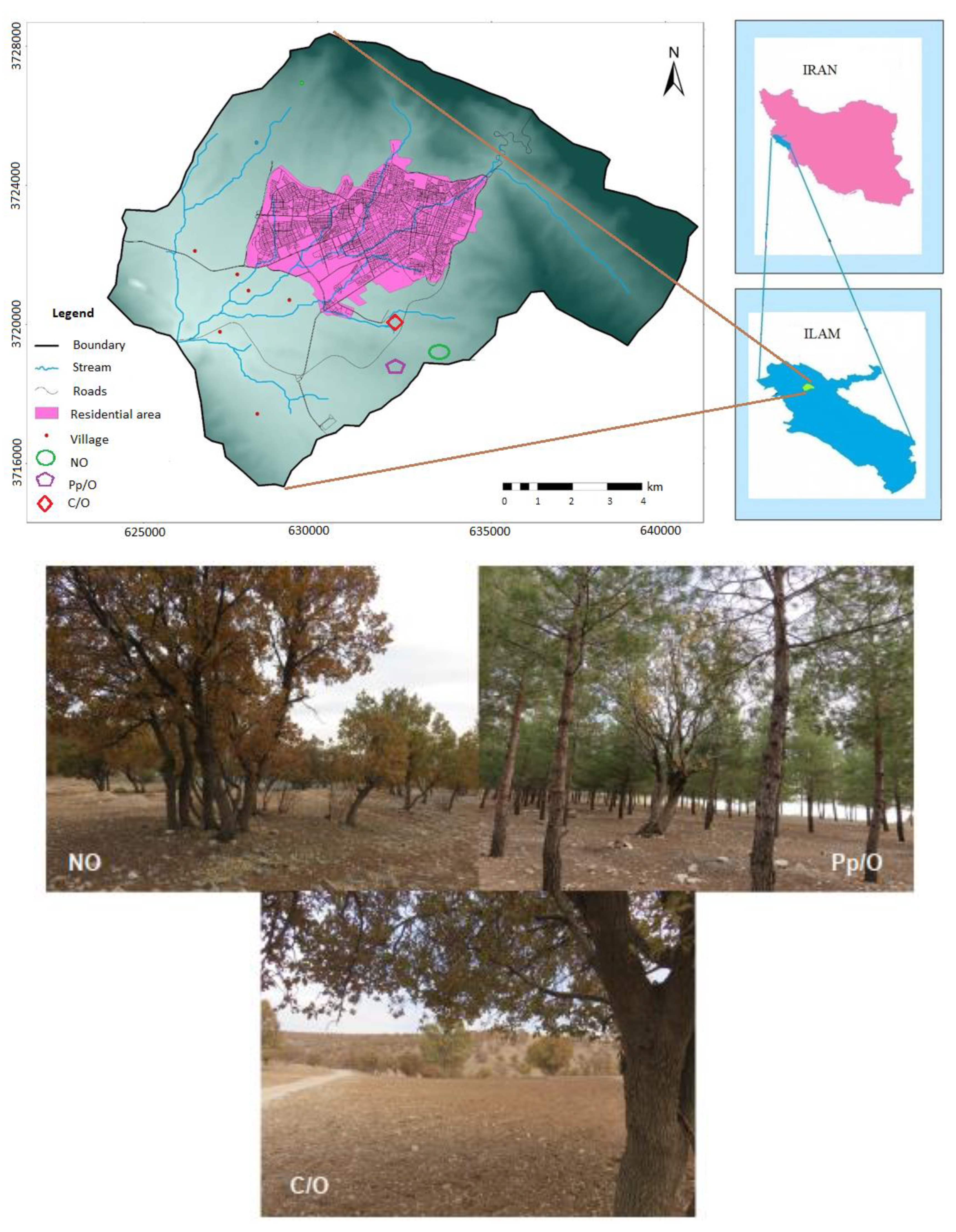
2.1. Study Area

The catchment of Ilam City covers 119 km2 in the north-east of the Ilam province (Iran) in the Zagros fold-thrust belt of this country (Figure 1). The study area (Choghasabz forest park, 33°39′ N to 33°40′ N, 46°28′ E to 46°30′ E) is located in the south-eastern part of the catchment. The mean annual precipitation and temperature are 591 ± 173 mm and 16.7 ± 0.7 °C (period of 1986–2021). The soil is classified as Inceptisol (Soil Survey Staff, 2014). Table 1 reports the main texture characteristics of the experimental soils. The study area is characterized by the same physiographic conditions (slope < 10% and mean elevation of about 1400 m a.s.l.).
The dominant species is Brant’s oak (Quercus brantii Lindl.) in coppice form with open canopy cover, and other woody species are Crataegus pontica K. Koch. and Daphne mucronata Royle, which sporadically occur in the understory. Soil erosion is one of the main threats of these forests, and this threat has been intensified by land use changes (cut down of woody species, cultivation of wheat under the forest floor and development of arable lands by deforestation) and fire occurrence (about once a year).
The study area was originally covered by the natural oak. This forest has been exploited by local people for hundred years to produce firewood and charcoal. Agriculture (mainly rain fed wheat cultivation) has been also practiced for decades. Consequently, various parts of the region have been completely or partially destroyed for agriculture and other needs. In the past, there was livestock grazing, but in the last two decades, livestock grazing licenses have not been issued in this area. The main cause of the destruction of the area is agriculture and plowing. To rehabilitate these degraded forests, the local authorities have planted mixed and pure forests with native and non-native tree species, such as Pinus eldarica Medw.

2.2. Experimental Design and Runoff Water and Sediments Measurements

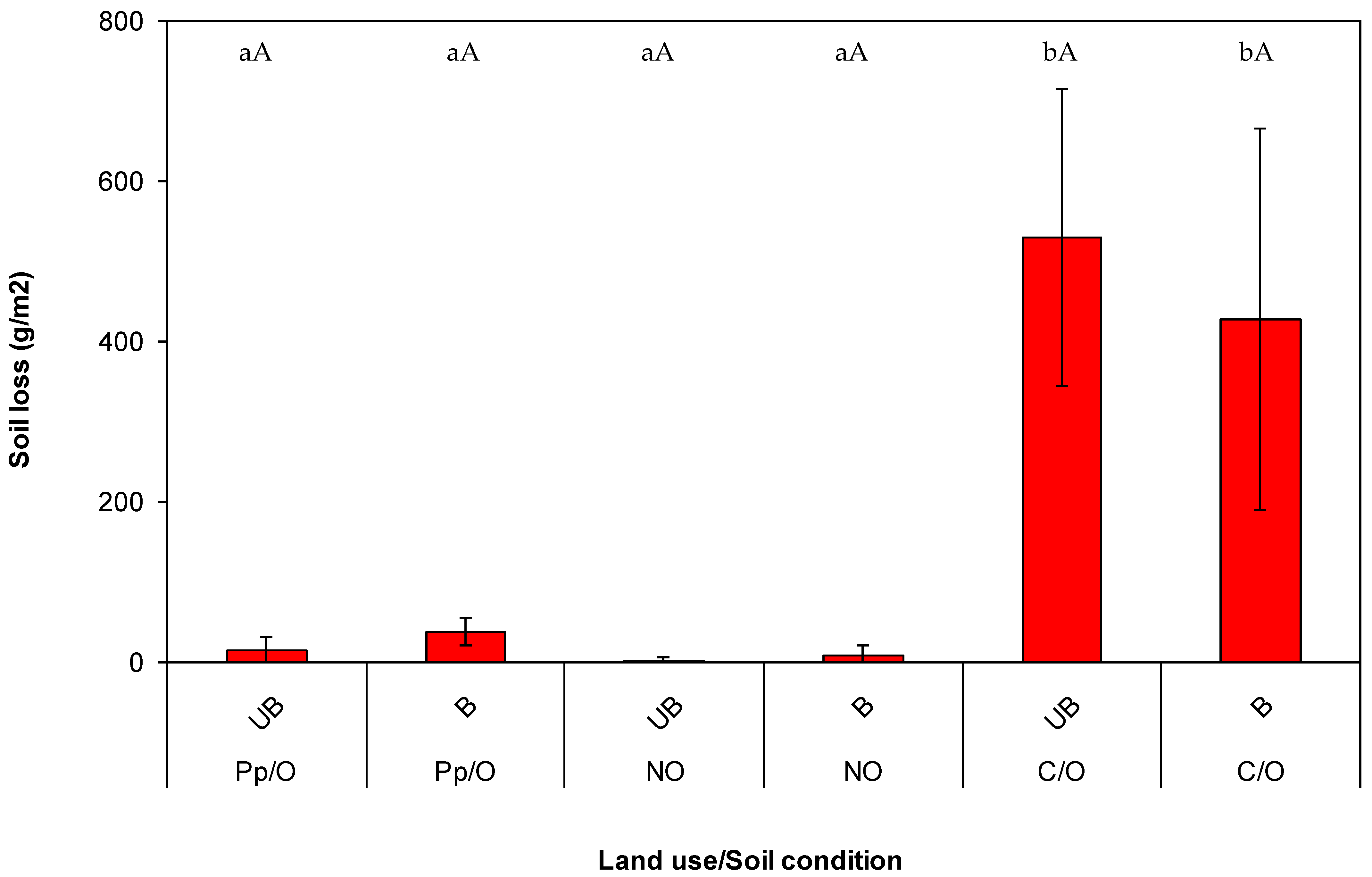
  • In the study area, three experimental sites (one for each land use) were selected: a natural stand of oak (hereafter indicated by “NO”), with trees having a mean diameter breast height (DBH) of 10 cm and litter with a mean depth of 4 cm;
  • A plantation of Pinus eldarica on an ancient oak forest (“Pp/O”) at a spacing of 4 × 5 m (trees with mean DBH of 12 cm and litter with mean depth of 1.50 cm);
  • An agro-forest stand, consisting of a cropland on the same ancient oak forest (“C/O”), which is a rainfed wheat farming, covered by debris and dry weeds.
These land uses were chosen considering the historical land-cover changes and land-use conversions for decades [35,36].

2.3. Runoff and Erosion Measurements

In each experimental site, two plots of about 1–3 hectares were identified under the same physiographic conditions and at less than 3 km from each other. The plots were setup in soils with different conditions (“unburned soil”, hereafter UB, and (“burned soil”, B) at a reciprocal distance lower than 3 m. The UB plot was left undisturbed and the B plot was subjected to an artificial wildfire simulation), applying fire by a gas flamethrower (Flame Gun Q_616). The flame, whose length was about 25 cm, was taken 20 cm from the soil surface. The flame was lighted in the surface litter and the fire was carried out until all the fuel was reduced to ash. Therefore, the experimental design consisted of three land uses (Pp/O, NO and C/O) × two plots with different soil conditions (UB and B).
In each plot, a rainfall was simulated in randomly selected small areas. Thirty-six simulations were carried out, six replications for each combination of land use and soil condition. An Eijelkamp® portable simulator was used [32,37], and the rainfall simulation was carried out following the methods developed by [38,39]. To summarize, the simulator was gently placed over the ground, caring that the vegetation was not disturbed by this operation. A rainfall with intensity of 10 mm/min was simulated over a surface area of 0.20 m × 0.20 m from a falling height of 40 cm. This rainfall intensity is typical of an extreme event for the study area (return interval over 50–100 year). The water volume in the sprinkler tank (about 1.2 L) was dosed by varying the pressure head, as suggested in the operating manual. After each rainfall simulation (180 s), the runoff water and sediments were collected in a small graduated bucket and then measured. The mean infiltration rate was calculated as the difference between the rainfall height and runoff divided by the duration.
Three soil samples from 0–30 cm depth were randomly collected from each site to determine soil texture using the hydrometric method (Bouyoucos, 1962).

2.4. Statistical Analysis
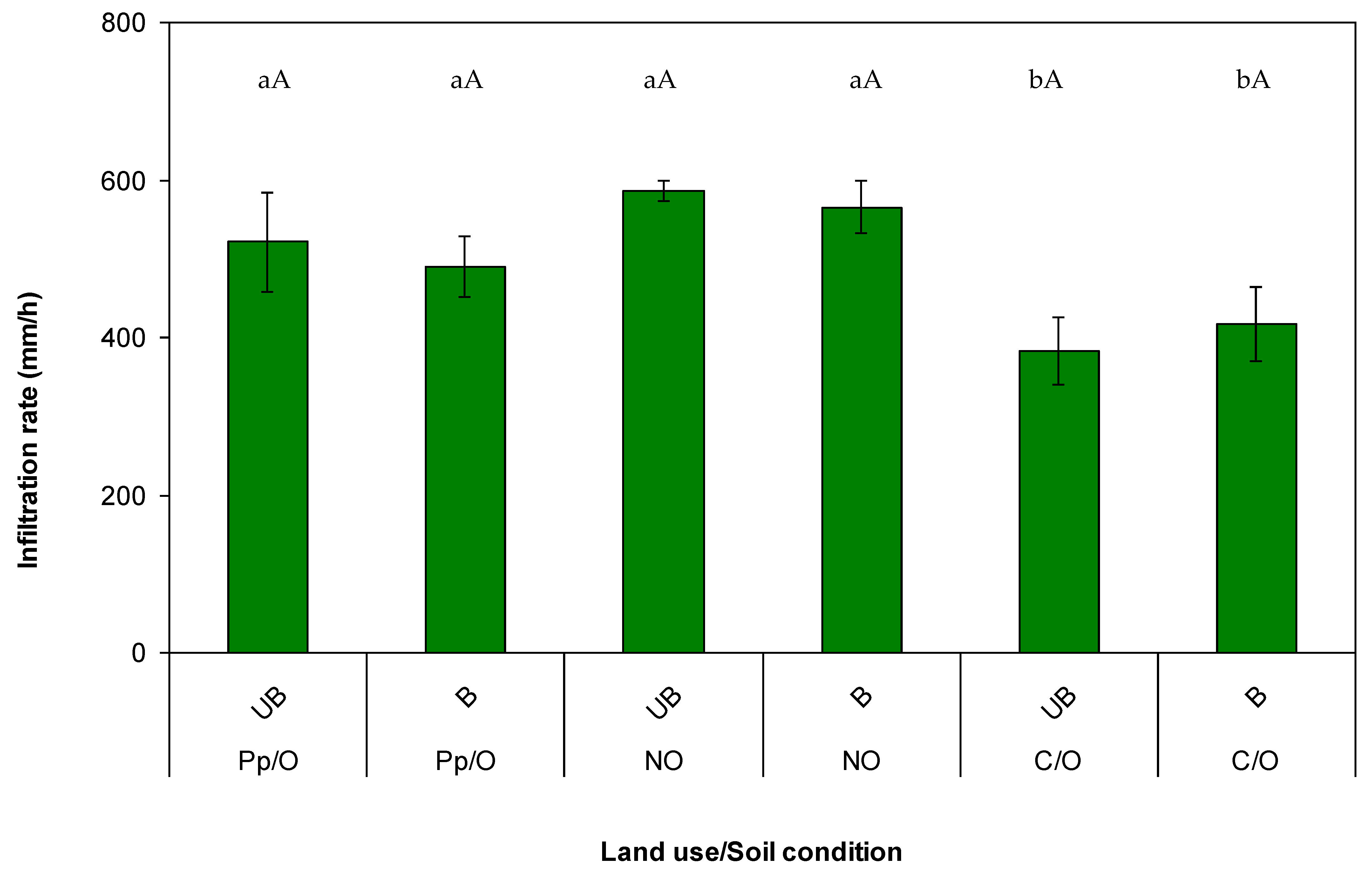
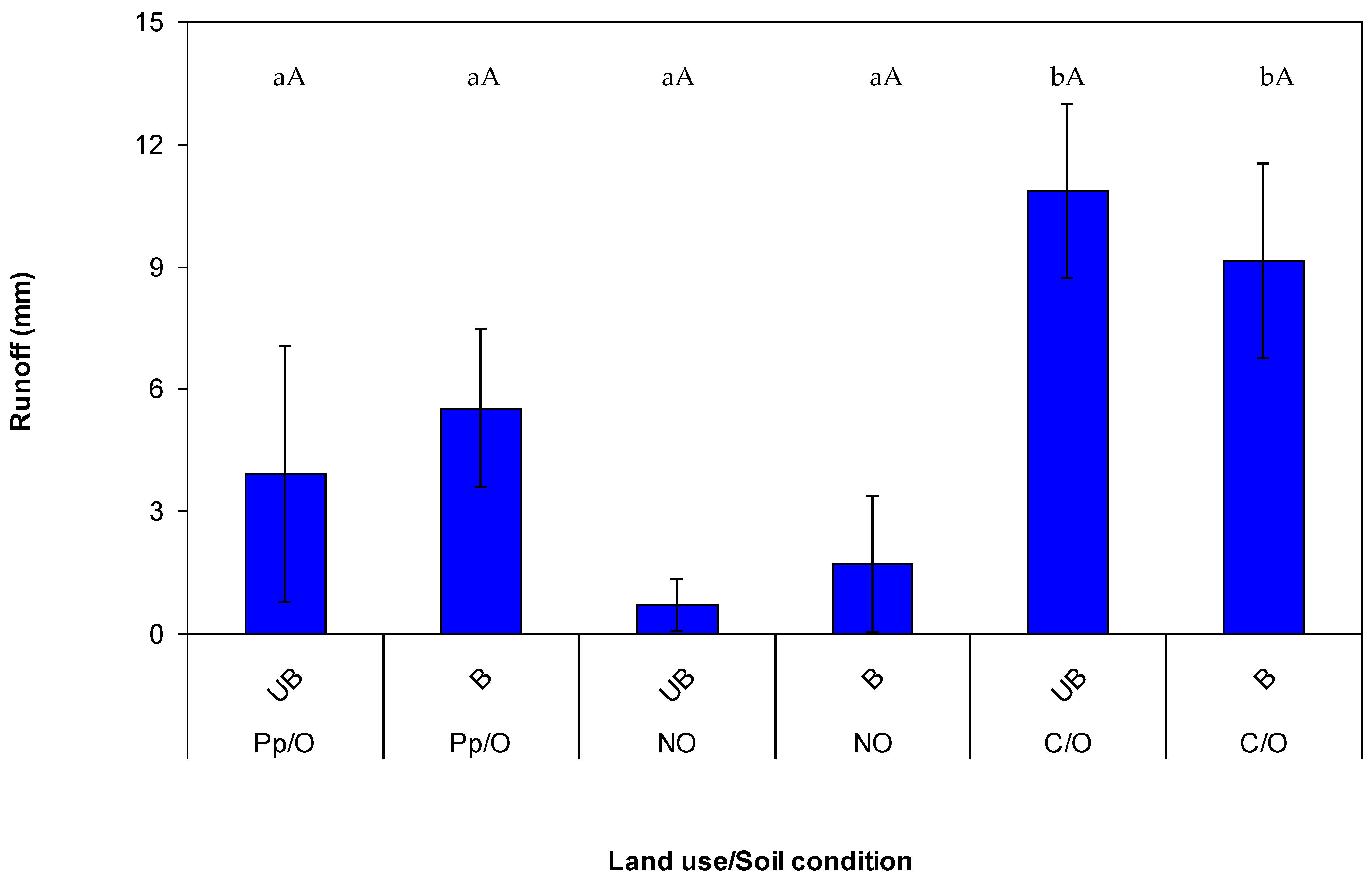
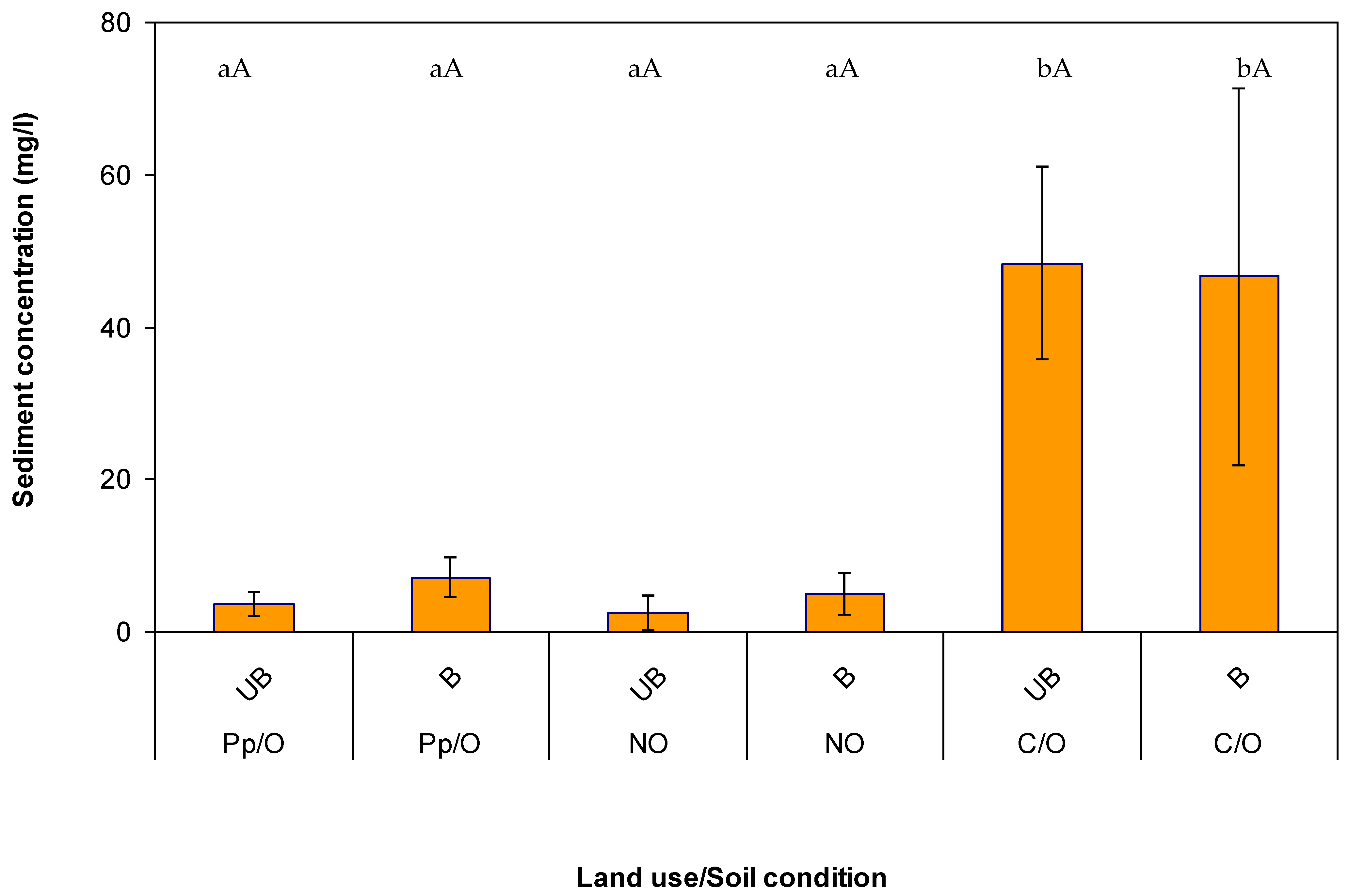
The statistical significance of the differences among land uses and soil conditions, and their interactions, was calculated using a 2-way ANOVA for surface runoff and soil loss. The latter were considered as dependent variables, while the land use and soil conditions were the independent factors. The pairwise comparison by Tukey’s test (at p < 0.05) was also used to evaluate the statistical significance of the differences in the two hydrological variables among factors. In order to satisfy the assumptions of the statistical tests (equality of variance and normal distribution), the data were subjected to a normality test or were square root-transformed whenever necessary. The statistical analysis was carried out using the XLSTAT software (release 2019, Addinsoft, Paris, France). Finally, mathematical correlations were found between couples of hydrological variables (runoff vs. sediment concentration vs. soil loss) for each soil condition.

3. Results

In the unburned sites, the mean infiltration rate was higher in the forests of pine and oak (521 ± 62.9 and 586 ± 12.5 mm/h, respectively) compared to the cropland (383 ± 42.6 mm/h). However, the mean infiltration rates in burned sites were decreased to 490 ± 38.7 mm/h (pine) and 565 ± 33.5 mm/h (oak) after the simulated rainfall in these forests, while the infiltration was increased to 417 ± 47.7 mm/h in the cropland (Figure 2).
Among the unburned sites, the cropland produced the highest runoff (10.9 ± 2.13 mm), while the oak forest gave the lowest volume (0.70 ± 0.63 mm). In the pine forest, an intermediate production of runoff was measured (3.64 ± 3.14 mm). Contrarily, in burned sites, the runoff decreased in the cropland (9.16 ± 2.38 mm), and increased in both of the pine and oak forests (5.53 ± 1.94 mm, pine, and 1.73 ± 1.67 mm, oak) (Figure 3). The ANOVA showed that only the differences among the land uses was significant (p < 0.05), while the influence of the soil condition and its interaction with the land use was found not significant (Table 2).
The highest sediment concentration among the unburned sites was measured in the cropland (48.4 ± 12.6 mg/L), while the lowest value was observed in the oak forest (2.61 ± 2.27 mg/L) and the pine plantation showing an intermediate concentration (3.71 ± 1.62 mg/L). On the other hand, the sediment concentration values in the land uses increased in both of the forests (7.07 ± 2.61 mg/L, pine, and 5.03 ± 2.28 mg/L, oak), and decreased in the cropland (46.7 ± 24.7 mg/L) in burned soil condition (Figure 4).
Moreover, under unburned conditions, soil erosion decreased in the following gradient of cropland (529 ± 182 g/m2) > pine forest (14.7 ± 16.3 g/m2) > oak forest (2.98 ± 2.97 g/m2). Increased soil loss was detected after the incidence of fire in the sites of both pine and oak forests with the values of 37.7 ± 17.2 and 9.38 ± 12.6 g/m2 respectively), while a decrease in values (427 ± 238 g/m2) was observed in the cropland (Figure 5). It was revealed from the ANOVA that only the land use (therefore not the soil condition) played a significant (p < 0.05) role on the soil loss (Table 2).
The correlations between the surface runoff and sediment concentration were found significant (p < 0.05). The linear correlation was found stronger (r2 = 0.71) for unburned soils, while it was weaker (r2 = 0.38) for the burned soil conditions. The soil loss was also revealed linearly correlated to the sediment concentration, as denoted by the highly significant coefficient of determination (r2 > 0.90). Finally, an exponential trend between the soil loss and runoff was found, whereas, the value of r2 was observed 0.64 soil) and 0.82 for the (burned and unburned sites respectively (Figure 6).

4. Discussion

The study revealed that regardless of the soil conditions, the infiltration rates were highly variable among the sites of different land uses (forestlands and cropland). The mean infiltrability of the forest sites was found higher by 25% compared to the agricultural land uses. The similar studies conducted in the semi-arid conditions demonstrated that croplands exhibit lower infiltrations compared to forestlands (e.g., [40,41,42]). This lower infiltration is presumably due to the mechanical tillage and other agricultural practices carried out in the crop fields that decrease the soil aggregate stability and therefore the macro-porosity [43,44]. Moreover, the presence of a well-developed tree and shrub covers increases the organic matter content of forest soils. It is well known that the organic matter increases the soil’s microporosity and aggregate stability, which create a preferential pattern for water infiltration (e.g., [45]).
In contrast, the differences in infiltration between soil conditions were lower than those detected for land uses and the variations in infiltration were not significant (maximum variability equal to 9%). The very similar infiltrability measured in this study in both burned and unburned soil conditions is surprising, since a large body of literature has demonstrated the decrease in soil hydraulic conductivity in burned sites due to fire effects [7,46,47]. In general, wildfire modifies the physico-chemical properties of the soil surface, and this also affects the hydrological response to precipitation [10,46]. The resulting wildfire impacts in burned areas are sealing, surface crust formation, pore clogging, and increase in bulk density [48]. Furthermore, the organic matter and macro-nutrients of soil largely decrease, and the soil structure is altered by the wildfire [9]. Finally, wildfire reduces aggregate stability and increases the water repellency of soils [13]. A possible explanation of the limited effect of wildfire on infiltration may be the presence of ash on burned soils, which determines a hydrophilic effect on soils. This effect may have balanced the decreased infiltration, due to the expected reduction in aggregate stability and increase in the water repellency of soil. As a matter of fact, ash can increase the water retention and reduce the repellency of soils [10,49], acting as a mulch with a wettable cover for soil, retaining rainwater and improving infiltration [50]. Considering that these effects have not been evidenced by this investigation, more investigation is required about the effects of wildfire on soil physical properties that govern water infiltration (e.g., aggregate stability, porosity, repellency) [2,42]. Some of these soil physical properties were not measured in this study, since the attention was paid to the soil’s hydrological effects of burning and vegetation removal rather than to their causes. Another limitation of this study is the lack of measurements of soil water repellency, which is expected to increase after high-severity fires and may be another reason of the variability of infiltration in the experimental sites [11,17,51].
In spite of the limited variability of infiltration, the hydrological response was found significantly different among the studied soil conditions and land uses. The surface runoff in the cropland was the highest among the three land uses (about 2.5-fold of the forest sites) and, within the forestlands, the oak soil produced lower runoff (−64%) compared to the pine. It was revealed from the experiment that the runoff increases when water infiltration decreases and vice versa in different land uses and soil condition. The higher runoff generation in croplands compared to forest areas is somewhat expected, since infiltration is generally lower, with more water turning to surface flow (e.g., [52]). In our experimental conditions, the amount of the variations in runoff generation is determined by the effects of other water losses, such as the interception and the evapo-transpiration. The vegetation cover is less developed in cultivated lands compared to forest areas, which increases the rainwater input to soil and therefore the runoff generation.
According to the variations detected for infiltration, the fire determined an increased runoff in the forest lands (+150% in the oak site and +40% in the pine forest), and a slight decrease in the cropland (−16%). The changes in soil properties due to wildfire determine noticeable impacts on post-fire hydrology, such as reduction in water infiltration or shifts in runoff generation mechanisms [10,48,49]. The fire removes the vegetation and changes some important soil properties (such as hydraulic conductivity, repellency level, contents of soil organic matter, minerals and macro-nutrients [7,12,13]). All these changes depend on fire temperature and duration as well as on precipitation patterns [2,4,5]. The absence of vegetation in burned sites made the soil susceptible to raindrop impact and sediment entrainment by overland flow [13]. In our experiments, the significant reduction of infiltration in the forest lands was detected in burned plots and it was mainly due to the removal of vegetation from soil, and the lower infiltration (indirectly estimated from surface runoff in this study) compared to the unburned soil conditions. In contrast, [3] reported decreases in runoff in burned range lands dominated by sagebrush compared to unburned plots, presumably due to the relatively higher infiltration determined by fire.
The same trends as of the infiltration and surface runoff were detected for the erosion. In more detail, the soil loss was much higher in the cropland (on an average 30-fold compared to the values measured in the forest lands), while the erosion in the pine plantation was three-fold to that of oak forest. The reason of these high differences in the soil loss among the investigated land uses can be due to the high sediment concentration measured in the cropland, which is much higher than in the forest lands. This explanation has been justified with the derived significant correlation between the soil loss and sediment concentration in our study. It is well known that the agricultural soils are subject to tillage and other cultivation operations, which commonly alter the physical properties (e.g., [45]). These operations break down the soil aggregate stability, which makes the croplands more prone to rainsplash detachment and sediment transport due to the overland flow [38,42].
The results also indicate high sediment detachment rates due to the rainsplash erosion in the croplands, and this agrees with many other studies comparing erosion betweeen agricultural and forest sites. For instance, ref. [53] found a significantly lower sediment detachment capacity in woodlands and forestlands of Northern Iran comparing to croplands and grasslands. Refs. [54,55,56] reported a higher soil erodibility in croplands of the Loess Plateau (China) that is two to 45 times greater than the other land uses.
In our study, the erosion in the burned forest sites was higher compared to the unburned sites by about 60%, while the soil loss in burned croplands was slightly (−20%) lower compared to the unburned plots. This increased soil loss in unburned croplands was again due to the differences in the mean sediment concentration between burned and unburned conditions (50%) rather than to the runoff variability (35%). The higher sediment concentration in the burned soils, which is typical of wildfire-affected areas, where sediment detachment and therefore erosion are enhanced, is presumably due to the decrease in aggregate stability (in turn linked to the depletion in the soil organic matter) [4,7,17]. Moreover, also the reduced vegetation cover may have left the soil exposed to rainfall erosivity with subsequent increased erosion rates in wildfire-affected areas [9]. The decrease in erosion in burned and cultivated sites (croplands) compared to the unburned sites is not expected at a first sight, but it can be explained by the decrease in the surface runoff detected between the two soil conditions (−16%). The effect of the rainsplash erosion was comparable between the two soil conditions, and therefore no significant increase in this erosion was evident.
The precipitation simulated in this study can be considered as an extremely erosive event with return interval of many years. In the forest lands, the mean soil loss is between 0.03 ± 0.03 tons/ha (unburned soil of pine) and 0.38 ± 0.17 tons/ha (burned soil of pine), and these erosion values are well below the tolerance limit for agricultural sites (about 10–12 tons/ha-year) [57,58]. In contrast, the soil erosion in the investigated croplands (about 4.5 tons/ha for only one rainfall event) is noticeable, and may be of concern when soil losses from more than two-three very intense events cumulate throughout a year. This is even more alarming for two reasons: first, the portable rainfall simulators underestimate rainsplash erosion, since the kinetic energy of the simulated precipitation is lower compared to a natural rainfall with an equal intensity; second, the effects of the runoff detachment in rills or gullies and sediment connectivity at a larger scale are not evaluated by small devices [59,60]. Therefore, this investigation suggests the implementation of anti-erosive actions in croplands especially in steeper soil profiles that should be targeted to the control of these soil losses, in order to avoid severe on-site and off-site effects. Wildfire increases hydrological response in wildfire-affected areas, especially during the so-called “window-of-disturbance” [61], when the runoff and erosion rates increase compared the unburned areas due to the fire effects [62,63]. After this period (which lasts from few months to several years, depending on fire intensity), the background conditions—that are typical of the soil hydrology before fire—restore over time, thanks to the vegetation regrowth and restoration of pre-fire properties of soils [64,65]. The duration of the windows of disturbance may be a measure of soil’s resilience to fire, since the shorter is the window, the higher is the forest capacity to recover its pre-fire conditions. The post-fire management actions must be implemented immediately after the wildfire, when the soils is left bare and lacks the vegetation cover as well as the entity of the fire-induced changes in soil properties is the highest over time [66]. Some of these actions are afforestation, seeding, mulching, salvage logging, erosion barriers—the latter including log erosion barriers or contour felled log debris—or soil preparation [9].
Moreover, the correlation analysis has shown that the erosion may exponentially increase with the runoff. The rainfall simulation experiments are able to estimate rainsplash erosion, and do not consider soil detachment by overland flow and thus rill and inter-rill erosion. This may lead us to assume that the erosion occurring at hillslope or catchment scale may be even higher than the soil losses measured in croplands, and this enables the adoption of erosion mitigation strategies as an essential task for land managers.

5. Conclusions

This study has evaluated water infiltration, surface runoff and soil losses after simulated rainfall in two pine and oak forests, and a cropland in Zagros Mountain.
The difference in infiltration between burned and unburned plots under the three land uses was not significant, and the burned cropland was characterised by a higher infiltrability compared to the forest sites.
The simulated fire noticeably increased the runoff and erosion in forest land and slightly decreased it in the cropland. The working hypothesis is that the simulated wildfire plays a key role in governing the hydrological responses and it should be rejected in the cropland and accepted in the forestlands. The decrease in runoff and erosion detected in the burned cropland may be due to the fire simulation, which was unsuitable to reproduce the effects of a wildfire on soil hydraulic properties.
Much caution should be paid to erosion in croplands, since the soil loss may be on an average 30-fold compared to the values measured in the forestland and the higher sediment detachment rates due to rainsplash erosion. In our study (i) the erosion rates are not far from the tolerance limit for agricultural sites, (ii) the rainsplash erosion may be underestimated, and (iii) the rill or gully erosion is not considered and thus the study suggests the adoption of anti-erosive strategies in croplands of the Zagros forests.
Overall, this study has provided an insight in improving our existing knowledge in soil hydrology under different land uses and soil conditions, which helps the tasks of land managers and authorities towards the restoration and rehabilitation of delicate environments after wildfire and hydrogeological hazards. Further research should go beyond some limitation of this study, such as the wildfire simulation, and the hydrological measurements under a small scale spatial and artificial precipitation, by field experiments at plot or hillslope scales after real wildfires and natural precipitation. Finally, the role of some essential hydrogeological processes, such as the soil hydrophobicity, and changes in key physical properties of soils must be explored to better understand the variability of the hydrological processes under the given land uses and soil conditions.

Author Contributions

Conceptualization, N.R. and M.H.; methodology, N.R. and M.H.; validation, N.R., M.H., S.M.M.U., M.E.L.-B. and D.A.Z.; formal analysis, N.R., M.H., S.M.M.U., M.E.L.-B. and D.A.Z.; investigation, N.R., M.H., S.M.M.U., M.E.L.-B. and D.A.Z.; data curation, N.R., M.H., S.M.M.U., M.E.L.-B. and D.A.Z.; writing—original draft preparation, N.R., M.H., M.E.L.-B. and D.A.Z.; writing—review and editing, N.R., M.H., M.E.L.-B. and D.A.Z.; supervision, N.R. and M.H.; project administration, N.R. and M.H.; funding acquisition, N.R. and M.H. All authors have read and agreed to the published version of the manuscript.

Funding

This research received no external funding.

Institutional Review Board Statement

Not applicable.

Informed Consent Statement

Not applicable.

Data Availability Statement

The data presented in this study are available on request from the corresponding author.

Acknowledgments

We are grateful to Ilam University for financial support of the research.

Conflicts of Interest

The authors declare no conflict of interest.

References

  1. Heydari, M.; Moradizadeh, H.; Omidipour, R.; Mezbani, A.; Pothier, D. Spatio-temporal Changes in the Understory Heterogeneity, Diversity, and Composition after Fires of Different Severities in a Semiarid Oak (Quercus Brantii Lindl.) Forest. Land Degrad. Dev. 2020, 31, 1039–1049. [Google Scholar] [CrossRef]
  2. Pereira, P.; Francos, M.; Brevik, E.C.; Ubeda, X.; Bogunovic, I. Post-Fire Soil Management. Curr. Opin. Environ. Sci. Health 2018, 5, 26–32. [Google Scholar] [CrossRef]
  3. Pierson, F.B.; Robichaud, P.R.; Spaeth, K.E. Spatial and Temporal Effects of Wildfire on the Hydrology of a Steep Rangeland Watershed. Hydrol. Process. 2001, 15, 2905–2916. [Google Scholar] [CrossRef]
  4. Moody, J.A.; Shakesby, R.A.; Robichaud, P.R.; Cannon, S.H.; Martin, D.A. Current Research Issues Related to Post-Wildfire Runoff and Erosion Processes. Earth-Sci. Rev. 2013, 122, 10–37. [Google Scholar] [CrossRef]
  5. Shakesby, R.A. Post-Wildfire Soil Erosion in the Mediterranean: Review and Future Research Directions. Earth-Sci. Rev. 2011, 105, 71–100. [Google Scholar] [CrossRef]
  6. Heydari, M.; Omidipour, R.; Abedi, M.; Baskin, C. Effects of Fire Disturbance on Alpha and Beta Diversity and on Beta Diversity Components of Soil Seed Banks and Aboveground Vegetation. Plant Ecol. Evol. 2017, 150, 247–256. [Google Scholar] [CrossRef]
  7. Zavala, L.M.; De Celis, R.; Jordán, A. How Wildfires Affect Soil Properties. A Brief Review. Cuad. Investig. Geográfica 2014, 40, 311. [Google Scholar] [CrossRef] [Green Version]
  8. Glenn, N.F.; Finley, C.D. Fire and Vegetation Type Effects on Soil Hydrophobicity and Infiltration in the Sagebrush-Steppe: I. Field Analysis. J. Arid Environ. 2010, 74, 653–659. [Google Scholar] [CrossRef]
  9. Zema, D.A. Postfire Management Impacts on Soil Hydrology. Curr. Opin. Environ. Sci. Health 2021, 21, 100252. [Google Scholar] [CrossRef]
  10. Inbar, A.; Lado, M.; Sternberg, M.; Tenau, H.; Ben-Hur, M. Forest Fire Effects on Soil Chemical and Physicochemical Properties, Infiltration, Runoff, and Erosion in a Semiarid Mediterranean Region. Geoderma 2014, 221–222, 131–138. [Google Scholar] [CrossRef]
  11. DeBano, L.F. Water Repellent Soils: A State-of-the-Art; US Department of Agriculture, USDA Forest Service, Pacific Southwest Region: Vallejo, CA, USA, 1981; Volume 46. [Google Scholar]
  12. Alcañiz, M.; Outeiro, L.; Francos, M.; Úbeda, X. Effects of Prescribed Fires on Soil Properties: A Review. Sci. Total Environ. 2018, 613, 944–957. [Google Scholar] [CrossRef]
  13. Shakesby, R.; Doerr, S. Wildfire as a Hydrological and Geomorphological Agent. Earth-Sci. Rev. 2006, 74, 269–307. [Google Scholar] [CrossRef]
  14. Robichaud, P.R.; Waldrop, T.A. A comparison of surface runoff and sediment yields from low-and high-severity site preparation burns 1. JAWRA J. Am. Water Resour. Assoc. 1994, 30, 27–34. [Google Scholar] [CrossRef]
  15. Zema, D.A.; Nunes, J.P.; Lucas-Borja, M.E. Improvement of Seasonal Runoff and Soil Loss Predictions by the MMF (Morgan-Morgan-Finney) Model after Wildfire and Soil Treatment in Mediterranean Forest Ecosystems. Catena 2020, 188, 104415. [Google Scholar] [CrossRef]
  16. Zema, D.A.; Plaza-Alvarez, P.A.; Xu, X.; Carra, B.G.; Lucas-Borja, M.E. Influence of Forest Stand Age on Soil Water Repellency and Hydraulic Conductivity in the Mediterranean Environment. Sci. Total Environ. 2021, 753, 142006. [Google Scholar] [CrossRef]
  17. Cawson, J.G.; Sheridan, G.J.; Smith, H.G.; Lane, P.N.J. Surface Runoff and Erosion after Prescribed Burning and the Effect of Different Fire Regimes in Forests and Shrublands: A Review. Int. J. Wildland Fire 2012, 21, 857. [Google Scholar] [CrossRef]
  18. Lucas-Borja, M.E.; Bombino, G.; Carrà, B.G.; D’Agostino, D.; Denisi, P.; Labate, A.; Plaza-Alvarez, P.A.; Zema, D.A. Modeling the Soil Response to Rainstorms after Wildfire and Prescribed Fire in Mediterranean Forests. Climate 2020, 8, 150. [Google Scholar] [CrossRef]
  19. Prats, S.; Abrantes, J.; Crema, I.P.; Keizer, J.J.; Pedroso de Lima, J. Testing the Effectiveness of Three Forest Residue Mulch Application Schemes for Reducing Post-Fire Runoff and Soil Erosion Using Indoor Simulated Rain. Flamma 2015, 6, 113–116. [Google Scholar]
  20. Lopes, A.R.; Girona-García, A.; Corticeiro, S.; Martins, R.; Keizer, J.J.; Vieira, D.C.S. What Is Wrong with Post-fire Soil Erosion Modelling? A Meta-analysis on Current Approaches, Research Gaps, and Future Directions. Earth Surf. Process. Landf. 2021, 46, 205–219. [Google Scholar] [CrossRef]
  21. Benavides-Solorio, J.; MacDonald, L.H. Post-fire Runoff and Erosion from Simulated Rainfall on Small Plots, Colorado Front Range. Hydrol. Process. 2001, 15, 2931–2952. [Google Scholar] [CrossRef]
  22. Sheridan, G.J.; Lane, P.N.; Noske, P.J. Quantification of Hillslope Runoff and Erosion Processes before and after Wildfire in a Wet Eucalyptus Forest. J. Hydrol. 2007, 343, 12–28. [Google Scholar] [CrossRef]
  23. Hosseini, M.; Keizer, J.J.; Pelayo, O.G.; Prats, S.A.; Ritsema, C.; Geissen, V. Effect of Fire Frequency on Runoff, Soil Erosion, and Loss of Organic Matter at the Micro-Plot Scale in North-Central Portugal. Geoderma 2016, 269, 126–137. [Google Scholar] [CrossRef]
  24. Inbar, M.; Tamir, M.I.; Wittenberg, L. Runoff and Erosion Processes after a Forest Fire in Mount Carmel, a Mediterranean Area. Geomorphology 1998, 24, 17–33. [Google Scholar] [CrossRef]
  25. Vieira, D.C.S.; Serpa, D.; Nunes, J.P.C.; Prats, S.A.; Neves, R.; Keizer, J.J. Predicting the Effectiveness of Different Mulching Techniques in Reducing Post-Fire Runoff and Erosion at Plot Scale with the RUSLE, MMF and PESERA Models. Environ. Res. 2018, 165, 365–378. [Google Scholar] [CrossRef]
  26. Zema, D.A.; Lucas-Borja, M.E.; Fotia, L.; Rosaci, D.; Sarnè, G.M.; Zimbone, S.M. Predicting the Hydrological Response of a Forest after Wildfire and Soil Treatments Using an Artificial Neural Network. Comput. Electron. Agric. 2020, 170, 105280. [Google Scholar] [CrossRef]
  27. Nunes, J.P.; Naranjo Quintanilla, P.; Santos, J.M.; Serpa, D.; Carvalho-Santos, C.; Rocha, J.; Keizer, J.J.; Keesstra, S.D. Afforestation, Subsequent Forest Fires and Provision of Hydrological Services: A Model-Based Analysis for a Mediterranean Mountainous Catchment: Mediterranean Afforestation, Forest Fires and Hydrological Services. Land Degrad. Dev. 2018, 29, 776–788. [Google Scholar] [CrossRef]
  28. Aksoy, H.; Kavvas, M.L. A Review of Hillslope and Watershed Scale Erosion and Sediment Transport Models. Catena 2005, 64, 247–271. [Google Scholar] [CrossRef]
  29. Merritt, W.S.; Letcher, R.A.; Jakeman, A.J. A Review of Erosion and Sediment Transport Models. Environ. Model. Softw. 2003, 18, 761–799. [Google Scholar] [CrossRef]
  30. Douglas, I. Hydrological Investigations of Forest Disturbance and Land Cover Impacts in South–East Asia: A Review. Philos. Trans. R. Soc. Lond. Ser. B Biol. Sci. 1999, 354, 1725–1738. [Google Scholar] [CrossRef] [Green Version]
  31. Mohajerani, H.; Zema, D.A.; Lucas-Borja, M.E.; Casper, M. Understanding the Water Balance and Its Estimation Methods. In Precipitation; Elsevier: Amsterdam, The Netherlands, 2021; pp. 193–221. [Google Scholar]
  32. Iserloh, T.; Ries, J.B.; Arnáez, J.; Boix-Fayos, C.; Butzen, V.; Cerdà, A.; Echeverría, M.T.; Fernández-Gálvez, J.; Fister, W.; Geißler, C. European Small Portable Rainfall Simulators: A Comparison of Rainfall Characteristics. Catena 2013, 110, 100–112. [Google Scholar] [CrossRef] [Green Version]
  33. Heydari-Guran, S.; Ghasidian, E. Late Pleistocene Hominin Settlement Patterns and Population Dynamics in the Zagros Mountains: Kermanshah Region. Archaeol. Res. Asia 2020, 21, 100161. [Google Scholar] [CrossRef]
  34. Yusefi, G.H.; Faizolahi, K.; Darvish, J.; Safi, K.; Brito, J.C. The Species Diversity, Distribution, and Conservation Status of the Terrestrial Mammals of Iran. J. Mammal. 2019, 100, 55–71. [Google Scholar] [CrossRef]
  35. Heydari, M.; Poorbabaei, H.; Bazgir, M.; Salehi, A.; Eshaghirad, J. Earthworms as Indicators for Different Forest Management Types and Human Disturbance in Ilam Oak Forest, Iran. Folia For. Pol. Ser. A For. 2014, 56, 121–134. [Google Scholar] [CrossRef] [Green Version]
  36. Samani, K.M.; Pordel, N.; Hosseini, V.; Shakeri, Z. Effect of Land-Use Changes on Chemical and Physical Properties of Soil in Western Iran (Zagros Oak Forests). J. For. Res. 2020, 31, 637–647. [Google Scholar] [CrossRef]
  37. Hlavčová, K.; Danáčová, M.; Kohnová, S.; Szolgay, J.; Valent, P.; Výleta, R. Estimating the Effectiveness of Crop Management on Reducing Flood Risk and Sediment Transport on Hilly Agricultural Land—A Myjava Case Study, Slovakia. CATENA 2019, 172, 678–690. [Google Scholar] [CrossRef]
  38. Bombino, G.; Denisi, P.; Gómez, J.; Zema, D. Water Infiltration and Surface Runoff in Steep Clayey Soils of Olive Groves under Different Management Practices. Water 2019, 11, 240. [Google Scholar] [CrossRef] [Green Version]
  39. Carrà, B.G.; Bombino, G.; Denisi, P.; Plaza-Àlvarez, P.A.; Lucas-Borja, M.E.; Zema, D.A. Water Infiltration after Prescribed Fire and Soil Mulching with Fern in Mediterranean Forests. Hydrology 2021, 8, 95. [Google Scholar] [CrossRef]
  40. Cerdà, A.; Doerr, S.H. Soil Wettability, Runoff and Erodibility of Major Dry-Mediterranean Land Use Types on Calcareous Soils. Hydrol. Process. Int. J. 2007, 21, 2325–2336. [Google Scholar] [CrossRef]
  41. Dunjó, G.; Pardini, G.; Gispert, M. The Role of Land Use–Land Cover on Runoff Generation and Sediment Yield at a Microplot Scale, in a Small Mediterranean Catchment. J. Arid Environ. 2004, 57, 239–256. [Google Scholar] [CrossRef]
  42. Lucas-Borja, M.E.; Zema, D.A.; Plaza-Álvarez, P.A.; Zupanc, V.; Baartman, J.; Sagra, J.; González-Romero, J.; Moya, D.; de las Heras, J. Effects of Different Land Uses (Abandoned Farmland, Intensive Agriculture and Forest) on Soil Hydrological Properties in Southern Spain. Water 2019, 11, 503. [Google Scholar] [CrossRef] [Green Version]
  43. Messing, I.; Alriksson, A.; Johansson, W. Soil Physical Properties of Afforested and Arable Land. Soil Use Manag. 1997, 13, 209–217. [Google Scholar] [CrossRef]
  44. Pagliai, M.; Vignozzi, N.; Pellegrini, S. Soil Structure and the Effect of Management Practices. Soil Tillage Res. 2004, 79, 131–143. [Google Scholar] [CrossRef]
  45. Hillel, D. Environmental Soil Physics: Fundamentals, Applications, and Environmental Considerations; Elsevier: Amsterdam, The Netherlands, 1998; ISBN 0-08-054415-0. [Google Scholar]
  46. Certini, G. Effects of Fire on Properties of Forest Soils: A Review. Oecologia 2005, 143, 1–10. [Google Scholar] [CrossRef] [PubMed]
  47. Plaza-Álvarez, P.A.; Lucas-Borja, M.E.; Sagra, J.; Zema, D.A.; González-Romero, J.; Moya, D.; De las Heras, J. Changes in Soil Hydraulic Conductivity after Prescribed Fires in Mediterranean Pine Forests. J. Environ. Manag. 2019, 232, 1021–1027. [Google Scholar] [CrossRef]
  48. Niemeyer, R.J.; Bladon, K.D.; Woodsmith, R.D. Long-Term Hydrologic Recovery after Wildfire and Post-Fire Forest Management in the Interior Pacific Northwest. Hydrol. Process. 2020, 34, 1182–1197. [Google Scholar] [CrossRef]
  49. Wittenberg, L.; van der Wal, H.; Keesstra, S.; Tessler, N. Post-Fire Management Treatment Effects on Soil Properties and Burned Area Restoration in a Wildland-Urban Interface, Haifa Fire Case Study. Sci. Total Environ. 2020, 716, 135190. [Google Scholar] [CrossRef]
  50. Thomaz, E.L. Ash Physical Characteristics Affects Differently Soil Hydrology and Erosion Subprocesses. Land Degrad. Dev. 2018, 29, 690–700. [Google Scholar] [CrossRef]
  51. Doerr, S.H.; Ferreira, A.J.D.; Walsh, R.P.D.; Shakesby, R.A.; Leighton-Boyce, G.; Coelho, C.O.A. Soil Water Repellency as a Potential Parameter in Rainfall-runoff Modelling: Experimental Evidence at Point to Catchment Scales from Portugal. Hydrol. Process. 2003, 17, 363–377. [Google Scholar] [CrossRef]
  52. Zuazo, V.H.D.; Pleguezuelo, C.R.R. Soil-Erosion and Runoff Prevention by Plant Covers: A Review. Sustain. Agric. 2009, 785–811. [Google Scholar]
  53. Parhizkar, M.; Shabanpour, M.; Khaledian, M.; Cerdà, A.; Rose, C.W.; Asadi, H.; Lucas-Borja, M.E.; Zema, D.A. Assessing and Modeling Soil Detachment Capacity by Overland Flow in Forest and Woodland of Northern Iran. Forests 2020, 11, 65. [Google Scholar] [CrossRef] [Green Version]
  54. Li, Z.-W.; Zhang, G.-H.; Geng, R.; Wang, H.; Zhang, X.C. Land Use Impacts on Soil Detachment Capacity by Overland Flow in the Loess Plateau, China. Catena 2015, 124, 9–17. [Google Scholar] [CrossRef]
  55. Zhang, G.; Tang, M.; Zhang, X.C. Temporal Variation in Soil Detachment under Different Land Uses in the Loess Plateau of China. Earth Surf. Process. Landf. 2009, 34, 1302–1309. [Google Scholar] [CrossRef]
  56. Zhang, G.-H.; Liu, G.-B.; Tang, K.-M.; Zhang, X.-C. Flow Detachment of Soils under Different Land Uses in the Loess Plateau of China. Trans. ASABE 2008, 51, 883–890. [Google Scholar] [CrossRef]
  57. Bazzoffi, P. Soil Erosion Tolerance and Water Runoff Control: Minimum Environmental Standards. Reg. Environ. Chang. 2009, 9, 169–179. [Google Scholar] [CrossRef]
  58. Wischmeier, W.H. Predicting Rainfall Erosion Losses. In USDA Agricultural Research Services Handbook; USDA: Washington, DC, USA, 1978; Volume 537. [Google Scholar]
  59. Hamed, Y.; Albergel, J.; Pépin, Y.; Asseline, J.; Nasri, S.; Zante, P.; Berndtsson, R.; El-Niazy, M.; Balah, M. Comparison between Rainfall Simulator Erosion and Observed Reservoir Sedimentation in an Erosion-Sensitive Semiarid Catchment. Catena 2002, 50, 1–16. [Google Scholar] [CrossRef]
  60. Loch, R.J.; Robotham, B.G.; Zeller, L.; Masterman, N.; Orange, D.N.; Bridge, B.J.; Sheridan, G.; Bourke, J.J. A Multi-Purpose Rainfall Simulator for Field Infiltration and Erosion Studies. Earth Surf. Process. Landf. 2001, 39, 599–610. [Google Scholar] [CrossRef]
  61. Prosser, I.P.; Williams, L. The Effect of Wildfire on Runoff and Erosion in Native Eucalyptus Forest. Hydrol. Process. 1998, 12, 251–265. [Google Scholar] [CrossRef]
  62. Keizer, J.J.; Silva, F.C.; Vieira, D.C.S.; González-Pelayo, O.; Campos, I.; Vieira, A.M.D.; Valente, S.; Prats, S.A. The Effectiveness of Two Contrasting Mulch Application Rates to Reduce Post-Fire Erosion in a Portuguese Eucalypt Plantation. Catena 2018, 169, 21–30. [Google Scholar] [CrossRef]
  63. Wilson, C.; Kampf, S.K.; Wagenbrenner, J.W.; MacDonald, L.H. Rainfall Thresholds for Post-Fire Runoff and Sediment Delivery from Plot to Watershed Scales. For. Ecol. Manag. 2018, 430, 346–356. [Google Scholar] [CrossRef]
  64. Vieira, D.C.S.; Malvar, M.C.; Martins, M.A.S.; Serpa, D.; Keizer, J.J. Key Factors Controlling the Post-Fire Hydrological and Erosive Response at Micro-Plot Scale in a Recently Burned Mediterranean Forest. Geomorphology 2018, 319, 161–173. [Google Scholar] [CrossRef]
  65. Zituni, R.; Wittenberg, L.; Malkinson, D. The Effects of Post-Fire Forest Management on Soil Erosion Rates 3 and 4 Years after a Wildfire, Demonstrated on the 2010 Mount Carmel Fire. Int. J. Wildland Fire 2019, 28, 377–385. [Google Scholar] [CrossRef]
  66. Lucas-Borja, M.E. Efficiency of Post-Fire Hillslope Management Strategies: Gaps of Knowledge. Curr. Opin. Environ. Sci. Health 2021, 21, 100247. [Google Scholar] [CrossRef]
Figure 1. Geographical location, upper, and some photos of the study area (Zagros forest, Western Iran); notes: NO = natural stand of oak; Pp/O = pine plantation on ancient oak forest and C/O = cropland on ancient oak forest.
Forests 13 00246 g001
Figure 2. Soil infiltration rates measured using a rainfall simulator in different land uses (Pp /O = pine plantation on ancient oak forest; NO = natural stand of oak; C/O = cropland on ancient oak forest) and soil conditions (UB = unburned soil; B = burned soil) in the experimental area (Zagros forests, Western Iran). Different lowercase letters indicate significant differences among land uses, while different capital letters indicate significant differences between soil conditions, according to Tukey’s test (at p < 0.05).
Forests 13 00246 g002
Figure 3. Runoff volumes measured using a rainfall simulator in different land uses (Pp/O = pine plantation on ancient oak forest; NO = natural stand of oak; C/O = cropland on ancient oak forest) and soil conditions (UB = unburned soil; B = burned soil) in the experimental area (Zagros forests, Western Iran). Different lowercase letters indicate significant differences among land uses, while different capital letters indicate significant differences between soil conditions, according to Tukey’s test (at p < 0.05).
Forests 13 00246 g003
Figure 4. Sediment concentration measured using a rainfall simulator in different land uses (Pp/O = pine plantation on ancient oak forest; NO = natural stand of oak; C/O = cropland on ancient oak forest) and soil conditions (UB = unburned soil; B = burned soil) in the experimental area (Zagros forests, Western Iran). Different lowercase letters indicate significant differences among land uses, while different capital letters indicate significant differences between soil conditions, according to Tukey’s test (at p < 0.05).
Forests 13 00246 g004
Figure 5. Soil losses measured using a rainfall simulator in different land uses (Pp/O = pine plantation on ancient oak forest; NO = natural stand of oak; C/O = cropland on ancient oak forest) and soil conditions (UB = unburned soil; B = burned soil) in the experimental area (Zagros forests, Western Iran). Different lowercase letters indicate significant differences among land uses, while different capital letters indicate significant differences between soil conditions, according to Tukey’s test (at p < 0.05).
Forests 13 00246 g005
Figure 6. Correlations among the hydrological variables measured by the rainfall simulator under the two soil conditions and land uses in the experimental area (Zagros forests, Western Iran).
Forests 13 00246 g006aForests 13 00246 g006b
Table 1. Texture of the soil at different land uses in the experimental area (Zagros forest, Western Iran).
Land UseSoil Texture (% Content)
SandSiltClay
Pp/O59.0 ± 8.517.0 ± 5.324.0 ± 3.8
NO64.0 ± 19.320.5 ± 6.015.5 ± 4.2
C/O49.8 ± 5.018.5 ± 4.231.7 ± 2.0
Notes: NO = natural stand of oak; Pp/O = pine plantation on ancient oak forest; C/O = cropland on ancient oak forest.
Table 2. Results of two-way ANOVA to evaluate the statistical significance of the differences among land uses (pine plantation on ancient oak forest vs. natural stand of oak vs. cropland on ancient oak forest) and soil conditions (unburned, and burned), and their interactions in the experimental area (Zagros forests, Western Iran).
FactorDegrees of FreedomSum of SquaresMean SquaresFPr > F
Surface Runoff
Land use248324253.1240.000
Soil condition10.620.620.1370.714
Land use × Soil condition219.39.662.1250.137
Land use21,773,147886,57453.2540.000
Soil condition1633763370.3810.542
Land use × Soil condition229,09214,5460.8740.427
Publisher’s Note: MDPI stays neutral with regard to jurisdictional claims in published maps and institutional affiliations.

