Integration of TLS and HLS Data for Non-Destructive Structural Damage Assessment of Building Structures: A Case Study of a Small Hydropower Plant
Highlights
- TLS data alone was insufficient to capture the full geometry of damage zones.
- TLS and HLS IR data integrated to fill measurement gaps in dam structure.
- Both HLS modes yielded consistent crack widths with ≤0.37 mm difference.
- Integration fills TLS blind spots and increases diagnostic completeness.
- Precise geometry improves structural risk assessment and decision-making.
- The method supports early detection and monitoring in hydraulic infrastructure.
Abstract
1. Introduction
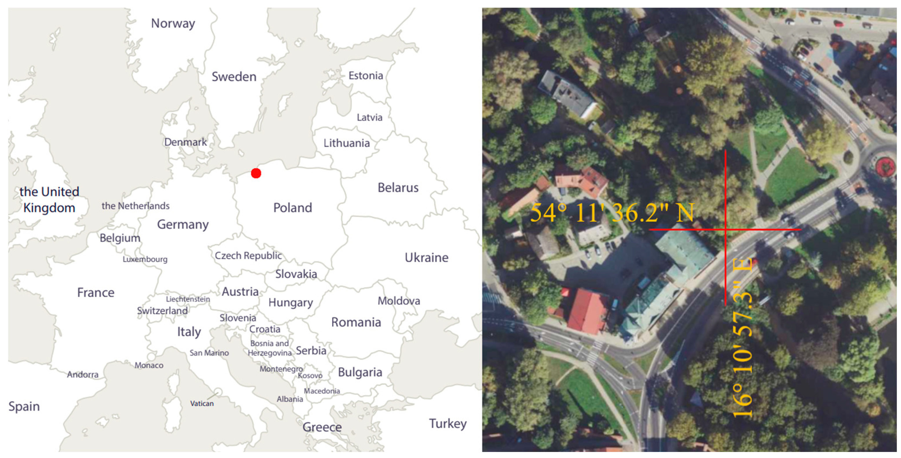
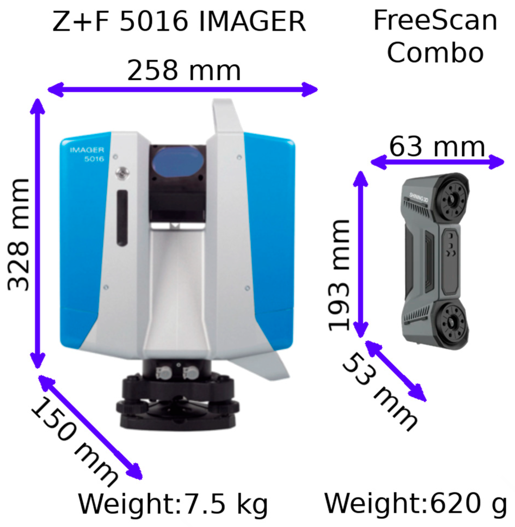
2. Measured Object and Used Tools
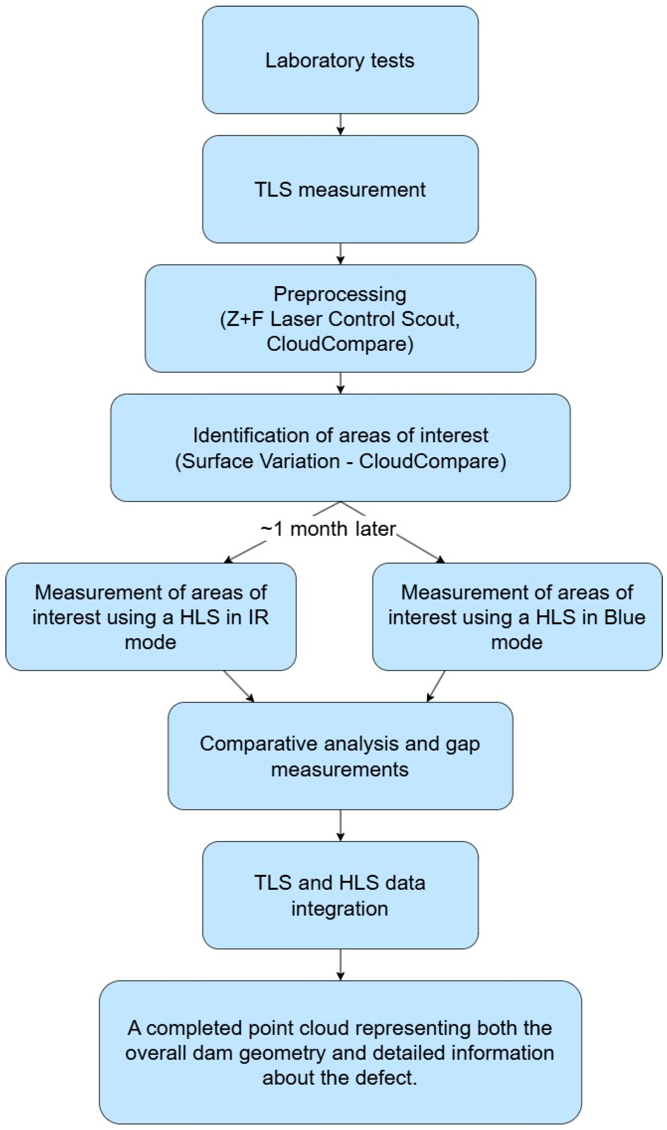
3. Workflow of the Research Program
4. Results
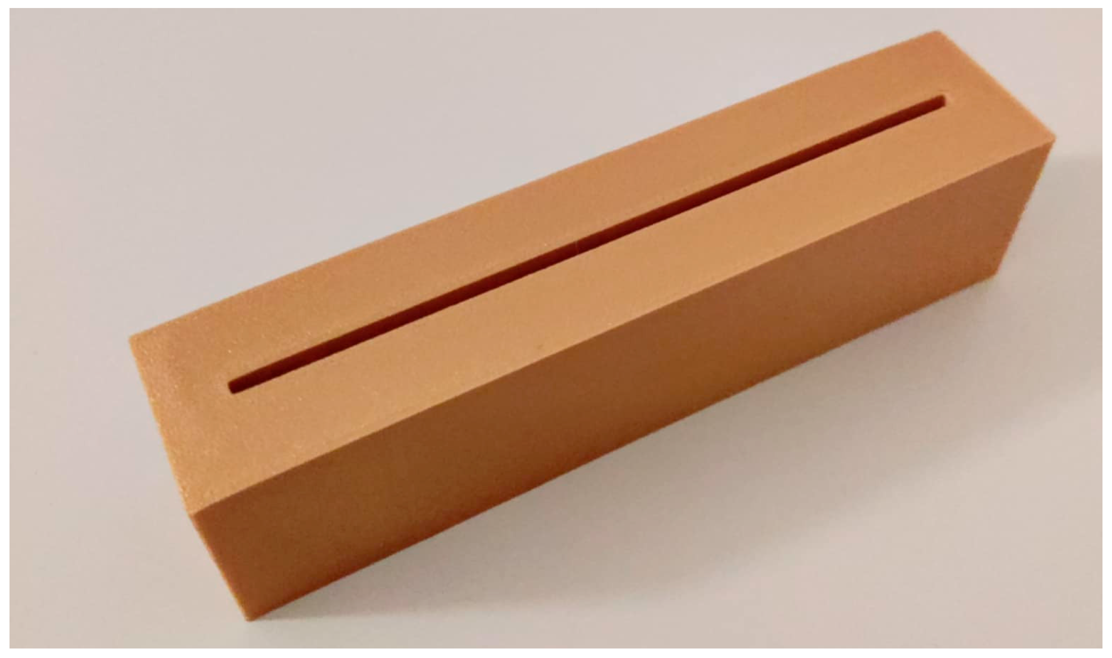
4.1. Labolatory Test
4.2. Measurement of the Small Hydropower Plant
5. Discussion
6. Conclusions
- -
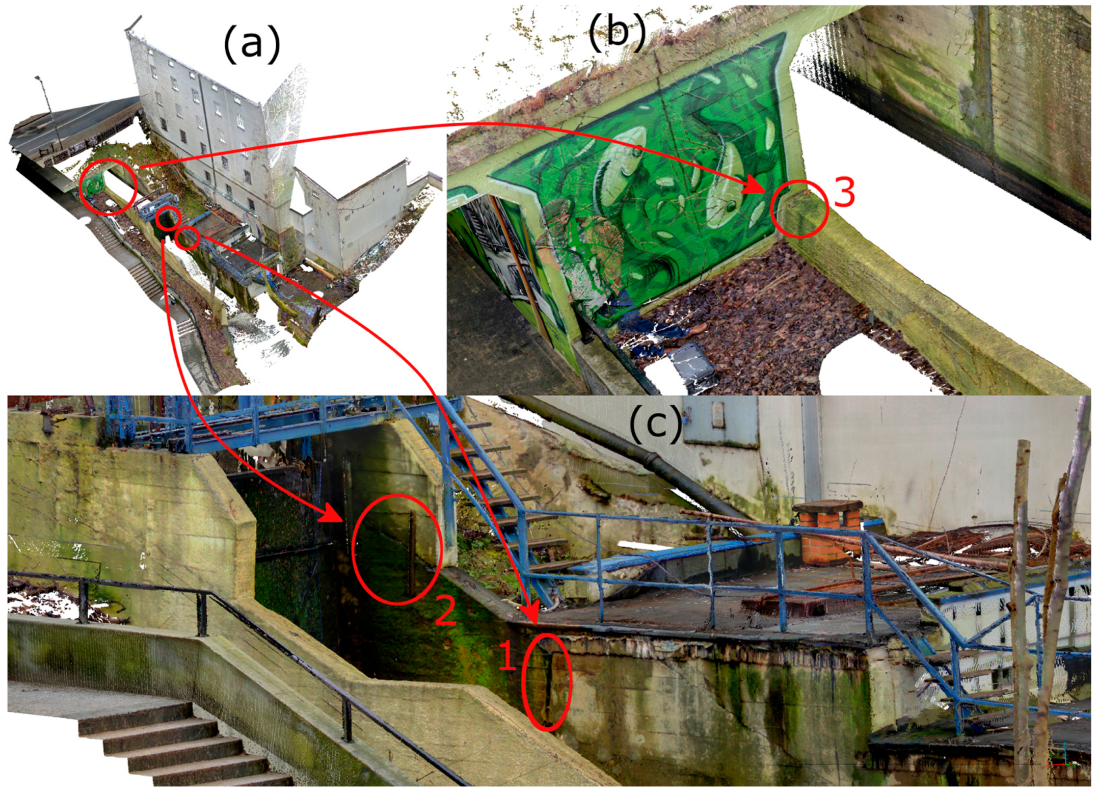
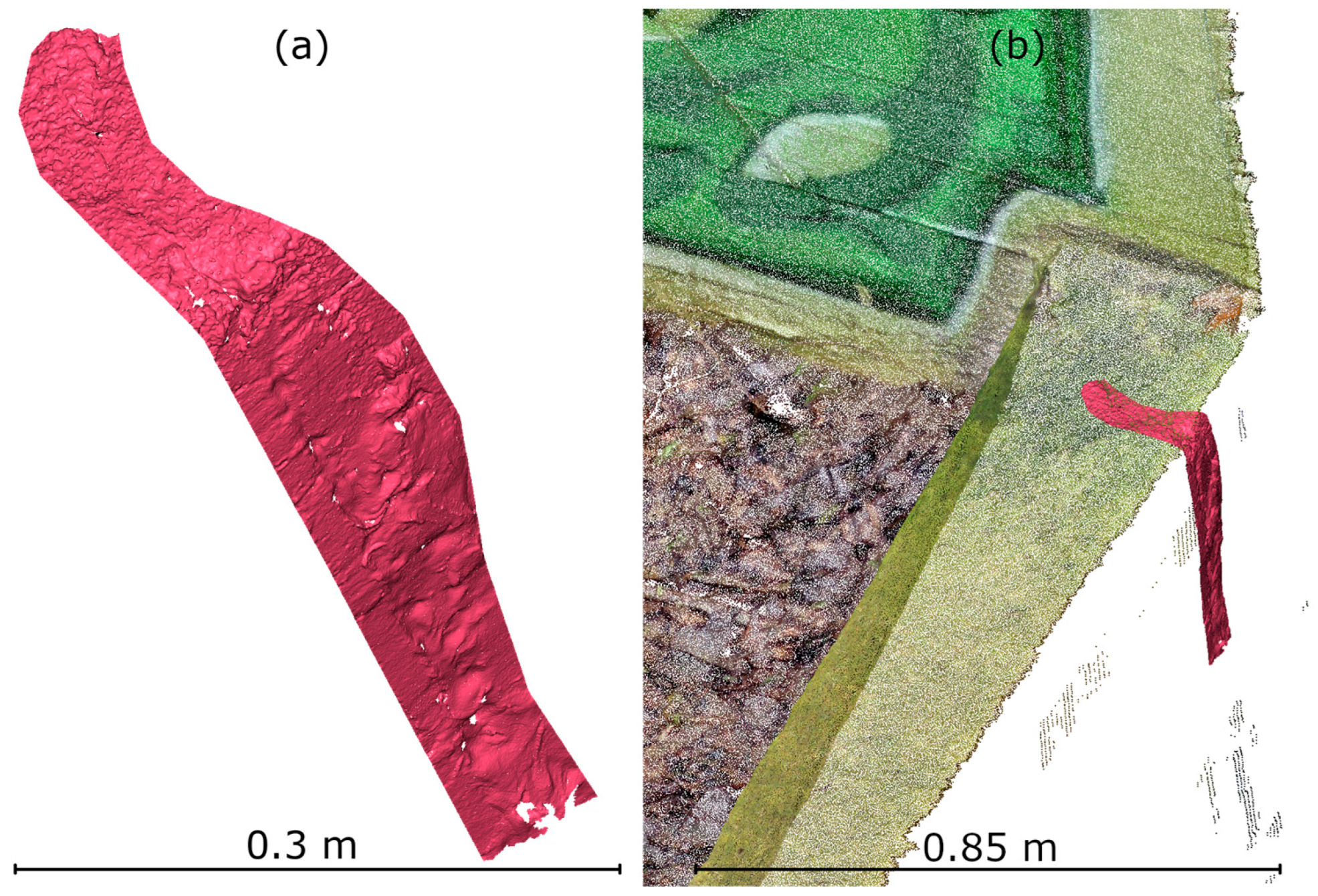
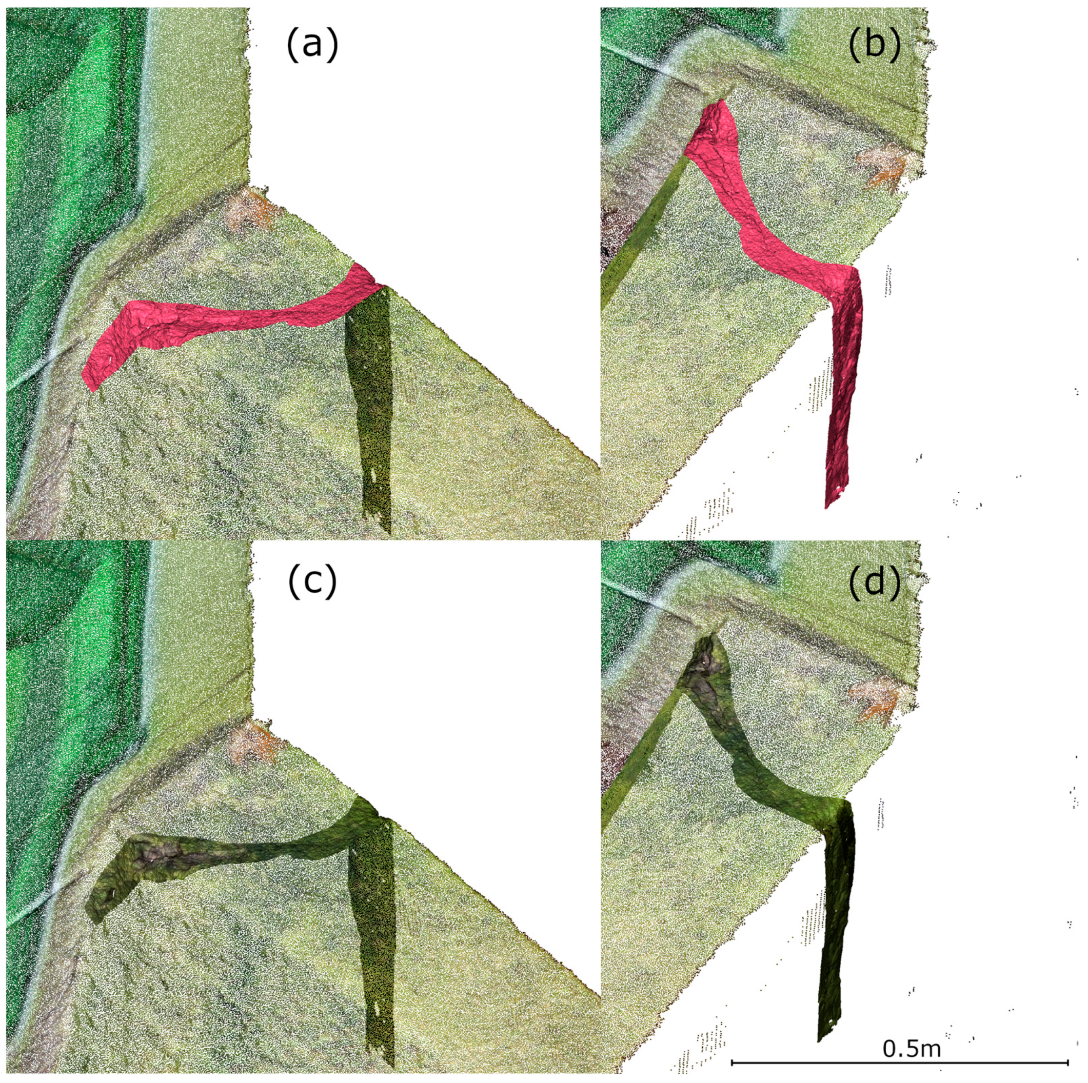
- Integration of TLS and HLS data enables accurate representation of both the overall geometry of the object and its local damage.
- -
- HLS, particularly in IR mode, allows effective measurement of hard-to-reach areas without the need for measurement markers.
- -
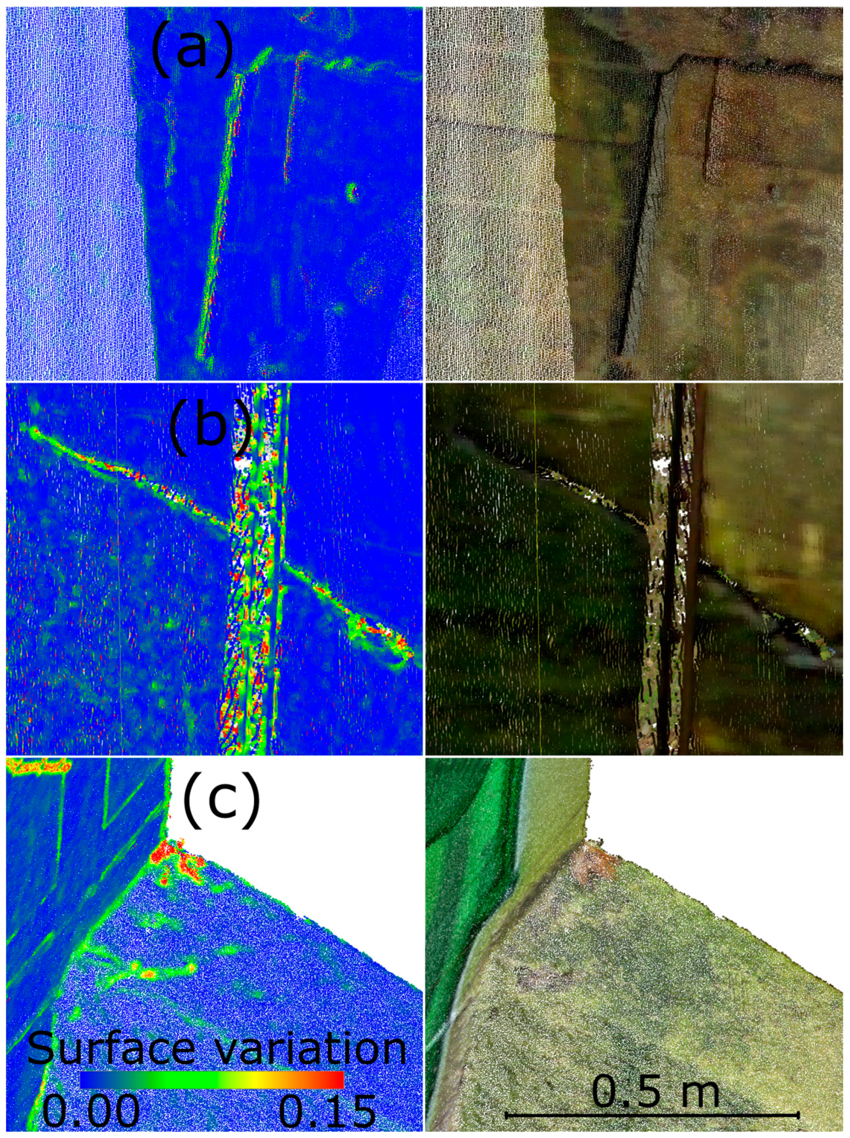
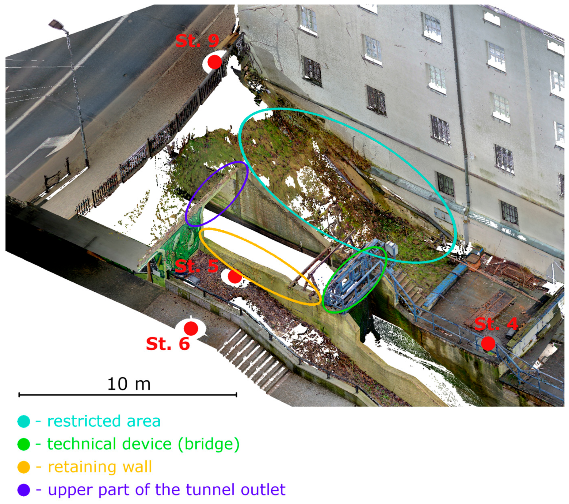
- HLS data can effectively fill TLS measurement gaps caused by object geometry or limited field access.
- -
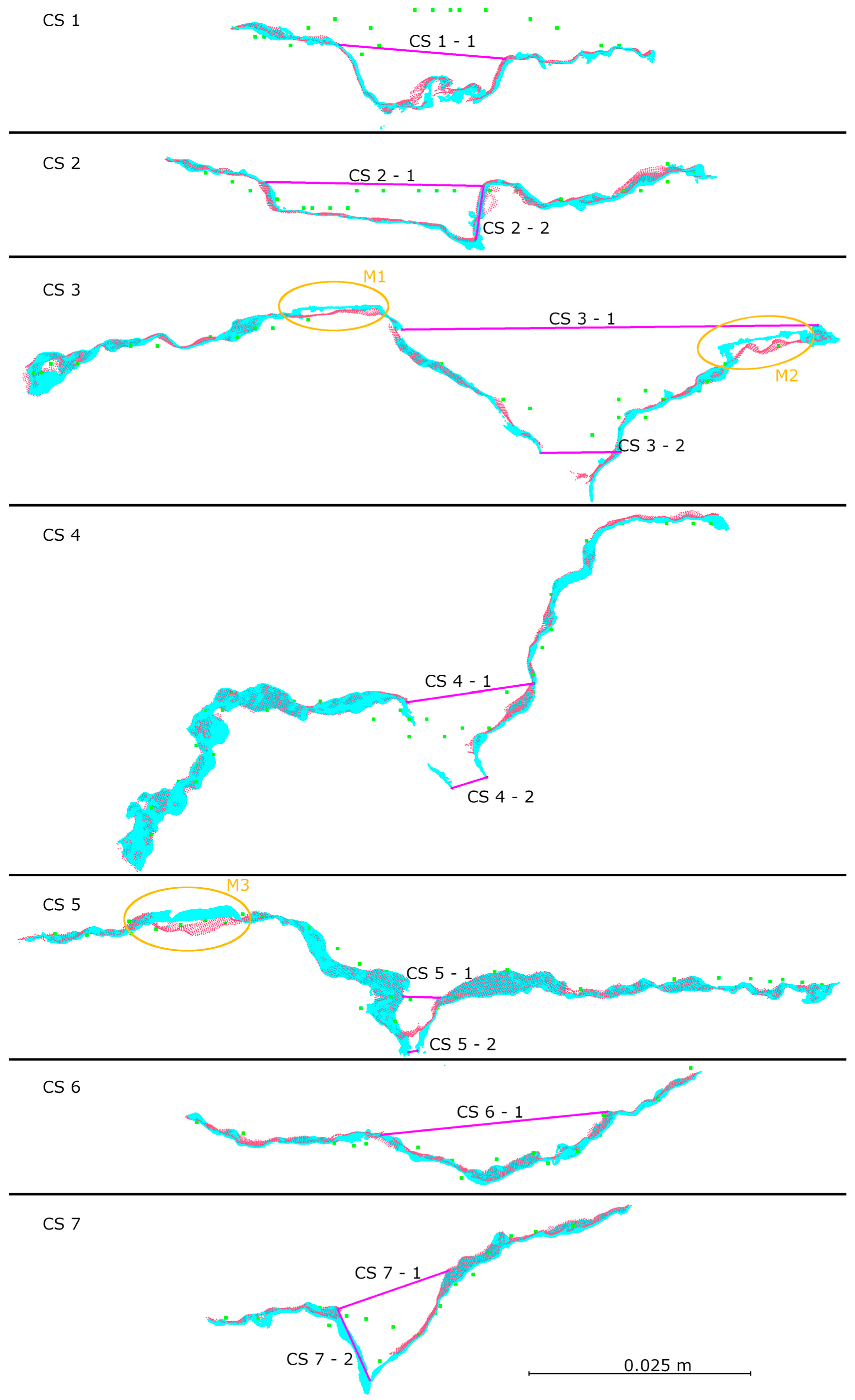
- Accuracy analysis showed high consistency of HLS data, with differences between the two available modes not exceeding 0.37 mm, confirming the device’s effectiveness in both modes.
- -
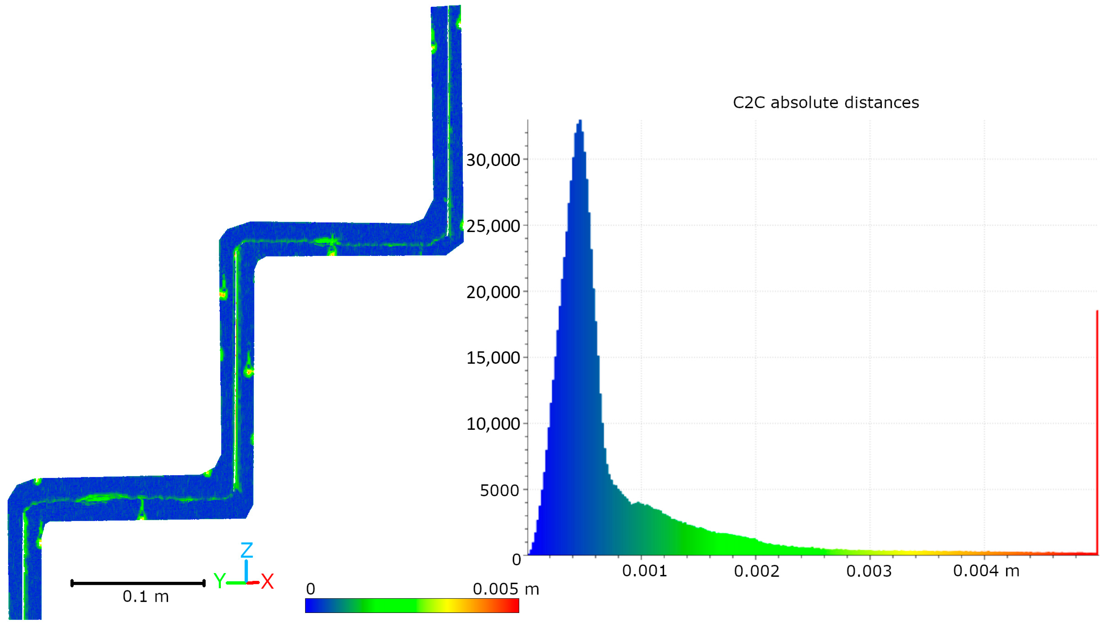
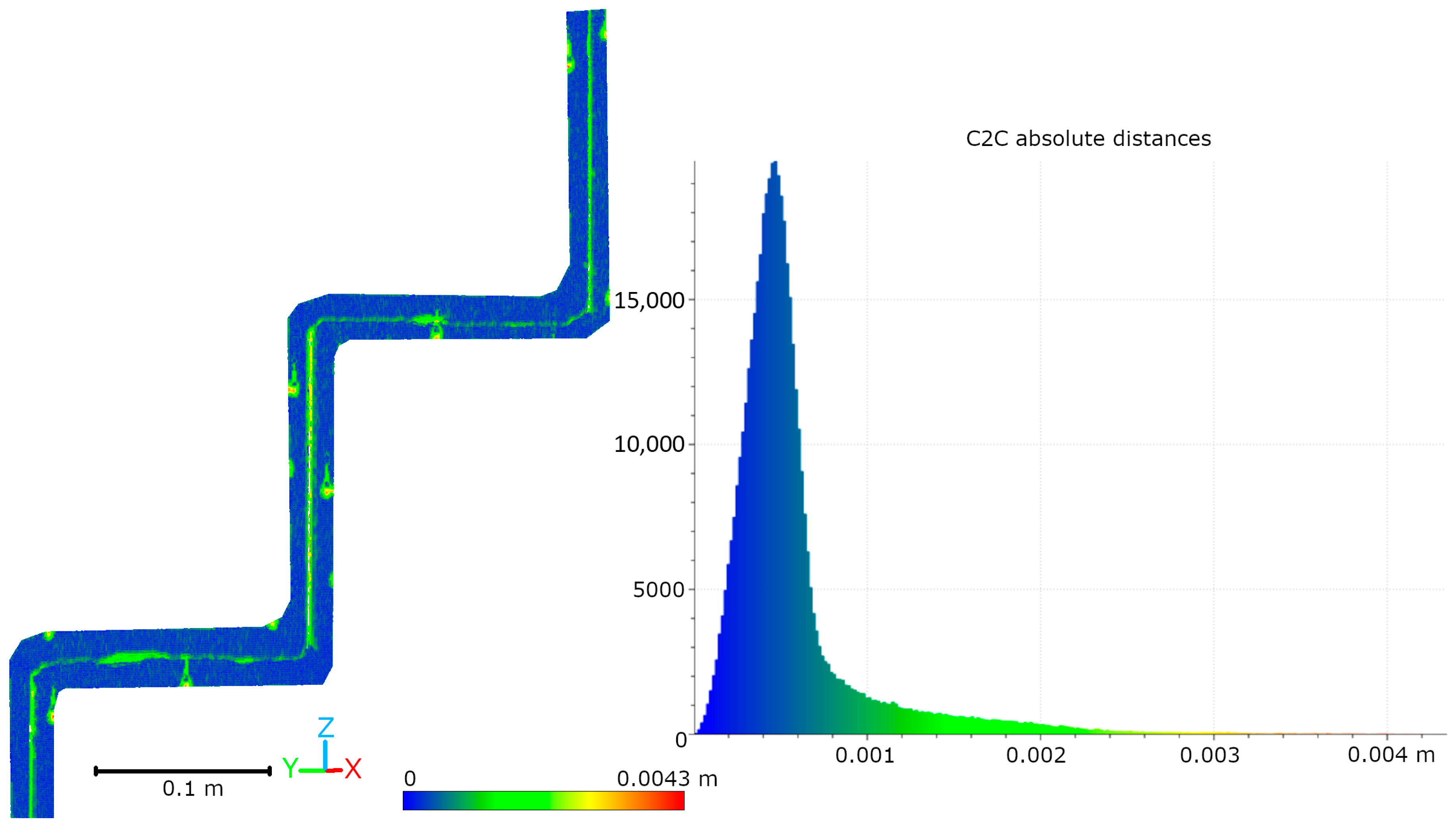
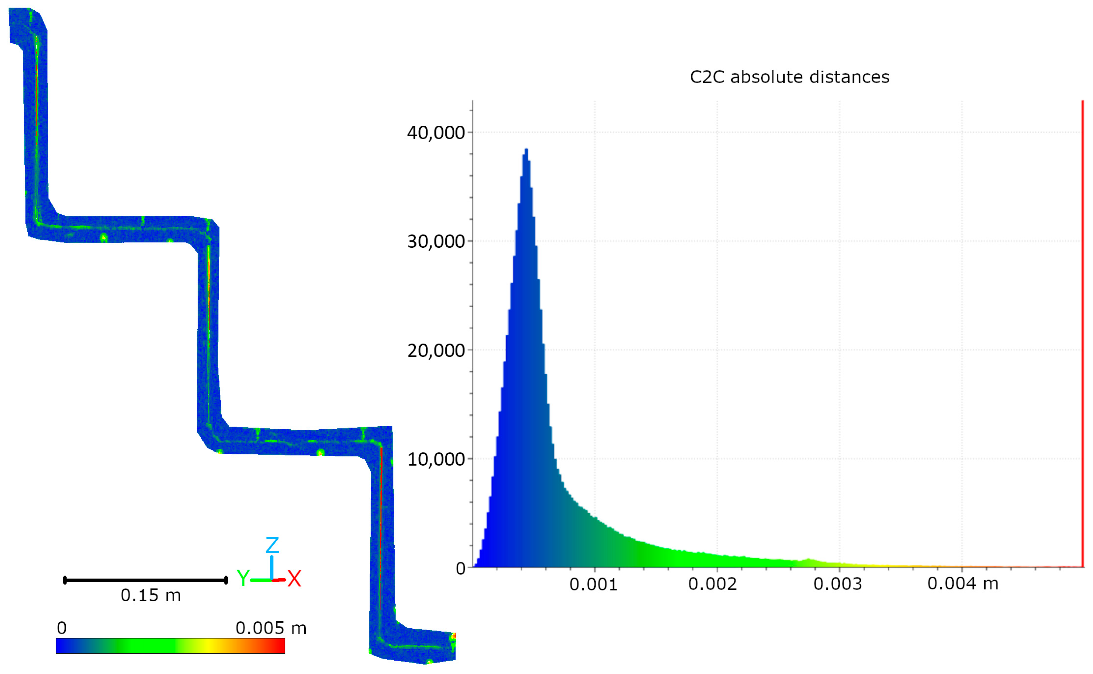
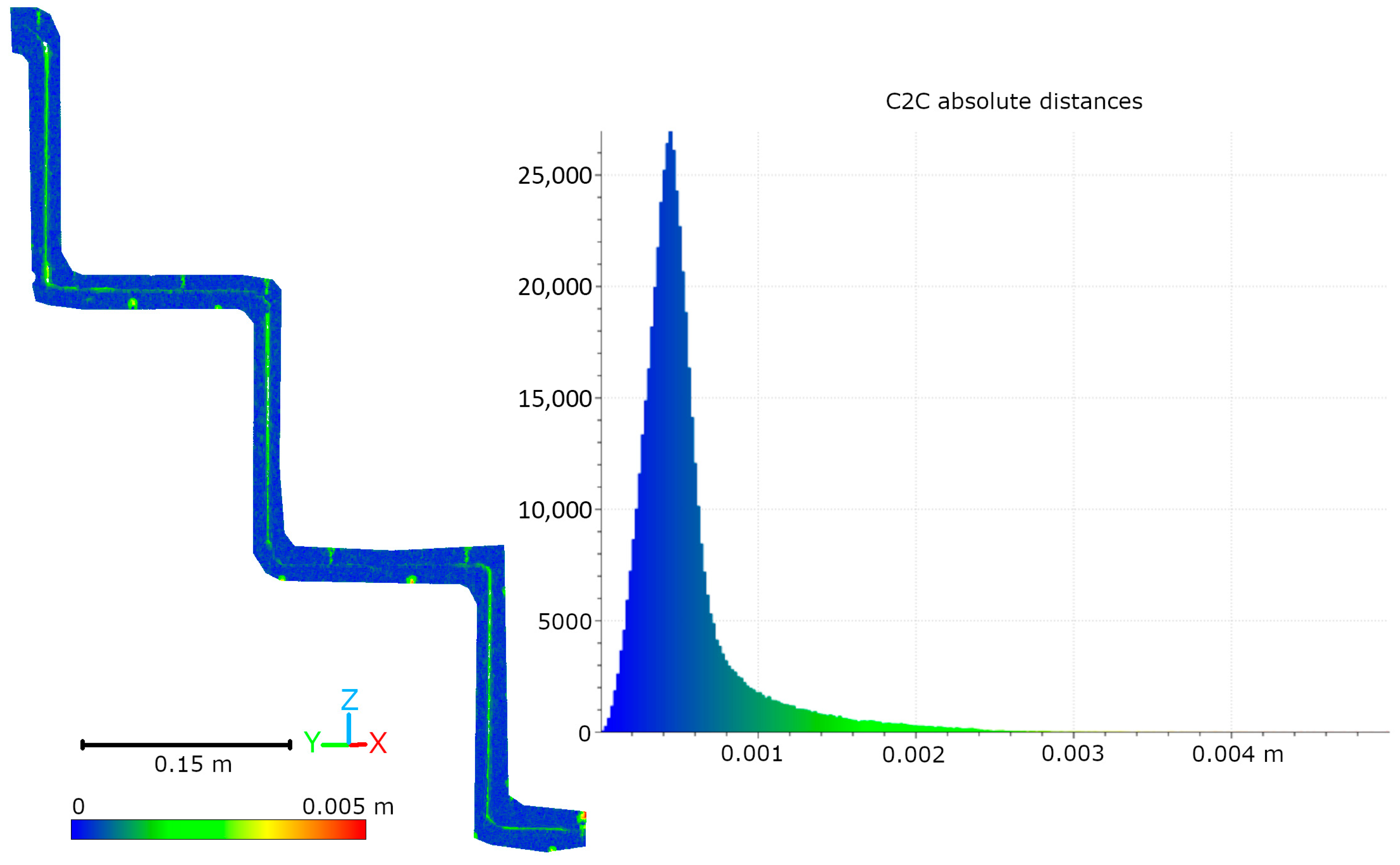
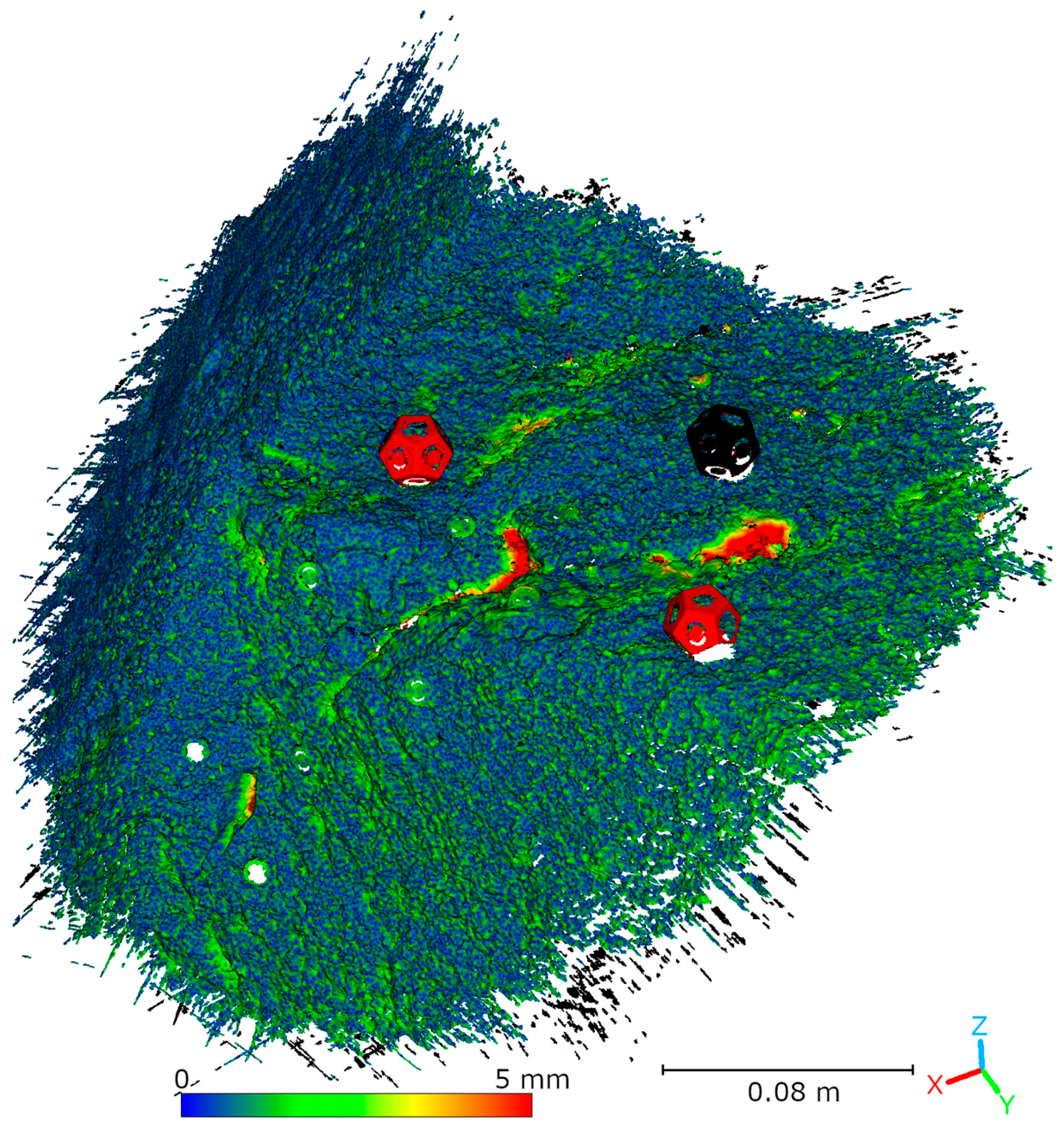
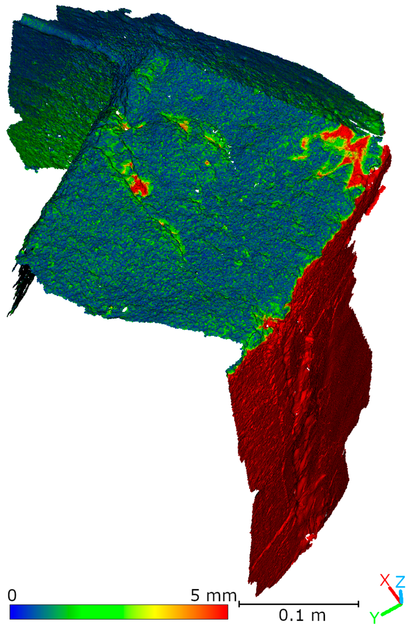
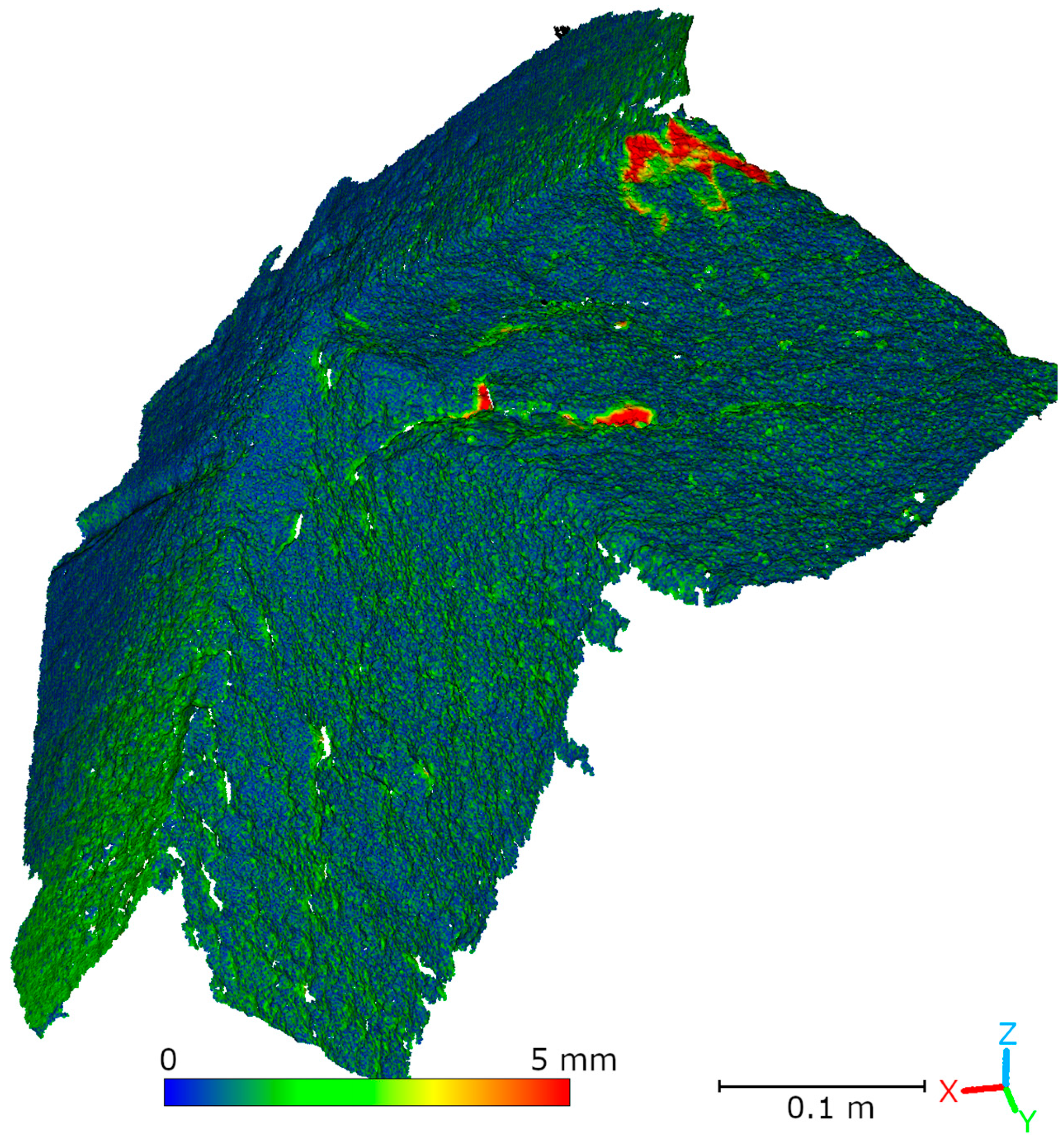
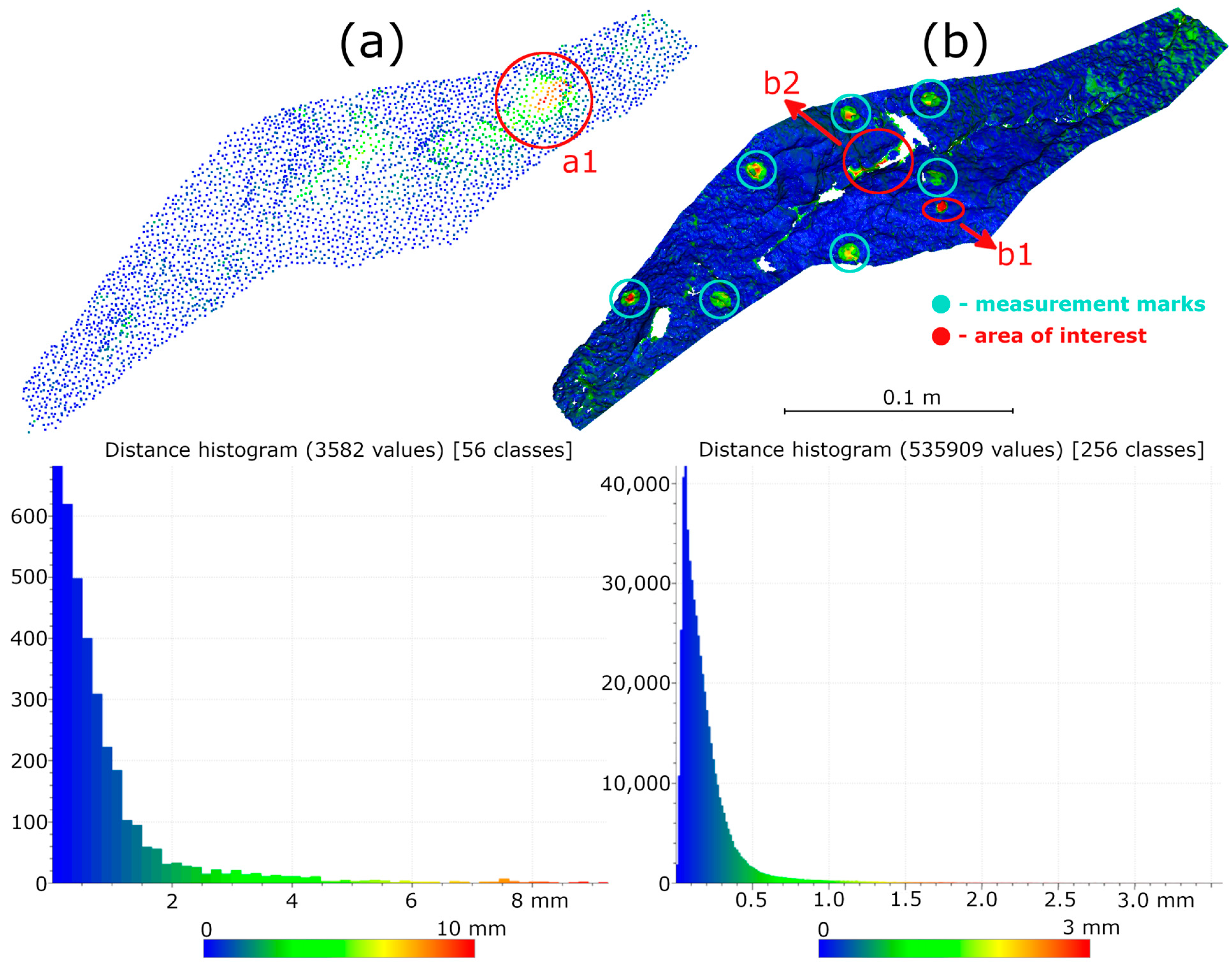
- Differences between HLS and TLS data were ≤2 mm for 90% of points and ≤1 mm for 70% of points.
- -
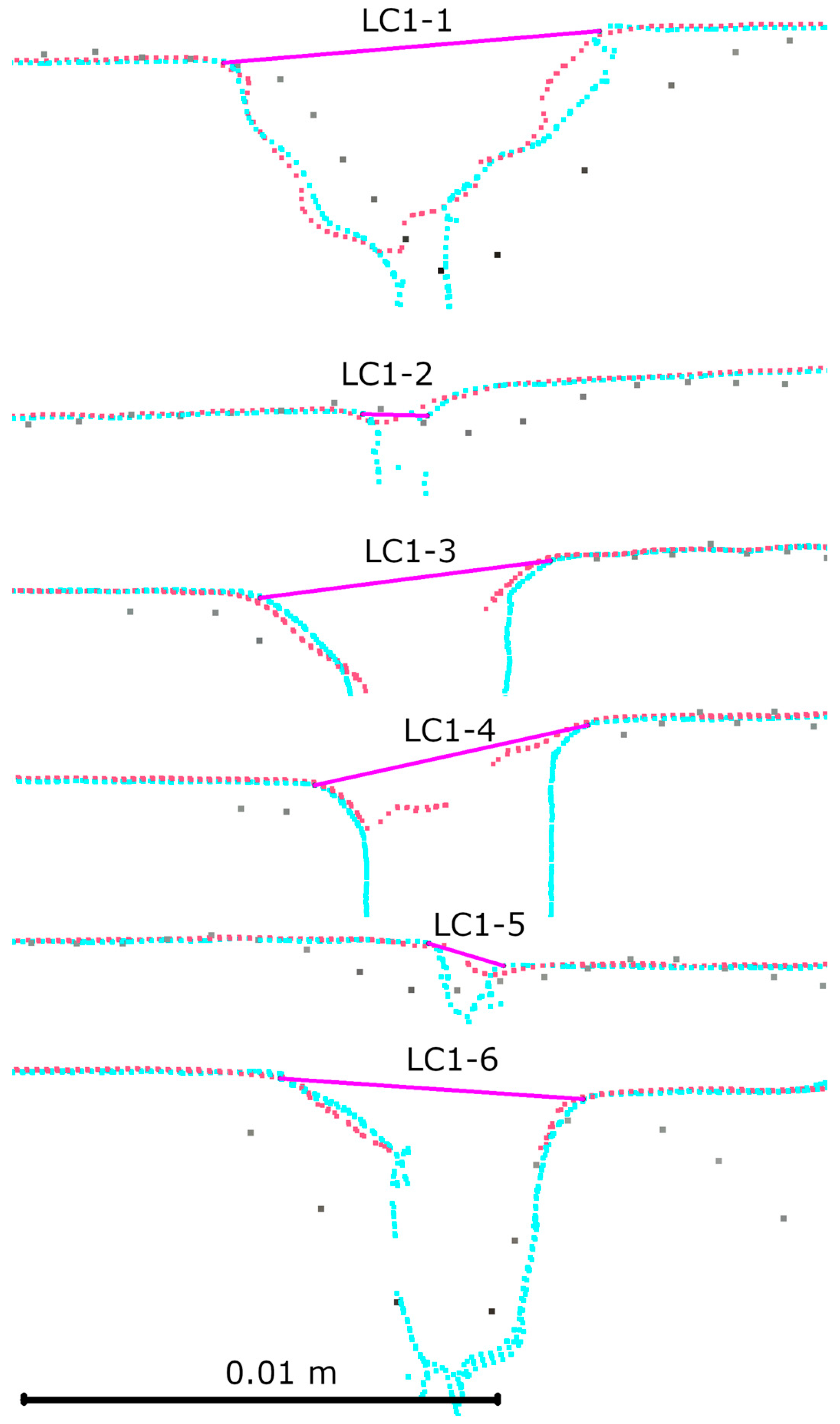
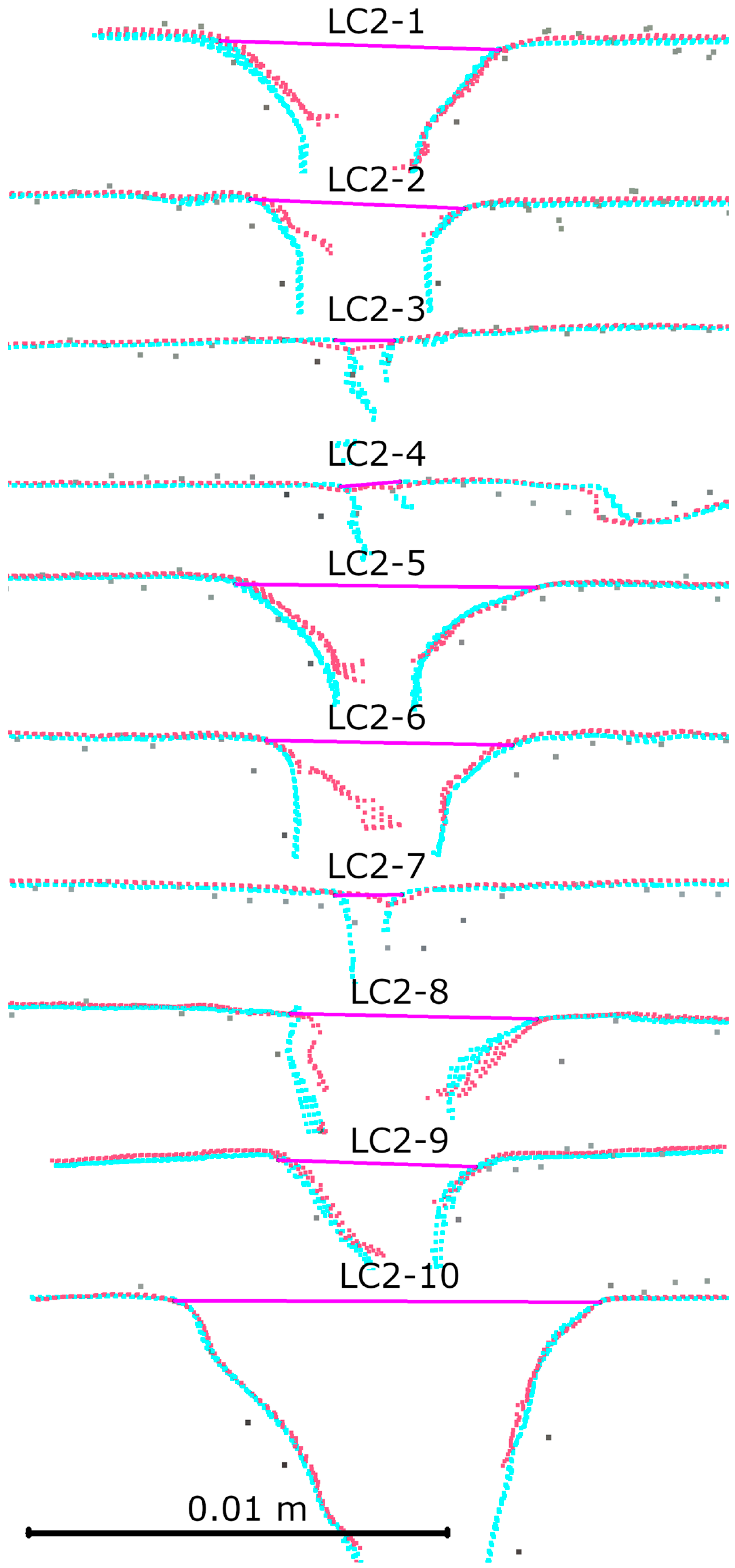
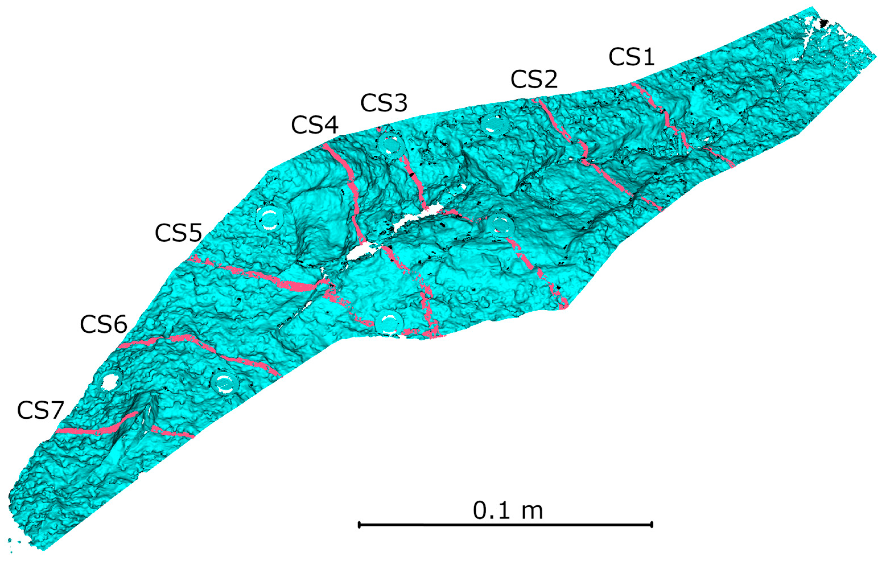
- Cross-sectional analysis of the crack enables assessment of damage geometry with submillimeter accuracy. Both HLS modes provide consistent results, with Blue mode being more effective in capturing deep cracks under varying lighting conditions.
- -
- High lighting contrast significantly hinders HLS measurements.
- -
- The hybrid approach (TLS + HLS) shows significant potential for inspections and monitoring of the technical condition of civil engineering facilities like hydraulic structures.
Author Contributions
Funding
Institutional Review Board Statement
Informed Consent Statement
Data Availability Statement
Conflicts of Interest
References
- Teng, J.; Shi, Y.; Wang, H.; Wu, J. Review on the Research and Applications of TLS in Ground Surface and Constructions Deformation Monitoring. Sensors 2022, 22, 9179. [Google Scholar] [CrossRef]
- Liu, J.; Azhar, S.; Willkens, D.; Li, B. Static Terrestrial Laser Scanning (TLS) for Heritage Building Information Modeling (HBIM): A Systematic Review. Virtual Worlds 2023, 2, 90–114. [Google Scholar] [CrossRef]
- Zhang, D.; Liu, T.; Li, S.; Luo, H.; Ding, G.; Su, Z.; Xie, C.; Zhang, S.; Feng, P. Three-dimensional laser scanning for large-scale as-built surveying of 2022 Beijing Winter Olympic Speed Skating Stadium: A case study. J. Build. Eng. 2022, 59, 105075. [Google Scholar] [CrossRef]
- Ramos-Alcázar, L.; Marchamalo-Sacristán, M.; Martínez-Marín, R. Estimating and Plotting TLS Midrange Precisions in Field Conditions: Application to Dam Monitoring. Int. J. Civ. Eng. 2017, 15, 299–307. [Google Scholar] [CrossRef]
- Ning, X.-Y.; Zhang, K.; Jiang, N.; Luo, X.-L.; Zhang, D.-M.; Peng, J.-W.; Luo, X.-X.; Zheng, Y.-S.; Guo, D. 3D deformation analysis for earth dam monitoring based on terrestrial laser scanning (TLS) and the iterative closest point (ICP) algorithm. Front. Earth Sci. 2024, 12, 1421705. [Google Scholar] [CrossRef]
- Zhao, S.; Kang, F.; Li, J.; Ma, C. Structural health monitoring and inspection of dams based on UAV photogrammetry with image 3D reconstruction. Autom. Constr. 2021, 130, 103832. [Google Scholar] [CrossRef]
- Suchocki, C.; Damięcka-Suchocka, M.; Jagoda, M. Determination of the Building Wall Deviations from the Vertical Plane. In Proceedings of the 7th International Conference on Environmental Engineering, Vilnius, Lithuania, 22–23 May 2008; pp. 1488–1492. [Google Scholar]
- Kaartinen, E.; Dunphy, K.; Sadhu, A. LiDAR-Based Structural Health Monitoring: Applications in Civil Infrastructure Systems. Sensors 2022, 22, 4610. [Google Scholar] [CrossRef] [PubMed]
- Shen, N.; Wang, B.; Ma, H.; Zhao, X.; Zhou, Y.; Zhang, Z.; Xu, J. A review of terrestrial laser scanning (TLS)-based technologies for deformation monitoring in engineering. Measurement 2023, 223, 113684. [Google Scholar] [CrossRef]
- Chen, H.; Liu, D. Numerical simulations of multiple cracks in concrete face rockfill dams coupled multi-factor during construction. Case Stud. Constr. Mater. 2025, 22, e04609. [Google Scholar] [CrossRef]
- Palčák, M.; Kudela, P.; Fandáková, M.; Kordek, J. Utilization of 3D Digital Technologies in the Documentation of Cultural Heritage: A Case Study of the Kunerad Mansion (Slovakia). Appl. Sci. 2022, 12, 4376. [Google Scholar] [CrossRef]
- Mammoli, R.; Mariotti, C.; Quattrini, R. Modeling the Fourth Dimension of Architectural Heritage: Enabling Processes for a Sustainable Conservation. Sustainability 2021, 13, 5173. [Google Scholar] [CrossRef]
- O’Banion, M.S.; Olsen, M.J.; Hollenbeck, J.P.; Wright, W.C. Data Gap Classification for Terrestrial Laser Scanning-Derived Digital Elevation Models. ISPRS Int. J. Geo-Inf. 2020, 9, 749. [Google Scholar] [CrossRef]
- Guo, M.; Sun, M.; Pan, D.; Wang, G.; Zhou, Y.; Yan, B.; Fu, Z. High-precision deformation analysis of yingxian wooden pagoda based on UAV image and terrestrial LiDAR point cloud. Herit. Sci. 2023, 11, 1. [Google Scholar] [CrossRef]
- Tysiac, P.; Sieńska, A.; Tarnowska, M.; Kedziorski, P.; Jagoda, M. Combination of terrestrial laser scanning and UAV photogrammetry for 3D modelling and degradation assessment of heritage building based on a lighting analysis: Case study—St. Adalbert Church in Gdansk, Poland. Herit. Sci. 2023, 11, 53. [Google Scholar] [CrossRef]
- Guarnieri, A.; Milan, N.; Vettore, A. Monitoring of Complex Structure for Structural Control Using Terrestrial Laser Scanning (Tls) And Photogrammetry. Int. J. Archit. Herit. 2013, 7, 54–67. [Google Scholar] [CrossRef]
- Błaszczak-Bąk, W.; Janicka, J.; Dumalski, A.; Masiero, A. Integration of Terrestrial Laser Scanning and Smartphone Lidar: The Case Study of Lidzbark Castle. ISPRS—Int. Arch. Photogramm. Remote Sens. Spat. Inf. Sci. 2023, 48, 51–56. [Google Scholar] [CrossRef]
- Kędziorski, P.; Jagoda, M.; Tysiąc, P.; Katzer, J. An Example of Using Low-Cost LiDAR Technology for 3D Modeling and Assessment of Degradation of Heritage Structures and Buildings. Materials 2024, 17, 5445. [Google Scholar] [CrossRef]
- Kędziorski, P.; Skoratko, A.; Katzer, J.; Tysiąc, P.; Jagoda, M.; Zawidzki, M. Harnessing low-cost LiDAR scanners for deformation assessment of 3D-printed concrete-plastic columns with cross-sections based on fractals after critical compressive loading. Measurement 2025, 249, 117015. [Google Scholar] [CrossRef]
- Jędrych, M.; Gorzkiewicz, D.; Deja, M.; Chodnicki, M. Application of 3D scanning and computer simulation techniques to assess the shape accuracy of welded components. Int. J. Adv. Manuf. Technol. 2025, 138, 127–135. [Google Scholar] [CrossRef]
- Osipov, S.; Komarov, I.; Zlyvko, O.; Vegera, A.; Gertsovsky, G. Development of a Methodology for Obtaining Solid Models of Products That Are Objects of Reverse Engineering Using the Example of the Capstone Micro-GTU C 65. Modelling 2024, 5, 1980–2000. [Google Scholar] [CrossRef]
- Palma, G.; Pingi, P.; Siotto, E.; Bellucci, R.; Guidi, G.; Scopigno, R. Deformation analysis of Leornado da Vinci’s “Adorazione dei Magi” through temporal unrelated 3D digitization. J. Cult. Herit. 2019, 38, 174–185. [Google Scholar] [CrossRef]
- Lunghi, I.; Vannini, E.; Dal Fovo, A.; Sarno, V.; Rocco, A.; Fontana, R. A Performance Comparison of 3D Survey Instruments for Their Application in the Cultural Heritage Field. Sensors 2024, 24, 3876. [Google Scholar] [CrossRef]
- Morena, S.; Barba, S.; Álvaro-Tordesillas, A. SHINING 3D Einscan-pro, application and validation in the field of cultural heritage, from the Chillida-leku museum to the archaeological museum of Sarno. Int. Arch. Photogramm. Remote Sens. Spat. Inf. Sci. 2019, 42, 135–142. [Google Scholar] [CrossRef]
- Zhang, L.; Yick, K.-L.; Li, P.; Yip, J.; Ng, Z. Foot deformation analysis with different load-bearing conditions to enhance diabetic footwear designs. PLoS ONE 2022, 17, e0264233. [Google Scholar] [CrossRef] [PubMed]
- van der Stelt, M.; Grobusch, M.P.; Koroma, A.R.; Papenburg, M.; Kebbie, I.; Slump, C.H.; Maal, T.J.J.; Brouwers, L. Pioneering low-cost 3D-printed transtibial prosthetics to serve a rural population in Sierra Leone—An observational cohort study. eClinicalMedicine 2021, 35, 100874. [Google Scholar] [CrossRef] [PubMed]
- Duarte, D.M.; Coimbra, W.H.M.; Massola Filho, F.F.; Martins, C.M.; Mecca Júnior, S.; de Carvalho, G.A.P. Accuracy of Different Resins Used in 3D Printing of Dental Models: In Vitro Study. Rev. Cent. Pesqui. Avançadas Qual. Vida 2025, 17, 11. [Google Scholar] [CrossRef]
- Huang, X.; Zheng, S.; Zhu, N. High-Throughput Legume Seed Phenotyping Using a Handheld 3D Laser Scanner. Remote Sens. 2022, 14, 431. [Google Scholar] [CrossRef]
- Liang, Z.; Zhou, Z.; Huang, Y.; Yang, H. Assessing apple bruise susceptibility using the discrete element method. J. Food Eng. 2025, 394, 112517. [Google Scholar] [CrossRef]
- Wu, J.; Jia, Z.; Zhou, X. Discrete element analysis of the effect of aggregate morphology on the flowability of self-compacting concrete. Case Stud. Constr. Mater. 2023, 18, e02010. [Google Scholar] [CrossRef]
- Kozlov, D.V.; Yurchenko, A.N. Importance of Timely Assessment of the Technical Condition of Hydraulic Structures to Ensure Their Failure-Free Operation. Power Technol. Eng. 2021, 55, 8–13. [Google Scholar] [CrossRef]
- Li, H.; Zhao, H.; Shen, Y.; Zheng, S.; Zhang, R. Structural Health Monitoring and Failure Analysis of Large-Scale Hydro-Steel Structures, Based on Multi-Sensor Information Fusion. Water 2024, 16, 3167. [Google Scholar] [CrossRef]
- Witek, W. Watermills and windmills in the cultural landscape of Western Pomerania [Młyny wodne i wiatraki w krajobrazie kulturowym Pomorza Zachodniego]. Zesz. Siemczyńsko-Henrykowskie 2014, 4, 55–70. [Google Scholar]
- Witek, W.; Witek, M. Watermills in Western Pomerania (Sources of Historical Energy) [Młyny Wodne na Pomorzu Zachodnim (Źródła Historycznej Energii)]. In Z Nurtem Rzeki = Au Fil de l’Eau; Biuro Dokumentacji Zabytków: Szczecin, Poland, 2014; pp. 29–47. ISBN 978-83-933448-3-3. [Google Scholar]
- Koszalin City Hall. Hazard Analysis, Including Identification of Places Where There is a Risk to the Safety of People Using Water Areas for Swimming, Bathing, Practicing Sports or Recreation in the City of Koszalin. In Urząd Miejski w Koszalinie Analiza Zagrożeń w tym Identyfikacja Miejsc, w Których Występuje Zagrożenie dla Bezpieczeństwa osób Wykorzystujących Obszar Wodny do Pływania, Kąpania się, Uprawiania Sportu lub Rekreacji na Terenie Miasta Koszalin; Urząd Miejski w Koszalinie: Koszalin, Poland, 2024. [Google Scholar]
- Suchocki, C.; Nowak, R.; Rutkowski, R.; Błaszczak-Bąk, W. Using handheld 3D laser scanner and high-resolution handheld digital microscope for hybrid building condition measurements. Measurement 2025, 253, 117751. [Google Scholar] [CrossRef]
- Frisky, A.Z.K.; Fajri, A.; Brenner, S.; Sablatnig, R. Acquisition Evaluation on Outdoor Scanning for Archaeological Artifact Digitalization. In Proceedings of the 15th International Joint Conference on Computer Vision, Imaging and Computer Graphics Theory and Applications (VISIGRAPP 2020)—Volume 5: VISAPP; SciTePress: Valletta, Malta, 2020; pp. 792–799. [Google Scholar]
- Chen, W.; Liu, X.; Ru, C.; Sun, Y. Automated Exposures Selection for High Dynamic Range Structured-Light 3-D Scanning. IEEE Trans. Ind. Electron. 2023, 70, 7428–7437. [Google Scholar] [CrossRef]
- Voisin, S.; Foufou, S.; Truchetet, F.; Page, D.L.; Abidi, M.A. Abidi Study of ambient light influence for three-dimensional scanners based on structured light. Opt. Eng. 2007, 46, 030502. [Google Scholar] [CrossRef]
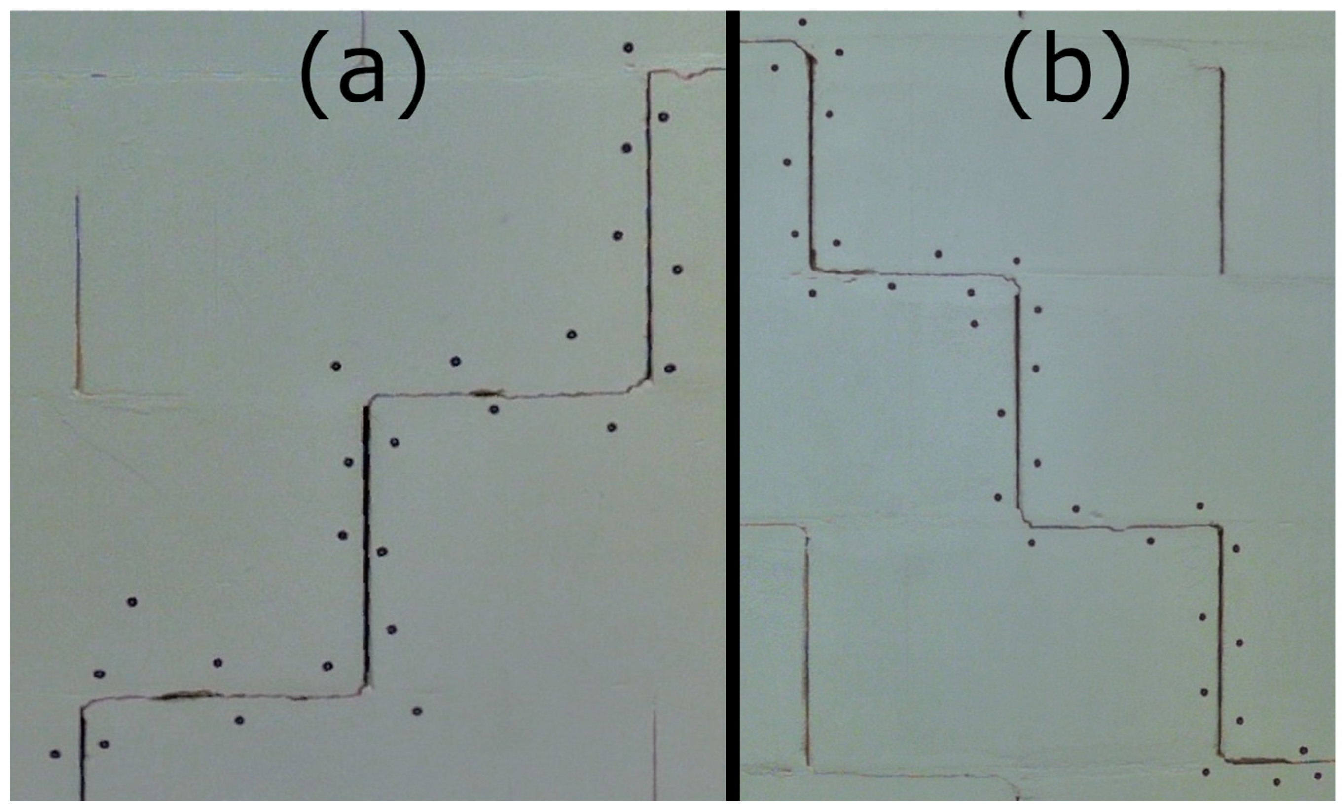
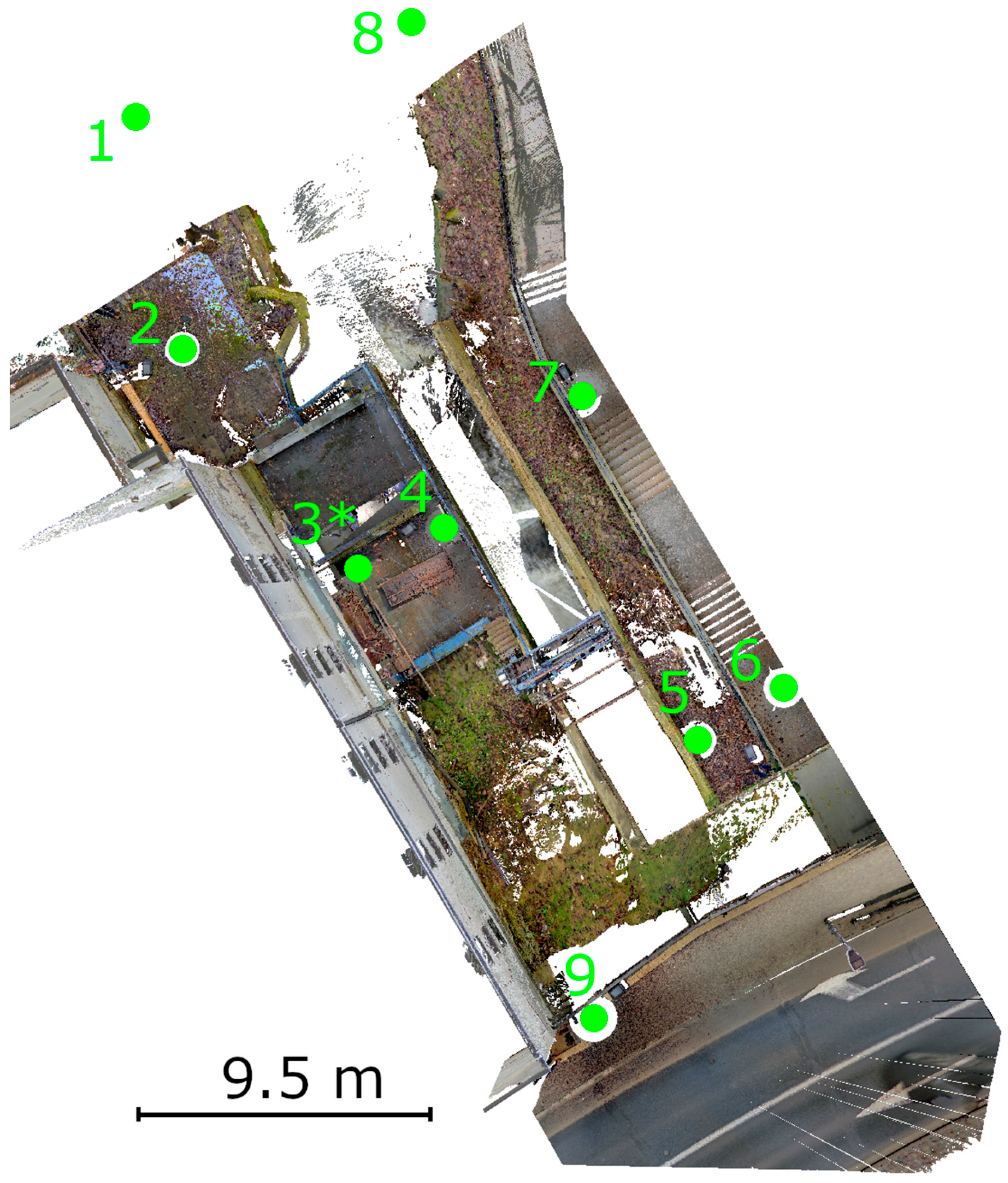
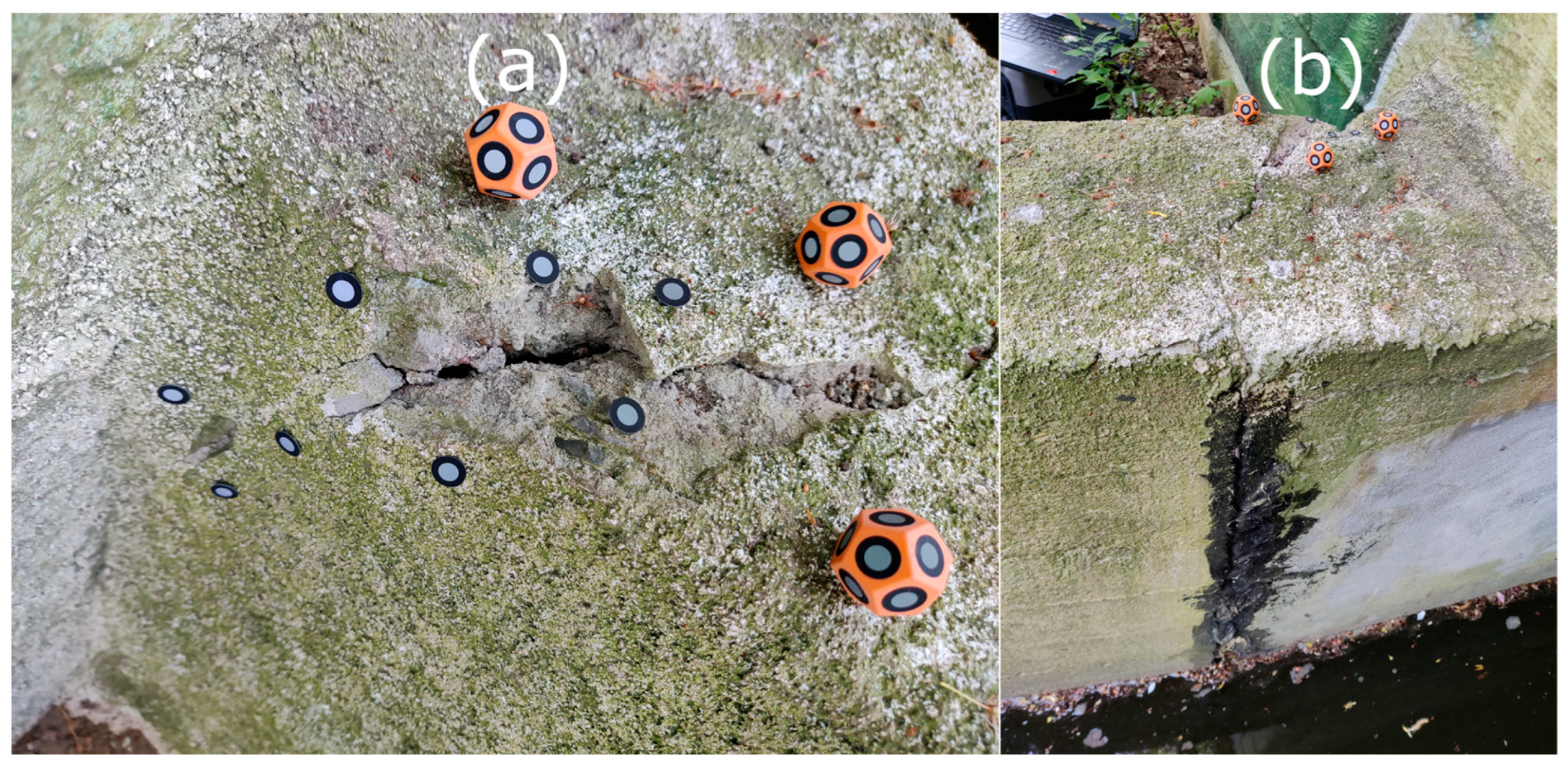
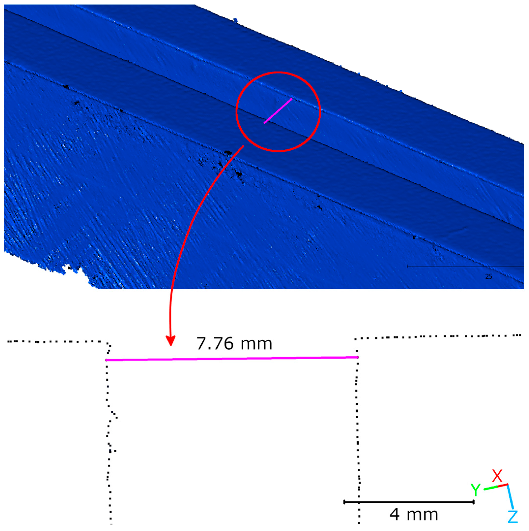

| Nominal Width (mm) | Iteration (mm) | Mean (mm) | Difference (mm) | Std. (mm) | ||
|---|---|---|---|---|---|---|
| I | II | III | ||||
| 2.5 | 2.64 | 2.63 | 2.75 | 2.67 | 0.17 | 0.05 |
| 5 | 5.16 | 5.08 | 5.09 | 5.11 | 0.11 | 0.04 |
| 7.5 | 7.75 | 7.76 | 7.64 | 7.72 | 0.22 | 0.05 |
| Cross Section | HLS IR [mm] | HLS Blue [mm] | Difference [mm] |
|---|---|---|---|
| LC1-1 | 8.4 | 8 | −0.4 |
| LC1-2 | m.n.p. | 1.4 | m.n.p. |
| LC1-3 | 6.4 | 6.2 | −0.2 |
| LC1-4 | m.n.p. | 5.9 | m.n.p. |
| LC1-5 | m.n.p. | 1.7 | m.n.p. |
| LC1-6 | 6.1 | 6.4 | 0.3 |
| LC2-1 | 7 | 6.7 | −0.3 |
| LC2-2 | 5.2 | 5.1 | −0.1 |
| LC2-3 | m.n.p. | 1.4 | m.n.p. |
| LC2-4 | m.n.p. | 1.5 | m.n.p. |
| LC2-5 | 7.3 | 7.3 | 0 |
| LC2-6 | 6.2 | 6 | −0.2 |
| LC2-7 | m.n.p. | 1.6 | m.n.p. |
| LC2-8 | 5.7 | 6 | 0.3 |
| LC2-9 | 6.8 | 6.3 | −0.5 |
| LC2-10 | 10.3 | 10.4 | 0.1 |
| Range [mm] | <0.5 | 0.5–1.0 | 1.0–1.5 | 1.5–2.0 | 2.0–2.5 | 2.5–3.0 | 3.0–3.5 | 3.5–4.0 | 4.0–4.5 | >4.5 |
| Points within range | 13.4% | 50.9% | 25.0% | 4.8% | 1.4% | 0.7% | 0.5% | 0.4% | 0.3% | 2.8% |
| Cumulative percentage of points | 13.4% | 64.3% | 89.2% | 94.0% | 95.4% | 96.1% | 96.6% | 97.0% | 97.2% | 100.0% |
| Range [mm] | <0.5 | 0.5–1.0 | 1.0–1.5 | 1.5–2.0 | 2.0–2.5 | 2.5–3.0 | 3.0–3.5 | 3.5–4.0 | 4.0–4.5 | >4.5 |
| Points within range | 8.1% | 33.4% | 19.4% | 4.4% | 1.1% | 0.4% | 0.3% | 0.2% | 0.2% | 32.4% |
| Cumulative percentage of points | 8.1% | 41.5% | 60.9% | 65.3% | 66.4% | 66.8% | 67.1% | 67.4% | 67.6% | 100.0% |
| Range [mm] | <0.5 | 0.5–1.0 | 1.0–1.5 | 1.5–2.0 | 2.0–2.5 | 2.5–3.0 | 3.0–3.5 | 3.5–4.0 | 4.0–4.5 | >4.5 |
| Points within range | 12.0% | 49.3% | 28.3% | 6.2% | 1.7% | 0.6% | 0.4% | 0.3% | 0.2% | 1.0% |
| Cumulative percentage of points | 12.0% | 61.3% | 89.6% | 95.8% | 97.4% | 98.0% | 98.4% | 98.7% | 99.0% | 100.0% |
| Cross Section | Measurement | HLS IR [mm] | HLS Blue [mm] | Difference [mm] |
|---|---|---|---|---|
| CS 1 | CS 1-1 | 18.7 | 18.9 | 0.3 |
| CS 2 | CS 2-1 | 24.2 | 24.5 | 0.3 |
| CS 2-2 | 6.2 | 6.2 | 0.0 | |
| CS 3 | CS 3-1 | 47.5 | 46.9 | −0.6 |
| CS 3-2 | 8.8 | 9.0 | 0.2 | |
| CS 4 | CS 4-1 | 14.1 | 14.5 | 0.4 |
| CS 4-2 | m.n.p. | 4.1 | m.n.p. | |
| CS 5 | CS 5-1 | 4.0 | 4.2 | 0.1 |
| CS 5-2 | m.n.p. | 1.5 | m.n.p. | |
| CS 6 | CS 6-1 | 25.5 | 25.6 | 0.1 |
| CS 7 | CS 7-1 | 13.2 | 13.3 | 0.2 |
| CS 7-2 | m.n.p. | 8.8 | m.n.p. |
Disclaimer/Publisher’s Note: The statements, opinions and data contained in all publications are solely those of the individual author(s) and contributor(s) and not of MDPI and/or the editor(s). MDPI and/or the editor(s) disclaim responsibility for any injury to people or property resulting from any ideas, methods, instructions or products referred to in the content. |
© 2025 by the authors. Licensee MDPI, Basel, Switzerland. This article is an open access article distributed under the terms and conditions of the Creative Commons Attribution (CC BY) license (https://creativecommons.org/licenses/by/4.0/).
Share and Cite
Kędziorski, P.; Katzer, J.; Jagoda, M. Integration of TLS and HLS Data for Non-Destructive Structural Damage Assessment of Building Structures: A Case Study of a Small Hydropower Plant. Materials 2025, 18, 5352. https://doi.org/10.3390/ma18235352
Kędziorski P, Katzer J, Jagoda M. Integration of TLS and HLS Data for Non-Destructive Structural Damage Assessment of Building Structures: A Case Study of a Small Hydropower Plant. Materials. 2025; 18(23):5352. https://doi.org/10.3390/ma18235352
Chicago/Turabian StyleKędziorski, Piotr, Jacek Katzer, and Marcin Jagoda. 2025. "Integration of TLS and HLS Data for Non-Destructive Structural Damage Assessment of Building Structures: A Case Study of a Small Hydropower Plant" Materials 18, no. 23: 5352. https://doi.org/10.3390/ma18235352
APA StyleKędziorski, P., Katzer, J., & Jagoda, M. (2025). Integration of TLS and HLS Data for Non-Destructive Structural Damage Assessment of Building Structures: A Case Study of a Small Hydropower Plant. Materials, 18(23), 5352. https://doi.org/10.3390/ma18235352


