Abstract
Due to the favorable condition of arid and cold climates for ever-increasing photovoltaic installations by supporting them to operate around their maximum power, it would be interesting to evaluate the solar potential of this climate. In this study, we proposed a simple, semi-empirical model to estimate the global horizontal irradiance (GHI) from the high-resolution visible channel satellite data provided by the Japanese meteorological satellite Himawari 8/9. The site adaptation procedure uses approximately 2–3 years of data recorded at four ground stations in Mongolia’s arid and cold regions to optimize the model parameters in a lookup table. Then, the model’s performance is evaluated using the independent test data of 1–2 years. The previous version of the proposed model and shortwave radiation product retrieved from the JAXA’s P-Tree system are also used for benchmarking as baselines. As a result, we found that the performance of the proposed model under a time granularity of 10 min surpassed them with an RMSE of 85 W/m2 in an arid desert to 114 W/m2 in a cold climate. A significant improvement was especially noticed in the capital city of Ulaanbaatar, where the resulting RMSE was 13 W/m2 and 131 W/m2 lower than the baseline models.
1. Introduction
The first solar cell to convert solar energy into electricity was developed in 1954 at Bell Laboratories [1]. Despite that, its terrestrial use was limited due to lower efficiency and higher manufacturing costs. However, solar photovoltaic (PV) panels have become more affordable and efficient through continuous efforts in collaboration between various industries and academia. According to the study by the International Renewable Energy Agency (IRENA), on average, the levelized cost of electricity (LCOE) of a large-scale PV power plant equals 0.048 USD/kWh in 2021, which means a reduction of 88% from 2010 [2]. This is coupled with the improvement in cell efficiency. For instance, the highest efficiency of crystalline silicon solar cells in the research environment has almost doubled from 13.9% in 1977 to 26.1% in 2018 [3]. The after-effects of the above-mentioned welcoming factors can be highlighted by the fact that on a global scale, the total installed capacity of PV has grown exponentially from 100 GW to 1185 GW between 2012 and 2022 [4]. The environmental crisis further enabled the transition towards sustainable and green energy, avoiding the traditional generation methods based on fossil fuels. Therefore, installations of PV systems are expected to rise continually in the years to come.
Following the current–voltage (IV) curve of a semiconductor solar cell, the solar irradiance and the ambient temperature affect the power output [5]. The output voltage and, ultimately, the power yield of the solar cell starts to decrease when the cell temperature is above 25 °C, known as the standard test conditions (STCs) [6]. Therefore, it is ideal for installing utility-scale PV systems in arid and cold climates, specifically cold deserts, thanks to their strong solar insolation, very little precipitation, low ambient temperature, and vast area [7]. This environment allows PV modules to operate around their maximum power point (MPP), resulting in elevated energy production and economic benefits.
The Gobi Desert, located in southern Mongolia and northwestern China, is the third-largest non-polar and the largest cold desert in the world [8]. The wind resource of the Gobi Desert is also abundant, which makes it one of the most promising sites for exploiting variable renewable energy resources [9]. Additionally, because it is close to the large demand for electric energy in northeast Asia, including Russia, China, South Korea, and Japan, the Gobitec, also known as the Asian super grid (ASG) initiative, is proposed. Although it is still visionary if implemented, it would benefit all participants concerning economic, social, and environmental aspects [10].
Considering the intermittent characteristics of solar energy, a thorough analysis of the solar resource should be the focal point during the initial phase of the project development. Unfortunately, previous attempts to study the solar potential of the arid and cold climate regions are unsatisfactory, such as heavily relying on either the limited number of ground measurements [11,12] or physical modeling by the geographic information system (GIS) [13].
Regarding the input source of data in solar resource assessment tasks, satellite data have been commonly used because of the capability of monitoring over a wide area where a constellation of satellites covers the globe between the latitudinal 60° N and 60° S [14]. For example, a physics-based Fast All-sky Radiation Model for Solar applications (FARMS), which retrieves the atmospheric and cloud properties from the Geostationary Operational Environmental Satellite (GOES), is utilized in the National Solar Radiation Database (NSRDB) to monitor all components of the solar irradiance over the continental US [15]. Novel satellites with improved spatial and temporal resolution such as Japanese Himawari and China’s Fengyun-4A satellites further drive the use of satellite data in the solar resource assessment framework [16,17].
However, the temporal resolution of satellite observations is lower compared to that of ground-based measurements. Additionally, since a satellite pixel represents a larger area on the scale of several kilometers, it is challenging to accurately capture the actual pinpoint ground conditions. For this reason, the site adaptation technique helps to improve bankability by establishing a relationship between satellite observation and ground measurement, also known as a hybrid, semi-physical, or semi-empirical model [14]. The classical Perez model based on the radiative transfer mechanism, which uses hourly visible channel image data from the GOES, estimates the global horizontal irradiance (GHI) and direct normal irradiance (DNI) in the US where ground measurement stations with different climates were used for the development and validation of the model [18]. In Ref. [19], to estimate the GHI, Otani et al. developed a methodology to first calculate the ground albedo from the planetary albedo provided by the visible channel data of the Geostationary Meteorological Satellite (GMS) series because not only the atmospheric but also the ground condition is captured in the satellite image. Then, the semi-empirical model estimates the GHI at various locations in Japan, but the spatial resolution was low due to the limited capability of the satellite imager where each pixel represents an area of 25 km2. Han et al. used the most recent version of the GMS with an increased imaging functionality in terms of the number of observation bands and resolution known as Himawari 8 to estimate the solar potential of Taipei by implementing the Heliosat model, which receives visible channel No. 3 as an input [20]. Similarly, Alonso et al. estimated the direct, diffuse, and global irradiances by using the European Solar Radiation Atlas (ESRA) clear sky and Heliosat 2 models to which Meteosat Second Generation (MSG) satellite data centered at the wavelengths of 0.6 μm and 0.8 μm in the visible spectrum out of total 12 bands are given. The estimation results are validated against the ground truth measurement at the University of Almeria, Spain, characterized by the Mediterranean climate for 5 years between 2010 and 2014 [21].
Some researchers have proposed using additional data from climate reanalysis and infrared (IR) channels of the satellite data for increased accuracy. Because the brightness temperature of the cloud is lower than that of the land surface, IR channels are used to detect clouds, which play an important role in the earth’s energy budget. Escobar et al. estimated all components of the solar irradiance over Chile by using the visible and IR channel data provided by the GOES [22]. They noticed a good agreement between the estimation and measurement on clear days where the hourly and daily relative root mean square errors (RMSEs) were 12.8% and 8.9%, respectively. However, in the case of overcast sky conditions with low irradiance values, the direct and global irradiance tends to be overestimated. In another study, Molina et al. tested the performance of a solar model with an extensive ground measurement network consisting of 140 meteorological stations in Chile because of the variety of climates such as the Atacama desert, Andean mountains, and Antarctic region [23]. The proposed model uses high-resolution GOES data with a spatiotemporal resolution of 30 min and 1 km for cloud detection. They found that the accuracy of the proposed model dropped to 80% in the cloudy region of the south compared to 95% for the rest of the country. The difficulty of distinguishing the clouds over highly reflective surfaces such as snow and salt lakes is noted even with the assistance of the IR bands [24]. A. Damiani et al. estimated surface downwelling radiation over Japan using Himawari 8 along with Japanese reanalysis data, which provide water vapor and ozone information. The results are provided with an interval of 2.5 min, where the RMSE was 110 W/m2 and 150 W/m2 for mainland and sub-tropical regions, respectively. Moreover, they evaluated their model on a longer time step of half an hour, which resulted in 20–30 W/m2 of mean bias error (MBE) and 80–105 W/m2 of RMSE. Also, they reported positive biases resulting from overestimation [25].
The above-mentioned methodologies require additional input parameters describing the atmospheric and ground profiles. Therefore, it is often retrieved from external data repositories where the spatiotemporal resolution is inferior to that of the visible band of satellite observation. In addition to the internal uncertainty of different data sources, the spatiotemporal mismatch between them introduces additional errors to the estimated irradiance. To address this, we aim to develop a simple solar estimation model based on the high-resolution visible channel satellite data enhanced with site adaptation.
In short, the main contributions of this study are (i) the proposition of a solar estimation framework where the visible channel data are used as a main input to avoid external noises from the heterogeneous data sources and (ii) the evaluation of its performance in arid and cold climate conditions considering the expected rise in the PV installation and its temperature dependence.
2. Methodology
In this study, a semi-empirical model is proposed by improving the previous model described in [19]. The original model developed by Otani et al. accounts for the reduction in clear sky irradiance through atmospheric transmittance. When ground reflection, also known as ground albedo, is known, by subtracting it from the planetary albedo (the overall reflection data provided by the spatial observation), we can estimate how much of the observed reflection is caused by the atmospheric constituents, such as clouds and aerosols. Furthermore, by tuning with the ground truth data, atmospheric transmittance can be modeled in a lookup table (LUT). In short, satellite-derived atmospheric transmittance is multiplied by the clear sky irradiance for the estimation of surface insolation.
We introduced several modifications to the original model to account for the superior sensor capability of Himawari 8/9 than its predecessor, known as GMS. First of all, while the original model receives the reflectance data from only one visible band, all three bands in the visible spectra are used in the current study. Second, we suggest implementing different sources of ground albedo instead of estimating from the planetary albedo for reduced uncertainty. Details of the data repositories are explained in Section 3. Third, we added a correction coefficient to correct any systematic errors, which cannot be modeled by the transmission coefficient alone.
Figure 1 shows the schematic diagram to estimate the GHI where the mean value of the visible channels is regarded as a planetary albedo . Because both ground and atmospheric conditions are recorded in satellite observation, ground albedo is an important factor in the solar resource assessment [26]. Thus, it is also input to the model to separate the ground feature from the satellite data leaving atmospheric info only. Geographical information is necessary to calculate the clear sky irradiance as a function of airmass and solar zenith angle , which are computed by the solar position algorithm [27]. Finally, when all inputs are provided, with Equation (1), solar irradiance on the ground level can be computed, but model parameters and need to be determined beforehand. Whilst the correction coefficient accounts for the intrinsic error found in the semi-empiric solar estimation model, transmission coefficient approximates the atmospheric phenomena such as absorption and scattering.
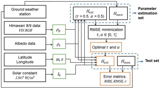
Figure 1.
Flowchart of implementing the GHI estimation model. Inputs and outputs are shown in green and yellow boxes, respectively.
For each pair of measured and estimated value of irradiance in the parameter estimation set, the optimal value of and is found according to the criteria to minimize the RMSE. Initially, their value is set at 0.5, but it is optimized to be in the inclusive range between 0 and 1 by correlating the estimation result with the corresponding ground measurement. After iterating through all pairs in the parameter estimation data, and are configured in an LUT based on the value of satellite data and zenith angle . Subsequently, the model performance is evaluated with the test data to which optimized parameters are loaded. The error metrics are expressed in MBE, RMSE, and correlation coefficient as shown in Equations (2)–(6).
where stands for the covariance between two variables. While indicates the number of estimation and measurement pairs in the test data set, expresses normalized errors in terms of percentage.
3. Data Description
3.1. Satellite Observation
Full disk, visible channel data from Himawari 8/9 with an improved spatiotemporal resolution of 2 km and 10 min are retrieved from the P-tree system, Japan Aerospace Exploration Agency (JAXA) [28]. In addition to increased spatial and temporal resolution, advanced Himawari imager (AHI) onboard Himawari 8/9 offers multichannel observation in the visible spectrum, whereas the preceding launch, called the multi-functional transport satellite (MTSAT), has only one visible band. The red, green, and blue (RGB) color composites are centered at wavelengths of 0.47 μm, 0.51 μm, and 0.64 μm, respectively [29]. In the preprocessing routine of the incoming satellite data, a true composite color image is derived by averaging reflectance values in the visible channels, regarded as a planetary albedo, as explained in Section 2.
Besides distributing the standard Himawari data, the P-tree system also provides geophysical parameters such as photosynthetically active radiation (PAR) and shortwave radiation (SWR). Although the spatial resolution is reduced to 5 km, the temporal resolution stays the same as before 10 min [28]. Note that in this study, the terms SWR and GHI are used interchangeably. Therefore, the SWR product would be used as a benchmark to validate the model proposed in this paper.
For calibration and maintenance purposes, Himawari 8/9 data are unavailable twice daily at 02:40 and 14:40 in coordinated universal time (UTC), which translates to 10:40 and 22:40 in the local time since the study area is in the UTC +8 zone as described in Section 3.2. Furthermore, the operation of Himawari 8 ended in December 2022 and was replaced by Himawari 9 [28]. Because those satellites are identical, the transfer from Himawari 8 to Himawari 9 was conducted smoothly without compromising the data quality.
3.2. Ground Measurement
The GHI is recorded at four sites in Mongolia, as shown in Figure 2. Details of the ground measurement can be found in Table 1. According to the study of Beck et al. [30], each data location can be considered a representative of major climates found in arid and cold regions, which, when combined, cover approximately 95% of the land area in Mongolia. The ground sites came online consecutively from July 2018 to monitor local solar climates. However, the data logger occasionally does not record measurement readings for technical reasons such as power outages and inadequate maintenance, as shown in Figure 3. As a result, the total measurement duration for the ground sites is inconsistent, where the largest and smallest numbers of data are recorded at Ulaanbaatar and Darkhan sites, with measurement periods of 1598 and 1096 days, respectively. Also, as shown in Table 1, the percentage of parameter estimation and test sets vary in length. The Erdenet site provides the biggest data for parameter estimation, including the measurement over 1108 days, equivalent to test data multiplied three times. In contrast, the share of the parameter estimation data are minimal at the Darkhan site, which equals 57% of the available data. Because the climate of the Darkhan site constitutes only 2.1% of the land area in Mongolia, we expect that the effect of harnessing a small number of data for parameter estimation would be trivial when assessing the solar resource on a country scale.
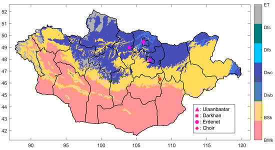
Figure 2.
Locations of ground measurement sites. Climate classification is abbreviated as arid, desert, and cold (BWk); arid, steppe, and cold (BSk); cold, dry winter, and warm summer (Dwb); cold, dry winter, and cold summer (Dwc); cold, no dry season, and warm summer (Dfb); cold, no dry season, and cold summer (Dfc); and polar and tundra (ET).

Table 1.
Details of ground weather stations.
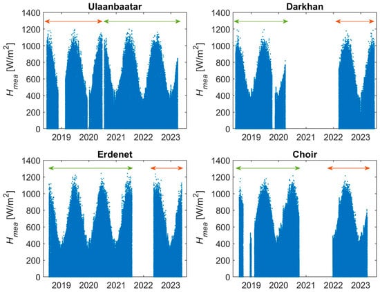
Figure 3.
Long-term measurement campaign where data are separated into parameter estimation and test sets, indicated by green and orange lines, respectively. White blank space represents the period of no measurement recording.
As shown in Figure 4, global irradiance is measured by the Hukseflux CHF-SR11 pyranometer, which is a class B spectrally flat pyranometer with a sensitivity coefficient of 10–40 mV/(kW/m2) [31]. The frequency of data retrieval is set to 1 min and 10 min. The latter is used for comparative analysis between the estimation and measurement following the time granularity of the satellite data, which are recorded every 10 min. On the other hand, data recorded with a high frequency illustrate ramp events caused by sudden changes in the atmosphere that cannot be detected within the observation schedule of the satellite.
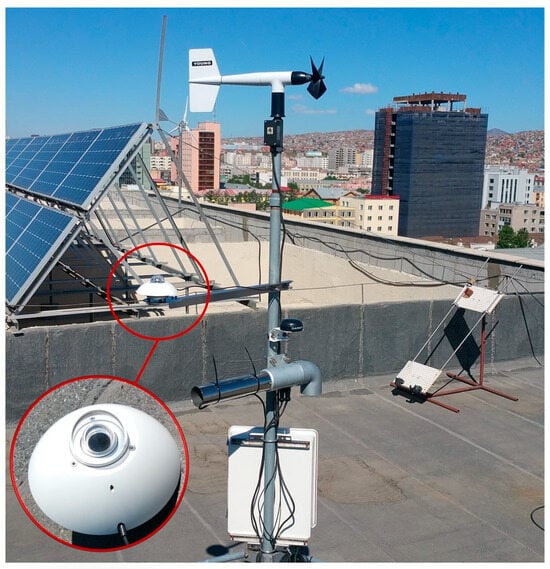
Figure 4.
Weather station located at the Ulaanbaatar site. The pyranometer is zoomed in for a better view.
Because ground sites are not equipped with an albedometer, we employed different sources for ground albedo, namely, monthly averages provided by Gira et al. based on the long-term measurement conducted between 1964 and 1980 [11] and global daily albedo products estimated from the Moderate Resolution Imaging Spectroradiometer (MODIS) aboard the Aqua and Terra satellites [32]. Considering their difference in spatiotemporal resolution and retrieval method, we would select the one that results in the lowest error metrics later by implementing each in the proposed model, as in Section 4.1. On the one hand, since the ground surface is relatively stable compared to the more turbulent atmosphere, the monthly ground albedo provided by Gira et al. [11] could be sufficient for the current study. However, it has been outdated for over 40 years, and the data are available for the Ulaanbaatar site only. For other sites, the nearest albedometer stations are 101 km, 60 km, and 216 km from Darkhan, Erdenet, and Choir, respectively, and we use it as it is. As a result, Figure 5 shows the representative monthly ground albedo for our sites where a seasonal change in ground reflectance is apparent, as it increases in winter due to the snow cover. Moreover, the monthly variation is slightest at the Choir site because of less snowfall in winter and more dust coverage in summer due to its arid and cold desert climate. On the other hand, more frequent observation enables the detection of changes at ground level, which might benefit radiation budget approximation. With that in mind, daily albedo products with a grid spacing of 0.05 degrees provided by MCD43C3 [32] are investigated. They are estimated from the satellite data of 16 days, with the day of interest in the middle. Also, two subgroups assume the sky is either black or white. While the white sky albedo (WSA) assumes a completely diffuse illumination caused by the reflection of incoming irradiance under cloud presence, the black sky albedo (BSA) accounts for a clear sky for which the direct irradiance is only reflected by the ground surface. Moreover, broadbands are considered separately in the visible (0.3–0.7 µm) and shortwave (0.3–5.0 µm) range. Therefore, five different sources of albedo are examined in this study, including monthly ground albedo from the long-term ground measurement and the daily estimated white and black sky albedo product in the visible and shortwave range. To compare them, MODIS MCD43C3 daily albedo products are averaged monthly and shown against the long-term monthly average, as in Figure 6. A large difference between them shows that all estimated products were systematically lower than the long-term average, especially in winter. Although the BSA in the shortwave range appears closer to the long-term database, it does not significantly differ from other products. On that account, the appropriate source for ground albedo should be chosen after testing each of them individually.
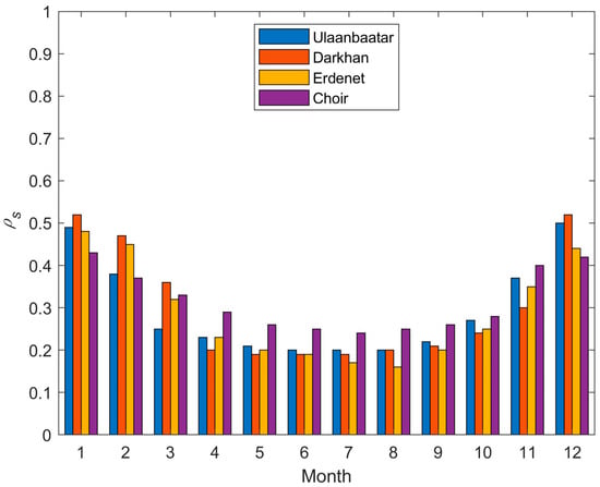
Figure 5.
Representative values of monthly ground albedo from long-term ground measurement database.
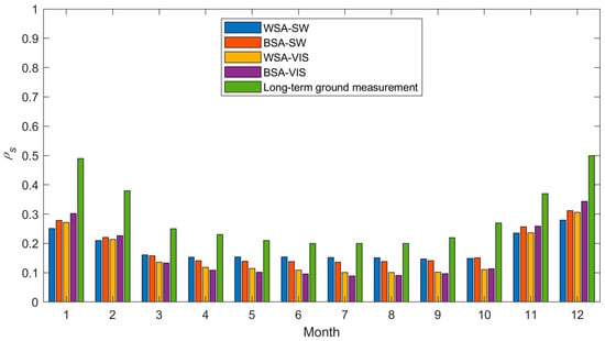
Figure 6.
Estimated and long-term average monthly ground albedo at the Ulaanbaatar site. The abbreviations are white sky albedo (WSA), black sky albedo (BSA), shortwave (SW), and visible (VIS).
4. Discussion
4.1. Input Selection
In addition to selecting the most appropriate ground albedo, as mentioned in Section 3.2, the optimal pixel for ground sites should be determined. This is because even though the spatiotemporal resolution of the satellite data provided by Himawari 8/9 is significantly high compared to its predecessors, it cannot avoid uncertainties and errors altogether. While it seems reasonable to select the pixel denoted as central in Figure 7 as a result of georeferencing, considering the intrinsic error of the satellite sensor, neighboring pixels and their average should be tested as well [33]. Hence, the proposed model is tested 50 times by receiving different combinations of satellite pixel and ground albedo data as inputs. As a result, we conclude that the combination of the northwest pixel of the satellite data and long-term average monthly ground albedo would be the optimal set of inputs because, as shown in Table 2, they resulted in the lowest error metrics at three of the ground sites.

Figure 7.
Sample planetary albedo data recorded at 00:00 in UTC (08:00 local time) on 1 August 2018 to illustrate the optimal pixel selection from Himawari 8/9 observation for ground weather stations. As an example, the 3-by-3 pixel block surrounding the Ulaanbaatar site is zoomed in where N, W, E, C, and S stand for north, west, east, central, and south pixels, respectively.
Table 2.
Selection of input data resulting in the lowest error metrics at ground sites.
To measure the effect of different satellite pixels, it is set as the only variable using the long-term monthly ground albedo data. Selecting the northwest over the center pixel reduced the RMSE by 10.76 W/m2 and 4.09 W/m2 for Ulaanbaatar and Choir sites. Also, when compared against the average of neighboring pixels, the RMSE is improved by 5.76 W/m2, 2.39 W/m2, and 0.79 W/m2 for Ulaanbaatar, Darkhan, and Choir, respectively. Similarly, to evaluate how the ground albedo affects the model performance, the satellite georeferencing is set to use the northwest pixel, and the ground albedo is retrieved from different sources. Using the long-term monthly ground albedo data over albedo products from the MCD43C3 decreased the RMSE by 0.34–4.38 W/m2 for all sites except Ulaanbaatar.
Although error metrics are compromised for the Erdenet site under the optimal setting, the performance of the proposed model at other sites stayed the same or improved, as shown in Table 3 in Section 4.3. The superior performance of the northwest pixel is partly due to the calibration error in high latitudes where the viewing angle increases. Also, as discussed by A. Zelenka et al. in [33], the pixel located next to the central pixel in the direction of the dominant wind, in our case, the northwest pixel, describes the ground condition better. Because the satellite observation is recorded with a frequency of 10 min, there is no information on events that occurred in between, such as the cloud movement in the direction towards the central pixel caused by the wind. In addition, applying the monthly average ground albedo resulted in a slightly better estimation of the surface irradiation. This shows that despite the distance of up to 200 km and the lower temporal resolution, the ground measurement provides more accurate information about the ground surface than the estimation.
4.2. Variation and Distribution of Model Parameters
The optimal values of the model parameters for every pair of incoming satellite data and the corresponding ground measurement during the model development phase are configured in the LUT. As shown in Figure 8, the rows and columns of the LUT are satellite data and solar zenith angles with an increment of 0.1 and 2 degrees, respectively. The cells filled in black indicate that no satellite observation is available when looking for a certain range of planetary albedo and solar position. For example, the input satellite data do not exceed 0.8 at the Erdenet site unless the solar zenith angle is between 28 and 30 degrees.
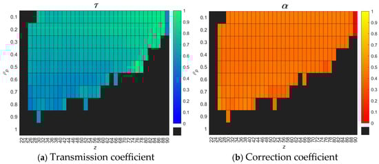
Figure 8.
LUT of optimized model parameters based on the data for parameter estimation at the Erdenet site.
Because similar trends were observed at all ground sites, the Erdenet site is presented as a sample where the parameter estimation data covers three years from 18 July 2018 to 29 July 2021, which forms 75% of the available data measured at this site. As illustrated in Figure 8a, blue and green color gradients exhibit lower and higher transmission, respectively. It was observed that the transmission decreases towards the higher planetary albedo along the vertical axis and lower zenith angle when the sun is high in the sky. The authors assume that the reduced atmospheric transmission is due to the presence of clouds, for which its brightness is recorded as a higher reading in satellite observation. Conversely, a greater transmission is usually found at lower satellite data values, representing a clear sky because the atmosphere is free from highly reflective clouds. On the other hand, no significant gradient is observed for the correction coefficient, as in Figure 8b. Nevertheless, it should be noted that when the zenith angle is high around sunrise and sunset, the incoming satellite data are corrected to account for the very low irradiance condition by setting the correction coefficient to near zero.
In addition, Figure 9 shows the probability density function (PDF) of the model parameters. Because the atmospheric transmittance changes according to the sky condition, a threshold of 0.625 is chosen to classify the sky as clear when τ is greater than 0.625 and cloudy otherwise. It was found that the normal distribution best describes the variation within each class, such as the occurrence of cloudy conditions is more frequent than that of the clear sky. On the contrary, the variation of the correction coefficient α can be well expressed by the kernel distribution since it accounts for the less frequent cases as well, such as sunrise and sunset around the origin of axes.
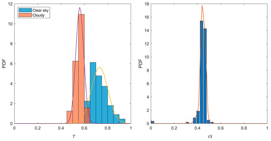
Figure 9.
The distribution of the estimated model parameters at the Erdenet site is shown as histograms. Left: normal distribution lines (purple and yellow) fit to transmission coefficient in cloudy and clear sky scenarios, right: kernel distribution line (orange) fit to correction coefficient.
4.3. Performance Evaluation
The workstation by HPC Tech, Tokyo, Japan implements the proposed methodology with Intel(R) Xeon(R)W-2223 CPU 3.60 GHz and 32 GB RAM. On the software side, IDLE Python 3.11 and MathWorks MATLAB R2023a are used to download satellite data through FTP and to develop the GHI estimation framework, respectively. The average execution time required to process the data of one day in length was 4.5 s for parameter estimation.
The original model by Otani et al. in [19] and JAXA estimated SWR product [28] are selected as baselines because our model is developed based on the former and uses the same raw data as the latter. Similarly to the pixel selection of Himawari 8/9 data, the most representative pixel for ground sites is determined from the neighboring pixels on JAXA SWR data. All ground-measured data were used for the evaluation, and it was found that the northwest pixel best represents the surface insolation for all sites except the Choir site. For these sites, setting the northwest pixel over the central and average of neighboring pixels reduced the RMSE by 6–15 W/m2 and 3–4 W/m2, respectively. This is because the JAXA SWR product is derived from Himawari 8/9 data, for which the northwest pixel is preferred for georeferencing to the ground location.
Table 3 summarizes the performance of the models by evaluating them on the test data set where filtering is applied to exclude nighttime data by setting a threshold of 0 W/m2. Note that it is different from Table 2 because it is not the input set that yields the lowest error metrics for each site but the optimal one, considering all sites. The proposed model outperforms the baseline models in terms of RMSE at all ground sites. Especially the largest improvement is observed at the Ulaanbaatar site, where the RMSE is 13.06 W/m2 and 131.15 W/m2 lower than the original and JAXA SWR products, respectively. For other sites, the improvement was up to 10 W/m2. Regarding the MBE, all methods underestimated the GHI at all sites, which was indicated by negative biases. Nevertheless, the original model gives the lowest MBE except for the Choir site. Unfortunately, that does not mean the estimations are more accurate since the positive and negative biases cancel each other. Therefore, it can be concluded that the performance of the proposed methodology surpasses the baseline models, and the following investigates it in more detail.
Table 3.
Evaluation of the proposed model against baseline models under 10 min timestep.
Table 3.
Evaluation of the proposed model against baseline models under 10 min timestep.
| Model | MBE | RMSE | nMBE | nRMSE | |
|---|---|---|---|---|---|
| Ulaanbaatar | |||||
| Original | −2.81 | 110.58 | 0.92 | −0.76% | 29.88% |
| JAXA SWR | −16.92 | 228.67 | 0.75 | −4.81% | 64.98% |
| Proposed | −11.53 | 97.52 | 0.94 | −3.12% | 26.35% |
| Darkhan | |||||
| Original | −3.05 | 96.35 | 0.94 | −0.87% | 27.44% |
| JAXA SWR | −14.32 | 92.83 | 0.95 | −4.33% | 28.06% |
| Proposed | −6.17 | 90.89 | 0.95 | −1.76% | 25.89% |
| Erdenet | |||||
| Original | −9.16 | 120.22 | 0.90 | −2.64% | 34.70% |
| JAXA SWR | −40.43 | 114.09 | 0.92 | −12.27% | 34.62% |
| Proposed | −10.06 | 113.77 | 0.91 | −2.90% | 32.84% |
| Choir | |||||
| Original | −21.21 | 94.72 | 0.94 | −5.49% | 24.51% |
| JAXA SWR | −17.60 | 90.58 | 0.95 | −4.89% | 25.15% |
| Proposed | −6.51 | 85.51 | 0.95 | −1.69% | 22.12% |
Note: Best error metrics are shown in bold.
The highest and lowest RMSEs are found at the Erdenet and Choir sites with 113.77 W/m2 and 85.51 W/m2, respectively, despite the large amount of data used for parameter estimation at the Erdenet site than Choir. A lesser snowfall at the Choir site could be related to this because it is relatively easier to detect clouds from the visible channel image when the brightness difference is large between the cloud and ground cover. As mentioned earlier, we show results obtained at the Erdenet site as a sample because not only are similar trends observed at all sites, but also the RMSE is highest at this site. Therefore, we can expect slightly better results for other sites. Figure 10 shows the estimation and measurement at the Erdenet site for the test period, which covers 18 May 2022 to 27 May 2023. Along with the 1-by-1 line drawn in red, linear regression is fit to the scatter plot, as shown in green, which in turn shows the overall underestimation, as the green line is below the red line for the majority of data points.
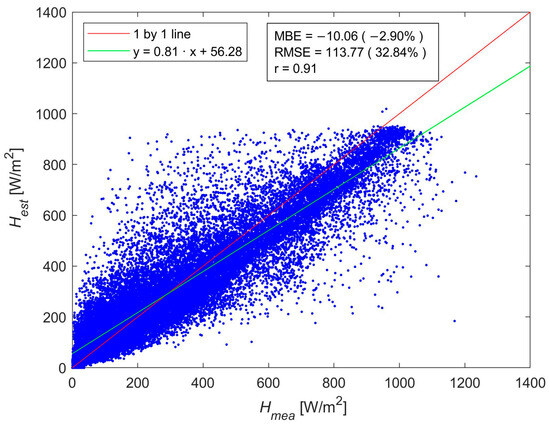
Figure 10.
Estimated vs. measured GHI for the test period at the Erdenet site.
Finally, the monthly performance is investigated in Figure 11 and Table 4. A systematic negative bias is observed in all months except May, June, and July due to underestimating the GHI. On the one hand, the RMSE ranges between 63 and 142 W/m2 where significant errors greater than 90 W/m2 are found in warmer months. But because of the strong solar insolation and increased day length, a larger RMSE does not necessarily convert into a larger nRMSE between March and October [34]. On the other hand, although the RMSE in December was moderate with a value of 76.4 W/m2, the nRMSE was the highest resulting in 47% due to the lower irradiance and decreased day length, which shows the compromise between the RMSE and nRMSE. Additionally, December shows the lowest correlation between the estimation and measurement, where the correlation coefficient is 0.75. The performance degradation in winter can be related to the snow cover. Since snow and clouds are highly reflective in the visible spectrum, it is difficult to distinguish the clouds over snow-covered areas from the satellite image. As a result of this failure, the correlation decreases, and the magnitude of the underestimation increases in the cold season by misinterpreting the snow as a cloud.
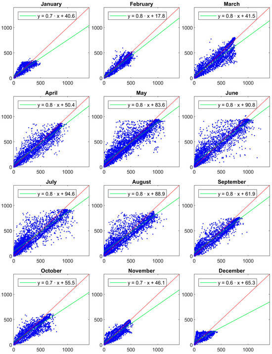
Figure 11.
Monthly comparison between the estimated and measured GHI during the testing period at the Erdenet site. The horizontal and vertical axes represent and in W/m2, respectively. The red lines are 1 by 1 line.
Table 4.
Model performance shown for each month at the Erdenet site.
4.4. Validation Exercise Under Various Sky Conditions
To analyze how the sky condition affects the model performance, the sky condition is classified into clear sky, broken cloud, coexistence, and overcast [35]. Representative days of these classes are selected from the test data set, as shown in Figure 12. On a clear sky condition, the ground truth measurement largely agrees with the estimation despite the slight underestimation in the morning. As a result, a good correlation of 0.97 is found with lower error metrics where the MBE and RMSE were −19 W/m2 and 44 W/m2, leading to percentage errors of −6.4% and 14.9%, respectively. However, a significant difference between the estimation and measurement was observed under the presence of a broken cloud where the MBE and RMSE were 66.6 W/m2 and 136.2 W/m2, respectively. Nevertheless, the model mostly detected the change in the atmospheric condition, which is indicated by the satisfactory correlation of 0.9, considering the limited spatiotemporal resolution of the satellite observation. Since the coexistence condition is a mixture of clear and cloudy sky conditions, the performance was in the middle of those classes. In short, the estimation matches the ground measurement for the clear sky part, but the performance degrades as clouds appear in the cloudy period. Correspondingly, the MBE and RMSE were 49.8 W/m2 and 115.3 W/m2, respectively. Finally, the model performs poorly under an overcast sky where the correlation is 0.75, and percentage errors exceed 100%. Nonetheless, in absolute terms, the discrepancy between the measurement and estimation was lower than that of the broken cloud and coexistence conditions where the MBE and RMSE were 84.3 W/m2 and 102.6 W/m2, respectively. Due to the lower GHI, which mainly consists of the diffuse component of the solar irradiance caused by the thick cloud cover, a slight deviation from the true value induces an even higher percentage error. Moreover, unlike in the case of a clear sky, the model tends to overestimate the GHI in an overcast atmospheric condition.
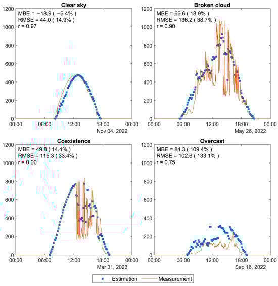
Figure 12.
Model performance on selected days from the testing period at the Erdenet site. The time granularity of the estimation and measurement is 10 min and 1 min, respectively. The vertical axis represents the GHI in W/m2. Correlation of the output error in the estimated GHI concerning input parameters at the Erdenet site.
4.5. Sensitivity Analysis
Lastly, we conducted a sensitivity analysis to investigate the impact of errors included in the input on the output error of the estimated GHI. First, Table 5 lists the correlation coefficient r regarding the output error and each model input where none shows a significant correlation. This highlights that the proposed method is fine-tuned for the estimation task of the GHI. Nevertheless, a weak positive correlation of 0.12 is noticed for the satellite data . Because it is the primary source of input describing the atmospheric and ground states, the estimation error slightly increases towards higher readings of the satellite data, which indicates the presence of highly reflective objects such as clouds and snow.
Table 5.
Correlation of the output error in the estimated GHI concerning input parameters at the Erdenet site.
Secondly, as shown in Figure 13, the influence of input errors on the output error is tracked down by adding an error to each input parameter one at a time. The parameter estimation data set of the Erdenet site are divided into three groups with a length of one year each to which an error of 5%, 10%, and 15% are added intentionally. Data are filtered to remove outliers because they can exceed their theoretical value when adding up errors. Although it was found that the zenith angle is the most sensitive parameter such that a 15% error in it leads to a variation of up to 400 W/m2 on the estimated GHI, it does not necessarily contribute to the output error since it is computed highly accurate by the solar position algorithm [27,36]. Therefore, the transmission coefficient is found to be the most sensitive input parameter where an inclusive error of 15% deviates the output up to 300 W/m2. It should be carefully parameterized because it represents the atmospheric transmittance by modeling the reduction in the extraterrestrial irradiation propagating through the atmosphere. On the other hand, the weight of other inputs is in the same range where an input error of 5% and 15% deviates from the GHI by less than 30 W/m2 and 100 W/m2. Additionally, a seasonal change was apparent for the ground albedo where the same percentage error leads to more variation in the expected output in winter months, especially between December and March, compared to the rest of the year. Because the brightness of snow and cloud cover is high in the visible spectral band, it is difficult to separate the ground and atmospheric conditions from the satellite data in winter, which adds extra uncertainty to the output.
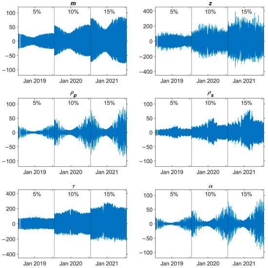
Figure 13.
Sensitivity of the estimated GHI [W/m2] with respect to errors in input parameters at the Erdenet site.
5. Conclusions
In this study, we proposed a semi-empirical model to estimate the GHI using high-resolution visible channel satellite data retrieved from Himawari 8/9 in combination with a limited number of ground measurement sites in arid and cold regions of Mongolia. The local solar climates of the study area are learned through the implementation of site adaptation on the data split for parameter estimation. The data revealed that the combination of the northwest pixel of the satellite data and the long-term average monthly ground albedo as an input data set improved the model performance. Moreover, although the model needs to be parameterized via site adaptation, the study design can be applied to other climates when other satellite and ground measurement data sources are available.
For comparison, the error metrics of the original model proposed by Otani et al. and the JAXA SWR product are also included in the test data. The proposed method outperformed them at all four ground sites with an RMSE of 85–114 W/m2. Especially at the Ulaanbaatar site, the RMSE is improved by 13.06 W/m2 and 131.15 W/m2 from the original and JAXA SWR products, respectively. The lower uncertainty could ease the operation and maintenance of the grid, thus possibly leading to increased reliability and finance.
Nevertheless, a systematic underestimation is observed no matter the model selection, indicated by the negative MBE, which suggests the failure of detecting clouds, especially in winter when the land surface is covered with highly reflective snow. Because clouds affect surface irradiance the most, as shown by the increase in error metrics as clouds appear, future research will be directed toward addressing this issue. The use of the sky camera is promising since it captures local cloud formation with high temporal resolution.
Last but not least, accurate solar irradiance prediction would help the power grid to adapt to the ungovernable nature of solar energy under the assumption of a large PV share in the future energy mix. Although Zhao et al. noted the efficient use of satellite data provided by Himawari 7 for solar forecasting in Inner Mongolia [37], it is still unknown how the high-resolution satellite data of Himawari 8/9 would improve the forecasting skill. Therefore, this guides us in the direction of future research.
Author Contributions
Conceptualization, O.B. and K.O.; methodology, O.B and J.H.; software, O.B.; validation, O.B.; formal analysis, O.B.; investigation, J.H.; resources, K.O.; data curation, O.B. and A.A. (Amarbayar Adiyabat); writing—original draft preparation, O.B.; writing—review and editing, A.A. (Atsushi Akisawa); visualization, O.B.; supervision, A.A. (Atsushi Akisawa); project administration, A.A. (Atsushi Akisawa); funding acquisition, A.A. (Amarbayar Adiyabat). All authors have read and agreed to the published version of the manuscript.
Funding
This research was funded by the Mongolia–Japan Engineering for Education Development (MJEED) project grant number J13A15.
Data Availability Statement
The original data presented in this study are openly available at https://www.eorc.jaxa.jp/ptree/ (accessed on 17 December 2024) and https://ladsweb.modaps.eosdis.nasa.gov/ (accessed on 17 December 2024).
Conflicts of Interest
The authors declare no conflicts of interest.
Nomenclature
| Abbreviations | |
| GHI | global horizontal irradiance |
| PV | photovoltaic |
| IRENA | International Renewable Energy Agency |
| LCOE | levelized cost of electricity |
| STC | standard test conditions |
| MPP | maximum power point |
| ASG | Asian super grid |
| GIS | geographic information system |
| FARMS | Fast All-sky Radiation Model for Solar applications |
| GOES | Geostationary Operational Environmental Satellite |
| NSRDB | National Solar Radiation Database |
| DNI | direct normal irradiance |
| GMS | Geostationary Meteorological Satellite |
| ESRA | European Solar Radiation Atlas |
| MSG | Meteosat Second Generation |
| IR | infrared |
| RMSE | root mean square error |
| MBE | mean bias error |
| LUT | lookup table |
| nRMSE | normalized root mean square error |
| nMBE | normalized mean bias error |
| JAXA | Japan Aerospace Exploration Agency |
| AHI | advanced Himawari imager |
| MTSAT | multi-functional transport satellite |
| RGB | red, green, and blue |
| PAR | photosynthetically active radiation |
| SWR | shortwave radiation |
| UTC | coordinated universal time |
| MODIS | Moderate Resolution Imaging Spectroradiometer |
| WSA | white sky albedo |
| BSA | black sky albedo |
| SW | shortwave |
| VIS | visible |
| probability density function | |
| Notations | |
| IV | current–voltage |
| estimated global horizontal irradiance | |
| measured global horizontal irradiance | |
| transmission coefficient | |
| correction coefficient | |
| planetary albedo | |
| ground albedo | |
| airmass | |
| solar zenith angle | |
| number of pairs | |
| correlation coefficient | |
| covariance | |
| BWk | arid, desert, and cold |
| BSk | arid, steppe, and cold |
| Dwb | cold, dry winter, and warm summer |
| Dwc | cold, dry winter, and cold summer |
| Dfb | cold, no dry season, and warm summer |
| Dfc | cold, no dry season, and cold summer |
| ET | polar and tundra |
References
- International Solar Energy Society (ISES). Online Solar Energy Museum. Available online: https://www.ises.org/what-we-do/ises-online-museum-solar-energy (accessed on 11 October 2024).
- International Renewable Energy Agency (IRENA). Renewable Power Generation Costs in 2021; Available online: https://www.irena.org/-/media/Files/IRENA/Agency/Publication/2022/Jul/IRENA_Power_Generation_Costs_2021_Summary.pdf (accessed on 17 December 2024).
- National Renewable Energy Laboratory (NREL). Best Research-Cell Efficiency Chart. Available online: https://www.nrel.gov/pv/cell-efficiency.html (accessed on 11 October 2024).
- REN21. Renewables Global Status Report; 2023; Available online: https://www.ren21.net/gsr-2023/ (accessed on 17 December 2024).
- PV Education. The Effect of Temperature on the IV Characteristics of a Solar Cell. Available online: https://www.pveducation.org/pvcdrom/solar-cell-operation/effect-of-temperature (accessed on 11 October 2024).
- PVsyst. Standard Test Conditions. Available online: https://www.pvsyst.com/help-pvsyst7/stc.htm (accessed on 11 October 2024).
- Komoto, K.; Ito, M.; van der Vleuten, P.; Faiman, D.; Kurokawa, K. Energy from the Desert; Earthscan: New York, NY, USA, 2009. [Google Scholar]
- Geology.com. The World’s Largest Deserts. Available online: https://geology.com/records/largest-desert.shtml (accessed on 11 October 2024).
- International Renewable Energy Agency (IRENA). Mongolia-Renewables Readiness Assessment; 2016; Available online: https://www.irena.org/-/media/Files/IRENA/Agency/Publication/2016/IRENA_RRA_Mongolia_2016.pdf (accessed on 17 December 2024).
- Mano, S.; Ovgor, B.; Samadov, Z.; Pudlik, M.; Julch, V.; Sokolov, D.; Yoon, J.Y. Gobitec and Asian Super Grid for Renewable Energies in Northeast Asia; 2014; Available online: https://www.energycharter.org/fileadmin/DocumentsMedia/Thematic/Gobitec_and_the_Asian_Supergrid_2014_en.pdf (accessed on 17 December 2024).
- Gira, Y. Solar Cadastre of Mongolia; Information and Research Institute of Meteorology, Hydrology and Environment; Ulaanbaatar, Mongolia, 1985. [Google Scholar]
- Adiyabat, A.; Kurokawa, K.; Otani, K.; Enebish, N.; Batsukh, G.; Battushig, M.; Ochirvaani, D.; Ganbat, B. Evaluation of solar energy potential and PV module performance in the Gobi Desert of Mongolia. Prog. Photovolt. Res. Appl. 2006, 14, 553–566. [Google Scholar] [CrossRef]
- Batdelger, D. Solar Radiation Atlas of Mongolia; Mongolian Academy of Sciences: Ulaanbaatar, Mongolia, 2010. [Google Scholar]
- Sengupta, M.; Habte, A.; Wilbert, S.; Gueymard, C.; Remund, J. Best Practices Handbook for the Collection and Use of Solar Resource Data for Solar Energy Applications, 3rd ed.; National Renewable Energy Laboratory (NREL): Golden, CO, USA, 2021. Available online: https://www.nrel.gov/docs/fy21osti/77635.pdf (accessed on 17 December 2024).
- Xie, Y.; Sengupta, M.; Dudhia, J. A Fast All-sky Radiation Model for Solar applications (FARMS): Algorithm and performance evaluation. Sol. Energy 2016, 135, 435–445. [Google Scholar] [CrossRef]
- Letu, H.; Yang, K.; Nakajima, T.Y.; Ishimoto, H.; Nagao, T.M.; Riedi, J.; Baran, A.J.; Ma, R.; Wang, T.; Shang, H.; et al. High-resolution retrieval of cloud microphysical properties and surface solar radiation using Himawari-8/AHI next-generation geostationary satellite. Remote Sens. Environ. 2020, 239, 111583. [Google Scholar] [CrossRef]
- Huang, C.; Shi, H.; Yang, D.; Gao, L.; Zhang, P.; Fu, D.; Xia, X.; Chen, Q.; Yuan, Y.; Liu, M.; et al. Retrieval of sub-kilometer resolution solar irradiance from Fengyun-4A satellite using a region-adapted Heliosat-2 method. Sol. Energy 2023, 264, 112038. [Google Scholar] [CrossRef]
- Perez, R.; Ineichen, P.; Moore, K.; Kmiecik, M.; Chain, C.; George, R.; Vignola, F. A new operational model for satellite-derived irradiances: Description and validation. Sol. Energy 2002, 73, 307–317. [Google Scholar] [CrossRef]
- Otani, K.; Kurokawa, K.; Tsuda, I.; Saitoh, T.; Horigome, T. Estimation of ground albedo by GMS images for solar irradiation monitoring. Sol. Energy Mater. Sol. Cells 1994, 35, 395–400. [Google Scholar] [CrossRef]
- Han, J.Y.; Vohnicky, P. An optimized approach for mapping solar irradiance in a mid-low latitude region based on a site-adaptation technique using Himawari-8 satellite imageries. Renew. Energy 2022, 187, 603–617. [Google Scholar] [CrossRef]
- Alonso-Montesinos, J.; Batlles, F.J.; Bosch, J.L. Beam, diffuse and global solar irradiance estimation with satellite imagery. Energy Convers. Manag. 2015, 105, 1205–1212. [Google Scholar] [CrossRef]
- Escobar, R.A.; Cortes, C.; Pino, A.; Pereira, E.B.; Martins, F.R.; Cardemil, J.M. Solar energy resource assessment in Chile: Satellite estimation and ground station measurements. Renew. Energy 2014, 71, 324–332. [Google Scholar] [CrossRef]
- World Bank. Climate Change Knowledge Portal. Available online: https://climateknowledgeportal.worldbank.org/ (accessed on 11 October 2024).
- Molina, A.; Falvey, M.; Rondanelli, R. A solar radiation database for Chile. Sci. Rep. 2017, 7, 14823. [Google Scholar] [CrossRef] [PubMed]
- Damiani, A.; Irie, H.; Horio, T.; Takamura, T.; Khatri, P.; Takenaka, H.; Nagao, T.; Nakajima, T.Y.; Cordero, R.R. Evaluation of Himawari-8 surface downwelling solar radiation by ground-based measurements. Atmos. Meas. Tech. 2018, 11, 2501–2521. [Google Scholar] [CrossRef]
- Gueymard, C.A.; Lara-Fanego, V.; Sengupta, M.; Xie, Y. Surface albedo and reflectance: Review of definitions, angular and spectral effects, and intercomparison of major data sources in support of advanced solar irradiance modeling over the Americas. Sol. Energy 2019, 182, 194–212. [Google Scholar] [CrossRef]
- National Oceanic and Atmospheric Administration (NOAA), Global Monitoring Division. General Solar Position Calculations. Available online: https://gml.noaa.gov/grad/solcalc/solareqns.PDF (accessed on 11 October 2024).
- Japan Aerospace Exploration Agency (JAXA). Himawari Monitor P-Tree. Available online: https://www.eorc.jaxa.jp/ptree/ (accessed on 11 October 2024).
- Bessho, K.; Date, K.; Hayashi, M.; Ikeda, A.; Imai, T.; Inoue, H.; Kumagai, Y.; Miyakawa, T.; Murata, H.; Ohno, T.; et al. An introduction to Himawari-8/9—Japan’s new-generation geostationary meteorological satellites. J. Meteorol. Soc. Jpn. 2016, 94, 151–183. [Google Scholar] [CrossRef]
- Beck, H.E.; Zimmermann, N.E.; McVicar, T.R.; Vergopolan, N.; Berg, A.; Wood, E.F. Present and future Koppen-Geiger climate classification maps at 1-km resolution. Sci. Data 2018, 5, 180214. [Google Scholar] [CrossRef]
- Climatec. In CHF-SR11/12 Instruction Manual; Tokyo, Japan, 2012.
- National Aeronautics and Space Administration (NASA). Level-1 and Atmosphere Archive Distribution System (LAADS) Distributed Active Archive Center (DAAC). Available online: https://ladsweb.modaps.eosdis.nasa.gov/ (accessed on 11 October 2024).
- Zelenka, A.; Perez, R.; Seals, R.; Renne, D. Effective Accuracy of Satellite-Derived Hourly Irradiances. Theor. Appl. Climatol. 1999, 62, 199–207. [Google Scholar] [CrossRef]
- Nouri, B.; Blum, N.; Wilbert, S.; Zarzalejo, L.F. A Hybrid Solar Irradiance Nowcasting Approach: Combining All Sky Imager Systems and Persistence Irradiance Models for Increased Accuracy. Sol. RRL 2022, 6, 2100442. [Google Scholar] [CrossRef]
- Takenaka, H.; Nakajima, T.Y.; Higurashi, A.; Higuchi, A.; Takamura, T.; Pinker, R.T.; Nakajima, T. Estimation of solar radiation using a neural network based on radiative transfer. J. Geophys. Res. Atmos. 2011, 116, 13. [Google Scholar] [CrossRef]
- Yang, J.; Kim, J.H.; Jimenez, P.A.; Sengupta, M.; Dudhia, J.; Xie, Y.; Golnas, A.; Giering, R. An efficient method to identify uncertainties of WRF-Solar variables in forecasting solar irradiance using a tangent linear sensitivity analysis. Sol. Energy 2021, 220, 509–522. [Google Scholar] [CrossRef]
- Zhao, S.; Wu, L.; Xiang, Y.; Dong, J.; Li, Z.; Liu, X.; Tang, Z.; Wang, H.; Wang, X.; An, J.; et al. Coupling meteorological stations data and satellite data for prediction of global solar radiation with machine learning models. Renew. Energy 2022, 198, 1049–1064. [Google Scholar] [CrossRef]
Disclaimer/Publisher’s Note: The statements, opinions and data contained in all publications are solely those of the individual author(s) and contributor(s) and not of MDPI and/or the editor(s). MDPI and/or the editor(s) disclaim responsibility for any injury to people or property resulting from any ideas, methods, instructions or products referred to in the content. |
© 2024 by the authors. Licensee MDPI, Basel, Switzerland. This article is an open access article distributed under the terms and conditions of the Creative Commons Attribution (CC BY) license (https://creativecommons.org/licenses/by/4.0/).