


Journal Menu
► ▼ Journal Menu-
- Remote Sensing Home
- Aims & Scope
- Editorial Board
- Reviewer Board
- Topical Advisory Panel
- Photography Exhibition
- Instructions for Authors
- Special Issues
- Topics
- Sections & Collections
- Article Processing Charge
- Indexing & Archiving
- Editor’s Choice Articles
- Most Cited & Viewed
- Journal Statistics
- Journal History
- Journal Awards
- Society Collaborations
- Conferences
- Editorial Office
Journal Browser
► ▼ Journal BrowserNeed Help?
Announcements
15 December 2020
MDPI adopts C4DISC principles to improve diversity and inclusion in scholarly communications
MDPI is proud to adopt the principles of the Coalition for Diversity & Inclusion in Scholarly Communications (C4DISC) to support building equity, inclusion, diversity, and accessibility in scholarly communications.
The C4DISC represents organizations and individuals working in scholarly communications and is focused on addressing issues of diversity and inclusion within the publishing industry.

MDPI’s Managing Editors encourage the Editors-in-Chief and Associate Editors to appoint diverse expert Editorial Boards. This is also reflective in our multi-national and inclusive workplace. We are proud to create equal opportunities without regard to gender, ethnicity, geographic location, sexual orientation, age, disability, political beliefs, religion, or socio-economic status. There is no place for discrimination in our workplace and editors of MDPI journals are to uphold these principles in high regard.
Representatives from C4DISC meet monthly, and have started to implement initiatives to shed light and improve on the lack of diversity in scholarly communications. Some of the initiatives include developing a joint statement of principles; conducting market research; providing training resources, best practices, toolkits, and documentation for our collective memberships; and establishing outreach programs, curricula, events, and publications.
The Coalition is committed to:
- eliminating barriers to participation, extending equitable opportunities across all stakeholders, and ensuring that our practices and policies promote equitable treatment and do not allow, condone, or result in discrimination;
- creating and maintaining an environment that respects diverse traditions, heritages, and experiences;
- promoting diversity in all staff, volunteers, and audiences, including full participation in programs, policy formulation, and decision-making;
- raising awareness about career opportunities in our industries to groups who are currently underrepresented in the workforce;
- supporting our members in achieving diversity and inclusion within their organizations.
14 December 2020
Article Layout and Templates Revised for Future Volumes
At MDPI we have slightly revised the layout for articles to be published in the 2021 Volume, starting at the end of December 2020. As of today, the article templates available for download on ‘Instructions for Authors’ pages have been updated.
The most noticeable change can be found on the first page of the article, where a left-hand column has been created to include the following front matter elements: (i) the recommended citation style for the article, (ii) the publishing history, (iii) as well as the Creative Commons Attribution license used (iv) a standard note regarding affiliations. At the same time, the extra spacing on the left means the authors’ affiliations are now more clearly set apart than before. Other front matter key elements such as journal logo, article type, article title, authors, abstract and keywords remain unchanged.
The blank column on the left runs through all pages in an article; as a result, the main text is slightly more condensed, which improve reader friendliness for smaller screens. Small figures/tables are aligned on the left with standard indenture, while large figures/tables are centered and covering the full width of the page. The revised layout was applied in the article pictured below, to serve as an example:
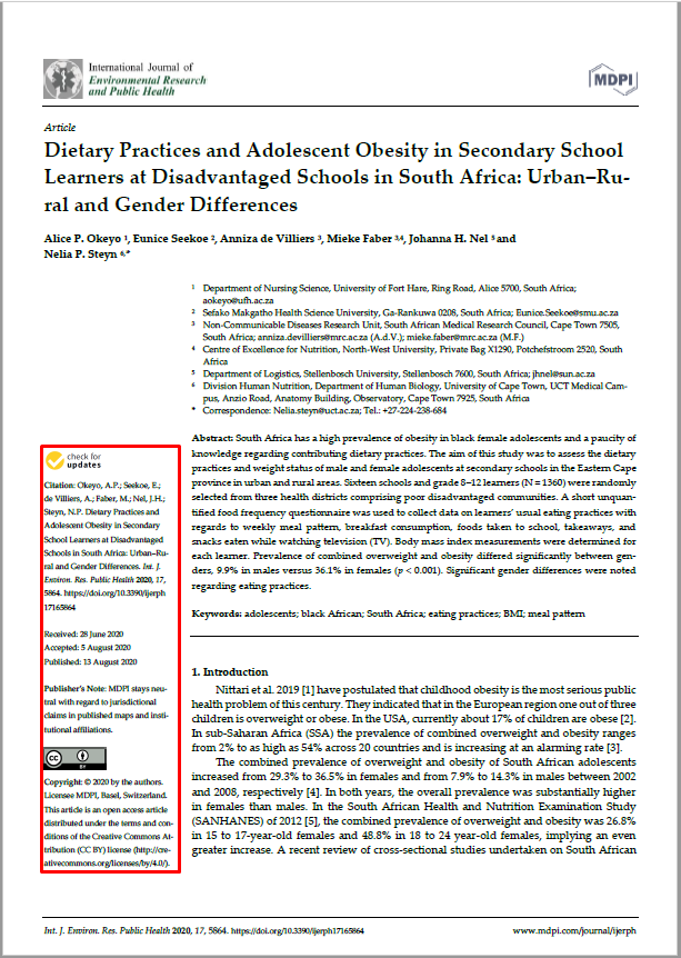
1) Information is displayed in the left information bar.
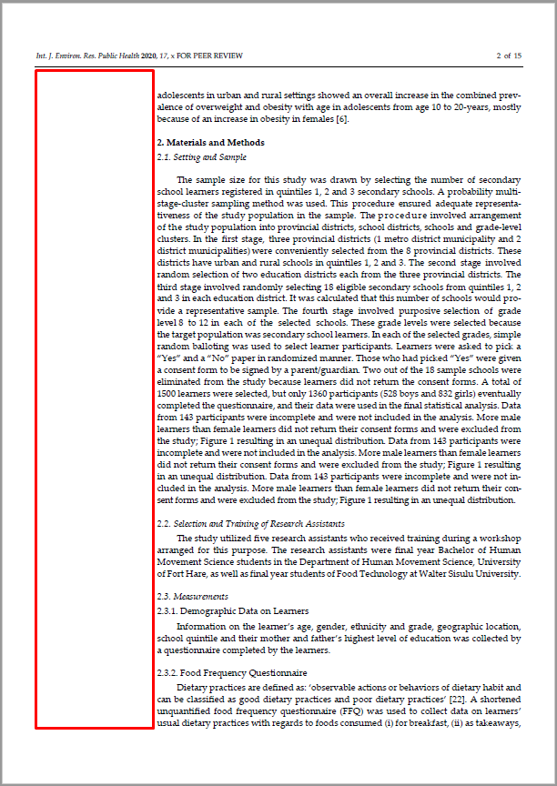
2) In the main text, there is a blank column on the left.
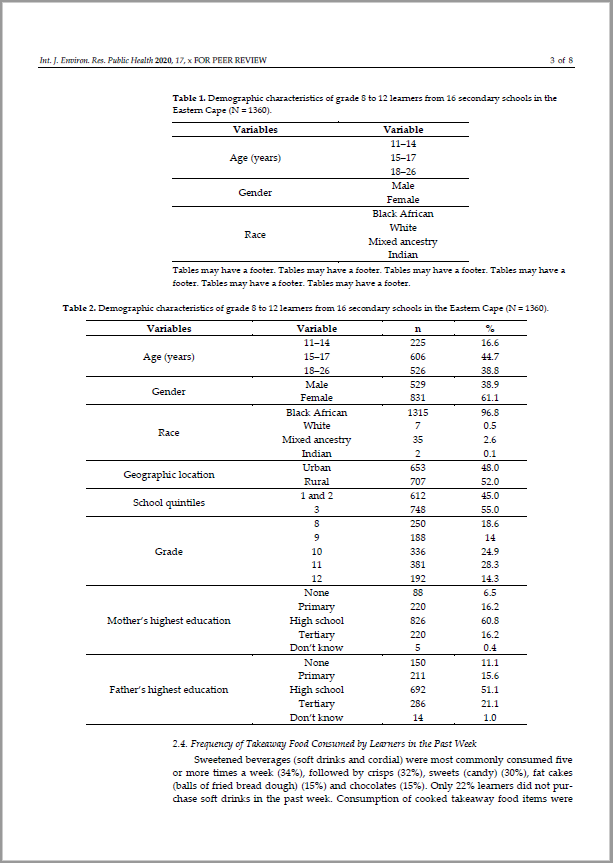
3) Small tables/figures are aligned on the left, large tables/figures are centered.
11 December 2020
2020 "Highly Cited Researchers" on MDPI Journal's Editorial Boards
We are pleased to acknowledge that many academic editors who have made an impact on MDPI journals as editorial board members, editors-in-chief, or section editors, are recognized as 2020 Highly Cited Researchers by Clarivate.
Highly Cited Researchers highlights the top 1% of researchers, by citations, in one or more of the 22 fields used in Clarivate Analytics Essential Science Indicators. We offer our congratulations to 279 academic editors of MDPI journals who were recognized as the most influential scholars in their fields in 2020.
Adams, Dave Agarwal, Ravi P. Ahn, Choon Ki Ahn, Myung-Ju Albrecht, Randy A. Andersson, Dan I. Anker, Stefan D. Apergis, Nicholas Ariga, Katsuhiko Artaxo, Paulo Balsamo, Gianpaolo Barba, Francisco J. Benediktsson, Jon Atli Benelli, Giovanni Bhatnagar, Amit Bialystok, Ellen Blaabjerg, Frede Blay, Jean-Yves Bogers, Marcel Bolton, Declan J. Boyer, Cyrille Brocca, Luca Bruix, Jordi Buhalis, Dimitrios Burdick, Jason A. Byrd, John C. Cabeza, Luisa F. Cabrerizo-Lorite, Francisco Javier Cai, Jianchao Calhoun, Vince D. Cantu, Robert C. Cerqueira, Miguel Chang, Jo-Shu Chau, Kwok-wing Chemat, Farid Chen, Jianmin Chen, Jun Chen, Min Chen, Shaowei Chen, Wei Chen, Wei-Hsin Chen, Xiaofeng Chen, Yangkang Chen, Zhi-Gang Chiclana, Francisco Corella, Dolores Cortes, Javier Cortes, Jorge Cummings, Kenneth Michael Dai, Shifeng Decker, Eric A. DePinho, Ronald A. Dimopoulos, Meletios-Athanasios Dincer, Ibrahim Du, Yihong Dupont, Didier Edwards, David Ellahi, Rahmat Ellis, Erle C. ElMasry, Gamal Esteller, Manel Estruch, Ramón Fang, Chuanglin Fasano, Alessio Fernandez-Lafuente, Roberto Ferreira, Isabel Fortino, Giancarlo Galluzzi, Lorenzo Galvano, Fabio Gandomi, Amir H. Gandomi, Amir H. Gao, Bin Gao, Feng Gao, Wei Garbe, Claus García, Hermenegildo Geschwind, Daniel H. Giampieri, Francesca Giralt, Sergio A. Glanz, Karen Goldewijk, Kees Klein Gössling, Stefan Govindan, Kannan Granato, Daniel Grosso, Giuseppe Grosso, Giuseppe Guerrero, Josep M. Haase, Dagmar Hagger, Martin S. Hamblin, Michael R. Han, Heesup Jankovic, Joseph Janotti, Anderson |
Jiang, Hai-Long Kalaji, Hazem M. Kalantar-Zadeh, Kourosh Kaner, Richard B. Karimi, Hamid Reza Kataoka, Kazunori Keesstra, Saskia Kepp, Oliver Kerminen, Veli-Matti Keyzers, Robert A. Khademhosseini, Ali Khan, Nafees A. Kim, Ki-Hyun Klemeš, Jiří Jaromír Klenk, Hans-Peter Konopleva, Marina Y. Krammer, Florian Krebs, Frederik C. Kroemer, Guido Kudo, Masatoshi Kurths, Juergen Kurzrock, Razelle Kuznetsov, Nikolay V. Kyrpides, Nikos C. La Vecchia, Carlo Lai, Yuekun Lam, James Lancellotti, Patrizio Lee, Sangmoon Leung, Victor C. M. Li, Jinghong Li, Yurui Lindahl, José M. Merigó Lip, Gregory Y. H. Loh, Xian Jun Long, Hualou Lund, Henrik Luo, Jingshan Luque, Rafael Lyons, Timothy W. Ma, Jun Ma, Wen-Xiu Ma, Yanming Maeda, Keisuke Makarova, Kira Mantovani, Alberto Martín-Belloso, Olga Martinoia, Enrico Marzband, Mousa Masclaux-Daubresse, Celine Masson, Patrick Mateos, María Victoria Mathiesen, Brian Vad Matyjaszewski, Krzysztof McArthur, Grant A. McCauley, Darren Medlock, Jolyon M. Melero, Ignacio Mezzetti, Bruno Miroshnichenko, Andrey E. Moran, Daniel Mueller, Lukas A. Mueller-Roeber, Bernd Naushad, Mu Nemeroff, Charles B. Nieto, Juan J. O'Donnell, Colm Ogino, Shuji Olabi, Abdul-Ghani O'Regan, Donal Orsini, Nicola Oswald, Isabelle P. Ozcan, Aydogan Pahl-Wostl, Claudia Pang, Huan Payne, James E. Peng, Shushi Perc, Matjaz Perez-Alvarez, Jose Angel Piquero, Alex R. Ploss, Alexander Postolache, Mihai Pradhan, Biswajeet Prinsep, Michele R. Qian, Dong Qu, Xiaogang Reiter, Russel J. Riahi, Keywan Richter, Andreas Rignot, Eric Robert, Caroline Ros, Emilio Rosell, Rafael |
Rosen, Marc A. |
The full list of 2020 Highly Cited Researchers can be accessed on https://recognition.webofsciencegroup.com/awards/highly-cited/2020/
--- Highly Cited Researchers (HCR) is a Clarivate product.
10 December 2020
Satellite-Based Machine Learning Model for Mapping Pollution in the UK Published in Remote Sensing
The article entitled "A Satellite-Based Spatio-Temporal Machine Learning Model to Reconstruct Daily PM2.5 Concentrations across Great Britain", co-authored by Guest Editor Dr Itai Kloog, was published in the Remote Sensing Special Issue The Use of Earth Observations for Exposure Assessment in Epidemiological Studies has been discussed in various media outlets. Dr Rochelle Schneider and her team aimed to develop a multi-stage satellite-based technique that uses artificial intelligence to estimate daily fine particulate matter (PM2.5) levels across Great Britain during 2008–2018.
In their press release entitled "AI-driven map could link UK air quality to health”, The Engineer declared that "the output reveals the shifting patterns of air pollution across Great Britain and in time with extraordinary detail. We now hope to use this information to better understand how pollution is affecting the nation’s health, so we can take steps to minimize the risk. The vast amount of data produced will provide a vital tool for public health researchers investigating the effects of air pollution". As first author of the article, Dr Rochelle Schneider said in the interview, "this research uses the power of artificial intelligence to advance environmental modelling and address public health challenges".
"This study demonstrates how cutting-edge techniques based on artificial intelligence and satellite technologies can benefit public health research," according to Antonio Gasparrini, Professor of Biostatistics and Epidemiology at LSHTM and senior author of the study.
Mirage News announced it as "a novel method that combines artificial intelligence with remote sensing satellite technologies has produced the most detailed coverage of air pollution in Britain to date." (https://www.miragenews.com/artificial-intelligence-and-satellite-technologies-reveal-detailed-map-of-air-pollution-across-great-britain/)
The report included an interview with Dr Vincent-Henri Peuch, Director of Copernicus Atmosphere Monitoring Service (CAMS) at European Centre for Medium-Range Weather Forecasts (ECMWF), who declared “this innovative method has combined the strengths of different data sources to give accurate and comprehensive estimates of air pollution exposure, including ground-based sensors, satellite data, and model reanalyses developed by ECMWF as part of the EU Copernicus programme. Dr Schneider and co-authors convincingly demonstrate its performance over Great Britain, paving the way for many future studies into the health effects of air pollution”.
Dr Pierre-Philippe Mathieu, Head of the Phi-lab Explore Office at the European Space Agency (ESA), said "it’s exciting to see data from Earth observation satellites being used in public health research to advance our understanding of the intricate relationship between health and air quality, improving lives in Great Britain, Europe and the rest of the world".
Remote Sensing (ISSN 2072-4292, IF 4.509) is a peer-reviewed open access journal on the science and application of remote sensing technology, and is published semi-monthly online by MDPI. Remote Sensing publishes regular research papers, reviews, letters, and communications covering all aspects of remote sensing science, from sensor design and validation/calibration to its application in geosciences, environmental sciences, ecology, and civil engineering. Its aim is to publish novel/improved methods/approaches and/or algorithms of remote sensing to benefit the community, open to anyone in need of them.
7 December 2020
Article from London School of Hygiene and Tropical Medicine (LSHTM) about a new technology that uses satellite data to map British air quality published in Remote Sensing
An article entitled “A Satellite-Based Spatio-Temporal Machine Learning Model to Reconstruct Daily PM2.5 Concentrations across Great Britain”, co-authored by Guest Editor Dr Itai Kloog, was published in the Remote Sensing Special Issue The Use of Earth Observations for Exposure Assessment in Epidemiological Studies on November 20, 2020, and has already been shared by numerous media outlets.
Dr Rochelle Schneider and her team aimed to develop a multi-stage satellite-based technique that uses artificial intelligence to estimate daily fine particulate matter (PM2.5) levels across Great Britain during 2008–2018.
In their press release entitled “AI-driven map could link UK air quality to health”, published on the same day as the article, The Engineer declared that “the output reveals the shifting patterns of air pollution across Great Britain and in time with extraordinary detail. We now hope to use this information to better understand how pollution is affecting the nation’s health, so we can take steps to minimize the risk. The vast amount of data produced will provide a vital tool for public health researchers investigating the effects of air pollution”.
As first author of the article, Dr Rochelle Schneider said in the interview, “this research uses the power of artificial intelligence to advance environmental modelling and address public health challenges”.
“This study demonstrates how cutting-edge techniques based on artificial intelligence and satellite technologies can benefit public health research,” according to Antonio Gasparrini, Professor of Biostatistics and Epidemiology at LSHTM and senior author of the study.
Mirage News announced it as “a novel method that combines artificial intelligence with remote sensing satellite technologies has produced the most detailed coverage of air pollution in Britain to date.” (https://www.miragenews.com/artificial-intelligence-and-satellite-technologies-reveal-detailed-map-of-air-pollution-across-great-britain/)
The report included an interview with Dr Vincent-Henri Peuch, Director of Copernicus Atmosphere Monitoring Service (CAMS) at European Centre for Medium-Range Weather Forecasts (ECMWF), who declared “this innovative method has combined the strengths of different data sources to give accurate and comprehensive estimates of air pollution exposure, including ground-based sensors, satellite data, and model reanalyses developed by ECMWF as part of the EU Copernicus programme. Dr Schneider and co-authors convincingly demonstrate its performance over Great Britain, paving the way for many future studies into the health effects of air pollution”.
Dr Pierre-Philippe Mathieu, Head of the Phi-lab Explore Office at the European Space Agency (ESA), said “it’s exciting to see data from Earth observation satellites being used in public health research to advance our understanding of the intricate relationship between health and air quality, improving lives in Great Britain, Europe and the rest of the world”.
Remote Sensing (ISSN 2072-4292, IF 4.509) is a peer-reviewed open access journal on the science and application of remote sensing technology, and is published semi-monthly online by MDPI. Remote Sensing publishes regular research papers, reviews, letters, and communications covering all aspects of remote sensing science, from sensor design and validation/calibration to its application in geosciences, environmental sciences, ecology, and civil engineering. Its aim is to publish novel/improved methods/approaches and/or algorithms of remote sensing to benefit the community, open to anyone in need of them.
30 November 2020
Welcome to Read Selected Papers from “Editor’s Choice”
Since it was established, “Editor’s Choice” has always been welcomed by reseachers. Editors-in-Chief have selected more than 200 papers to display here. All of them have gained significant influence.
In Novemeber 2020, the Editorial Office selectd 15 papers amoung the most downloaded publications. The following is the paper list.
|
Jian Li et al. |
Olli Nevalainen et al. |
|
Jun Xiong et al. |
Jibo Yue et al. |
|
Nathan Torbick et al. |
Ana I. De Castro et al. |
|
Chenyang Cui et al. |
Andromachi Chatziantoniou et al. |
|
Frédéric Frappart et al. |
Emilio Guirado et al. |
|
Urban Land Extraction Using VIIRS Nighttime Light Data: An Evaluation of Three Popular Methods Yinyin Dou et al. |
Survey of Hyperspectral Earth Observation Applications from Space in the Sentinel-2 Context Julie Transon et al. |
|
Yi Peng et al. |
Vasit Sagan et al. |
|
Michele Melchiorri et al. |
|
We would like to take this opportunity to thank all the research groups of the exceptional papers for their contributions to Remote Sensing. We would appreciate it if you would circulate this document among your colleagues or through your network.
If you want to learn more about the contributions published in “Editors’s Choice”, please read here.
15 October 2020
Final Webinars of the EUXDAT Project. How the EUXDAT Infrastructure Can Contribute to the European Green Deal and Destination Earth

Agriculture comprises vital economic sectors producing food, agro-industrial feedstock, and energy and provides environmental services through managing soil, water, air and biodiversity holistically. Agriculture and forestry also contribute to managing and reducing risks from natural disasters such as floods, droughts, mudslides and avalanches. Farming with its close contact to nature provides the socio-economic infrastructure to maintain cultural heritage. Farmers are also conservers of forests, pastures, fallow lands and their natural resources and, in turn, of the environment. Agriculture today is a composite activity involving many actors and stakeholders in agri-food chains that produce and provide food and agricultural commodities to consumers. In addition to farmers there are farm input suppliers, processors, transporters and market intermediaries each playing their roles to make these chains efficient.
The agriculture sector is under the strong influence of a number of different external drivers, which will have more and more influence on all agriculture and food sectors. As main drivers for changes in the agriculture sector the following factors were recognised – climate changes, demographic (growing population, urbanisation and land abandonment), energy cost, new demands on food quality (food quality and safety, aging population and health problems, ethnic and cultural changes), innovative drivers (knowledge based bio economy, research and development, information and communication, education, investment), – policies (subsidies, standardisation and regulation, national strategies for rural development), economy (economical instruments, partnerships, cooperation and integration and voluntary agreements), sustainability and environmental issue (valuation of ecological performances, development of sustainable agriculture), public opinion (press, international organisation, politicians).
These changes are inevitable and many forces conspire to bring them about. The common and future position of each important driver can be different in reality. In many cases, two drivers can stand against each other and their future influence on the agri-production and food market depends on regulations and a common policy.
These topics have become more relevant which is confirmed by the fact that they are strongly addressed in the European Green Deal and in the global scale by the Sustainable Development Goals of the United Nations.
The European Green Deal is a package of European Commission’s measures announced on 11th December 2019 that should ensure citizens and companies in the European Union the transition to a more sustainable and greener economy by 2050.
The Green Deal consists of a set of measures that enhances resource efficiency through the transition to a clean circular economy, prevents biodiversity loss and reduces pollution. These measures are related to following policy areas:
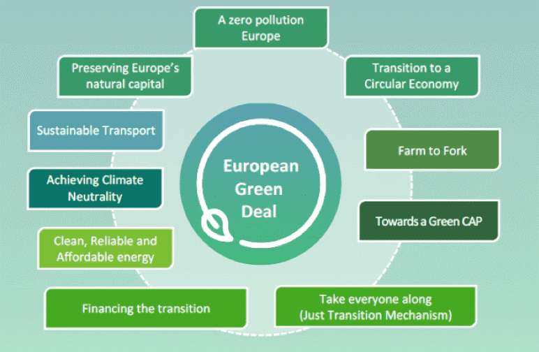
Similarly, this is related to a number of SGD goals of the UN:

Together with publishing the European Green Deal, the Commission is adopting the EU industrial strategy to address the twin challenge of the green and the digital transformation. The goal is to use the potential of the digital transformation, to be a key enabler for reaching the Green Deal objectives. The Commission is planning to initiate a ‘GreenData4All’, with focus on reviewing the Directive establishing an Infrastructure for Spatial Information in the EU (INSPIRE and combining it with the access to the Environment Information Directive). As part of this will be the ‘Destination Earth’ initiative.
“The ‘Destination Earth’ initiative will bring together European scientific and industrial excellence to develop a very high precision digital model of the Earth. This ground-breaking initiative will offer a digital modelling platform to visualize, monitor and forecast natural and human activity on the planet in support of sustainable development thus supporting Europe’s efforts for a better environment as set out in the Green Deal. The digital twin of the Earth will be constructed progressively, starting in 2021”.
EUXDAT deployed a state of the art, big data and hybrid HPC/Cloud, data exploitation platform on top of the existing partners’ infrastructures. This EUXDATA e-Infrastructure enables users with different profiles (agriculture scientist and practices, planers, decision makers) to fully benefit from the underlying high processing capacities to explore new methods, build new innovative services and to perform predictions and simulations with extremely large and heterogeneous datasets.
The EUXDAT consortium could provide a follow up proposal and the EUXDAT results would fit into this Green Deal initiative, Destination Earth and SGD goals.
The EUXDAT team prepared for you a series of webinars at the end of October 2020, where all achievements in both the e-Infrastructure and also in different pilot implementations will be demonstrated.
Please register yourself for webinars of your interest and start discussing the topic of sustainable agriculture.
REGISTRATION FORM: https://forms.gle/ybqyRMTDKM6FbZhD7
Programme
| 19. 10. 2020 2:30 PM CEST |
The EUXDAT e-infrastructure |
|
10 min |
Introduction of Series EUXDAT Webinars. Karel Charvát (CoO) |
|
20 min |
Green Deal, Destination Earth and EUXDAT. Nieto De Santos, Francisco Javier (ATOS) |
|
50 min |
The EUXDAT End user Platform. Anne Haugommard, Fabien Castel (ATOS France) |
|
20 min |
The orchestrator, parallelization, monitoring, and accounting in EUXDAT. Jesus Gorroñogoitia Cruz, Paolo Marangio (ATOS Spain) |
|
30 min |
Parallelizing with Python-MPI. Jose M. Montañana (HLRS) |
|
15 min |
Discussion and feedback analysis. Karel Charvát (CoO), Jorge Lopez (ATOS) |
| 22. 10. 2020 2:30 PM CEST |
Pilots’ session 1 |
|
10 min |
EUXDAT relevance towards Farm to Fork and Towards a Green Cap. Karel Charvát (CoO) |
|
45 min |
Crop Climate Risk Analysis, Monitoring, and Prediction. Nicoletta Addimando, Christoph Ramshorn (meteoblue) |
|
15 min |
Discussion and feedback analysis. Karel Charvát (CoO), Jorge Lopez (ATOS) |
| 23. 10. 2020 10:30 AM CEST |
Pilots’ session 2 |
|
10 min |
EUXDAT relevance towards Achieving Climate Neutrality. Karel Charvát (CoO) |
|
20 min |
Agro-Climatic Zones Scenario. Karel Jedlička, Pavel Hájek (WirelessInfo) |
|
20 min |
Field Accessibility Tool and its Components. Marcela Doubková (PESSL Instruments) |
|
15 min |
Discussion and feedback analysis. Karel Charvát (CoO), Jorge Lopez (ATOS) |
| 27. 10. 2020 2:30 PM CET |
Pilots’ session 3 |
|
10 min |
EUXDAT relevance towards Biodiversity. Karel Charvát (CoO) |
|
35 min |
Open Land Use Map Scenario. Dimitri Kozhukh (Plan4all) |
|
20 min |
Crop Monitoring Pilot. Dimitrios Moshou, Ioannis Navrozidis (CERTH) |
|
15 min |
Discussion and feedback analysis. Karel Charvát (CoO), Jorge Lopez (ATOS) |
REGISTRATION FORM: https://forms.gle/ybqyRMTDKM6FbZhD7
Learn more about EUXDAT project at https://www.euxdat.eu/
15 October 2020
COVID19 INSPIRE Hackathon 2020: Invitation to Challenges

The COVID19 INSPIRE Hackathon 2020 organized by Plan4all and Czech Center for Science and Society offers to its participants a wide range of challenges aiming to help the agri-food economy to recover from COVID19 crisis. In the following paragraphs, we would like to introduce you to three of the total of 13 challenges of this hackathon.
The first mentioned challenge called Citizen Science Network for Peer to Peer MapsSharing deals with the missing mechanism for sharing complex map compositions that combine data sharing services, cartography, visualizations and geospatial markup. There are a number of people producing „maps “ using desktop GI tools. However, limited skills, technologies, and infrastructure do not allow them to share the data with others. This challenge will support users of QGIS (Open Source GI desktop tool) to publish their data and share it with others including sharing on social media. It could be useful for students, local policymakers, companies in agriculture, and forestry. This challenge offers several portals for maps publishing and sharing. In addition to that, it provides also a full infrastructure that could be used regionally afterwards. We are looking for testers, users as well as people from the business sector.
The second challenge WhiteBoard – Future Collaborative Maps is the most innovative of all and offers unique technologies for collaborative working with maps. It is a real solution for the COVID 19 period as it allows common problems to be solved interactively. This is a new solution and we are also looking for adopters in various areas of activities.
The last highlighted challenge is dedicated to earth observation. The goal of the challenge no. 11 is to analyze how different climatic changes influence production in different years. The potential key for this analysis is the combination of long time trends in the fields, specifically a yield potential with multitemporal seasonal analysis, soil moisture data and climatic data. The aim of this challenge is also to integrate yield maps.
If you are interested in any of the challenges and you would like to participate in the hackathon, please register at https://docs.google.com/forms/d/e/1FAIpQLSfBWFdIErX0BpjxJjz1945IBGiqFAnyTQc5bA_avtt5RHU3OQ/viewform and follow the www.plan4all.eu websites.
5 October 2020
Call for Reviewers for Remote Sensing
We hope to call upon your expertise as a reviewer to help maintain the quality and efficiency of Remote Sensing.
We are particularly interested in recruiting reviewers in the following fields related to remote sensing. In recent decades, this area has attracted a lot of research interest, and significant progress has been made. We welcome scholars with research experience in topics including but not limited to the following:
- Synthetic Aperture Radar (SAR);
- Glaciology, radar altimetry in the arctic, and the cryosphere;
- Artificial impervious surface percentage (AISP), feature fusion, and urban heat islands;
- Plant disease detection and vegetation dynamics;
- Satellite ocean color and total suspended matter;
- Image segmentation/processing, target detection, and data fusion;
- Sonar;
- Precipitation, rainfall, and cloud retrieval;
- Imagery and validation;
- CryoSat and ICESat-2;
- GEE.
We will extend the following benefits to reviewers:
- The Remote Sensing Editorial Board will acknowledge all reviewers in its annual reviewer list through a publication/announcement in the "Acknowledgement to Reviewers of Remote Sensing" editorial on the journal website.
- Reviewer members who provide prompt, thorough, rigorous peer-review reports will receive a voucher that can be applied to reduce the cost of their next publication in an MDPI journal.
- We hold an “outstanding reviewer award” yearly to acknowledge our reviewers who so generously give their time to review papers for the journal. There would be a chance for you to be awarded. Details can be found at https://www.mdpi.com/journal/remotesensing/awards/910.
- Reviewers may be presented with the possibility to join the Editorial Board of the journal (subject to the approval of the Editor-in-Chief).
If you are interested in this work, please submit your information at https://susy.mdpi.com/volunteer/profile/edit. We would greatly appreciate your support. We hope you will join us on our team of reviewers!
Remote Sensing Editorial Office
27 July 2020
Recruiting Editors for New Section of Remote Sensing
We are glad to announce that we have established a new section "Satellite Missions" in Remote Sensing. This will enable more specific categorization of published papers according to its subject.
If you are an active researcher in a possibly related field, such as satellite systems, components, instruments, calibration and validation, data, etc., and are passionate about participating in the publication of cutting-edge research, please do not hesitate to get in touch about joining the Editorial Board. Editorial Board Members have the following responsibilities:
- Conducting preliminary checks of submissions and making the final decision as to whether a paper can be accepted for publications following peer review and author revisions (when it suits your schedule);
- To serve as Guest Editor of a Special Issue on the topic related to your research;
- To review a couple of manuscripts per year.
Editorial Board Members are entitled to publish one paper free of charge in Remote Sensing each year. Further information about the Editorial Board may be found at https://www.mdpi.com/journal/remotesensing/sectioneditors/satellite_missions. If you are interested in becoming an Editorial Board Member for Remote Sensing, please send the following files to our section managing editor Aurora Wang (aurora.wang@mdpi.com).
- A full academic CV;
- A short cover letter that details your interest and enthusiasm for the position.
Remote Sensing Editorial Office
