Abstract
The Dhaka District is experiencing rapid industrial growth alongside uncontrolled urban expansion, leading to significant land-use conflicts and environmental pressures. This study investigates how to identify the optimal sites for industrial development that support sustainable urban growth by leveraging Geographic Information Systems (GISs), combined with a structured decision-making approach. The analysis incorporates key environmental and infrastructural factors to guide responsible planning aligned with global sustainability objectives. This study integrates spatial variables such as transport accessibility, land use, environmental sensitivity, and infrastructure presence. Up-to-date satellite imagery and land-use information from recent years ensure relevant and precise analysis. The findings indicate that roughly 10–15% of Dhaka District is suitable for industrial activities, predominantly the western and northwestern edges of the district. However, a considerable portion of existing industries are situated outside the officially designated zones, with nearly 9% infringing on protected environments, pointing to gaps in land management policies. Additionally, industrial expansion resulted in the conversion of over thousands of hectares of natural land, underscoring urgent ecological concerns. Scenario modeling further demonstrates how strategic land allocation can balance industrial growth with environmental conservation. This research highlights the value of integrating a GIS with multi-criteria evaluation using Analytical Hierarchy Process (AHP) to provide a flexible, data-driven framework for sustainable industrial land-use planning.
1. Introduction
Dhaka, Bangladesh’s capital, is presently one of the world’s most populous, densely populated, and urbanized cities [1]. Dhaka Division is Bangladesh’s primary core industrial zone. The region’s industrial boom has led to high levels of hazardous pollution, which can be harmful to the ecosystem [2]. In Dhaka District, where rapid urbanization and unregulated industrial growth have made land-use conflicts worse. The unregulated and unplanned growth of the industrial zone has impacted on the surrounding environment. At present, identifying land suitable for industrial development in the Dhaka region has become challenging [3]. It’s important to check if industrial land is suitable for sustainable urban planning. This study aims to locate a suitable industrial zone in the Dhaka region using Analytical Hierarchy Process analysis. The district’s low-lying deltaic terrain and climate affected by the monsoon make it even more vulnerable, which shows how important it is to have systematic evaluation methods. Dhaka has changed a lot since it became an industrial center in the middle of the 20th century. For example, planned areas like Tejgaon have become mixed-use zones, and the garment industry has made the city famous around the world. However, this growth has also led to more competition for land, more strain on infrastructure, and more environmental concerns. In response, GIS-based Multi-Criteria Decision Making, especially the Analytical Hierarchy Process, provides a strong framework for combining environmental, accessibility, terrain, and development factors. This makes it possible to do structured spatial analysis and gives decision-makers useful information for guiding industrial land-use planning [4,5]. Previous studies have investigated industrial land suitability and urban sustainability using geospatial or decision-making frameworks; however, they often emphasized isolated aspects such as land conversion dynamics, spatial decision support without full ecological integration, policy–ecosystem linkage without localized GIS-Analytical Hierarchy Process calibration, or macro-regional rather than district-scale industrial zoning models in dense deltaic contexts thereby lacking a comprehensive integration of environmental sensitivity, terrain, and infrastructural accessibility as addressed in this study [4,5,6,7,8,9,10]. This study presents a GIS-Analytical Hierarchy Process framework tailored for the rapidly industrializing Dhaka District in South Asia. It establishes a spatially adaptive framework for sustainable industrial planning by integrating recent high-resolution satellite imagery with multi-criteria indicators encompassing environmental sensitivity, topographic constraints, accessibility networks, and developmental potential. This method improves analytical accuracy and facilitates decision-making that strikes balance between sustainability and industrial growth. All things considered, the study offers a reproducible, specific methodology that can be applied to other megacities which are rapidly urbanizing.
Rapid industrialization has led to issues with sustainable development, including chaotic industrial expansion, environmental degradation, loss of cultivated land, high carbon emissions, and inefficient land use. The UN 2030 Agenda for Sustainable Development 2015 aims to create sustainable cities. To optimize industrial regions and maximize land usage, urban sustainable development requires studying the spatial-temporal patterns of industrial sprawl [11]. The Analytical Hierarchy Process is crucial in this study for systematically evaluating multiple criteria. It also improves the reliability of the research findings presented in the proceedings [12,13]. The studies provide a significant understanding of land suitability and industrial development. The use of Analytic Hierarchy Process can improve the method’s reliability and support better decision-making [14,15,16]. Our study focuses on Dhaka District which is ranked among the world’s most densely populated metropolitan areas, with an average population density of approximately 48,000 inhabitants per square kilometer. Dhaka district is in central Bangladesh, at 23° 48′ 37.85″ N, 90° 20′ 13.88″ E, positioned on the river’s eastern bank of the Buriganga. The city covers 270 square kilometers (100 square miles) and is in the lowest part of the Ganges Delta. Tropical plants and wet soil are common in the flat area that is close to sea level. Dhaka’s Ganges Delta lowland plain is surrounded by the districts of Munshiganj, Gazipur, Rajbari, Tangail, and Manikganj, shown in Figure 1. Dhaka is built on a system of rivers.
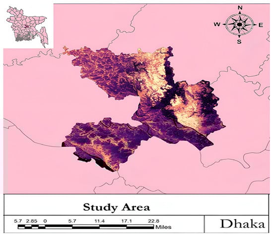
Figure 1.
Study Area of Dhaka District.
Dhaka, the oldest and most centrally positioned city in Bangladesh, is seeing a lot of new businesses and economic activity, which makes it a good place for foreign direct investment. This busy city center creates a lot of economic, social, and cultural opportunities for the whole country [17]. Dhaka, the capital of Bangladesh, experiences a humid subtropical climate, receiving an average annual rainfall ranging between 2000 and 3000 mm. Positioned in central Bangladesh at the lower Ganges Delta, the city has a monsoonal climate with an average temperature of 26 °C (79 °F), varying from 19 °C (66 °F) in January to 29 °C (84 °F) in May. The city receives approximately 87% of its annual rainfall between May and October [18,19,20]. Dhaka’s low-lying topography and inadequate drainage systems exacerbate the issue, leaving many neighborhoods inundated for extended periods. The city’s rapid and uncontrolled expansion has come at the expense of its natural environment, with wetlands and water basins being drained for real estate developments, increasing the risk of flooding. Dhaka’s urban life is deeply interconnected with its rivers, which serve multiple functions, including transportation. However, rapid and unplanned urban expansion over the past two decades has exacerbated waterlogging and urban flooding [17,21,22]. Since Bangladesh’s independence in 1971, Dhaka has transformed from a center for traditional crafts and light manufacturing into the country’s primary industrial hub. Early post-war industrial policy emphasized nationalization, followed by liberalization in the 1980s that opened space for private investment, particularly in textiles and garments [10]. The Tejgaon Industrial Area (4.38 sq. km), one of Dhaka’s oldest industrial hubs, hosts key industries such as BSTI, the Institute of Glass and Ceramics, and Kohinoor Chemical Company Ltd., and is being redeveloped into a mixed-use industrial, commercial, and residential zone. Beyond Tejgaon, the government is expanding industrial capacity through the Dhaka Special Economic Zone in Keraniganj (441 acres) and planned zones in Nawabganj (Dhaka) and Sirajdikhan (Munshiganj), each covering 500 acres. Managed by the Bangladesh Economic Zone Authority, these economic zones are designed to attract domestic and foreign investment, support industries such as chemicals, ceramics, pharmaceuticals, shipbuilding, and light engineering, and facilitate the relocation of nearly 1200 factories from Old Dhaka, thereby promoting decentralized, sustainable, and internationally competitive industrial growth [23,24]. The main goal of this study is to evaluate the suitability of industrial land in the Dhaka District to support sustainable urban and industrial growth. Specifically, the research aims to: 1. Identify areas suitable for industrial development using GIS-based spatial analysis. 2. Include various decision-making criteria, such as environmental factors, accessibility, terrain, and development aspects, through the Analytical Hierarchy Process to assess their influence on industrial suitability. 3. Create a suitability map for urban planners and policymakers to foster sustainable industrial growth. 4. Identify priority areas for future industrial expansion that reduce ecological impact while supporting economic resilience. By accomplishing these goals, this study aims to offer practical insights for sustainable land management and guide long-term industrial development policies in Dhaka.
2. Materials and Methods
2.1. Data Collection
Landsat satellite imagery was used to evaluate the Dhaka District, with Landsat 9 Operational Land Imager (OLI) providing the 2025 dataset. Image preprocessing, including layer stacking and sub-setting with administrative boundary shapefiles, was conducted in ArcMap 10.8 [25]. A Digital Elevation Model (DEM) from the Open Topography platform (NASA datasets) was processed in ArcMap 10.8 to extract topographic information, from which slope gradients were derived to assess terrain characteristics. Land use categories Built-up, Water Body, and Environmental Sensitivity were classified using satellite images downloaded from the United States Geological Survey, USGS Earth Explorer (U.S. Geological Survey, Reston, VA, USA) and processed in ArcMap 10.8. Road networks, river networks, and points of interest were obtained from OpenStreetMap. River and road network densities were analyzed using the Line Density analysis process, while distances from roads, rivers, and points of interest were measured using Euclidean Distance analysis in ArcMap 10.8.
2.2. Data Processing & Analysis
The Analytical Hierarchy Process weighted overlay method was employed, a powerful and widely used technique for Multi-Criteria Decision Making in spatial analysis, which facilitates breaking down a complex problem into a hierarchy of criteria and sub-criteria. Factors like slope and elevation negatively affect industrial development because higher values of these parameters make land less suitable. On the other hand, industrial growth can pose threats to water bodies and sensitive environmental areas. Additionally, being close to major roads is important for industrial suitability, as shorter distances improve access and logistics. In contrast, distances from rivers, developed areas, road network density, river network density, and points of interest significantly increase the suitability of land for industrial development [26,27,28]. Shown in Figure 2.
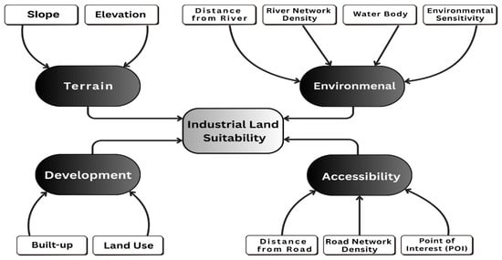
Figure 2.
Methodology of Analysis.
Weights were assigned to four main factors: Environmental (31%), Accessibility (27%), Terrain (25%), and Development (17%). Sub-criteria under Environmental factors included Distance from River and Environmental Sensitivity (29.04% for both), River Network Density (22.58%), and Water Bodies (25.8%). The detailed weights are presented in Table 1, where (+) means a positive and (–) means a negative relationship with industrial land suitability.

Table 1.
Application of Multi-Criteria Decision Making through the Analytical Hierarchy Process for Evaluating Industrial Land Suitability using Weighted Overlay.
Collected data (factors and metrics) were weighted, and land suitability decisions were derived using the Analytical Hierarchy Process method, as illustrated in Figure 3.
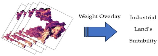
Figure 3.
Weight Overlay Using the Analytical Hierarchy Process Method.
2.2.1. Classification of Land Use Land Cover
Raster images were categorized into five groups for Land Use Land Cover computation: Water Body, Agricultural Land, Vegetation, Urban Area, and Barren Land. The Reclassify tool in ArcMap 10.8 was used to create classified maps. Visual inspection of the Land Use Land Cover distributions over the study years was used to support the thresholds, which were established using the Natural Breaks (Jenks) optimization method.
2.2.2. Industrial Susceptibility
Similarly, ArcMap 10.8, the Natural Breaks (Jenks) optimization method was used to set the classification thresholds. This method enhances differences between classes, at the same time reduces within-class variance. A progression from unsuitable to highly suitable for industrialization was represented by the five ranges into which the suitability was divided: Very Low, Low, Moderate, High, and Very High Suitability.
3. Results & Discussion
3.1. Land Use Land Cover Analysis of Dhaka District
The Land Use Land Cover map of Dhaka District, 2025, Figure 4, shows the intense urbanization concentrated in the metropolitan core and along the Shitalakkhya–Buriganga corridor, continuous conversion of peri-urban agricultural land to built-up use, fragmented vegetation areas in peripheral zones, and signs of riparian encroachment. These spatial patterns indicate rapid, uneven urban growth with significant environmental consequences.
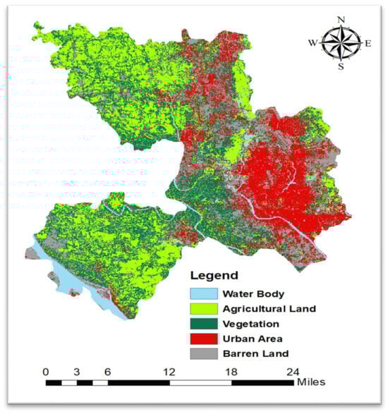
Figure 4.
Land Use Land Cover of Dhaka District, 2025.
3.1.1. Water Body
Water bodies follow recognizable river channels across the map (e.g., Buriganga through the southern central corridor, Turag to the northwest, and Shitalakkhya to the east/southeast near Narayanganj). Some riverine corridors appear narrowed or surrounded by encroachment (built-up or barren zones), indicative of pressure on drainage and floodplains.
3.1.2. Agricultural Land
Agricultural land remains dominant in some upazilas (northwest and southwest pockets). Areas likely to correspond to Dhamrai (northwest of the metropolis), some parts south-west of Keraniganj, and outer fringes show contiguous light-green patches. However, these agricultural pockets are increasingly fragmented as they about expanding urban areas.
3.1.3. Vegetation
Vegetation appears fragmented and patchy. Larger patches occur in peripheral zones and near protected green areas (nearly 9% of the Dhaka District). Inner-city green cover is very limited and isolated: small parks, roadside strips, and remnant vegetation in less developed patches.
3.1.4. Urban Area
The highest urban density is concentrated in the central-east portion of Dhaka District, corresponding to the Dhaka metropolitan core (Motijheel, Gulistan, Paltan, and adjacent neighborhoods), and large contiguous red patches extending east/southeast toward Narayanganj and Demra.
3.1.5. Barren Land
Gray patches concentrated near the urban fringe and along major development corridors indicate active construction, bare soils, and possible industrial yards. These are most visible near peri-urban growth hotspots (Savar, Keraniganj, Gazipur, Narayanganj).
3.2. Industrial Land Suitability
The industrial land suitability analysis of Dhaka District reveals a clear contrast between the urban core and peripheral zones. Central and eastern areas: including Dhaka City, Narayanganj, Keraniganj, and Savar exhibit very low suitability due to urbanization, environmental sensitivity, and dense population. Areas such as Ashulia, Dhamrai, Nawabganj, and southern Tangail fall into low to moderate suitability, constrained by flood risks and competition with agricultural and residential uses. In contrast, high and very high suitability zones are concentrated in the western and northwestern fringes, shown in Figure 5.
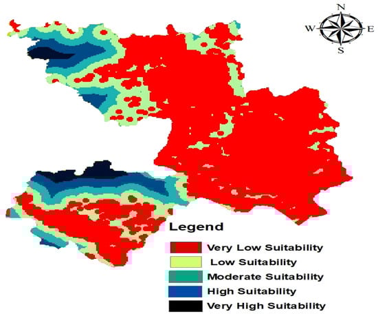
Figure 5.
Industrial Land Suitability of Dhaka District.
Table 2 shows how much land fits into each industrial suitability group. The bulk of the property is classified as Very Low suitability, which means that it is not ideal for industrial development owing to issues such as remoteness from infrastructure, sensitive habitats, or inappropriate topography. Low and Moderate classifications describe land with some promise but significant limits. Only a small percentage of the region is very suitable: High suitability and Very High suitability, implying that the best site for industrial growth is scarce. This emphasizes the importance of careful planning to prevent locating companies in ecologically sensitive or agriculturally valuable regions.
Table 2.
Land Suitability by Percentage of Land.
3.2.1. Very Low Suitability
The majority of Dhaka District, particularly the central and eastern zones, falls within the very low suitability category. This includes the highly urbanized and densely populated core such as Dhaka City, Nawabganj, Dohar, Keraniganj, Demra, Savar, Ashulia, parts of Dhamrai, and the surrounding urban sprawl which are heavily built-up, with scarce land availability, elevated land prices, and significant environmental stresses such as the presence of water bodies, agricultural land, and ecologically sensitive zones rendering them unsuitable for further industrial expansion.
3.2.2. Low Suitability
The transitional belts around the urban core demonstrate low suitability, where peri-urban areas between Ashulia and Gazipur, as well as Savar and Manikganj, parts of Dohar, and Nawabganj are notable examples. While these zones provide some available land and are supported by transport access but constraints such as recurrent flooding, weak infrastructure integration, and competing land demands (residential, commercial, and agricultural) limit their potential for industrial developments.
3.2.3. Moderate Suitability
Peripheral regions, especially the northwestern outskirts near Savar and Gazipur fringes and parts of the southwest parts of Dohar, and Nawabganj towards Manikganj, exhibit moderate suitability. These areas offer comparatively good land availability and benefit from proximity to key transport corridors (Z509, R820, N5). However, environmental challenges such as floodplains and risks of agricultural land conversion reduce their overall viability for large-scale industrial expansion.
3.2.4. High Suitability
The western and northwestern peripheries of Greater Dhaka, particularly towards the Manikganj and Tangail boundaries, fall under the high suitability category. These lands are less flood-prone, relatively open, and spatially removed from the congested city core, water bodies, and environmentally sensitive zones.
3.2.5. Very High Suitability
A few concentrated pockets in the far western and southwestern edges (along the Manikganj–Rajbari belt and some of the eastern part attached to Manikganj, north-eastern part from Savar-Dhamrai, not more than 10–15% of the district) of the study area are classified as very highly suitable. These zones are less congested and characterized by more stable terrain, improved drainage, and scope for planned industrial clusters. Their strategic positioning along expanding road networks and national highways (N5, R820, Z8204) enhances connectivity and will be attractive for the best location to increase sustainable industrial development.
3.3. Discussion
Previous studies on industrial land suitability and urban sustainability have largely emphasized isolated aspects such as land-conversion dynamics, ecological policy linkages, or regional-scale zoning, rather than fully integrated, district-level approaches. Early work in Savar of Dhaka applied Multi-Criteria Evaluation to assess urban expansion and identified flood risk, poor drainage, and limited accessibility as key constraints, with only a small portion of land considered suitable for development [29]. Similarly, in other found that rapid fringe expansion and loss of agricultural land threatened Dhaka’s spatial balance, underscoring the need for consolidated and sustainable land management [30]. However, both studies lacked high-resolution data and environmental weighting, leaving the spatial-ecological trade-offs in industrial zoning underexplored. Comparable global studies using GIS-Analytical Hierarchy Process and multi-criteria models [4,6,7,8,9,10] also reported that environmental sensitivity, terrain, and infrastructure were dominant factors determining suitability. For instance, findings from North Africa and the Middle East indicated that only 10–20% of the land typically met optimal suitability thresholds, which aligns closely with this study’s 10–15% result. By integrating elevation data and assigning 31% weight to environmental criteria, this study not only corroborates those patterns but also identifies western and northwestern corridors as strategic industrial zones. Critically, these areas coincide with prime agricultural land, revealing a spatial trade-off between industrial expansion and food security-a quantified dimension not captured in earlier regional or global works.
3.4. Land Use Tradeoffs
Although the suitability analysis identifies optimal areas for industrial development, there are significant trade-offs that must be considered. The areas marked as ‘High’ and ‘Very High’ suitability are mainly in the western and northwestern edges. Land Use Land Cover analysis shows that this land is mostly categorized as ‘Agricultural Land’ and ‘Vegetation.’ This means that any future industrial development, even in the best locations, will take place at the cost of existing farmland and natural habitats. We can trade-off this situation by planned Industrial Development or making effective plantation program to balance the loss. The areas that are most suitable for industrialization, should be announced as economic zone by the government for further development. Overall road network and infrastructure should be developed and the connectivity with central urban areas should be increased. If the industrial zone is located in the environmentally sensitive area, then as trade-off for industrial expansion Net Zero Industry concept should be implemented. Future research should broaden the Analytical Hierarchy Process model to include biodiversity, agriculture, and essential vegetation. This will allow for a better analysis of the trade-offs related to sustainable industrial development [31,32,33]. To effectively account for these trade-offs, the GIS approach should include distinct layers for agricultural and environmental appropriateness, in addition to the Industrial model. High-value agriculture and environmentally sensitive regions can be designated as exclusion zones, while the remaining areas can be examined using a multi-criterion overlay to determine where industrial expansion will cause the least conflict. This strategy aids in distinguishing zones where development is suitable from zones where preservation is critical, resulting in more balanced and sustainable land-use planning.
4. Conclusions
The Dhaka District is currently experiencing a lot of trouble because of uncontrolled industrial growth, fast urbanization, and deteriorating environmental conditions. This study aimed to tackle the significant challenge of focusing on appropriate sites for industrial development that harmonize economic growth with sustainability. The study methodically assessed environmental, accessibility, terrain, and developmental factors through the integration of GIS, remote sensing data, and the Analytical Hierarchy Process. The Land Use Land Cover analysis showed that the metropolitan core is becoming more urbanized, vegetation is becoming more fragmented, riparian zones are being encroached upon, and a lot of the outskirts agricultural land is being changed into other uses. Suitability modelling showed that most of the central and eastern parts of Dhaka are not suitable for further industrialization. However, the western and northwestern edges of the district are better places for sustainable development. Additionally, significant infrastructure is under development, including the BSCIC Tannery Industrial Estate and the Dhaka Tannery Industrial Estate Waste Treatment Plant Company Limited in these areas. The findings have a significant impact on urban planning and policy. Industrial Land Suitability Analysis emphasizes how urgent it is to safeguard environmentally delicate areas (nearly 9%), conserve agricultural land, and promote industrial development toward more appropriate locations. With the help of ecological protections and transportation connectivity, the strategic distribution of industrial zones can lessen land-use conflicts and enhance sustainability over the long run. This study adds to Dhaka’s planning agenda by offering a replicable GIS–Multi Criteria Decision Making framework, which also serves as a model for other rapidly urbanizing South Asian cities facing identical obstacles.
Author Contributions
Conceptualization, S.T.J.S.; methodology, S.T.J.S.; software, S.T.J.S.; validation, S.T.J.S.; E.I.A. and D.R.H.K.; formal analysis, S.T.J.S.; writing—original draft preparation, E.I.A. and S.T.J.S.; writing—review and editing, E.I.A., S.T.J.S. and D.R.H.K.; visualization, S.T.J.S. and D.R.H.K. supervision, S.T.J.S.; All authors have read and agreed to the published version of the manuscript.
Funding
This research received no external funding.
Institutional Review Board Statement
Not applicable.
Informed Consent Statement
Not applicable.
Data Availability Statement
The original data presented in this study are openly available in USGS Earth Explorer at https://earthexplorer.usgs.gov (accessed 10 June 2025), in OpenTopography at https://opentopography.org (accessed 10 June 2025), and in OpenStreetMap at https://www.openstreetmap.org (accessed on 11 June 2025).
Conflicts of Interest
Authors declare no conflict of interest.
References
- Rahman, M.S.; Chowdhury, S.; Kabir, M.H. Land Cover Change Prediction of Dhaka City: A Markov Cellular Automata Approach. Available online: https://geospatialworld.net/article/land-cover-change-prediction-of-dhaka-city-a-markov-cellular-automata-approach/ (accessed on 10 June 2025).
- Sunny, F.A.; Karimanzira, T.; Huang, Z. Environment Security: An Empirical Study of Industrialization and the Impact on Environment in the Dhaka Division, Bangladesh. Environ. Dev. Sustain. 2012, 14, 885–900. [Google Scholar] [CrossRef]
- Alam, M.S.; Han, B.; Al-Mizan; Pichtel, J. Assessment of Soil and Groundwater Contamination at a Former Tannery District in Dhaka, Bangladesh. Environ. Geochem. Health 2020, 42, 1905–1920. [Google Scholar] [CrossRef]
- Ullah, K.M.; Mansourian, A. Evaluation of Land Suitability for Urban Land-Use Planning: Case Study D Haka City. Trans. GIS 2016, 20, 20–37. [Google Scholar] [CrossRef]
- Hanif, M.A.; Ahasanuzzaman, A.S.M. A Study on Development Trend of Tejgaon Industrial Area. In Proceedings of the International Conference on Water Resources and Environmental Management (ICWREM), Dhaka, Bangladesh, 28–30 October 2017. [Google Scholar]
- Al-Ghorayeb, A.; Al-Shaar, W.; Elkordi, A.; Faour, G.; Al-Shaar, M.; Attalah, Y. Land Suitability Analysis for Sustainable Urban Development: A Case of Nabatiyeh Region in Lebanon. J 2023, 6, 267–285. [Google Scholar] [CrossRef]
- Salunkhe, S.; Nandgude, S.; Tiwari, M.; Bhange, H.; Chavan, S.B. Land Suitability Planning for Sustainable Mango Production in Vulnerable Region Using Geospatial Multi-Criteria Decision Model. Sustainability 2023, 15, 2619. [Google Scholar] [CrossRef]
- Mansourihanis, O.; Maghsoodi Tilaki, M.J.; Yousefian, S.; Zaroujtaghi, A. A Computational Geospatial Approach to Assessing Land-Use Compatibility in Urban Planning. Land 2023, 12, 2083. [Google Scholar] [CrossRef]
- Nath, A.; Koley, B.; Choudhury, T.; Saraswati, S.; Ray, B.C.; Um, J.-S.; Sharma, A. Assessing Coastal Land-Use and Land-Cover Change Dynamics Using Geospatial Techniques. Sustainability 2023, 15, 7398. [Google Scholar] [CrossRef]
- Okacha, A.; Salhi, A.; Abdelrahman, K.; Fattasse, H.; Lahrichi, K.; Bakhouya, K.; Mondal, B.K. Balancing Environmental and Human Needs: Geographic Information System-Based Analytical Hierarchy Process Land Suitability Planning for Emerging Urban Areas in Bni Bouayach Amid Urban Transformation. Sustainability 2024, 16, 6497. [Google Scholar] [CrossRef]
- Zhang, L.; Lin, X.; Qiu, B.; Zhang, M.; He, Q. The Industrial Sprawl in China from 2010 to 2019: A Multi-Level Spatial Analysis Based on Urban Scaling Law. IJERPH 2022, 19, 16255. [Google Scholar] [CrossRef] [PubMed]
- Sharma, J.; Arora, M.; Sonia; Alsharef, A. An Illustrative Study on Multi Criteria Decision Making Approach: Analytical Hierarchy Process. In Proceedings of the 2022 IEEE 2nd International Conference on Advance Computing and Innovative Technologies in Engineering (ICACITE), Greater Noida, India, 28–29 April 2022; pp. 2000–2005. [Google Scholar]
- De Felice, F.; Petrillo, A. (Eds.) The Art of Decision Making: Applying AHP in Practice; Business, Management and Economics; IntechOpen: London, UK, 2025; ISBN 978-1-83769-768-7. [Google Scholar]
- Rahman, M.; Szabó, G. Impact of Land Use and Land Cover Changes on Urban Ecosystem Service Value in Dhaka, Bangladesh. Land 2021, 10, 793. [Google Scholar] [CrossRef]
- Roy, S.K.; Alam, M.T.; Mojumder, P.; Mondal, I.; Kafy, A.-A.; Dutta, M.; Ferdous, M.N.; Al Mamun, M.A.; Mahtab, S.B. Dynamic Assessment and Prediction of Land Use Alterations Influence on Ecosystem Service Value: A Pathway to Environmental Sustainability. Environ. Sustain. Indic. 2024, 21, 100319. [Google Scholar] [CrossRef]
- Basak, P.; Momtaz, S.; Gaston, T.F.; Dey, S. Changing Land Use and Urban Dynamics around an Industrial Zone in Bangladesh: A Remote Sensing Analysis. Land 2023, 12, 1753. [Google Scholar] [CrossRef]
- Hosen, M.M.; Hamed, M.M.; Muhammad, M.K.I.; Shahid, S. Satellite Nighttime Light and Digital Elevation Data to Assess Urban Expansion in Floodplains of Dhaka City. Knowl.-Based Eng. Sci. 2023, 4, 51–64. [Google Scholar] [CrossRef]
- Ahmed Shourav, M.S.; Mohsenipour, M.; Alamgir, M.; Hadi Pour, S.; Ismail, T. Historical trends and future projection of climate at Dhaka city of Bangladesh. J. Teknol. 2016, 78. [Google Scholar] [CrossRef]
- Shourav, M.S.A.; Shahid, S.; Singh, B.; Mohsenipour, M.; Chung, E.-S.; Wang, X.-J. Potential Impact of Climate Change on Residential Energy Consumption in Dhaka City. Environ. Model. Assess. 2018, 23, 131–140. [Google Scholar] [CrossRef]
- Alam, M.; Rabbani, M.D.G. Vulnerabilities and Responses to Climate Change for Dhaka. Environ. Urban. 2007, 19, 81–97. [Google Scholar] [CrossRef]
- Alam, R.; Quayyum, Z.; Moulds, S.; Radia, M.A.; Sara, H.H.; Hasan, M.T.; Butler, A. Dhaka City Water Logging Hazards: Area Identification and Vulnerability Assessment through GIS-Remote Sensing Techniques. Environ. Monit. Assess. 2023, 195, 543. [Google Scholar] [CrossRef] [PubMed]
- Sayed, M.B.; Haruyama, S. Evaluation of Flooding Risk in Greater Dhaka District Using Satellite Data and Geomorphological Land Classification Map. J. Geosci. Environ. Prot. 2016, 4, 110–127. [Google Scholar] [CrossRef]
- Siddiqui, K.; Ahmed, J.; Siddique, K.; Huq, S.; Hossain, A.; Nazimud-Doula, S.; Rezawana, N. Social Formation in Dhaka, 1985–2005: A Longitudinal Study of Society in a Third World Megacity, 1st ed.; Routledge: London, UK, 2016; ISBN 978-1-315-60944-7. [Google Scholar]
- Milad, M. Wave of Industrialisation Begins in 1990s. Prothom Alo. Updated 23 December 2021. Available online: https://en.prothomalo.com/business/local/wave-of-industrialisation-begins-in-1990s (accessed on 10 June 2025).
- NASA JPL. NASADEM Merged DEM Global 1 arc Second V001. Distributed by OpenTopography. 2021. Available online: https://doi.org/10.5069/G93T9FD9 (accessed on 10 June 2025).
- Romeijn, H.; Faggian, R.; Diogo, V.; Sposito, V. Evaluation of Deterministic and Complex Analytical Hierarchy Process Methods for Agricultural Land Suitability Analysis in a Changing Climate. IJGI 2016, 5, 99. [Google Scholar] [CrossRef]
- Maddahi, Z.; Jalalian, A.; Kheirkhah Zarkesh, M.M.; Honarjo, N. Land Suitability Analysis for Rice Cultivation Using a GIS-Based Fuzzy Multi-Criteria Decision Making Approach: Central Part of Amol District, Iran. Soil Water Res. 2017, 12, 29–38. [Google Scholar] [CrossRef]
- Pramanik, M.K. Site Suitability Analysis for Agricultural Land Use of Darjeeling District Using AHP and GIS Techniques. Model. Earth Syst. Environ. 2016, 2, 56. [Google Scholar] [CrossRef]
- Fatema, R. Analysis of Land Suitability for Urban Development in the Eastern Fringe of Dhaka City: An Application of Multicriteria Evaluation Technique. Available online: http://lib.buet.ac.bd:8080/xmlui/handle/123456789/1659?show=full (accessed on 10 June 2025).
- Islam, I.; Sharmin, M.; Masud, F.; Moniruzzaman, M. Urban Consolidation Approach for Dhaka City: Prospects and Constraints. Available online: https://www.bip.org.bd/admin/uploads/member-publication/2009/TybP4Jpa20130804105550.pdf (accessed on 10 June 2025).
- Ma, W.; Yang, H.; Jiang, G.; Zhou, T.; Zhao, Q. Exploring Trade-Offs between Residential and Industrial Functions in Rural Areas and Their Ecological Impacts across Transitioning Agricultural Systems: Evidence from the Metropolitan Suburbs of China. J. Environ. Manag. 2024, 358, 120907. [Google Scholar] [CrossRef] [PubMed]
- Zhao, Y.; Wang, M.; Lan, T.; Xu, Z.; Wu, J.; Liu, Q.; Peng, J. Distinguishing the Effects of Land Use Policies on Ecosystem Services and Their Trade-Offs Based on Multi-Scenario Simulations. Appl. Geogr. 2023, 151, 102864. [Google Scholar] [CrossRef]
- Fan, Y.; Gan, L.; Hong, C.; Jessup, L.H.; Jin, X.; Pijanowski, B.C.; Sun, Y.; Lv, L. Spatial Identification and Determinants of Trade-Offs among Multiple Land Use Functions in Jiangsu Province, China. Sci. Total Environ. 2021, 772, 145022. [Google Scholar] [CrossRef]
Disclaimer/Publisher’s Note: The statements, opinions and data contained in all publications are solely those of the individual author(s) and contributor(s) and not of MDPI and/or the editor(s). MDPI and/or the editor(s) disclaim responsibility for any injury to people or property resulting from any ideas, methods, instructions or products referred to in the content. |
© 2025 by the authors. Licensee MDPI, Basel, Switzerland. This article is an open access article distributed under the terms and conditions of the Creative Commons Attribution (CC BY) license (https://creativecommons.org/licenses/by/4.0/).