Abstract
This case report presents a multidisciplinary forensic investigation into a cold case involving a missing person in Italy, likely linked to a homicide that occurred in 2008. The investigation applied a standardized protocol integrating satellite imagery analysis, site reconnaissance, vegetation clearance, ground-penetrating radar (GPR), and cadaver dog (K9) deployment. A dedicated decision tree guided each phase, allowing for efficient allocation of resources and minimizing investigative delays. Although no human remains were recovered, the case demonstrates the practical utility and operational robustness of a structured, evidence-based model that supports decision-making even in the absence of positive findings. The approach highlights the relevance of “negative” results, which, when derived through scientifically validated procedures, offer substantial value by excluding burial scenarios with a high degree of reliability. This case is particularly significant in the Italian forensic context, where the adoption of standardized search protocols remains limited, especially in complex outdoor environments. The integration of geophysical, remote sensing, and canine methodologies—rooted in forensic geoarchaeology—provides a replicable framework that enhances both investigative effectiveness and the evidentiary admissibility of findings in court. The protocol illustrated in this study supports the consistent evaluation of large and morphologically complex areas, reduces the risk of interpretive error, and reinforces the transparency and scientific rigor expected in judicial settings. As such, it offers a model for improving forensic search strategies in both national and international contexts, particularly in long-standing or high-profile missing persons cases.
1. Introduction
Forensic investigations play a critical role in the justice system by providing scientifically validated evidence essential for fair and accurate judicial outcomes [1,2,3,4]. However, without standardized protocols, the reliability and interpretive accuracy of forensic findings can vary significantly, leading to inconsistencies that impact judicial processes [5,6,7,8]. A systematic approach, including well-defined Standard Operating Procedures (SOP), is crucial, especially in complex Crime Scene Investigations where physical evidence may be sparse or ambiguous [9,10,11,12,13]. Despite the adoption of existing procedures in specific forensic disciplines, there is a lack of clear guidance when a multidisciplinary approach needs to be applied in complex scenarios. This study highlights the importance of integrating techniques from various fields within a strategic framework to strengthen the chain of evidence and enhance interpretative reliability.
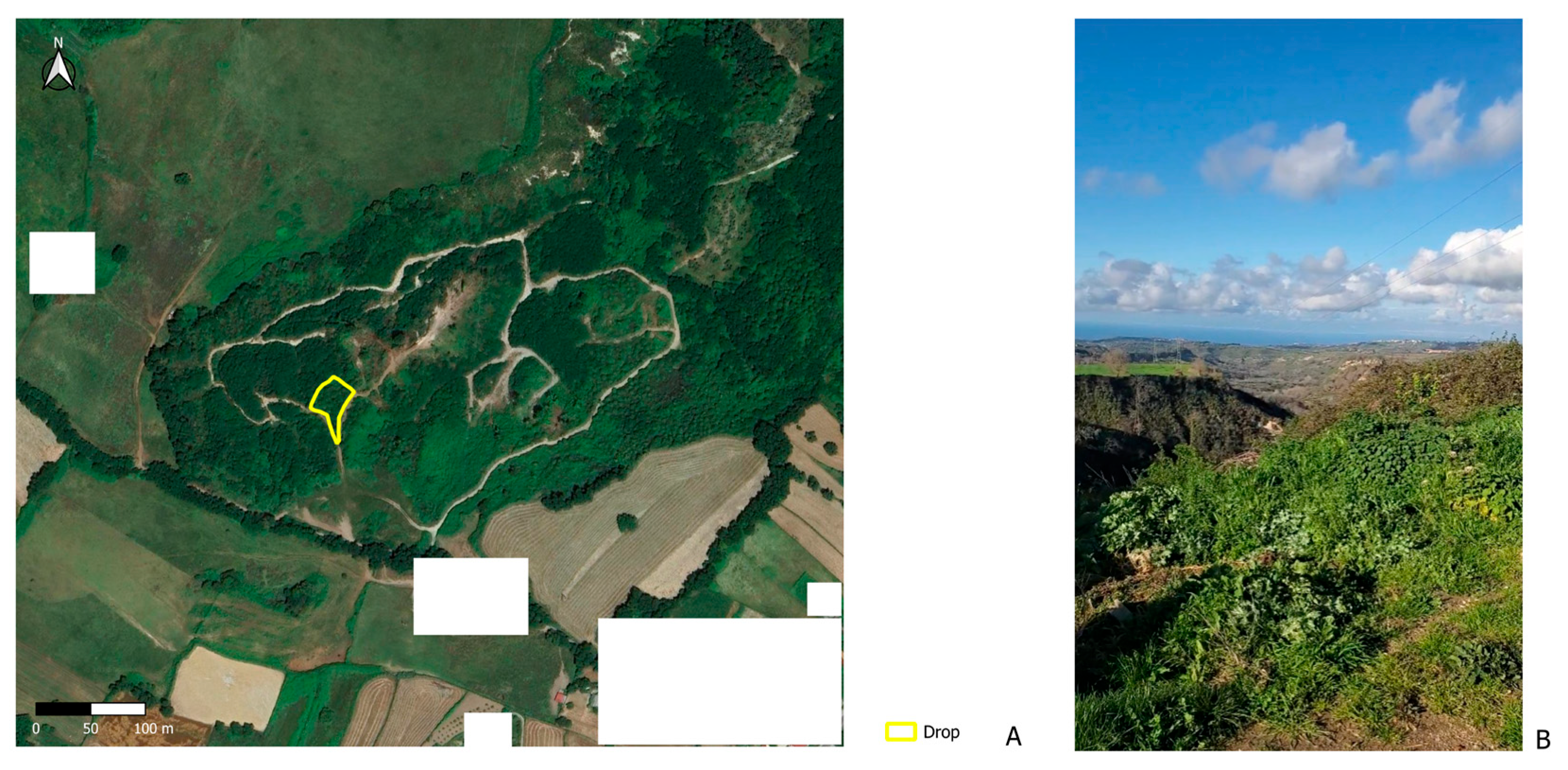
The case report presented here concerns a cold case of a missing person, suspected to be a homicide victim, who was last seen in June 2008 in Italy. In 2024, the investigation was reopened based on new information provided by a justice collaborator—a witness with knowledge of the suspects—who identified potential burial sites within a rural and forested area (approximately 4 hectares), predominantly composed of badlands, a Calanchi formation, characterized by high erosion, unstable stratigraphy, and complex topography [14]. Normally, such a task would require time-consuming and highly costly operations due to the size and complexity of the area of interest. Thus, given the challenging terrain and the long time since the suspected homicide, the investigation required a phased and highly structured approach (Figure 1).
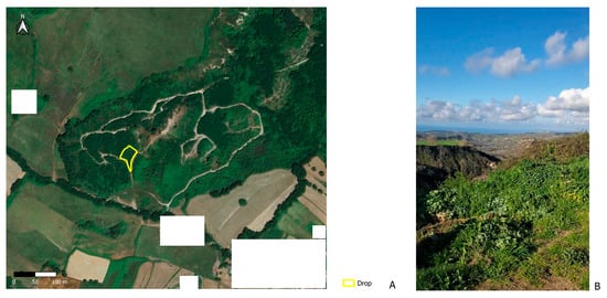
Figure 1.
The rural, forested badland area under investigation, shown in an aerial view (A) and from the ground (B). In Figure 1A, the area surveyed during Phase 2 of the investigation—referred to as the “drop” due to its geometric shape—is highlighted in yellow. White rectangles have been added to anonymize the location by obscuring residential buildings and ensuring the area is not identifiable.
The objective of this case report is to evaluate the efficacy of a standardized, multidisciplinary forensic protocol. This protocol aims to integrate advanced methods in forensic geoarchaeology, such as Remote Sensing, and Ground Penetrating Radar (GPR), along with forensic K9 units (specialized canine teams trained to detect the scent of human decomposition, even in advanced or skeletonized states) and traditional investigative practices [15]. By integrating these tools, investigators were able to non-invasively explore subsurface areas, efficiently collect data, and minimize the use of destructive methods [16,17,18,19,20,21,22,23,24,25,26,27,28,29]. Additionally, the application of the principles of Bayesian probability within the investigative framework enables a quantitative evaluation of evidence, allowing investigators to assess the probability of findings based on prior information [30,31,32]. This case report aims to demonstrate that a standardized, interoperability-based protocol ensures consistent and scientifically robust results, even in cases with “negative” findings, which are nonetheless crucial for guiding investigative decisions and enhancing judicial clarity.
While this study presents a single-case investigation that did not result in the recovery of human remains, the structured approach it illustrates is intended as a transferable model rather than a universally prescriptive protocol. The absence of positive findings highlights a key objective of the protocol: the ability to conclusively exclude areas through non-invasive, data-driven analysis. The methodology’s adaptability to different forensic scenarios—including varied soil conditions, post-mortem intervals, and levels of witness reliability—is discussed further in the Section 4.
What distinguishes the proposed approach is not the novelty of individual tools—such as GPR, K9, or satellite imaging—but their integration within a structured, interoperable decision-making protocol. This includes the explicit use of a weighted a priori table informed by Bayesian principles, which, to our knowledge, has not been systematically applied in real-world forensic recovery operations over large and environmentally complex areas. The innovative aspect lies in formalizing a workflow that balances investigative efficiency, evidentiary robustness, and adaptability to site-specific constraints.
2. Materials and Methods
2.1. Phase 1: Preliminary Investigations and Decision Flowchart
A comprehensive investigation utilizing satellite imagery analysis, site reconnaissance, vegetation clearance, GPR surveys (a Noggin System equipped with a 500 MHz antenna), and K9 unit deployment was conducted to identify potential burial sites as indicated by a witness. The analysis began with two satellite images taken before (17 May 2008) and after (20 July 2008) the disappearance, allowing investigators to scrutinize landscape changes that might suggest ground disturbance or areas where burial could have occurred. The comparison between 2008 imagery and both subsequent and current conditions was further supported by field verification and photo interpretation in collaboration with witnesses. Several areas underwent substantial transformation due to forestry operations and partial land remediation, which were confirmed through both satellite analysis and direct visual assessments. These landscape modifications through the years complicated the initial recognition of the site, making visual comparisons alone insufficient without contextual multispectral support.
This pre- and post-event multispectral comparison was critical in detecting any notable anomalies in the terrain that might correlate with the suspected burial sites. Satellite imagery served not only as a preliminary screening tool but also supported the geoarchaeological evaluation of land use patterns and stratigraphic context, consistent with current best practices in forensic archaeology [15,27,29]. When combined with field reconnaissance and intelligence data, this integration helps narrow the search area prior to deploying more intrusive techniques. In our investigation, landscape changes observed in the imagery were cross-referenced with soil and topographic conditions to prioritize candidate sites for GPR and, when needed, K9 confirmation. Environmental variables such as vegetation density, terrain compactness, and weather conditions (e.g., recent precipitation affecting scent diffusion or radar penetration) were continuously considered when determining tool sequence and data reliability. The final decision to excavate was reserved for sites with converging positive indications, ensuring efficient resource use and minimizing false positives.
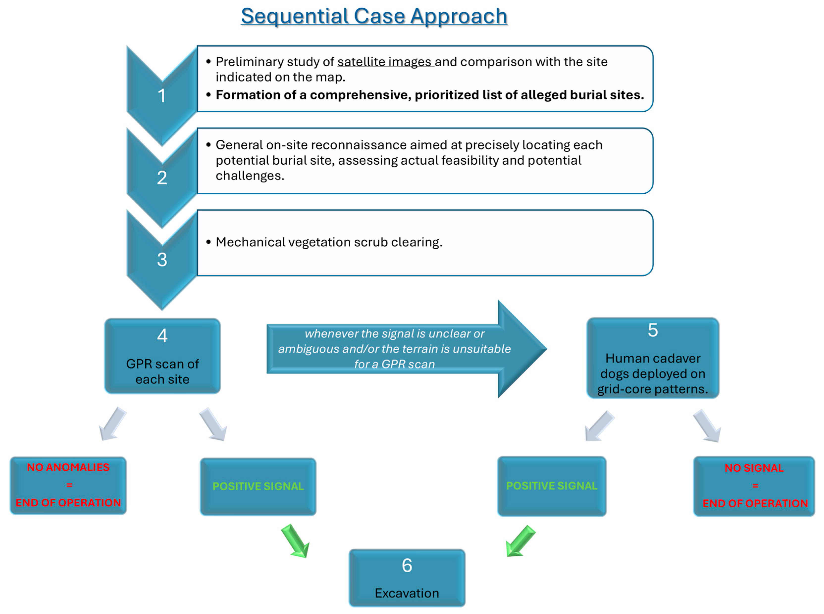
Given the size and complexity of the area of interest, a flowchart was developed and implemented to streamline the entire research operation, specifically to minimize downtime and reduce personnel and labor inefficiencies (Figure 2).

Figure 2.
Sequential decision tree guiding the investigation, from satellite image analysis and witness-based site prioritization to field reconnaissance, vegetation clearance, GPR scanning, and K9 deployment. Weather, soil conditions, and terrain complexity were considered at each phase. Excavation was performed only where positive, converging signals emerged. The flowchart ensured efficient use of resources in a challenging and modified landscape.
Site reconnaissance followed the imagery analysis, focusing on the practicality and accessibility of these potential burial sites. Investigators examined access points, soil composition, vegetation density, and general visibility across five candidate locations. Key considerations included soil compactness and the type of vegetation, both of which were expected to influence the accuracy of GPR scans and the effectiveness of K9 scent detection. By assessing these environmental factors, investigators could determine the sites most likely to yield reliable results in subsequent stages of the investigation.
To facilitate a thorough examination, mechanical vegetation clearance was performed across designated areas. Clearing the vegetation allowed for unimpeded access to the sites, which was essential for both the GPR and K9 operations. This preparation minimized potential sources of interference that could otherwise generate false-positive signals during subsurface scanning and scent detection activities. Importantly, mechanical clearing did not interfere with K9 operations. On the contrary, it was carried out in coordination with the dog handlers to improve the diffusion of scent markers from the soil, particularly in compact or forested terrains.
Once the sites were prepared, GPR surveys were conducted in both single lines and systematic grid patterns across each suspected burial site to locate subsurface anomalies for a total distance of about 10 km. The GPR scans focused on detecting changes in soil layers that might indicate prior digging, refilling, or any voids beneath the surface. However, certain limitations, such as uneven terrain, impacted the resolution of the GPR data, necessitating cautious interpretation and a careful review of the findings to avoid misidentifying natural geological features as potential burial markers.
Following the identification of GPR anomalies, cadaver dogs were deployed to search for human remains. The dogs, trained to detect decomposition markers even in advanced stages of decay, worked in core grid patterns to ensure comprehensive coverage of each site. Although no soft tissue decomposition products were expected due to the elapsed time, the decision to deploy cadaver dogs was based on their demonstrated ability to detect volatile compounds associated with human decomposition, including in skeletonized remains. Several studies have shown that trained forensic dogs can still detect burial sites even after many years, depending on environmental factors and soil conditions [15,28]. The K9 units provided an additional layer of validation, with their scent-detection abilities offering a sensitive, on-the-ground approach to identifying potential burial areas. However, environmental variables, including soil type, moisture levels, and the time elapsed since the suspected burial, could influence detection accuracy. Well combined, these methodologies provided a multi-layered search tool aimed at locating potential burial sites with precision and thoroughness.
As investigators assessed the scene during each phase of the chart, it was possible to plan subsequent steps with efficient timing. On the scrub-cleared sites, GPR proved pivotal in guiding the next steps. While this paper is not intended as a comparative study, the use of K9 scent-based research in this case followed a structured operational protocol adopted by the Carabinieri’s official cadaver dog units. Specifically, it is standard procedure—especially in forested or compacted environments—for handlers to request the creation of a regular grid of boreholes to facilitate the release of volatile organic compounds from potential burial sites, enhancing the olfactory performance of the dogs. This technique is regularly used by the Italian Carabinieri K9 teams, and its application in this context was not specific to the site but a reflection of current best practices [33,34]. While effective, the process introduces additional time and logistical requirements, particularly when the terrain is extremely hard and mechanized drilling is necessary. For this reason, K9 deployment was prioritized only after preliminary GPR results, balancing investigative thoroughness with operational efficiency. GPR was selected as a first-pass screening tool due to its ability to rapidly scan large areas, and canine teams were subsequently deployed in a targeted manner, based on data-driven site selection.
Although K9 units and GPR detect different markers—chemical traces of decomposition versus physical ground disturbance—their integration in a sequenced strategy was determined by operational constraints and methodological complementarity. Specifically, GPR was prioritized as the initial subsurface screening tool due to its efficiency in identifying voids or anomalies over large areas. Only in cases where GPR returned ambiguous results, or when no anomalies were detected despite other suggestive indicators (e.g., witness input, satellite imagery), were K9 units deployed. This choice also reflects logistical factors such as site hardness, which required pre-drilled grids to support canine detection in deeply compacted soils. While simultaneous use is ideal in theory, a phased deployment allowed us to optimize resources while reducing redundancy. (Figure 2).
To evaluate the reliability of the approach, the authors intentionally excavated sites where neither K9 nor GPR signals were detected at a depth of 2 m below the soil surface. In these cases, only soil layers were observed (no foreign objects, rocks, or voids), providing validation in terms of false negative results.
2.2. Phase 1: Excavation and Evidence Analysis
Excavation efforts focused exclusively on areas where both ground-penetrating radar (GPR) and K9 units indicated potential anomalies, ensuring targeted investigation. Each excavation adhered to strict archeological protocols to preserve the integrity of any potential evidence. When excavations revealed that anomalies were natural formations, such as animal burrows or root clusters, these findings were carefully documented to maintain a complete and accurate record of the investigation process.
To systematically assess the likelihood of a burial site, investigators utilized an “a priori evidence table” prediction scheme (see Figure 6 later in the text). This scheme was designed to integrate data from multiple sources, including satellite imagery, GPR results, K9 indications, and witness statements. This table assigned probabilistic values to each data source, calculating an overall likelihood score for each site. Positive findings from any source increased a site’s score, while negative or ambiguous indications decreased the probability of further investigation being warranted. This Bayesian approach allowed investigators to make data-driven decisions on whether to continue or conclude excavations at particular locations, ensuring that resources were allocated effectively based on an integrated evaluation of all available evidence. To support practical understanding and replicability, an anonymized example of how probabilistic values and weights were assigned to each source (satellite imagery, GPR, K9 detection, and witness testimony) is provided in Appendix A. Each source was given a weight based on its reliability and contextual relevance (e.g., GPR and K9 at 30% each; satellite imagery and witness accounts at 20% each), and the cumulative likelihood was then calculated to classify sites into operational categories (Excavated, Reserved, or Excluded). This example is intended to demonstrate the quantitative logic behind the a priori table and provide transparency for its future adaptation.
2.3. Phase 2: Follow-Up Investigations
After Phase 1, the witness revisited the site and provided further insights based on the current landscape conditions, which had changed since 2008. Although described as a separate phase, this follow-up investigation was conducted within the same operational scenario and followed the standardized protocol illustrated in Figure 2. Each step—reconnaissance, geophysical survey, and K9 assessment—was re-applied systematically to the newly indicated area. The witness identified a specific area, referred to as “the drop,” due to its distinctive shape on the map, which aligned with his recollection of the original scene (see Figure 1). In response, investigators conducted additional GPR and K9 unit assessments within this newly designated area to explore the possibility of a burial site.
Secondary excavations were subsequently conducted in “the drop” area, with investigators employing refined search techniques guided by updated witness information. Despite these targeted efforts, no evidence of human remains was discovered during the additional excavations. This finding reinforced the conclusion of the CSI squad that it was highly probable no burial had occurred at this location and that no corpses remained within the area. Ultimately, this outcome led to the closure of the operation, as the absence of findings justified the decision to cease further searches at the site.
3. Results
3.1. Findings from Phase 1
The investigation began with an analysis of satellite imagery to detect any signs of ground disturbance that could indicate a burial site. While the images revealed minimal surface changes and provided no conclusive evidence of burial, they reinforced the need for on-site confirmation. Satellite data alone was insufficient to rule out potential sites, but it served as an initial filter, helping to narrow down the areas that warranted further investigation on the ground (Figure 3).
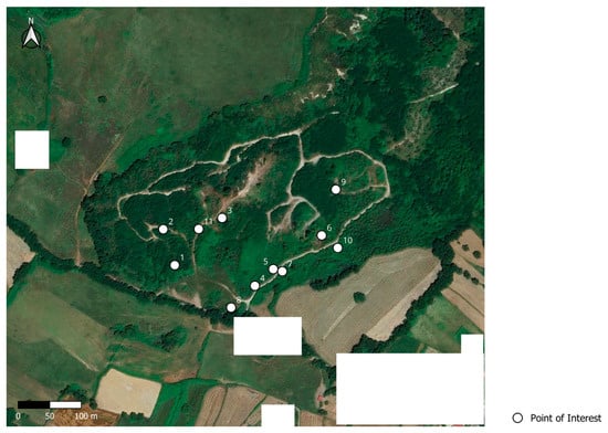
Figure 3.
Eleven anomalies detected by the satellite analysis during phase 1. Note that white rectangles have been added to anonymize the location by obscuring residential buildings and ensuring the area is not recognizable.
During the on-site reconnaissance, investigators evaluated five locations identified through witness testimony and satellite analysis. Preliminary assessments revealed that three of these sites possessed characteristics suitable for a potential burial, including physical accessibility, soil composition, and conditions conducive to hand digging. In contrast, two locations were deemed unsuitable due to environmental factors, such as rocky soil or dense vegetation, which would have made burial in these areas highly improbable.
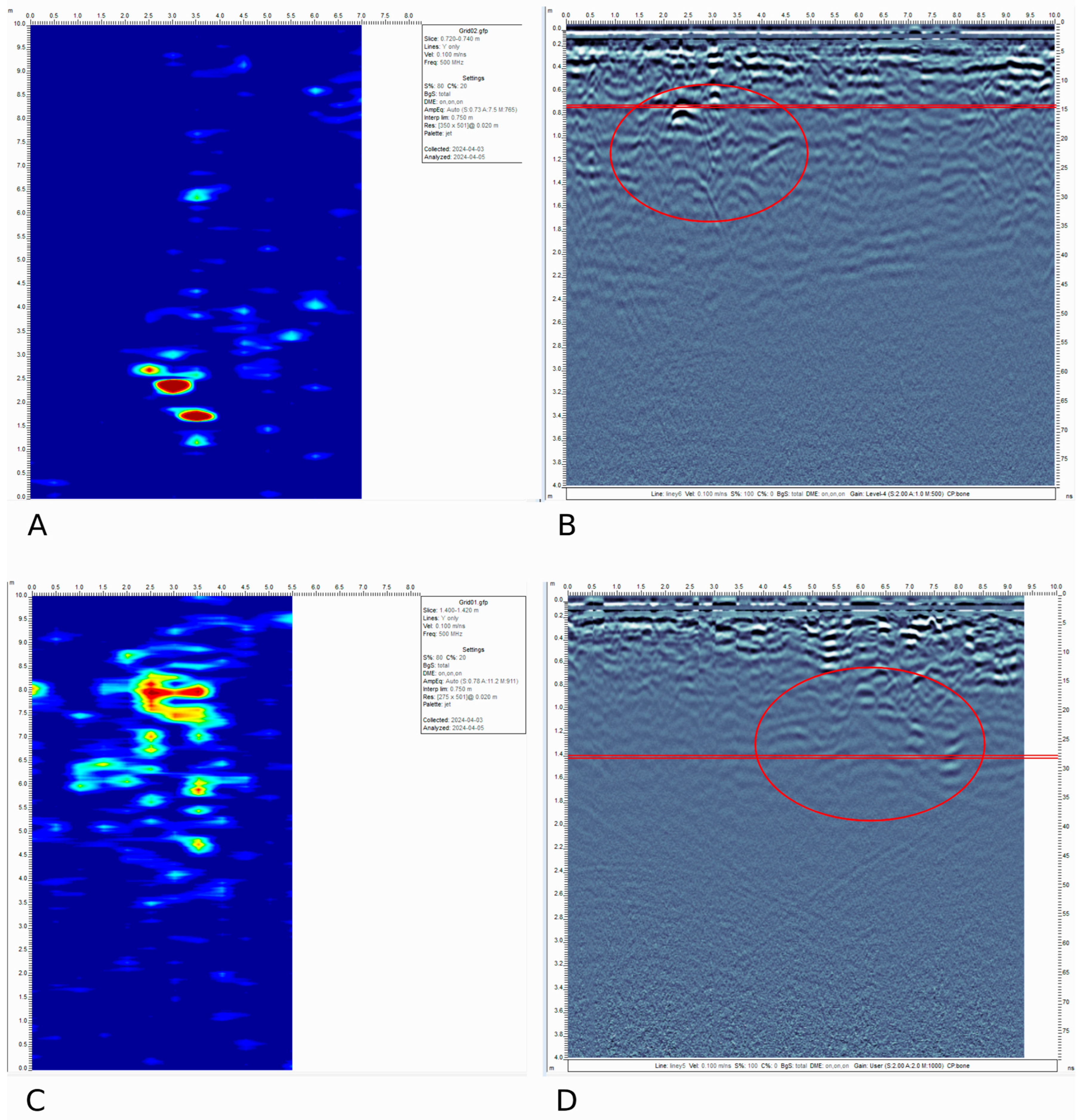
GPR was then deployed at the nine feasible remaining sites to detect subsurface anomalies. GPR scans revealed unusual patterns at only two locations, initially suggesting possible human intervention. The GPR data did not require extensive processing due to their generally good quality and electromagnetic signal penetration (approximately 2 m). Only Dewow, Migration, and standard Envelope (DME) were applied using a velocity of 0.10 m/ns (Figure 4). However, when these anomalies were excavated, they were identified as natural geological formations or as the result of animal activities, rather than evidence of a burial (Figure 5).

Figure 4.
The image shows both the radargram (B,D) and the corresponding depth-slice (A,C) of the only two anomalies detected by the GPR in the satellite areas of interest. (A,B) as well as (C,D), display a clear anomaly (circled in red in the radargrams and with high Average Envelope Amplitude—AEA—values in the depth-slices).
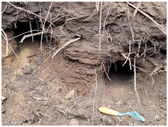
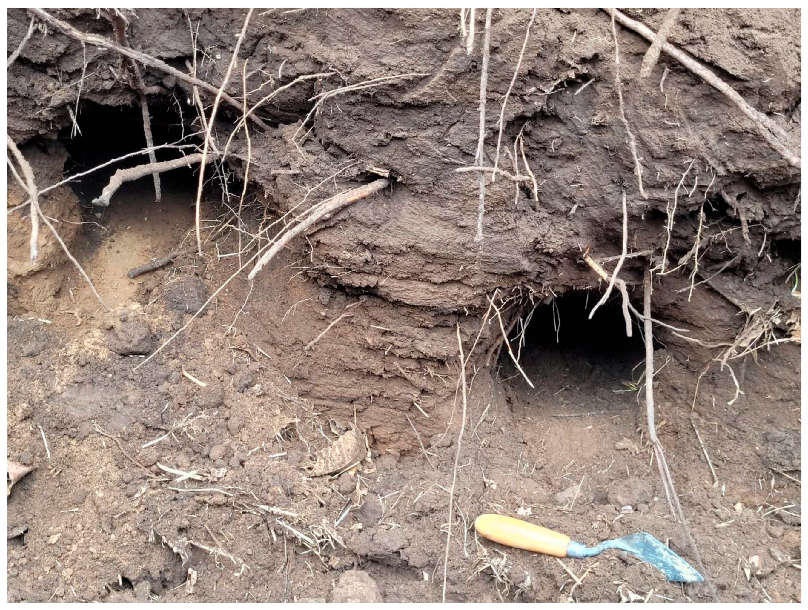
Figure 5.
The image shows how, following the stratigraphic archaeological excavation, the GPR anomaly shown in Figure 4C,D turned out to be a series of underground tunnels dug by local wildlife.
The final stage of the investigation involved the use of cadaver dogs trained to detect the scent of human remains. The K9 units conducted thorough sweeps of each site; however, their alerts and signals were minimal, interpreted directly by the certified handler, as per operational protocol. This weak signal was detected, which, after excavation (Figure 5), was found to be unrelated to human remains and likely caused by animal activity.
Collectively, these methods—satellite imagery, reconnaissance, GPR, and K9 detection—provided a comprehensive assessment, ultimately leading to the conclusion that no human remains were present at the identified sites. This multilayered approach highlighted the importance of integrating diverse forensic techniques to ensure thorough and reliable findings, particularly in cases where the absence of expected evidence played a pivotal role in the investigative and judicial context.
3.2. Findings from Phase 2
No evidence of human remains was found in the witness-revised “drop” area, reinforcing the reliability of the systematic protocol in thoroughly confirming the absence of burial evidence. This outcome highlights the effectiveness of the structured, phased approach in excluding potential sites with a high degree of certainty. The lack of findings, despite advanced techniques such as GPR and K9 units, demonstrates that the protocol is robust enough to yield clear, scientifically sound conclusions, even in challenging cases where conclusive evidence is not discovered. By systematically ruling out these locations, the investigative team was able to save and redirect resources with greater confidence, ultimately supporting the accuracy and credibility of forensic conclusions within judicial processes.
3.3. Statistical Validation of a Priori Evidence Table
The probabilistic approach, enhanced through Bayesian inference, demonstrated a low likelihood of a burial in the investigated areas and validated the decision to cease further investigative efforts in these locations, as the cumulative evidence strongly suggested an absence of human remains. Bayesian inference allowed investigators to qualitatively weigh both positive and negative findings, creating a more reliable basis for concluding the investigation without additional exploration. By integrating probabilistic reasoning, the team could confidently interpret the lack of evidence as meaningful, underscoring the precision and reliability of the systematic protocol. This approach also demonstrates how advanced statistical methods can enhance forensic investigations by providing rigorous guidance for decision-making, even in cases where direct evidence remains elusive.
4. Discussion
Although this investigation was based on a single case with a negative outcome, it nonetheless provides valuable methodological insights. The structured protocol outlined here was not intended to guarantee detection in every case but to offer a reproducible framework for optimizing search strategies across varying forensic conditions. Its modular nature allows investigators to adjust the sequence and weighting of each method—e.g., prioritizing K9 use in soft soils or emphasizing satellite imagery in inaccessible terrains. Similarly, the Bayesian inference model embedded in the a priori table allows for adaptation based on case-specific variables such as time elapsed since death or the quality of witness information. These considerations support the model’s potential applicability to other complex forensic contexts, even beyond cold-case investigations.
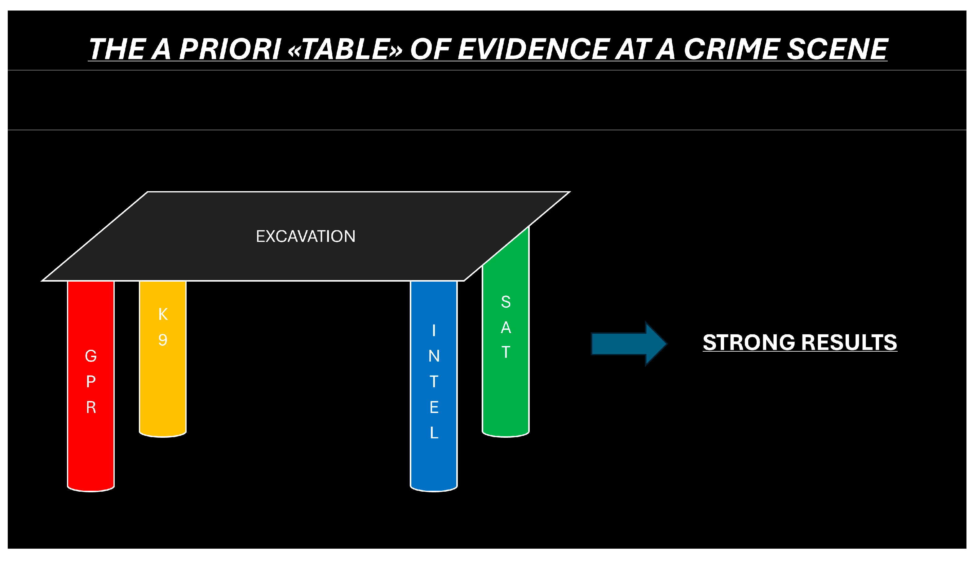
The investigation of suspected burial sites employed a multidisciplinary, systematic approach that proved invaluable in assembling a clear and reliable assessment of each site. At the center of this method was the “a priori evidence table,” a structured tool designed to integrate and evaluate data from multiple sources, ensuring a comprehensive review of all available evidence. This approach brought together diverse methods, each contributing unique insights and compensating for the limitations of others. Together, these sources were input into the “a priori table,” which scored the likelihood of each site containing a burial (Figure 6). The four main investigative pillars of the table—satellite imagery, GPR, K9 scent detection, and intelligence or witness accounts—formed the foundation of this integrated model. Each component contributed critical yet distinct data, either supporting the need for more invasive physical investigations (e.g., excavation) or justifying the exclusion of a site from further investigation. While each technique targets different forensic markers, their sequential use was not arbitrary but informed by prior data—including remote sensing outputs—and logistical realities of terrain and site access. The integration of satellite imagery and geoarchaeological criteria as a guiding layer for prioritizing subsurface methods is both innovative and increasingly documented in international forensic protocols.
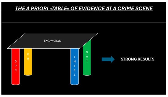
Figure 6.
The a priori evidence table integrates multiple sources of information—including satellite imagery, GPR anomalies, K9 alerts, and witness or intelligence inputs—to evaluate the probability of buried human remains at each site. Each source is assigned a specific weight, and the resulting probabilistic score is iteratively updated using Bayesian inference. Positive indicators increase the overall likelihood, while ambiguous or negative inputs reduce it. This structured scoring system supports systematic, evidence-based prioritization of excavation areas and enhances the efficient use of investigative resources. A practical example illustrating this model with anonymized numerical data is provided in Appendix A.
Satellite imagery, although incapable of delivering definitive conclusions on its own, played a crucial role in identifying patterns or anomalies that narrowed the focus of on-site efforts. It offered an initial overview, helping investigators prioritize specific locations for further investigation with GPR and K9 units. Satellite images could, for example, reveal disturbances in vegetation or changes in terrain that aligned with potential burial sites, making them a valuable preliminary screening tool.
Once potential areas were identified, GPR was employed to provide a non-invasive means of examining the subsurface. GPR technology allowed for the detection of subsurface anomalies by creating radargrams that indicated disruptions in soil layers. Although GPR was effective in highlighting areas of interest, it did face challenges. Soil composition, terrain irregularities, and environmental conditions could sometimes obscure readings, complicating the interpretation of results. Additionally, some of the anomalies detected were ambiguous, as they could result from natural factors or human activity unrelated to burials. By integrating GPR data into “the a priori table”, investigators could cross-check these findings against other sources, refining the probability scores assigned to each site and preventing over-reliance on a single method.
K9 units further strengthened this investigatory model by providing a scent-based approach to locating human remains. Canine scent detection can be particularly effective due to the dogs’ highly sensitive olfactory abilities, offering a direct indication of potential remains. However, the effectiveness of the K9 units was impacted by several environmental and temporal factors. The significant time lapse since the suspected burial event (approximately 16 years), combined with environmental changes, such as woodland restoration and vegetation management, likely reduced the availability of scent markers. Despite these limitations, K9 indications remained valuable, as positive alerts added significant weight to a site’s probability score within the a priori table.
The fourth leg of the investigation—intelligence reports and witness statements—provided a qualitative layer to complement the technological findings. Witness accounts helped direct initial search efforts, especially in cases where historical knowledge or personal testimonies could indicate potential sites. However, due to the long period since the event, witness memory was understandably less reliable, underscoring the need to corroborate statements with other evidence sources. By assigning controlled probabilistic values to witness information within “the a priori table”, investigators ensured that while valuable, these accounts did not disproportionately influence decisions without verification.
At the core of the “a priori table” was a Bayesian inference model, which assigned probabilistic values to the findings from each investigative source and allowed for dynamic updates as new data became available. The higher the values for a given site, the more stable “the table” became, indicating a stronger likelihood of the need for excavation. This Bayesian approach enabled investigators to evaluate the cumulative probability of each site’s relevance based on the strength of positive or negative indications from each leg. Sites with consistent positive findings across multiple sources received higher likelihood scores, signaling them as priority areas for further exploration. In contrast, ambiguous or negative results across sources contributed to lower likelihood scores, allowing investigators to confidently deprioritize those sites.
The scientific innovation of this approach lies in translating complex forensic decision-making into an operational framework grounded in probabilistic reasoning. While each technique employed has been previously validated in forensic literature, their coordinated use within a standardized, statistically guided architecture represents a methodological advance. The a priori table not only facilitates transparent prioritization of investigative effort but also enables retrospective evaluation and procedural reproducibility—key criteria for forensic rigor. This framework is particularly suited to large-scale searches where resources are limited and the risk of false positives or negatives is elevated.
The multidisciplinary approach of combining these diverse methods through the a priori table was not without challenges. GPR data, for example, occasionally produced ambiguous readings due to natural soil and terrain variations that made interpretation difficult. K9 units faced reduced effectiveness due to scent degradation, and witness statements were limited by the passage of time. Yet, the integrated nature of the a priori table allowed for these challenges to be managed effectively. By cross-referencing data and adjusting probability scores based on both positive and negative indications, investigators were able to mitigate the limitations of each method and enhance the reliability of their assessments. Rather than interpreting the outcome as a procedural failure, the investigation demonstrates how a well-structured methodology can effectively guide the exclusion of unsubstantiated sites. This ability to discriminate areas of low forensic interest—based on converging negative indications from satellite imagery, GPR, K9, and witness evaluation—is a core strength of the protocol. In forensic search operations, particularly over large and complex terrains, the capability to prioritize or eliminate locations with scientific justification is critical to conserving time and resources while maintaining evidentiary rigor. The present case, therefore, serves as a demonstration of procedural efficiency and decision-making clarity, even in the absence of a confirmed burial. Although some sites yielded negative findings, these results proved essential in advancing the investigation and saving valuable time. Through the systematic elimination of unsubstantiated areas, the team avoided misallocating resources and concentrated efforts on sites with higher likelihood scores. This methodical exclusion of unlikely sites underscored the value of negative findings, which, when rigorously verified, contribute to investigative clarity and judicial integrity. The “a priori table” ensured that each site was either validated or excluded through a scientifically robust process, highlighting the critical role structured negative findings play in forensic investigations.
In addition to refining resource allocation, this method underscored the importance of standardized protocols in forensic investigations. The a priori table, with its standardized approach, provided a framework that could be applied consistently, reducing subjectivity and enhancing both reliability and legal defensibility. This protocol-based model not only increases the credibility of forensic conclusions but also supports efficient resource management, ensuring scientifically sound results that hold weight within the judicial system. To address the need for practical clarity, we have supplemented this manuscript with a sample “a priori evidence table” (Appendix A), which demonstrates how values were operationalized in this case. The table includes specific probabilistic values and source weights, along with their aggregation into a final likelihood score. This addition directly addresses concerns about the table’s usability, making explicit the logic that guided excavation decisions and exclusion zones. It also exemplifies how similar probabilistic frameworks could be adjusted depending on terrain, case history, or investigative phase.
Ultimately, the case highlighted how advanced statistical reasoning, combined with a multidisciplinary investigative framework, allows for a nuanced, data-driven approach to forensic investigations. Bayesian inference, as applied through the “a priori table”, provided a robust platform for integrating diverse evidence sources, creating a probabilistic foundation for decision-making that balanced both positive and negative findings. Despite the absence of direct evidence, investigators were able to draw meaningful conclusions with a high degree of confidence by utilizing this structured approach.
This case demonstrated the value of integrating probabilistic reasoning with multidisciplinary forensic methods, particularly when direct evidence may be elusive or degraded over time. By leveraging the strengths of GPR, K9 units, satellite imagery, and intelligence within a unified protocol, the investigative team was able to navigate the complexities of the case with rigor. The “a priori table” proved to be an invaluable asset in making informed, data-driven decisions that ensured the investigation’s integrity and effectiveness. This model not only guided the current case but also offers a replicable framework for future forensic investigations, highlighting the critical role of standardized, evidence-based approaches in advancing judicial clarity and resource efficiency in forensic science.
5. Conclusions
The investigation into this cold case ultimately yielded no evidence of human remains; however, the structured, multidisciplinary, and phased protocol applied here ensured that all potential burial sites were thoroughly examined and conclusively validated the absence of remains in the designated areas. This comprehensive approach highlighted the critical value of employing a consistent forensic methodology that integrates diverse investigative techniques. By combining satellite imagery, GPR, and K9 units within a standardized framework, investigators were able to systematically rule out unsubstantiated locations with confidence, adding both clarity and efficiency to the judicial process.
This case report advocates for the adoption of a comprehensive, standardized forensic protocol in the investigation of suspected clandestine burials—particularly in countries like Italy, where such systematic approaches are still rarely implemented. The structured integration of multiple methodologies enables consistent evaluation of both positive and negative findings, thereby enhancing the overall reliability of the investigation. Standardization reduces the potential for misinterpretation, optimizes resource allocation by focusing efforts on scientifically validated areas, and strengthens the evidentiary foundation of the case. In judicial settings, a transparent and reproducible protocol increases the credibility of forensic results, making them more robust and defensible in court. This contributes to reinforcing the integrity, efficiency, and accountability of the broader forensic and judicial systems. Moreover, in the context of long-running investigations with potential ties to organized crime, the ability to systematically exclude sites through a transparent, evidence-based methodology has significant operational and judicial value. Particularly in regions with a complex socio-cultural landscape, such as areas historically affected by mafia presence, demonstrating that specific locations do not contain buried remains is a result in itself—one that can support closure, redirect resources, and provide strategic clarity for law enforcement.
In conclusion, although no remains were located, the investigation underscores the critical importance of applying standardized, multidisciplinary procedures not only to detect buried remains but also to systematically rule out unlikely sites. The true strength of the proposed protocol lies in its capacity to assess multiple evidence streams in a coordinated and replicable fashion, enabling the identification and prioritization of target areas while excluding others with high reliability. This approach minimizes investigative bias, supports forensic transparency, and enhances the interpretive value of both positive and negative findings within judicial contexts. The case demonstrates that negative findings are not only valuable but essential for judicial clarity, as they prevent unnecessary expenditure of time and resources while enabling investigators to draw scientifically sound conclusions. We acknowledge that the absence of a confirmed burial site may limit the perceived evidentiary value of the applied methods. However, the core objective of this study was to demonstrate the systematic integration of technologies and data sources in forensic search strategy design. The example provided in Appendix A could serve as a foundation for future studies, helping to strengthen the interpretive framework and validate detection thresholds in diverse forensic scenarios.
This approach reinforces the need for methodical, validated techniques in modern forensic science, proving that even in the absence of physical evidence, rigorously conducted investigations contribute meaningfully to the pursuit of justice.
Author Contributions
Conceptualization, P.M.B. and E.D.L.; methodology, P.M.B. and E.D.L.; software, P.M.B.; validation, P.M.B. and E.D.L.; formal analysis, P.M.B. and E.D.L.; investigation, P.M.B. and E.D.L.; resources, P.M.B. and E.D.L.; data curation, P.M.B. and E.D.L.; writing—original draft preparation, P.M.B.; writing—review and editing, P.M.B. and E.D.L.; visualization, P.M.B. and E.D.L.; supervision, P.M.B. and E.D.L.; project administration P.M.B. and E.D.L. All authors have read and agreed to the published version of the manuscript.
Funding
This research received no external funding.
Institutional Review Board Statement
Not applicable.
Informed Consent Statement
Not applicable.
Data Availability Statement
The raw data supporting the conclusions of this article will be made available by the authors on request.
Acknowledgments
The authors warmly thank Procura della Repubblica di Vibo Valentia (C. Falvo e E. Belmonte), Arma dei Carabinieri personnel belonging to S.I.O.—R.I.S. Carabinieri Messina and Nucleo Cinofili Carabinieri di Bologna for their effort, support and guidance during the operations.
Conflicts of Interest
The authors declare no conflicts of interest.
Appendix A
This table presents an example of the a priori evidence evaluation used to assess potential burial sites based on a combination of satellite imagery, GPR anomalies, K9 detection signals, and witness testimony.

Table A1.
Example of the A Priori Evidence Table.
Table A1.
Example of the A Priori Evidence Table.
| Site ID | Satellite Imagery | GPR Anomaly | K9 Detection | Witness Testimony | Weighted Score (%) | Decision |
|---|---|---|---|---|---|---|
| S1 | Minor disturbance (0.3) | No anomaly (0.1) | No alert (0.1) | Uncertain (0.2) | 17% | Excluded |
| S2 | Strong anomaly (0.8) | Clear void (0.9) | Moderate alert (0.6) | Strong match (0.9) | 81% | Excavated |
| S3 | No anomaly (0.1) | Possible void (0.5) | No alert (0.1) | Moderate match (0.5) | 42% | Reserved |
| S4 | Vegetation change (0.6) | No anomaly (0.1) | Mild alert (0.3) | Unreliable (0.1) | 28% | Excluded |
| S5 | Moderate change (0.4) | Strong anomaly (0.8) | Strong alert (0.9) | Strong match (1.0) | 88% | Excavated |
| Site ID | Satellite Imagery | GPR Anomaly | K9 Detection | Witness Testimony | Weighted Score (%) | Decision |
Each source is weighted, and a cumulative probability score is calculated to support decision-making as following:
Weighting system applied:
- -
- Satellite Imagery: 20%
- -
- GPR Anomaly: 30%
- -
- K9 Detection: 30%
- -
- Witness Testimony: 20%
Interpretation thresholds:
- -
- >70%: Strong indication → Excavated
- -
- 40–70%: Moderate indication → Reserved
- -
- <40%: Weak indication → Excluded
References
- Bakhtiar, H. Utilization of Forensic Evidence in the Criminal Justice System. In Proceedings of the International Conference on Law Studies (INCOLS 2022); Atlandis Press: Dordrecht, The Netherlands, 2022; pp. 237–245. ISBN 978-2-494069-22-0. [Google Scholar]
- Mohsin, D.K. The Significance of Forensic and Scientific Evidence and Their Admissibility in Criminal Law; SSRN: Rochester, NY, USA, 2024. [Google Scholar]
- Peterson, J.; Sommers, I.; Baskin, D.; Johnson, D. The Role and Impact of Forensic Evidence in the Criminal Justice Process; U.S. Department of Justice: Washington, WA, USA, 2010. [Google Scholar] [CrossRef]
- Stoel, R.D.; Sjerps, M. Interpretation of Forensic Evidence. In Handbook of Risk Theory: Epistemology, Decision Theory, Ethics, and Social Implications of Risk; Roeser, S., Hillerbrand, R., Sandin, P., Peterson, M., Eds.; Springer: Dordrecht, The Netherlands, 2012; pp. 135–158. ISBN 978-94-007-1433-5. [Google Scholar]
- Harrison, K. Is Crime Scene Examination Science, and Does It Matter Anyway? Sci. Justice 2006, 46, 65–68. [Google Scholar] [CrossRef] [PubMed]
- Koehler, J.J.; Mnookin, J.L.; Saks, M.J. The Scientific Reinvention of Forensic Science. Proc. Natl. Acad. Sci. USA 2023, 120, e2301840120. [Google Scholar] [CrossRef] [PubMed]
- Lander, E.; Press, W.; Gates, J.S.; Graham, S.L.; McQuade, M.J.; Schrag, D. Report to the President: Forensic Science in Criminal Courts: Ensuring Scientific Validity of Feature-Comparison Methods; PCAST, Ed.; CreateSpace Independent Publishing Platform: Scotts Valley, CA, USA, 2016; ISBN 978-1-5391-7200-0. [Google Scholar]
- Willis, S.; Kenna, L.; Dermott, S.; Donnell, G.; Barrett, A.; Rasmusson, B.; Nordgaard, A.; Berger, C.; Sjerps, M.; Molina, J.; et al. ENFSI Guideline for Evaluative Reporting in Forensic Science; ENFSI: Wiesbaden, Germany, 2015. [Google Scholar]
- Donnelly, L. A Standard Operating Procedure (SOP), for Soil Sampling, for the Detection of Volatile Organic Compounds and Leachate Associated with Human Decomposition from a Shallow, Unmarked, Homicide Grave. In Forensic Soil Science and Geology; Fitzpatrick, R.W., Donnelly, L.J., Eds.; Geological Society of London: London, UK, 2021; ISBN 978-1-78620-455-4. [Google Scholar]
- Osman, K.; Francesca, G.; Hamzah, N.H. Crime Scene Investigation Issues: Present Issues and Future Recommendations. J. Undang. Dan Masy. 2021, 28, 3–10. [Google Scholar] [CrossRef]
- Chowdhury, M. Beyond Bagging and Tagging—An Empirical Investigation into the Roles, Designations and Responsibilities of Crime Scene Practitioners. Sci. Justice 2021, 61, 271–279. [Google Scholar] [CrossRef] [PubMed]
- Barone, P.; Di Maggio, R.; Ferrara, C. Forensic Geo-Archaeology in Italy: Materials for a Standardisation. Int. J. Archaeol. 2015, 3, 45–56. [Google Scholar] [CrossRef]
- Di Luise, E.; Magni, P.A. Interim Recommendations for the Management of Forensic Investigation during the COVID-19 Pandemic: An Italian Perspective. Sci. Justice 2021, 61, 735–742. [Google Scholar] [CrossRef] [PubMed]
- Pulice, I.; Leo, P.D.; Robustelli, G.; Scarciglia, F.; Cavalcante, F.; Belviso, C. Weathering in Pleistocene Badlands from Ionian Calabria, Southern Italy. Alp. Mediterr. Quat. 2011, 24, 123–125. [Google Scholar]
- Barone, P.M.; Groen, W.M. (Eds.) Forensic Archaeology and New Multidisciplinary Approaches: Topics Discussed During the 2018–2023 European Meetings on Forensic Archaeology (EMFA); Soil Forensics; Springer Nature: Cham, Switzerland, 2025; ISBN 978-3-031-86307-3. [Google Scholar]
- Barone, P.M. Forensic Geophysics. In Geoscientists at Crime Scenes: A Companion to Forensic Geoscience; Di Maggio, R.M., Barone, P.M., Eds.; Soil Forensics; Springer International Publishing: Cham, Switzerland, 2017; pp. 175–190. ISBN 978-3-319-58048-7. [Google Scholar]
- Elmes, G.A.; Roedl, G.; Conley, J. (Eds.) Forensic GIS: The Role of Geospatial Technologies for Investigating Crime and Providing Evidence; Geotechnologies and the Environment; Springer: Dordrecht, The Netherlands, 2014; ISBN 978-94-017-8756-7. [Google Scholar]
- Barone, P.M.; Di Maggio, R.M. Dealing with Different Forensic Targets: Geoscientists at Crime Scenes. Geol. Soc. Lond. Spec. Publ. 2021, 492, 87–94. [Google Scholar] [CrossRef]
- Pringle, J.K.; Stimpson, I.G.; Wisniewski, K.D.; Heaton, V.; Davenward, B.; Mirosch, N.; Spencer, F.; Jervis, J.R. Geophysical Monitoring of Simulated Clandestine Burials of Murder Victims to Aid Forensic Investigators. Geol. Today 2021, 37, 63–65. [Google Scholar] [CrossRef]
- Barone, P.M.; Groen, W.J.M. (Eds.) Multidisciplinary Approaches to Forensic Archaeology: Topics Discussed during the European Meetings on Forensic Archaeology (EMFA); Soil Forensics; Springer International Publishing: Cham, Switzerland, 2018; ISBN 978-3-319-94396-1. [Google Scholar]
- Di Maggio, R.M.D.; Barone, P.M. (Eds.) Geoscientists at Crime Scenes: A Companion to Forensic Geoscience; Soil Forensics; Springer International Publishing: Cham, Switzerland, 2017; ISBN 978-3-319-58047-0. [Google Scholar]
- Barone, P.M.; Matsentidi, D.; Mollard, A.; Kulengowska, N.; Mistry, M. Mapping Decomposition: A Preliminary Study of Non-Destructive Detection of Simulated Body Fluids in the Shallow Subsurface. Forensic Sci. 2022, 2, 620–634. [Google Scholar] [CrossRef]
- McKinley, J.; Ruffell, A.; Harrison, M.; Meier-Augenstein, W.; Kemp, H.; Graham, C.; Barry, L. Spatial Thinking in Search Methodology: A Case Study of the ‘No Body Murder Enquiry’, West of Ireland. In Criminal and Environmental Soil Forensics; Ritz, K., Dawson, L., Miller, D., Eds.; Springer: Dordrecht, The Netherlands, 2009; pp. 285–302. ISBN 978-1-4020-9204-6. [Google Scholar]
- Rocke, B.; Ruffell, A. Detection of Single Burials Using Multispectral Drone Data: Three Case Studies. Forensic Sci. 2022, 2, 72–87. [Google Scholar] [CrossRef]
- Abate, D.; Sturdy Colls, C.; Moyssi, N.; Karsili, D.; Faka, M.; Anilir, A.; Manolis, S. Optimizing Search Strategies in Mass Grave Location through the Combination of Digital Technologies. Forensic Sci. Int. Synerg. 2019, 1, 95–107. [Google Scholar] [CrossRef] [PubMed]
- Moran, K.S.; Gold, C.L. (Eds.) Forensic Archaeology: Multidisciplinary Perspectives; Springer International Publishing: Cham, Switzerland, 2019; ISBN 978-3-030-03289-0. [Google Scholar]
- Groen, W.J.M.; Mrquez-grant, N.; Janaway, R.C. Forensic Archaeology: A Global Perspective, 1st ed.; Blackwell Pub: New York, NY, USA, 2015; ISBN 978-1-118-74598-4. [Google Scholar]
- Alexander, M.B. The Forensic Application of Soil: Clandestine Graves and Human Remains Detection Dogs. Ph.D. Thesis, Texas A&M University, College Station, TX, USA, 2014. [Google Scholar]
- Ruffell, A.; Mckinley, J.; Donnelly, L.; Harrison, M.; Keaney, A. Geoforensics, 1st ed.; John Wiley & Sons Inc.: Chichester, UK; Hoboken, NJ, USA, 2008; ISBN 978-0-470-05735-3. [Google Scholar]
- Kruse, C. The Bayesian Approach to Forensic Evidence: Evaluating, Communicating, and Distributing Responsibility. Soc. Stud. Sci. 2013, 43, 657–680. [Google Scholar] [CrossRef]
- Taroni, F.; Aitken, C.; Garbolino, P.; Biedermann, A. Bayesian Networks and Probabilistic Inference in Forensic Science, 1st ed.; Wiley: Chichester, UK; Hoboken, NJ, USA, 2006; ISBN 978-0-470-09173-9. [Google Scholar]
- Taroni, F.; Bozza, S.; Biedermann, A.; Garbolino, P.; Aitken, C. Data Analysis in Forensic Science: A Bayesian Decision Perspective, 1st ed.; Wiley: Chichester, UK, 2010; ISBN 978-0-470-99835-9. [Google Scholar]
- Martin, C.; Diederich, C.; Verheggen, F. Cadaver Dogs and the Deathly Hallows—A Survey and Literature Review on Selection and Training Procedure. Animals 2020, 10, 1219. [Google Scholar] [CrossRef] [PubMed]
- Stejskal, S.M. Death, Decomposition, and Detector Dogs: From Science to Scene; CRC Press: Boca Raton, FL, USA, 2012; ISBN 978-1-4665-7858-6. [Google Scholar]

Disclaimer/Publisher’s Note: The statements, opinions and data contained in all publications are solely those of the individual author(s) and contributor(s) and not of MDPI and/or the editor(s). MDPI and/or the editor(s) disclaim responsibility for any injury to people or property resulting from any ideas, methods, instructions or products referred to in the content. |
© 2025 by the authors. Licensee MDPI, Basel, Switzerland. This article is an open access article distributed under the terms and conditions of the Creative Commons Attribution (CC BY) license (https://creativecommons.org/licenses/by/4.0/).