Abstract
Soil moisture (SM) is an important variable related to the health of terrestrial ecosystems, agriculture, the continental water cycle, etc. It also provides an opportunity for drought monitoring, flood forecasting, weather forecasting, and the calibration of hydrological models. This study aims to estimate the surface soil moisture at a high spatial resolution (10 m) by combining radar and optical remote sensing data and improving the spatial resolution and accuracy. Synthetic aperture radar (SAR) operates with the competence to acquire data in any weather condition. The SAR images were acquired by C-band SAR sensors in the VV polarization boarded on Sentinel-1 satellites and the optical images were obtained from a Sentinel-2 multispectral instrument. The main algorithm involves the retrieval of soil moisture using radar data through a change detection (CD) method that is somehow combined with the WCM (parameters include vegetation descriptors and model coefficients) to estimate the SM and reduce the effect of vegetation cover. The method is applied to 13 months of time-series satellite data, from 7 November 2019 to 20 October 2020, over Salamanca (western Spain) and is validated using field data acquired at a study site with the use of a TDR sensor. The results showed good accuracy between the retrieved and ground measurement soil moisture data (Root Mean Square Error (RMSE) of 0.053 /) and the obtained accuracy is promising compared to recent similar works.
1. Introduction
With the increase in population and excessive use of available water resources, many different parts of the world have experienced the phenomenon of water shortage and drought, which leads to dangers and adverse consequences such as the disruption of natural and human ecosystems. Due to the criticality of this issue and the discussion of water resource management, it is necessary to study soil moisture in different parts. Remote sensing technology is an effective way to understand the behavior of the world and evaluate changes on Earth, and of course, it provides a very powerful tool for describing the monitoring of soil moisture on a large scale near the Earth’s surface. Soil moisture is one of the basic components of the water cycle that affects the processes of infiltration, runoff, and evaporation. In addition, it modulates the energy exchange as well as the carbon exchange at the surface, which is influenced by a wide range of spatial factors: climate, meteorology, and hydrology [1].
With advances in remote sensing technologies, many algorithms for scheduling surface soil moisture depending on the use of light, especially reflection and thermal diffusion, and remote sensing radar, especially synthetic aperture radar (SAR), have been introduced in previous studies. In recent years, SAR satellite data have been used to estimate soil texture, surface roughness, and soil moisture. In addition to the fact that the recoveries are only sensitive to high soil, the information provided by them can be used to assess the root-soil moisture of the area, which is an important variable for climate prediction, drought analysis, and carbon cycle modeling [2,3]. SAR data also have limitations on surface soil moisture recovery because accurate information on surface soil moisture depends on the target parameters, such as surface roughness, vegetation, dielectric constant, and topography, and the radar characteristics, such as frequency, polarization, and incidence angle (θ). Various methods have been proposed in recent years. For microwave remote sensing, models depending on the type of data (active or inactive microwave) for bare and vegetated soil surfaces are presented.
The backscattering coefficient is a function of the physical and electrical properties of the soil surface and the characteristics of the radar (wavelength, polarization, and incidence angle). In addition, in the case of the vegetation soil surface, the backscattering coefficient depends on the amount of radiation reflected from the vegetation as well as the soil layers. In the case of vegetation soils, vegetation attenuation increases with vegetation water content. Therefore, the contribution of vegetation to the rear scattering coefficient, which is measured by an active sensor in a vegetative pixel, should be considered [4]. This model is naturally quasi-experimental because the model parameters are site-dependent and require calibration [5]. The water cloud model represents the canopy as a cloud of water droplets, and higher-order scattering contributions are neglected. Bindlish and Barros [5] incorporated the water cloud model to retrieve the soil moisture in the vegetated area. Xu et al. [6] utilized the water cloud model to remove the vegetation effect from the observed backscattering coefficient.
In this study, the soil moisture was estimated by two WCMs and the changes were performed using the active radar time-series data of the Sentinel-1 satellite, the Sentinel-2 optical data, and also the soil moisture data in nine different stations in the central part of Spain (Salamanca Province). The optical images used in this research have been used to eliminate the effect of vegetation on radar signals and the main processing has been performed on the radar data. The ground station data were used to validate the model outputs. The reason for choosing the WCM in this study is to eliminate the effect of land cover vegetation and also for the model to investigate changes in reducing the effect of surface roughness on radar data.
2. Materials and Method
2.1. Case Study
According to the objectives of this study, the main part of which is estimating the soil moisture in areas with agricultural use as well as simultaneous access to three types of data (radar, optical data, and ground measurement) and the joint coverage of these three types of data in a single image of remote sensing data, several areas were examined.
The priorities for selecting these areas are as follows:
- The soil moisture of the stations should be measured at a depth of 5 cm;
- A large part of the target area includes agricultural land;
- The stations are located in different vegetation;
- All the stations are in the same image of the radar and optical data.
According to surveys, a region in the province of Salamanca in the west of Spain was selected (Figure 1). Salamanca is a province in western Spain, in the western part of the Autonomous Community of Castile-Leon. The provincial capital is the city of Salamanca. The area of the province is 12,058 square kilometers. Agriculture and animal husbandry are prominent in this region. The reason for choosing this area in this study is the existence of the agricultural areas as well as the terrestrial data network with continuous data. The study area is located between the three cities of Salamanca, Valladolid, and Zamora, most of which include agricultural land. The dimensions of this area are 36 × 24 km.
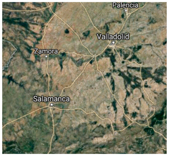
Figure 1.
Image related to the study area in the province of Salamanca, Spain.
2.2. Data Collection
According to the selected method, by reviewing previous studies on soil moisture estimation, the required data include radar and optical data and ground measurements. Radar data were used in the change detection model to estimate the soil moisture using the backscatter of radar signals, and optical data were used to calculate the vegetation indices to remove the effect of ground cover vegetation from the radar signals. The soil moisture data measured at fixed ground stations were used to calibrate the model as well as validate the model results.
2.2.1. Radar Data
Sentinel-1A (S-1A) and Sentinel-1B (S-1B) were launched in April 2014 and April 2016, respectively, as part of the European Space Agency’s Copernicus program, which surveys and monitors the Earth’s surface. Operations are designed with environmental information in mind. Artificial aperture radars (SARs) are indifferent to weather conditions and allow for data to be retrieved at any time of the day or night. SAR sensors on each of these satellites, located 180 degrees apart on a simultaneous solar orbital plane, provide images at both the VV and VH polarizations in the C band.
In the present study, signals recorded at the VV polarization were used to calculate the soil moisture estimates. According to the studies by Karjalainen [7] and Chauhan [8], VH data have only limited potential for estimating soil moisture, especially as a result of their high sensitivity to volume dispersion, which depends a lot on the geometric alignment and vegetation characteristics.
The Sentinel-1 data were collected from 7 November 2019 to 20 October 2020. Several processing steps were performed on each image to extract the backscattering coefficient. These products are available from the Copernicus website (https://scihub.copernicus.eu). These processes are developed in the SNAP 9.0.0 software environment developed by the European Space Agency (ESA) for the radiometric and geometric calibration of Sentinel satellite images.
The pre-processing performed on the Sentinel-1 images includes the following:
- Radiometric calibration;
- Thermal noise removal;
- Terrain correction using SRTM DEM at 30 m.
2.2.2. Optical Data
Sentinel-2 is an Earth observation mission developed by the European Space Agency (ESA) and includes two multispectral imaging satellites, Sentinel-2A and Sentinel-2B. Sentinel-2A was launched in June 2015, followed by Sentinel-2B in March 2017. These satellites provide complete coverage of the Earth’s surface with repeated 5-day visits. The images are produced in 13 spectral bands that cover visible and mid-infrared wavelengths in three different spatial resolutions (10, 20, and 60 m). The optical images used for the present study were obtained from the USGS website at the French Territorial Data Center (https://earthexplorer.usgs.gov), which makes the data available in the so-called “Level-2A” format. These data were collected between 8 November 2019 and 18 October 2020. These data are co-registered in the ENVI 4.8 software environment with a quadratic polynomial compared to the first image.
The Sentinel-2 optical data were used in the calculation of the NDVI and EVI to calibrate the WCM to eliminate the effect of vegetation.
2.2.3. Ground Measurement
The International Soil Moisture Network is an international partnership to establish and maintain a global soil moisture database. This database is an essential tool for validating and improving global satellite products and land, climate, and hydrological models (https://ismn.geo.tuwien.ac.at/).
The in situ soil moisture data in this study were used as a reference for the validation of the soil moisture products recovered from the satellite sources. The ground measurements in Spain were obtained free of charge through the International Soil Moisture Network (ISMN). The data from the REMEDHUS network in Spain were used to validate the humidity obtained through the remote sensing data.
Because ground measurements were used to evaluate the quality of the products obtained from the Sentinel-1 images, the selection of the sites was performed by considering being in the common area between the Sentinel-1 and Sentinel-2 images in the study area. Also, the measurements were made at the stations at a depth of 5 cm above the soil surface. Therefore, the soil moisture data were collected from nine stations.
2.3. Method
In summary, the method used and the pre-processing and processing performed in this study to estimate soil moisture can be outlined in the following steps:
- Perform the pre-processing of the radar and optical images and calculate the NDVI and EVI.
- Calculate coefficients A and B related to the calibration of the WCM by the least squares method using the backscatter of the Sentinel-1 radar signals, NDVI and EVI obtained from the Sentinel-2 data, and soil moisture data measured at the ground stations.
- Calculate the backscatter of the radar signals from the soil surface by the WCM method, using the coefficients A and B obtained in step (2), backscatter of radar signal levels of Sentinel-1, and the NDVI and EVI obtained from the Sentinel-2 optical data.
- Retrieve soil moisture by change detection and using the backscatter of the soil surface radar data calculated in step (3) and the soil moisture data measured at the ground stations.
- Validate the change detection model results using the soil moisture data measured at the ground stations.
This method involves the retrieval of soil moisture using radar data through a change detection method that is somehow combined with the WCM. During the process of performing soil moisture estimation processes, 8 ground stations were used and the Granja G station was considered as a checkpoint. According to this method, which is compatible with the data characteristics of Sentinel-1, the backscatter of radar signals from the soil surface without vegetation and under the influence of vegetation is as follows:
is the surface backscatter; is the backscatter from the plant surface; is the backscatter from the soil surface; is the effect of vegetation on the backscattering from the soil surface (attenuation coefficient) (due to re-crossing on the return route, it has a power of 2) [9]; is the incidence angle; and are the vegetation descriptors that show the scattering and attenuation characteristics of the vegetation; and A and B are the model coefficients that depend on the vegetation descriptor and sensor configuration.
Vegetation indices such as the NDVI, EVI, NDWI, LAI, or other indices are used for parameters and . In this study, the NDVI and EVI were used for parameters and .
By performing pre-processing of the Sentinel-1 radar data, is obtained. According to the pixels associated with the ground stations, NDVI and EVI, and ground surface backscatter , with two scenarios and using least squares division, the A and B coefficients related to the WCM calibration were obtained. These two scenarios and calibration coefficients obtained can be seen in Table 1.

Table 1.
Calibration coefficients.
All the processing steps related to soil moisture retrieval were performed programmatically in the Matlab 2016a software environment. All the processes related to the removal of the vegetation effect and the estimation of soil moisture were performed according to the two scenarios mentioned.
Considering the two previous scenarios and the obtained coefficients, and the backscatter of the ground surface using Equations (3)–(5), the backscatter of the soil surface is obtained. Due to the time difference between two consecutive images, the roughness effect is greatly reduced, which is one of the reasons for using the method to detect changes in this issue. According to the output obtained from the WCM method, the minimum value of is related to the drier state specified for each pixel:
: the difference between backscatter on the date d and driest day. : the backscatter in pixel (i, j) on the date d obtained using Sentinel-1 and Sentinel-2 images. : the lowest backscatter value is associated with the driest day (according to the Sentinel-1 time-series data).
According to several experimental studies that show a linear relationship between changes in radar signal and changes in soil moisture [10,11],
: The soil moisture changes between day d and the driest day. The parameter is dependent on the NDVI.
As the NDVI increases, the signal sensitivity to soil moisture is expected to decrease [12,13]. This means that the difference between the backscatter on day d and the backscattering on the driest day is reduced due to the NDVI. The strongest variable in humidity is related to the difference between the wettest and driest states:
According to the defined conditions of , the most changes in the backscatter are as follows:
To calculate the equation f, taking into account the NDVI as well as the driest backscattering difference for each pixel, and subtracting the top 1% of the data with the highest backscattering difference, one line is fitted to the points that have the most , which can be seen in Figure 2 [14,15].
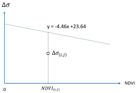
Figure 2.
Relationship between NDVI and backscatter difference.
The equation of this line is calculated by considering all the points in the time series of the Sentinel-2 radar data. Considering the largest backscattering difference in the different NDVIs, the equation f changes as follows [16]:
When the NDVI is zero, it corresponds to the largest open-point difference relative to the driest state on the surface of vegetation-free soil; in fact, .
Finally, the soil moisture in each pixel is estimated using the following formula [17]:
3. Experimental Results
In this part of this study, the output results of the soil moisture estimate model are presented according to the two scenarios mentioned in the previous chapter. Also, the evaluation of the results has been performed according to the ground stations for measuring the soil moisture, and the two scenarios for estimating the soil moisture have been compared with each other and the statistical indicators have been obtained.
For processing related to soil moisture estimation, two scenarios were considered in the vegetation removal section using the WCM, and further, the process of soil moisture estimation processing based on the change detection model has been performed for both scenarios. Soil moisture is estimated based on changes in pixel-by-pixel backscatter every day compared to the driest day of the period. According to Table 2, the image taken on 14 September 2020 is the driest day during the one year under review. Based on this, using 30 radar images, you have 29 outlets of soil moisture. The following is an example of the output of the model related to two scenarios and similar dates.

Table 2.
Statistical index values calculated at each station.
The outputs obtained from the model used to have an image size of 3600 × 2400 pixels, and each pixel has a spatial resolution of 10 m. These results have been validated using soil moisture measured by on-site soil moisture stations. The results obtained in the two scenarios show the correlation of the results with the values of the soil moisture measured by the ground stations. Table 2 lists the calculated values of the accuracy indicators.
One station has a very high RMSE compared to the other stations and the difference between the estimated and measured values of the soil moisture. According to the characteristics of this station, the vegetation on its surface is forest trees, which has a great effect on the radar signal.
The samples of the results from retrieving soil moisture in two scenarios (Table 3) in the study area are visible in the images above. In Figure 3 and Figure 4, the upper right and lower left sections exhibit denser vegetation compared to the other areas, as evidenced by the estimation of the soil moisture. Figure 5 depicts the driest day during the period under review.

Table 3.
Examining statistical indicators for two scenarios (*: by removing Las Bodega station).
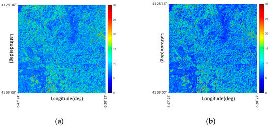
Figure 3.
Soil moisture results on 17 May 2020: (a) scenario 1 and (b) scenario 2 (color bar shows soil moisture values ).
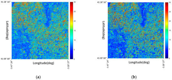
Figure 4.
Soil moisture results on 20 October 2020: (a) scenario 1 and (b) scenario 2 (color bar shows soil moisture values ).
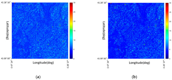
Figure 5.
Soil moisture results on 2 September 2020: (a) scenario 1 and (b) scenario 2 (color bar shows soil moisture values ).
The Granja G station, which is considered a check and according to the RMSE values calculated in this station, is close to the average RMSE of the other stations. Linear regression was performed between the two scenarios concerning the ground station data, and the determination coefficient (), RMSE, and mean absolute error (MAE) were calculated.
The soil moisture values of each station during the period under review and the RMSE calculated show the close performance of the two scenarios. As discussed in the previous section, at Las Bodega Station, due to the type of ground cover, there was a large difference between the values estimated by the model and the values of the soil moisture measured by the station. This difference increases the number of the RMSE in the evaluation of the model used. By deleting this station in calculating the statistical indicators and performing regression, significant changes are made in the model evaluation. The regression results, in this case, are as follows (Figure 6).
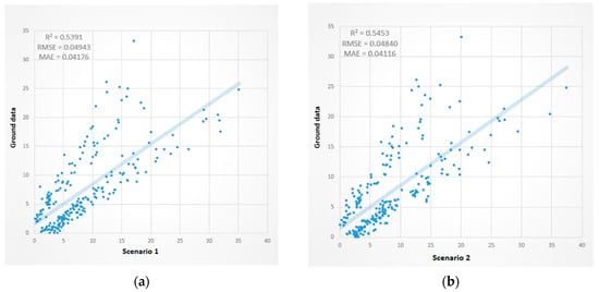
Figure 6.
Linear regression between the estimated soil moisture values of scenario 1 and the measured values at the stations (by removing Las Bodega station): (a) scenario 1 and (b) scenario 2. (RMSE unit:.
Table 3 shows the statistical indices and determination coefficient for the two scenarios in the two mentioned cases, which shows an increase in the output accuracy of the model by removing the Las Bodega station. In addition to increasing the RMSE, the absolute mean error also decreases.
4. Discussion
Based on previous studies, there are various methods for estimating soil moisture under vegetation, which can be obtained by combining different remote sensing data, such as radiometric, radar, thermal, and optical data. Different algorithms have been proposed and implemented. In this study, an attempt was made to improve the accuracy of estimating soil moisture in agricultural areas and also to increase the spatial accuracy of the final output of soil moisture. For this purpose, the radar data of the Sentinel-1 sensor as well as the optical data of the Sentinel-2 sensor with a spatial accuracy of 10 m have been used.
According to the results and methods used in this study, to estimate soil moisture without the use of ground data, it is necessary to calibrate the models used to eliminate the effect of vegetation in the study area. Also, during the processing process related to the change detection section, which uses soil moisture values, the soil moisture products of radiometer sensors can be used to replace the soil moisture used during the calculation process. Because the spatial accuracy of these sensors is very low, it reduces the accuracy of the soil moisture output obtained by the model.
The number of ground stations in the calibration process and calculations related to the soil moisture estimation model can be checked by performing calculations using the number of different ground stations in an area to check the number of optimal stations for estimating soil moisture. Other models such as the IWCM, which is an extended model of the WCM, or AIEM can also be used to eliminate the effect of vegetation and surface roughness to assess the impact on the accuracy of a soil moisture assessment and the use of different vegetation indicators in the calibration of these models.
5. Conclusions
Due to the selected method used in this study as well as studies that have been conducted in the past, models that use radar data have better accuracy than other models. Also, for vegetated areas, hybrid models perform better in accurately estimating soil moisture.
In this study, an effort has been made to improve the accuracy of soil moisture estimation in agricultural areas and also to increase the spatial accuracy of the final output of soil moisture. For this task, the radar data from the Sentinel-1 sensor and the optical data from the Sentinel-2 sensor, with a spatial accuracy of 10 m, were utilized. Based on past studies, radar signal backscatter is affected by changes in soil moisture, as well as by vegetation and soil roughness. Using the WCM, attempts have been made to mitigate the impact of vegetation on radar signals by utilizing suitable data. Because the change detection method is employed to estimate soil moisture, the alterations in soil roughness during the investigated time period are negligible and can be disregarded. The calibration of the WCM greatly impacts the accuracy of soil moisture estimation. This is achieved using the NDVI and EVI indicators obtained from the optical data of the Sentinel-2 sensor in conjunction with the soil moisture values measured by fixed stations.
In a study by Gao et al. (2017), the estimation of soil moisture in the agricultural region of northeastern Spain in the range of 20 × 20 km using two ground stations measuring soil moisture, the value of the determination coefficient () is equal to 0.099 and the value of the RMSE is equal to 0.087 (/) with a spatial resolution of 100 m. Also, in a study conducted by [18], which used Sentinel-1 radar data and MODIS optical data on an area similar to the study area in this dissertation, the RMSE value was obtained. It is equal to 0.055 (/). In this study, in addition to increasing the accuracy of the soil moisture estimation (RMSE) from 0.055 to 0.049 (/), the spatial accuracy also increased from 100 m to 10 m.
Author Contributions
Conceptualization, M.A. and R.S.-H.; Methodology M.A. and R.S.-H.; Project administration, M.A. and R.S.-H.; Resources, M.A. and R.S.-H.; Validation, M.A. and R.S.-H.; Supervision, R.S.-H. and O.G.; Writing—original draft, M.A. and R.S.-H.; Writing-review and editing, M.A., R.S.-H. and O.G. All authors have read and agreed to the published version of the manuscript.
Funding
This research received no external funding.
Institutional Review Board Statement
Not applicable.
Informed Consent Statement
Not applicable.
Data Availability Statement
The data can be accessed for free on the websites (https://scihub.copernicus.eu) and (https://ismn.geo.tuwien.ac.at/).
Conflicts of Interest
The authors declare no conflicts of interest.
References
- Yee, M.S.; Walker, J.P.; Monerris, A.; Rüdiger, C.; Jackson, T.J. On the identification of representative in situ soil moisture monitoring stations for the validation of SMAP soil moisture products in Australia. J. Hydrol. 2016, 537, 367–381. [Google Scholar] [CrossRef]
- Baldwin, D.; Manfreda, S.; Keller, K.; Smithwick, E. Predicting root zone soil moisture with soil properties and satellite near-surface moisture data across the conterminous United States. J. Hydrol. 2017, 546, 393–404. [Google Scholar] [CrossRef]
- Dumedah, G.; Walker, J.P.; Merlin, O. Root-zone soil moisture estimation from assimilation of downscaled Soil Moisture and Ocean Salinity data. Adv. Water Resour. 2015, 84, 14–22. [Google Scholar] [CrossRef]
- Attema, E.P.W.; Ulaby, F.T. Vegetation modeled as a water cloud. Radio Sci. 1978, 13, 357–364. [Google Scholar] [CrossRef]
- Bindlish, R.; Barros, A.P. Parameterization of vegetation backscatter in radar-based, soil moisture estimation. Remote. Sens. Environ. 2001, 76, 130–137. [Google Scholar] [CrossRef]
- Xu, L.; Li, J.; Niu, R. Soil moisture estimation over Jianghan plain using ENVISAT ASAR data. In Proceedings of the Internet Conference Multimedia Technology, Ningbo, China, 29–31 October 2010; pp. 1–4. [Google Scholar]
- Karjalainen, M.; Kaartinen, H.; Hyyppä, J.; Laurila, H.; Kuittinen, R. The Use of ENVISAT Alternating Ploarization SAR Images in Agricultureal Monitoring in Compatison with RADARSAT-1 SAR Images. In Proceedings of the ISPRS Congress, Istanbul, Turkey, 12–23 July 2004. [Google Scholar]
- Chauhan, S.; Srivastava, H.S. Comparative evaluation of the sensitivity of multi-polarized SAR and optical data for various land cover classed. Int. J. Remote Sens. 2016, 4, 1–14. [Google Scholar]
- Gupta, V.K.; Sharma, N.; Jangid, R.A. Emission and scattering behaviour of bare and vegetative soil surfaces of different moist states by microwave remote sensing. Indian J. Radio Space Phys. 2013, 42, 42–51. [Google Scholar]
- Srivastava, H.S.; Patel, P.; Sharma, Y.; Navalgund, R.R. Large-area soil moisture estimation using multi-incidence-angle RADARSAT-1 SAR data. IEEE Trans. Geosci. Remote Sens. 2009, 47, 2528–2535. [Google Scholar] [CrossRef]
- Baghdadi, N.; Cerdan, O.; Zribi, M.; Auzet, V.; Darboux, F.; El Hajj, M.; Kheir, R.B. Operational performance of current synthetic aperture radar sensors in mapping soil surface characteristics in agricultural environments: Application to hydrological and erosion modeling. Hydrol. Process. 2007, 22, 9–20. [Google Scholar] [CrossRef]
- Zribi, M.; Dechambre, M. A new empirical model to retrieve soil moisture and roughness from C-band radar data. Remote Sens. Environ. 2003, 84, 42–52. [Google Scholar] [CrossRef]
- Baghdadi, N.; Aubert, M.; Cerdan, O.; Franchistéguy, L.; Viel, C.; Martin, E.; Zribi, M.; Desprats, J.F. Operational Mapping of Soil Moisture Using Synthetic Aperture Radar Data: Application to the Touch Basin (France). Sensors 2007, 7, 2458–2483. [Google Scholar] [CrossRef] [PubMed]
- Santi, E.; Paloscia, S.; Pettinato, S.; Notarnicola, C.; Pasolli, E.; Pistocchi, A. Comparison between SAR Soil Moisture Estimates and Hydrological Model Simulations over the Scrivia Test Site. Remote Sens. 2013, 5, 4961–4976. [Google Scholar] [CrossRef]
- Liu, C. Analysis of Sentinel-1 SAR Data for Mapping Standing Water in the Twente Region. Master’s Thesis, University of Twente, Twente, The Netherlands, February 2016. Available online: http://www.itc.nl/library/papers_2016/msc/wrem/cliu.pdf (accessed on 22 May 2017).
- Zribi, M.; Andre, C.; Decharme, B. A method for soil moisture estimation in Western Africa based on the ERS scatterometer. IEEE Trans. Geosci. Remote Sens. 2008, 46, 438–448. [Google Scholar] [CrossRef]
- Gao, Q.; Zribi, M.; Escorihuela, M.J.; Baghdadi, N. Synergetic Use of Sentinel-1 and Sentinel-2 Data for Soil Moisture Mapping at 100 m Resolution. Sensors 2017, 17, 1966. [Google Scholar] [CrossRef] [PubMed]
- Han, Y.; Bai, X.; Shao, W.; Wang, J. Retrieval of Soil Moisture by Integrating Sentinel-1A and MODIS Data over Agricultural Fields. Water 2020, 12, 1726. [Google Scholar] [CrossRef]
Disclaimer/Publisher’s Note: The statements, opinions and data contained in all publications are solely those of the individual author(s) and contributor(s) and not of MDPI and/or the editor(s). MDPI and/or the editor(s) disclaim responsibility for any injury to people or property resulting from any ideas, methods, instructions or products referred to in the content. |
© 2024 by the authors. Licensee MDPI, Basel, Switzerland. This article is an open access article distributed under the terms and conditions of the Creative Commons Attribution (CC BY) license (https://creativecommons.org/licenses/by/4.0/).