Abstract
This research analyzed a sample of agricultural cultural landscapes recognized by United Nations agencies on the American continent, with the objective of study being the geographical delimitation established for each of the cultural properties. The results show the lack of “general considerations” that provide guidelines to carry out this activity, which consequently enables the protection of a territory and its management. It was identified that the perimeters of these cultural landscapes may have limits based on the following; geomorphological features, linear infrastructures, political–administrative limits, and if none of these limits are present then they are physically catalogued as vague or unclear. The establishment of general delimitation guidelines will allow the development of public policies for the organizing of such territory and a sustainable, dynamic, efficient, and resilient management for this type of living landscape.
1. Introduction
The cultural landscape is universally recognized as the result of the interaction between people and the natural environment over time. It is a territory perceived and valued for its cultural qualities; on account of the process and the support of the identity of a community [1].
In 1992, UNESCO incorporated the category of “cultural landscapes” into its Practical Guidelines for the application of the World Heritage Convention. Therefore, this Convention became the first international legal instrument to identify, protect, conserve, and transmit “cultural landscapes” to future generations [2]. In the year 2000, the Council of Europe approved the European Landscape Convention that was implemented in 2004, with the aim of promoting policies for the protection and management of European landscapes.
Specifically focused on agricultural cultural landscapes, it should be noted that in 2002, the Food and Agriculture Organization of the United Nations (FAO) launched a global collaboration initiative for the conservation and adaptive management of Globally Important Agricultural Heritage Systems (GIAHS), in response to alarming global trends threatening families of farmers and traditional farming systems [3].
It is therefore established that the cultural landscape can be subject to legal protection at the international level like any other territory and is therefore a generator of rights and obligations for public or private holders [4]. It should be remembered that many of these territories are “living landscapes” (according to UNESCO typology) that retain an active role in contemporary society, and closely linked to traditional ways of life for which the evolutionary process continues [5]. Therefore, the limits established at any given moment may shift [6], due to alterations in the abiotic, biotic, and/or anthropic subsystems and the interactions between them [7].
The relevance of analyzing this type of heritage assets lies in the need to establish physical limits that facilitate the preparation of an accurate cartography to promote international designation, and furthermore, the application of protective regulations thus insures that the competing margins of the different administrations are clear [8], and ultimately, these assets can be successfully managed.
This investigation analyzes different models of geographical limits used in America regarding agricultural cultural landscapes, as designated by specialized agencies of the United Nations.
2. Methodology
After a bibliographic review, it should be mentioned that international organizations have focused on the specification of criteria for the designation (identification and characterization) of cultural landscapes, but there is little information on their delimitations. It has only been possible to find certain pieces of information regarding the Coffee Cultural Landscape in Colombia [9].
The case studies analyzed for this particular study of whiche one is recognized by FAO 2018: the Chinampas Agricultural System in Mexico City [10] and then three cultural landscapes that are inscribed on the UNESCO World Heritage Lis., Grand-Pré in Canada in 2012 [11]; the Agavero Landscape and the Old Tequila Industrial Facilities in Mexico in 2006 [12]; and the Colombian Coffee Cultural Landscape in 2011 [13]. For each of these, an analysis of the nomination proposal was carried out, with special attention paid to the sections on the nominated property and buffer zone and those concerning the protection and management of the asset. In addition, a review of the cartography included in said proposals was carried out to identify which references were used to establish limits.
3. Results
The results of the analysis carried out on the case studies are grouped in two. The first is related to the determining factors that prompted the cartographic delimitation of agricultural cultural landscapes, which are: (1) the containment of the asset within the same political–administrative area, (2) the containment of the attributes of the asset within a unit geomorphological (valley, peninsula, mountains, etc.), and (3) conventional delimitations based on the area itself, without any other considerations than its own attributes.
The second group of results is related to the description of limits in the nomination proposal of said landscapes and the elements expressed in the cartography. Thus, it can be observed that the delimitation of the studied cultural landscapes involves the following criteria: (1) political–administrative limits, (2) limits marked by linear infrastructure, (3) limits defined by geomorphological units, and (4) vague or unclear limits, that is to say those that do not have any physical reference that allows a clear delimitation in the territorial space. These types of limits appear combined in the delimitations of the same landscape depending on the circumstances and the place. In this context, Figure 1 shows the four analyzed landscapes and their respective perimeters, which distinguish what types of criteria have been used in the delimitation of each section.
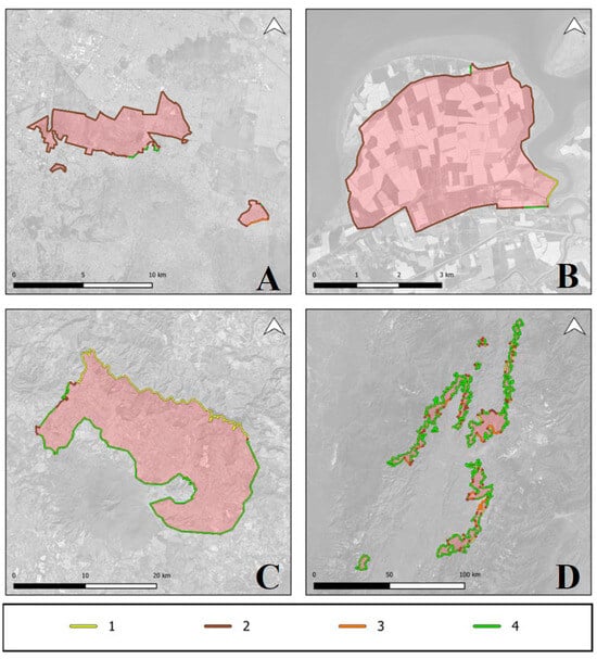
Figure 1.
Cartographic scheme of the four case studies analyzed: (A) Agricultural System of Chinampas (Mexico), (B) Cultural Landscape of Grand-Pré (Canada), (C) Agavero Landscape and Old Industrial Facilities of Tequila (Mexico), (D) Coffee Cultural Landscape (Colombia). (1) Defined limits of geomorphological units, (2) limits defined by linear infrastructure, (3) political–administrative limits, and (4) vague or unclear limits. Own elaboration based on public data from the denomination proposals [10,11,12,13].
The Agavero Landscape is contained within a valley, with the core zone being delimited by geographical accidents, according to its nomination proposal; however, only 35% of its perimeter allows reference to said delimitation. The delimitation of the Coffee Landscape focuses on an approach based on the area itself, using few physical references and comprising a perimeter that is 85% vague or unclear. In both cases, these areas cover territories that go beyond their municipal and even departmental (provincial) borders and there is little or no consideration for these. The Chinampas System shows that the protected property falls within the Federal State of Mexico City, despite the fact that the attributes of this landscape extend beyond these administrative limits. The perimeter for this landscape is defined by borders that follow the layout of linear infrastructure that covers 90% of the area, influenced by urban pressure and the water channels that it contains. A similar situation occurs in the landscape of Grand-Pré, as it is a peninsula enclosed by dikes (87% of the perimeter is covered by linear infrastructures).
Table 1 shows the criteria used most frequently for each of the cases studied in percentage terms.

Table 1.
Percentage of the limits of cultural landscapes according to their determining factors.
4. Discussion and Conclusions
In view of the bibliographic review and the analysis of the documents of international heritage institutions, it can be said that there is no official regulatory system or recommendations of universal application for the official delimitation of cultural landscapes.
The delimitation of agricultural cultural landscapes used in the case studies suggest that there is a direct relationship between the size of the protected cultural landscape and the percentage of diffuse delimitation it contains. Regarding geographic features, it can be assumed that the most stable element is a perimeter factor as long as it is a precise limit (watershed, cliff, etc.). In the case of vague or unclear limits, the convenient criteria would utilize the combination either of linear infrastructure, political–administrative or both. Often, the area itself guides the delimitation, but this can be a very limited dynamic boundary that does not take into consideration the natural, socio-economic, or cultural evolution of a living landscape, as has been observed in this analysis. Due to the nature of this landscape typology, it can be observed that a large number of private properties are concentrated within an area, which is not reflected or indicated in any way in the delimitation.
In addition to the elements that have determined the delimitation of agricultural cultural landscapes found in these case studies, it must be considered that there may be other factors (endogenous and/or exogenous) applicable to other scenarios. In this analysis it has not been detected consideration towards elements that: although not present at the time of nomination, have the potential to appear in the future under different anthropic conditions (e.g., uncultivated land) or ecosystem services. It should therefore be stressed that the non-consideration of these elements is detrimental to the organic evolution occurring in a given territory.
In summary, it could be said that the lack of delimitation of a cultural landscape constitutes an important vulnerability factor for the conservation and legal protection of these assets of exceptional universal value. For this reason, it is urgent to establish guidelines that facilitate their demarcation and respective considerations in order to promote the the stablishment of this type of patrimonial asset, and, above all, to make the sustainable, dynamic, efficient, and resilient management of these landscapes possible.
Author Contributions
Conceptualization, H.L.C. and M.J.V.; methodology, H.L.C. and M.J.V.; validation, H.L.C. and M.J.V.; formal analysis H.L.C. and M.J.V.; investigation, H.L.C. and M.J.V.; data curation, H.L.C. and M.J.V.; writing—original draft preparation, H.L.C. and M.J.V.; writing—review and editing, H.L.C. and M.J.V.; visualization, H.L.C. and M.J.V.; All authors have read and agreed to the published version of the manuscript.
Funding
This research received no external funding.
Institutional Review Board Statement
Not applicable.
Data Availability Statement
Data are contained within the article.
Acknowledgments
The authors of this paper would like to express their sincere thanks for the assistance received from Renan Rolim and Patricio Orozco.
Conflicts of Interest
The authors declare no conflicts of interest.
References
- Ministerio de Educación, Cultura y Deportes. Plan Nacional de Paisaje Cultural; Secretaría General Técnica, Subdirección General de Documentación y Publicaciones: Madrid, Spain, 2015. [Google Scholar]
- Rössler, M. Linking Nature and Culture: World Heritage Cultural Landscapes. In World Heritage Papers 7—Cultural Landscapes: The Challenges of Conservation; United Nations Educational, Scientific and Cultural Organisation (UNESCO): Ferrara, Italy, 2002; pp. 10–15. [Google Scholar]
- Veinte años de los Sistemas Importantes del Patrimonio Agrícola Mundial; Food and Agriculture Organization of the United Nations (FAO): Rome, Italy, 2023. [CrossRef]
- Moreno-Trujillo, E. El paisaje agrícola como patrimonio cultural: Bases legales para un análisis crítico. Rev. Int. de Doctrin. y Jurisprud. 2018, 18. [Google Scholar] [CrossRef]
- UNESCO. Guidelines for the inscription of properties on the List of World Heritage in Danger. In The Operational guidelines for the Implementation of the World Heritage Convention; UNESCO World Heritage Centre: Paris, France, 2021. [Google Scholar]
- Dudley, N. Directrices para la Aplicación de las Categorías de Gestión de Áreas Protegidas; UICN (Unión Internacional para la Conservación de la Naturaleza): Gland, Switzerland, 2008. [Google Scholar]
- Rigol Savio, I. Módulo 4 Gestión de Paisajes Culturales en Programa de Gestión; UNESCO: La Habana, Cuba, 2004. [Google Scholar]
- Ruíz, J.C. El Patrimonio agrario como marco de referencia de los paisajes culturales: Criterios para su delimitación y protección. Norba. Rev. de Arte 2022, 45–72. [Google Scholar] [CrossRef]
- Rincón Cardona, F. Paisaje Cultural Cafetero: Aspectos Teóricos y Metodológicos de una Experiencia Práctica; Instituto de Estudios Ambientales-IDEA: Manizales, Colombia, 2011. [Google Scholar]
- Government of Mexico City. Chinampa Agricultural System of Mexico City: A Proposal for Designation as Globally Important Agricultural Heritage Systems (GIAHS); Mexico City, Mexico, 2017. Available online: https://www.fao.org/3/I9159EN/i9159en.pdf (accessed on 20 April 2023).
- Ministry of Environment of Canada. World Heritage Nomination Proposal for The Landscape of Grand Pré; Nova Scotia, Canada, 2011. Available online: https://whc.unesco.org/uploads/nominations/1404.pdf (accessed on 20 April 2023).
- Government of Jalisco. The Agave Landscape and the Ancient Industrial Facilities of Tequila, Mexico; Guadalajara, Mexico, 2006. Available online: https://whc.unesco.org/uploads/nominations/1209.pdf (accessed on 20 April 2023).
- Ministry of Culture of Colombia. Coffee Cultural Landscape; an Exceptional Fusion of Nature, Collective Human Effort and Culture; Bogotá, Colombia, 2010. Available online: https://whc.unesco.org/uploads/nominations/1121.pdf (accessed on 20 April 2023).
Disclaimer/Publisher’s Note: The statements, opinions and data contained in all publications are solely those of the individual author(s) and contributor(s) and not of MDPI and/or the editor(s). MDPI and/or the editor(s) disclaim responsibility for any injury to people or property resulting from any ideas, methods, instructions or products referred to in the content. |
© 2023 by the authors. Licensee MDPI, Basel, Switzerland. This article is an open access article distributed under the terms and conditions of the Creative Commons Attribution (CC BY) license (https://creativecommons.org/licenses/by/4.0/).