Abstract
The aim of this study is to investigate the response of the rational method in flood hazard assessment in Potamia watershed of Thasos island, with climate data from Regional Climate Models. The precipitation intensity–duration–frequency (IDF) curves used were calculated using available EURO-CORDEX 0.11 regional climate model simulations, under the RCP8.5 scenario. The Corine Land Cover dataset was utilized for the determination of the runoff coefficient of the watershed and geomorphological and hydrographic characteristics are calculated using a Geographic Information System software. A comparison against actual flood events of the period 1991–2019, as mapped with satellite Synthetic Aperture Radar (SAR) imagery, is also carried out.
1. Introduction
Natural disasters such as floods and the consequent devastation they bring about are a widespread occurrence, affecting various regions across the globe. According to [1], the past three decades have witnessed the highest frequency of floods in the past 500 years, with notable increases occurring during the summer season. The Intergovernmental Panel on Climate Change’s (IPCC) Sixth Assessment Report (AR6) has highlighted that there is a growing threat of inundation and severe flooding in many regions, with the risk of these events expected to increase significantly. The report also warns that the number of individuals affected by precipitation and river flooding may double in the future [2].
Flooding is a significant issue in Greece, with many areas susceptible to the effects of heavy rainfall and flash floods. As reported by [3], approximately 75% of the country’s land area is characterized by hilly, semi-mountainous, and mountainous regions, which contribute to the occurrence of floods. A detailed study of these phenomena is essential, although in Mediterranean regions, particularly in medium and small watersheds with ephemeral streams, data is often lacking, as highlighted by [4].
The objective of this study is to assess the current and future flood hazard in Thasos Island, applying the rational method and utilizing climate data obtained from Regional Climate Models (RCMs). RCMs are advanced tools in climate science which are sophisticated mathematical representations of the atmosphere. They simulate the well-known dynamic and thermodynamic processes that govern the atmosphere comprehensively, as outlined in [5]. When it comes to dynamic downscaling, the effectiveness of the nested RCMs is greatly influenced by the quality of the lateral conditions of the driving Global Climate Model (GCM), as emphasized by [6]. In this study, RCMs are employed to assess and project the future trend of precipitation and Intensity-Duration-Frequency (IDF) curves.
The rational method is mentioned in the English Environment Agency’s (EA) review of methods for estimating flood peaks in small catchments [7]. Due to its suitability for small urban or impermeable catchments and its applicability in data-limited scenarios, the rational method is widely included in national and regional guidelines across the globe. This method employs variables such as rainfall intensity, drainage area, and a runoff coefficient to calculate the peak discharge.
2. Materials and Methods
2.1. Study Area
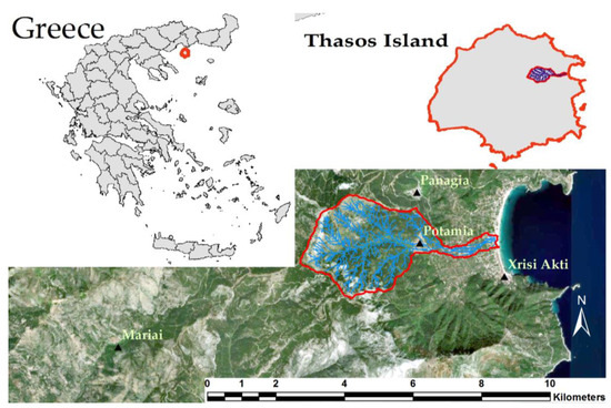
The island of Thasos is the northernmost island of the Aegean Sea, with a longitude ranging from 24°31′ to 24°47′ and a latitude ranging from 40°34′ to 40°48′. In this study, the rational method was applied in Potamia watershed, as illustrated in Figure 1. The Potamia basin has an area of 8.17 km2, with a maximum altitude of 1204 m. The main stream within the basin flows eastward, spanning a length of 6.85 km. The geological composition of the area mainly comprises gneisses, accounting for 29.25%. Additionally, smaller proportions of dolomite and marble horizons are also present in the region.

Figure 1.
Potamia watershed and its location within Thasos, Greece.
2.2. Data Collection
In this study, data from Euro CORDEX were utilized with a spatial resolution of 12 × 12 km. Three RCMs driven by six GCMs were used to produce Intensity-Duration-Frequency (IDF) curves for the timeframe spanning from 1970 to 2005, as well as the near and far future time periods of 2020–2055 and 2065–2210. These curves encapsulate the correlation between the intensity of precipitation and the duration of precipitation events for a specified frequency or return period. This paper examines the application of a simple but hydrologically robust method for streamflow estimation utilizing the Intensity-Duration-Frequency (IDF) curves derived from RCMs.
The observed values used for evaluation were obtained following the guidelines outlined in directive [8] using [9] methodology for country-level IDF drawing. A network of 54 weather stations over Greece (National Weather Service, Ministry of Environment and Energy, Ministry of Rural Development and Food) was utilized to gather time series data on annual maximum precipitation.
Satellite data were used to confirm with Satellite Synthetic Aperture Radar (SAR) images that the Potamia basin is flood-vulnerable and to identify past flood events. The applicability of SAR Remote Sensing for flood mapping, due to their cloud penetration capabilities as well as the overall independence of weather conditions and sun illumination, has been well established since the 1990s. Nevertheless, from 1991 until the advent of Europe’s Sentinel-1 satellite mission in 2014, SAR data acquisitions were relatively sparse and non-systematic, rendering their operational value for flood events quite limited, especially for flash-floods [10].
2.3. Geospatial Modeling
To accomplish this work ArcGIS software was utilized for the geomorphological analysis of the study region. The delineation of Potamia basin was conducted, and the morphometric and hydrographic attributes of the stream were assessed.
The Corine Land Cover 2018 [11] database was employed to analyze the land uses and calculate the runoff coefficient for the watershed. The runoff coefficient CN was determined using the methodology [12] provided by the United States Department of Agriculture-Natural Resources, which has also been adopted by the European Union in accordance with the directive [8].
The rational method can be described as a straightforward equation [13] establishing a relationship between peak discharge, catchment area, upstream land cover, and mean rainfall intensity for a storm of a specific return period through a link,
where Qp is peak discharge (m3/s), C is the runoff coefficient, which is a dimensionless number, i is the average storm rainfall intensity (mm/hr), and A is the watershed area (km2). The constant 0.287 is required to convert the original units from the North American system, where the model was first developed, to the SI (International System of Units) system.
Qp = 0.278 × C × I × A,
Regarding the remote sensing approach for flood mapping, the entire European Remote Sensing (ERS), Envisat, and Sentinel-1 archive of the European Space Agency (ESA) was investigated for suitable satellite SAR imagery, with respect to the known flood events on Thasos Island since 1991.
3. Results
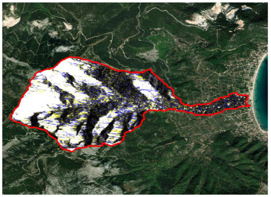
According to National databases, relevant studies [14,15], and public media, several flood events have been reported on Thasos Island during the last 30 years. Several of these have occurred in the vicinity of Potamia (Figure 1). Taking into account the reference period considered for this study (1970–2005), as well as the availability of satellite-based SAR data (1991 onwards), two indicative flash-flood events (in 2002 and 2019, respectively) were processed with multi-temporal SAR data (Figure 2), providing thus observational evidence on the flooding potential of the area.

Figure 2.
Indicative example of orthorectified multi-temporal satellite image (R,G,B: 27/11/19, 27/11/19, 21/11/19) composite from Sentinel-1 data (descending pass, VV, relative orbit: 7), for the 25–26 November 2019 floods. Blue pixels indicate the increased soil moisture in the post-flood scene.
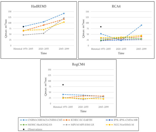
Figure 3 illustrates the peak water discharge estimated through the rational method (colored dots) and the observed values (black dots) over the Potamia watershed. The figure legend indicates the six GCMs (hereafter CNRM, ICHEC, IPSL, MOHC, MPI, NCC) driving the three RCMs (HadREM3, RCA4, RegCM4), the latter shown in the different panels. The X-axis indicates the three time periods considered in this study: 1970–2005 (historical), 2022–2055 (near future), and 2065–2099 (far future).

Figure 3.
Maximum water discharge (Qmax100) of observed data (black dot) and RCM climate simulations (color dots) driven by different GCMs, for the Potamia hydrological basin, on the island of Thasos.
The observed Qmax100 was found to be 83.4 m3/s. The peak discharge Qmax100 was systematically underestimated in all cases during the historical period, with the exception of the HadREM3 model driven by CNRM, which provided a quite accurate estimation (84.0 m3/s). The most severe underestimation was assessed with the use of the RegCM4 model followed by RCA4 (62% and 65% underestimation, respectively).
In the near future, the peak discharge exhibits an upward trend of 22% according to the HadREM3 regional model or remains the same according to RCA4 and RegCM4. Peak discharges range from 25 to 100 m3/s, indicating quite a large uncertainty. The behavior of the CNRM-RCA4 member is quite distinct, which indicates an abrupt decrease in Qmax100 57% in mid-century and a sharp increase 71% in the far future compared to the historical period.
In the far future, there is a notable increase in peak discharges when utilizing the HadREM3 model data (103–142 m3/s), irrespective of the GCM forcing. On the other hand, the peak discharges remain relatively constant for RCA4 (25–50 m3/s), and slightly decrease for RegCM4 (<32.5 m3/s).
4. Conclusions
In this study, an effort was made to assess the applicability of the Rational Method by incorporating climate data obtained from RCM simulations of the EURO-CORDEX database. The obtained results were then compared against the runoff values derived from observational data. The main conclusions are:
- Satellite (SAR) data indicate that the Potamia region is a watershed that has shown historical evidence of flooding.
- From a remote sensing perspective, the requirements for operational flash-flood mapping are even more demanding than the current state of the art. In particular, the availability of one high-resolution (10 m or better) SAR image per day would be a major improvement for small basins like in the case of Thasos, were the disastrous phenomena have a limited extent in space and time, but still with severe effects for the local communities.
- The modeled runoff values are underestimated when compared to the observations for the historical period (1970–2005).
- The near future (2020–2055) shows a small or no increase in the maximum peak discharge.
- There is no agreement for the far future (2065–2099) as one regional model (HadREM3) indicates a 60% increase in peak discharge, but not the other two (RCA4 in most cases and RegCM4).
- Despite being driven by different GCMs, the RCMs exhibit similar behavior, indicating that the characteristics of the RCMs overcome that of the GCMs.
Author Contributions
N.M. methodology, software, validation, formal analysis, investigation, resources, writing—original draft preparation; E.K. conceptual, methodology, editing, supervision funding acquisition; V.P. methodology, resources, formal analysis, investigation, data curation, writing review and editing; A.M. methodology, software, formal analysis, investigation, writing review and editing; M.S. writing review and editing. All authors have read and agreed to the published version of the manuscript.
Funding
This research received no external funding.
Institutional Review Board Statement
Not applicable.
Informed Consent Statement
Not applicable.
Data Availability Statement
The data presented in this study are available on request from the corresponding author.
Acknowledgments
This research drew upon the measurements obtained from the geospatial analysis conducted by Moisidis, N. and Papazoglou, K., “Flood Hazard Assessment in Mountainous Watersheds: the Case of Thasos Island” 2020, and received support from Stavros Karaisaridis.
Conflicts of Interest
The authors declare no conflict of interest.
References
- Blöschl, G.; Kiss, A.; Viglione, A.; Barriendos, M.; Böhm, O.; Brázdil, R.; Coeur, D.; Demarée, G.; Llasat, M.C.; Macdonald, N. Current European flood-rich period exceptional compared with past 500 years. Nature 2020, 583, 560–566. [Google Scholar] [CrossRef] [PubMed]
- Pörtner, H.-O.; Roberts, D.C.; Tignor, M.; Poloczanska, E.; Mintenbeck, K.; Alegría, A.; Craig, M.; Langsdorf, S.; Löschke, S.; Möller, V. IPPC 2022: Climate Change 2022: Impacts, Adaptation and Vulnerability: Working Group II Contribution to the Sith Assessment Report of the Intergovernmental Panel on Climate Change; Cambridge University Press: Cambridge, UK, 2022. [Google Scholar]
- Stefanidis, P. Mountaious Hydronomic (Arrangement of Mountain Waters); Aristotle University of Thessaloniki: Thessaloniki, Greece, 2007; p. 159. [Google Scholar]
- Kastridis, A.; Stathis, D. Evaluation of hydrological and hydraulic models applied in typical Mediterranean Ungauged watersheds using post-flash-flood measurements. Hydrology 2020, 7, 12. [Google Scholar] [CrossRef]
- Neelin, J.D. Climate Change and Climate Modeling; Cambridge University Press: Cambridge, UK, 2010. [Google Scholar]
- Laprise, R.; De Elia, R.; Caya, D.; Biner, S.; Lucas-Picher, P.; Diaconescu, E.; Leduc, M.; Alexandru, A.; Separovic, L.; Canadian Network for Regional Climate Modelling and Diagnostics. Challenging some tenets of regional climate modelling. Meteorol. Atmos. Phys. 2008, 100, 3–22. [Google Scholar] [CrossRef]
- Faulkner, D.; Kjeldsen, T.; Packman, J.; Stewart, L. Estimating Flood Peaks and Hydrographs for Small Catchments: Phase 1; Environment Agency: Bristol, UK, 2012.
- European Commision. Directive 2007/60/EC of the European Parliament and of the Council of 23 October 2007 on the Assessment and Management of Flood Risks (Text with EEA Relevance); European Parliament: Brussels, Belgium, 2007. [Google Scholar]
- Koutsoyiannis, D.; Markonis, Y.; Koukouvinos, A.; Papalexiou, S.M.; Mamassis, N.; Dimitriadis, P. Dimitriadis Hydrological Study of heavy rainfall in the Kifisos basin. In Study of the Management of Kephisos; Commissioner; General Secretariat of Public Works—Ministry of Environment, Planning and Public Works: Athens, Greece, 2010; p. 154. [Google Scholar]
- Mouratidis, A.; Sarti, F. Flash-flood monitoring and damage assessment with SAR data: Issues and future challenges for earth observation from space sustained by case studies from the Balkans and Eastern Europe. In Earth Observation of Global Changes (EOGC); Springer: Berlin/Heidelberg, Germany, 2012; pp. 125–136. [Google Scholar]
- CORINE Land Cover. Available online: https://land.copernicus.eu/pan-european/corine-land-cover/clc2018 (accessed on 19 December 2018).
- NRCS; USDA. National Engineering Handbook: Part 630—Hydrology. Chapter 9: Hydrologic Soil-Cover Complexes; United States Department of Agriculture-Natural Resources Conservation Service: Washington, DC, USA, 2004.
- Kellagher, R. The Wallingford Procedure-for Design and Analysis of Urban Storm Drainage; HR Wallingford Ltd.: Wallingford, CT, USA, 1981. [Google Scholar]
- Mouratidis, A. Contribution of Earth Observation Data and GIS to Mapping and Managing Flood Evens in Greece; Final Report of “GEOGIS floods” research project funded by the John S. Latsis Public Benefit Foundation; Aristotle University of Thessaloniki: Thessaloniki, Greece, 2011. [Google Scholar]
- Nikolaidou, M.; Mouratidis, A.; Doxani, G.; Oikonomiodis, D.; Tsakiri-Strati, M.; Sarti, F. An on-line flood database for Greece supported by earth observation data and GIS. In Proceedings of the 10th International Congress of the Hellenic Geographical Society, Thessaloniki, Greece, 22–24 October 2014. [Google Scholar]
Disclaimer/Publisher’s Note: The statements, opinions and data contained in all publications are solely those of the individual author(s) and contributor(s) and not of MDPI and/or the editor(s). MDPI and/or the editor(s) disclaim responsibility for any injury to people or property resulting from any ideas, methods, instructions or products referred to in the content. |
© 2023 by the authors. Licensee MDPI, Basel, Switzerland. This article is an open access article distributed under the terms and conditions of the Creative Commons Attribution (CC BY) license (https://creativecommons.org/licenses/by/4.0/).