Proceeding Paper

Air Mass Trajectories regarding Hydro Meteorological Disasters in Greece Registered in the EM-DAT Database †

by
Evangelos Papakitsos
1,2,
Dimitrios Ε. Alexakis
2 and
Anastasios Mavrakis
2,3,*
1
Research Laboratory of Electronic Automation, Telematics and Cyber-Physical Systems, Department of Industrial Design and Production Engineering, University of West Attica, 250 Thivon & P. Ralli Str., GR–12244 Egaleo, Greece
2
Laboratory of Geoenvironmental Science and Environmental Quality Assurance, Department of Civil Engineering, University of West Attica, 250 Thivon & P. Ralli Str., GR–12244 Egaleo, Greece
3
West Attica Secondary Education Directorate, Greek Ministry of Education, 24 I. Dragoumi Str., GR–19200 Elefsis, Greece
*
Author to whom correspondence should be addressed.
Presented at the 16th International Conference on Meteorology, Climatology and Atmospheric Physics—COMECAP 2023, Athens, Greece, 25–29 September 2023.
Environ. Sci. Proc. 2023, 26(1), 95; https://doi.org/10.3390/environsciproc2023026095
Published: 28 August 2023

Abstract

:
During the last few decades, there has been an increase in the number of natural disasters in Greece, triggering consequences and raising public awareness. This research highlights air masses trajectories during flash floods and meteorological disasters in Greece, registered in the Emergency Database EM-DAT. Registered disasters on the EM-DAT platform offer a relevant information base for vulnerability assessment and rational decision-making in disaster situations. In Greece, the time series of registered disasters covered 117 years between 1904 and 2021, and 146 disasters were registered; 100 and 46 events were classified, respectively, as natural and technological disasters. The period 1980–2021 records a total of 83 out of 100 natural disasters. The categories of natural disasters included in the database do not vary, but there has been a striking increase in the number of meteorological and hydrological ones during the period 1980–2021. Meteorological disasters (a total of 17, out of which 15 were registered after 1980) and hydrological ones (23, all of them registered after 1980). Meteorological and hydrological disasters are associated with the large-scale circulation of air masses, which favors the occurrence of such phenomena. In order to identify their characteristics, back-trajectories analysis was used. The results indicate that flash floods occur when air masses are moving above warm sea waters, while for the other meteorological disasters, air masses moved from North Africa or North Europe/Atlantic areas.

1. Introduction

During the last few decades, there has been an increase in the number of natural disasters in Greece, triggering consequences and raising public awareness. According to the Emergency Database (the so-called EM-DAT), 146 disasters were recorded in Greece from 1904 to 2020; 100 and 46 events were classified, respectively, as natural and technological disasters. This research highlights air masses trajectories during meteorological and hydrological (only flash flood) disasters in Greece, registered in the EM-DAT, and some common characteristics.

2. Materials and Methods

All data used regarding disasters’ details were adopted from the Emergency Database EM-DAT, which is an effort undertaken by the Centre for Research on the Epidemiology of Disasters, Louvain (Belgium), providing a unified platform for events’ registration [1]. Registered disasters on the EM-DAT platform (Table 1) offer a relevant information base for vulnerability assessment and rational decision-making in disaster situations. In Greece, the Hellenic General Secretariat for Civil Protection (GSCP) has been responsible for the registration of natural or technological disasters in the EM-DAT database, following the norms, classifications, and thresholds adopted by the same organization. This time series of registered disasters, covering 117 years between 1904 and 2021, was retrieved from EM-DAT (2021).
Since the scope of this paper is to examine the origin of the air masses and their movement before the meteorological disaster, two free online models for calculating the trajectories were used: ARL NOAA’s HYSPLIT model and the “Flextra” model (air mass trajectories) to calculate the paths of the air masses, their origin, and the type of weather systems that occurred. Both are atmospheric trajectory models [2,3,4]. They can calculate both forward and backward trajectories and can be driven by meteorological input data from a variety of global and regional models, including ECMWF analyses and forecasts [4].

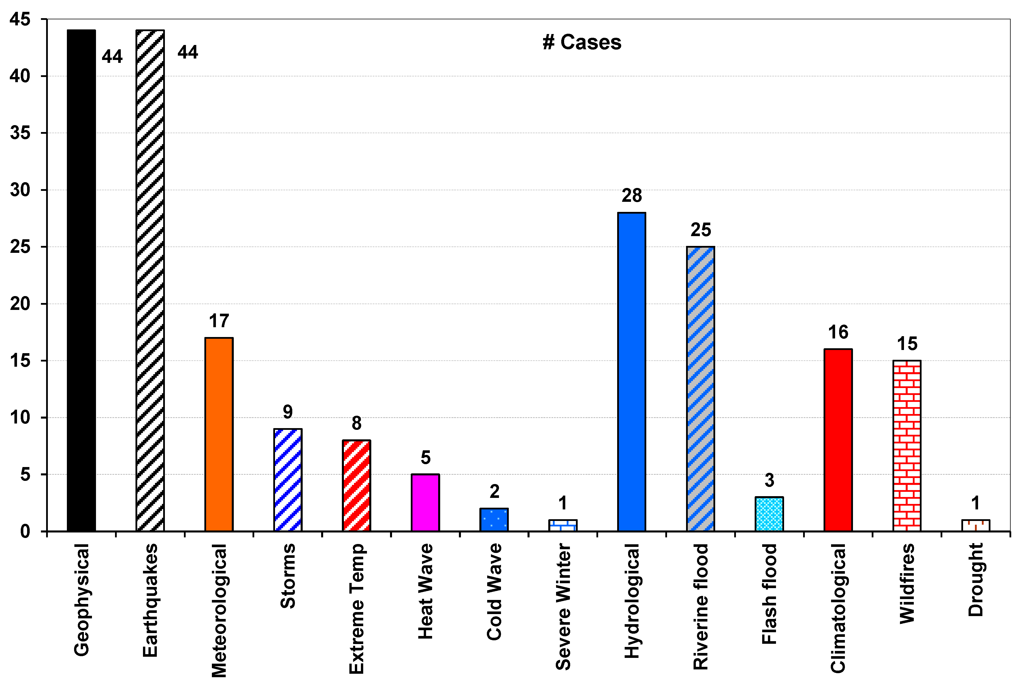
3. Results and Discussion

According to the EM-DAT database, 146 disasters were recorded in Greece from 1904 to 2020; 100 and 46 events were classified, respectively, as natural and technological disasters [1,5]. The period 1980–2021 records a total of 83 out of 100 natural disasters. The results obtained from the analysis of the database show a significant increase in disasters per year after 1980. The categories of natural disasters included in the database do not vary, but there has been a striking increase in the number of meteorological, hydrological, and climatic ones during the period 1980–2021.
Geophysical disasters, and especially earthquakes as a sole subcategory, have been the most significant category of all natural disasters in Greece. In the EM-DAT database, there are no geophysical hazard subcategories other than earthquakes (a total of 44, out of which 26 were registered after 1980). However, the case is not the same concerning the other main disaster classifications (Figure 1). Specifically, meteorological disasters (a total of 17, out of which 15 were registered after 1980), hydrological disasters (23, all of them registered after 1980), and climatic disasters (16, all of them registered after 1980). Meteorological disasters contain the subcategories “Storms” (9 cases) and “Extreme Temperatures” (8 cases), with the latter containing the sub-subcategories “Heat” (5), “Cold Waves” (2), and “Extreme Winter” (1 case). Hydrological disasters contain the subcategories “River Floods” (20 cases) and “Flash Floods” (3 cases). Finally, climatic disasters contain the subcategories “Extreme Fires” (15 cases) and “Drought” (1 case). The percentages of each category for human and property losses are the following: fatalities: both geophysical and meteorological disasters account for 29%, hydrological ones for 3%, and climatological disasters for 5%; injuries: 85.7%, 3.4%, 0.3%, and 7.7% respectively; number of homeless persons registered: 96.2%, 0.0%, 0.0%, and 2.1% respectively; the number of total affected population: 96.2%, 0.1%, 1.8%, and 1.6% by natural disaster category; with the total cost of disasters in USD 000’s adjusted value: 63.9%, 5.3%, 8.7%, and 21.9%, respectively.
The results for 20 events (17 meteorological) and 3 hydrological (flash floods) are shown in Figure 2. The results of the cases described above suggest that air mass transportation originated mainly from the Central and West Mediterranean regions in cases of storms and flash floods. Air masses usually circulate above the central Mediterranean Sea and Greece. Two major types of circulation were identified (cyclonic and anti-cyclonic), with variations concerning the strengths of each observed system. Air masses above the Mediterranean Sea usually enrich the air with humidity. Thus, for all the cases after 2002 where data became available, the sea surface temperature anomaly was checked. In all cases, it is positive, but it differs in terms of intensity and area extent [6].

4. Conclusions

Meteorological and hydrological disasters are associated with air masses circulation on a large scale, which favors the occurrence of such phenomena. In order to identify their characteristics, back-trajectories analysis was used. The results indicate that flash floods occur when air masses are moving above warm sea waters, while for the other meteorological disasters, air masses moved from South and West to North directions, indicating North Africa or North Europe/Atlantic areas [7].
In Greece, the main category of natural disasters are geophysical ones, especially earthquakes, which contribute significantly to the registered numbers of deaths and injuries [5]. Up until now, the efforts of precautionary measures and actions to reduce the effects of natural hazards have been focused on this category.
The disasters during the last decades show the need for action and protection measures for the other categories as well [8]. According to the data in the EM-DAT database, however, one fact emerged: the existence of non-registered disasters, which, according to the existing framework, only the General Secretariat of Civil Protection has the right to register. It is absolutely clear and understandable that every meteorological or other phenomenon is not a natural disaster (e.g., an earthquake that occurs at sea, far from populated areas). An example from Greece is the absence of registrations regarding biological disasters, despite the fact that at least in the last decades there have been epidemics of influenza (H1N1), West Nile Virus [9], the ongoing COVID-19 pandemic, etc. But the more complete the database, the better the results of its investigation.
Natural disasters usually cause a series of long-term damaging problems (human casualties, health, infrastructure, environmental, planning, etc.) that need long-term monitoring. It is important to record and register in international databases all the available data on natural disasters in Greece. The lack of data due to unrecorded disasters as well as incomplete international databases affects policy decision-making issues.
The empirical results of this study indicate that policymakers have to consider additional prevention and mitigation plans to meet new approaches regarding existing risks for the general population [10]. This could also be a planning and risk management tool for policy and decision-making authorities to chart their long-term future actions with a better understanding of potentially unfolding scenarios and their impacts.

Author Contributions

Conceptualization, E.P., D.E.A. and A.M.; methodology, A.M.; software, A.M.; validation, E.P. and A.M.; formal analysis, A.M.; investigation, A.M.; resources, E.P. and D.E.A.; data curation, A.M.; writing—original draft preparation, A.M.; writing—review and editing, E.P. and A.M.; visualization, A.M.; supervision, E.P. and D.E.A.; project administration, D.E.A.; funding acquisition. All authors have read and agreed to the published version of the manuscript.

Funding

The publication/registration fees were totally covered by the University of West Attica (P.N. 62570/30-06-2023).

Institutional Review Board Statement

Not applicable.

Informed Consent Statement

Not applicable.

Data Availability Statement

All data are openly available online from EM-DAT (www.emdat.be).

Acknowledgments

ARL NOAA and NILU are acknowledged for providing the HYSPLIT and FLEXTRA trajectories models used in this study.

Conflicts of Interest

The authors declare no conflict of interest.

References

  1. The Emergency Events Database (EM-DAT). Université Catholique de Louvain (U C Louvain)—CRED, D. Guha-Sapir, Brussels, Belgium. 2021. Available online: www.emdat.be (accessed on 20 April 2023).
  2. Air Resources Laboratory’s (ARL)—READY (Real-Time Environmental Applications and Display sYstem). Available online: https://www.ready.noaa.gov/hypub-bin/trajasrc.pl (accessed on 20 April 2023).
  3. Rolph, G.; Stein, A.; Stunder, B. Real-time Environmental Applications and Display sYstem: READY. Environ. Model. Softw. 2017, 95, 210–228. [Google Scholar] [CrossRef]
  4. Stohl, A. Computation, accuracy and applications of trajectories – a review and bibliography. Atmos. Environ. 1998, 32, 947–966. [Google Scholar] [CrossRef]
  5. Botsolis, F. Natural Disasters and Environmental Education. Master’s Thesis, University of Aegean, Rhodes, Greece, 2022. Available online: http://hdl.handle.net/11610/24151 (accessed on 20 April 2023).
  6. Patlakas, P.; Chaniotis, I.; Hatzaki, M.; Kouroutzoglou, J.; Flocas, H.A. The eastern Mediterranean extreme snowfall of January 2022: Synoptic analysis and impact of sea-surface temperature. Weather, 2023; Epub ahead of printing. [Google Scholar] [CrossRef]
  7. Mavrakis, A.; Kapsali, A.; Tsiros, I.X.; Pantavou, K. Air quality and meteorological patterns of an early spring heatwave event in an industrialized area of Attica, Greece. Euro-Mediterr. J. Environ. Integr. 2021, 6, 25. [Google Scholar] [CrossRef] [PubMed]
  8. Palmos, D.; Papavasileiou, C.; Papakitsos, C.E.; Vamvakeros, X.; Mavrakis, A. Enhancing the environmental programmes of secondary education by using web-tools concerning precaution measures in civil protection: The case of Western Attica (Greece). Saf. Sci. 2021, 135, 105117. [Google Scholar] [CrossRef]
  9. Mavrakis, A.; Papavasileiou, C.; Alexakis, D.; Papakitsos, C.E.; Salvati, L. Meteorological patterns and the evolution of West Nile virus in an environmentally stressed Mediterranean area. Environ. Monit. Assess. 2021, 193, 227. [Google Scholar] [CrossRef] [PubMed]
  10. Mavrakis, A.; Lykoudis, S.; Salvati, L. Predicting the Occurrence of Natural and Technological Disasters in Greece through Verhulst, Multinomial and Exponential Models. Saf. Sci. 2023, 166, 106246. [Google Scholar] [CrossRef]
Figure 1. Categories and sub-categories of registered geophysical, meteorological, hydrological, and climatological disasters in EM-DAT for Greece; number (#) of cases denoted per category.
Environsciproc 26 00095 g001
Figure 2. Air mass back trajectories as derived from HYSPLIT (ad) and FLEXTRA (e,f) web-based models (the colored lines denote the corresponding altitude): (a) The storm of 6 November 1961; (b) the snow of 7 March 1987; (c) the heat wave of July 1987 (24 July 1987); (d) the heat wave of July 1988 (03 July 1988); (e) the Mandra’ flash flood of 15 November 2017; (f) The flash flood of 10 July 2019.
Environsciproc 26 00095 g002
Table 1. Part of the EM-DAT records regarding 17 meteorological and 3 hydrological (flash flood) disasters.
Disaster TypeDisaster SubtypeDateTotal DeathsNo. of InjuredBack-TrajectoriesSST
Anomaly
StormConvective storm13 June 193022 N/AN/A
StormTropical cyclone6 November 196143 W-SWN/A
Extreme
temperature
Heat wave5 August 198520 NWN/A
Storm 9 March 198748 W-SWN/A
Extreme
temperature
Heat wave20 July 19871000 W-NWN/A
Extreme
temperature
Heat wave3 July 198856 WN/A
Storm 28 February 19903 W-SWN/A
Extreme
temperature
Cold wave5 February 19915 NN/A
Extreme
temperature
Heat wave1 July 200027176NWN/A
Storm 4 January 2002212W-SW+
Storm 22 January 2004 W-SW+
Storm 13 February 2004 W-SW+
Storm 17 October 20063 W-SW+
Extreme
temperature
Heat wave1 June 200716 NW+
Extreme
temperature
Cold wave1 February 20125 N+
Extreme
temperature
Severe winter conditions20 January 2017 NW-N-NE+
StormConvective storm10 July 20197123S-SW+
Flash floodDepression ‘Gonzalo’24 October 2014 S-SW+
Flash floodSlide (land, mud, snow, rock)15 November 20172324S-SW+
Flash flood 11 November 2020 W-SW+
Disclaimer/Publisher’s Note: The statements, opinions and data contained in all publications are solely those of the individual author(s) and contributor(s) and not of MDPI and/or the editor(s). MDPI and/or the editor(s) disclaim responsibility for any injury to people or property resulting from any ideas, methods, instructions or products referred to in the content.

