Proceeding Paper

Multi-Decadal Monitoring of Soil Erosion Rates in South Europe †

by
Stefanos Stefanidis
1,*,
Giorgos Mallinis
2 and
Vasileios Alexandridis
2
1
Laboratory of Mountainous Water Management and Control, School of Forestry and Natural Environment, Aristotle University of Thessaloniki, 54124 Thessaloniki, Greece
2
Laboratory of Photogrammetry and Remote Sensing (PERS Lab), School of Rural and Surveying Engineering, Aristotle University of Thessaloniki, 54124 Thessaloniki, Greece
*
Author to whom correspondence should be addressed.
Presented at the 16th International Conference on Meteorology, Climatology and Atmospheric Physics—COMECAP 2023, Athens, Greece, 25–29 September 2023.
Environ. Sci. Proc. 2023, 26(1), 138; https://doi.org/10.3390/environsciproc2023026138
Published: 31 August 2023

Abstract

:
Soil loss by water is a major form of land degradation with environmental and economic consequences. In particular, erosion rates are sensitive to both climate and land cover changes. The present study investigates the temporal changes in soil loss rate over South Europe during the 1980–2018 period. To that end, the Revised Universal Soil Loss Equation (RUSLE) was applied by integrating information from freely available geospatial datasets to conduct a multi-decadal assessment. In this frame, the temporal variability of the two dynamic RUSLE factors, namely rainfall erosivity (R) and cover management (C), was explored. Specifically, the rainfall erosivity values per decade were acquired from a newly developed dataset from the European Soil Data Center (ESDAC), coupling the Rainfall Erosivity Database at European Scale (REDES) and UERRA regional reanalysis rainfall data. On the other hand, land cover data were retrieved from the CORINE dataset (CLC) through the Copernicus Land Monitoring Service for different reference years. The appropriate values were assigned to each CLC category per country according to the recent literature to determine the C-factor. In terms of the other three static RUSLE factors, namely soil erodibility (K), slope length and steepness (LS) and support practice (P), these were obtained from the ESDAC database by exploiting the results of previous pan-European assessments. The results indicate that the mean annual soil erosion rates in South Europe were 6.82, 4.90, 4.89 and 5.26 t/ha/year for the decades 1981–1990, 1991–2000, 2001–2010 and 2011–2018, respectively.

1. Introduction

Soil is considered a non-renewable resource, meaning its loss and degradation is not recoverable within a human lifespan. During recent decades, it has been threatened by accelerating water-induced erosion with negative impacts on land productivity, ecosystem sustainability and the landscape. Therefore, the problem of soil erosion has become part of the environmental agenda in the European Union (EU) [1]. The European Commission’s Soil Thematic Strategy (COM, 2006) has recognized the need for its protection and called for quantitative assessments of soil loss rates at the European level [2], while the United Nations (UN) Sustainable Development Goals (SDGs) acknowledge the significance of soil resources for sustainable development and advocate their protection to meet the ambitious goal of zero land degradation by 2030 [3]. In addition, the EU Soil Strategy for 2030, published recently, updated the 2006 EU Soil Thematic Plan and attempted to address land degradation comprehensively, highlighting the need for protection against erosion [4].
Particularly in Mediterranean countries, the climate regime, complex topography, and human activities favor the development of accelerated erosion [5]. Quantitative spatiotemporal monitoring of soil erosion and soil loss rates is a necessity for policymaking. In the last few years, the ever-growing availability of high-resolution Earth Observation (EO) data and the well-established use of geospatial technologies have made the large-scale estimation of soil loss rates feasible through erosion modeling approaches. Compared to field measurements, erosion prediction models require less financial and human resources. Furthermore, field plots cannot fully cover large areas but are limited to specified sites, whereas measurements are meted out for a brief period [6]. Thus, there are limitations in extrapolating results to larger scales and areas with different conditions. In this context, the Plenary Assembly of the Global Soil Partnership (GSP) supports that the new UN global soil erosion map will be based on modeling, unlike prior evaluations that were based on expert opinions.
Empirical models with simple structures and low data requirements can facilitate quantitative monitoring of soil loss rates in a broad geographic region [7]. The Universal Soil Loss Equation (USLE) [8] and its revised (R) version RUSLE [9] are the most widely used empirical models. The minimal number of factors included in the USLE/RUSLE model, combined with advances in the availability of data extracted from EO sensors and the extensive literature documentation, facilitates the spatially explicit quantification of parameters, making this model particularly appealing for the dynamic monitoring of soil loss rates at various spatiotemporal scales. The present study investigates the temporal changes in soil loss rate over South Europe during the 1980–2018 period using the RUSLE model and open-access geospatial data.

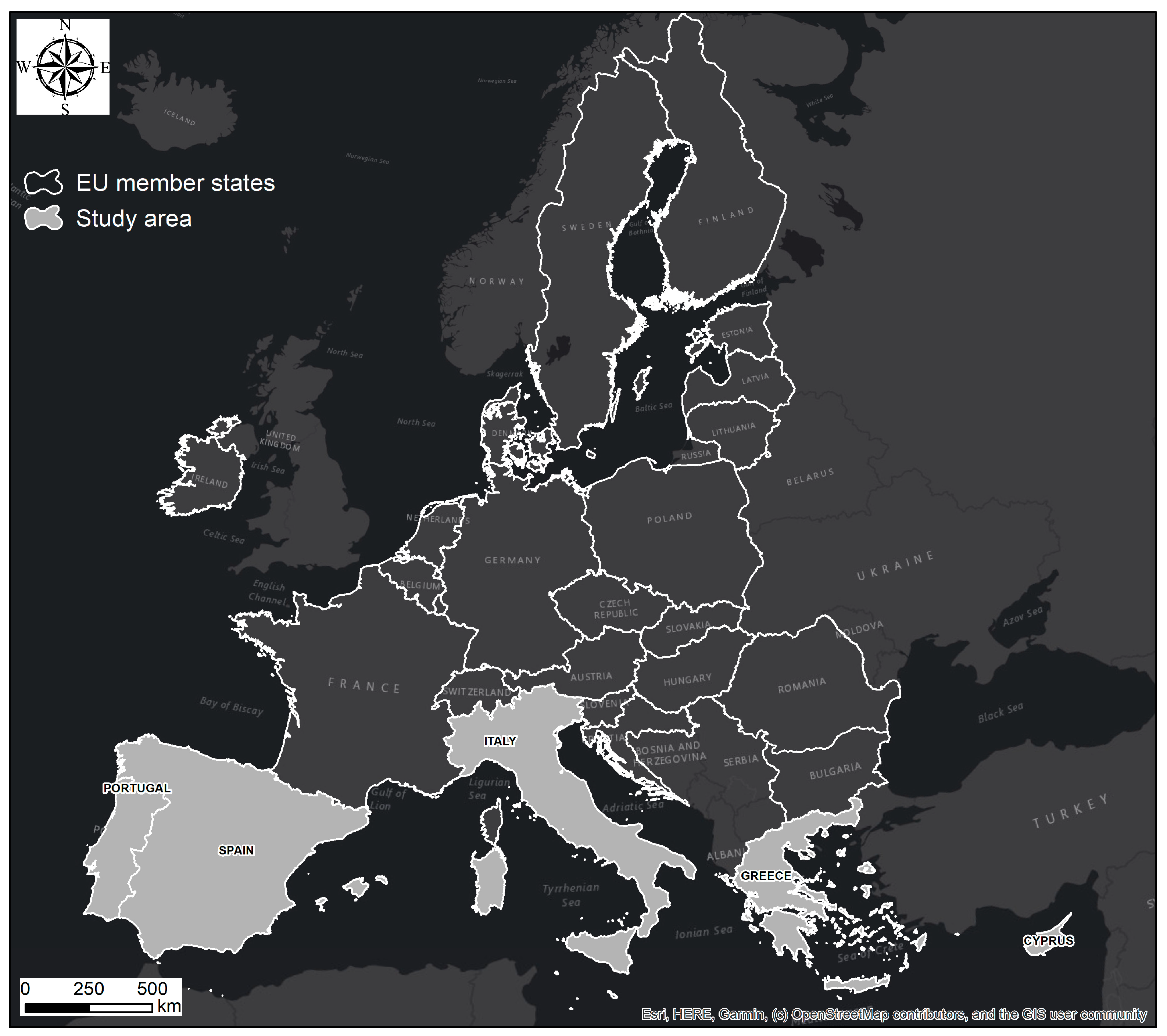
2. Material and Methods

The study was conducted in EU member states located in Southern Europe. Specifically, temporal changes (1980–2018) in soil erosion rate were assessed for the following countries: Cyprus (CY), Greece (EL), Spain (ES), Italy (IT) and Portugal (PT) (Figure 1).
Multi-decadal assessment of soil erosion rates in southern European countries during the entire 1980–2018 period and four distinct sub-periods (i.e., 1981–1990, 1991–2000, 2001–2010 and 2011–2018) was accomplished using the RUSLE model. The mathematical description of the model is expressed as a linear combination of five factors [9]:
A = R × K × LS × C × P
where A is the computed soil loss rate (t ha−1 y−1), R is the rainfall erosivity factor (MJ mm ha h−1 y−1), K is the soil erodibility factor (t ha h ha−1 MJ−1 mm−1), LS is the combined effect of slope length (L) and slope steepness factor (S) (dimensionless), C is the cover management factor (dimensionless) and P is the conservation practice factor (dimensionless). The model output pixel size was set to 100 m and the coordinate system was the standard European Coordinate Reference System defined by the European Terrestrial Reference System 1989 (ETRS89) datum and Lambert Azimuthal Equal Area (LAEA) projection (EPSG: 3035).
The rainfall erosivity factor (R) is the model’s climate component, accounting for the ability of rainfall to cause erosion, considering the amount, intensity and duration of rainfall. The soil erodibility factor (K) describes the susceptibility of a particular soil type to erosion based on its texture, structure, organic matter content and permeability. The combination of slope length (L) and slope steepness (S) describes the effect of topography on the erosion process. The L factor is based on the length of the slope over which water flows, while the S factor is based on the angle of the slope. The cover management factor (C) describes the effect of vegetation cover and crop management practices on erosion, while the support practice factor (P) describes the effect of conservation practices such as contour farming, stone walls, terracing and grass margins on erosion mitigation.
In order to accomplish the goals of the current research, spatial datasets from open-access databases were collected and processed. The K, LS, P and R factors were obtained in raster format from the European Soil Data Center (ESDAC), while the C factor was based on the CORINE dataset (CLC) through the Copernicus Land Monitoring Service. The literature provides a detailed description of the methodologies used to estimate the aforementioned factors. In particular, the K-factor was estimated using measured soil data collected during the 2009 LUCAS soil survey campaign across European Union member states, along with the nomograph of Wischmeier and Smith [8] as described by Panagos [10]. The high-resolution EU-DEM was utilized as input to the algorithm developed by Desmet and Govers [11] to estimate the LS factor [12], whereas the P-factor takes into account the Good Agricultural and Environmental Condition (GAEC) measures applied in the EU Member States and the ground observations both on land use/cover and landscape features (LUCAS) [13]. Regarding the R factor, a newly created dataset was exploited, coupling the Rainfall Erosivity Database at European Scale (REDES) and UERRA regional reanalysis rainfall data [14] for the decades 1981–1990, 1991–2000, 2001–2010 and 2011–2018. Finally, appropriate values were assigned to each CLC category per country according to the recent literature in order to determine the C-factor [15]. Herein, the products of CLC 1990, CLC 2000, CLC 2006 and CLC 2018 were utilized.
By using the ArcGIS (v10.2) software package, all the above datasets were organized in GIS thematic layers. A brief description of their source, spatial resolution and primary format is presented in the following table (Table 1).

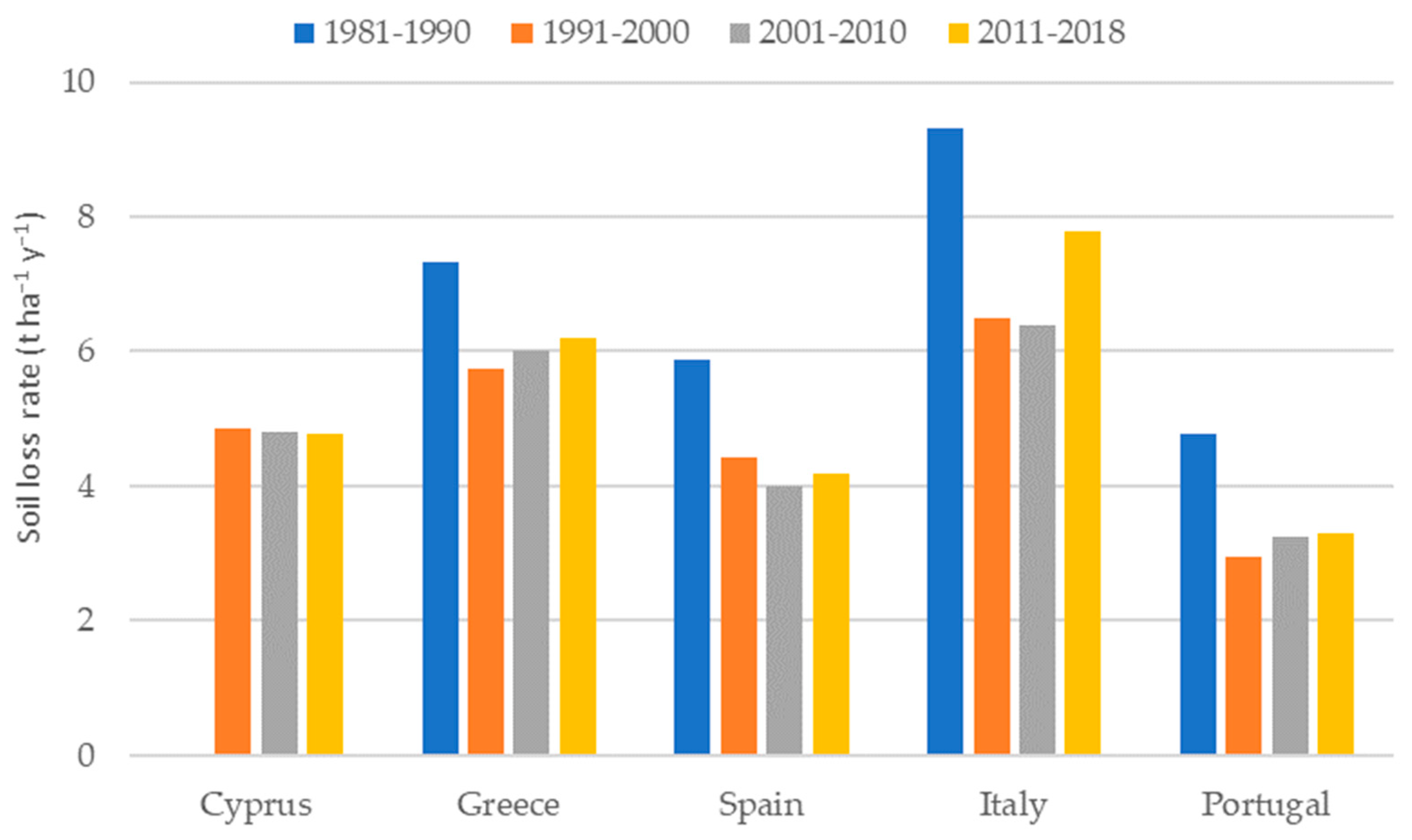
3. Results and Discussion

Figure 2 presents the soil loss rates in southern Mediterranean countries over the last four decades. The findings revealed that soil loss rates in southern EU nations are higher than the European average (2.46 t ha−1 y−1) [16] and significantly higher than the average rate of soil formation in Europe of 1.4 t ha−1 y−1 [17]. Generally, the highest mean annual soil loss rate is found in Italy, followed by Greece and Cyprus. Additionally, changes are observed in the rates of soil loss during the examined period due to the variability of dynamic RUSLE factors.
The temporal variability of the R- and C-factors is illustrated in Figure 3. An average decrease of approximately 30% is reported in the C-factor values from 1990 to 2000, while it is almost stable over the other periods. On the other hand, the R-factor has slightly changed at the country level over the last four decades.
Between the periods 1981–1990 and 1991–2000, decreases in the mean annual soil loss rate were reported in the southern EU countries. The largest decrease was found in Portugal (38.3%), followed by Italy (30.2%), while considerable decreases of about 30% were found in Greece and Spain. On the contrary, a slight increase was found when comparing the erosion rate between 2001–2010 and 2011–2018, with the highest proportion found in Italy (21.9%), followed by Spain (4.8%) and Greece (3.4%).

4. Conclusions

This study provides a comprehensive analysis of the temporal variability of soil loss rates in southern EU countries over the last four decades. The study area faces accelerated erosion problems due to the combination of high rainfall erosivity, relatively steep slopes and human pressure on the landscape characteristics. Our approach integrates freely available geospatial datasets and the RUSLE erosion prediction model. The observed changes in the rates of soil loss are attributed to the variability of dynamic RUSLE factors, namely cover management (C) and rainfall erosivity (R). The C-factor was determined using CORINE land cover (CLC) datasets derived from satellite image processing for different reference periods. In terms of the R-factor, it was obtained from a newly released ESDAC dataset that combines rainfall measurements from stations included in the REDES database with UERRA reanalysis rainfall data.
The applied methodology is highly transferable and easily applied for large-scale assessments of soil loss rates, as it is based on open-access geospatial data and a simple empirical model. The outputs are useful for authority bodies and policymakers in order to establish a pan-European erosion mitigation strategy. An extension of the present research could be the spatiotemporal assessment of soil conservation ecosystem services in Europe.

Author Contributions

Conceptualization, S.S. and G.M.; methodology, S.S. and V.A.; software, S.S. and V.A.; formal analysis, S.S.; investigation, S.S.; writing—original draft preparation, S.S. and V.A.; writing—review and editing, S.S., G.M. and V.A.; visualization, S.S.; supervision, G.M. All authors have read and agreed to the published version of the manuscript.

Funding

This research received no external funding.

Data Availability Statement

The data that support the findings of this study are available from the corresponding author upon reasonable request.

Conflicts of Interest

The authors declare no conflict of interest.

References

  1. Robinson, N. The European union’s environmental agenda. Environ. Politics 1999, 8, 188–192. [Google Scholar] [CrossRef]
  2. EC. Proposal for a Establishing a Framework for the Protection of Soil and Amending. Directive 2004/35/EC COM, 232. 2006. Available online: https://eur-lex.europa.eu/legal-content/en/ALL/?uri=CELEX%3A52006PC0232 (accessed on 28 March 2023).
  3. Keesstra, S.D.; Bouma, J.; Wallinga, J.; Tittonell, P.; Smith, P.; Cerdà, A.; Montanarella, L.; Quinton, J.N.; Pachepsky, Y.; van der Putten, W.H. The significance of soils and soil science towards realization of the United Nations Sustainable Development Goals. Soil 2016, 2, 111–128. [Google Scholar] [CrossRef]
  4. Panagos, P.; Montanarella, L. Soil Thematic Strategy: An important contribution to policy support, research, data development and raising the awareness. Curr. Opin. Environ. Sci. Health 2018, 5, 38–41. [Google Scholar] [CrossRef]
  5. García-Ruiz, J.M.; Nadal-Romero, E.; Lana-Renault, N.; Beguería, S. Erosion in Mediterranean landscapes: Changes and future challenges. Geomorphology 2013, 198, 20–36. [Google Scholar] [CrossRef]
  6. Vanmaercke, M.; Poesen, J.; Radoane, M.; Govers, G.; Ocakoglu, F.; Arabkhedri, M. How long should we measure? An exploration of factors controlling the inter-annual variation of catchment sediment yield. J. Soils Sediments 2012, 12, 603–619. [Google Scholar] [CrossRef]
  7. Batista, P.; Laceby, J.; Davies, J.; Carvalho, T.; Tassinari, D.; Silva, M.; Curi, N.; Quinton, J. A framework for testing large-scale distributed soil erosion and sediment delivery models: Dealing with uncertainty in models and the observational data. Environ. Model. Softw. 2021, 137, 104961. [Google Scholar] [CrossRef]
  8. Wischmeier, W.H.; Smith, D.D. Predicting Rainfall Erosion Losses, a Guide to Conservation Planning; U.S. Department of Agriculture: Washington, DC, USA, 1978; Volume 537, p. 62. [Google Scholar]
  9. Renard, K.G.; Foster, G.R.; Weesies, G.A.; Porter, J.P. RUSLE: Revised universal soil loss equation. J. Soil Water Conserv. 1991, 46, 30–33. [Google Scholar]
  10. Panagos, P.; Meusburger, K.; Alewell, C.; Montanarella, L. Soil erodibility estimation using LUCAS point survey data of Europe. Environ. Model. Softw. 2012, 30, 143–145. [Google Scholar] [CrossRef]
  11. Desmet, P.; Govers, G. A GIS procedure for automatically calculating the ULSE LS factor on topographically complex landscape units. J. Soil Water Conserv. 1996, 51, 427–433. [Google Scholar]
  12. Panagos, P.; Borrelli, P.; Meusburger, K. A new European slope length and steepness factor (LS-Factor) for modeling soil erosion by water. Geosciences 2015, 5, 117–126. [Google Scholar] [CrossRef]
  13. Panagos, P.; Borrelli, P.; Meusburger, K.; Van Der Zanden, E.H.; Poesen, J.; Alewell, C. Modelling the effect of support practices (P-factor) on the reduction of soil erosion by water at European scale. Environ. Sci. Policy 2015, 51, 23–34. [Google Scholar] [CrossRef]
  14. Bezak, N.; Ballabio, C.; Mikoš, M.; Petan, S.; Borrelli, P.; Panagos, P. Reconstruction of past rainfall erosivity and trend detection based on the REDES database and reanalysis rainfall. J. Hydrol. 2020, 590, 125372. [Google Scholar] [CrossRef]
  15. Panagos, P.; Borrelli, P.; Meusburger, K.; Alewell, C.; Lugato, E.; Montanarella, L. Estimating the soil erosion cover-management factor at the European scale. Land Use Policy 2015, 48, 38–50. [Google Scholar] [CrossRef]
  16. Panagos, P.; Borrelli, P.; Poesen, J.; Ballabio, C.; Lugato, E.; Meusburger, K.; Montanarella, L.; Alewell, C. The new assessment of soil loss by water erosion in Europe. Environ. Sci. Policy 2015, 54, 438–447. [Google Scholar] [CrossRef]
  17. Verheijen, F.G.; Jones, R.J.; Rickson, R.J.; Smith, C.J. Tolerable versus actual soil erosion rates in Europe. Earth-Sci. Rev. 2009, 94, 23–38. [Google Scholar] [CrossRef]
Figure 1. Location and extent of the study area.
Environsciproc 26 00138 g001
Figure 2. The soil loss rate in southern EU countries per decade.
Environsciproc 26 00138 g002
Figure 3. Temporal variability of (a) R-factor and (b) C-factor over the examined period.
Environsciproc 26 00138 g003
Table 1. Summary of spatial datasets used in this study.
DatasetData SourceData AccessibilitySpatial
Resolution
Format
Soil Erodibility
(K-factor)
European Soil Data Center (ESDAC)https://esdac.jrc.ec.europa.eu/content/soil-erodibility-k-factor-high-resolution-dataset-europe (accessed on 15 April 2023)500 mraster
Slope Length and Steepness
(LS-factor)
European Soil Data Center (ESDAC)https://esdac.jrc.ec.europa.eu/content/ls-factor-slope-length-and-steepness-factor-eu (accessed on 15 April 2023)25 mraster
Support Practices
(P-factor)
European Soil Data Center (ESDAC)https://esdac.jrc.ec.europa.eu/content/support-practices-factor-p-factor-eu (accessed on 15 April 2023)1 kmraster
Rainfall erosivity
(R-factor)
European Soil Data Center (ESDAC)https://esdac.jrc.ec.europa.eu/content/rainfall-erosivity-european-union-and-switzerland (accessed on 15 April 2023) 1 kmraster
Cover Management
(C-factor)
Copernicus Land Monitoring Servicehttps://land.copernicus.eu/pan-european/corine-land-cover (accessed on 15 April 2023)-vector
Disclaimer/Publisher’s Note: The statements, opinions and data contained in all publications are solely those of the individual author(s) and contributor(s) and not of MDPI and/or the editor(s). MDPI and/or the editor(s) disclaim responsibility for any injury to people or property resulting from any ideas, methods, instructions or products referred to in the content.

