Proceeding Paper

Lightning-Caused Wildfires: The Case of Mount Mainalo, Arcadia, Greece †

by
Miltiadis Athanasiou
1,*,
Panagiotis Nastos
2,
Ioannis Kouretas
2 and
Athanasios Karadimitris
2
1
Wildfire Management Consulting and Training, 13673 Athens, Greece
2
Laboratory of Climatology and Atmospheric Environment, Department of Geology and Geoenvironment, National and Kapodistrian University of Athens, University Campus, 15784 Athens, Greece
*
Author to whom correspondence should be addressed.
Presented at the 16th International Conference on Meteorology, Climatology and Atmospheric Physics—COMECAP 2023, Athens, Greece, 25–29 September 2023.
Environ. Sci. Proc. 2023, 26(1), 114; https://doi.org/10.3390/environsciproc2023026114
Published: 29 August 2023

Abstract

:
This paper concerns eighty (80) lightning-ignited wildfires on Mount Mainalo, Greece, during the period from 1998 to 2022. Descriptive statistics of the dataset, frequency distribution histograms, and maps were used to describe the number of fires per year, the burned area per fire, the total burned area per year, the elevation of lightning-caused fire occurrences, the wildfire detection time, and the holdover time (the phase between the ignition and fire detection). The analysis shows an increased frequency of lightning-caused wildfires in August and July. Most of the fires took place in the southern part of the mountain and were detected in the afternoon hours. These preliminary findings and conclusions provide a comprehensive understanding of the past regime of natural fire on Mount Mainalo, and they can support improving wildfire prevention and management policies in the region.

1. Introduction

Wildfires in mountain coniferous forests are usually caused by cloud-to-ground lightning (CGL) produced by dry summer thunderstorms [1] which usually take place in the afternoon hours in areas with low atmospheric humidity. CGL occurrence increases ignition probability, thus increasing fire danger or risk. Fire-igniting lightning tends to occur under weak updrafts but at the time and position of high cloud tops [2]. Natural electrical discharges may occur within the same cloud (intra-cloud lightning) or between clouds (cloud-to-cloud lightning) as well, not reaching the ground, and it is often not known how many CGL strikes cause vegetation ignition. Lightning strikes either standing trees (live or dead) or fallen tree trunks, causing the smoldering of dead organic matter around the base of the tree [3] or the fallen tree trunk and after a while, an open flame appears. The time interval between the lightning and the ignition varies considerably. In some cases, the lightning and the ignition are almost concurrent, and they are also immediately detected, but there is usually a time interval between the moment of ignition and the moment of fire detection, which is called “holdover time” [4,5]. Atmospheric instability and thunderstorms shape local meteorological conditions over mountainous areas in Greece during summer, usually accompanied by thousands of lightning bolts, strong or gale-force winds, hail, and occasionally rain. Analyses of the spatial variability of lightning have shown that in central Peloponnese, the relative flash density is very high [6].
A database including data from the Forest Directorate of Arcadia, the Fire Service of Megalopolis, Peloponnese, reliable records from fire lookouts, forest firefighters, and residents was initially created in 2021 [7]. It was further enriched, and it now consists of 80 cases of lightning-caused fires on Mount Mainalo, for the period from 1998 to 2022. The scope of this study is to draw conclusions regarding the spatial and temporal variability and distribution of lightning-caused wildfires, the burned area per fire, the total burned area per year, the elevation of lightning-caused fire occurrences, the wildfire detection time, and the holdover time. Hence, no wildfire behavior data have been matched with the above-mentioned fields of the database, up to now. These preliminary findings and conclusions are to provide fire managers with a comprehensive understanding of the past regime of natural fire on Mount Mainalo and they can support decision making, facilitate future scientific research, and potentially improve wildfire prevention and management in the region. Lightning is the only natural cause of wildfires in Greece, but little is known about natural fire regimes in the country. The development of a database from primary data sources adds to the existing knowledge, demonstrating the potential significance of the current research.

2. Materials and Methods
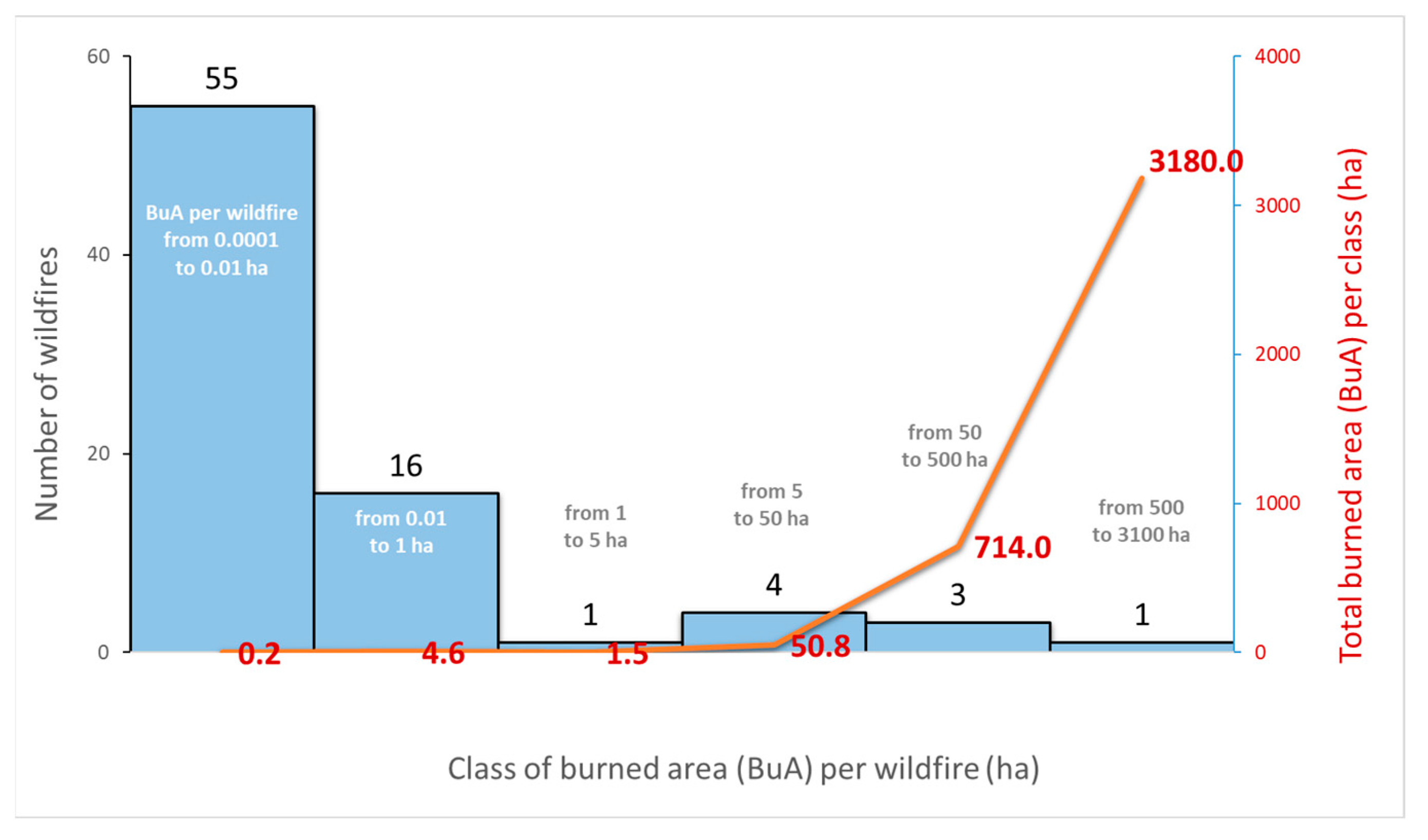
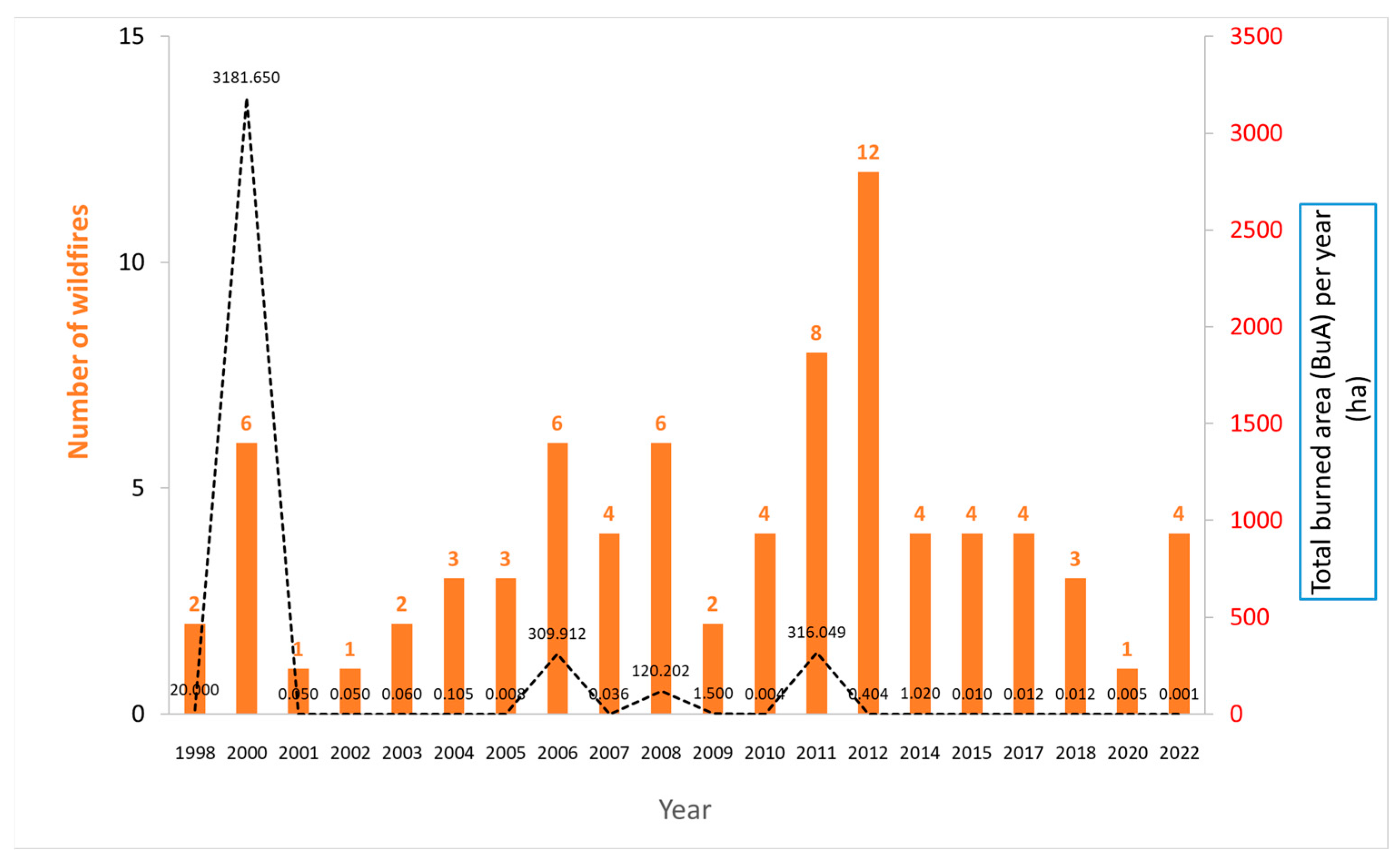
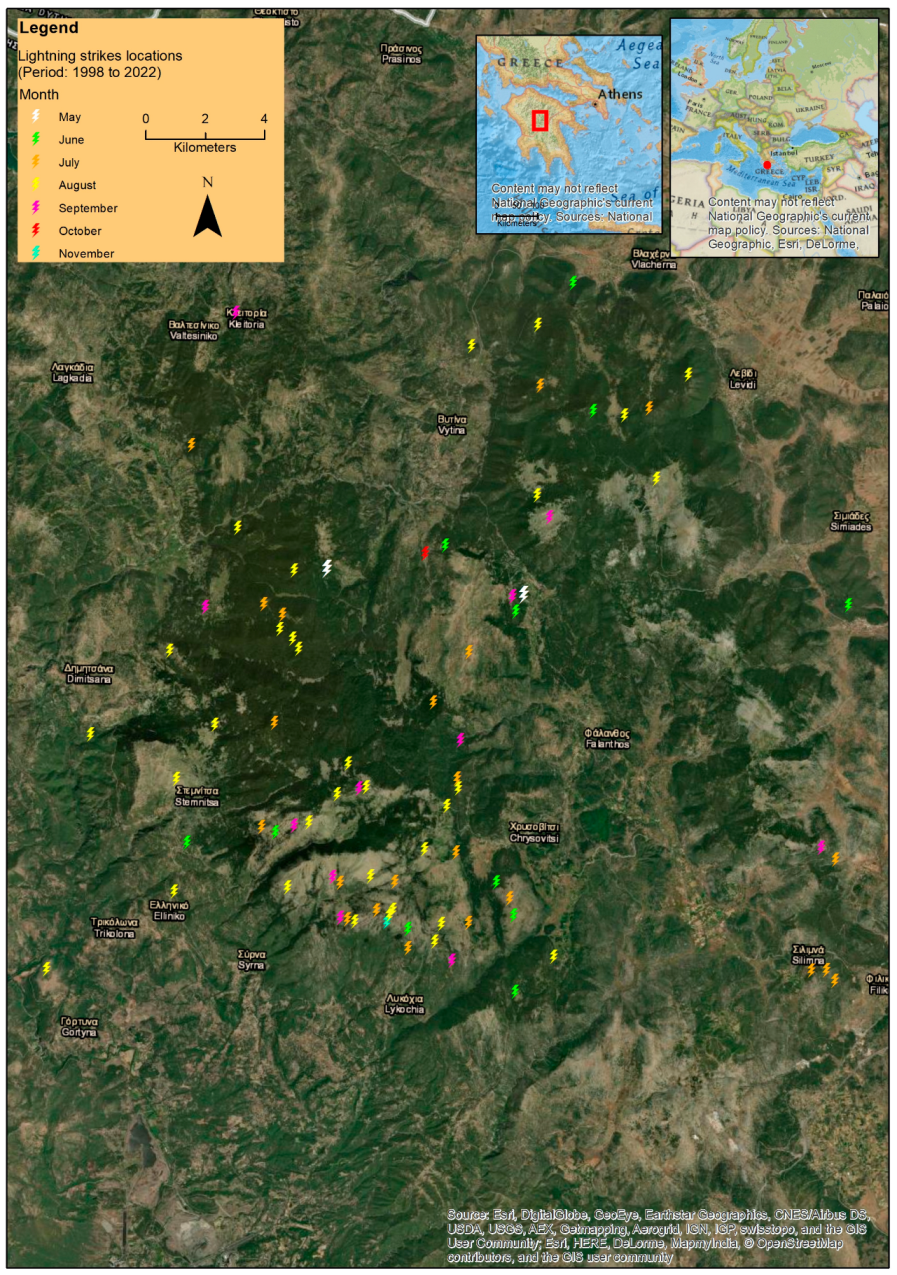
Data obtained by fire lookouts, forest officers, and local firefighters who had detected lightning bolts and had spotted the eruption sites were matched with wildfire detection and holdover times as well as with the burned areas. A database was developed consisting of eighty (80) lightning-ignited wildfires (N = 80) on Mount Mainalo, Greece, for the period from 1998 to 2022. It includes information about the (a) date of lightning, (b) geographic coordinates of the lightning locations (eruption sites) (in GGRS87), (c) altitude (elevation) of the lightning locations (Elv, m), (d) wildfire detection time (Fdt) known for 76 cases, (e) holdover time (Hldt, h) known for 48 cases, and (h) burned area (BuA, ha). Of a total BuA of 3951.1 ha of the 80 records (fires) in the database, 3894 ha concern only four records, namely the case with the largest BuA of 3180 ha by two merged fires (the first caused by lightning and the second by an unknown cause) and three more fires, the BuA of which was 120, 294, and 300 ha, respectively. The remaining BuA of 57.1 ha corresponds to the remaining 76 fires in the database, each one with a BuA not exceeding 15.9 ha. Those 76 fires are classified in the first four classes in Figure 1. Frequency distribution histograms and descriptive statistics of some subsets of the database were created to describe the number of fires per year, the burned area per fire, the total burned area per year, the elevation (Elv, m) of lightning-caused fire occurrences, the wildfire detection time (Fdt), and the holdover time (Hldt, h). The exact locations of the lightning strikes were pinpointed on the map using the ArcGIS 9.3 Geographic Information System (GIS) software by ESRI corporation.

3. Results

The 80 fires were classified into six (6) empirical classes based on the BuA per fire and the total BuA per class was calculated (Figure 1).
A histogram of the frequency distribution of the wildfires and the total BuA per year was also generated (Figure 2). In the years 1999, 2013, 2016, and 2019 there were no lightning-caused wildfires recorded.
The mean, standard error (S.E.), median, mode, standard deviation (S.D.), minimum (min) and maximum (max) of Fdt, Elv (m), BuA (ha), and Hldt (h) values for the subsets of known Fdt (N = 76) and known Hldt (N = 48) are reported in Table 1.
The lightning strike map that was generated represents the exact locations of the lightning strikes, visualizing the spatial distribution of the eruption sites of lightning-ignited wildfires on Mount Mainalo, Greece (Figure 3).

4. Discussion—Conclusions

The results of the research show that lightning-caused wildfires were most frequent in August and July; most of them erupted in the southern part (Figure 3) of Mount Mainalo and were detected in the afternoon hours (Table 1).
The featured spatial and temporal variability of lightning-caused wildfires with burned areas and holdover times (Figure 1, Figure 2 and Figure 3, Table 1) provides a comprehensive understanding of the past regime of natural fire on Mount Mainalo. These preliminary findings and conclusions can support decision making, facilitate future scientific research, and potentially improve wildfire prevention and management in the region, protecting the high-elevation coniferous forests [8,9].
For example, the finding that the mean and maximum altitudes at which lightning-caused wildfires occur are close to 1200 m and 1800 m, respectively (Table 1), can support a hands-on approach to day-to-day activities regarding ground patrol and lookout tower staffing. So can the finding that during the summer period, there is a positive relationship between lightning activity and elevation, slope, and woodland areas [10], and that lightning activity over continental mountainous regions is significantly high [11].
Future work, as data continue being collected and the database is expanded, is expected to shed additional light on the issues discussed in this paper, ultimately improving the early detection of lightning-caused wildfires in high-elevation coniferous forests in Greece.

Author Contributions

Conceptualization, M.A.; methodology, M.A.; formal analysis, M.A.; investigation, M.A., I.K., A.K.; resources, M.A., I.K., A.K.; data curation, M.A.; writing—original draft preparation, M.A.; writing—review and editing, M.A., P.N.; visualization, M.A.; supervision, M.A.; All authors have read and agreed to the published version of the manuscript.

Funding

This research received no external funding.

Institutional Review Board Statement

Not applicable.

Informed Consent Statement

Not applicable.

Data Availability Statement

Data is available upon request.

Acknowledgments

We would like to thank Fotios Papachatzis for providing useful insights into some of the cases included in the database.

Conflicts of Interest

The authors declare no conflict of interest.

References

  1. Reineking, B.; Weibel, P.; Conedera, M.; Bugmann, H. Environmental determinants of lightning- v. human-induced forest fire ignitions differ in a temperate mountain region of Switzerland. Int. J. Wildland Fire 2010, 19, 541–557. [Google Scholar] [CrossRef]
  2. Pérez-Invernón, F.J.; Huntrieser, H.; Soler, S.; Gordillo-Vázquez, F.J.; Pineda, N.; Navarro-González, J.; Reglero, V.; Montanyà, J.; van der Velde, O.; Koutsias, N. Lightning-ignited wildfires and long continuing current lightning in the Mediterranean Basin: Preferential meteorological conditions. Atmos. Chem. Phys. 2021, 21, 17529–17557. [Google Scholar] [CrossRef]
  3. Ogilvie, C.J. Lightning fires in Saskatchewan forests. Fire Manag. Notes 1989, 50, 31–32. [Google Scholar]
  4. Wotton, B.M.; Martell, D.L. A lightning fire occurrence model for Ontario. Can. J. For. Res. 2005, 35, 1389–1401. [Google Scholar] [CrossRef]
  5. Moris, J.V.; Conedera, M.; Nisi, L.; Bernardi, M.; Cesti, G.; Pezzatti, G.B. Lightning-caused fires in the Alps: Identifying the igniting strokes. Agric. For. Meteorol. 2020, 290, 107990. [Google Scholar] [CrossRef]
  6. Mazarakis, N.; Kotroni, V.; Lagouvardos, K.; Argiriou, A.A. Storms and Lightning Activity in Greece during the Warm Periods of 2003–06. J. Appl. Meteorol. Climatol. 2008, 47, 3089–3098. [Google Scholar] [CrossRef]
  7. Kouretas, I.; Athanasiou, M. Lightning-caused fires on Mount Mainalo: Analysis of identified igniting strokes. In Proceedings of the 20th Hellenic Forestry Conference, Trikala, Greece, 3–6 October 2021; pp. 102–110. [Google Scholar]
  8. Gkouvas, M. Drought, insects and wildfires threatening fir forests of Arcadia. In Mount of Arcadia; Club of Arcadian Mountaineers and Ecologists: Tripoli, Greece, 2011; Volume 25, pp. 30–31. [Google Scholar]
  9. Papageorgiou, S. Lightning-Caused Wildfires. 2015. Available online: https://www.fire.gr/?p=21226 (accessed on 25 May 2023).
  10. Kotroni, V.; Lagouvardos, K. Lightning occurrence in relation with elevation, terrain slope, and vegetation cover in the Mediterranean. J. Geophys. Res. 2008, 113, D21118. [Google Scholar] [CrossRef]
  11. Nastos, P.T.; Matsangouras, I.T.; Chronis, T.G. Spatio-temporal analysis of lightning activity over Greece—Preliminary results derived from the recent state precision lightning network. Atmos. Res. 2014, 144, 207–217. [Google Scholar] [CrossRef]
Figure 1. Frequency distribution of wildfires based on burned area (BuA) classes and the total burned area per class (N = 80).
Environsciproc 26 00114 g001
Figure 2. Frequency distribution of wildfires. The number of lightning-caused wildfires and the total BuA, per year (N = 80). These 80 fires occurred in the May to November period.
Environsciproc 26 00114 g002
Figure 3. Spatial and temporal (per month) distribution of lightning-caused wildfires on Mount Mainalo, Arcadia, Greece, for the period 1998 to 2022.
Environsciproc 26 00114 g003
Table 1. Descriptive statistics of Fdt, Elv, BuA, and Hldt. The first three (3) fields refer to the subset of known Fdt (N = 76). Fields from 4 to 7 refer to the subset of known Hldt (N = 48).
Fdt
(hh:mm)
Elv
(m)
BuA per fire (ha)Fdt
(hh:mm)
Elv
(m)
Hldt
(h)
BuA per fire (ha)
Mean15:5012439.915:32120520.8615.6
S.E.23 min275.729 min346.428.9
Median17:0912410.00516:0711951.740.003
Mode17:3013420.00517:30 0.170.0002
S.D.3 h 16 min23449.53 h 25 min23244.4562
min8:024200.00018:024200.10.0001
max21:30184230021:301842222.8300
Total 751.1 749
Ν76767648484848
Disclaimer/Publisher’s Note: The statements, opinions and data contained in all publications are solely those of the individual author(s) and contributor(s) and not of MDPI and/or the editor(s). MDPI and/or the editor(s) disclaim responsibility for any injury to people or property resulting from any ideas, methods, instructions or products referred to in the content.

