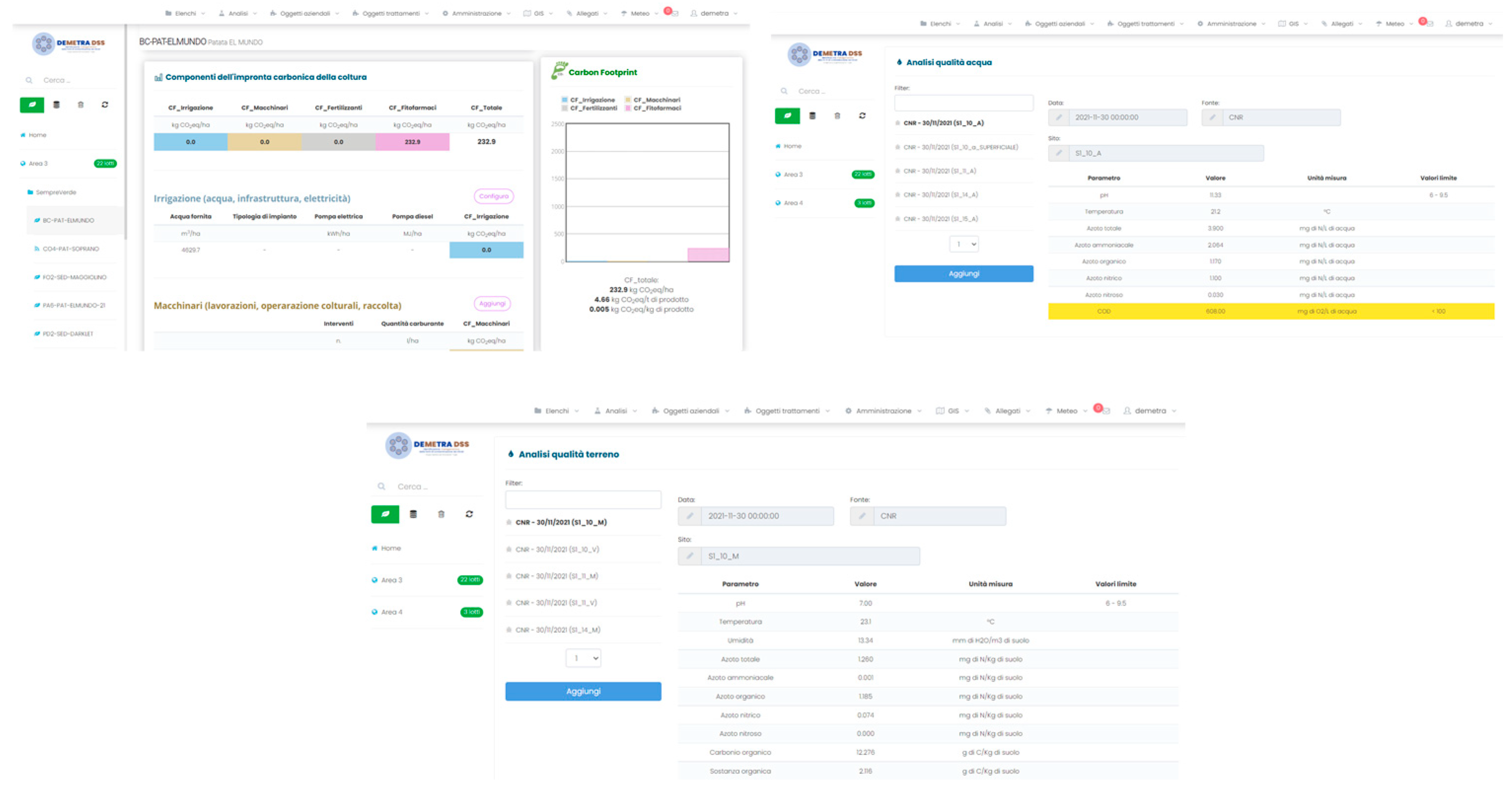
Abstract
Commission Directive 91/676/EC introduced water protection from nitrates from agricultural sources. The Puglia Region approved its ‘Nitrate Action Plan’ (NAP) in 2013, establishing nitrate-vulnerable zones (NVZs), with restrictions on agronomic management and administrative obligations based on territorial studies. However, those aims require appropriate feedback through monitoring activities to identify the real sources of nitrate contamination. The DEMETRA-DSS project arises from a synergy between ICT companies, research institutes and agricultural organizations. The project aims at supporting local institutions in territorial monitoring and management of contamination sources and introduces innovations capable of mitigating the agronomic impact on the territory.
1. Introduction
The Apulia Region started the process of implementation of Directive 91/676/EEC, related to the protection of water from pollution caused by nitrates from agricultural sources (Nitrates Directive), in 2005 with Regional Council resolution no. 1191/2005, wherein it established the inter-departmental working group between the competent offices of the Departments of Public Works, Agri-Food Resources and Ecology. The group was responsible the objective of providing the “perimeter and designation” of vulnerable areas to nitrates of agricultural origin. Moreover, the group was assigned the preparation of the “action program” approved by Regional Council resolutions n. 2036 of 30.12.05 and no. 19 of 23/01/07, implementing all the interventions envisaged and within its competence.
These deeds were drawn up consistently with the Directive itself and with the national transposition decrees, i.e., Legislative Decree 152/99 containing “Provisions on the protection of water from pollution”, repealed and replaced by Legislative Decree n. 152 of 3 April 2006 “Environmental regulations”, which governs and provides the indications for the identification of vulnerable zones, respectively, in art. 92 and in Annex 7/A to the third part of the decree.
Following the processing of the qualitative and quantitative monitoring data of surface and underground water bodies, with the resolution of the Council no. 1317 dated 3 June 2010, four years have elapsed since the first designation of vulnerable zones to nitrates of agricultural origin (NVZs), the first Designations and Perimetrations of the NVZs, approved with D.G.R. n. 2036/2005, acknowledging that, at the conclusion of the monitoring program and subject to the outcome of the further evaluation of the survey results, further investigation would be carried out.
In this direction, the Apulia Region, with the collaboration of the CNR-IRSA, has started the revision activities of the NVZs and the drafting of the new Nitrate Action Plan (PAN) on the basis of the outcomes of investigations related to the assessment of environmental and anthropic state of Apulia and the results of the monitoring and control programs of surface and groundwater activated. Such programs are currently in progress and accompany the verification of the effectiveness of the action program functional to the possible indication of critical aspects to be modified or supplemented.
Specifically, the new action program contains: (i) in-depth analysis of NVZs designated for the Apulian provinces and possible updates according to the provisions of Annex 7—Part A—of Legislative Decree 152/2006; (ii) a critical analysis of the measures of the action plan approved by Regional Council resolution no. 19 of 23.01.07 and identification of any measures intended to improve its effectiveness; (iii) a drafting of the new action program; (iv) a drafting of the Nitrate Communication Plan; (v) in-depth analysis of the activities to control the implementation and effectiveness of the action programs (pursuant to art. 28—Title VIII—of Regional Law 17 of 30 November 2000, concerning the “Conferral of administrative functions and environmental protection”); (vi) indications on community obligations relating to the transmission of information on the state of implementation of the action program and the review procedures, pursuant to art. 75 of Legislative Decree 152/2006 and of the Ministerial Decree of 18 September 2002.
The aforementioned action plan was adopted by the Apulia Region with Resolution of the Regional Council of 1 October 2013, no. 1788, delimiting specific NVZs and establishing constraints on agronomic management and administrative obligations for farmers.
Following the integrated analysis of the information, the modelling investigations conducted, and the assessments carried out in implementation of the Agreement pursuant to DGR no. 2231/2018, the IRSA CNR on 19 November 2019—just call prot. n. AOO_075/13738 of 8.11.2019—presented the proposal for the revision of areas vulnerable to nitrates of agricultural origin.
With DGR n. 389 of 03/19/2020 BURP n. 54 of 17/04/2020, correction of DGR n. 2273 of 02.12.2019—Directive 91/676/EEC, vulnerable areas to nitrates of agricultural origin were revised with the consequent amendment of the DGR n. 955 of 29/05/2019.
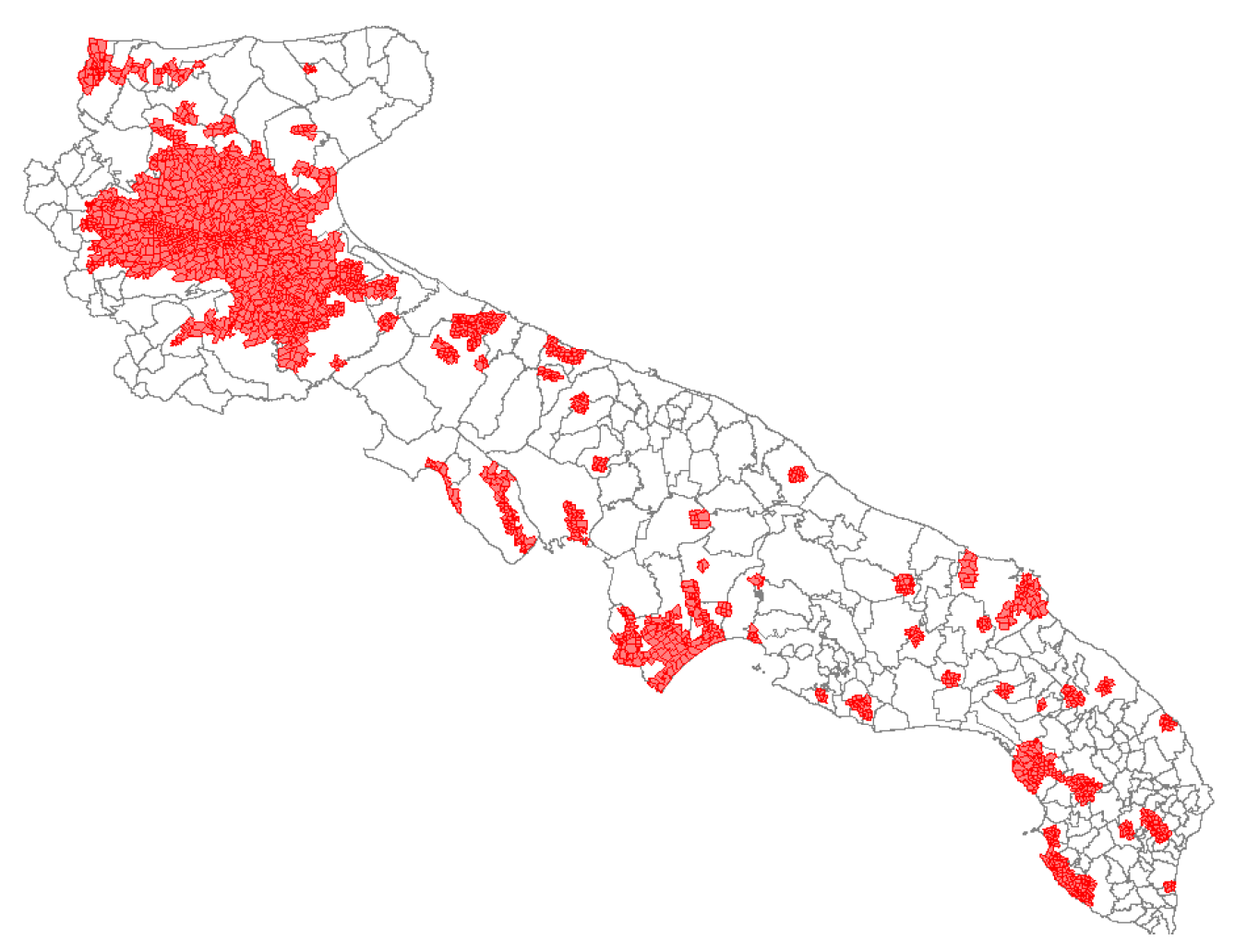
The NVZs, as re-measured (Figure 1), cover a total area of 387.592 ha compared to a previous area of 104.055 ha, as detailed in Figure 1.
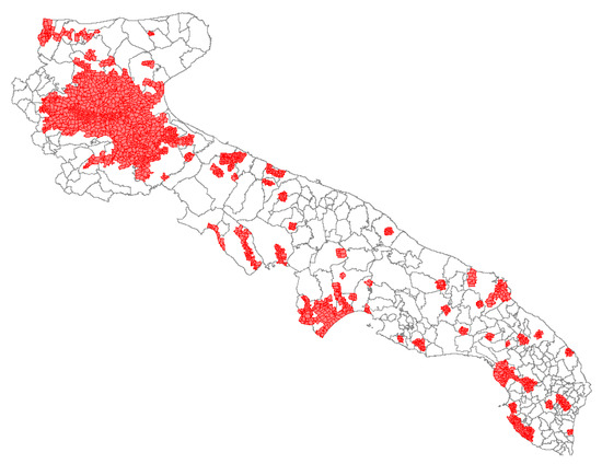
Figure 1.
Designated NVZs for the Puglia Region according to DGR n. 2273 of 02.12.2019 corrected with DGR n. 389 of 03/19/2020.
Within this context, in the framework of the Measure 16.2 of the Regional Rural Development Program (project proposal called ‘DEMETRA-DSS’), the SYSMAN and CNR-IRSA partners have promoted the establishment of an ‘Organizational Group’ (OG), involving horticultural farms (Sempreverde), cooperatives (APOFRUIT, Cantine di Lizzano and Torricella) and sector organizations (Confcooperative Puglia), representing the main regional agricultural production sectors.
The objective of this project proposal is to use biomolecular methods (meta-genomics) for the identification of sources of nitrate contamination in the main areas of the NVZs (and monitoring areas), and also to introduce digital solutions to manage the large amount of data collected (from field information to laboratory results) within a single decision support system (DSS), usable by farmers and competent institutions.
2. Material and Methods
2.1. Analysis and Monitoring
In the DEMETRA-DSS project, soil and water sampling aims to identify possible correlations between soil and underlying groundwater in order to identify possible nitrate contamination from agricultural sources.
In order to be able to carry out the above-mentioned characterization, we need to define if the possible nitrate content in the groundwater comes from an incorrect agricultural practice carried out on the overlying soils, or if it comes from upstream areas (following the preferential direction of water). In particular, if pollution is due to agricultural or another type of contamination, it is important to identify the right sampling procedure that can correlate the data obtained from the analysis of the two matrices both chemically and microbiologically.
For these reasons, before identifying the sampling points, the sites were examined and characterized through the analysis of geospatial information from available databases.
The selection of sampling sites was based on the development of three levels of analysis through the use of thematic shapefiles. Each level determines a critical analysis of the sites that describes their characteristics. The first level concerns the evaluation of the subsoil and aquifers (hydrogeological characteristics of the possible sampling site). In particular, the following spatial information was used: lithology, geomorphological elements, geostructural elements, underground water bodies, and isophreatic description.
The second level concerns the assessment of the situation on the surface and identification of possible natural or anthropic elements that may affect the system, using the following cartographic information: quarries and mines, controlled dungs, and urban centers.
The third level is about the identification of land use (Corine Land Cover) and the possible location of the points in the NVZs.
On the basis of the previous assessments, sampling sites were identified. For each sampling site, one surface groundwater and two soil samples were taken, located relatively upstream and downstream in relation to the groundwater flow [1,2,3].
Regarding water sampling, a purge equal to the volume of the water column is carried out to eliminate stagnant water in the well. At the end of the purge, water sampling is carried out following the APAT-IRSA methods. In particular, a sample was taken for each well for a volume of water equal to 5 L using a sterile PVC tank.
Soil sampling was carried out in conformity with the guidelines set out in the “Official Soil Chemical Analysis Methods” (MUACS) published by the Ministry of Agriculture and Forestry and approved by Ministerial Decree of 13 September 1999.
After the analysis of the sampling area and the identification of the direction of the water table, two samples were taken at each point, one upstream and one downstream, in relation to the trend of the water table flow.
The upstream and downstream samples were the result of two or three sampling points (the sampling points may be different depending on the morphology or conditions of the sampling site) placed along the vertical line with the direction of the water table flow and have formed the mixed composite sample. For each sampling point, the first 10–20 cm of soil was taken, removing the first 2 cm of soil, using a sterile spatula. The samples were placed in sterile bowls, mixed and homogenised as indicated by ministerial guidelines. From each tray, the samples were divided into two aliquots, the first placed in a sterile jar for biomolecular analysis and the second placed in sterile bags for chemical analysis.
All water and soil samples, as per current standards, were refrigerated at 10 °C and transported to the laboratories for project analysis.
Regarding the DEMETRA-DSS project, on the basis of the critical areas of the Apulia region and the characterization of the territory, a total of 77 sites were identified, located throughout the Apulian territory in six monitoring areas, and sampled for chemical analyses, relative to the nitrogen line, and biomolecular analyses.
2.1.1. Chemical Analysis
The soil samples were analyzed according to the Official Methods of Chemical Analysis of Soils (MUACS). In particular, the analysis included temperature, organic carbon (Walkley–Black method), organic matter, total nitrogen, nitrous nitrogen and ammonia nitrogen.
Water analyses included COD, pH, temperature, total nitrogen, nitrous and ammonia nitrogen, according to Analytical Methods for Water—Manual and Guidelines 29/2003—APAT/IRSA-CNR.
2.1.2. Biomolecular Analysis
Biomolecular analyses include DNA extraction, DNA quantification and quality, PCR (polymerase chain reaction) and real-time PCR.
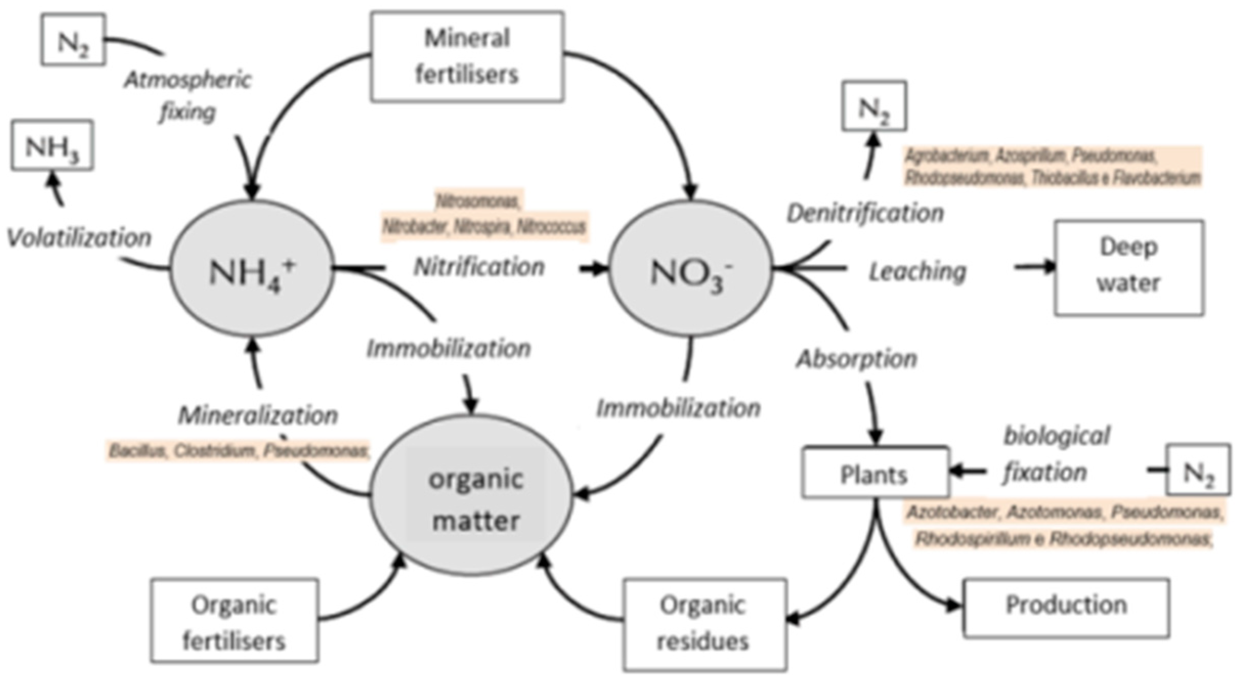
The analysis was focused on microorganisms involved in nitrification and denitrification activities (Nitrosomonas spp., Nitrosovibrio sp., Nitrococcus spp., Nitrobacter spp., Hydrogenophilus sp., Hyphomicrobium sp., Rhodopseudomonas sp., Kingella sp., Neisseria spp., Thiobacillus sp., Halomonas sp., Pseudomonas spp., Xanthomonas sp., Alcaligenes sp., and Paracoccus spp.) [1,2,3]. The identification of bacterial species allows the identification of a group of bacteria linked to the matrix and determines its microbial activity (metabolic functions) (Figure 2) [4].
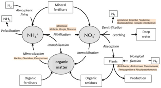
Figure 2.
The nitrogen cycle and related microbial activity.
2.2. The Decision Support System
DEMETRA-DSS information system was divided into two parts, a district decision support system (D-DSS) and a farm decision support system (F-DSS).
To support companies in agronomic management in order to reduce the risk of nitrate leaching, digital and ‘precision’ technologies were applied to optimize the use of water and nitrogen fertilizers in some intensive production systems (e.g., vegetable and fruit crops, vineyards). This was implemented through: (i) the identification of pilot batches for demonstration activities; (ii) the installation of agro-meteorological networks and soil sensors for soil-atmosphere variable monitoring; (iii) the implementation of DSS Bluleaf® (Bari, Italy) for the calculation of crop requirements and management of irrigation and ‘precision’ fertilization.
2.2.1. District Decision Support System (D-DSS)
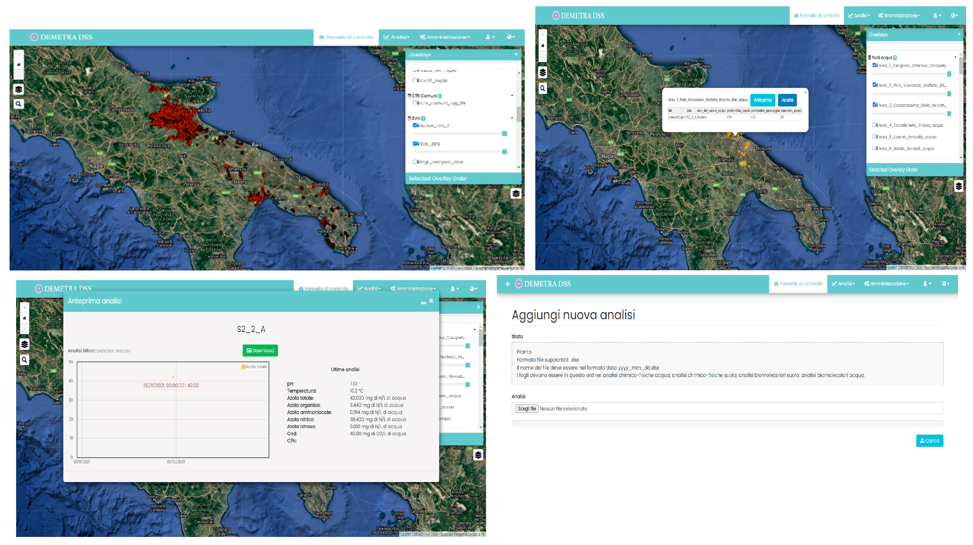
The D-DSS (Figure 3) is intended for use by the institutional bodies responsible for verifying compliance with the restrictions set out in the PAN. In addition, this tool constitutes a database for the interrogation of the PAN and to be aware of the constraints of the NVZs by agricultural companies. The D-DSS should also allow the cataloguing of samplings and sampling points, aimed at processing the chemical-physical and biomolecular analysis of the sites of interest.
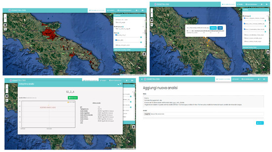
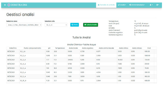
Figure 3.
DEMETRA-DSS: Screenshots from the D-DSS.
In order to facilitate the use of the contents (mainly, by their nature, geo-referenced), it was decided to implement a WEB GIS solution, which makes the common functions of consulting information layers and topographic surveys available to the operator.
From an infrastructural point of view, therefore, the D-DSS consists of three different elements: (i) a database, for storing and historicizing the loaded data; (ii) a map server, for the publication of information layers and the display of user services (WMS); (iii) a client frontend program, accessible from common Internet browsers, which allows the operator to interact with all the system’s features.
As part of the analysis activity, a series of functional requirements were identified: (i) loading and updating by authorized personnel of the information layers relating to the NVZs; (ii) consultation and visualization in the GIS environment of the NVZs; (iii) census, consultation and visualization in a GIS environment of the water/soil sampling points of interest; (iv) loading, consultation and management by authorized personnel of the chemical-physical and biomolecular analysis relating to the water/soil sampling points.
In addition, to ensure maximum flexibility of the system, the D-DSS allows the creation of new users, by defining a type of account for each, in order to filter access to the various functions of the platform.
In order to ensure the interoperability of the D-DSS with the F-DSS (see the following section), a communication channel was implemented which allows the interrogation of the NVZs by individual farmers, through appropriate authentication policies.
2.2.2. Farm Decision Support System (F-DSS)
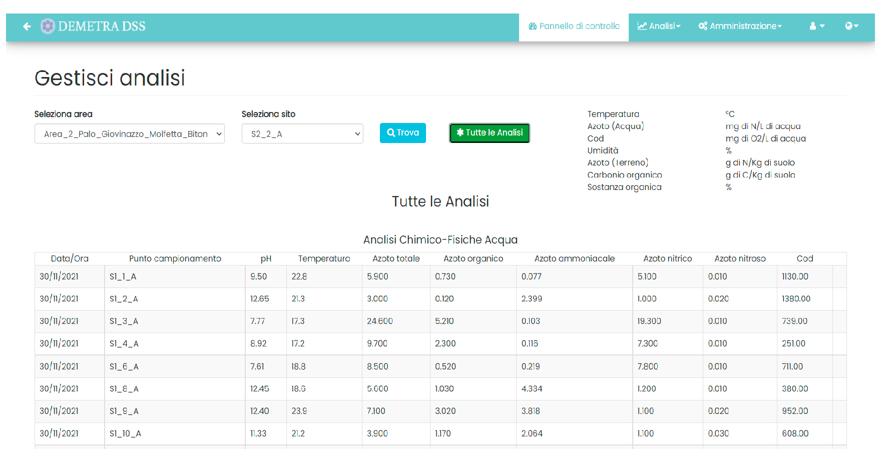
The F-DSS (Figure 4) is a complete and smart solution designed to help farmers to manage everyday activities in the field and manage the sustainable cultivation of crops in compliance with the Nitrates Directive (PAN). It can be used after the definition of farm data, with the possibility of geo-referencing areas, plots and production units. Smart irrigation support is provided thanks to the calculation of the daily water balance and sensors’ data from the field (weather, forecast and soil probes). It is also possible to compute the crop nutrient balance and to consult disease prediction models.

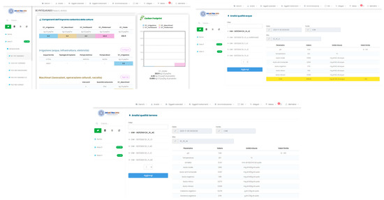
Figure 4.
DEMETRA-DSS: Screenshots from the F-DSS.
For each production area/plot, it is possible to check its status and if it falls within a NVZ, and to update the list of irrigations and fertilizations (also in accordance with possible limitations and restrictions).
The F-DSS also works as a storage for documents, historical reports and chemical-physical and biomolecular analysis of the water/soil sampling points. From an infrastructural point of view, the F-DSS consists of three different elements: (i) a database for storing and historicizing the loaded data; (ii) a backend system that processes user requests and then communicate the output to the frontend; (iii) a frontend, accessible from common Internet browsers, which allows the operator to interact with all system features.
As a result of the functional requirements analysis, a series of tools were developed for: (i) the creation and updating of personal data of farms; (ii) the creation and updating of plots (in relation to main crop data); (iii) loading and consultation (by authorized personnel) of the chemical-physical and biomolecular analyses relating to the water/soil sampling points; (iv) consultation of the status of each plot in its different sections (irrigation, nutrition, disease control and quality); (v) consultation and updating of field treatments; (vi) check if a particular plot falls into a NVZ; (vii) consultation and management of farm areas and plots with GIS tools; (viii) consultation and printing of reports. In addition, to ensure maximum flexibility of the system, the F-DSS allows the creation of new users, by defining a type of account for each, in order to filter access to the various functions of the platform. In order to ensure the interoperability of the F-DSS with the D-DSS, a communication channel was implemented, which, through appropriate authentication policies, allows the updating between the two systems.
3. Results and Discussion
Six study areas were identified at the regional level, with specific reference to the NVZs and monitoring areas, for the characterization of agricultural systems, the assessment of water management and nitrogen fertilizers, and the selection of ‘pilot’ farms. The following project activities were specifically carried out: (i) two sampling campaigns of water and soils and the related analysis with biomolecular methods, for the identification of the sources of nitrate contamination and checks the current perimeter of the NVZs and areas monitoring; (ii) field experimentations with ‘precision’ technologies (models, sensors) and agronomic techniques (cover crops, special fertilizers) for the optimization of the use of water and fertilizers and the management of nitrates on the main regional agricultural systems [5,6,7].
The main effects and expected results at the farm level have been: (i) the optimization of agronomic inputs (water and fertilizers) thanks to the use of ‘precision’ technologies (DSS, IoT sensors, and Big Data); (ii) the adaptation of production techniques (irrigation, fertilization, soil management) to the restrictions and prohibitions imposed in the NVZs (PAN), as well as to the general provisions of the regional ‘Code of Good Agricultural Practice’ (CBPA); (iii) the ‘smart’ and ‘digital’ management of the obligations required by law and the PAN, and in compliance with the environmental standards of international certifications in the field of ‘eco-sustainability’ of production (e.g., Global-GAP) [8,9,10].
As regards the results obtained at the environmental level, the project is supporting: (i) the reduction in the pressure on water ecosystems, due to the reduction in the input of nitrates into the underground water bodies and/or the reduction in the extraction from the aquifer; (ii) the verification and/or improvement of the perimeter of the NVZs, with identification and mapping of the possible causes of contamination.
Additionally noteworthy are the results obtained at the institutional level, through: (i) the support to control activities by the competent institutions on the actual implementation and effectiveness of the PAN, with the use of the DSS and integration/interoperability of ‘middleware’ platforms for data management; (ii) territorial analytics for the acquisition of farm information; (iii) the promotion of a network of stakeholders (research, agricultural sector and competent institutions) interested in the ‘governance’ of the process and the transfer of technologies and know-how.
Regarding social results, it was possible to provide information to the agricultural sector about the objectives of the PAN and to raise the awareness of organizations, cooperatives, farmers and technicians on the problems of sustainable management of water resources and technical training and technology transfer at the regional scale.
Finally, in relation to technological results, the DEMETRA-DSS project has developed a decision support system (DSS) (based on the Bluleaf® platform) for data processing at a regional scale, for use by the institutional subjects concerned (Region, Province, IRSA, ARPA, etc.), which (i) allows to process territorial data and analytical results in an integrated way; (ii) makes the information connected with the regional PAN accessible in a ‘digital’ way; (iii) creates a geo-referenced database capable of making the information of farms and institutions interoperable, and supporting the latter in the territorial management of sources of contamination. The system was developed as an ‘integrated’ DSS (D-DSS + F-DSS platforms), in the web/App versions (accessible from PC and ‘mobile’ devices) with “multi-user” mode and role profiling system, designed also through the involvement of technicians and officials of institutions interested in the development and implementation of the platform for the selected case studies.
The integration of F-DSS and D-DSS platform databases is specifically related to: (i) consultation of the PAN information data; (ii) management of the documentation required by the regulations and by the control procedures; (iii) management of the analytical data of the wells and the certification of the microbiological status of the waters; (iv) access to the virtual “market” to facilitate the exchange of materials (e.g., livestock manure) according to the mandatory restrictions and/or prohibitions of the PAN.
Moreover, through the access to the F-DSS service, all the farms involved in monitoring activities in the various areas, were supported by the simplification of the management of the documentation required by the PAN (company register, Agronomic Use Plan—PUA, periodic communications, etc.), allowing for certification and ‘real-time’ connectivity with the competent authorities, and access to the territorial database for verifying the state of the waters.
4. Conclusions
The DEMETRA-DSS system has made it possible to identify risk areas at a regional level, with particular reference to the NVZ and monitoring areas, for the characterization of agricultural systems, the assessment of water management and nitrogen fertilizers, through monitoring physico-chemical and biomolecular properties of the species linked to the nitrogen cycle; the development of a platform (DSS) at a district scale at the service of the competent institutions, for the management of an inter-operational geo-database based on the acquisition and analysis of data entered by companies and biomolecular surveys at a regional scale, for territorial mapping and management of sources of contamination; and for farms, for access to information and adaptation to the requests of the NAP.
Author Contributions
Conceptualization, A.C. and E.E.R.; methodology, A.C. and M.T.; software, M.T. and E.E.R.; investigation, L.M. and E.L.; writing—review and editing, M.B., E.B., G.P. and V.B.; project administration, A.C. All authors have read and agreed to the published version of the manuscript.
Funding
Puglia Region-Rural Development Program (PSR) 2014-2020 Puglia Article 35 of Regulation (EU) no. 1305/2013-Measure 16 “Cooperation”-Submeasure 16.2 “Support for pilot projects and the development of new products, practices, processes and technologies”. Public Notice approved with D.A.G. n. 194 of 12/09/2018, published in the B.U.R.P. No. 121 OF 20/09/2018 Operational Group “DEMETRA GO” funding number: 94250039305 CUP: B99J20000160009.
Institutional Review Board Statement
Not applicable.
Informed Consent Statement
Informed consent was obtained from all subjects involved in this study.
Data Availability Statement
Not applicable.
Acknowledgments
Thanks to the project partners: Sempreverde S.R.L.; Societa’ Agricola, Apofruit Italia-Soc. Coop. Agricola; Confcooperative-Unione Regionale Di Puglia, Cantina E Oleificio Sociale di Lizzano; Societa’ Cooperativaagricola, Cantina Cooperativa Madonna Delle Grazie di Torricella.
Conflicts of Interest
The authors declare no conflict of interest.
References
- Calabrese, A.; Mandrelli, L.; Blonda, M. Earlier Observation of Applicability of Biomolecular and Chemical Analysis to Soil and Shallow Groundwater in Nitrogen Biogeochemical Local Cycle Evaluation. IOSR J. Biotechnol. Biochem. 2020, 6, 58–69. [Google Scholar]
- Calabrese, A.; Mandrelli, L.; Loi, E.; Blonda, M. Chemical and Microbiological Characterization of Soil under Different Agronomical Use and Practical: First Focus on Nitrogen Cycles. IOSR J. Biotechnol. Biochem. 2020, 6, 45–57. [Google Scholar]
- Casali, L.; Mazzei, L.; Shemchuk, O.; Sharma, L.; Honer, K.; Grepioni, F.; Ciurli, S.; Braga, D.; Baltrusaitis, J. Multifunctional Urea Cocrystal with Combined Ureolysis and Nitrification Inhibiting Capabilities for Enhanced Nitrogen Management. ACS Sustain. Chem. Eng. 2019, 7, 13369–13378. [Google Scholar] [CrossRef]
- Galloway, J.N.; Dentener, F.J.; Capone, D.G.; Boyer, E.W.; Howarth, R.W.; Seitzinger, S.P.; Asner, G.P.; Cleveland, C.C.; Green, P.A.; Holland, E.A.; et al. Nitrogen cycles: Past, present, and future. Biogeochemistry 2004, 70, 153–226. [Google Scholar] [CrossRef]
- Remoundakia, E.; Vasileiou, E.; Philippou, A.; Perrakic, M.; Kousi, P.; Hatzikioseyian, A.; Stamatisd, G. Groundwater Deterioration: The Simultaneous Effects of Intense Agricultural Activity and Heavy Metals in Soil. Procedia Eng. 2016, 162, 545–552. [Google Scholar] [CrossRef][Green Version]
- Maurizio, G. Siti Contaminati: Caratterizzazione, Analisi di Rischio, Tecniche di Disinquinamento; Flaccovio Dario: Palermo, Italy, 2012. [Google Scholar]
- Kanownik, W.; Policht-Latawiec, A.; Fudała, W. Nutrient Pollutants in Surface Water—Assessing Trends in Drinking Water Resource Quality for a Regional City in Central Europe. Sustainability 2019, 11, 1988. [Google Scholar] [CrossRef]
- Smith, R.A.; Alexander, R.B.; Wolman, M.G. Water quality trends in the nation’s rivers. Science 1987, 235, 1607–1615. [Google Scholar] [CrossRef] [PubMed]
- Naser, O.Z.M. Kinetics of Groundwater Nitrate in Soil Leachate in Tulkarem City Using Soil Columns. Ph.D. Thesis, An-Najah National University, Nablus, Palestina, 2011. [Google Scholar]
- Taubert, M.; Stöckel, S.; Geesink, P.; Girnus, S.; Jehmlich, N.; von Bergen, M.; Rösch, P.; Popp, J.; Küsel, K. Tracking active groundwater microbes with D2O labelling to understand their ecosystem function. Environ. Microbiol. 2018, 20, 369–384. [Google Scholar] [CrossRef] [PubMed]
Publisher’s Note: MDPI stays neutral with regard to jurisdictional claims in published maps and institutional affiliations. |
© 2022 by the authors. Licensee MDPI, Basel, Switzerland. This article is an open access article distributed under the terms and conditions of the Creative Commons Attribution (CC BY) license (https://creativecommons.org/licenses/by/4.0/).

