Abstract
Local Climate Zones (LCZs) have become a foundational framework for urban climate modeling, yet their use across model families has not been systematically evaluated. Crucially, the LCZ framework itself has served as a developmental basis, revealing the progression of urban canopy parameterizations (UCP) from early models to the diverse model families currently in use. This evolution is exemplified by systems like the Weather Research and Forecasting (WRF) model, where the application of LCZ has fundamentally shifted from an experimental add-on to a basic, built-in feature of its urban-modeling capabilities. This review synthesizes a decade of LCZ-based studies to clarify how LCZ improves surface representation, enhances comparability, and supports multiscale modeling workflows. It provides a comprehensive overview of peer-reviewed work up to the end of 2024, offering a baseline for understanding the field’s rapid recent growth. Using a structured evidence-mapping approach, we categorize applications into three maturity stages: testing and measurement, operational and planning-oriented applications, and expansions beyond urban climate to chemistry, hydrology, and Earth-system modeling. The assessment covers various iterations of mesoscale systems (WRF, SURFEX/TEB, COSMO), local-scale climatologies (MUKLIMO-3, UrbClim), microscale models (ENVI-met, CFD), and supporting tools including SUEWS, SOLWEIG, RayMan, VCWG, and CESM-CLMU. Results show clear divisions of labor: WRF and SURFEX/TEB anchor process-rich regional simulations; MUKLIMO-3 and UrbClim offer computationally efficient long-horizon or multi-city assessments; ENVI-met and CFD provide design-scale insight when parameterized with LCZ archetypes. Across all families, model skill is strongly constrained by LCZ data quality and by inconsistencies in LCZ to UCP translation. We conclude that advancing LCZ-based urban climate modeling will depend on improved LCZ products, standardized parameter libraries, and formalized cross-scale model couplings that allow existing tools to interoperate more reliably under growing urban-climate pressures.
1. Introduction
The rapid expansion of urban areas worldwide has significantly altered local climates, with profound implications for environmental sustainability, public health, and urban resilience. Among the most notable effects of urbanization is the Urban Heat Island (UHI) phenomenon, defined here as the near-surface air temperature difference between urban areas and nearby rural (or non-urbanized) reference areas. This warming, where urban areas exhibit higher temperatures than their rural surroundings, is primarily due to anthropogenic heat emissions, reduced evapotranspiration, and changes in the surface energy balance. For the purpose of this review, which focuses on near-surface modeling (e.g., 2 m air temperature), the discussion of UHI primarily refers to the thermal differences observed within the Urban Canopy Layer (UCL), the air layer extending from the ground to roughly the mean building height [1]. Beyond temperature anomalies, urbanization also influences wind patterns, humidity levels, and precipitation regimes, further intensifying the environmental burdens faced by urban populations. Accurately modeling these urban climate phenomena is essential for understanding their causes, predicting future impacts, and designing effective mitigation and adaptation strategies. However, a persistent challenge in urban climate modeling lies in the accurate representation of the complex and heterogeneous urban landscape. Traditional land-use and land-cover (LULC) datasets often lack the spatial and morphological specificity required to capture the nuanced interactions between urban form and local climate dynamics. Addressing these limitations is critical to improving the accuracy and decision relevance of urban climate models for decision-making and urban planning.
In response to this data gap, Stewart and Oke [2] introduced the Local Climate Zone (LCZ) classification system, a standardized framework that categorizes urban and rural landscapes based on their morphological and thermal characteristics. This system includes ten built-up zones (e.g., compact high-rise, open low-rise) and seven natural land cover types (e.g., dense trees, water bodies), each defined by characteristic ranges of building height, density, surface roughness, albedo, and thermal admittance. The LCZ framework is particularly suited for urban climate modeling because it provides a thermally homogeneous classification system that can be integrated into a variety of numerical models. The World Urban Database and Access Portal Tools (WUDAPT) initiative further supports the use of LCZs by offering a standardized methodology to generate LCZ maps using open-source satellite imagery and volunteered geographic information [3]. These maps provide a comprehensive and globally consistent dataset that facilitates the integration of LCZs into urban canopy models (UCMs) embedded within mesoscale and microscale climate models.
It is important to note that while the LCZ framework offers a standardized and globally accessible solution for urban classification, it is vital to distinguish it from high-resolution, geometry-based approaches. In regions where detailed Geospatial Information System (GIS) data are available (predominantly in North America and Europe), models like WRF can utilize the National Urban Database and Access Portal Tool (NUDAPT) approach. These ‘geometry-based’ inputs represent the upper tier of urban canopy representation, offering higher physical fidelity than the ‘proxy-based’ LCZ archetypes [4,5,6,7,8]. However, the LCZ framework remains the most viable and complete approach for multi-city comparisons and for regions lacking detailed urban morphology databases.
The integration of LCZs has significantly enhanced the performance of urban climate models, enabling more accurate simulations of urban heat islands, extreme weather events, air quality, and human thermal comfort. Several advanced climate models have adopted LCZ classifications to improve their representation of urban landscapes. Among these, the Weather Research and Forecasting (WRF) model is one of the most widely used due to its flexibility and advanced urban parameterization schemes, including the Single-Layer Urban Canopy Model (SLUCM), Building Effect Parameterization (BEP), and Building Energy Model (BEM) [9]. These schemes allow WRF to model surface-atmosphere interactions, anthropogenic heat fluxes, and the impact of urban morphology on local and regional climates. Other models, such as MUKLIMO_3, COSMO, and SURFEX, have also incorporated LCZs through specialized parameterization schemes, allowing for the analysis of long-term climate projections and the evaluation of urban planning interventions.
Despite its growing adoption, the use of LCZs in urban climate research remains an evolving field. Over the past decade, from 2013 to late 2024, the application of LCZs has expanded significantly, transitioning from an experimental concept to a widely accepted classification standard in urban climate studies. This rapid expansion has recently been synthesized in several significant review articles that cover much of the same time period. For example, Han et al. [10] provided a critical review focusing on the methodological progress and persisting challenges of LCZ mapping, while Li et al. [11] offered a detailed bibliometric analysis of application trends across multiple fields. While reinforcing their findings on general challenges, such as data quality and geographical bias, the present review offers a distinct and necessary contribution by shifting the focus from LCZ methodology and bibliometric trends to operational modeling complexity. Specifically, this article provides the first systematic analysis of the division of labor and functional specialization among various major prognostic and diagnostic urban climate model families (e.g., WRF, SURFEX, PALM-4U) using a novel three-tiered application maturity categorization; Category 1 focuses on model testing and evaluation, examining studies that have validated and assessed the accuracy of LCZ-based classifications and their integration into urban climate models. Category 2 addresses real-world applications, reviewing studies that have implemented LCZs in scenarios such as UHI reduction, climate adaptation strategies, and urban planning initiatives. Finally, Category 3 captures expansion beyond urban climate studies, highlighting the increasing use of LCZs in fields such as air pollution modeling, hydrology, and remote sensing.
This approach allows us to deliver a unique, practical synthesis of the technical requirements and model-specific limitations inherent in advancing LCZ-integrated climate simulations. In general, this review aims to consolidate existing knowledge on the use of LCZs in urban climate research, providing a systematic overview of how LCZs have become a common method for urban environmental classification. While this study incorporates core elements of systematic review methodology, such as predefined search strings and inclusion criteria, it adopts a semi-systematic approach rather than a strictly protocol-bound PRISMA design. This broader interpretive scope is justified by the need to synthesize a decade of diverse applications across multiple modeling families, where a rigid systematic protocol might overlook the nuanced technical transitions from experimental testing to operational planning.
By analyzing the trajectory of LCZ adoption in urban climate research, this review aims to highlight the strengths and limitations of existing studies, identify emerging trends, and propose future directions for LCZ-based modeling. As urban areas continue to evolve under the pressures of climate change and rapid urbanization, understanding the role of LCZs in improving climate model accuracy will be essential for shaping more resilient and sustainable cities. By systematically reviewing the literature and categorizing studies based on their methodological focus, this review provides a comprehensive understanding of how LCZs have evolved into a standard method in urban climate modeling. It establishes a foundation for future research by outlining key developments, assessing methodological advancements, and highlighting the broader applications of LCZ classifications. Through this structured analysis, the study underscores the significance of LCZs in shaping urban climate research and their potential for further interdisciplinary applications.
2. Materials and Methods
2.1. Review Scope and Rationale
This study adopts a structured literature review design to ensure methodological transparency, reproducibility, and broad coverage of Local Climate Zone (LCZ) applications in urban climate modeling. The primary objective is to consolidate a decade of scientific progress, tracing the evolution of LCZs from an experimental concept to a widely used methodological framework in urban climatology. Although this review does not follow the full PRISMA protocol, it integrates core elements of systematic review methodology, including explicit search strategies, predefined inclusion criteria, and transparent synthesis procedures, while maintaining the interpretive depth characteristic of semi-systematic reviews. This design was intentionally selected to enable both breadth and analytical depth, allowing for a nuanced synthesis of methodological advancements across diverse modeling systems and research domains that a traditional systematic review, focused on a single narrow research question, might not fully capture.
2.2. Search Strategy and Database Selection
An extensive and reproducible literature search was conducted across five major scientific databases, including Web of Science, Scopus, Google Scholar, IEEE Xplore, and ScienceDirect. The search period spanned from January 2013 to December 2024, corresponding to the decade during which LCZ-based modeling became a prominent methodological approach following the framework’s introduction by Stewart and Oke [2]. As a preliminary step to the formal search, the specific modeling systems were pre-identified through an initial scoping survey of current research initiatives and the existing body of literature. This survey allowed for the identification of the most frequent numerical frameworks used in conjunction with LCZs, ensuring the selection was representative of the dominant technical pathways in the field. These models were selected because they possess a documented history of community usage in transitioning from default land-use categories to LCZ-based parameterization. This selection covers the full spectrum of urban modeling: mesoscale systems (WRF, COSMO, SURFEX) for regional dynamics, local-scale diagnostic models (MUKLIMO-3, UrbClim) for climatological assessments, and microscale building-resolving models (ENVI-met) for neighborhood design. Including these distinct ‘families’ ensures a comprehensive review that captures the varied technical requirements and implementation strategies across the field.
Boolean search strings were applied to identify relevant publications that combined general and model-specific terminology. For example, a core search query was constructed as: (“Local Climate Zone” OR “LCZ”) AND (“urban climate model” OR “WRF” OR “ENVI-met”) AND (“urban heat island” OR “thermal comfort”).* The full set of terms included “Local Climate Zone,” “LCZ classification,” “urban climate modeling,” “urban canopy model,” “WRF,” “MUKLIMO_3,” “COSMO,” “SURFEX,” “UrbClim,” “ENVI-met,” “SUEWS,” “RayMan,” “CFD,” and “VCWG,” in conjunction with key thematic concepts such as “urban heat island,” “thermal comfort,” “extreme weather,” “urban energy balance,” and “mitigation strategies”. The selection criteria focused on identifying studies that contributed to the methodological advancement and practical implementation of LCZ classifications. These studies were categorized into three maturity stages: (1) testing and measurement, which examining studies that have validated and assessed the accuracy of LCZ-based classifications; (2) operational and planning-oriented applications, involving the implementation of LCZs in real-world scenarios like climate adaptation; and (3) expansions beyond urban climate, highlighting the integration of LCZs into fields such as air pollution modeling, hydrology, and remote sensing.
To ensure a comprehensive overview of the field, we adopted an exhaustive search strategy rather than a selective one. Given that the total volume of literature on this at this specific intersection remains manageable, no exclusion criteria were applied to the identified set. Consequently, all identified papers were included in the final analysis. It is important to note that while the modeling systems were selected using an exhaustive, non-restrictive strategy, the associated literature was subsequently screened using article-level eligibility criteria outlined in Section 2.3.
2.3. Eligibility Criteria for Literature Inclusion
To ensure the dataset consistency and scientific integrity of the dataset, strict inclusion and exclusion criteria were established prior to data collection. Only peer-reviewed journal articles published between 2013 and 2024 and written in English were considered. Studies were included if they explicitly employed LCZ classifications within urban or regional climate modeling frameworks and addressed at least one key urban climate phenomenon, such as the urban heat island, human thermal comfort, air quality, or climate adaptation. Non-peer-reviewed sources, including conference proceedings, theses, and technical reports, were excluded, as were studies that mentioned LCZs but did not integrate them into modeling processes or that focused solely on land-use classification without a climate modeling component. These criteria ensured that only methodologically robust and directly relevant works were incorporated into the review.
2.4. Screening and Selection Process
The literature screening and selection process followed a four-stage protocol designed to enhance reproducibility and methodological transparency. The initial phase involved removing duplicate records across databases. This was followed by title and abstract screening to identify potentially relevant studies. The third phase consisted of full-text evaluation based on the established inclusion criteria, ensuring that only studies demonstrating substantive LCZ integration were retained. The final phase involved an eligibility assessment, during which studies were examined for methodological rigor, clarity of modeling implementation, and relevance to the review’s objectives. While a formal PRISMA flowchart was not used, the process adhered to the same logic of systematic filtering and quality appraisal, thereby ensuring a comprehensive and unbiased dataset.
2.5. Data Extraction and Categorization Framework
All eligible studies were systematically analyzed through a standardized data extraction framework that captured essential bibliographic, methodological, and thematic information. Each study was documented with reference to its authorship, publication year, study area, modeling system, parameterization approach, objectives, and principal findings. To facilitate structured analysis, the collected studies were organized into three thematic domains that reflect the trajectory of LCZ applications in urban climate research. The first domain, termed “testing and measurement,” includes studies that validated and assessed the performance of LCZ-based models using remote sensing, GIS analysis, or in situ data. The second domain, “application,” encompasses studies integrating LCZ classifications into numerical modeling systems such as WRF, MUKLIMO_3, COSMO, SURFEX, ENVI-met, and UrbClim to simulate phenomena including urban heat islands, human thermal comfort, and extreme events. The third domain, “expansion,” highlights studies that extended the use of LCZs beyond urban climatology, for instance into hydrology, air quality modeling, and ecological analysis. This threefold categorization allowed for a coherent synthesis of trends, innovations, and methodological progress across disciplines.
2.6. Methodological Limitations
This review is limited to studies published in peer-reviewed journals and written in English, which may have resulted in the exclusion of relevant research published in other languages or presented in conference proceedings. While this decision ensured methodological consistency and quality assurance, it may also introduce publication and language bias. Furthermore, the exclusion of grey literature and non-peer-reviewed sources was intended to preserve analytical rigor, but it inevitably narrows the breadth of the reviewed evidence base.
Although this review follows a structured and reproducible approach, it does not include a formal quantitative meta-analysis or a statistical assessment of publication bias. The synthesis remains interpretive in nature, focusing on methodological trends and cross-disciplinary linkages rather than statistical effect sizes. Nevertheless, the review provides a transparent, comprehensive, and academically rigorous framework for understanding the evolving role of LCZs in urban climate modeling and offers a reliable foundation for future research seeking to enhance urban climate model performance through standardized morphological classification systems.
2.7. Geographical Distribution of Studies
The geographical distribution of LCZ-based urban climate studies reveals strong regional patterns in model selection and research emphasis. WRF dominates globally, with dense clusters across East Asia (China, Japan, South Korea), South Asia, and major urban centers in Europe and North America, reflecting its role as the primary mesoscale framework for LCZ integration. ENVI-met studies are concentrated in Europe, the Middle East, South Asia, and parts of China, consistent with its use in micro-scale urban design and thermal comfort assessments. MUKLIMO_3 exhibits a distinctly Central European focus, including Austria, Hungary, Slovakia, and the Czech Republic, aligning with its development and operational use within the DWD community. UrbClim applications cluster in Western Europe (Belgium, Portugal, Spain) and parts of South Asia, reflecting its computational efficiency for UHI assessment. SURFEX and COSMO (TERRA_URB) appear primarily in Western and Central Europe, as well as selected African and Asian cities, indicating their regional adaptation within European research institutions. Supporting models such as SUEWS, SOLWEIG, RayMan, CFD, and PALM-4U appear more sparsely, often linked to targeted microclimate or model-coupling studies in Europe and selected global case locations. Overall, the global evidence map (Figure 1) depicts the location of the selected peer-reviewed studies using distinct symbols to represent the specific urban climate model employed.
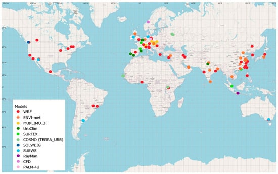
Figure 1.
Spatial distribution of the study areas of LCZ-related modeling initiatives from 2013 to 2024.
3. LCZ Integration by Model Family
This section provides a systematic analysis of how LCZ classifications have been integrated into major urban climate modeling frameworks. For each model family, the review outlines how LCZ information is incorporated, the typical modeling configurations, representative applications, and the main insights reported in the literature. A key advantage of the LCZ system is that it offers a relatively simple yet thermally meaningful urban surface classification. This allows LCZs to be used not only for describing urban measurement environments and for mapping, but also as static input data for urban-scale weather and climate models. Because areas within each class are assumed to be thermally homogeneous, LCZs can effectively represent the characteristic temperature responses of different urban zones.
Several studies rely on alternative surface datasets that were developed for other purposes and based on different criteria, such as CORINE (Coordination of Information on the Environment) [12], Urban Atlas [13], ECOCLIMAP [14], and USGS (United States Geological Survey) [15]. However, if the underlying surface database does not adequately represent urban thermal conditions, then improvements in urban models or parameterizations cannot substantially enhance model accuracy. This challenge was recognized early by the urban climate and weather-modeling community, which increasingly adopted LCZs as a surface database for numerical simulations. The diffusion of the LCZ concept has been further supported by the WUDAPT project, whose core objective includes promoting the use of LCZs in urban modeling experiments [3].
3.1. Weather Research and Forecasting (WRF)
The Weather Research and Forecasting (WRF) model has been the most extensively employed mesoscale framework for the incorporation of LCZ data in urban climate simulations. WRF’s development is a collaborative effort, primarily initiated and maintained by the National Center for Atmospheric Research (NCAR) and its consortium partners (NOAA, U.S. Air Force, etc.), serving as a global community standard for research and operational forecasting. Its flexible architecture, coupled with multiple urban canopy schemes, notably the Single-Layer Urban Canopy Model (SLUCM) [16], the Building Effect Parameterization (BEP) [17], and the Building Energy Model (BEM) [18], provides a robust foundation for translating LCZ classes into physically consistent surface parameters. These schemes allow the inclusion of LCZ-derived urban canopy parameters (UCPs) such as building height, plan area fraction, roughness length, albedo, vegetation fraction, and heat capacity, which are used to replace default USGS or MODIS (Moderate Resolution Imaging Spectroradiometer) land-use categories in WRF input files.
Over the past decade, LCZ–WRF coupling has evolved substantially, building upon foundational work that examined how idealized urban morphologies influence local energy fluxes and atmospheric stability [19]. Later, Brousse et al. [20], advanced this concept by implementing LCZ-informed surface datasets within WRF’s urban parameterization, demonstrating that morphological diversity directly enhances the spatial realism of simulated urban heat islands (UHIs). Subsequent developments by Brousse et al. [21], and Nadimpalli et al. [22] further refined LCZ-WRF integration using lookup tables that assign quantitative UCP values to each LCZ class based on morphological indicators derived from GIS or remote-sensing analysis. These studies typically operated at spatial resolutions between 100 m and 1 km, achieving improved depiction of intra-urban thermal gradients and reduced mean bias errors in 2 m air temperature when compared with standard land-use classifications.
A number of studies have emphasized the role of WRF’s different urban schemes in mediating the effects of LCZ parameterization. For example, Martilli et al. [17] and Salamanca and Martilli [18] established the conceptual and physical basis for BEP and BEM, which later became the default frameworks for LCZ integration in WRF. Subsequent validation studies [20,23,24], demonstrated that coupling LCZ data with BEP/BEM significantly improves the spatial and vertical representation of urban heat islands compared to simpler schemes such as SLUCM. Further investigations in Dijon [25], Hong Kong [26], and Beijing [27] confirmed that LCZ-informed urban canopy parameters (UCPs) enhance the model’s ability to reproduce the intensity and diurnal variability of near-surface air temperature. Similarly, other studies [28,29,30] reported that morphological realism introduced by LCZ-based UCPs improved simulations of nocturnal UHI intensity and reduced daytime temperature biases, particularly in compact and high-rise LCZ classes.
Several recent studies have expanded the LCZ–WRF framework toward applied and interdisciplinary domains. For example, Patel et al. [31] and Wang [32] used LCZ-based configurations to examine extreme precipitation and UHI circulation patterns, while Sobrinho et al. [33] and Kalogeri et al. [34] applied the model to evaluate urban heat adaptation measures such as green roofs, cool surfaces, and vegetation strategies. Other works demonstrated how LCZ–WRF coupling can quantify the benefits of urban adaptation and cooling technologies across cities in North America and Europe [35]. Meanwhile, Vogel et al. [36] and Pan et al. [37] showcased model fusion approaches, coupling WRF with PALM-4U and ENVI-met, respectively, to link mesoscale climate dynamics with microscale comfort outcomes.
Collectively, these findings confirm that LCZ-based parameterization enhances the physical realism and transferability of urban representations within WRF, improving both the spatial structure and magnitude of simulated temperature, energy fluxes, and hydrometeorological fields. The systematic improvements in bias reduction and spatial heterogeneity representation reported across studies indicate that LCZ–WRF coupling has evolved from a methodological innovation into an emerging standard in urban climate modeling. A notable trend is the shift from Category 1 to Category 2/3 since 2020. Most LCZ–WRF studies still emphasize model evaluation and testing (Category 1), though a growing share since 2020 has shifted toward urban planning, adaptation, and interdisciplinary applications (Category 2–3), reflecting the model’s maturation and expanding role in operational climate assessment. Table 1 summarizes representative studies, highlighting their Model Schemes, which refer to the specific urban canopy parameterization (e.g., SLUCM or BEP/BEM) selected within the modeling system. In addition, the Category column indicates the study’s primary focus based on the three maturity stages: 1 (Testing and Measurement), 2 (Operational and Planning-Oriented Application), or 3 (Expansion beyond urban climate).

Table 1.
Key features of LCZ-based urban weather and climate model studies using WRF.
3.2. MUKLIMO-3
The MUKLIMO-3 model is a non-hydrostatic, local-scale urban climate model developed by the German Weather Service (Deutscher Wetterdienst-DWD) to analyze urban microclimates, particularly the UHI effect and long-term thermal stress under changing climatic conditions [101]. A defining strength of MUKLIMO-3 lies in its ability to simulate complex urban processes at fine spatial resolutions (often down to a few hundred meters) while maintaining computational efficiency. This balance between detail and scalability has made it an indispensable tool for assessing how urban form influences microclimate, large-domain and long-term, long-term simulations [102]. Unlike many mesoscale systems, MUKLIMO-3 contains no predefined surface classification, which makes it inherently adaptable for integrating LCZ data. This flexibility allows researchers to assign parameter values directly from LCZ morphological descriptors (such as built fraction, vegetation cover, and building height) ensuring that surface characteristics are physically consistent with urban form. Through the combination of idealized numerical simulations with the cuboid statistical method, the model can produce multidecadal climatologies of heat-stress indicators while retaining computational parsimony [102].
The application of LCZ data within MUKLIMO-3 has broadened its utility across both research and planning contexts. Early integrations, such as those by Skarbit and Gál [103], demonstrated that LCZ parameterization substantially improves the model’s ability to reproduce spatial variations in air temperature and heat stress across cities with heterogeneous morphology. Subsequent studies expanded this approach to future climate scenarios: Bokwa et al. [104] and Geletič et al. [105] employed the model to project how climate change may intensify urban heat exposure, finding that LCZ-based configurations capture local adaptation potential more realistically than generic land-use inputs. Validation efforts by Bokwa et al. [106] confirmed that MUKLIMO-3 reproduces observed temperature fields and heat-stress indices with high accuracy when driven by LCZ-derived surface data.
The model’s efficiency has also encouraged its use in urban planning and scenario testing. For example, Geletič et al. [107] applied LCZ-informed MUKLIMO-3 simulations to evaluate different mitigation strategies under future climate conditions, while Gál et al. [108] analyzed the implications of alternative land-use plans on local thermal comfort. In both cases, the LCZ framework enabled the translation of morphological design changes into quantifiable climatic responses. In terms of study focus, most MUKLIMO-3 studies fall under Category 2 (Application), demonstrating how LCZ-based simulations have evolved from validation to applied research in urban heat exposure, climate-risk mapping, and urban planning. Only two studies [106,109] are primarily methodological, focusing on idealized testing or intercity validation.
Overall, LCZ-MUKLIMO-3 coupling has proven particularly effective for characterizing microclimatic risks under projected climate conditions, offering a means to generate 30-year averages of multiple heat-stress indices with relatively modest computational cost. The reviewed applications (Table 2) illustrate that MUKLIMO-3’s methodological simplicity, together with the morphological precision afforded by LCZ data, makes it a reliable platform for both academic research and policy-oriented assessments of urban climate resilience.
Table 2.
Key features of LCZ-based urban weather and climate model studies using MUKLIMO_3.
3.3. COSMO (Consortium for Small-Scale Modeling)
The Consortium for Small-scale Modeling (COSMO) is an international organization formed by the national weather services of multiple European countries (including Germany, Italy, Poland, Switzerland, and Greece) to develop, maintain, and share a high-resolution, non-hydrostatic numerical weather prediction model. The model and its regional climate application (COSMO-CLM) are collaboratively developed and maintained by the member services, with institutions like the German Weather Service (DWD) playing a prominent role [114]. Its architecture enables high-resolution simulation of mesoscale processes, including those arising from urban land-surface heterogeneity, and it has increasingly been employed to investigate urban-induced modifications of temperature, wind, and energy fluxes across large metropolitan domains. Central to COSMO’s urban functionality is the TERRA-URB parameterization scheme [115], which refines the representation of surface-atmosphere exchanges by accounting for anthropogenic heat release, storage of sensible heat within built materials, and modifications to aerodynamic roughness caused by urban structures. This scheme has made COSMO suitable for exploring the dynamic impacts of urbanization on regional climate variability and extreme weather events.
The incorporation of LCZ data into COSMO marks a major methodological advance in improving urban surface representation. By replacing default land-use categories with LCZ-derived parameters (such as building height, impervious fraction, and surface albedo) researchers have been able to achieve more realistic spatial patterns of urban energy balance. Early LCZ-enhanced COSMO applications, such as those conducted for Moscow [116], demonstrated significant improvement in reproducing nocturnal heat-retention patterns and the spatial extent of the urban heat island (UHI). Similarly, Brousse et al. [21] applied an LCZ-based configuration to a set of African cities, showing that the inclusion of morphological data improved near-surface temperature and wind-field simulations in regions where conventional land-use datasets are often unreliable. Recent work by Van de Walle [117] extended this approach by coupling LCZ-derived surface parameters with observational validation, confirming that LCZ integration enhances model skill in both temperate and tropical environments. Despite the still limited number of LCZ-COSMO studies (Table 3), the results consistently highlight the model’s capacity to capture cross-boundary climatic interactions (for instance, the downwind propagation of urban heat signatures across suburban and rural areas). This makes COSMO particularly valuable for investigating large urban agglomerations and regional-scale feedbacks, such as the interplay between urban morphology, mesoscale circulation, and convective activity.
The integration of the LCZ framework within the COSMO (TERRA_URB) model family remains at a relatively early stage of development but represents a crucial advancement in regional-scale urban climate modeling. Most COSMO-based LCZ studies focus on testing and refining the model’s urban parameterizations, particularly the TERRA_URB scheme, which enhances the representation of urban surface energy exchanges and canopy-layer heat storage. Studies in Moscow [116,118] have demonstrated the model’s sensitivity to morphological variability, providing valuable insights into how LCZ-based inputs influence mesoscale thermal and dynamic processes.
Although applications remain limited, these studies collectively position COSMO as a promising intermediate-scale modeling platform, bridging the gap between localized microscale simulations and regional climate models. Its capacity to incorporate LCZ-based surface parameters allows for consistent cross-regional analyses of urban heat islands, temperature variability, and land–atmosphere interactions. The existing body of work underscores the model’s strength in validation-oriented and methodological research (Category 1) while indicating high potential for expansion into urban planning and adaptation studies (Category 2) as more refined LCZ datasets and parameter libraries become available.
Table 3.
Key features of LCZ-based urban weather and climate model studies using COSMO.
Table 3.
Key features of LCZ-based urban weather and climate model studies using COSMO.
| Study Area | Topic | Model Scheme | Year | Reference | Category |
|---|---|---|---|---|---|
| Moscow, Russia | Climate model, temperature Profile analysis | COSMO (TERRA_URB) | 2018 | [116] | 1/Testing |
| Kampala, Uganda; Dakar, Senegal | Climate model, Health-related studies | COSMO (TERRA_URB) | 2019 | [21] | 2/Application |
| Kampala, Uganda | Climate model, Land surface temperature validation, Urban climate analysis | COSMO (TERRA_URB) | 2020 | [117,119] | 1/Testing |
| Moscow, Russia | Climate model, Investigation of LCZ parameterization | COSMO (TERRA_URB) | 2020 | [118] | 1/Testing |
| Italy and Russia | Climate model, Land surface temperature, Urban Canopy | COSMO (TERRA_URB) | 2021 | [120] | 1/Testing |
3.4. SURFEX (Surface Externalisée)
The SURFEX (Surface Externalisée) modeling platform provides a unified framework for coupling land surface processes with atmospheric models. SURFEX was developed and is principally maintained by Météo-France, particularly within the research teams of the Centre National de Recherches Météorologiques (CNRM) [121]. A key component of SURFEX is the Town Energy Balance (TEB) scheme [122], which represents urban areas using detailed building geometry and surface energy budgets. This scheme models critical urban processes such as anthropogenic heat fluxes, heat storage, and urban ventilation, making it a comprehensive tool for studying urban climates.
The introduction of ECOCLIMAP-SG within the SURFEX/TEB framework [123] has substantially improved the model’s capacity to represent urban morphological diversity through the LCZ classification system. This advancement has enhanced the accuracy of UHI simulations and thermal comfort assessments by standardizing surface parameters across heterogeneous urban fabrics. Early LCZ-based applications, such as those by Harshan et al. [124] in Singapore and Ibitolu [125] in Toulouse, validated the model’s performance in capturing surface energy fluxes and local UHI intensity under tropical and temperate conditions. Similarly, Kwok et al. [126] applied Meso-NH SURFEX to evaluate urban thermal comfort in Hong Kong, while Caluwaerts et al. [127] demonstrated the model’s interoperability by coupling ALARO-SURFEX with UrbClim for regional urban climate simulations in Ghent.
Beyond improving model accuracy, the LCZ–SURFEX/TEB framework offers significant advantages in standardization and comparability. The ECOCLIMAP-SG database provides harmonized morphological and radiative parameters derived from LCZ classes, enabling consistent multi-city modeling without the need for locally calibrated datasets. This has facilitated the framework’s integration into regional climate projects and climate services, where reproducibility and spatial consistency are critical. Coupling SURFEX with mesoscale atmospheric models such as Meso-NH and ALARO [127,128] allows LCZ information to propagate through the boundary layer, thereby improving the downscaling of regional climate projections to the urban scale. Furthermore, SURFEX’s compatibility with the ALADIN operational forecasting system [129] used in several European national meteorological services enhances its potential for urban parameterization in short-term forecasting, enabling the translation of LCZ-based research into applied climate services for urban environments.
Although the number of LCZ-based SURFEX applications remains modest compared with WRF, their results collectively demonstrate the platform’s strength in linking morphological realism with thermodynamic accuracy. The reviewed studies (Table 4) indicate that the SURFEX family, particularly through its TEB module, has evolved from a diagnostic modeling tool toward an applied decision-support system capable of linking microclimate assessment with planning-relevant outcomes. The inclusion of LCZ-based land-use information enhances its generalizability across cities and climates, supporting standardized evaluation of urban thermal dynamics. Most studies align with Category 2 (Application of the Model), reflecting a mature modeling phase where SURFEX/TEB is increasingly applied for forecasting, mitigation, and comfort optimization rather than purely methodological testing.
Table 4.
Key features of LCZ-based urban weather and climate model studies using SURFEX.
3.5. UrbClim
The UrbClim model was developed as a simplified yet physically based urban climate system designed to perform high-resolution simulations of surface temperature and near-surface meteorological conditions at very low computational cost. Its design combines a surface–atmosphere interaction scheme that captures the key physical processes governing energy fluxes in urban environments with a three-dimensional boundary-layer module that reproduces mesoscale atmospheric dynamics. UrbClim was developed and is maintained by the VITO Institute (Flemish Institute for Technological Research) in Belgium. The model’s principal goal is to provide faster urban simulations than traditional high-resolution mesoscale climate models while maintaining acceptable physical realism [130].
Early applications of UrbClim focused on simulating present and future UHI patterns at continental and regional scales. Studies by Zhou et al. [131] demonstrated its suitability for long-term urban-climate assessments, showing that the model successfully reproduces spatial temperature gradients across large metropolitan areas while remaining computationally efficient. The model’s capacity for large-scale application has since enabled its use within major climate-service projects, such as those under the European Copernicus Climate Change Service, providing urban temperature and heat-stress projections for hundreds of European cities. The integration of LCZ data into UrbClim represents an important step in improving its morphological realism. The LCZ framework enables the model to incorporate detailed urban surface descriptors (such as built fraction, vegetation cover, albedo, and roughness length), thereby refining the spatial differentiation of urban classes within the simulation domain. Several LCZ-based studies (Table 5) have highlighted these advantages. For instance, Sharma et al. [132] and Verdonck et al. [133] applied UrbClim with LCZ classifications to analyze UHI intensity and spatial extent under varying urban forms, reporting improved agreement with observed temperature distributions compared to simulations using generic land-use data.
Further developments have broadened the scope of UrbClim–LCZ applications beyond temperature mapping. Maheng et al. [134] employed the model to evaluate urban planning scenarios, demonstrating its utility for testing design interventions such as increasing vegetation or altering surface materials. Similarly, Gilabert et al. [135] applied LCZ-informed UrbClim simulations to assess human thermal comfort, highlighting the model’s ability to translate morphological information into meaningful comfort and exposure indicators. More recently, Reis et al. [136] expanded the analysis to include future climate scenarios, confirming that LCZ integration improves model skill in projecting both the magnitude and spatial variability of UHIs under warming conditions. Further evidence corroborates that LCZ-informed UrbClim configurations enhance model accuracy by better representing intra-urban variability, particularly between dense urban cores and peripheral low-rise zones [136,137]. These studies emphasize that while UrbClim’s simplified dynamics limit its ability to resolve detailed turbulence and building-scale processes, the LCZ coupling greatly strengthens its capacity to capture mesoscale heterogeneity.
In summary, the reviewed studies confirm that UrbClim, when combined with LCZ-based surface parameterization, provides a powerful and efficient platform for analyzing both current and projected urban climate conditions. Its speed, simplicity, and compatibility with LCZ data make it ideal for multi-scenario assessments of heat exposure, human comfort, and land-use planning. Overall, the model’s integration with LCZ datasets bridges the gap between operational efficiency and morphological realism. Overall, UrbClim studies predominantly belong to Category 2 (Application of the Model), underscoring the model’s maturity and practical utility. Its computational efficiency makes it an excellent platform for city-scale climate risk assessment and policy-oriented urban planning.
Table 5.
Key features of LCZ-based urban weather and climate model studies using UrbClim.
Table 5.
Key features of LCZ-based urban weather and climate model studies using UrbClim.
| Study Area | Topic | Model Scheme | Year | Reference | Category |
|---|---|---|---|---|---|
| Delhi, India | Climate model, UHI analysis | UrbClim | 2016 | [132] | 2/Application |
| Brussels, Antwerp, Ghent, Belgium | Climate model, UHI analysis | UrbClim | 2017 | [133] | 2/Application |
| Delhi, India | Climate model, Climate change assessment | UrbClim | 2019 | [138] | 2/Application |
| Colombo, Sri Lanka | Climate model, UHI analysis, Urban planning | UrbClim | 2019 | [134] | 2/Application |
| Brussels, Belgium | Climate risk assessment | UrbClim | 2019 | [139] | 2/Application |
| Barcelona, Spain | Climate model, Heatwave, Human comfort | UrbClim | 2021 | [135] | 2/Application |
| Lisbon, Portugal | Climate model, UHI analysis | UrbClim | 2022 | [136] | 2/Application |
| Seville, Spain | Climate model, UHI analysis | UrbClim | 2023 | [137] | 2/Application |
| Barcelona, Spain | UHI analysis | UrbClim | 2023 | [140] | 2/Application |
3.6. ENVI-Met
ENVI-met is a microscale, three-dimensional numerical model developed to simulate the interactions between urban surfaces and the atmosphere, with a particular focus on human thermal comfort and microclimatic variability. Originally developed by Michael Bruse at the University of Bochum, the model is currently maintained and further developed by ENVI-met GmbH in cooperation with academic partners. In 2024, ENVI-met was acquired by the Finnish company One Click LCA and became part of their software portfolio [141,142]. Based on a three-dimensional computational fluid dynamics (CFD) core, ENVI-met explicitly resolves the exchange of momentum, heat, and moisture within the urban canopy layer, allowing for detailed assessment of how morphology, vegetation, and materials interact to shape local climate conditions. The incorporation of LCZ data into ENVI-met simulations has recently emerged as an effective method for standardizing model input configurations and linking microscale findings with broader urban typologies. By parameterizing LCZ-based attributes, researchers can create scenarios representative of broader LCZ types, facilitating the generalization of neighborhood-scale findings. This approach enables systematic comparison of thermal and airflow patterns across multiple urban forms, thereby improving the transferability of microscale findings to citywide assessments [143].
Although originally designed for micro-scale studies, LCZ classifications have been integrated into ENVI-met to facilitate a broader understanding of urban-scale relationships [144]. By incorporating LCZ-based surface data, the model can provide more accurate thermal simulations across diverse urban typologies [145]. Studies summarized in Table 6 show that LCZ-informed ENVI-met simulations provide a robust framework for quantifying thermal comfort indices such as Predicted Mean Vote (PMV), Physiological Equivalent Temperature (PET), and Universal Thermal Climate Index (UTCI) under both current and future climatic conditions [146]. Recent applications have extended LCZ-ENVI-met modeling beyond comfort analysis to explore urban design optimization and adaptation strategies [147]. Chen et al. [148] applied the LCZ framework to evaluate microclimatic impacts of vegetation enhancement and surface retrofitting, demonstrating that LCZ-based parameterization supports consistent comparison across urban typologies and climates.
Beyond ENVI-met, other CFD-based models have adopted LCZ-informed setups to explore airflow dynamics, shading effects, and heat dissipation under varying morphological scenarios. These models often complement ENVI-met by allowing more flexible boundary conditions or turbulence schemes, enhancing cross-validation and expanding the analytical capacity of microscale studies. Given its suitability for human comfort assessment, several studies have examined comfort–LCZ relationships [144,149,150,151,152]. Collectively, the literature demonstrates that LCZ-informed ENVI-met and CFD modeling provides an essential link between fine-scale process understanding and urban-scale typological analysis. Predominantly classified under Category 2 (Application of the Model), ENVI-met has proven instrumental in supporting evidence-based urban design and climate adaptation planning, often serving as the final analytical stage following coarser-scale modeling or LCZ mapping. Its frequent use in studies addressing thermal comfort indices, green infrastructure, and micro-scale UHI mitigation underscores its position as a cornerstone tool for operational urban climate evaluation. As computational performance continues to improve, ENVI-met’s LCZ-based implementations are expected to play an even greater role in integrated, multi-scale modeling frameworks that connect human comfort, morphology, and energy balance across spatial hierarchies.
Table 6.
Key features of LCZ-based urban weather and climate model studies using ENVI-met.
Table 6.
Key features of LCZ-based urban weather and climate model studies using ENVI-met.
| Study Area | Topic | Model Scheme | Year | Reference | Category |
|---|---|---|---|---|---|
| Oberhausen, Germany | Microclimate model, Climate change, Urban planning | ENVI-met | 2014 | [153] | 2/Application |
| Phoenix, USA | Microclimate model, Urban planning | ENVI-met | 2014 | [154] | 2/Application |
| Colombo, Sri Lanka | Microclimate model, Urban planning | ENVI-met | 2015 | [155] | 2/Application |
| Glasgow, United Kingdom | Microclimate model, Urban planning | ENVI-met | 2015, 2020 | [156,157] | 2/Application |
| Colombo, Sri Lanka | Microclimate model, Climate change, Human comfort | ENVI-met | 2017 | [143] | 2/Application |
| Beijing, China | Microclimate model, Human comfort | ENVI-met | 2017 | [144] | 2/Application |
| Vienna, Austria | Microclimate model, City-scale analysis | ENVI-met | 2018 | [146] | 1/Testing |
| Nanjing, China | Microclimate model, Microclimate analysis based on the LCZ system | ENVI-met | 2019 | [145] | 1/Testing |
| Kolkata, India | Microclimate model, Urban planning | ENVI-met | 2019 | [158] | 2/Application |
| Al-Ain, United Arab Emirates | Microclimate model, UHI analysis | ENVI-met | 2020 | [147] | 2/Application |
| Dubai, United Arab Emirates | Microclimate model, Urban planning | ENVI-met | 2020 | [159] | 2/Application |
| Nagpur, India | Microclimate model, UHI analysis | ENVI-met | 2020 | [160] | 2/Application |
| Changsha, China | Microclimate model, Urban planning | ENVI-met | 2020 | [161] | 2/Application |
| Roorkee, India | Microclimate model, Human comfort | ENVI-met | 2020 | [149] | 2/Application |
| West Bengal, India | Microclimate model, Urban planning | ENVI-met | 2020 | [162] | 2/Application |
| Adana, Turkey | Microclimate model, SUHI analysis | ENVI-met | 2021 | [150] | 2/Application |
| Tokyo, Japan | Microclimate model, Human comfort | ENVI-met | 2021 | [163] | 2/Application |
| Guangzhou, China | Microclimate model, Urban planning | ENVI-met | 2021 | [164] | 2/Application |
| Adana, Turkey | Microclimate model, Human comfort | ENVI-met | 2022 | [165] | 2/Application |
| Angkor Wat, Cambodia; Borobudur, Indonesia; Roro Jonggrang, Indonesia | Microclimate model, Relationship between LCZ system and archaeological sites | ENVI-met | 2022 | [151] | 3/Expansion |
| Zhengzhou, China | Microclimate model, Human comfort | ENVI-met | 2022 | [152] | 2/Application |
3.7. Other Supporting Models
Beyond the dominant urban climate modeling systems discussed above, several complementary models have incorporated LCZ data to support more specialized or diagnostic analyses. These include land-surface and radiative models such as the Community Land Model Urban (CLMU) within the CESM framework, the Surface Urban Energy and Water Balance Scheme (SUEWS), and radiative–thermal models such as SOLWEIG, RayMan, and VCWG (Table 7). Each offers a distinct methodological perspective and scale of application, extending LCZ integration across multiple layers of the urban climate system.
Table 7.
Key features of LCZ-based urban weather and climate model studies using other models.
3.7.1. CESM CLMU
The Community Land Model Urban (CLMU) is a specialized component of the Community Earth System Model (CESM) which is primarily developed and maintained by the National Center for Atmospheric Research (NCAR) in collaboration with the university research community. This model is designed to simulate urban-atmosphere interactions at global and regional scales [174]. CLMU focuses on representing urban energy balances, including heat storage, anthropogenic heat release, and building geometry. This model is particularly suitable for global-scale urban climate assessments and climate change projections. It is widely used to evaluate the impact of urbanization on global climate patterns and to understand the contribution of cities to climate feedback processes.
Although LCZ classifications have not yet been fully integrated into CESM CLMU, the model’s structure allows for customized urban surface inputs, including LCZ-based data. This integration could enhance the model’s ability to capture urban heterogeneity and improve simulations of urban climate processes at a global scale. The ability of CESM CLMU to link urban processes with large-scale climate systems makes it an invaluable tool for multi-scale analyses of urban climate change impacts and for exploring the global implications of urban heat and energy fluxes [175].
3.7.2. SUEWS
The Surface Urban Energy and Water Balance Scheme (SUEWS) is a one-dimensional model designed by the Urban Climate Research Group at the University of Reading and the University of Helsinki to simulate energy and water fluxes in urban environments [176]. This model emphasizes the urban hydrological cycle, accounting for precipitation, evapotranspiration, and surface runoff while also modeling urban energy exchanges. SUEWS is particularly useful for analyzing the interaction between urban surfaces and hydrometeorological processes, which is essential for studies on urban water management and climate adaptation [167].
By incorporating LCZ-based land-use data, SUEWS improves the accuracy of its surface flux simulations [166]. This integration allows for more detailed assessments of how different urban typologies influence energy balances and water flows. The model has been successfully applied to analyze urban heat fluxes, stormwater management, and climate adaptation strategies in several urban regions [169,170]. Its capacity to simulate the urban energy-water nexus makes SUEWS a vital tool for urban planners and climate scientists seeking to understand how urban landscapes interact with hydrological processes.
3.7.3. SOLWEIG
The Solar and LongWave Environmental Irradiance Geometry (SOLWEIG) model is a radiative transfer model designed to simulate urban radiation fluxes and human thermal comfort. This model was developed and is maintained by the Urban Climate Group at the University of Gothenburg, Sweden [177]. The model estimates mean radiant temperature (Tmrt), which is a critical component of thermal comfort assessments in urban areas. It is widely used to evaluate thermal stress in outdoor environments, particularly for studying the effects of urban design on solar exposure and shading [168]. Although LCZ data are not directly integrated into SOLWEIG, the model can be adapted to represent different urban structures based on LCZ typologies (Table 7). This allows for more accurate thermal environment modeling across diverse urban forms, enabling the assessment of urban heat adaptation measures such as tree planting and reflective surfaces. SOLWEIG is particularly valuable for urban design applications, as it provides fine-scale information on thermal comfort and radiative fluxes.
3.7.4. CFD
Computational Fluid Dynamics (CFD) models, such as OpenFOAM (maintained by The OpenFOAM Foundation), provide detailed simulations of urban airflow, heat transfer, and pollutant dispersion [178]. These models are essential for studying fine-scale atmospheric processes around buildings and urban canyons [172]. While CFD models do not inherently use LCZ classifications, LCZ-derived morphological data can improve the representation of urban form and surface detail. These models are invaluable for understanding urban wind patterns, ventilation, and thermal comfort at high spatial resolutions.
3.7.5. VCWG
The Vertical City Weather Generator (VCWG) represents a hybrid diagnostic model that integrates simplified building geometry with radiation and energy balance algorithms to characterize vertical and horizontal thermal gradients. This model was developed through a collaboration between the University of British Columbia and the University of Guelph. The VCWG has been adapted for LCZ frameworks (Table 7) to represent vertical temperature and radiation profiles typical of compact mid-rise and high-rise zones, thereby providing detailed physical insights into heat-storage processes and day–night thermal asymmetries [173].
3.7.6. RayMan
The RayMan model is a specialized tool for outdoor thermal comfort assessments, developed at the University of Freiburg, Germany, by the Chair of Environmental Meteorology. This model focuses on calculating mean radiant temperature (Tmrt) and human energy balance. It is widely used for evaluating thermal stress in outdoor environments and is particularly useful for analyzing urban microclimates [179,180]. While RayMan does not inherently integrate LCZ classifications, its flexibility allows researchers to input LCZ-based parameters to simulate diverse urban environments (Table 7). This enables improved assessments of thermal exposure across different urban forms, supporting urban design strategies aimed at enhancing thermal comfort [171].
3.7.7. PALM and PALM-4U
PALM-4U is a state-of-the-art urban climate model [181] integrated within the broader PALM (Parallelized Large-Eddy Simulation Model) modeling framework. This modeling system is developed and maintained by the Leibniz University Hannover in Germany, with significant contributions from the German Weather Service (DWD) and other partners within the “Urban Climate Under Change” project. Previous models utilized the Reynolds-Averaged Navier–Stokes (RANS) equations and relied on full parameterization to account for turbulence [182]. The development of computational capabilities allowed running of large-eddy simulation (LES) technique, which means that the turbulence is explicitly resolved even at fine grid spacing of 1–10 m [183]. Since LES models better describe the complex flow patterns around buildings, they deliver more accurate and reliable results compared to RANS models [184]. PALM-4U stands out as the first open-source meteorological model to be based on LES [185]. The model provides predictions for atmospheric flow, temperature, and humidity in built-up areas with resolved buildings. One of the main advantages of the PALM-4U model is its biometeorological module which features a thermal comfort calculation that determines various indices, such as PT, UTCI, and PET, which directly measure human thermal perception [186].
Studies collectively underscore the versatility, accuracy, and applicability of the PALM-4U model as an advanced urban climate modeling framework. With its high-resolution, building-resolving capabilities and modular architecture integrating biometeorology, chemistry, and radiation processes, PALM-4U enables a comprehensive simulation of urban-scale meteorology, air quality, and human thermal comfort [187,188,189]. Its ability to reproduce fine-scale spatio-temporal variations in thermal exposure and pollutant dispersion within complex urban morphologies [190,191] demonstrates its scientific reliability and operational potential for urban environmental assessment. Moreover, the model’s adaptability across diverse climatic and geographical contexts (from Central European cities such as Prague, Vienna, and Stuttgart to arid environments like Saudi Arabia) highlights its robustness and transferability [189,192]. Applications of PALM-4U in evaluating greening strategies, emission control measures, and urban development scenarios further confirm its value as a decision-support tool for climate-sensitive and sustainable urban planning [193,194,195]. Collectively, these findings position PALM-4U as a next-generation urban climate model, capable of bridging the gap between scientific research and evidence-based urban policy and design.
Despite these advanced capabilities, there are currently no published studies explicitly coupling PALM or PALM-4U with the LCZ framework (Table 7). This absence may be partly due to the concern noted by Heldens [196] that the spatial resolution of standard LCZ maps is insufficient for LES-scale simulations. However, recent work demonstrates that key elements of the LCZ framework are being actively integrated and utilized within PALM-based modeling. For instance, Steigerwald et al. [197] utilized the LCZ classification in their research, specifically focusing on the properties of the LCZ 2 (“dense midrise”) environment to define their idealized urban model domain and conducted simulations using PALM-4U. In addition, LCZ4PALM is a novel method integrated into the SanDyPALM toolkit specifically for generating static drivers for the PALM model using the global LCZ map [198]. These recent studies are highly promising as they may open the model for wider use with the LCZ framework. With further refinement of LCZ datasets and the incorporation of higher-resolution morphological inputs, this growing integration of LCZ classifications within PALM-based modeling should be both feasible and highly valuable for future urban climate research. However, as this review covers literature only until the end of 2024, these recent developments are not included in our formal analysis.
3.8. Model Fusion and Cross-Scale Integration
Linking models operating at different spatial or temporal scales represents one of the most innovative directions in contemporary urban climate modeling. The integration of Local Climate Zones (LCZs) provides a unifying spatial framework that facilitates communication between models with inherently different resolutions and physical parameterizations. As summarized in Table 8, recent studies have begun to explore such model fusion approaches, coupling mesoscale atmospheric models with microscale or building-resolving simulations to better capture the hierarchical complexity of urban environments.
Table 8.
Key features of LCZ-based urban weather and climate model studies using model fusion.
One of the earliest LCZ-based fusion efforts was undertaken by McRae et al. [199] in San Jose, USA, where the WRF model (SLUCM) was dynamically coupled with ENVI-met to analyze microclimatic conditions across representative LCZs. The authors used WRF to provide meteorological boundary conditions and large-scale forcing for ENVI-met simulations, enabling detailed characterization of local temperature and wind regimes within the LCZ framework. This coupling strategy allowed the researchers to translate regional-scale climate variability into microscale comfort and energy indicators relevant to urban planning and heat-adaptation design. Building on this paradigm, Vogel et al. [36] demonstrated a WRF–PALM-4U integration in Berlin, Germany, illustrating how multi-model coupling can enhance the physical realism of urban boundary-layer simulations. In their workflow, WRF (using SLUCM and MLUCM parameterizations) supplied mesoscale meteorological input, while PALM-4U provided building-resolving analyses of turbulence, heat fluxes, and street-level thermal comfort. This hierarchical approach successfully bridged the gap between regional climate dynamics and microscale urban processes, showing the potential of model fusion to create a continuous multiscale modeling chain grounded in the LCZ concept.
A more recent example by Pan et al. [37] in China further expanded the application of LCZ-driven fusion for urban heat-island adaptation and blue-green infrastructure planning. By integrating WRF (SLUCM) outputs with ENVI-met simulations, the study evaluated the cooling potential of vegetation and water-body interventions within different LCZ types. This multi-scale fusion approach provided an effective means to assess localized mitigation strategies while maintaining consistency with regional climatic forcing. Overall, these examples underscore that LCZ-based model fusion constitutes a methodological advancement that connects atmospheric, hydrological, and urban-morphological processes across scales. By providing a standardized morphological framework, the LCZ system enables consistent parameter exchange between mesoscale and microscale models, improving comparability and interpretability. Although technically demanding, such integrative modeling strategies hold strong potential for future urban climate adaptation research, especially as high-resolution LCZ datasets and interoperable model interfaces continue to develop.
4. Discussion
Across recent literature, LCZ-driven urban climate modeling has evolved into a mature, multiscale ecosystem in which model selection, spatial resolution, computational cost, and research intention must be balanced against one of three major purposes: Category 1 (Testing and Measurement), Category 2 (Application of the model), and Category 3 (Expansion beyond Urban Climate). The LCZ scheme increasingly functions as a shared morphological vocabulary, enabling comparability across cities and improving coherence in cross-scale modeling workflows from regional to microscale.
At the mesoscale, the WRF model family stands out as the most widely adopted LCZ-enabled platform. Its suite of urban canopy schemes (SLUCM, BEP, BEM, and multilayer variants) allows LCZ classes to be translated into detailed urban canopy parameters, improving the representation of spatial heterogeneity in temperature, UHI intensity, surface fluxes, humidity, and urban–boundary layer processes. Early work focused largely on Category 1 validation, such as LCZ-system testing in Madrid, Vienna, Dijon, and Barcelona [20,24,25,48], or parameter evaluation studies in Hong Kong, Szeged, and Guangzhou [26,29,87]. In recent years, however, the center of gravity has shifted toward Category 2 applied studies, including heatwave diagnostics [78,135], UHI adaptation and cool roof evaluation [35,50,77], and blue–green infrastructure analysis [37,93]. Selective Category 3 expansions integrate LCZ parameterization into air-quality modeling [40,74,80], greenhouse gas simulations [82], and building-energy studies [88]. WRF’s role as a mesoscale driver within multiscale chains (most notably WRF outputs that are downscaled using PALM-4U, and ENVI-met) positions it as the backbone of LCZ-based workflows linking regional-scale forcing with microscale urban processes [36,199].
On the other hand, SURFEX/TEB has developed a distinct LCZ pathway through the introduction of ECOCLIMAP-SG [123], which standardizes the translation of LCZ classes into surface parameters. This harmonization enables consistent multi-city comparisons and strengthens SURFEX’s use in Category 2 applications, including weather forecasting, UHI diagnostics, and thermal-stress analyses [125,126,128]. The model’s compatibility with ALADIN and Meso-NH allows LCZ information to propagate upward into regional dynamics, yielding thermodynamically coherent signals over urban and peri-urban domains. While Category 1 testing does occur (such as LCZ-driven validation exercises in Singapore and Toulouse) the system’s operational orientation makes it an increasingly important tool for scenario evaluation and climate-service applications.
The COSMO model with TERRA_URB occupies an intermediate position in the ecosystem. Although the number of LCZ–COSMO studies is modest, existing work demonstrates clear benefits for nocturnal UHI retention, wind pattern representation, and surface–atmosphere exchanges in cities such as Moscow [116,118] and African urban centers [21,117]. As a result, COSMO has remained weighted toward Category 1 methodological analyses, but its sensitivity to morphological settings and refined regional throughput suggest growing potential for Category 2 applications, especially as LCZ-based parameter libraries expand.
In the local-scale modeling sphere, MUKLIMO-3 leverages LCZs to produce high-resolution, multidecadal climate indices using the cuboid statistical method [101,102]. Most LCZ–MUKLIMO-3 studies fall squarely within Category 2, supporting urban planning, climate-risk assessment, and heat-stress projections in Central European cities such as Bratislava, Brno, Krakow, and Szeged [103,104,105,108]. A smaller number focus on Category 1 validation, including model observation comparisons in Slovakia and Austria [106,111]. Its computational efficiency makes it a valuable tool for long-term, high-resolution scenario screening under future climate conditions.
At the microscale, ENVI-met and CFD-based models deliver the highest spatial fidelity in radiation exchange, comfort metrics, ventilation pathways, and street-canyon dynamics. While these systems do not import LCZ maps directly, LCZ-informed surface archetypes (cover fractions, height distributions, aspect ratios, materials, and vegetation) serve as robust parameter inputs across a large body of Category 2 design-oriented studies [143,145,146]. Their computational demands limit their use in city wide or long-term analyses, reinforcing their role as neighborhood scale diagnostic tools. UrbClim, by contrast, provides a computationally efficient meso-urban alternative: when coupled with LCZ maps, it captures neighborhood-scale thermal contrasts with high realism and is widely used in Category 2 applications, particularly in European and Asian cities [132,133,136,140].
A set of supporting models extends LCZ applications into additional domains. SUEWS leverages LCZ-dependent land cover fractions to refine energy and water partitioning [166,167]. SOLWEIG and RayMan focus on radiation and human energy balance, often used for LCZ-based comfort evaluation and design appraisal [171]. CFD tools and VCWG provide detailed vertical and micro flow diagnostics, most often in Category 1 and 2, while PALM-4U, though constrained by grid–LCZ resolution mismatches, increasingly appears in WRF-driven multiscale chains, marking an emerging frontier for LCZ integration in building-resolving LES [36]. The rise of model fusion which is evident in workflows such as WRF with ENVI-met [199], WRF with PALM-4U [36], and integrated blue–green infrastructure assessments [37] is one of the field’s most important methodological advances. LCZs offer a standardized framework for transferring morphology, thermodynamics, and surface parameters across scales, enabling coherent, multilevel analyses that more closely mirror the complexity of real urban systems.
Across all families, two cross-cutting insights emerge. First, LCZ data quality is consistently pivotal: biases in LCZ mapping or parameter assignment propagate through every model class, limiting potential gains from advanced physics or higher resolution. Second, the development of standardized LCZ to UCP translation libraries, refined by climate region and building typology, would greatly enhance model comparability and reproducibility, particularly for multi-city research, climate services, and policy-relevant applications. Overall, the LCZ modeling ecosystem reveals a coherent division of labor. WRF and SURFEX/TEB function as process-rich mesoscale backbones spanning Categories 1 to 3; MUKLIMO-3 and UrbClim deliver efficient, policy-ready outlooks for Category 2; ENVI-met and CFD tools provide high resolution microscale insight; and supporting models extend LCZ usage into hydrology, radiation comfort, and Earth system contexts. The most influential studies treat LCZs not merely as inputs but as an organizing framework for multiscale simulation, aligning directly with the category scheme and the latest body of LCZ-driven urban climate research. Table 9 provides a summary of model scheme, scale, resolution range, category, and application focus for each LCZ-based model.
Table 9.
Division of Labor in LCZ-Based Urban Climate Modeling: Summary of Model Scheme, Scale, Resolution Range, Categorical focus, and Primary Application Focus.
Limitations and Future Directions
In addition to the scope-related constraints previously outlined, such as the reliance on English-language, peer-reviewed publications and the interpretive nature of the synthesis, this review is also limited by several methodological and data-driven challenges inherent to current LCZ research. Firstly, existing LCZ datasets exhibit notable geographical and climatic imbalances, largely due to uneven mapping efforts and variations in classification practice. These gaps reduce the global representativeness of LCZ-based studies and underscore the need for more rigorous quality control and inter-operator validation. To address this limitation, future work should prioritize the development of standardized, globally consistent LCZ data quality metrics to ensure greater comparability across studies. As emphasized by Li et al. [11], future research should focus on developing and validating LCZ datasets in climate-vulnerable regions (e.g., Sub-Saharan Africa, South America) to ensure the framework’s utility is truly global and relevant for climate adaptation policy. This necessary expansion must be paired with the rigorous standardization and quality assurance protocols called for by Han et al. [10]. Expanding LCZ coverage to include currently underrepresented climate zones will also be critical for improving the robustness and spatial equity of LCZ-based modeling frameworks.
Another major limitation concerns the fidelity of translating categorical LCZ classes into the continuous urban canopy parameters (UCPs) required by numerical models. This translation introduces inherent parameterization uncertainty, as static lookup tables may not fully capture the heterogeneity and dynamic behavior of real urban environments. Such uncertainty represents a methodological bottleneck that can propagate through subsequent modeling steps, influencing the accuracy of thermal, climatic, and energy predictions. In this regard, reducing parameterization uncertainty will require the integration of advanced methods that move beyond static lookup tables. Emerging approaches (such as machine learning, dynamic UCP estimation, and hybrid modeling techniques) offer promising pathways to enhance the accuracy and adaptability of LCZ-to-UCP translation.
While a comparative analysis of model performance and trade-offs (e.g., computational cost versus physical realism) is highly desirable, it remains outside the scope of this study, which focuses primarily on the integration of LCZ land use inputs. A rigorous synthesis of model capabilities requires standardized benchmarking data that is not currently available. Consequently, we propose that a comprehensive inter-model comparison be established as a future research priority, ideally conducted through a multi-institutional collaborative consortium.
5. Conclusions
Over the past decade, the LCZ framework has become a central organizing structure for urban climate modeling, enabling physically consistent, comparable, and interpretable simulations across scales. This review synthesizes that evolution through a three-level maturity lens: Category 1 (Testing and Measurement), Category 2 (Application), and Category 3 (Expansion beyond urban climate), demonstrating how LCZ now underpin workflows ranging from methodological evaluation to policy relevant planning and emerging Earth system integrations. Across all model families, a coherent division of labor has emerged: WRF and SURFEX/TEB provide process-rich mesoscale foundations; MUKLIMO-3 and UrbClim support efficient scenario screening and multi city climatologies; ENVI-met and CFD tools resolve neighborhood-scale morphology and comfort; and supporting models such as SUEWS, SOLWEIG, RayMan, VCWG, and CESM-CLMU extend LCZ usage into hydrological, radiative, and global contexts. Together, these systems illustrate that LCZ are no longer simply data inputs but function as a unifying scaffold allowing diverse urban climate models to interoperate more coherently.
A major insight from the evidence is that model performance is fundamentally limited by surface representation. When LCZ maps or LCZ to UCP translations are noisy or inconsistent, improvements in physical parameterizations offer diminishing returns. Strengthening LCZ data quality through higher spatial resolution, uncertainty characterization, temporal updates, and climate- specific parameter tables, represents one of the most impactful investments for the field. Although models are moving toward hectometric resolutions, the Local Climate Zone (LCZ) scheme remains conceptually robust because the source area for screen-level air temperature in urban environments naturally extends to several hundred meters. Consequently, the LCZ scale accurately captures the aggregated thermal signal relevant to the urban atmosphere, ensuring validity even when the computational grid is finer. Equally important is the development of transparent, community-maintained LCZ to UCP translation workflows, which would substantially enhance reproducibility, portability, and cross city comparability.
The field is also trending toward interoperable model chains, where LCZs ensure consistent hand-offs across scales. Couplings such as WRF and PALM-4U, as well as WRF and ENVI-met illustrate the growing capacity to link synoptic forcing, neighborhood morphology, and street level thermal comfort within a unified modeling pipeline. Formalizing these cross scale integrations with shared metadata, quality controls, and scalable parameter transformation will be essential for the next generation of urban climate services. Bridging LCZ information with LES simulations remains an open but increasingly tractable challenge as higher resolution morphological datasets and adaptive parameterization strategies mature. In practical terms, this review highlights clear guidance for model selection: UrbClim for rapid multi scenario screening, MUKLIMO-3 for multidecadal heat stress assessments, ENVI-met/CFD for design scale ventilation and comfort, and WRF or SURFEX/TEB for city to regional extremes and coupled chemistry or energy studies. These approaches are complementary, and the strongest studies integrate multiple families within LCZ-anchored frameworks.
While this review is limited to peer-reviewed, English language publications and emphasizes interpretive synthesis over meta analysis, the overarching patterns are consistent across cities, climates, and modeling approaches. By consolidating methodological progress and identifying areas where standardization and data quality are most urgently needed, this review provides a pathway toward more credible, comparable, and actionable LCZ-based urban climate intelligence. Ultimately, advancing the field will depend less on creating new models than on improving the LCZ data, translation layers, and inter-model interoperability that allow existing tools to work together effectively in a rapidly changing urban world.
Author Contributions
Conceptualization, T.G.; methodology, T.G., N.S. and N.A.; investigation, T.G.; resources, T.G., N.S. and N.A.; data curation, N.A.; and H.A.A.; writing—original draft preparation, T.G. and N.A.; writing—review and editing, T.G.; N.A. and H.A.A.; visualization, T.G.; supervision, T.G. and N.S.; funding acquisition, N.S. All authors have read and agreed to the published version of the manuscript.
Funding
The study was funded by the Hungarian Scientific Research Fund (NKFI-143378). Project no. TKP2021-NVA-09 has been implemented with the support provided by the Ministry of Culture and Innovation of Hungary from the National Research, Development and Innovation Fund, financed under the TKP2021-NVA funding scheme. The research was supported by the Cluster of the Centre of Excellence for Interdisciplinary Research, Development and Innovation of the University of Szeged (IKIKK).
Data Availability Statement
The data presented in this study are available on request from the corresponding author.
Acknowledgments
This manuscript benefited from the assistance of AI models (ChatGPT, Gemini) for language refinement and clarity. All scientific content, interpretation, and conclusions were developed solely by the authors.
Conflicts of Interest
The authors declare no conflicts of interest. The funders had no role in the design of the study; in the collection, analyses, or interpretation of data; in the writing of the manuscript; or in the decision to publish the results.
References
- Oke, T.R. Street design and urban canopy layer climate. Energy Build. 1988, 11, 103–113. [Google Scholar] [CrossRef]
- Stewart, I.D.; Oke, T.R. Local climate zones for urban temperature studies. Bull. Am. Meteorol. Soc. 2012, 93, 1879–1900. [Google Scholar] [CrossRef]
- Ching, J.; Mills, G.; Bechtel, B.; See, L.; Feddema, J.; Wang, X.; Theeuwes, N. WUDAPT: An urban weather, climate, and environmental modeling infrastructure for the Anthropocene. Bull. Am. Meteorol. Soc. 2018, 99, 1907–1924. [Google Scholar] [CrossRef]
- Ronda, R.J.; Steeneveld, G.J.; Heusinkveld, B.G.; Attema, J.J.; Holtslag, A.A.M. Urban Finescale Forecasting Reveals Weather Conditions with Unprecedented Detail. Bull. Am. Meteorol. Soc. 2017, 98, 2675–2688. [Google Scholar] [CrossRef]
- Droste, A.M.; Holtslag, A.A.M.; Steeneveld, G.J. The urban wind island from a three-dimensional perspective. Urban Clim. 2024, 58, 102164. [Google Scholar] [CrossRef]
- Forster, A.; Augros, C.; Masson, V. Urban influence on convective precipitation in the Paris region: Hectometric ensemble simulations in a case study. Q. J. R. Meteorol. Soc. 2024, 150, 3028–3051. [Google Scholar] [CrossRef]
- Glazer, R.H.; Grimmond, S.; Blunn, L.; Fenner, D.; Lean, H.; Christen, A.; Morrison, W.; Looschelders, D. Hectometric-scale modelling of the urban mixed layer evaluated with a dense LiDAR-ceilometer network. EGUsphere 2025, preprint. [Google Scholar] [CrossRef]
- Patel, P.; Chen, S.; Roth, M.; Lean, H.; Moise, A.; Furtado, K.; Zhang, H. Hectometric urban climate modelling over a tropical city. Q. J. R. Meteorol. Soc. 2025, 151, e5075. [Google Scholar] [CrossRef]
- Martilli, A.; Brousse, O.; Ching, J. Urbanized WRF Modeling Using WUDAPT; Technical Report; CIEMAT: Madrid, Spain, 2016; pp. 1–8. [Google Scholar]
- Han, J.; Li, Y.; Liu, D.; Ma, M.; Chen, Y. Advancing the local climate zones framework: A critical review of methodological progress, persisting challenges, and future research prospects. Humanit. Soc. Sci. Commun. 2024, 11, 538. [Google Scholar] [CrossRef]
- Li, Y.; Wang, J.; Mu, Q.; Chen, Y.; Li, X. A bibliometric review on the application and development of the local climate zone concept in multiple fields. Theor. Appl. Climatol. 2025, 156, 403. [Google Scholar] [CrossRef]
- Bossard, M.; Feranec, J.; Otahel, J. CORINE Land Cover Technical Guide: Addendum 2000; European Environment Agency: Copenhagen, Denmark, 2000. [Google Scholar]
- Montero, E.; Van Wolvelaer, J.; Garzón, A. The European urban atlas. In Land Use and Land Cover Mapping in Europe: Practices and Trends; Manakos, I., Braun, M., Eds.; Springer: Dordrecht, The Netherlands, 2014; pp. 115–124. [Google Scholar]
- Masson, V.; Champeaux, J.-L.; Chauvin, F.; Meriguet, C.; Lacaze, R. A global database of land surface parameters at 1-km resolution in meteorological and climate models. J. Clim. 2003, 16, 1261–1282. [Google Scholar] [CrossRef]
- Anderson, J.R.; Hardy, E.E.; Roach, J.T.; Witmer, R.E. A Land Use and Land Cover Classification System for Use with Remote Sensor Data; U.S. Government Printing Office: Washington, DC, USA, 1976. [Google Scholar]
- Kusaka, H.; Kondo, H.; Kikegawa, Y.; Kimura, F. A simple single-layer urban canopy model for atmospheric models: Comparison with multi-layer and slab models. Bound. Layer Meteorol. 2001, 101, 329–358. [Google Scholar] [CrossRef]
- Martilli, A.; Clappier, A.; Rotach, M.W. An urban surface exchange parameterisation for mesoscale models. Bound. Layer Meteorol. 2002, 104, 261–304. [Google Scholar] [CrossRef]
- Salamanca, F.; Martilli, A. A new building energy model coupled with an urban canopy parameterization for urban climate simulations—Part II. Validation with one dimension off-line simulations. Theor. Appl. Climatol. 2010, 99, 345–356. [Google Scholar] [CrossRef]
- Porson, A.; Harman, I.N.; Bohnenstengel, S.I.; Belcher, S.E. How many facets are needed to represent the surface energy balance of an urban area? Bound. Layer Meteorol. 2009, 132, 107–128. [Google Scholar] [CrossRef]
- Brousse, O.; Martilli, A.; Foley, M.; Mills, G.; Bechtel, B. WUDAPT, an efficient land use producing data tool for mesoscale models? Integration of urban LCZ in WRF over Madrid. Urban Clim. 2016, 17, 116–134. [Google Scholar] [CrossRef]
- Brousse, O.; Redon, E.; Martilli, A.; Aoune, N.; Diop, M.; Mbow, C.; Cissé, M.; Diedhiou, A.; Sarr, A.B.; Paturel, J.E.; et al. Using local climate zones in Sub-Saharan Africa to tackle urban health issues. Urban Clim. 2019, 27, 227–242. [Google Scholar] [CrossRef]
- Nadimpalli, R.; Patel, P.; Mohanty, U.C.; Attri, S.D.; Niyogi, D. Impact of urban parameterization and integration of WUDAPT on the severe convection. Comput. Urban Sci. 2022, 2, 41. [Google Scholar] [CrossRef]
- Giannaros, T.M.; Melas, D.; Daglis, I.A.; Keramitsoglou, I.; Kourtidis, K. Numerical study of the urban heat island over Athens (Greece) with the WRF model. Atmos. Environ. 2013, 73, 103–111. [Google Scholar] [CrossRef]
- Hammerberg, K.; Brousse, O.; Martilli, A.; Mahdavi, A. Implications of employing detailed urban canopy parameters for mesoscale climate modelling: A comparison between WUDAPT and GIS databases over Vienna, Austria. Int. J. Climatol. 2018, 38, e1241–e1257. [Google Scholar] [CrossRef]
- Richard, Y.; Le Moigne, M.; Ouedraogo, A.; Bouthali, T.; Carrega, P.; Connen, P.; Eloy, S.; Murguet, S.; Pergaud, J.; Tordjman, P. How relevant are local climate zones and urban climate zones for urban climate research? Dijon (France) as a case study. Urban Clim. 2018, 26, 258–274. [Google Scholar] [CrossRef]
- Wong, M.M.F.; Ng, E.; Chan, P.W.; Lau, K.H.; Wong, Y.K. Evaluation of uWRF performance and modeling guidance based on WUDAPT and NUDAPT UCP datasets for Hong Kong. Urban Clim. 2019, 28, 100460. [Google Scholar] [CrossRef]
- Mu, Q.; Miao, S.; Wang, Y.; Li, Y.; He, X.; Yan, C. Evaluation of employing local climate zone classification for mesoscale modelling over Beijing metropolitan area. Meteorol. Atmos. Phys. 2020, 132, 315–326. [Google Scholar] [CrossRef]
- Molnár, G.; Gál, T.; Gyöngyösi, A.Z. Evaluation of a WRF-LCZ system in simulating urban effects under non-ideal synoptic patterns. Acta Climatol. 2018, 51, 57–73. [Google Scholar] [CrossRef]
- Molnár, G.; Gyöngyösi, A.Z.; Gál, T. Integration of an LCZ-based classification into WRF to assess the intra-urban temperature pattern under a heatwave period in Szeged, Hungary. Theor. Appl. Climatol. 2019, 138, 1139–1158. [Google Scholar] [CrossRef]
- Zonato, A.; Martilli, A.; Di Sabatino, S.; Zardi, D.; Giovannini, L. Evaluating the performance of a novel WUDAPT averaging technique to define urban morphology with mesoscale models. Urban Clim. 2020, 31, 100584. [Google Scholar] [CrossRef]
- Patel, P.; Karmakar, S.; Ghosh, S.; Niyogi, D. Improved simulation of very heavy rainfall events by incorporating WUDAPT urban land use/land cover in WRF. Urban Clim. 2020, 32, 100616. [Google Scholar] [CrossRef]
- Wang, Q.; Zhang, C.; Ren, C.; Hang, J.; Li, Y. Urban heat island circulations over the Beijing-Tianjin region under calm and fair conditions. Build. Environ. 2020, 180, 107063. [Google Scholar] [CrossRef]
- Sobrinho, O.M.; Rudke, A.P.; de Morais, M.V.B.; Martins, L.D. Meteorological effects of green infrastructure on a developing medium Latin American city: A numerical modeling assessment. Sustainability 2023, 15, 1429. [Google Scholar] [CrossRef]
- Kalogeri, C.; Kourtidis, K.; Keramitsoglou, I.; Melas, D.; Giannaros, T.; Vlastara, E.; Vasileiadou, E.; Daglis, I.A. Modeling the impact of the green roofs as a nature-based solution to mitigate the urban heat island effects over Attica, Greece. Environ. Sci. Proc. 2023, 26, 174. [Google Scholar]
- Tan, H.; Kotamarthi, R.; Wang, J.; Qian, Y.; Chakraborty, T.C. Impact of different roofing mitigation strategies on near-surface temperature and energy consumption over the Chicago metropolitan area during a heatwave event. Sci. Total Environ. 2023, 860, 160508. [Google Scholar] [CrossRef] [PubMed]
- Vogel, J.; Afshari, A.; Chockalingam, G.; Stadler, S. Evaluation of a novel WRF/PALM-4U coupling scheme incorporating a roughness-corrected surface layer representation. Urban Clim. 2022, 46, 101311. [Google Scholar] [CrossRef]
- Pan, Z.; Wang, S.; Huang, Q.; Sun, Q. Simulation of cooling island effect in blue-green space based on multi-scale coupling model. Remote Sens. 2023, 15, 2093. [Google Scholar] [CrossRef]
- Steeneveld, G.-J.; Klompmaker, J.O.; Groen, R.J.A.; Holtslag, A.A.M. An urban climate assessment and management tool for combined heat and air quality judgements at neighbourhood scales. Resour. Conserv. Recycl. 2018, 132, 204–217. [Google Scholar] [CrossRef]
- Tse, J.W.P.; Fung, J.C.H.; Lau, K.H.; Wong, W.K.; Chen, F. Investigation of the meteorological effects of urbanization in recent decades: A case study of major cities in Pearl River Delta. Urban Clim. 2018, 26, 174–187. [Google Scholar] [CrossRef]
- Franco, D.M.P.; de Fatima Andrade, M.; Ynoue, R.Y.; Ching, J. Effect of Local Climate Zone (LCZ) classification on ozone chemical transport model simulations in São Paulo, Brazil. Urban Clim. 2019, 27, 293–313. [Google Scholar] [CrossRef]
- Hwang, M.-K.; Bang, J.-H.; Kim, S.; Kim, Y.-K.; Oh, I. Estimation of thermal comfort felt by human exposed to extreme heat wave in a complex urban area using a WRF-MENEX model. Int. J. Biometeorol. 2019, 63, 927–938. [Google Scholar] [CrossRef]
- Mughal, M.O.; Li, X.-X.; Norford, L.K.; Zhang, X.; Srivastav, P.; Liu, C.; Lee, E.B. High-resolution, multilayer modeling of Singapore’s urban climate incorporating local climate zones. J. Geophys. Res. Atmos. 2019, 124, 7764–7785. [Google Scholar] [CrossRef]
- Mughal, M.O.; Li, X.-X.; Norford, L.K. Urban heat island mitigation in Singapore: Evaluation using WRF/multilayer urban canopy model and local climate zones. Urban Clim. 2020, 34, 100714. [Google Scholar] [CrossRef]
- Molnár, G.; Gyöngyösi, A.Z.; Gál, T.M. Modeling of urban heat island using adjusted static database. Időjárás 2019, 123, 371–390. [Google Scholar] [CrossRef]
- Yeung, P.S.; Lau, K.H.; Fung, J.C.H.; Wong, W.K. Investigating future urbanization’s impact on local climate under different climate change scenarios in MEGA-urban regions: A case study of the Pearl River Delta, China. Atmosphere 2020, 11, 771. [Google Scholar] [CrossRef]
- Molnár, G.; Kovács, A.; Gál, T. How does anthropogenic heating affect the thermal environment in a medium-sized Central European city? A case study in Szeged, Hungary. Urban Clim. 2020, 34, 100673. [Google Scholar] [CrossRef]
- Agathangelidis, I.; Cartalis, C.; Santamouris, M. Urban morphological controls on surface thermal dynamics: A comparative assessment of major European cities with a focus on Athens, Greece. Climate 2020, 8, 131. [Google Scholar] [CrossRef]
- Ribeiro, I.; Martilli, A.; Falls, M.; Zonato, A.; Villalba, G. Highly resolved WRF-BEP/BEM simulations over Barcelona urban area with LCZ. Atmos. Res. 2021, 248, 105220. [Google Scholar] [CrossRef]
- Gilabert, J.; Martilli, A.; Gil, J.; Segura, R. Abating heat waves in a coastal Mediterranean city: What can cool roofs and vegetation contribute? Urban Clim. 2021, 37, 100863. [Google Scholar] [CrossRef]
- Tomasi, M.; Favargiotti, S.; van Lierop, M.; Giovannini, L.; Zonato, A. Verona Adapt. Modelling as a Planning Instrument: Applying a Climate-Responsive Approach in Verona, Italy. Sustainability 2021, 13, 6851. [Google Scholar] [CrossRef]
- Chen, Y.-C.; Cheng, F.-Y.; Yang, C.-P.; Lin, T.-P. Explore the accuracy of the pedestrian level temperature estimated by the combination of LCZ with WRF urban canopy model through the microclimate measurement network. Environ. Sci. Proc. 2021, 8, 14. [Google Scholar]
- Patel, P.; Karmakar, S.; Ghosh, S.; Aliaga, D.G.; Niyogi, D. Impact of green roofs on heavy rainfall in tropical, coastal urban area. Environ. Res. Lett. 2021, 16, 074051. [Google Scholar] [CrossRef]
- Segura, R.; Badia, A.; Ventura, S.; Gilabert, J.; Martilli, A.; Villalba, G. Sensitivity study of PBL schemes and soil initialization using the WRF-BEP-BEM model over a Mediterranean coastal city. Urban Clim. 2021, 39, 100982. [Google Scholar] [CrossRef]
- Wang, F.; Wang, Y. Potential role of local contributions to record-breaking high-temperature event in Xiamen, China. Weather Clim. Extremes 2021, 33, 100338. [Google Scholar] [CrossRef]
- Liang, T.; Li, Z.; Wang, S.; Chen, C.; Yang, Y. Simulation of the influence of a fine-scale urban underlying surface on the urban heat island effect in Beijing. Atmos. Res. 2021, 262, 105786. [Google Scholar] [CrossRef]
- Sanchez, B.; Roth, M.; Simón-Moral, A.; Martilli, A.; Velasco, E. Assessment of a meteorological mesoscale model’s capability to simulate intra-urban thermal variability in a tropical city. Urban Clim. 2021, 40, 101006. [Google Scholar] [CrossRef]
- Du, R.; Zhao, Z.; Hu, W.; Fu, J.S.; Zhang, D.; Zhao, F.; Zhou, X.; Zou, J. High-resolution regional modeling of urban moisture island: Mechanisms and implications on thermal comfort. Build. Environ. 2022, 207, 108542. [Google Scholar] [CrossRef]
- Patel, P.; Niyogi, D.; Srivastav, P.; Ghosh, S.; Karmakar, S.; Li, X.-X. Modeling large-scale heatwave by incorporating enhanced urban representation. J. Geophys. Res. Atmos. 2022, 127, e2021JD035316. [Google Scholar] [CrossRef]
- Tsiringakis, A.; Theeuwes, N.E.; Barlow, J.F.; Steeneveld, G.-J. Interactions between the nocturnal low-level jets and the urban boundary layer: A case study over London. Bound. Layer Meteorol. 2022, 183, 249–272. [Google Scholar] [CrossRef]
- Yang, D.; Wang, Y.; Yue, C. Effect of using land use data with building characteristics on urban weather simulations: A high temperature event in Shanghai. J. Meteorol. Res. 2022, 36, 900–913. [Google Scholar] [CrossRef]
- Herrmann, M.; Gutheil, E. Simulation of the Air Quality in Southern California, USA in July and October of the Year 2018. Atmosphere 2022, 13, 548. [Google Scholar] [CrossRef]
- Falasca, S.; Zinzi, M.; Ding, L.; Curci, G.; Santamouris, M. On the mitigation potential of higher urban albedo in a temperate oceanic metropolis. Sustain. Cities Soc. 2022, 81, 103850. [Google Scholar] [CrossRef]
- Zhou, X.; Fu, J.S.; Zhang, H.; Im, E.-S.; Feng, T. Exploring the impacts of heat release of vehicles on urban heat mitigation in Sendai, Japan using WRF model integrated with urban LCZ. Sustain. Cities Soc. 2022, 82, 103922. [Google Scholar] [CrossRef]
- Han, F.; Zheng, X.; Li, J.; Zhao, Y.; Zheng, M. Study on urban thermal environment in Beijing based on local climate zone method. Sustainability 2022, 14, 9503. [Google Scholar] [CrossRef]
- Cao, Q.; Zhang, H.; Zou, J.; Zhang, S.; Li, X.-X.; Ye, X. Modeling intra-urban differences in thermal environments and heat stress based on local climate zones in central Wuhan. Build. Environ. 2022, 225, 109625. [Google Scholar] [CrossRef]
- Singh, V.K.; Mughal, M.O.; Martilli, A.; Acero, J.A.; Ivanchev, J.; Norford, L.K. Numerical analysis of the impact of anthropogenic emissions on the urban environment of Singapore. Sci. Total Environ. 2022, 806, 150534. [Google Scholar] [CrossRef] [PubMed]
- Bilang, R.G.J.P.; Blanco, A.C.; Santos, J.A.S.; Olaguera, L.M.P. Simulation of urban heat island during a high-heat event using WRF urban canopy models: A case study for Metro Manila. Atmosphere 2022, 13, 1658. [Google Scholar] [CrossRef]
- Zhang, Y.; Cao, S.; Zhao, L.; Cao, J. A case application of WRF-UCM models to the simulation of urban wind speed profiles in a typhoon. J. Wind Eng. Ind. Aerodyn. 2022, 220, 104874. [Google Scholar] [CrossRef]
- Giannaros, C.; Kourtidis, K.; Melas, D.; Keramitsoglou, I.; Daglis, I.A.; Giannaros, T.M.; Kapsomenakis, J.; Argiriou, A.A. The extreme heat wave of July–August 2021 in the Athens urban area (Greece): Atmospheric and human-biometeorological analysis exploiting ultra-high resolution numerical modeling and the local climate zone framework. Sci. Total Environ. 2023, 857, 159300. [Google Scholar] [CrossRef]
- Hu, C.; Zhou, Y.; Chen, Y.; Zhang, R.; Liu, J.; Fung, J.C.H. Mega-city development impact on hourly extreme rainfall over the South China Greater Bay Area under near-future climate warming. Urban Clim. 2023, 48, 101389. [Google Scholar] [CrossRef]
- Du, R.; Liu, C.-H.; Li, X.-X.; Lin, C.-Y. Effect of local climate zone (LCZ) and building category (BC) classification on the simulation of urban climate and air-conditioning load in Hong Kong. Energy 2023, 271, 127004. [Google Scholar] [CrossRef]
- Xie, Y.; Ishida, Y.; Watanabe, H.; Mochida, A. Impacts of Urban Development between 2002 and 2022 on the Effects of Sea Breezes in Sendai, Japan—Analyzing Heat Balance Mechanism in Urban Space. Atmosphere 2023, 14, 677. [Google Scholar] [CrossRef]
- Azargoshasbi, F.; Ashrafi, K.; Ehsani, A.H. Role of urban boundary layer dynamics and ventilation efficiency in a severe air pollution episode in Tehran, Iran. Meteorol. Atmos. Phys. 2023, 135, 35. [Google Scholar] [CrossRef]
- Vidal, V.; Cortés, A.; Badia, A.; Villalba, G. Downscaling WRF-Chem: Analyzing Urban Air Quality in Barcelona City. In International Conference on Computational Science; Springer: Cham, Switzerland, 2023; pp. 61–73. [Google Scholar]
- Jiang, T.; Krayenhoff, E.S.; Voogt, J.A.; Warland, J.; Demuzere, M.; Moede, C. Dynamically downscaled projection of urban outdoor thermal stress and indoor space cooling during future extreme heat. Urban Clim. 2023, 51, 101648. [Google Scholar] [CrossRef]
- Koutroumanou-Kontosi, K.; Cartalis, C.; Hadjinicolaou, P.; Constantinidou, K.; Agathangelidis, I. Modelling the Urban Thermal Environment through the Combined Use of WRF and the Local Climate Zones Approach: Case Study for Nicosia. Environ. Sci. Proc. 2023, 26, 53. [Google Scholar]
- Lu, H.; Gaur, A.; Krayenhoff, E.S.; Jandaghian, Z.; Lacasse, M.; Moore, T. Thermal effects of cool roofs and urban vegetation during extreme heat events in three Canadian regions. Sustain. Cities Soc. 2023, 99, 104925. [Google Scholar] [CrossRef]
- Du, R.; Liu, C.H.; Liu, Y. High-Frequency Fluctuation of Air Temperature during a Heatwave Event in Urban Environment and the Physical Mechanism Behind. Build. Environ. 2023, 245, 110824. [Google Scholar] [CrossRef]
- Xin, R.; Li, X.-X.; Shi, Y.; Li, L.; Zhang, Y.; Liu, C.-H.; Dai, Y. Study of urban thermal environment and local circulations of Guangdong-Hong Kong-Macao Greater Bay Area using WRF and local climate zones. J. Geophys. Res. Atmos. 2023, 128, e2022JD038210. [Google Scholar] [CrossRef]
- Wang, Q.; Chen, Y.; Fung, T.; Li, Z.; Huang, Y.; Wong, M.M.F.; Lu, X. Effect of land surface parameters on meteorology and ozone air quality simulations in the Great Bay Area, China. Atmos. Environ. 2023, 315, 120146. [Google Scholar] [CrossRef]
- Brousse, O.; Simpson, C.; Kenway, O.; Martilli, A.; Krayenhoff, E.S.; Zonato, A.; Heaviside, C. Spatially explicit correction of simulated urban air temperatures using crowdsourced data. J. Appl. Meteorol. Climatol. 2023, 62, 1539–1572. [Google Scholar] [CrossRef]
- Zhao, X.; Chen, J.; Marshall, J.; Gałkowski, M.; Hachinger, S.; Dietrich, F.; Shekhar, A.; Gensheimer, J.; Wenzel, A.; Gerbig, C. Understanding greenhouse gas (GHG) column concentrations in Munich using the Weather Research and Forecasting (WRF) model. Atmos. Chem. Phys. 2023, 23, 14325–14347. [Google Scholar] [CrossRef]
- Obe, O.B.; Morakinyo, T.E.; Mills, G. Assessing heat risk in a sub-Saharan African humid city, Lagos, Nigeria, using numerical modelling and open-source geospatial socio-demographic datasets. City Environ. Interact. 2023, 20, 100128. [Google Scholar]
- Noyola Poblete, J.M.; García Reynoso, J.A. Urban WRF-Chem evaluation over a high-altitude tropical city. Rev. Int. Contam. Ambient. 2023, 39, 2023. [Google Scholar] [CrossRef]
- Du, R.; Liu, C.-H.; Li, X.-X. A new method for detecting urban morphology effects on urban-scale air temperature and building energy consumption under mesoscale meteorological conditions. Urban Clim. 2024, 53, 101775. [Google Scholar] [CrossRef]
- Ma, X.; Zhang, Y.; Dou, J.; Yan, C.; Wurtz, J.; Masson, V.; Li, X.; Miao, S. The synergistic effects of urbanization and an extreme heatwave event on urban thermal environment in Paris. Urban Clim. 2024, 53, 101785. [Google Scholar] [CrossRef]
- Zhao, S.; Chen, Y.; Zhang, H.; Luo, M. Impacts of local climate zone mapping quality on urban near-surface air temperature simulation in WRF-UCM. Sustain. Cities Soc. 2024, 101, 105171. [Google Scholar] [CrossRef]
- Du, R.; Liu, C.H.; Li, X.; Lin, C.Y. Interaction among Local Flows, UHI, Coastal Winds, and Complex Terrain: Effect on Urban-Scale Temperature and Building Energy Consumption during Heatwaves. Energy Build. 2024, 303, 113763. [Google Scholar] [CrossRef]
- Hu, C.; Tam, C.Y.; Yang, Z.L.; Wang, Z. Analyzing urban influence on extreme winter precipitation through observations and numerical simulation of two South China case studies. Sci. Rep. 2024, 14, 2099. [Google Scholar] [CrossRef]
- Birungi, J.; Yu, J.; Chaibou, A.A.S.; Matthews, N.; Yeboah, E. Assessing the Effects of Urban Canopy on Extreme Rainfall over the Lake Victoria Basin in East Africa Using the WRF Model. Atmosphere 2024, 15, 226. [Google Scholar] [CrossRef]
- Cao, J.; Mao, R.; Ning, H.; Shui, T. Exploring the natural ventilation potential for supertall buildings considering vertical meteorology: A case study in Harbin, China. Appl. Therm. Eng. 2024, 239, 122163. [Google Scholar] [CrossRef]
- Obe, O.B.; Morakinyo, T.E.; Mills, G. An assessment of WRF-urban schemes in simulating local meteorology for heat stress analysis in a tropical sub-Saharan African city, Lagos, Nigeria. Int. J. Biometeorol. 2024, 68, 811–828. [Google Scholar] [CrossRef]
- Ding, W.; Chen, H. Investigating the microclimate impacts of blue–green space development in the urban–rural fringe using the WRF-UCM model. Urban Clim. 2024, 54, 101865. [Google Scholar] [CrossRef]
- Pauly, L.; Canonico, M.; Ferrero, E. Numerical investigation of thermal patterns and local wind circulations to characterize Urban Heat Island during a heatwave in Turin. Urban Clim. 2024, 54, 101847. [Google Scholar] [CrossRef]
- Zheng, Z.; Lin, X.; Chen, L.; Yan, C.; Sun, T. Effects of urbanization and topography on thermal comfort during a heat wave event: A case study of Fuzhou, China. Sustain. Cities Soc. 2024, 102, 105233. [Google Scholar] [CrossRef]
- Ding, W.; Liu, M.; Wu, Y.; Chen, H. How to Expand the Cooling Capacity of Blue and Green Spaces in Peri-Urban Areas throughout the Entire Diurnal Cycle: Evidence from an Inland Multilake City. J. Clean. Prod. 2024, 444, 141165. [Google Scholar] [CrossRef]
- Yamamoto, M.; Ishida, Y.; Ooka, R.; Mochida, A.; Arakawa, A. Assessment of cooling effect of sea breeze under future climate based on analysis of heat balance mechanism of urban space. Build. Environ. 2024, 253, 111296. [Google Scholar] [CrossRef]
- Cao, J.; Chen, Z.; Kong, S.; Liu, L.; Wang, R. Towards urban wind utilization: The spatial characteristics of wind energy in urban areas. J. Clean. Prod. 2024, 450, 141981. [Google Scholar] [CrossRef]
- Liu, J.; Wang, J.; Chen, T.; Wang, L. Heat stress resilience assessment of urban form from physical space dimension: A case study of Guangdong-Hong Kong-Macao Greater Bay Area. Urban Clim. 2024, 55, 101905. [Google Scholar] [CrossRef]
- Orkomi, A.A.; Ameri, M. Investigating the intensity of urban heat island and the impacts of local climate using verified WRF data: A case study of Rasht, Northern Iran. Sustain. Cities Soc. 2024, 106, 105405. [Google Scholar] [CrossRef]
- Sievers, U. Das kleinskalige Strömungsmodell MUKLIMO_3 Teil 1: Theoretische Grundlagen, PC-Basisversion und Validierung; Technical Report; Deutscher Wetterdienst: Offenbach am Main, Germany, 2012. [Google Scholar]
- Früh, B.; Schädler, G.; Sievers, U.; Hense, A.; Schipper, J. Estimation of climate-change impacts on the urban heat load using an urban climate model and regional climate projections. J. Appl. Meteorol. Climatol. 2011, 50, 167–184. [Google Scholar] [CrossRef]
- Skarbit, N.; Gál, T. Projection of intra-urban modification of night-time climate indices during the 21st century. Hung. Geogr. Bull. 2016, 65, 181–193. [Google Scholar] [CrossRef]
- Bokwa, A.; Krč, P.; Holubová Špinerová, E.; Špiner, O.; Talar, P.; Szyga-Pluta, K.; Fijał, M.; Gajda, A.; Kiszka, K.; Hajto, M. Urban climate in Central European cities and global climate change. Acta Climatol. 2018, 51, 7–35. [Google Scholar] [CrossRef]
- Geletič, J.; Lehnert, M.; Dobrovolný, P.; Žuvela-Aloise, M. Spatial modelling of summer climate indices based on local climate zones: Expected changes in the future climate of Brno, Czech Republic. Clim. Change 2019, 152, 487–502. [Google Scholar] [CrossRef]
- Bokwa, A.; Hajto, M.; Kiszka, K.; Krč, P.; Lehnert, M.; Talar, P.; Szyga-Pluta, K. Heat load assessment in Central European cities using an urban climate model and observational monitoring data. Energy Build. 2019, 201, 53–69. [Google Scholar] [CrossRef]
- Geletič, J.; Lehnert, M.; Jurek, M. Spatiotemporal variability of air temperature during a heat wave in real and modified landcover conditions: Prague and Brno (Czech Republic). Urban Clim. 2020, 31, 100588. [Google Scholar] [CrossRef]
- Gál, T.; Mahó, S.I.; Skarbit, N.; Unger, J. Numerical modelling for analysis of the effect of different urban green spaces on urban heat load patterns in the present and in the future. Comput. Environ. Urban Syst. 2021, 87, 101600. [Google Scholar] [CrossRef]
- Žuvela-Aloise, M. Enhancement of urban heat load through social inequalities on an example of a fictional city King’s Landing. Int. J. Biometeorol. 2017, 61, 527–539. [Google Scholar] [CrossRef] [PubMed]
- Holec, J.; Feranec, J.; Šťastný, P.; Szatmári, D.; Kopecká, M.; Garaj, M. Evolution and assessment of urban heat island between the years 1998 and 2016: Case study of the cities Bratislava and Trnava in western Slovakia. Theor. Appl. Climatol. 2020, 141, 979–997. [Google Scholar] [CrossRef]
- Hollósi, B.; Žuvela-Aloise, M.; Oswald, S.; Kainz, A.; Schoener, W. Applying urban climate model in prediction mode—Evaluation of MUKLIMO_3 model performance for Austrian cities based on the summer period of 2019. Theor. Appl. Climatol. 2021, 144, 2021. [Google Scholar] [CrossRef]
- Sobocká, J.; Šimko, D.; Feranec, J.; Horváth, G.; Holec, J.; Otahel, J.; Valeriánová, O.; Kopecká, M. Mapping of urban environmentally sensitive areas in Bratislava city. J. Soils Sediments 2021, 21, 2059–2070. [Google Scholar] [CrossRef]
- Hürzeler, A.; Hollósi, B.; Burger, M.; Gubler, M.; Brönnimann, S. Performance analysis of the urban climate model MUKLIMO_3 for three extreme heatwave events in Bern. City Environ. Interact. 2022, 16, 100090. [Google Scholar] [CrossRef]
- Steppeler, J.; Doms, G.; Schättler, U.; Bitzer, H.W.; Jann, A.; Iske, S.; Keil, C.; Hagedorn, R.; Müller, M.; Pfeiffer, H.F.; et al. Meso-gamma scale forecasts using the nonhydrostatic model LM. Meteorol. Atmos. Phys. 2003, 82, 75–96. [Google Scholar] [CrossRef]
- Trusilova, K.; Brousse, O.; Demuzere, M.; Wouters, H.; Van Lipzig, N.P.M. The urban land use in the COSMO-CLM model: A comparison of three parameterizations for Berlin. Meteorol. Z. 2016, 25, 231–244. [Google Scholar] [CrossRef]
- Varentsov, M.; Wouters, H.; Platonov, V.; Konstantinov, P. Megacity-induced mesoclimatic effects in the lower atmosphere: A modeling study for multiple summers over Moscow, Russia. Atmosphere 2018, 9, 50. [Google Scholar] [CrossRef]
- Van de Walle, J.; Demuzere, M.; Wouters, H.; Brousse, O.; Thiery, W.; Van Lipzig, N.P.M.; Lwiza, K.; Nseka, P.B.; Sseviiri, J. Can local fieldwork help to represent intra-urban variability of canopy parameters relevant for tropical African climate studies? Theor. Appl. Climatol. 2021, 146, 457–474. [Google Scholar] [CrossRef]
- Varentsov, M.; Samsonov, T.; Demuzere, M. Impact of urban canopy parameters on a megacity’s modelled thermal environment. Atmosphere 2020, 11, 1349. [Google Scholar] [CrossRef]
- Brousse, O.; Wouters, H.; Demuzere, M.; Thiery, W.; Van de Walle, J.; Van Lipzig, N. The local climate impact of an African city during clear-sky conditions—Implications of the recent urbanization in Kampala (Uganda). Int. J. Climatol. 2020, 40, 4586–4608. [Google Scholar] [CrossRef]
- Garbero, V.; Martilli, A.; Gianotti, S.; Porson, A.; Vautard, R.; Kounkou-Arnaud, D.; Drobinski, P. Evaluating the urban canopy scheme TERRA_URB in the COSMO model for selected European cities. Atmosphere 2021, 12, 237. [Google Scholar] [CrossRef]
- Le Moigne, P.; Masson, V.; Le Moine, T.; Lac, C.; Sanchez, E.; Gibelin, A.L.; Nuret, M.; Vionnet, V.; Viguier, E.; De Porson, A.; et al. SURFEX Scientific Documentation; Note de Centre; (CNRM/GMME), Météo-France: Toulouse, France, 2009; Volume 268, p. 51. [Google Scholar]
- Schoetter, R.; Masson, V.; Bourgeois, A.; Pellegrino, M.; Lévy, J.-P. Parametrisation of the variety of human behaviour related to building energy consumption in the Town Energy Balance (SURFEX-TEB v. 8.2). Geosci. Model Dev. 2017, 10, 2801–2831. [Google Scholar] [CrossRef]
- Gardes, T.; Schoetter, R.; Hidalgo, J.; Long, N.; Marquès, E.; Masson, V. Statistical prediction of the nocturnal urban heat island intensity based on urban morphology and geographical factors—An investigation based on numerical model results for a large ensemble of French cities. Sci. Total Environ. 2020, 737, 139253. [Google Scholar] [CrossRef]
- Harshan, S.; Roth, M.; Velasco, E.; Demuzere, M. Evaluation of an urban land surface scheme over a tropical suburban neighborhood. Theor. Appl. Climatol. 2018, 133, 867–886. [Google Scholar] [CrossRef]
- Ibitolu, H.A. Assessment of wind characteristics and urban heat island dynamics for urban planning: A case study of Toulouse, France. Master’s Thesis, University of Paul Sabatier (Toulouse III), Toulouse, France, 2020. [Google Scholar]
- Kwok, Y.T.; De Munck, C.; Schoetter, R.; Ren, C.; Lau, K.K.-L. Refined dataset to describe the complex urban environment of Hong Kong for urban climate modelling studies at the mesoscale. Theor. Appl. Climatol. 2020, 142, 129–150. [Google Scholar] [CrossRef]
- Caluwaerts, S.; Driesen, B.; Van Schaeren, K.; Van den Bergh, R.; Van de Vyver, H.; Wouters, H.; Van Lipzig, N.P.M.; Demuzere, M. The urban climate of Ghent, Belgium: A case study combining a high-accuracy monitoring network with numerical simulations. Urban Clim. 2020, 31, 100565. [Google Scholar] [CrossRef]
- Cui, F.; Li, Y.; Liu, C.; Yan, C. Interactions between the summer urban heat islands and heat waves in Beijing during 2000–2018. Atmos. Res. 2023, 291, 106813. [Google Scholar] [CrossRef]
- Kullmann, L. Az ALADIN numerikus előrejelző modell a rövid távú előrejelzés szolgálatában [The ALADIN numerical prediction model in the service of short-term forecasting]. In Meteorological Scientific Days 2008; Hungarian Meteorological Service: Budapest, Hungary, 2008; pp. 11–18. [Google Scholar]
- De Ridder, K.; Lauwaet, D.; Maiheu, B. UrbClim-A fast urban boundary layer climate model. Urban Clim. 2015, 12, 21–48. [Google Scholar] [CrossRef]
- Zhou, B.; Lauwaet, D.; Hooyberghs, H.; De Ridder, K.; Kropp, J.P.; Rybski, D. Assessing seasonality in the surface urban heat island of London. J. Appl. Meteorol. Climatol. 2016, 55, 493–505. [Google Scholar] [CrossRef]
- Sharma, R.; Hooyberghs, H.; Lauwaet, D.; De Ridder, K. Application of UrbClim for an Asian tropical city–the case of Delhi. In Proceedings of the Living Planet Symposium, Prague, Czech Republic, 9–13 May 2016; p. 210. [Google Scholar]
- Verdonck, M.-L.; Demuzere, M.; Wouters, H.; Van Coillie, F.; Van Lipzig, N. Thermal evaluation of the local climate zone scheme in Belgium. In Proceedings of the 2017 Joint Urban Remote Sensing Event (JURSE), Dubai, United Arab Emirates, 5–7 March 2017; pp. 1–4. [Google Scholar]
- Maheng, D.; Ducton, I.; Lauwaet, D.; Zevenbergen, C.; Pathirana, A. The Sensitivity of Urban Heat Island to Urban Green Space—A Model-Based Study of City of Colombo, Sri Lanka. Atmosphere 2019, 10, 151. [Google Scholar] [CrossRef]
- Gilabert, J.; Deluca, A.; Lauwaet, D.; Ballester, J.; Corbera, J.; Llasat, M.C. Assessing heat exposure to extreme temperatures in urban areas using the Local Climate Zone classification. Nat. Hazards Earth Syst. Sci. 2021, 21, 375–391. [Google Scholar] [CrossRef]
- Reis, C.; Lopes, A.; Nouri, A.S. Assessing urban heat island effects through local weather types in Lisbon’s Metropolitan Area using big data from the Copernicus service. Urban Clim. 2022, 43, 101168. [Google Scholar] [CrossRef]
- Hidalgo-García, D.; Rezapouraghdam, H. Variability of heat stress using the UrbClim climate model in the city of Seville (Spain): Mitigation proposal. Environ. Monit. Assess. 2023, 195, 1164. [Google Scholar] [CrossRef]
- Sharma, R.; Hooyberghs, H.; Lauwaet, D.; De Ridder, K. Urban heat island and future climate change—Implications for Delhi’s heat. J. Urban Health 2019, 96, 235–251. [Google Scholar] [CrossRef]
- Verdonck, M.L.; Demuzere, M.; Hooyberghs, H.; Priem, F.; Van Coillie, F. Heat risk assessment for the Brussels capital region under different urban planning and greenhouse gas emission scenarios. J. Environ. Manag. 2019, 249, 109210. [Google Scholar] [CrossRef]
- Hidalgo García, D.; Arco Díaz, J. Mitigation and resilience of local climatic zones to the effects of extreme heat: Study on the city of Barcelona (Spain). Urban Sci. 2023, 7, 102. [Google Scholar] [CrossRef]
- Bruse, M. ENVI-Met 3.0: Updated Model Overview; University of Bochum: Bochum, Germany, 2004; Available online: http://www.envi-met.com/ (accessed on 23 December 2025).
- Huttner, S.; Bruse, M. Numerical modeling of the urban climate—A preview on ENVI-met 4.0. In Proceedings of the 7th International Conference on Urban Climate ICUC-7, Yokohama, Japan, 29 June–3 July 2009. [Google Scholar]
- Perera, N.; Emmanuel, R. Sensitivity analysis of ‘Local Climate Zone’-based urban morphology parameters for outdoor thermal comfort in the tropics. In Proceedings of the Passive and Low Energy Architecture, Edinburgh, UK, 2–5 July 2017. [Google Scholar]
- Xiang, L.; Ren, C. Effects of the building typology on PET value in different local climate zones—A case study in Beijing, China. In Proceedings of the Passive and Low Energy Architecture (PLEA), Edinburgh, UK, 2–5 July 2017. [Google Scholar]
- Lyu, T.; Buccolieri, R.; Gao, Z. A numerical study on the correlation between sky view factor and summer microclimate of local climate zones. Atmosphere 2019, 10, 438. [Google Scholar] [CrossRef]
- Simon, H.; Kropp, T.; Sohni, F.; Bruse, M. Downscaling climate models: Running nested simulations in the microclimate model ENVI-MET. In Proceedings of the Passive and Low Energy Architecture, Hong Kong, China, 10–12 December 2018. [Google Scholar]
- Bande, L.; Manandhar, P.; Ghazal, R.; Marpu, P. Characterization of local climate zones using ENVI-met and site data in the city of Al-Ain, UAE. Int. J. Sustain. Dev. Plan. 2020, 15, 751–760. [Google Scholar] [CrossRef]
- Chen, X.; Gao, L.; Xue, P.; Du, J.; Liu, J. Investigation of outdoor thermal sensation and comfort evaluation methods in severe cold area. Sci. Total Environ. 2020, 749, 141520. [Google Scholar] [CrossRef]
- Rahul, A.; Mukherjee, M.; Sood, A. Impact of Ganga canal on thermal comfort in the city of Roorkee, India. Int. J. Biometeorol. 2020, 64, 1933–1945. [Google Scholar] [CrossRef]
- Cilek, M.U.; Cilek, A. Analyses of land surface temperature (LST) variability among local climate zones (LCZs) comparing Landsat-8 and ENVI-met model data. Sustain. Cities Soc. 2021, 69, 102877. [Google Scholar] [CrossRef]
- Binarti, F.; Pranowo, P.; Aditya, C.; Matzarakis, A. Does the Local Climate Zone of Archaeological Sites Exist? SSRN Working Paper, 2022. Available online: https://ssrn.com/abstract=4104484 (accessed on 23 December 2025).
- Ren, J.; Wang, Q.; Liu, H.; Wang, Q. Exploring thermal comfort of urban buildings based on local climate zones. J. Clean. Prod. 2022, 340, 130744. [Google Scholar] [CrossRef]
- Müller, N.; Kuttler, W.; Barlag, A.-B. Counteracting urban climate change: Adaptation measures and their effect on thermal comfort. Theor. Appl. Climatol. 2014, 115, 243–257. [Google Scholar] [CrossRef]
- Middel, A.; Häb, K.; Brazel, A.J.; Martin, C.A.; Guhathakurta, S. Impact of urban form and design on mid-afternoon microclimate in Phoenix Local Climate Zones. Landsc. Urban Plan. 2014, 122, 16–28. [Google Scholar] [CrossRef]
- Perera, N.G.R.; Liyanapathirana, A. Influence of urban water bodies on microclimate and thermal comfort: Case study of Beira Lake, Colombo. In Proceedings of the Faculty of Architecture International Research Symposium, Koggala, Sri Lanka, 11–12 December 2015; pp. 124–135. [Google Scholar]
- Emmanuel, R.; Loconsole, A. Green infrastructure as an adaptation approach to tackling urban overheating in the Glasgow Clyde Valley Region, UK. Landsc. Urban Plan. 2015, 138, 71–86. [Google Scholar] [CrossRef]
- Maharoof, N.; Emmanuel, R.; Thomson, C. Compatibility of local climate zone parameters for climate sensitive street design: Influence of openness and surface properties on local climate. Urban Clim. 2020, 33, 100642. [Google Scholar] [CrossRef]
- Chatterjee, S.; Basu, A.; Chattopadhyay, S.; Kar, D. Simulating micro-scale thermal interactions in different building environments for mitigating urban heat islands. Sci. Total Environ. 2019, 663, 610–631. [Google Scholar] [CrossRef]
- Bande, L.; Manandhar, P.; Marpu, P.; Al Battah, M. Local Climate Zones Definition in Relation to ENVI-met in the City of Dubai, UAE. IOP Conf. Ser. Mater. Sci. Eng. 2020, 829, 012013. [Google Scholar] [CrossRef]
- Kotharkar, R.; Bagade, A.; Singh, P.R. A systematic approach for urban heat island mitigation strategies in critical local climate zones of an Indian city. Urban Clim. 2020, 34, 100701. [Google Scholar] [CrossRef]
- Chen, Y.; Zheng, B.; Hu, Y. Numerical simulation of local climate zone cooling achieved through modification of trees, albedo and green roofs—A case study of Changsha, China. Sustainability 2020, 12, 2752. [Google Scholar] [CrossRef]
- Ziaul, S.; Pal, S. Modeling the effects of green alternative on heat island mitigation of a meso level town, West Bengal, India. Adv. Space Res. 2020, 65, 1789–1802. [Google Scholar] [CrossRef]
- Wang, R.; Gao, W.; Zhou, N.; Kammen, D.M.; Peng, W. Urban structure and its implication of heat stress by using remote sensing and simulation tool. Sustain. Cities Soc. 2021, 65, 102632. [Google Scholar] [CrossRef]
- Wang, Y.; Ni, Z.; Hu, M.; Chen, S.; Xia, B. A practical approach of urban green infrastructure planning to mitigate urban overheating: A case study of Guangzhou. J. Clean. Prod. 2021, 287, 124995. [Google Scholar] [CrossRef]
- Cilek, M.U.; Uslu, C. Modeling the relationship between the geometric characteristics of urban green spaces and thermal comfort: The case of Adana city. Sustain. Cities Soc. 2022, 79, 103748. [Google Scholar] [CrossRef]
- Alexander, P.J.; Mills, G.; Fealy, R. Using LCZ data to run an urban energy balance model. Urban Clim. 2015, 13, 14–37. [Google Scholar] [CrossRef]
- Alexander, P.J.; Bechtel, B.; Chow, W.T.L.; Fealy, R.; Mills, G. Linking urban climate classification with an urban energy and water budget model: Multi-site and multi-seasonal evaluation. Urban Clim. 2016, 17, 196–215. [Google Scholar] [CrossRef]
- Aminipouri, M.; Knudby, A.J.; Krayenhoff, E.S.; Zickfeld, K.; Middel, A. Modelling the impact of increased street tree cover on mean radiant temperature across Vancouver’s local climate zones. Urban For. Urban Green. 2019, 39, 9–17. [Google Scholar] [CrossRef]
- Fernández, M.E.; Picone, N.; Gentili, J.O.; Campo, A.M. Analysis of the urban energy balance in Bahía Blanca (Argentina). Urban Clim. 2021, 37, 100856. [Google Scholar] [CrossRef]
- Paranunzio, R.; Dwyer, E.; Fitton, J.M.; Alexander, P.J.; O’Dwyer, B. Assessing current and future heat risk in Dublin city, Ireland. Urban Clim. 2021, 40, 100983. [Google Scholar] [CrossRef]
- Binarti, F.; Triyadi, S.; Koerniawan, M.D.; Pranowo, P.; Matzarakis, A. Climate characteristics and the adaptation level to formulate mitigation strategies for a climate-resilient archaeological park. Urban Clim. 2021, 36, 100811. [Google Scholar] [CrossRef]
- Brozovsky, J.; Radivojevic, J.; Simonsen, A. Assessing the impact of urban microclimate on building energy demand by coupling CFD and building performance simulation. J. Build. Eng. 2022, 55, 104681. [Google Scholar] [CrossRef]
- Moradi, M.; Krayenhoff, E.S.; Aliabadi, A.A. A comprehensive indoor–outdoor urban climate model with hydrology: The Vertical City Weather Generator (VCWG v2.0.0). Build. Environ. 2022, 207, 108406. [Google Scholar] [CrossRef]
- Li, X.; Hu, Z.; Singh, A.; Krayenhoff, E.S.; Chen, F.; Liu, Y.; Gao, Y.; Hu, X.; Wu, S.; Ma, X. Enhancing urban climate-energy modeling in the Community Earth System Model (CESM) through explicit representation of urban air-conditioning adoption. J. Adv. Model. Earth Syst. 2024, 16, e2023MS004107. [Google Scholar] [CrossRef]
- Sun, Y.; Chen, F.; Hu, Z.; Li, X.; Krayenhoff, E.S.; Li, J. Improving urban climate adaptation modeling in the community earth system model (CESM) through transient urban surface albedo representation. J. Adv. Model. Earth Syst. 2024, 16, e2024MS004380. [Google Scholar] [CrossRef]
- Järvi, L.; Grimmond, C.S.B.; Christen, A. The surface urban energy and water balance scheme (SUEWS): Evaluation in Los Angeles and Vancouver. J. Hydrol. 2011, 411, 219–237. [Google Scholar] [CrossRef]
- Lindberg, F.; Holmer, B.; Thorsson, S. SOLWEIG 1.0–Modelling spatial variations of 3D radiant fluxes and mean radiant temperature in complex urban settings. Int. J. Biometeorol. 2008, 52, 697–713. [Google Scholar] [CrossRef]
- Blocken, B.; van der Hout, A.; Dekker, J.; Weiler, O. CFD simulation of wind flow over natural complex terrain: Case study with validation by field measurements for Ria de Ferrol, Galicia, Spain. J. Wind Eng. Ind. Aerodyn. 2015, 147, 43–57. [Google Scholar] [CrossRef]
- Matzarakis, A.; Rutz, F.; Mayer, H. Modelling radiation fluxes in simple and complex environments—Application of the RayMan model. Int. J. Biometeorol. 2007, 51, 323–334. [Google Scholar] [CrossRef] [PubMed]
- Matzarakis, A.; Gangwisch, M.; Fröhlich, D. RayMan and SkyHelios model. In Urban Microclimate Modelling for Comfort and Energy Studies; Springer: Berlin/Heidelberg, Germany, 2021; pp. 339–361. [Google Scholar] [CrossRef]
- Maronga, B.; Banzhaf, S.; Burmeister, C.; Esch, T.; Forkel, R.; Fröhlich, D.; Giersch, S.; Gutheil, E.; Heinze, R.; Hellsten, A.; et al. Overview of the PALM model system 6.0. Geosci. Model Dev. 2020, 13, 1335–1372. [Google Scholar] [CrossRef]
- Maronga, B.; Banzhaf, S.; Boban, R.; Czisch, M.; Forkel, R.; Giersch, S.; Gutheil, E.; Heinze, R.; Hellsten, A.; Hoffmann, C.; et al. The Parallelized Large-Eddy Simulation Model (PALM) version 4.0 for atmospheric and oceanic flows: Model formulation, recent developments, and future perspectives. Geosci. Model Dev. 2015, 8, 2515–2551. [Google Scholar] [CrossRef]
- Maronga, B.; Banzhaf, S.; Bösinger, J.; Czisch, M.; Forkel, R.; Giersch, S.; Gutheil, E.; Heinze, R.; Hellsten, A.; Hoffmann, C.; et al. Development of a new urban climate model based on the model PALM–Project overview, planned work, and first achievements. Meteorol. Z. 2019, 28, 253–268. [Google Scholar] [CrossRef]
- Blocken, B. LES over RANS in building simulation for outdoor and indoor applications: A foregone conclusion? Build. Simul. 2018, 11, 821–870. [Google Scholar] [CrossRef]
- Geletič, J.; Lehnert, M.; Krč, P.; Resler, J.; Krayenhoff, E.S. High-resolution modelling of thermal exposure during a hot spell: A case study using PALM-4U in Prague, Czech Republic. Atmosphere 2021, 12, 175. [Google Scholar] [CrossRef]
- Fröhlich, D.; Matzarakis, A. Calculating human thermal comfort and thermal stress in the PALM model system 6.0. Geosci. Model Dev. 2019, 12, 2871–2888. [Google Scholar] [CrossRef]
- Geletič, J.; Jurek, M.; Resler, J.; Krč, P.; Krayenhoff, E.S. High-fidelity simulation of the effects of street trees, green roofs and green walls on the distribution of thermal exposure in Prague-Dejvice. Build. Environ. 2022, 223, 109484. [Google Scholar] [CrossRef]
- Samad, A.; Caballero Arciénega, N.A.; Alabdallah, T.; Vogt, U. Application of the urban climate model PALM-4U to investigate the effects of the diesel traffic ban on air quality in Stuttgart. Atmosphere 2024, 15, 111. [Google Scholar] [CrossRef]
- Thiruridathil, R.P.; Dasari, H.P.; Alduwais, A.K.; Karumuri, R.K.; Srinivas, C.V.; Hoteit, I. Performance of PALM-4U/WRF model for simulating the urban meteorology of King Abdullah University of Science and Technology (KAUST), Saudi Arabia. Urban Clim. 2024, 58, 102162. [Google Scholar] [CrossRef]
- San Jose, R.; Perez-Camanyo, J.L. Modelling effects of type of trees on urban air pollution with a computational fluid dynamics model. EuroMediterr. J. Environ. Integr. 2022, 7, 381–389. [Google Scholar] [CrossRef]
- Hollósi, B.; Hürzeler, A.; Gubler, M.; Burger, M.; Schoener, W. Capability of the building-resolving PALM model system to capture micrometeorological characteristics of an urban environment in Vienna, Austria. Cities Environ. J. 2024, 23, 100152. [Google Scholar] [CrossRef]
- Zhang, H.; Konnert, V.; Samad, A.; Fröhlich, D.; Vogel, F.; Spindler, G.; Schau-Noppel, H.; Kossmann, M.; Forkel, R.; Foken, T.; et al. Aerosol composition, air quality, and boundary layer dynamics in the urban background of Stuttgart in winter. Atmos. Chem. Phys. 2024, 24, 10617–10637. [Google Scholar] [CrossRef]
- Lehnert, M.; Tokar, V.; Jurek, M.; Geletič, J. Summer thermal comfort in Czech cities: Measured effects of blue and green features in city centres. Int. J. Biometeorol. 2021, 65, 1277–1289. [Google Scholar] [CrossRef]
- Anders, J.; Schubert, S.; Sauter, T.; Tunn, S.; Schneider, C.; Salim, M. Modelling the impact of an urban development project on microclimate and outdoor thermal comfort in a mid-latitude city. Energy Build. 2023, 296, 113324. [Google Scholar] [CrossRef]
- van der Linden, L.; Hogan, P.; Maronga, B.; Hagemann, R.; Bechtel, B. Crowdsourcing air temperature data for the evaluation of the urban microscale model PALM—A case study in central Europe. PLoS Clim. 2023, 2, e0000197. [Google Scholar] [CrossRef]
- Heldens, W.; Jähn, D.; Maronga, B.; Banzhaf, S.; Bösinger, J.; Giersch, S.; Gutheil, E.; Heinze, R.; Hellsten, A.; Hoffmann, C.; et al. Geospatial input data for the PALM model system 6.0: Model requirements, data sources, and processing. Geosci. Model Dev. 2020, 13, 2893–2918. [Google Scholar] [CrossRef]
- Steigerwald, F.; Eichhorn-Müller, A.; Schau-Noppel, H.; Kossmann, M. Assessing the Impact of Sensor Height on the Representativeness of Temperature-Monitoring Sites in a Dense Midrise Urban Development Using PALM-4U. Atmosphere 2025, 16, 1035. [Google Scholar] [CrossRef]
- Vogel, J.; Stadler, S.; Chockalingam, G.; Afshari, A.; Henning, J.; Winkler, M. SanDyPALM v1.0: Static and dynamic drivers for the PALM model to facilitate urban microclimate simulations. Geosci. Model Dev. 2025, 18, 6063–6094. [Google Scholar] [CrossRef]
- McRae, I.; Zaitchik, B.; Gaffin, S.; Marston, S. Integration of the WUDAPT, WRF, and ENVI-met models to simulate extreme daytime temperature mitigation strategies in San Jose, California. Build. Environ. 2020, 184, 107180. [Google Scholar] [CrossRef]
Disclaimer/Publisher’s Note: The statements, opinions and data contained in all publications are solely those of the individual author(s) and contributor(s) and not of MDPI and/or the editor(s). MDPI and/or the editor(s) disclaim responsibility for any injury to people or property resulting from any ideas, methods, instructions or products referred to in the content. |
© 2025 by the authors. Licensee MDPI, Basel, Switzerland. This article is an open access article distributed under the terms and conditions of the Creative Commons Attribution (CC BY) license.