Abstract
With the booming development of low earth orbit (LEO) satellite constellations, improving the global navigation satellite system (GNSS) performance based on LEO satellites is attracting more and more research attention. To shorten the convergence time of precise point positioning (PPP) with the help of the LEO navigation augmentation system, the dedicated LEO navigation augmentation signals need to be broadcasted, and the signals need to meet some special design requirements. This paper takes the GNSS L1 and L5 frequency bands as examples to design the LEO navigation augmentation signals. From the perspective of reducing interference to GNSS signals, the carrier frequency of the LEO navigation augmentation signal is selected, and the modulation type is designed. In order to support both high-precision measurement and high data rate, it is proposed that the LEO navigation signal consists of a measurement component and a data component with a high data rate. These two signal components are combined into one composite signal using the multiplexing code shift keying (MCSK) method. On this basis, compatibility between LEO navigation augmentation signals and GNSS signals is evaluated. The impact of LEO navigation augmentation signals on GNSS signals is further analyzed.
1. Introduction
As the most widely used positioning, navigation, and timing (PNT) service provider, Global Satellite Navigation System (GNSS) has integrated into every aspect of people’s lives [1]. In recent years, with the development of high-precision user groups represented by autonomous driving, the demand for real-time high-precision positioning has been increasing [2]. The current service performance of GNSS is no longer able to meet the user’s requirements. Thus, the LEO navigation augmentation systems, also known as LEO-PNT, have emerged [3,4].
The LEO navigation augmentation systems have emerged with the development of large LEO satellite constellations, represented by Starlink. When the LEO satellite constellation is used for PNT services and combined with GNSS, it is expected to improve the service performance of PNT [5,6]. The most noteworthy aspect of introducing LEO navigation augmentation is to improve the convergence performance of PPP. Compared to MEO satellites, LEO satellites move faster and geometrically change faster, which can accelerate integer ambiguity resolution. Thus, the convergence time of the PPP algorithm is reduced [7,8].
The LEO navigation can be divided into two categories in terms of implementation methods. One is to provide services through existing payloads, and the other is to provide services through newly added dedicated LEO navigation augmentation payloads. For the first category, represented by Iridium Next STL [9], the unique communication and navigation fusion signal is designed to provide positioning and timing services. Reference [10] designed a communication and navigation fusion signal based on the characteristics of Starlink signals.
For the second category, it is mainly achieved by broadcasting dedicated LEO navigation augmentation signals to provide services through LEO navigation augmentation payloads. Represented by XONA Company in the United States, it plans to build the Pulsar constellation of 300 LEO satellites and achieve fast convergence, high precision, and high-security PNT services by broadcasting LEO navigation augmentation signals at L and C frequency bands [11]. Beijing Future Navigation Technology Co. Ltd. proposes to build a dedicated LEO navigation augmentation system consisting of 150 LEO satellites called CENTISPACE. The goal is to achieve positioning accuracy of <10 cm and PPP convergence time of 1 min [12]. CENTISPACE broadcasts the dual-frequency navigation augmentation signals in the L1 and L2 frequency bands. In orbit, test results indicate the effectiveness of LEO navigation augmentation [13]. In addition, the Luojia-1 experimental satellite of Wuhan University and the Tianxiang-1 A/B satellite launched by China Electronics Technology Group Corporation in 2019 have conducted performance verification by carrying LEO navigation augmentation payloads and broadcasting dual-frequency signals in the L-band [14,15,16]. In order to exploit the LEO navigation augmentation system to accelerate PPP convergence speed, it is necessary to broadcast dedicated LEO dual-frequency navigation augmentation signals. The design of the LEO navigation augmentation signal needs to meet different requirements [17].
This paper focuses on the design of the LEO navigation augmentation signal. In Section 2, the design requirements for LEO navigation augmentation signals are analyzed. In Section 3, signal design schemes are presented to meet the key design requirements. In Section 4, the compatibility between the designed signals and GNSS signals is assessed using the spectral separation coefficient (SSC) and the degradation of effective carrier-power-to-noise density ratio. Finally, the summary is made in Section 5.
2. Signal Design Requirements
Compared to GNSS satellites located in MEO, LEO satellites have a lower orbit height, usually around 1000 km. The design of LEO navigation augmentation signals has unique requirements. This section discusses the requirements of signal design, including dual-frequency broadcasting requirements, high-precision measurement requirements, high data rate requirements and compatibility requirements.
2.1. Dual-Frequency Broadcasting Requirement
PPP usually uses an ionosphere-free combination observation model, which means that dual-frequency navigation augmentation signals need to be broadcasted. This requires LEO navigation augmentation satellites to broadcast the dual-frequency navigation augmentation signals to support the ionosphere-free combination. The ionosphere-free combination would amplify the observation noise, and the frequency of the dual-frequency signal cannot be too close.
2.2. High-Precision Measurement Requirement
To achieve centimeter-level positioning accuracy, it is essentially based on carrier phase measurement. After fixing the carrier phase integer ambiguity, a PPP positioning solution is achieved. The measurement accuracy of carrier phase has a decisive impact on the final positioning accuracy.
To accelerate the convergence speed of PPP, LEO navigation augmentation signals must support continuous high-precision carrier measurement, and the carrier phase measurement accuracy is equivalent to GNSS signals so that the contribution or weight value of LEO navigation signals in the positioning solution is sufficient to unleash the potential for accelerating convergence.
Time division pulse signals such as STL broadcasted by Iridium Next are difficult to support high-precision carrier phase measurement. Using continuous direct sequence spread spectrum signals similar to GNSS signals can better meet the needs of high-precision carrier phase measurement.
2.3. High Data Rate Requirement
The broadcast ephemeris cannot support to perform a PPP solution, and high-precision GNSS precise ephemeris and clock messages need to be broadcastted. The broadcasting period of precise ephemeris is usually 30 s, and precise clock messages are 5 s, such as the CLAS service of QZSS. As the number of the supported GNSS satellites increases, the bit number of precision messages also increases linearly, leading to an increase in the required data rate.
For the LEO navigation augmentation system, it is not only necessary to broadcast GNSS precise messages but also to broadcast its own precise ephemeris and clock messages. In addition, the almanac data of LEO satellites also increases with the increase in the number of LEO satellites. These factors all require LEO navigation signals to support high data rates of about 2 kbps.
2.4. Compatibility Requirement
LEO navigation augmentation signals are usually broadcasted in the GNSS L frequency band, such as signals broadcasted in the L1 and L5 frequency bands in CENTISPACE. Reference [18] also analyzed broadcasting LEO navigation augmentation signals in the satellite communication frequency band of 1518–1525 MHz. As a service signal added later, LEO navigation augmentation signals need to consider compatibility with existing signals to avoid unacceptable interference with existing services [19].
3. Signal Design Scheme
As analyzed in the previous section, the key requirement for LEO navigation augmentation signals is to support the dual-frequency signal broadcasting, high-precision measurement, and high data rate. This section designs the LEO navigation augmentation signal scheme from the frequency selection, modulation type, and signal component multiplexing method.
3.1. Frequency Selection
Although frequency can be selected in the L-band, S-band, and C-band from the perspective of LEO/GNSS joint receiving, selecting in the GNSS L-band or adjacent frequency bands is a priority direction.
At present, the main frequencies of GNSS civilian signals are L1 and L5, which are also the interoperability frequencies. GPS, Galileo, and BeiDou-3 all broadcast signals on L1 and L5, as shown in Table 1.

Table 1.
L1 and L5 signal parameters.
In addition, Japan’s QZSS also broadcasts signals on L1 and L5 frequencies, India’s NavIC also broadcasts signals on L5 frequency, and NavIC plans to broadcast MBOC signals on L1. The L1 and L5 frequencies are very crowded. If LEO navigation augmentation signals are broadcast on L1 and L5 frequencies, it will face stricter compatibility requirements. However, L1 and L5 are the main GNSS civilian frequencies that can share the RF channel with LEO L1 and L5 signals, reducing the cost and complexity of the receiving terminal and making them a good frequency choice.
3.2. Modulation Type
The modulation type determines the chip waveform and spectrum shape of the signal. This section focuses on the design of modulation type for L1 and L5 frequency band signals, focusing on the following two requirements: high-precision measurement and high data rate.
3.2.1. Signal Components for High Precision Measurement
For signal modulation type, GNSS mainly uses BPSK and BOC signals. However, for the L1 and L5 frequency bands, the current GNSS signals already occupied the central frequency band. To achieve compatibility, the LEO navigation augmentation signal can choose either BOC modulation or BPSK modulation with frequency shift. Using a BOC signal has more advantages than using BPSK modulation with frequency shift because there is more effective bandwidth. When only receiving a spectral side lobe of BOC signal, it can be treated as a BPSK signal.
The following Figure 1 shows the spectrum of GNSS signals at L1 and L5 frequencies. The L1 signal has multiple signal components and needs to be separated from the main lobe, with less room for selecting spectral intervals. To achieve the fast acquisition, short codes are used with a code rate of 1.023 Mcsp or 2.046 Mcps as much as possible. The available options include BOC (2,1), BOC (2,2), BOC (4,1), and BOC (4,2) signals.
Figure 1.
The power spectrum density of GNSS L1 and L5 signals: (a) L1 and (b) L5.
For L5, it belongs to the aviation radio frequencies and needs to meet the EPFD limitation requirement. The farther away from the center frequency it is, the better the compatibility is. However, from the perspective of receiving processing, L5 and L1 use the same signal modulation, which can simplify signal receiving processing.
3.2.2. Signal Components for High Data Rate
The modulation type of the high data rate component is the same as the high-precision measurement component. The high-precision measurement component can modulate low data rate messages, while the high data rate component can modulate high data rate messages.
For message mapping, the traditional direct sequence spread spectrum method—BPSK can be used. However, using BPSK to improve the data rate would reduce the spread spectrum ratio and increase the multiple access interference. For high data rate components, it is advisable to maintain the same code period length and multiple access performance. For this reason, MPSK and CSK schemes can be considered.
Considering the data rate of 2 kbps/4 ksps, the high data rate signal scheme is shown in Table 2. The demodulation thresholds of BPSK, 16-PSK, and CSK(4,1) signals are presented without considering channel coding schemes. The demodulation performance of MPSK signals is much worse than that of BPSK and CSK signals. The CSK demodulation threshold is better than BPSK by 2.3 dB. Moreover, CSK signals also support non-coherent demodulation, even if the carrier phase is not yet locked, which is suitable for LEO satellite scenarios. High data rate components can be modulated using CSK. At present, CSK signal is also one of the candidate systems for GNSS high data rate, which is adopted in the QZSS L6 signal.
Table 2.
High data rate signal design scheme.
3.3. Multiplexing Method
From the previous design, it can be seen that at least two signal components need to be broadcasted, namely, the high-precision ranging component and the high-rate data component, respectively, to achieve high-precision carrier phase measurement and high data rate.
Assuming that the power of both components is equal, the ranging component and data component can be multiplexed and broadcasted in three ways, as shown in Figure 2. One is to use a phase separation method for broadcasting, that is, I-branch broadcasts the ranging component and Q-branch the data component, similar to the GPS L5 signal. The second method is to broadcast in a chip-by-chip time division method, similar to the GPS L2C signal. The third method is to use the code period time division multiplexing method, that is, the multiplexing code shift keying (MCSK) [17].
Figure 2.
Schematic diagram of three multiplexing methods: (a) phase separation multiplexing method, (b) chip-by-chip time division multiplexing method, and (c) code period time division multiplexing method (MCSK).
Compared to the phase separation method, the time-division method has a higher instantaneous power on the ground and fewer signal components, which can better support the subsequent expansion signal requirements. Compared to chip-by-chip time division, the MCSK method can support a shorter loop update period. The MCSK method can be chosen to achieve the multiplexing of ranging components and data components.
4. Compatibility Assessment
For compatibility evaluation between GNSS signals, the degradation of effective carrier-power-to-noise density ratio (C/N0) is usually used for evaluation [20]. The degradation of effective C/N0 under the presence of intrasystem and intersystem interference is as follows:
Among them, C is the received power of the desired GNSS signal, N0 is the single sideband noise power spectral density, is the interference power spectral density caused by signals broadcast by other visible satellites in this GNSS system, is the interference power spectral density caused by signals broadcast by visible satellites in other GNSS systems, and is the interference power spectral density caused by signals broadcast by visible satellites in the LEO navigation augmentation system.
where is the total gain caused by the total number of visible satellites in this GNSS system, is the receiving power on ground of this GNSS signal, is the spectral separation coefficient between signals in the GNSS system, is the total gain caused by the total number of visible satellites in other GNSS systems, is the receiving power on ground of other GNSS signals, is the spectral separation coefficient between other GNSS signals and this GNSS signal, is the total gain caused by the total number of visible satellites in the LEO navigation augmentation system, is the receiving power on ground of the LEO signal, and is the spectral separation coefficient between the LEO signal and GNSS signal.
The spectral separation coefficient can be calculated as follows:
Among them, is the normalized power spectrum of the expected signal in the transmission bandwidth, is the normalized power spectrum of the interference signal in the transmission bandwidth, and is the received bandwidth.
The degradation of effective C/N0 caused by the introduction of LEO navigation signals is as follows:
Figure 3 shows the average number of visible satellites within 24 h for GPS, Galileo, and BeiDou-3 systems. To analyze the worst impact, the total gain caused by the number of visible satellites in the GNSS signal is calculated based on the average minimum number of visible satellites. GPS is calculated based on the number of 8 visible satellites, Galileo is calculated based on the number of 7 visible satellites, and BeiDou-3 is calculated based on the number of 7 visible satellites. Meanwhile, the receiving power of the GNSS signal is also calculated based on the minimum value, as shown in Table 1.
Figure 3.
Average number of visible satellites during 24 h of GNSS system: (a) GPS, (b) Galileo, and (c) BeiDou-3.
For L1 signals, the considered GNSS signals include L1 C/A (BPSK (1)) and GPS L1C/Galileo E1OS/BDS B1C (MBOC(6,1,1/11)), with a signal receiving bandwidth of 14.322 MHz. For the L5 signal, the considered GNSS signals include GPS L5/Galileo E5a/BDS B2a (QPSK (10)), with a signal receiving bandwidth of 20.46 MHz. The considered LEO navigation augmentation signals include BOC (2,1), BOC (2,2), BOC (4,1), and BOC (4,2). To simplify the calculation, assuming that the transmission bandwidth is consistent with GNSS, the calculated SSC is shown in Table 3.
Table 3.
SSC results.
It is assumed that the receiving power on the ground of LEO navigation signals is calculated based on the maximum power of the GNSS signal of −154 dBW and N0 = −204 dBW/Hz. The analysis results of the degradation of effective C/N0 at L1 and L5 are shown in Figure 4 and Figure 5, respectively. The results show that as the number of visible LEO satellites increases, the effective C/N0 of GNSS signals decreases. BOC (4,1) and BOC (4,2) have better compatibility compared to BOC (2,1) and BOC (2,2), resulting in a smaller degradation in the effective C/N0 of GNSS signals. As the number of visible LEO satellites increases, the degradation in the effective C/N0 of GNSS signals increases. It is necessary to design LEO constellations reasonably to avoid unacceptable effects on GNSS signals.
Figure 4.
Analysis results of the degradation of effective C/N0 at L1: (a) GPS L1C/A, (b) GPS L1C, (c) Galileo E1 OS, and (d) BDS B1C.
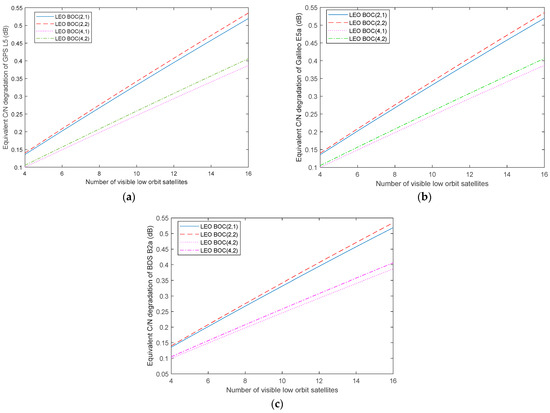
Figure 5.
Analysis results of the degradation of effective C/N0 at L5: (a) GPS L5, (b) Galileo E5a, and (c) BDS B2a.
5. Conclusions
Accelerating the convergence speed of the PPP algorithm is one of the most concerning aspects of LEO navigation augmentation systems, and it is also a development hotspot in the field of LEO navigation augmentation. LEO navigation augmentation requires broadcasting the dedicated LEO navigation augmentation signals to achieve the goal of real-time high-precision positioning services. This paper analyzes the design requirements of LEO navigation augmentation signals. On this basis, BOC (2,1), BOC (2,2), BOC (4,1), and BOC (4,2) are designed for the L1 and L5 frequency bands. The proposed signals consist of a high-precision measurement component and a data component with a high data rate, which were multiplexed into one composite signal using MCSK. Finally, from the perspective of the degradation of effective C/N0, compatibility between the proposed LEO navigation augmentation signals and GNSS signals is assessed. The results show that BOC (4,1) and BOC (4,2) have better compatibility, which can be considered the design of LEO navigation augmentation signals at L1 and L5.
Author Contributions
Conceptualization, T.Y. and Y.W.; formal analysis, T.Y. and L.B.; investigation, T.Y. and Y.W.; data curation, T.Y.; writing—original draft preparation, T.Y. and Y.W.; writing—review and editing, T.Y. and Y.M.; visualization, T.Y. All authors have read and agreed to the published version of the manuscript.
Funding
The research was funded through the Outstanding Youth Talent funding program of the China Academy of Space Technology (Xi’an) (grant number: Y23-RCFYJQ2-04).
Institutional Review Board Statement
Not applicable.
Informed Consent Statement
Not applicable.
Data Availability Statement
Data sharing is not applicable to this article.
Conflicts of Interest
Authors were employed by the company China Academy of Space Technology (Xi’an). The authors declare that this study received funding from China Academy of Space Technology (Xi’an). The funder was not involved in the study design, collection, analysis, interpretation of data, the writing of this article or the decision to submit it for publication.
References
- GNSS.asia. Market & Technology Trends, 2020—Edition 1; European Global Navigation Satellite Systems Agency: Prague, Czech Republic, 2020. [Google Scholar]
- Reid, T.G.R.; Chan, B.; Goel, A.; Gunning, K.; Manning, B.; Martin, J.; Neish, A.; Perkins, A.; Tarantino, P. Satellite Navigation for the Age of Autonomy. In Proceedings of the 2020 IEEE/ION Position, Location and Navigation Symposium (PLANS), Portland, OR, USA, 20–23 April 2020; pp. 342–352. [Google Scholar] [CrossRef]
- Prol, F.S.; Ferre, R.M.; Saleem, Z.; Välisuo, P.; Pinell, C.; Lohan, E.S.; Elsanhoury, M.; Elmusrati, M.; Islam, S.; Çelikbilek, K.; et al. Position, Navigation, and Timing (PNT) Through Low Earth Orbit (LEO) Satellites: A Survey on Current Status, Challenges, and Opportunities. IEEE Access 2022, 10, 83971–84002. [Google Scholar] [CrossRef]
- Ries, L.; Limon, M.C.; Grec, F.-C.; Anghileri, M.; Prieto-Cerdeira, R.; Abel, F.; Miguez, J.; Perello-Gisbert, J.V.; D’Addio, S.; Ioannidis, R.; et al. LEO-PNT for Augmenting Europe’s Space-based PNT Capabilities. In Proceedings of the 2023 IEEE/ION Position, Location and Navigation Symposium (PLANS), Monterey, CA, USA, 24–27 April 2023; pp. 329–337. [Google Scholar] [CrossRef]
- Reid, T.G.; Neish, A.M.; Walter, T.F.; Enge, P.K. Leveraging Commercial Broadband LEO Constellations for Navigating. In Proceedings of the 29th International Technical Meeting of the Satellite Division of The Institute of Navigation (ION GNSS+ 2016), Portland, OR, USA, 12–16 September 2016; pp. 2300–2314. [Google Scholar]
- Reid TG, R.; Neish, A.M.; Walter, T.; Enge, P.K. Broadband LEO Constellations for Navigation. J. Inst. Navig. 2018, 65, 205–220. [Google Scholar] [CrossRef]
- Li, X.; Ma, F.; Li, X.; Lv, H.; Bian, L.; Jiang, Z.; Zhang, X. LEO constellation-augmented multi-GNSS for rapid PPP convergence. J. Geod. 2019, 93, 749–764. [Google Scholar] [CrossRef]
- Hong, J.; Tu, R.; Zhang, P.; Zhang, R.; Han, J.; Fan, L.; Wang, S.; Lu, X. GNSS rapid precise point positioning enhanced by low Earth orbit satellites. Satell. Navig. 2023, 4, 11. [Google Scholar] [CrossRef]
- Satellite Time & Location Signals 1000 Times Stronger than GPS; Satelles White Paper 2019; Satelles: Washington, DC, USA, 2019.
- Iannucci, P.A.; Humphreys, T.E. Economical Fused LEO GNSS. In Proceedings of the 2020 IEEE/ION Position, Location and Navigation Symposium (PLANS), Portland, OR, USA, 20–23 April 2020; pp. 426–443. [Google Scholar] [CrossRef]
- Knight, R. NovAtel Receivers to Support New Xona Commercial LEO Constellation. InsideGNSS. 31 May 2022. Available online: https://insidegnss.com/novatel-receivers-to-support-new-xona-commercial-leo-constellation/ (accessed on 18 March 2024).
- Mu, X. CENTISPACE LEO Augmentation Navigation System Status. International Committee on GNSS, Workshop on Low Earth Orbit (LEO) PNT Systems. June 2023. Available online: https://www.unoosa.org/documents/pdf/icg/2023/ICG_WG-S_LEO-PNT_Workshop_June_2023/ICG_LEO-PNT_Workshop_2023_01.pdf (accessed on 10 January 2024).
- Li, W.; Yang, Q.; Du, X.; Li, M.; Zhao, Q.; Yang, L.; Qin, Y.; Chang, C.; Wang, Y.; Qin, G. LEO augmented precise point positioning using real observations from two CENTISPACE™ experimental satellites. GPS Solut. 2024, 28, 44. [Google Scholar] [CrossRef]
- Wang, L.; Chen, R.; Li, D.; Zhang, G.; Shen, X.; Yu, B.; Wu, C.; Xie, S.; Zhang, P.; Li, M.; et al. Initial Assessment of LEO based Navigation Signal Augmentation System from Luojia-1A Satellite. Sensors 2018, 18, 3919. [Google Scholar] [CrossRef] [PubMed]
- Wang, L.; Chen, R.; Li, D.; Yu, B.; Wu, C. Quality Assessment of the LEO Navigation Augmentation Signals from Luojia-1A Satellite. Geomat. Inf. Sci. Wuhan Univ. 2018, 43, 2191–2196. [Google Scholar]
- Wu, C.; Shu, Y.; Wang, G.; Li, S. Design and Performance Evaluation of Tianxiang-1 Navigation Enhancement Signal. Radio Eng. 2020, 50, 748–753. [Google Scholar]
- Yan, T.; Wang, Y.; Li, T.; Tian, Y.; Qu, B.; Bian, L. MCSK Signal for LEO Satellite Constellation Based Navigation Augmentation System. In Proceedings of the China Satellite Navigation Conference (CSNC 2024) Proceedings. CSNC 2024, Jinan, China, 22–24 May 2024; Yang, C., Xie, J., Eds.; Lecture Notes in Electrical Engineering. Springer: Singapore, 2024; Volume 1093. [Google Scholar] [CrossRef]
- Li, X.; Yan, T.; Bian, L.; Guo, X.; Meng, Y. Study of PNT Signal and Its Performance on LEO Communication Constellation. In Proceedings of the China Satellite Navigation Conference (CSNC 2022) Proceedings. CSNC 2022, Beijing, China, 22–25 May 2022; Yang, C., Xie, J., Eds.; Lecture Notes in Electrical Engineering. Springer: Singapore, 2022; Volume 909. [Google Scholar] [CrossRef]
- Sun, Q.; Liu, H.; Peng, F.; Chu, Y.; Bao, X.; Jiang, F.; Zhang, X. Research on co-frequency interference critera of low orbit satellite constellations to geostationary satellites. Space Electron. Technol. 2023, 20, 33–39. [Google Scholar]
- Zhang, J.; Xue, M. Research on performance analysis method of global satellite navigation system signal. Chin. Space Sci. Technol. 2015, 10–16. [Google Scholar] [CrossRef]
Disclaimer/Publisher’s Note: The statements, opinions and data contained in all publications are solely those of the individual author(s) and contributor(s) and not of MDPI and/or the editor(s). MDPI and/or the editor(s) disclaim responsibility for any injury to people or property resulting from any ideas, methods, instructions or products referred to in the content. |
© 2025 by the authors. Licensee MDPI, Basel, Switzerland. This article is an open access article distributed under the terms and conditions of the Creative Commons Attribution (CC BY) license (https://creativecommons.org/licenses/by/4.0/).