Multispectral Sensing and Data Integration for the Study of Heritage Architecture †


Abstract
:1. Introduction and Objectives
2. Materials and Methods
2.1. Methodology
2.2. Imagery Data
2.3. Multispectral Image Composition
2.4. Multispectral Orthophoto-Mosaic Composition
2.5. Raster Range Data
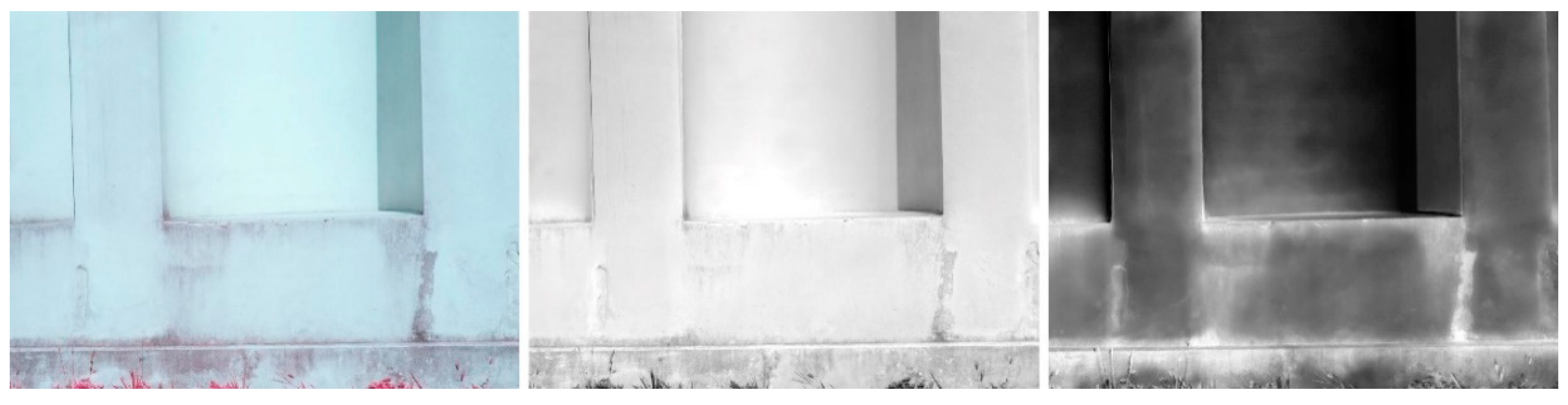
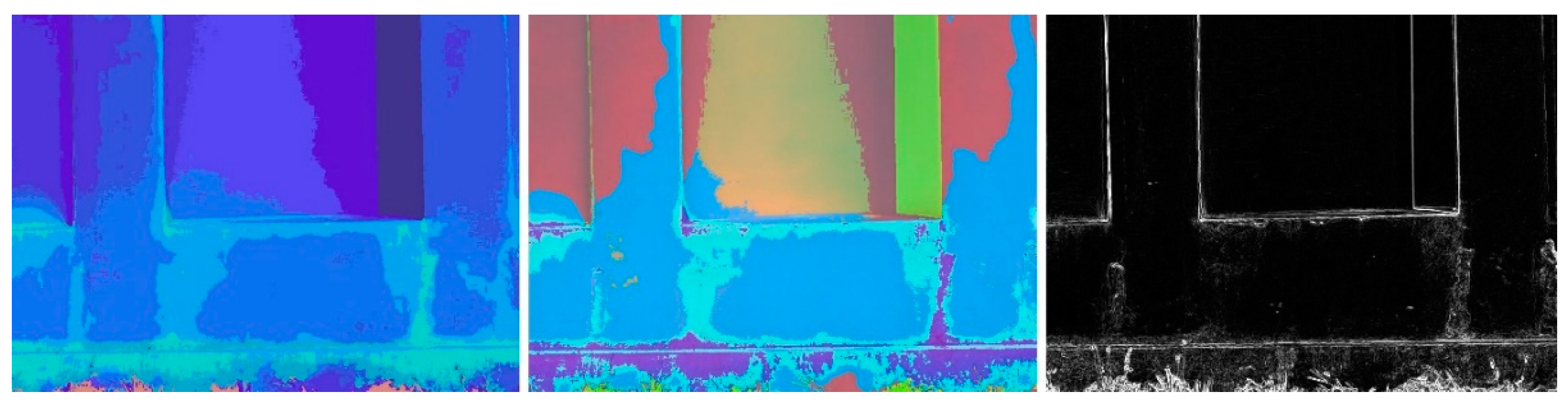
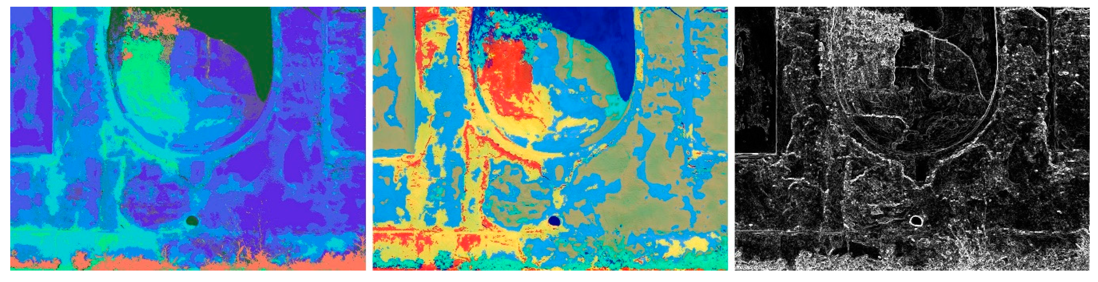
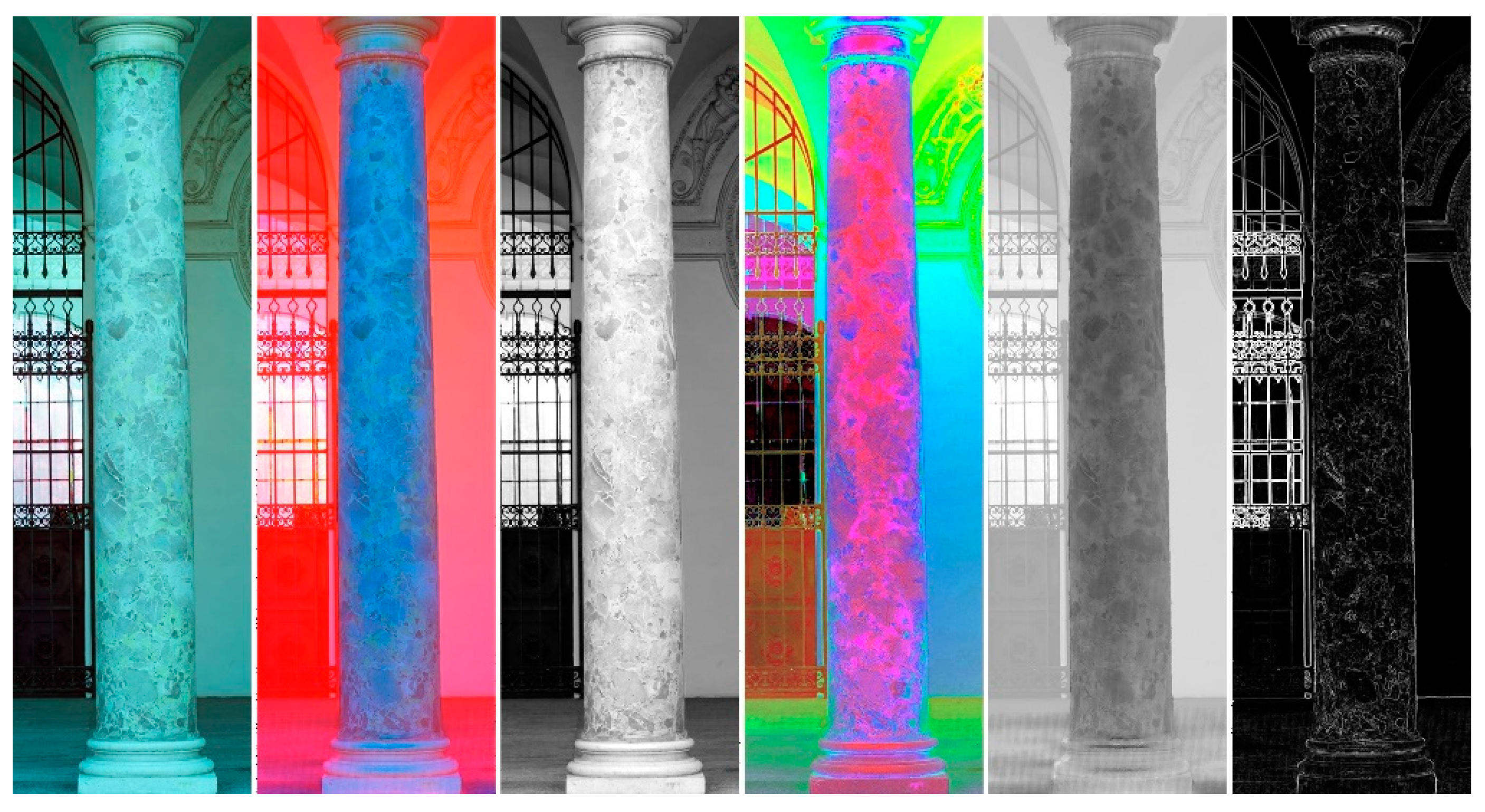
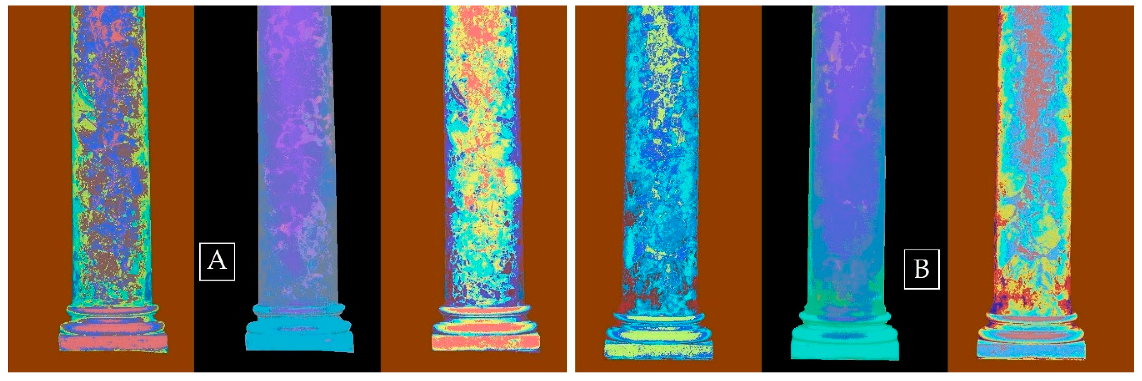
3. Results and Discussion
- Principal Component Analysis (PCA);
- Generation of pseudo-colored images using the five spectral bands and the calculated principal components (PCs);
- Generation of Color Quantized Images (CQIs);
- Unsupervised K-means, clustering-based image segmentation;
- Edge detection filtering.
4. Conclusions
Author Contributions
Funding
Conflicts of Interest
References
- Letellier, R.; Schmid, W.; LeBlanc, F. Recording, Documentation, and Information Management for the Conservation of Heritage Places: Guiding Principles; Getty Conservation Institute: Los Angeles, CA, USA, 2007; ISBN 978-0-89236-925-6. [Google Scholar]
- Rinaudo, F. Geomatics tools to record 3D shapes for intervention planning. In World Heritage and Disaster. Knowledge, Culture and Representation, Proceedings of the XVI International Forum ‘Le Vie dei Mercanti’, Naples, Italy, 15–17 June 2017; La Scuola di Pitagora: Naples, Italy, 2017; pp. 132–139. [Google Scholar]
- Kilic, G. Using advanced NDT for historic buildings: Towards an integrated multidisciplinary health assessment strategy. J. Cult. Herit. 2015, 16, 526–535. [Google Scholar] [CrossRef]
- Menéndez, B. Non-Destructive Techniques Applied to Monumental Stone Conservation. In Non-Destructive Testing; Garcia Marquez, F.P., Papaelias, M., Zaman, N., Eds.; InTech: Rijeka, Croatia, 2016; ISBN 978-953-51-2501-3. [Google Scholar]
- Lerma, J.L. Automatic Plotting of Architectural Facades with Multispectral Images. J. Surv. Eng. 2005, 131, 73–77. [Google Scholar] [CrossRef]
- Pozo, S.D.; Herrero-Pascual, J.; Felipe-García, B.; Hernández-López, D.; Rodríguez-Gonzálvez, P.; González-Aguilera, D. Multi-sensor radiometric study to detect pathologies in historical buildings. Int. Arch. Photogramm. Remote Sens. Spatial Inf. Sci. 2015, XL-5/W4, 193–200. [Google Scholar] [CrossRef]
- Kapsalas, P.; Maravelaki-Kalaitzaki, P.; Zervakis, M.; Delegou, E.T.; Moropoulou, A. Optical inspection for quantification of decay on stone surfaces. NDT E Int. 2007, 40, 2–11. [Google Scholar] [CrossRef]
- Sidiropoulou-Velidou, D.; Georgopoulos, A.; Lerma, J.L. Exploitation of Thermal Imagery for the Detection of Pathologies in Monuments. In Progress in Cultural Heritage Preservation; Ioannides, M., Fritsch, D., Leissner, J., Davies, R., Remondino, F., Caffo, R., Eds.; Lecture Notes in Computer Science; Springer: Berlin/Heidelberg, Germany, 2012; Volume 7616, pp. 97–108. ISBN 978-3-642-34233-2. [Google Scholar]
- Peña-Villasenín, S.; Gil-Docampo, M.; Ortiz-Sanz, J. 3-D Modeling of Historic Façades Using SFM Photogrammetry Metric Documentation of Different Building Types of a Historic Center. Int. J. Arch. Herit. 2017, 11, 871–890. [Google Scholar] [CrossRef]
- Adamopoulos, E.; Rinaudo, F. Enhancing Image-Based Multiscale Heritage Recording with Near-Infrared Data. IJGI 2020, 9, 269. [Google Scholar] [CrossRef]
- Suchocki, C.; Katzer, J.; Serrat, C.; Jagoda, M. Application of TLS Intensity Data for Detection of Brick Walls Defects. IOP Conf. Ser. Mater. Sci. Eng. 2019, 603, 022100. [Google Scholar] [CrossRef]
- Adamopoulos, E.; Tsilimantou, E.; Keramidas, V.; Apostolopoulou, M.; Karoglou, M.; Tapinaki, S.; Ioannidis, C.; Georgopoulos, A.; Moropoulou, A. Multi-Sensor Documentation of Metric and Qualitative Information of Historic Stone Structures. ISPRS Ann. Photogramm. Remote Sens. Spatial Inf. Sci. 2017, IV-2/W2, 1–8. [Google Scholar] [CrossRef]
- Adamopoulos, E.; Rinaudo, F. 3D Interpretation and Fusion of Multidisciplinary Data for Heritage Science: A Review. Int. Arch. Photogramm. Remote Sens. Spatial Inf. Sci. 2019, XLII-2/W15, 17–24. [Google Scholar] [CrossRef]
- Hemmleb, M.; Weritz, F.; Schiemenz, A.; Grote, A.; Maierhofer, C. Multi-spectral data acquisition and processing techniques for damage detection on building façades. Int. Arch. Photogramm. Remote Sens. Spatial Inf. Sci. 2006, XXXVI–B5. [Google Scholar]
- Lerma, J.L.; Cabrelles, M.; Akasheh, T.S.; Haddad, N.A. Documentation of Weathered Architectural Heritage with Visible, near Infrared, Thermal and Laser Scanning Data. Int. J. Herit. Dig. Era 2012, 1, 251–275. [Google Scholar] [CrossRef]


Publisher’s Note: MDPI stays neutral with regard to jurisdictional claims in published maps and institutional affiliations. |
© 2020 by the authors. Licensee MDPI, Basel, Switzerland. This article is an open access article distributed under the terms and conditions of the Creative Commons Attribution (CC BY) license (https://creativecommons.org/licenses/by/4.0/).
Share and Cite
Adamopoulos, E.; Rinaudo, F.; Volinia, M.; Girotto, M. Multispectral Sensing and Data Integration for the Study of Heritage Architecture. Eng. Proc. 2020, 2, 64. https://doi.org/10.3390/ecsa-7-08198
Adamopoulos E, Rinaudo F, Volinia M, Girotto M. Multispectral Sensing and Data Integration for the Study of Heritage Architecture. Engineering Proceedings. 2020; 2(1):64. https://doi.org/10.3390/ecsa-7-08198
Chicago/Turabian StyleAdamopoulos, Efstathios, Fulvio Rinaudo, Monica Volinia, and Mario Girotto. 2020. "Multispectral Sensing and Data Integration for the Study of Heritage Architecture" Engineering Proceedings 2, no. 1: 64. https://doi.org/10.3390/ecsa-7-08198
APA StyleAdamopoulos, E., Rinaudo, F., Volinia, M., & Girotto, M. (2020). Multispectral Sensing and Data Integration for the Study of Heritage Architecture. Engineering Proceedings, 2(1), 64. https://doi.org/10.3390/ecsa-7-08198