Abstract
This article provides an in-depth overview of mine gas emission monitoring practices in the Ostrava-Karviná Coalfield (OKR), one of the most significant regions in Central Europe affected by post-mining methane leakage. The study presents field measurement techniques, including atmogeochemical surveys, systematic methane screening in soil air, and surface emission rate monitoring using accumulation chambers. Over the course of several long-term projects, more than 43 km2 of land were surveyed, and risk classification maps were developed based on measured methane concentrations and surface release rates. These data support land-use planning, the design of degasification measures, and the verification of their effectiveness. Results confirm that methane emissions persist even decades after mine closures and vary depending on atmospheric pressure and local geological conditions. The OKR methodology was also compared to international practices in Poland, Canada, and China. The article concludes with future research directions focused on automation, integration of sensor networks, and predictive modeling of gas migration in post-mining environments.
1. Introduction
According to data from greenhouse gas monitoring evaluations within the European Union, coal mines represent the largest source of methane emissions in the energy sector. It is essential to continuously assess and manage methane emissions [1]. In 2019, direct methane emissions from the coal industry accounted for 31% of all methane emissions—nearly equivalent to the combined share from oil and fossil gas, which stood at 33%. Research indicates that methane emissions primarily originate from underground mining in active operations and from closed and abandoned coal mines. In active mines, methane is continuously monitored due to the health and safety risks it poses. In 2019, surface coal mines in the EU (European Union) emitted a total of 166 kilotonnes of methane, while underground coal mines released 828 kilotonnes into the atmosphere. Most of the methane from active underground coal mines escapes through ventilation and degasification systems [2], which are used to reduce in-mine gas concentrations.
Methane is the second most significant greenhouse gas after carbon dioxide in terms of its contribution to global climate change. It is estimated to be responsible for roughly one-third of current global warming. In the past decade, a significant acceleration in atmospheric methane concentrations has been observed. Despite its shorter atmospheric lifetime (9–12 years) compared to carbon dioxide, methane has over 80 times greater global warming potential over a 20-year horizon. Over a 100-year period, its warming effect is nearly 30 times greater than that of carbon dioxide, whereas over 20 years it reaches 82.5 times. Methane also contributes to the formation of ground-level ozone and exacerbates air pollution. If global methane emissions were reduced by 45% by 2030 through the implementation of available measures and additional actions, it could prevent a rise in global temperature of 0.3 °C by 2045.
2. Measurement of Mine Gas Emissions
The issue of mine gas emissions in the Ostrava region of the Ostrava-Karviná Coalfield (OKR), which had been addressed since the 1990s, was further developed by the project (“35/AKT—Comprehensive Solution to the Methane Issue in Relation to Abandoned Mine Workings.”) This project was funded by the Ministry of Finance of the Czech Republic and was carried out between 2010 and 2019. It was implemented by the consortium “Velký metan” in collaboration with several regional companies and the Faculty of Mining and Geology at VSB—Technical University of Ostrava. The aim of the project was to design and implement a system of technical measures to protect human health and property from widespread, uncontrolled surface emissions of mine gases. The main objective was to reduce the risk to the population posed by potential emergency events associated with methane leakage to the surface [3]. A key component of the project was an atmogeochemical survey, conducted between 2010 and 2016, which identified and mapped the main risk areas for surface mine gas emissions across a 43 km2 area. Field measurement teams conducted on-site investigations through gas sampling, using either injection probes or the so-called bell method. Sampling was carried out based on a predefined network. The survey results were compiled into a map-based dataset providing expert estimates of the risk levels associated with mine gas emissions at specific locations.
3. Atmogeochemical Survey
Atmogeochemistry [4] focuses on measuring the concentrations of methane (CH4) and carbon dioxide (CO2), which are the key components of the mine gas mixture present in soil air. Based on an approved methodology, measurement teams conducted systematic field investigations. Area-wide measurements were carried out using a grid of sampling points spaced 10 × 10 m in built-up areas and 15 × 15 m in non-urban areas. Samples were collected immediately after drilling shallow boreholes to a depth of 1.1 m in the soil, in accordance with accredited procedures.
At each sampling site, gas was extracted using a narrow probe inserted into the ground to a depth of approximately 1.1 m. In cases where soil conditions did not permit direct probe insertion, the bell method was applied, which involves collecting air samples directly above the ground surface. In locations where elevated concentrations of methane were detected in the soil air, supplementary measurements were conducted to assess the dynamics of methane migration toward the surface.
4. Methane Screening—Measurement of Mine Gas Components in Soil Air
Methane screening is a method for measuring the concentrations of methane and carbon dioxide in soil air. It is performed to locate their surface emissions [5], determine their concentrations, and to:
- Identify and refine the positions of old mine workings and associated underground voids;
- Verify the effectiveness of safety measures implemented after the remediation of abandoned mine sites;
- Address emergency situations associated with uncontrolled mine gas emissions;
- Detect point and diffuse mine gas releases, particularly within individual administrative units.
The application of methane screening is possible only under favorable climatic conditions and during suitable barometric pressure states and trends. Measurements cannot be conducted when soil gas permeability is significantly reduced—for example, due to excessive moisture, snow cover, or frozen ground. Mine gas concentration measurements are permitted only when sea-level corrected barometric pressure reaches 1017 hPa or lower, and the pressure is either decreasing or increasing only slightly—by no more than 3 hPa over a three-hour period.
An exception applies in cases where barometric pressure exceeds 1017 hPa but has decreased by more than 5 hPa over the previous 24 h and continues to decline or has stabilized. If pressure stabilization occurs after a prior drop, measurements are allowed within a 24 h window from the onset of stabilization.
Atmospheric pressure is a critical factor in methane screening measurements [6,7,8]. As illustrated in Figure 1 and Figure 2, methane screening was conducted in the selected area DŮC 30.2z under atmospheric pressure conditions of 1002 hPa. Following an increase in pressure to 1027 hPa, measurements were repeated using the same method and in the same area. The difference in pressure significantly affects the measurement results.
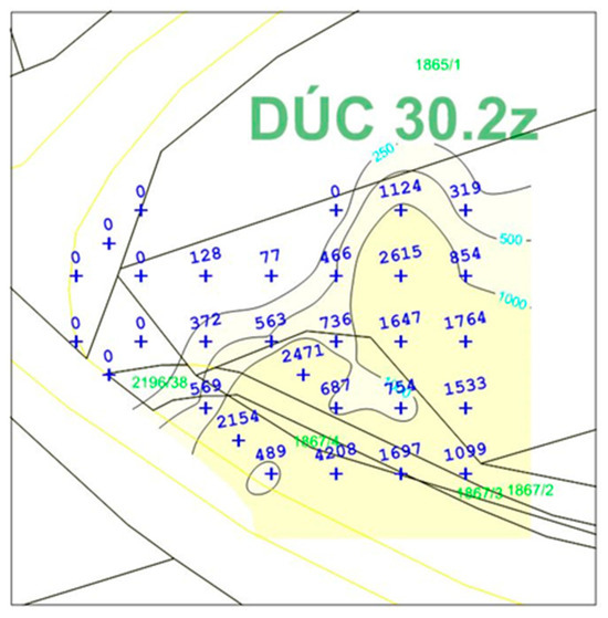
Figure 1.
Methane Screening at 1002 hPa Atmospheric Pressure.
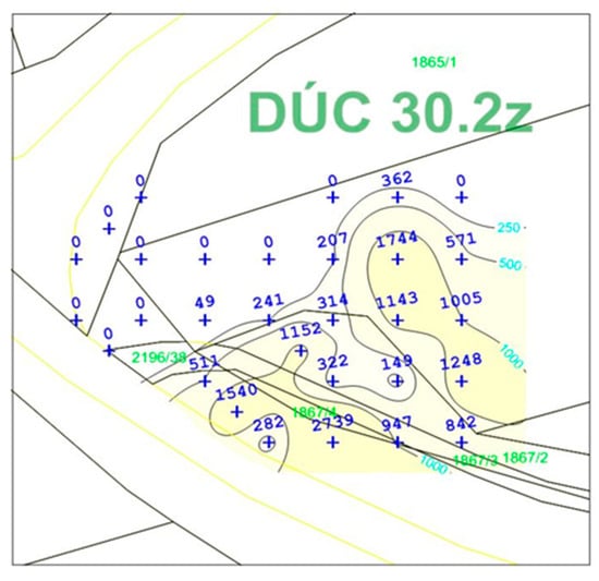
Figure 2.
Methane Screening at 1027 hPa Atmospheric Pressure.
Climatic conditions must remain within the operational limits defined for the safe use of all equipment and measuring instruments. To obtain the most comprehensive information on uncontrolled surface emissions of mine gases, it is essential to measure the concentrations of both methane and carbon dioxide simultaneously. For this reason, within the given methodology, methane screening is understood as the measurement of both key mine gas components.
Using a properly inserted probe, soil air is drawn into a portable gas analyzer (RS DYNAMICS, Hørsholm, Denmark), which determines the concentrations of the target gases and stores the results in its internal memory. Upon completion of the measurement, the data are exported to dedicated software applications, where the recorded values are further evaluated. The following Figure 3. illustrates the scheme of the measuring apparatus.
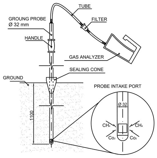
Figure 3.
Methane Screening—Description of the Measuring Apparatus.
Land classification based on the risk of mine gas emissions is determined according to the highest measured concentrations of methane in soil air, following the rules below:
- Category A—No risk: Land where methane concentrations in the measurement set ranged from 0 to 0.5%;
- Category B—Low risk: Land where methane concentrations exceeded 0.5%, but did not exceed 1%;
- Category C—Medium risk: Land where methane concentrations exceeded 1%, but did not exceed 4.5%;
- Category D—High risk: Land where measured methane concentrations exceeded 4.5%.
As part of methane screening, a baseline methane screening (BMS) is conducted, serving as the foundation for the design of specific methane mitigation measures (such as degasification boreholes or other degasification elements [9]. After the implementation of these mitigation measures, it is necessary to verify their effectiveness. The control methane screening (CMS), performed on areas where the BMS recorded methane concentrations exceeding 300 ppm, provides the decisive data for this verification.
An example of the graphical evaluation of the baseline and subsequent control methane screening, following the installation of a degasification borehole [10], is illustrated in Figure 4 and Figure 5.
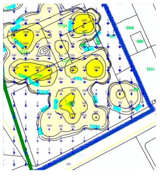
Figure 4.
Map Section (BMS).
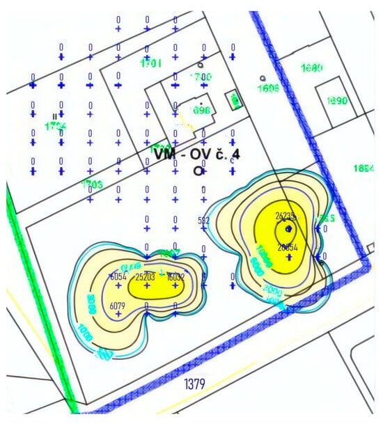
Figure 5.
Map Section (CMS).
5. Measurement of Methane Emission Dynamics at the Surface
The method for measuring the dynamics of methane emissions at the surface is, alongside methane screening (which focuses on methane concentrations in soil air), an additional technique used to confirm or rule out the existence and quality of gas migration pathways between mined-out voids and the surface. This issue is not unique to the Czech Republic; it is also being addressed in other countries, as demonstrated by studies from Canada [11], China [12,13], and Poland [14]. This method complements the information obtained through methane screening by providing a crucial additional parameter—the volumetric rate of methane emission to the surface over a defined area and time period. Standardized processing and evaluation of the measurement data, including the application of the obtained results, offer essential insights for assessing the level of risk associated with mine gas emissions to the surface and for determining appropriate safety measures.
The method for measuring the dynamics of gas mixture emissions to the surface can be applied in complex urban environments and densely built-up areas with extensive underground utility networks, where conventional methane screening is not feasible. In such cases, it serves as a primary source of information.
The method is based on the near-hermetic sealing of a 0.25 m2 surface area using an accumulation chamber, without significantly disturbing the surrounding environment. Gases migrating from the covered surface accumulate in the enclosed atmosphere of the chamber, which initially contains ambient air free of methane—the target compound being measured. A progressive increase in the average methane concentration within the chamber is then observed. During the initial phase after the chamber is installed, this increase is almost proportional to time and can be approximated by a linear function of concentration versus time. This property allows the system to perform continuous sampling of the gas mixture inside the chamber. The gas mixture is transported via connecting tubes to a high-sensitivity gas analyzer, and then recirculated back into the accumulation chamber, creating a closed-loop gas circulation system.
The transport of the gas mixture from the accumulation chamber to the analyzer, the sample analysis, and the return of the gas back into the chamber are all ensured by the built-in pump of the analyzer. Inside the accumulation chamber, a fan powered by an external source is mounted on the upper wall to facilitate internal air circulation. The accumulation chamber is equipped with two ports for connecting the tubing and is sealed along its edge with a gasket. The internal dimensions of the chamber are approximately 50 × 50 cm, with a height of 15 cm. The principle of methane emission measurement is shown in the following Figure 6.
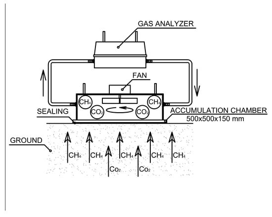
Figure 6.
Schematic Representation of Surface Methane Emission Dynamics Measurement.
For the actual measurement, it is necessary to use portable gas analyzers equipped with built-in sampling and return flow systems (i.e., recirculation of the analyzed gas), ensuring that the chemical and physical properties of the recirculated gas remain unchanged. The analyzer must have a measurement range of at least 0–10,000 ppm. The most suitable instruments for measuring the dynamics of mine gas emissions are gas detectors that do not consume the sample gas, do not alter its properties, and operate on the principle of laser spectroscopy. Other suitable devices include infrared analyzers (Crowcon Detection Instruments Ltd., Milton Park, Abingdon, United Kingdom) with a sensitivity of 1 ppm, equipped with an integrated pump to enable gas circulation.
To assess the risk of methane emissions on a given site, the previously described methods are employed—methane concentration measurements in soil (methane screening) and surface methane flux measurements (methane emission dynamics). These two methods are complementary in terms of data interpretation and evaluation.
Land classification based on the risk of mine gas emissions, according to the highest measured values of methane emission flux to the surface, is determined as follows:
- Category “No Risk” Land where the measured methane emission flux to the surface is below 5 cm3·m−2·min−1;
- Category “Level 1 Risk” Land where the measured methane emission flux to the surface is equal to or greater than 5 cm3·m−2·min−1, but less than 10 cm3·m−2·min−1;
- Category “Level 2 Risk” Land where the measured methane emission flux to the surface is equal to or greater than 10 cm3·m−2·min−1, but does not exceed 20 cm3·m−2·min−1;
- Category “Level 3 Risk” Land where the measured methane emission flux to the surface is equal to or greater than 20 cm3·m−2·min−1.
Based on the degree of mine gas emission hazard, the land parcel is classified into a risk category following measurement and evaluation of reference threshold values.
International research shows that similar measurement approaches are applied in countries such as Poland, Canada, and China. For example, in Polish coal basins, similar accumulation chambers with laser analyzers are used for methane emission measurements. In Canada, continuous atmospheric monitoring using mobile laboratories is more commonly applied. Compared to these approaches, the method used in the Ostrava-Karviná Region (OKR) provides sufficient sensitivity for detecting point-source emissions and is adapted to the region’s dense urban development. For a more precise comparison, future research will propose a table comparing methane emission rates in cm3·m−2·min−1 across different regions [15].
6. Map of Risk Categorization in the Ostrava-Karviná Coalfield (OKR)
The map of risk categorization in the Ostrava-Karviná Coalfield (OKR) serves as a professional tool for visualizing the spatial distribution of potential surface mine gas emission hazards. It is based on the results of extensive atmogeochemical surveys and field measurements of methane concentrations and emission dynamics, carried out primarily within the framework of projects commissioned by the Czech Mining Authority (e.g., Project No. 1/99) and Project 35/AKT.
The land categorization is based on the determination of reference threshold values that reflect the level of methane emission risk. Based on a combination of methane concentration in soil air (methane screening) and the intensity of its flux (emission dynamics measurement), areas are divided into four risk categories. This approach enables a comprehensive environmental assessment and is primarily used to support decision-making processes in spatial planning, construction permitting, and the implementation of remediation measures.
The risk categorization map serves as a supporting tool for:
- Identifying high-risk areas affected by uncontrolled mine gas emissions;
- Designing and verifying the effectiveness of degasification measures;
- Planning infrastructure and construction projects in areas with a history of mining activity;
- Informing public authorities and building offices about the level of risk in specific zones.
This map in Figure 7 is regularly updated by the state-owned enterprise DIAMO, branch plant Karviná, which also serves as the data administrator and provider. The current version of the map is publicly available on the official website of DIAMO, s.p.
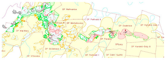
Figure 7.
Risk Categorization Map of the Ostrava-Karviná Coalfield [16] (red—areas with confirmed surface methane emissions; pink—areas with potentially hazardous methane emissions; gray—Carboniferous window; green—areas at risk of methane emissions; other colors—no identified risk).
7. Conclusions
The issue of uncontrolled mine gas emissions, particularly methane, from abandoned and decommissioned mine workings represents a significant safety and environmental risk that requires systematic monitoring, assessment, and management. Research conducted in the Ostrava-Karviná Coalfield confirms that even after mining operations have ceased, methane remains active within the rock mass and may continue to migrate toward the surface.
As part of the described projects, a methodology for area-wide measurement of methane concentrations in soil air (methane screening) was successfully applied and complemented by surface gas emission dynamics measurements using accumulation chambers. These approaches enabled the identification of high-risk locations and the quantification of risk levels through land categorization.
The measurement results highlight the critical importance of climatic conditions, particularly barometric pressure, for the correct interpretation of data. It has been shown that proper timing of measurements has a direct impact on their informative value and the subsequent decision-making processes.
From a long-term perspective, it is desirable to further develop the automation of monitoring systems, integrate data from various sources (e.g., sensor networks, atmospheric models), and design predictive models of gas behavior in the subsurface environment. An additional step should be the establishment of legislative and methodological support for a standardized assessment of mine gas emission risks at the national level.
Future Research Perspectives:
- Development of predictive models based on a combination of geochemical data, atmospheric parameters, and historical mining information.
- Deployment of unmanned aerial systems (UAS) and automated sensor networks for long-term, unattended monitoring of emissions.
- Assessment of the influence of barometric fluctuations and climatic trends on the intensity of mine gas emissions.
- International comparison of methodologies and approaches among European regions with similar geological and mining histories.
Author Contributions
Conceptualization, V.K. and P.M.; methodology, V.K. and J.V.; software, D.G.; validation, V.K., P.M. and P.K.; formal analysis, J.V.; investigation, D.S. and A.S.; resources, P.K.; data curation, A.S.; writing—original draft preparation, V.K.; writing—review and editing, P.M. and J.V.; visualization, D.G.; supervision, V.K.; project administration, V.K.; funding acquisition, V.K. All authors have read and agreed to the published version of the manuscript.
Funding
This research received no external funding. The APC was funded by the Department of Mining Engineering and Safety, VSB—Technical University of Ostrava.
Institutional Review Board Statement
Not applicable.
Informed Consent Statement
Not applicable.
Data Availability Statement
The data presented in this study are available on request from the corresponding author due to confidentiality restrictions.
Conflicts of Interest
The authors declare no conflicts of interest.
References
- Patyńska, R. Methodology of Estimation of Methane Emissions from Coal Mines in Poland. Stud. Geotech. Mech. 2014, 36, 89–101. [Google Scholar] [CrossRef]
- Prokop, P.; Zapletal, P.; Pěgřimek, I. Prognosis of Residual Coal Gas Capacity Made by the ‘Express’ Method. Int. J. Miner. Metall. Mater. 2011, 18, 127–131. [Google Scholar] [CrossRef]
- Koudelková, J.; Beňová, E. Risk Assessment from the Output of Mine Gases. In 12th International Multidisciplinary Scientific GeoConference SGEM 2012: Conference Proceedings, Volume I–V; STEF92 Technology Ltd.: Sofia, Bulgaria, 2012; pp. 785–790. [Google Scholar]
- Najmanová, P.; Nyplová, P.; Kubal, M.; Janků, J. Application of Quantitative Atmogeochemistry in Monitoring Old Ecological Burdens. Chem. Listy 2006, 100. Available online: http://w.chemicke-listy.cz/ojs3/index.php/chemicke-listy/article/view/1878 (accessed on 22 July 2025).
- Chae, G.; Kim, C.Y.; Ju, G.; Park, K.G.; Roh, Y.; Lee, C.; Yum, B.; Kim, G. Soil CO2 Monitoring Around Wells Discharging Methane. Econ. Environ. Geol. 2022, 55, 407–419. [Google Scholar] [CrossRef]
- Levin, I.; Glatzel-Mattheier, H.; Marik, T.; Cuntz, M.; Schmidt, M.; Worthy, D. Verification of German Methane Emissions Inventories and Their Recent Changes Based on Atmospheric Observations. J. Geophys. Res. Atmos. 1999, 104, 3447–3456. [Google Scholar] [CrossRef]
- Wu, T.; Zhan, L. Influence of Atmospheric Pressure on Methane Emissions from Earthen Landfill Covers. In Environmental Science and Engineering, Proceedings of the 8th International Congress on Environmental Geotechnics, Hangzhou, China, 28 October–1 November 2018; Springer: Singapore, 2018; Volume 2, pp. 85–92. [Google Scholar]
- Zapletal, P.; Pach, G.; Kosowski, M. The Influence of Atmospheric Pressure on Methane Drainage from Mines in the Upper Silesian Coal Basin. Int. J. Oil Gas Coal Technol. 2022, 30, 97–108. [Google Scholar] [CrossRef]
- Hudeček, V.; Zapletal, P.; Zubíček, V. The Protection against Methane Leakage from Undermined Areas. [Online]. 2015. Available online: http://hdl.handle.net/10084/125198 (accessed on 2 July 2025).
- Mokrošová, A.; Prokop, P.; Zapletal, P.; Kráľ, T.; Rudický, R. Ways to Protect Surface and Surface Objects from Uncontrollable Leakage of Mine Gas to the Surface. In 16th International Multidisciplinary Scientific GeoConference SGEM 2016: Science and Technologies in Geology, Exploration and Mining: Conference Proceedings, Volume II; STEF92 Technology Ltd.: Sofia, Bulgaria, 2016; pp. 1009–1014. ISBN 978-619-7105-56-8. [Google Scholar]
- Williams, J.; Risk, D.; Marshall, A.; Nickerson, N.; Martell, A.; Creelman, C.; Grace, M.; Wach, G. Methane Emissions from Abandoned Coal and Oil and Gas Developments in New Brunswick and Nova Scotia. Environ. Monit. Assess. 2019, 191, 479. [Google Scholar] [CrossRef] [PubMed]
- Liang, Y.; Li, Z.; Zhu, S.; Chen, Q.; Wang, X.; Qin, C. Research Status and Reduction Strategies of Methane Emissions from Closed/Abandoned Coal Mines. J. China Coal Soc. 2023, 48, 1645–1660. [Google Scholar]
- Zhang, X.; Zhu, T.; Yi, N.; Yuan, B.; Li, C.; Ye, Z.; Zhu, Z.; Zhang, X. Study on Characteristics and Model Prediction of Methane Emissions in Coal Mines: A Case Study of Shanxi Province, China. Atmosphere 2023, 14, 1422. [Google Scholar] [CrossRef]
- Sechman, H.; Kotarba, M.; Kędzior, S.; Kochman, A.; Twaróg, A. Fluctuations in Methane and Carbon Dioxide Concentrations in the Near-Surface Zone and Their Genetic Characterization in Abandoned and Active Coal Mines in the SW Part of the Upper Silesian Coal Basin, Poland. Int. J. Coal Geol. 2020, 227, 103529. [Google Scholar] [CrossRef]
- Borowski, M.; Zwolińska-Glądys, K.; Cheng, J. Methane Emissions from Coal Mines: Quantification, Capture, and Utilization Strategies for Atmospheric Impact Mitigation—A Case Study from Poland. Atmosphere 2025, 16, 174. [Google Scholar] [CrossRef]
- DIAMO, state-owned enterprise, branch Karviná. Mapa kategorizace území OKR 2024. [Online]. 2024. Available online: https://www.diamo.cz/storage/app/media/dokumenty/ODRA/Mapa%20kategorizace%202024-web.pdf (accessed on 22 July 2025).


Disclaimer/Publisher’s Note: The statements, opinions and data contained in all publications are solely those of the individual author(s) and contributor(s) and not of MDPI and/or the editor(s). MDPI and/or the editor(s) disclaim responsibility for any injury to people or property resulting from any ideas, methods, instructions or products referred to in the content. |
© 2026 by the authors. Licensee MDPI, Basel, Switzerland. This article is an open access article distributed under the terms and conditions of the Creative Commons Attribution (CC BY) license.