Abstract
Romania’s wooden churches, numbering over 1400, represent a unique and valuable cultural heritage. However, their preservation faces challenges due to degradation and insufficient documentation regarding their condition and significance. This paper presents innovative approaches to documenting these monuments using two representative online platforms. The “Biserici Înlemnite” platform focuses on inventorying wooden churches through a systematic methodology, while the 3D-VIMM platform provides a multimodal imaging and 3D data visualization solution aimed at creating digital twins for heritage assets. Advanced technologies, such as 3D digitization and Historical Building Information Modeling (H-BIM), enhance accessibility and precision in conservation planning. While H-BIM traditionally requires complex workflows, the 3D-VIMM platform simplifies the process by integrating diverse imaging techniques—visible, thermal, multispectral—and metadata within an intuitive interface. This enables interdisciplinary collaboration among historians, architects, conservators, and engineers. A case study from Arad County illustrates a possible path to the integration of these platforms, highlighting their potential to optimize data collection, prioritize interventions, and support long-term preservation strategies. The article underscores the importance of transdisciplinary methodologies in addressing the critical state of Romania’s wooden churches and provides insights into scalable solutions for heritage documentation and conservation.
1. Introduction
The wooden churches in Romania, although still in large numbers (widely approximated somewhere between 1400 and 2000) are facing several problems that will eventually lead to their disappearance at an alarming rate. One of the most serious current problems is that the exact number of existing historic wooden churches, their state of conservation, and their value are unknown. Various approximations have been made regarding the actual number of these wooden churches, based on the Historical Monuments List (Lista Monumentelor Istorice) and other local bibliographic references that include such structures that are not part of the official Historical Monuments List. Although most compilation books on wooden churches in Romania and articles are rather descriptive and outdated, they still provide us with insightful information about the numbers and typologies. Most notably, for the region of Moldova, Ichim authored several books on the subject covering the whole historical region [1], Bacău County [2], Neamţ County [3], the regions of Bukovina and Bessarabia [4], and lately, a journalistic approach by Bălinişteanu appeared to encompass a lot of such wooden churches in Moldova [5]. The rest of the country has been covered for decades by the many studies of Cristache-Panait, mentioning, amongst others, Argeş County [6], Hunedoara County [7], Gorj County [8], and Arad County [9]. In a more recent study, Zamora covered a series of wooden churches from the mountainous region of Oltenia [10]. Our understanding regarding the continuous loss of churches would not be possible without the studies of Petranu for the western part of the country [11], Bata et al. 2023 for the valorization of the Szinte brothers’ pre-war photography archive of wooden churches from the northern Transylvania [12] and, lastly, Baboş’ work on the region of Maramureş [13]. Baboş dedicated several papers to the research of wooden churches, employing both classical research and dendrochronology; the one we exemplify is just his PhD thesis. The bibliography used to calculate the numbers extends much beyond these names and means, but these papers played a pivotal role in understanding the shortcomings of previous research and also served as a solid starting point for the inquest.
Inventorying wooden churches in Romania was first approached by specialists in the early sixties of the previous century and it focused on a small region in the Mureş County [14], as part of the fieldwork imposed by the Historical Monuments Directorate at the time, but it never extended beyond that. The broadest attempt to inventory churches of all confessions and building materials, monuments or not, was started by Losonczy in 2005, and it has been expanded with the help of a team of volunteers for the past few years [15].
The neglect of wooden architecture, depopulation of rural areas, abandonment, the low financial strength of communities [16], together with the steady disappearance of craftsmen [17], the poor training of the conservation-restoration specialists, and the near lack of public policies to safeguard this type of heritage are all factors that contribute greatly to the accelerated loss of wooden churches.
The general public, owners, and some of the specialists see wooden architecture as a characteristic of poverty and lack of social status [18]. The detachment of the community leads to the construction of new buildings, sometimes clumsily replicating the original church’s volumetry (see references to Şuvăială), at best next to the historic structure, sometimes replacing it altogether. The process of adapting churches to the community’s needs is not a new one, with historic wooden churches often having had a series of more or less documented stages of intervention. However, the historical alterations, carried out until the second quarter of the last century, cared for the quality of the materials used and did not break with traditional craftsmanship, although some of them were rather innovative.
In the last century, however, the departure from traditional techniques and practices, accompanied by the movement of the population towards urban areas and the desire for modernization, has created a bleak context. The wooden heritage is increasingly difficult to maintain due to the lack of craftsmen and powerful communities to protect it [17,18]. The conservation problems derived from the aforementioned context materialize in the form of specific degradation of the building material, which is strongly influenced by environmental factors, as well as by non-conformist interventions, without proper craftsmen or documentation. Most of the time, the scientific data relating to these wooden buildings are scarce and sometimes even erroneous, the communities have largely lost touch with the craft, and although this type of construction forms a large part of Romania’s cultural heritage, the exact data on their history, the craft used, the places where they were first built, the schools of painters who contributed to their decoration, the sense of their position in the general landscape, and their functionality and the practices associated with these places are often unknown. Detailed research on wooden churches is, in this context, necessary to safeguard and properly value them.
In this context, an online platform dedicated and adapted to the ever-evolving inventory methodology was mandatory. Besides the scientific intrinsic value of the data collected in the database (available at: https://biserici-inlemnite.ro/app [accessed on 6 March 2025]), a major objective of this process and instrument is to precisely determine the state of conservation and the value of the monuments. This is achieved by applying a set of defined principles that lead to a prioritization of the immediate needed actions, actions under the responsibility of the involved actors (owners, The National Institute of Heritage (Institutul Naţional al Patrimoniului) [19], and other related public institutions or important NGO-driven projects such as “Ambulanța pentru Monumente” (The Ambulance for Monuments) [20]), who can now draw up conservation strategies at the local, regional, or national level.
While this instrument was developed as a digital humanities tool to centralize, analyze, and share data about the wooden churches, 3D-VIMM (https://3d-vimm.luthonium.com [accessed on 6 March 2025]) was designed as a 3D and scientific multi-modal imaging data visualization tool and repository for 3D digitized heritage buildings [21]. With an intuitive UI, users can examine a heritage building in 3D, with the platform offering options for the investigated areas of interest and the types of image data available. Thus, the same user can choose between visible-type visualization (displaying natural color), thermal imaging, multispectral imaging (ultraviolet or near-infrared), laser Doppler vibrometry, or any other type of imaging investigation. Additionally, 3D-VIMM supports advanced functionalities such as mapping humidity measurements on the monument’s surface, overlaying physicochemical investigation results (e.g., LIBS, FTIR, and XRF) with corresponding spectral data hotspots on the 3D model, and integrating data from microclimate sensors. This comprehensive approach allows an enriched understanding of the monument’s condition and environment, fostering better conservation and restoration strategies.
The use of multimodal imaging and interactive 3D repositories is not a novel concept [22,23,24]; however, the 3D-VIMM project takes a significant step forward by advancing toward the digital twin paradigm for heritage monuments. By utilizing 3D digitized and optimized meshes, instead of simplified models, 3D-VIMM enhances the realism and functionality of virtual representations, providing a more immersive and practical tool for heritage documentation and analysis.
2. Materials and Methods
This section provides a detailed description of the methodologies and technical approaches employed in the development and implementation of the two online platforms: the wooden church inventory database (https://biserici-inlemnite.ro/app [accessed on 6 March 2025) and the 3D-VIMM repository (https://3d-vimm.luthonium.com [accessed on 6 March 2025]). It outlines the data collection methodology, data processing, and visualization methods used, as well as the software, tools, and workflows that underpin each platform.
2.1. Inventorying Online Platform “Biserici Înlemnite” (Transl.: Wooden Churches)
The inventorying project was started with the support of the Vernacular Cultural Association and funded in the first year (2021—Arad) by the AFCN (Administration of the National Cultural Fund) and will be continued on its own in the next two years (2022—Iași and 2023—Gorj) and funded by OAR (The National Order of Architects in Romania) through the Architecture Stamp. Each year, the partners of the project were the National Institute of Heritage, the County Cultural Directorates (Arad, Iași, Gorj), the Archbishoprics under whose jurisdiction the evaluated churches are located, the Faculty of Architecture of Timișoara, the National Museum of Banat, Trinitas TV, the Arad Museum Complex, the County Cultural Center of Arad, the Ethnographic Museum of Moldova within the National Museum Complex “Moldova” in Iași, and associations such as Pro Patrimonio and Inima Olteniei.
The beneficiaries of the platform are the actors involved in the management of the wooden cultural heritage (owners, Ministry of Culture, involved NGOs, local communities), specialists interested in the collected data, and the general public.
The inventorying process of wooden churches was designed as a multidisciplinary, visual, and preliminary assessment. A methodology was developed to make a professional assessment in the shortest possible time to reach the goal of 1400+ wooden churches in Romania within a tangible timeframe. The data collected for each wooden church can be divided into the following:
- General identification data;
- Data of scientific interest related to history, landscape, architecture, and artistic components;
- State of conservation;
- Value.
Given that the assessment of a wooden church is visual (no destructive or semi-destructive methods, e.g., surveys) and that it is carried out in a single day, the level of detail is preliminary and the data collected cannot be considered exhaustive and cannot replace the detailed multidisciplinary studies necessary for a conservation/restoration project.
The “Biserici Înlemnite” online platform is used to centralize and display, as clearly and as accessibly as possible, the scientific data collected in the field and the observations regarding the state of conservation of the church in general, respectively, the various architectural sub-assemblies, the artistic and landscape components in particular, and the observations related to the values of the church.
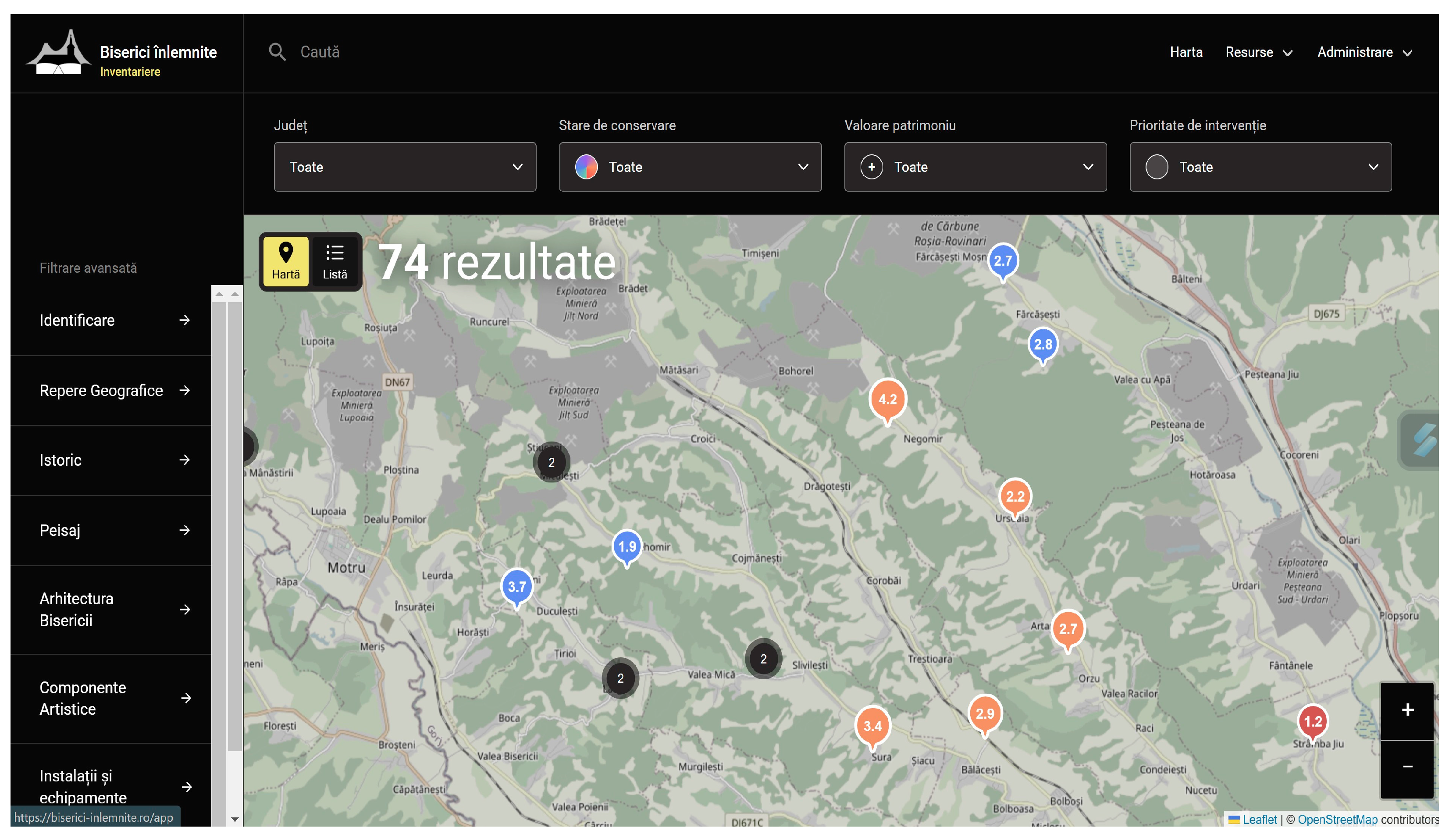
The visualization of the content can be carried out either in the form of a map (see Figure 1)—with pins having colors related to the state of conservation and numbers related to its value—or in the form of a list, whose columns cover the name, location, dating, state of conservation, value, and prioritization. Based on the scores obtained from the state of conservation and value assessment, an algorithm was developed to rank the wooden churches (in order of conservation or value issues or taken together) and to prioritize the necessary conservation/restoration actions, enhancement, and responsible advertising.
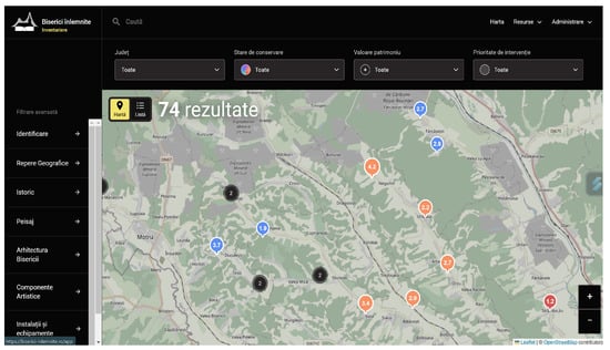
Figure 1.
Screen capture with the Wooden Churches platform interactive map.
The criteria to assess the state of conservation and the values of the churches are based on the legal inventory methodological norms in Romania, but they were developed more by the team to be particular for wooden constructions. For the state of conservation, marks are given from 1 (state of collapse) to 5 (very good state of preservation) for each structure or element. The state of preservation of the landscape, the state of preservation of the annexes and elements of the ensemble, the structure of the church, the roof, the artistic components, the furniture, etc., are analyzed. An average is made from all these grades. There is also a “danger” checkbox where the overall condition of the assembly may be good, but only a certain component is in poor condition and because of it, the whole assembly may be affected. For example, a cover through which water infiltrates can have devastating effects in a short time even if at the time of the analysis of the condition of the structure and its components, the state of preservation was good. If this button is checked, the priority of the church increases automatically. A total arithmetic mean of all these marks is made.
For values, many criteria are considered: age, architectural value, painting, craft, landscape, intangible heritage value, use value, accessibility value, relevance to the community, etc. The analysis of each criterion goes through the filters of integrity and authenticity. Here too, grades are given from 1 (where the value is almost non-existent) to 5 (where the value is exceptional).
These two grades are added together, and the church’s level of prioritization emerges. For example, a church with very high values and an average state of conservation will be prioritized for intervention compared to a church with average values but with a poor state of conservation. A church with a medium or good state of conservation, with high values, but where the “danger” marker appears, will be prioritized before the others. There are other details such as whether certain studies are necessary for a church such as dendrochronology, the study of the technique of a very valuable painting, or biological studies if there are fungal problems; all these are marked so that other researchers can know where there are problems or where there are areas of interest for in-depth research.
Each column in the list (name, location, dating, state of conservation, value, and prioritization) can be activated to display the data in ascending or descending order. From both visualization variants, detailed church files can be accessed, containing general data for the general public and detailed information for users with an account (reader/viewer role).
The portal also provides a multiple filtering system, through which registered users can visualize the churches by applying the criteria chosen from the predefined set of characteristics on each chapter of the file. The platform also offers the possibility to visualize specific hazards that threaten wooden churches on a case-by-case basis. Thus, they can be addressed in a timely and prioritized manner.
Key features of the “Biserici Înlemnite” platform:
- Browser-Based Access: Seamless usability via any web browser without requiring plug-ins or third-party applications.
- Search made easy: At the top of the website is the “Search” option, where one can type in the county, town, or name of the church. Another search option is also possible, via drop-down: single choice options, depending on the state of preservation, value, or prioritization of the church.
- Results filter system: The results can be filtered by applying predefined characteristics for each chapter in the file. Thus, one may have results displaying objectives that meet particularities related to age, structure, technique, artistic components, etc.
- Different user roles: Depending on their role, users can be editors (those who enter data about the church using their accounts), administrators (project coordinators with extended permissions on their accounts), active (users with an account who simply want to view the complete data) and users without an account (who can only view general information).
- Interactive map and list: The main interface of the platform is represented by an interactive map, with colored pins and a number referring to the graded state of preservation and value. Churches can also be visualized as an interactive table with columns for age, state of preservation, value, and prioritization. They can be sorted in ascending or descending order according to these criteria.
- Data upload process—online/offline: The team of editors can upload data (feature selection, text, images) directly on site, via large-screen gadgets (laptop, tablet), regardless of the device being connected to the internet or not; the data will be synchronized whenever a connection to the internet becomes available.
- Versatility of the inventory sheet: Editors can fill in the sheet within multiple stages and with varying degrees of complexity, from strictly selecting predefined features through the fields of each subdivision to describing them further and uploading photos with or without additional descriptions.
- Easy navigation: The inventory sheet can be browsed either classically—from the first chapter to the last—or by choosing the chapter or subchapter of interest from the table of contents. The photo gallery can also be visualized separately, by chapter.
- Glossary of terms: The technical vocabulary is gathered by the editors in the glossary of terms, and most of these terms’ definitions can be viewed by readers when hovering the mouse over the underlined words in the descriptive text.
- Index terminology: Editors can insert new options in the overall index of terms whenever it is required.
- User’s guide: The platform contains a guide aimed at the editors, to clarify the standard of information required for each field in the inventory sheet.
The web platform was developed using modern technologies to ensure performance and scalability. The backend was built using the Django framework with Python v3.9 as the programming language, while the user interface was created with Vue.js. Data were managed through the PostgreSQL database. The source code was entirely written from scratch, based on the specifications established in collaboration with the implementation team, to meet the project requirements optimally.
The three different geographical areas were selected to understand different typologies from an architectural, artistic, and community-specific perspective. Another factor in choosing the areas was the openness and assistance provided by regional religious authorities. The current territory of Romania consists of very different historical areas, and thus the wooden churches present a great variety. The future plan is to explore areas with different typologies rather than completely covering just one geographical area.
By 2024, 31 churches in Arad County, 32 churches in Iasi County, and 40 churches in Gorj County have been inventoried. In total, 103 churches have been inventoried out of a minimum of 1400, i.e., a percentage of 6.37% within 3 years. At this rate, it would take about 47 years to go through all the currently existing churches.
Thus, the Wooden Churches team is considering the development of a new methodology with a reduced input of information to decrease the necessary timeframe for the evaluation of churches, while maintaining the process of collecting the minimum relevant data.
At the end of 2024, one of the team members obtained a grant from the Romanian Order of Architects to test the new methodology in the course of 2025. This will involve visiting 4 churches in one day and a maximum of two other days per church for data processing. Also, the teams will shrink to only two specialists (architect and painting conservator), but that means there can be more teams running in parallel. The information collected will only concern the identification data of each church: name, exact location, and general information about the conservation status. Out of 40 churches, only 2 will be chosen to which the original methodology will be applied, which will also give information about values and therefore about prioritization. After the feedback was received and having deepened the topic, the team realized that the most important thing now (considering the accelerated disappearance of churches) is to know exactly where these churches are, what their exact number is and the general state of conservation of each one. Thus, in the next 5 years, there will be the possibility to have photos and minimal data about absolutely all the wooden churches in Romania. The Wooden Churches Association also runs other projects with the long-term aim of increasing the level of interest of specialists, the level of interest of the public, and the training of craftsmen for wooden architecture. The teams that can be formed after these 5 years will be more numerous and thus it will be possible to completely inventory all the churches in a shorter time than the forecast now.
2.2. Multimodal Imaging and 3D Visualization Platform 3D-VIMM
This platform (see Figure 2) leverages optimized 3D digitized cultural heritage assets as core components for disseminating layered imagery data in an interactive online environment. Unlike conventional methods that rely on basic 3D models paired with text and visual attributes, akin to BIM solutions, this approach advances functionality and accessibility. Key features of the platform include the following:
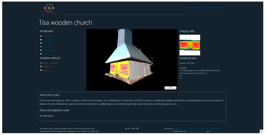
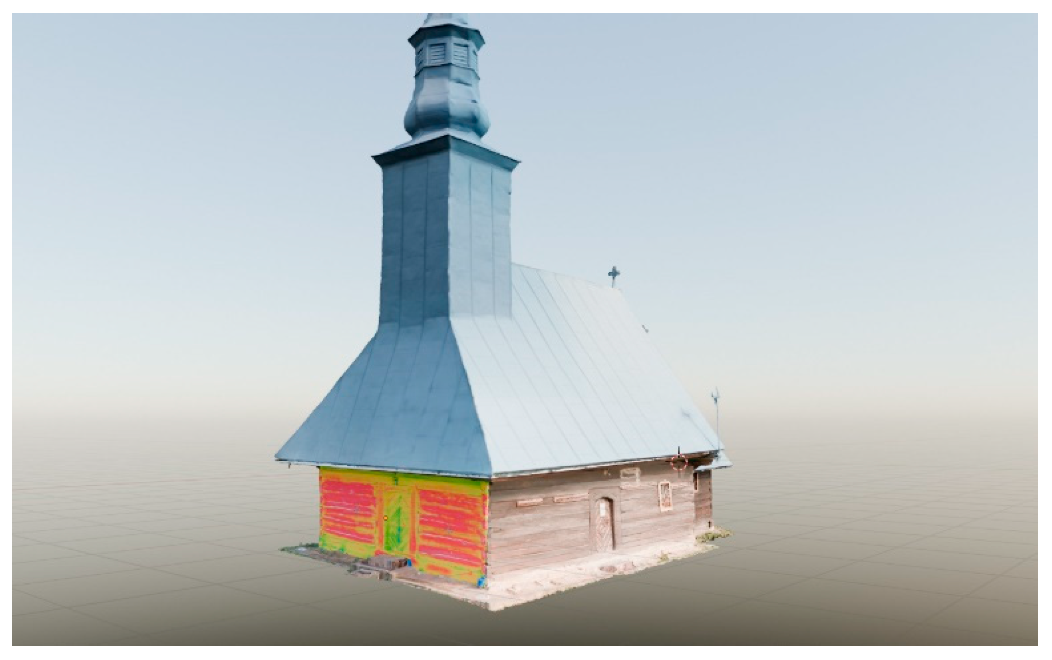
Figure 2.
Screen capture within 3D-Vimm of Tisa wooden church, with the west exterior wall displaying a thermal texture and the north wall displaying a Matcap texture.
- Browser-Based Access: Seamless usability via any web browser without requiring plug-ins or third-party applications.
- Simplified Project Configuration: Effortless setup and data upload for diverse cultural heritage assets, beyond just buildings.
- Interactive 3D Visualization: An intuitive graphical interface for immersive exploration.
- Local Data Storage: Secure management of 3D and imagery data without external dependencies.
- Versatility: Easy adaptation for various projects or institutional requirements.
- Database Independence: Compatibility with any database management system for future deployments.
- Multimodal Data Integration: Mapping imagery data from diverse sensors onto specific 3D model elements.
The proposed approach addresses the need to logically and visually link imagery data from various sensors to elements of realistically digitized historical buildings or artworks, enabling access through an open, interactive online environment. While previous methods based on photogrammetric models or 3D scans [25] laid important groundwork, the proposed solution simplifies the integration of multimodal imagery and enhances the realism of 3D visualizations.
Several web-based platforms for Cultural Heritage visualization, such as 3DHOP [26], Smithsonian Voyager [27], ATON [28], and Virtual Interiors [29], use WebGL along with frameworks like Three.js and Babylon.js to provide interactive 3D model viewing with annotation capabilities. These platforms are well established and widely used for presenting and contextualizing digitized heritage assets. While they focus on optimized rendering and scholarly annotations, 3D-VIMM is still in development, exploring ways to integrate multimodal imaging data through interchangeable textures. This approach aims to allow overlaying different imaging datasets (e.g., thermal, UV fluorescence as seen in this study but also being capable of integrating infrared, hyperspectral, or X-ray imaging) onto 3D models, potentially improving comparative analysis and interpretation within a single interactive environment.
Built on a minimalist MVC framework (CodeIgniter4 [30]), the platform ensures compatibility with diverse database management systems and WebGL libraries (e.g., Three.js), enabling seamless and efficient operation.
A key feature of this web application is its custom interactive 3D viewer, developed using Three.js, a JavaScript library designed for WebGL (Web Graphics Library). WebGL [31] is a JavaScript API that enables direct GPU access for rendering 2D and 3D graphics in web browsers without requiring plugins. Three.js [32] simplifies the complexities of WebGL, providing developers with an easier and more efficient way to create interactive 3D visualizations.
Another important feature is the MatCap view option so surface details can be seen without the color texture. MatCap (Material Capture) is a technique used in computer graphics to simulate the lighting and materials of a 3D object in a simplified way. This method uses a predefined texture, called “Matcap”, which incorporates both material and lighting information, allowing for fast and efficient rendering of 3D surfaces. Instead of calculating lighting, reflections, or material properties in real time, Matcap uses a single 2D image that is mapped onto the object’s surface, giving it the desired appearance. This technique is extremely useful in applications where performance is crucial, such as fast previews, 3D modeling, or web applications. The Matcap texture is applied by mapping the object’s normal coordinates to the texture so that every point on the model surface is colored according to its orientation in space.
An important viewport interface element is the adjustable scale. The scale is first computed by determining a ratio resulting from transforming a metric unit at a given depth into screen units (pixels). This is carried out by calculating the cross-product of the forward direction of the camera and the vector indicating the “up” direction of the world, effectively generating a left/right vector in camera space. At the given depth along the front direction of the camera, we take 0.5 m along the left vector computed earlier, then 0.5 m along the negative left vector. By projecting these two points using the current projection matrix and taking the difference between the two, we obtain the size in screen units (pixels) for a metric unit at the given distance from the camera. Then, using a fixed pixel value to represent the scale bar, we transform that fixed pixel value into metric units using the ratio calculated previously. A very important aspect of the whole scale calculation process is the projection matrix used. For perspective projection, a unique scale value is obtained for each point on the screen, whereas if an orthographic projection is used, the calculated scale value will remain constant across the entire screen.
A heritage building project is selected to view its automatically generated page with the information in the database. A list of sub-objects in the building 3D model is displayed from which the user can choose and select. Upon selecting one of the components the viewport camera is positioned to a frontal view of the building section, and another list opens up to display all the available imaging data for that building section. Selecting one of the options in the list will change the section texture in the viewport to display the imaging data. Other fields in the user interface display images, paradata and metadata, and other descriptions from the database for that specific section or imaging method.
3. Results: A Case Study of the Tisa Wooden Church
To illustrate the capabilities and outcomes of the platforms discussed, this section presents a case study on the Tisa, Arad County, wooden church (see Figure 3). This monument, a representative example of Romania’s wooden cultural heritage, was selected for 3D digitization and multi-modal imaging to demonstrate the integration and application of advanced documentation methods. The collected data were processed and made available through the 3D-VIMM platform, showcasing its versatility in visualizing and analyzing heritage information. Furthermore, the results were cross-referenced and linked with the Biserici Înlemnite database, enriching the broader inventorying documentation.
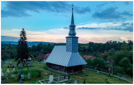
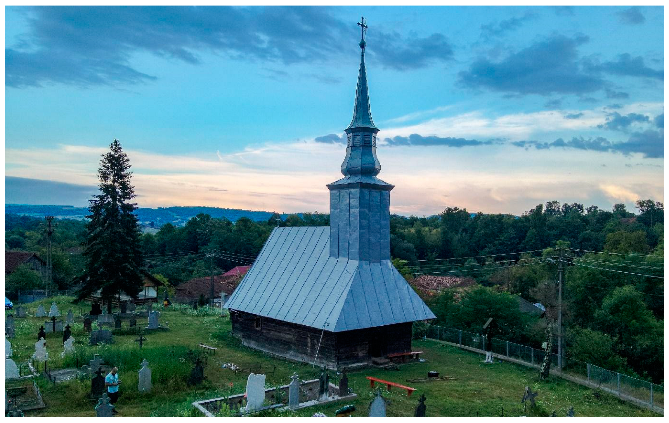
Figure 3.
Tisa wooden church aerial view.
3.1. Historical Context
The church, dating back to 1760, is located in Arad County, Romania, and is dedicated to “Saints Peter and Paul”. Its history is marked by multiple modifications and interventions over the centuries. It is believed that the Dărău family originally funded its construction, highlighting the connection between the local community and this religious structure.
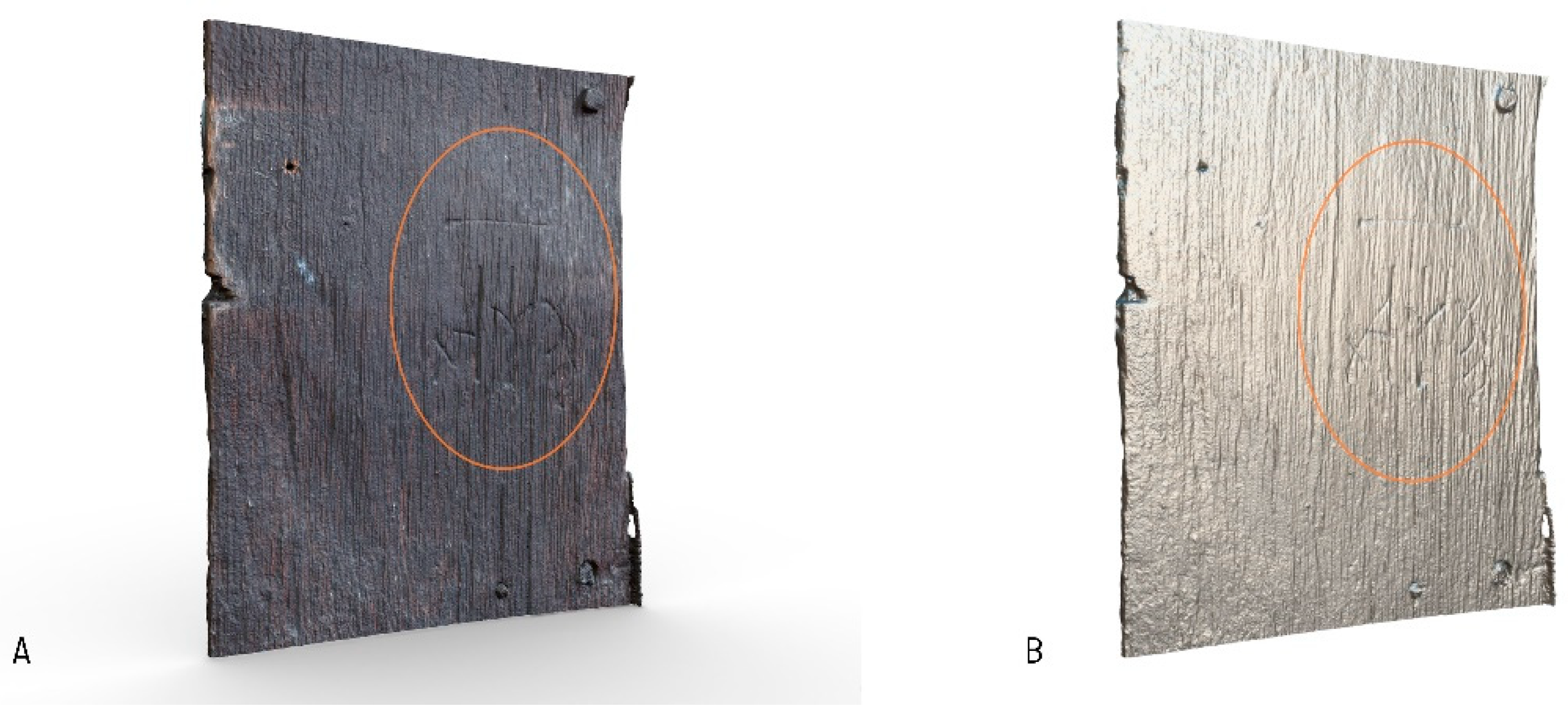
An inscription in Cyrillic letters on the altar’s exterior southern side (see details in Figure 4) confirms the 1760 construction date. In 1795, the church’s iconostasis was decorated by master painter Constantin Râșcan, who also painted the imperial icons, including a depiction of the Virgin Mary with the Child, bearing the same date. In 1864, the church was fully painted by Demetrovici, a painter from Timișoara, and around 1920, a metal roof covering and likely a new choir were added.
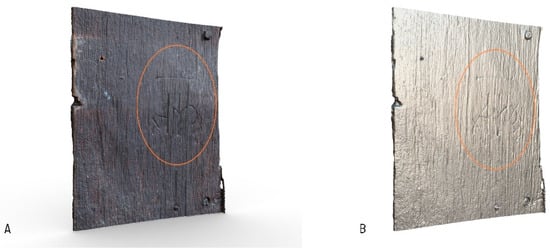
Figure 4.
A 3D view of the section with the inscription: (A) color view; (B) surface detail view (Matcap).
The First Josephine Survey [33], conducted during the Habsburg era, records the village under the name Tijsza and locates the church precisely where it stands today.
In 1820, repair works included enlarging the nave by extending the walls outward. Historian Coriolan Petranu noted another significant restoration in 1890 [11]. The tower shows evidence of reused elements with Cyrillic inscriptions, suggesting either later modifications or an initial construction using materials repurposed from another building. The church follows the typology of constructions with a recessed sanctuary. Its foundation is made of stone, while the plinth is stone-bound with mortar. The structure is crafted from hardwood, joined in a dovetail, and the entire framework is carved from thick beams, a technique common to the region. The nave features a semi-cylindrical vault made of thick hardwood boards. The frame joints are primarily secured with wooden nails, though metal nails were also used in some areas. The interior painting is executed using the distemper paint technique, with animal glue likely serving as the binder, applied on a gypsum layer. These details reflect a complex blend of styles and construction techniques, granting the church its distinct character and underscoring its cultural and historical significance.
3.2. Data Acquisition
The historical data were collected during the June–August 2021 timeframe, before the beginning of the field campaign, and their accuracy was verified on-site during the completion of the inventory sheet in September 2021. The inventory team involved one historian, one architect, one art restorer, and three assistants. The data had been collected in just one day in the field. The church had been previously checked on a preliminary visit with the whole team, and then each professional dealt with their specialty while filling in the inventory sheet.
The images were uploaded on the “Biserici Înlemnite” platform at a later date, and further edits to the data in the inventory sheets were made. The chapter that discusses values had been filled in on-site and was later discussed with the whole team for adjustments.
The imaging data for the 3D-VIMM platform were acquired in July 2024 during a two-day fieldwork session. The work plan included the 3D digitization of the church’s exterior and interior, along with targeted imaging investigations of specific sections using thermal and ultraviolet techniques. Wood moisture measurements were conducted at multiple key points to help assess the condition of the structure.
Additionally, a series of paint samples from the wall paintings inside the church were also collected. These samples were subsequently analyzed in the laboratory using complementary spectroscopic techniques—FTIR (Fourier Transform Infrared Spectroscopy), XRF (X-Ray Fluorescence), and LIBS (Laser-Induced Breakdown Spectroscopy)—with the aim of identifying the painting materials used and characterizing the painting’s stratigraphy [34,35]. The experimental conditions used for spectroscopic data acquisition and data analysis were as described in [36].
3.2.1. Three-Dimensional Digitization
To implement and test the proposed concept, 3D digitization, using photogrammetry, of both the interior and exterior of the church was performed for a unified presentation. Photogrammetry was the only method used in this case due to its versatility for aerial/terrestrial/interior seamless compatibility [37] but especially for the color correction required for interior wall paintings. The budget was also one of the deciding factors. The processing workflow consisted of image processing of the RAW files with white balance and color correction (batch processing with Adobe Lightroom Classic).
Image set acquisition made use of scale bars and ground control points with coded targets for automatic detection for photogrammetric software, white balance, and color calibration charts. The end goal was to generate 3D meshes with high-resolution textures. The photogrammetric reconstruction was carried out with Agisoft Metashape 2.0 PRO. The 3D model generation method used was Depth Maps and the quality factor for both Image Alignment and Mesh generation steps was High.
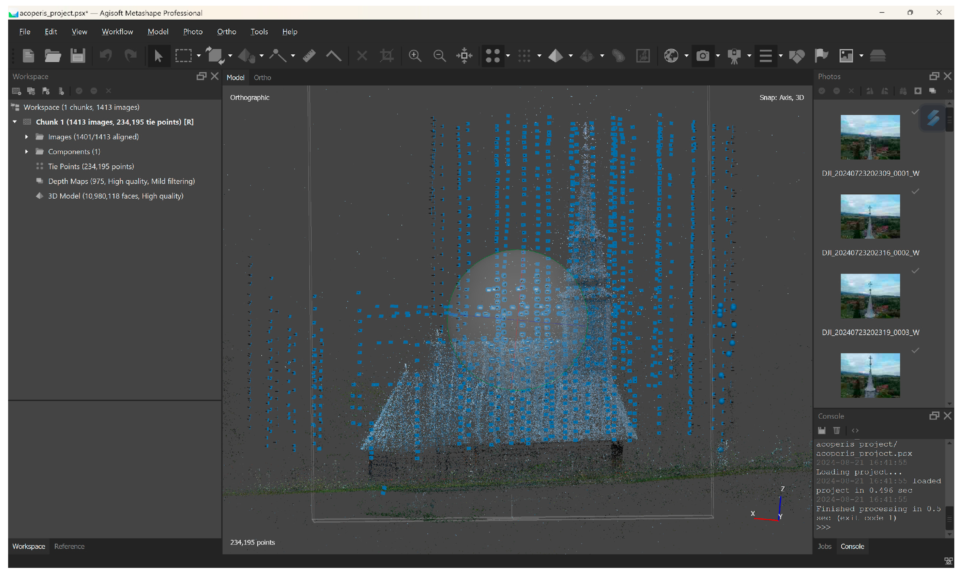
A detailed data acquisition plan was developed to create a complete 3D model. A telescopic pole was initially considered for capturing both the exterior church walls and the roof using the same camera sensor. However, due to time constraints, an unmanned aerial system (UAS) drone—the DJI M30T model—was used for digitizing the roof. This system includes three cameras that capture simultaneously: a wide-angle camera (12 megapixels), a zoom camera (48 megapixels), and a thermal camera (640 × 512 pixels).
To capture the entire roof, a total of 1413 images were recorded (for each camera system), with the camera positions shown in Figure 5. For the photogrammetric 3D reconstruction, the wide-angle camera images were used.

Figure 5.
Roof 3D digitization: camera positions after initial image set alignment.
The photogrammetric processing resulted in a mesh model with 11 million polygons with a spatial resolution of 6.37 mm/pixel, which was reduced through simplification and optimization to 100,000 polygons. While the 3D reconstruction also included the church walls, this section was not incorporated into the final model assembly.
The roof posed additional challenges during processing due to the reflective nature of the metal material, which caused reconstruction errors, especially near the tower, despite capturing data on a cloudy day to avoid direct sunlight.
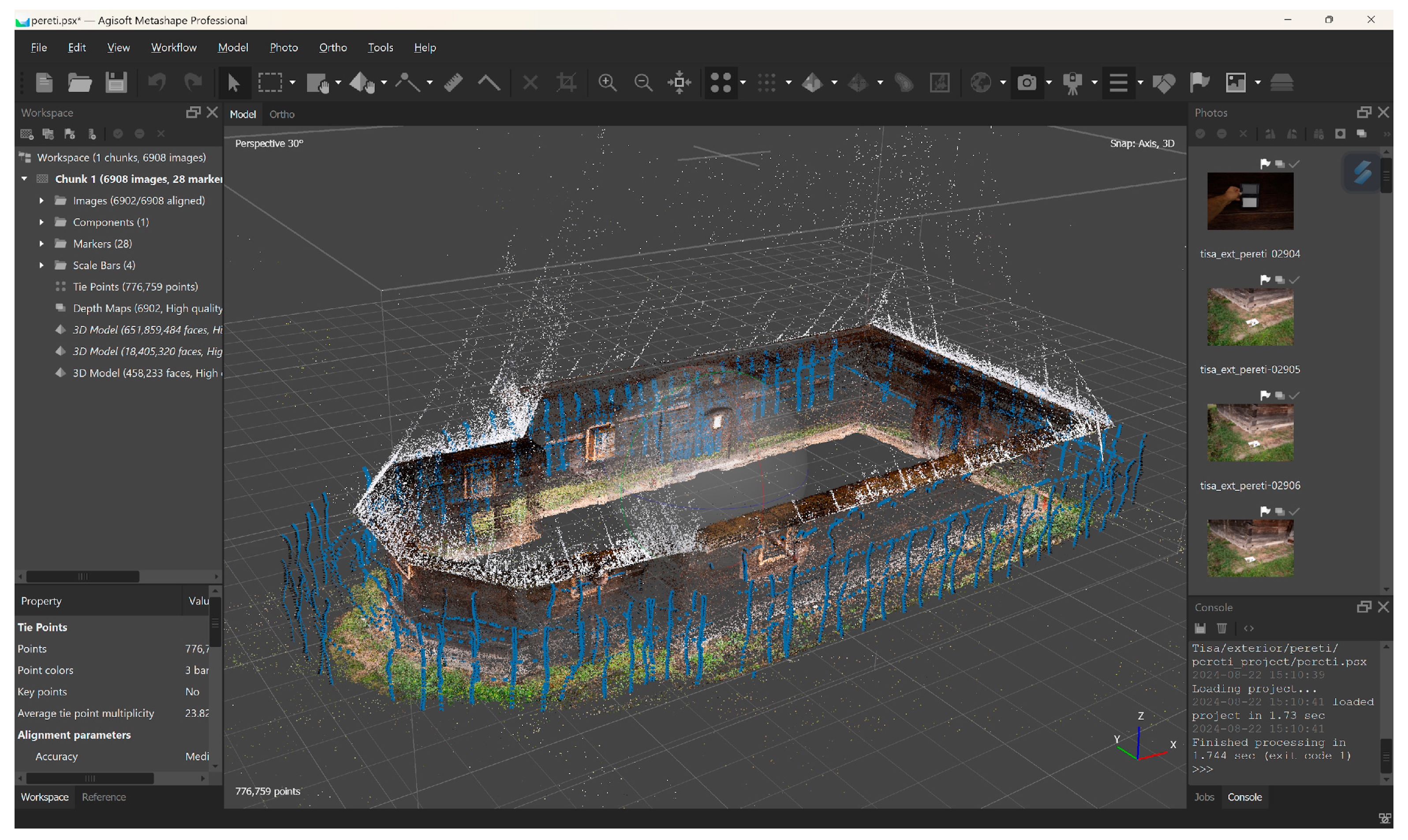
The exterior walls were digitized from the ground level using terrestrial photogrammetry, employing a Sony AR3 professional camera with a full-frame mirrorless sensor (42 megapixels). The Tamron f2.8 17–28 mm lens, set at a focal length of 17 mm, was used for the recordings. A total of 6908 RAW images were captured, with special charts for white balance and color profiles.
Particular attention was given to decorative elements around the doors and windows, as well as a separate scan of a wooden inscription partially hidden beneath an exterior coat rack. Figure 6 displays the point cloud resulting from the processing of the exterior images.
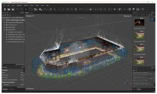
Figure 6.
Exterior walls 3D digitization: estimated camera positions.
The main goal of the digitization was to capture relevant details about the structure and wood quality of the walls. The processed data resulted in a point cloud with 652 million polygons with a spatial resolution of 0.423 mm/pixel.
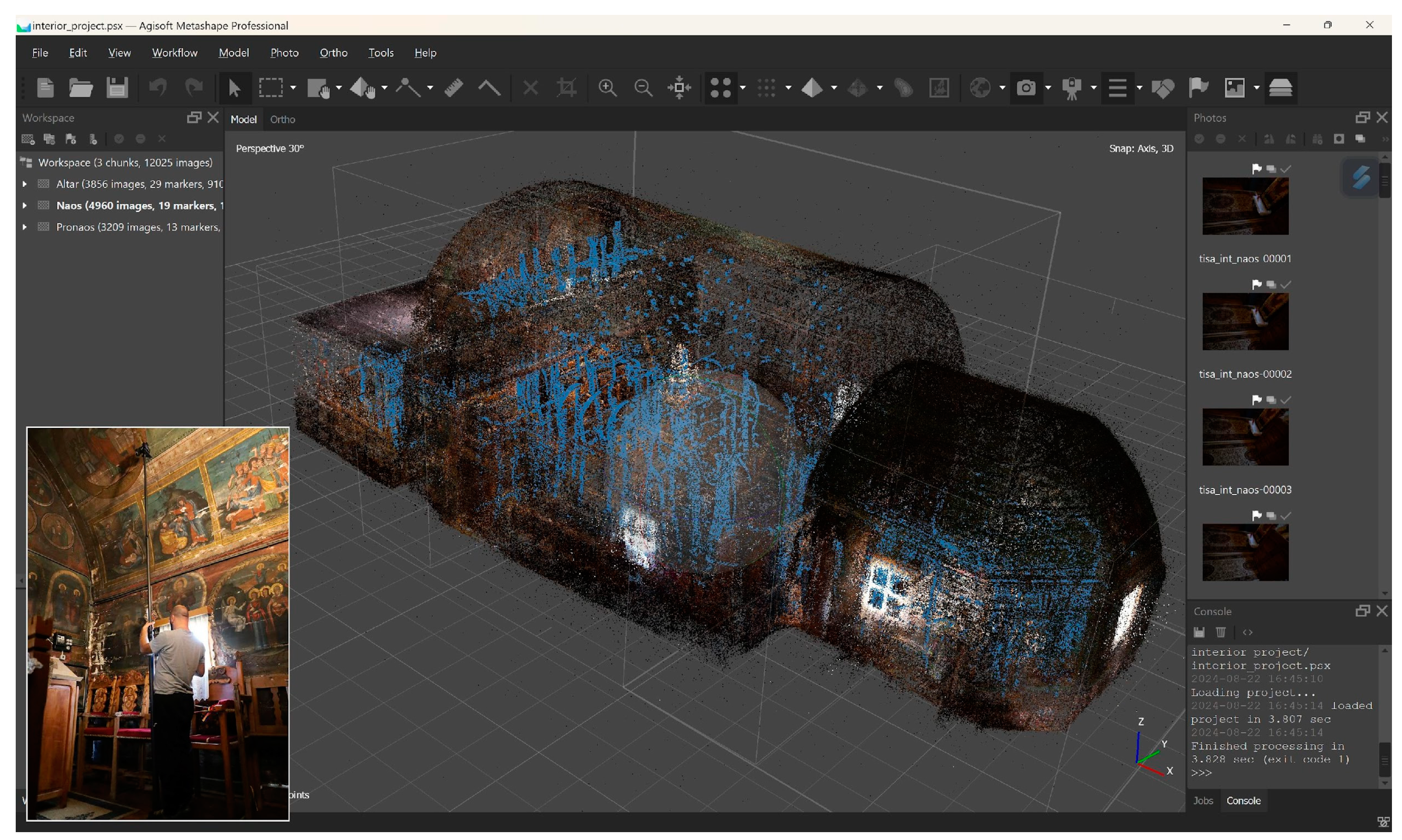
For the interior, the same camera and lens were used. A telescopic photography pole (Photomast) was employed to capture the ceiling and high areas of the walls and iconostasis. To ensure uniform image quality, additional LED panels on tripods (2.3 m) were used for lighting.
A total of 3856 images were recorded for the narthex, 4960 images for the nave and choir, and 3209 images for the altar. All images were captured in RAW format. Due to the chromatic components of the murals, the white balance, and color profile charts were essential.
Figure 7 shows the alignment of the chunks representing the three interior sections: narthex, nave, and altar, along with the camera positions during data acquisition with the photography pole.

Figure 7.
Interior digitization with the three chunks aligned. Left corner: photography pole used.
Each of the three regions was recorded and processed separately and then aligned as chunks in the photogrammetric processing software. The final processing resulted in a total of 457 million polygons with a spatial resolution of 0.872 mm/pixel.
During the optimization process, two models were exported for each digitized element in Wavefront OBJ format: a high-poly mesh (10–15 million polygons) and a low-poly mesh (ranging from 10,000 to 500,000 polygons depending on the complexity of the element). The low-poly meshes serve as the base models for the next stage of data preparation, along with high-resolution textures (8192 × 8192 pixels). The high-poly meshes were used to bake the high-quality normal maps for low-poly meshes but also as stand-alone deliverables.
3.2.2. Thermal Imaging
Infrared radiation use in building inspections is not new. Thermal imaging is essential in monitoring and documenting heritage buildings as it delivers non-invasive visual and qualitative information about the conservation status of built structures. Issues like humidity, plaster detachment, cracks or other wall defects can easily be emphasized with a thermogram [38,39,40,41,42,43,44,45]. The basic principle of thermal imaging relies on the detection of infrared radiation emitted by surfaces, which correlates with their temperature. Variations in surface temperature reveal hidden material properties or structural anomalies, making it an effective diagnostic tool in conservation practices. In most cases, for better results, a temperature contrast is needed.
For this case study a similar approach to the documentation of Golești Church in [21] was carried out, using two IR camera systems for the roof and the walls, respectively. The roof survey was carried out simultaneously with the visible and thermal cameras as mentioned in the previous section. The 1413 thermal images were recorded in JPEG format, so no special thermal processing was carried out. The intent was purely demonstrative to generate a thermal texture for the roof that could be used in the online platform.
A second camera, FLIR T1020, was used for ground thermograms of the walls and interior. This is a professional thermal camera with a resolution of 1024 × 768 pixels and image stabilization. Special attention was given to areas where surface humidity was high and to the walls with the entrances (south and west walls).
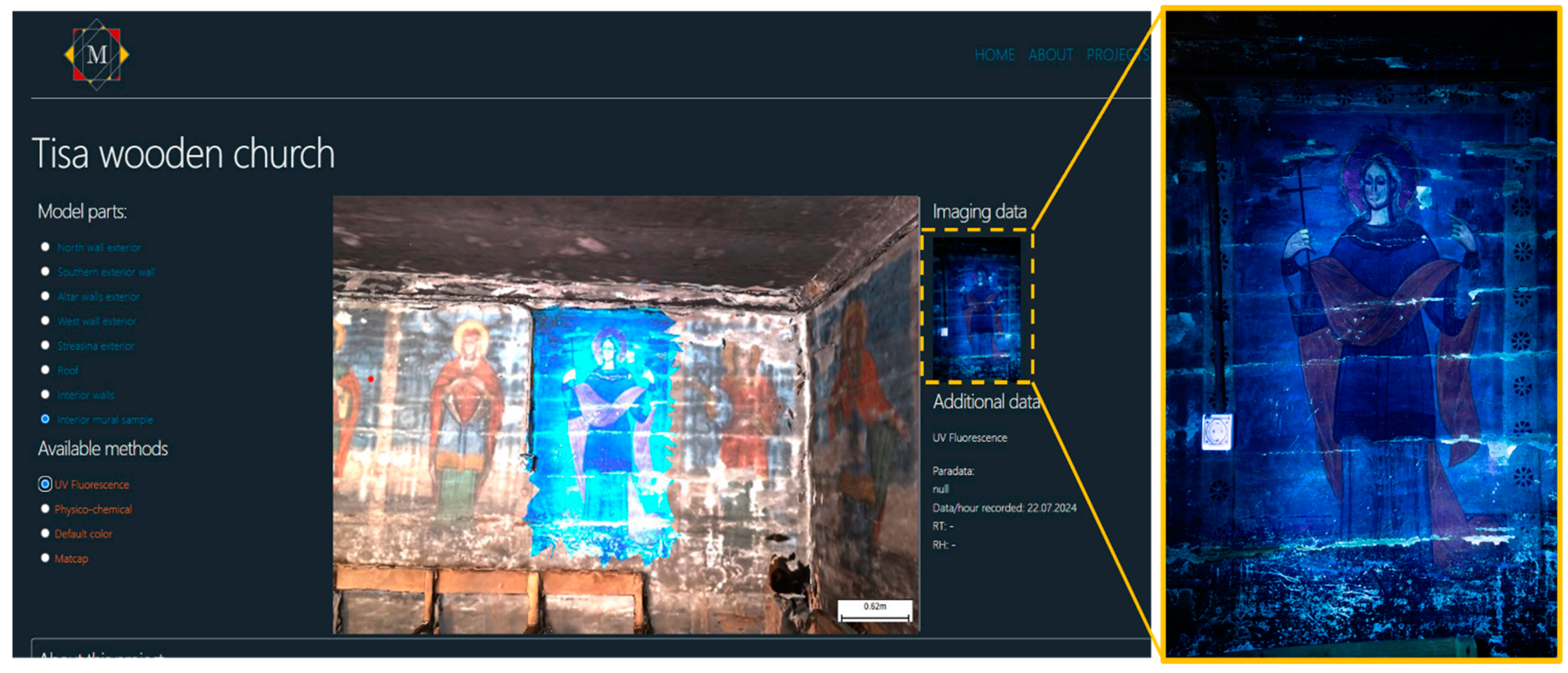
3.2.3. UV Fluorescence Imaging
UV fluorescence is based on a physical phenomenon in which the molecules of a material absorb ultraviolet radiation, characterized by high energy and short wavelength (below 400 nm). Upon absorbing this energy, the molecules enter an excited state. To return to their ground state, they re-emit part of the absorbed energy in the form of visible light, at a longer wavelength (typically between 400 and 700 nm). This re-emitted light is observed as UV fluorescence, which can vary in intensity and color depending on the chemical composition of the material.
UV fluorescence is particularly useful in the study of cultural heritage materials, such as wall paintings and icons [46], as it can reveal details invisible under normal light. For instance, it can highlight differences between original pigments and those used in later restorations, areas affected by degradation, or even reveal hidden inscriptions. The effectiveness of this technique depends on the specific wavelength of the UV radiation used, as well as the sensitivity of the imaging equipment, which must accurately capture the visible light emissions generated by fluorescence [47,48].
For this study, areas of interest included certain wall paintings in the narthex. UV lamps from Karl Deutsch, with a peak at 365 nm and an intensity of 60 W/m2 at a distance of 0.4 m, were used to highlight potential areas of interest through UV fluorescence. The fluorescence manifests within the visible band of the electromagnetic spectrum, and thus images were captured with a Sony A7R3 camera at night in RAW format. Capturing images in RAW is crucial as it preserves all spectral details of the fluorescence, without information loss due to compression, facilitating subsequent detailed and accurate analysis.
Several images were captured (see Figure 8) where the surface showed intense fluorescence: the green coats and the halo of the characters. From some of these areas, samples were collected for laboratory physical–chemical investigations.
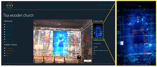
Figure 8.
Screen capture with the UV layer of one of the murals in the church narthex.
3.2.4. Microclimate Monitoring
Wooden structures are particularly sensitive to environmental conditions [49]. Wood, as an organic material, reacts to humidity and temperature by expanding and contracting, which can lead to cracking, warping, and, over time, degradation of the structure [50,51]. Moisture fluctuations can also encourage the growth of molds and other biological organisms that damage wood.
By installing microclimate sensors in wooden churches, it is possible to continuously monitor variations in temperature and relative humidity, whose improvement is critical for maintaining the integrity of these structures. The data collected allow for the early identification of problems and the implementation of preventive measures, such as adjusting ventilation, installing humidity control systems, or even modifying the use of space to better protect sensitive materials.
Temperature and relative humidity are two fundamental parameters for assessing the state of preservation of wooden churches. Large temperature variations can cause wood to expand and contract, affecting structural stability. Also, too high temperatures can accelerate the biological and chemical degradation processes of wood. Relative humidity is a critical factor in maintaining the health of the wood structure. Excessive humidity can lead to water absorption by the wood, favoring warping and rotting, while too low humidity can cause drying and cracking of the material.
The sensors are strategically placed at different points in the church, both inside and outside, to provide a detailed picture of the microclimate. These sensors can be connected to monitoring systems that alert maintenance staff when values exceed set critical thresholds, allowing rapid interventions to protect the structure.
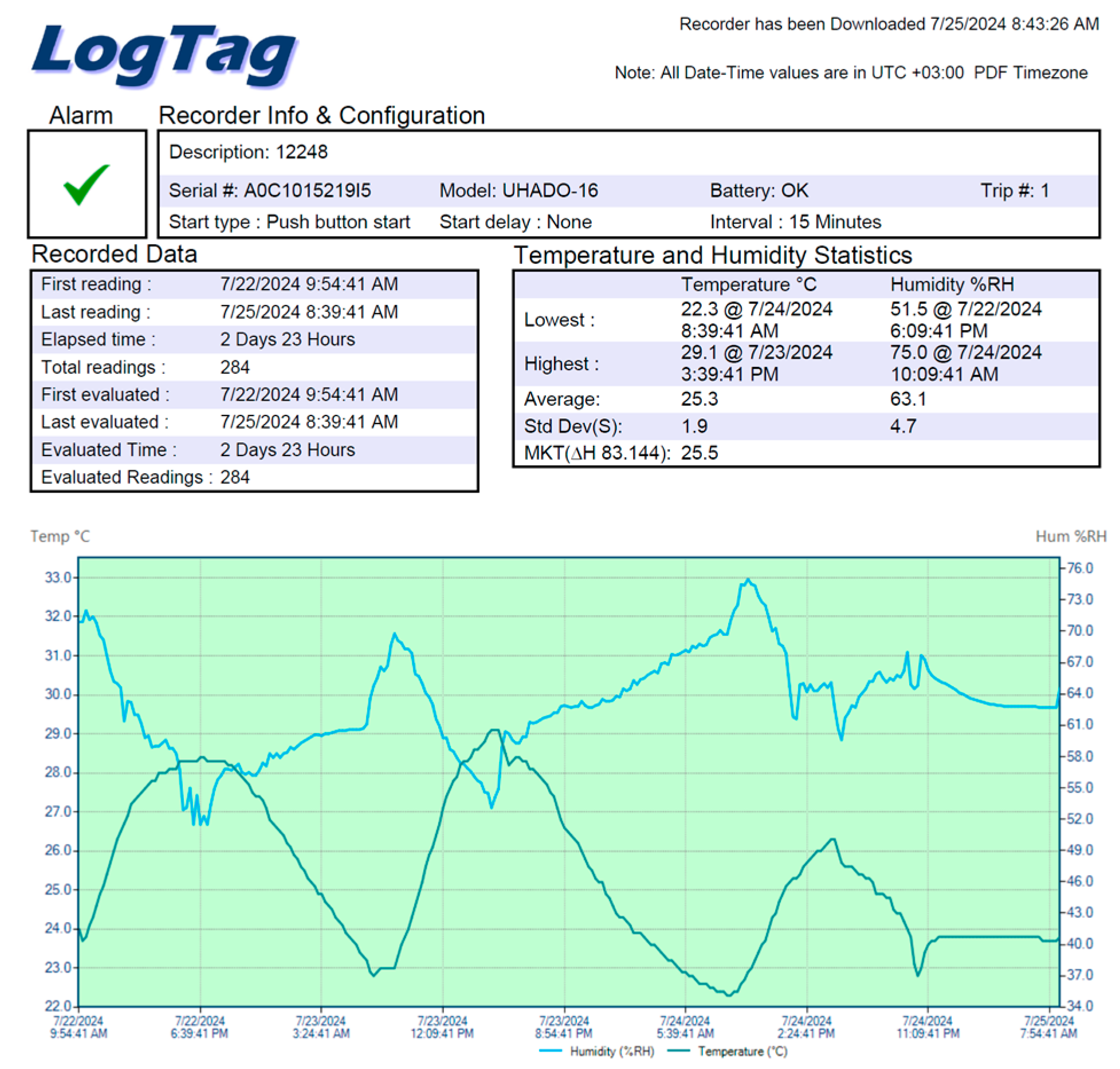
In this experiment, one EasyLog sensor was placed outside the church on the north wall and two LogTag sensors were placed inside the church, in the chancel and the altar, at different heights (chancel—2.7 m and altar 0.6 m). The data that they collected are used in the platform as full reports (see Figure 9), but in future developments, these will be used interactively.
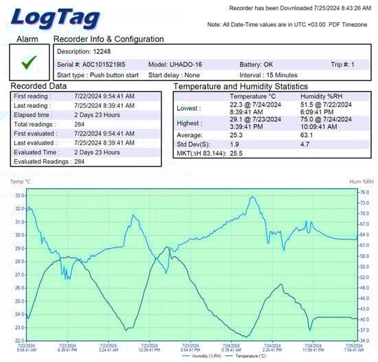
Figure 9.
A full report of the data collected by sensor 12248.
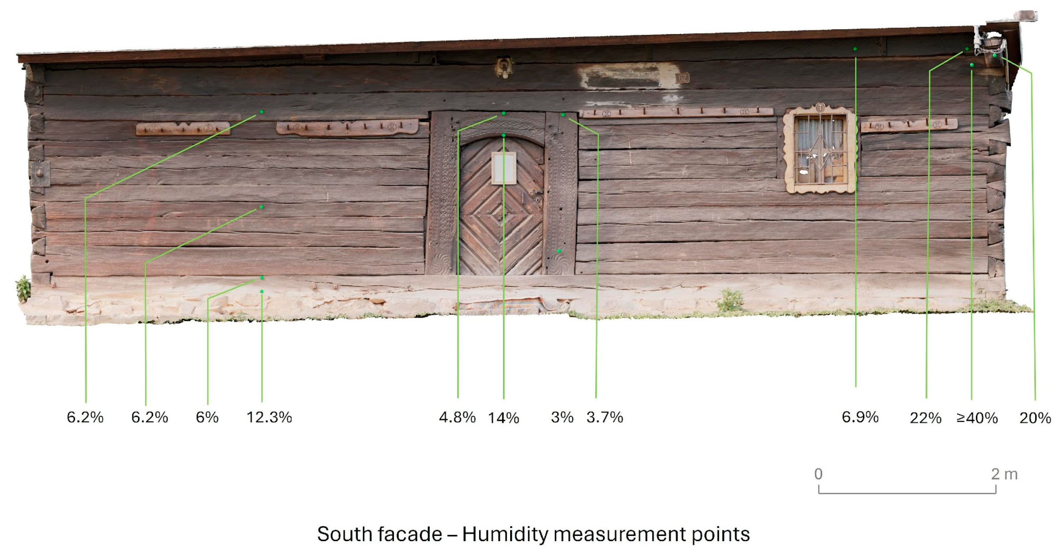
3.2.5. Surface Humidity Measurements and Discussion
Wood is a hygroscopic material. As such, it tends to reach equilibrium with the humidity around it. To be able to correlate the information collected, the moisture content of the beams that make up the walls of the church was measured at several points. A total of 80 measurements were taken both inside and outside. An instrument for measuring the moisture content in wood and materials, Testo 616, set to the characteristic curve of hardwood was used. The measuring depth was up to 5 cm.
As expected, in some areas on the north-facing walls, the moisture content of the wood was generally higher than on the other sides.
In the lower area, at the sill beams, a higher moisture content is observed. The higher values are most likely due to the contact with the stone and mortar base, materials that conduct moisture by capillary action. But as you go higher, the values decrease. Thus, although values of 15%, 19%, 21%, and 23% are recorded at a height of 5 cm, already from 20 cm in height, still on the same sill beam, the values decrease to 3%, 4%, 9%, and 6% (except in the north where they are also higher at 14%,16%, and 17%).
Higher values (22%, ≥40%) are recorded on the southern wall, in the upper part, at the contact of the last beams with the cantilever that separates the nave from the altar. The wood in that area is degraded, showing light-colored halos and weakened areas. At present, there is no degradation on the roofing that would allow infiltration of rainwater. It can be assumed that the area was affected for a longer period of time in the past, but due to the embrittlement of the area, it has become more permeable to relative humidity.
In the interior, mostly areas with exposed wood from the gaps in the paint layers were measured. There were cases where just to respect the same height position of the measurement, the values were recorded through the paint layer. In most areas, this layer is about 3 mm thick. Compared with adjacent areas without a pictorial layer, the presence of the pictorial layer is not considered to influence the measurements.
Figure 10 depicts the position of the measurement points on the exterior southern wall overlapped on an orthomosaic extracted from the digitized 3D model of the church.
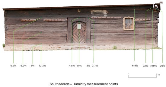
Figure 10.
Humidity measurement points on the south exterior wall.
3.2.6. Physicochemical Analysis of Samples
Complementary FTIR, XRF, and LIBS analyses were performed on a group of five paint samples taken from the wall paintings inside the church. These samples were collected from areas exhibiting paint layer detachment and encompass most of the existing color palette, including blue, green, reddish-brown, and gold hues.
FTIR spectra revealed in all the investigated samples strong bands attributed to gypsum (calcium sulfate dihydrate)—characteristic bands centered at 3530, 3400, 1620, 1100, 670, 610, and 590 cm−1 [52]. The presence of gypsum is most likely associated with the ground layer, a hypothesis supported by the strong Ca and S lines detected via XRF and LIBS analysis.
Regarding the color palette, a copper-based pigment was identified for the green hues (high Cu content), Prussian blue (characteristic IR peak at 2090 cm−1) admixed with lead white (high Pb content) for the light-blue hues, and iron-rich ochres (high Fe content) for the reddish-brown hues. In addition to copper, high levels of arsenic were also detected in the green-painted areas, suggesting that emerald green, a copper-acetoarsenite widely used in the 19th century, may have been employed [42]. The use of gold foil, applied over an earth-red bole layer [53], was confirmed through both XRF and LIBS analyses.
In terms of painting technique, the use of a protein binder could be inferred via FTIR based on the weak but characteristic absorptions observed around 1640–1647 cm−1 (amide I), and 1540 cm−1 (amide II), respectively. Degradation products in the form of calcium oxalates were also detected in most of the samples via the sharp IR peak centered at 1320 cm−1 [53].
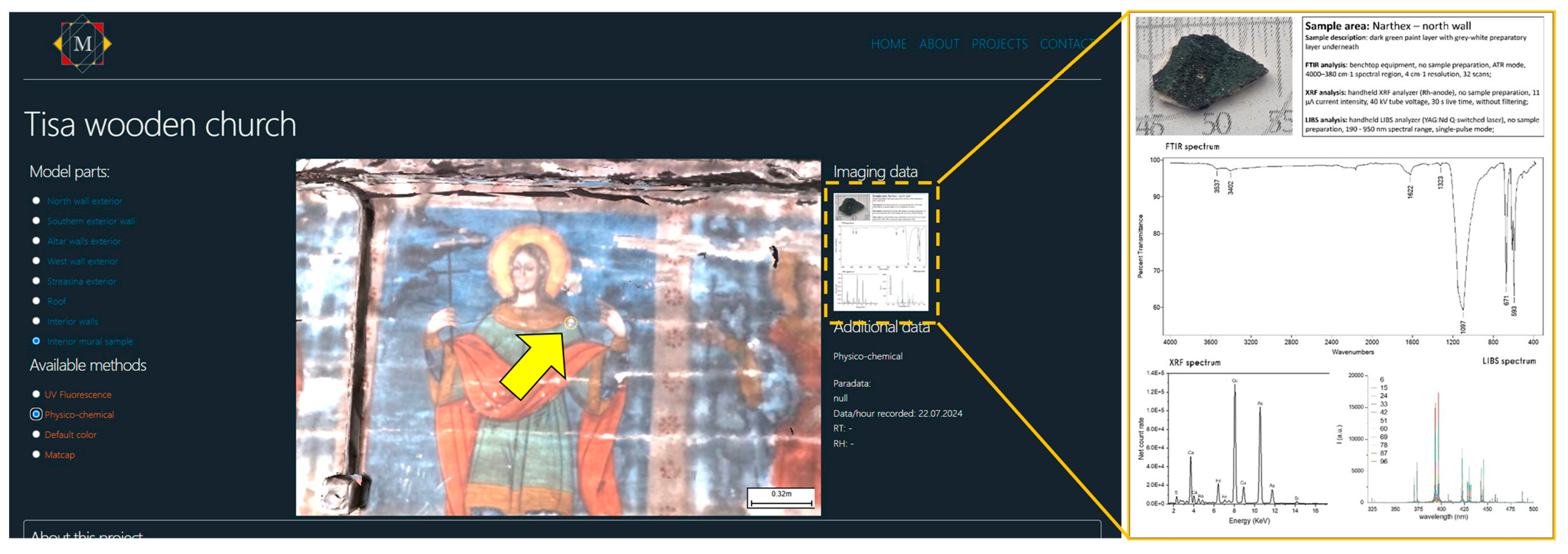
In the 3D-VIMM platform, these types of data are viewed by interacting with visible hotspots (small yellow dashed line circle in Figure 11) in the 3D scene, each hot spot corresponding to the location where the respective sample was collected. The information is displayed as a minimal data sheet (see Figure 11, right side) containing the name of the sample, a short description, the analytical methods used, and a spectrum for each of the methods.
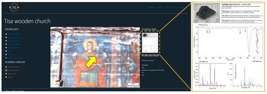
Figure 11.
Screen capture with the position of a sample location with physico-chemical analysis, marked with a yellow arrow here.
3.3. Data Preparation for Database Input and Online Presentation
3.3.1. The Concept and Method Behind 3D-VIMM Data Preparation
The 3D-VIMM platform is based on a simple concept in which the presented subject is uploaded as a single 3D model with multiple textures, descriptive images, text descriptions, metadata about the subject, and paradata regarding the imaging and investigation methods parameters. The 3D model is composed of multiple sub-objects, and meshes, each with intuitive names that are automatically loaded into the database upon the project upload. In 3D modeling, a “mesh” refers to the geometric structure consisting of vertices, edges, and faces (or polygons) that define the shape of the object. The 3D model can also contain lights, texture, and material information or animation frames.
An easy way of presenting imaging data projected onto the surface of the object in the 3D scene is to create textures for the same size of the area covered by the imaging data. This step requires cutting out that area from the digitized model, regenerating the UV maps (texture coordinates), and then baking the original texture to the new texture coordinates so that the image file of the texture resembles the aspect and ratio of the real object area. This way the imaging data can be referenced in the new UV map coordinates resulting in a new texture file.
The first step of this method was already explained in the previous sections, where the photogrammetric model is simplified and saved to disk in two variants (low and high poly). The second step is the separation of the areas of interest in the low poly model. The UV maps are regenerated and new color textures are created and saved to disk. The third step involves transferring all geometric details from the high-poly mesh to the low-poly mesh. This is achieved through various methods, with the most efficient, in our experience, being the use of Adobe Substance Painter for generating (baking) normal maps from the high-poly mesh and exporting them as textures.
Normal maps are essential in online 3D viewing as they enable detailed surface textures to be represented without increasing the polygon count of the model. They encode surface details, such as bumps and grooves, from high-poly meshes onto low-poly models, creating the illusion of complexity while maintaining low computational demands. This ensures smoother performance, faster loading times, and enhanced realism in web-based applications. Additionally, normal maps are widely supported by visualization frameworks like Three.js, making them a standard for optimizing file size and rendering efficiency in interactive 3D environments.
After these steps, the resulting meshes are also named in a logical and easy-to-understand manner and the scene is saved as a single 3D model in Autodesk FBX file format. This format was chosen for its efficient compression and compatibility with various 3D editing and viewing programs.
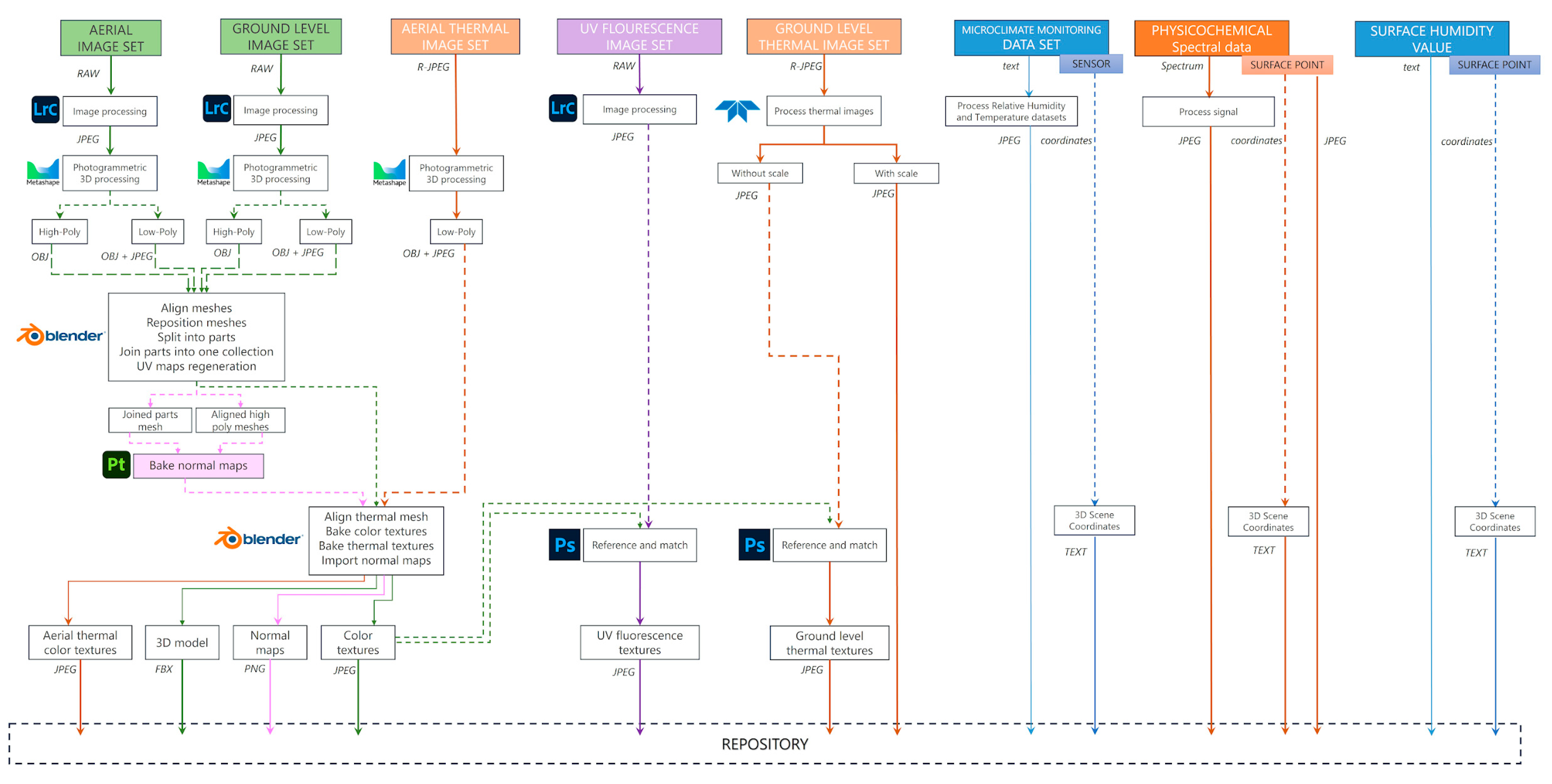
Figure 12 depicts the entire workflow for all the data sets from data acquisition, through processing and data preparation for the online repository and interactive view on a web page.
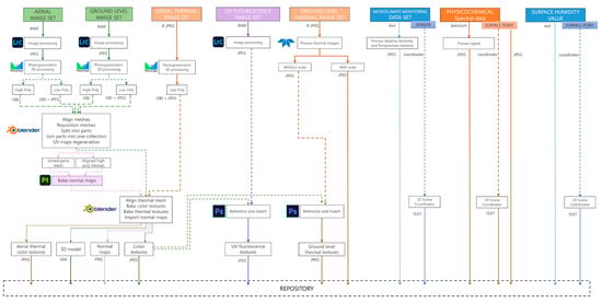
Figure 12.
Data workflow from acquisition to the repository (adapted from [21]).
3.3.2. Three-Dimensional and Imaging Data Referencing
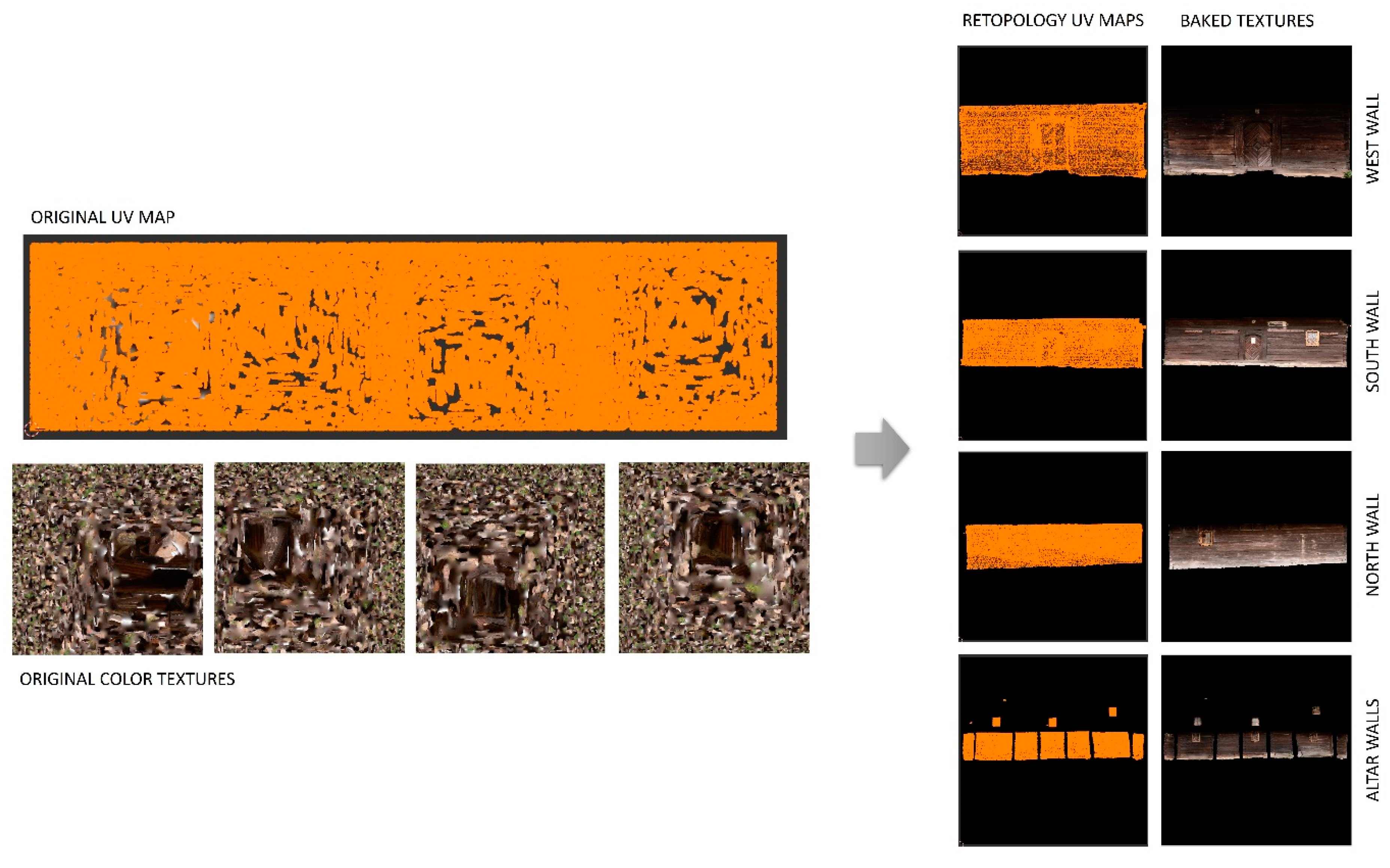
In this case study, the Tisa church 3D digitization resulted in three generated 3D models: the roof, exterior walls (Figure 13), and interior areas. For the 3D-VIMM platform, the singular 3D model that was uploaded contained one mesh for the roof, four meshes for the exterior walls, and four meshes for the interior. The aerial thermal photogrammetry resulted in another 3D model with a thermal texture that was baked in Blender as a new texture for the roof of the uploaded 3D model.
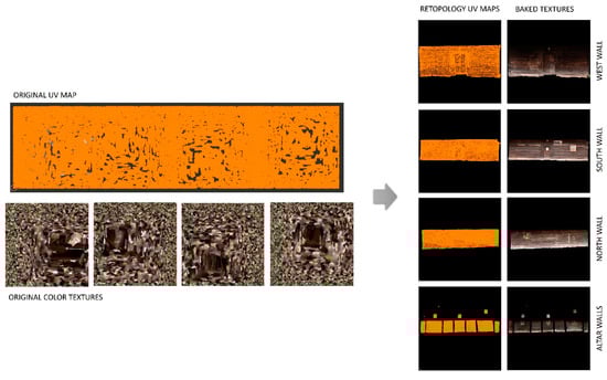
Figure 13.
Exterior walls—original UV maps and color texture vs. UV maps after retopology and the new baked textures.
Ground-level FLIR camera thermal images were used to create new textures for the selected areas of the exterior walls (see Figure 14). The same with the UV fluorescence images. The new textures were created by modifying the color textures in Adobe Photoshop 2025 by referencing the thermal or UV image on the color texture and saved as new files.
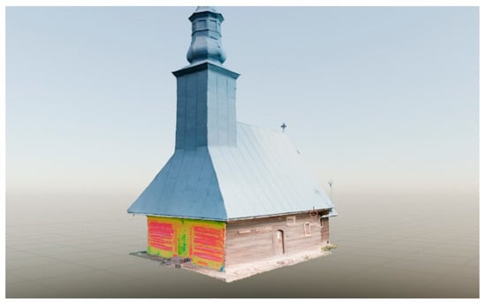
Figure 14.
IR texture on the West exterior wall visualization in Blender.
For the humidity measurements display, new textures were generated for all the walls by adding colored spots on the exact positions of the measurements. A special explanatory image was created (see Figure 10) for each wall indicating the humidity values. All the measurement points have coordinates recorded as well (distance from the ground and one of the lateral walls), so in future developments, these values can also be mapped directly in the 3D scene through different solutions (empty objects or hotspots).
For the microclimate data, no texture was created; instead, the default color texture will be associated. In the database, the explanatory image will display the full report. This is not ideal and a new interactive tool to see the evolution of temperature and relative humidity in time is still in development at the moment.
The physicochemical analyses are associated with empty objects in the scene. These objects are placed in the precise spot where the samples were collected. Each empty object will behave in the platform like a part of the 3D model, having multiple methods of investigation attached to the database.
3.4. Linking the Two Platforms
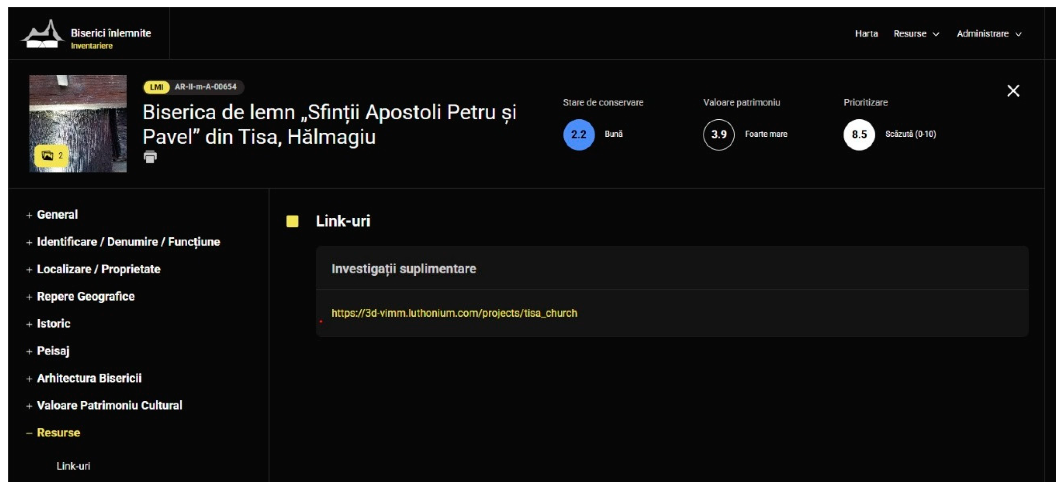
At this stage, the two platforms are not yet designed to work seamlessly together, and their integration relies on manual linking. Currently, hyperlinks are inserted (see Figure 15) in specific sections of a monument’s page to direct users from one platform to the other. For example, on the Biserici Înlemnite page dedicated to the Tisa wooden church, hyperlinks are added in the section detailing the humidity levels of the wood beams, leading users to the 3D-VIMM platform, where the same data is visualized on the church’s 3D model. Similarly, in 3D-VIMM, the monument’s description includes a dedicated field for external links, allowing for a direct connection to the corresponding Biserici Înlemnite page.
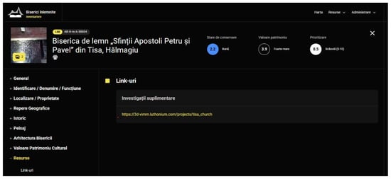
Figure 15.
Screen capture of the Biserici Înlemnite platform showing the resource page for the Tisa Wooden Church entry, which includes a link to the 3D-VIMM platform.
While functional, this approach is limited in scope and does not exploit the full potential of interconnected platforms. Future developments could focus on implementing automated linking based on shared metadata or unique identifiers for monuments, enabling real-time synchronization and context-aware navigation. This could evolve into an integrated interface where users seamlessly access and interact with both platforms, enhancing both the usability and the value of the data. Additionally, incorporating APIs and shared cloud storage would enable dynamic updates and cross-platform collaboration, paving the way for a more robust and interactive digital heritage ecosystem.
4. Discussion
Digital platforms are increasingly present in heritage conservation as tools to enhance the documentation, analysis, and dissemination of cultural heritage. This paper explores the individual strengths and complementary roles of two distinct platforms, Biserici Înlemnite and 3D-VIMM, in the context of studying and preserving Romania’s wooden churches, focusing on the Tisa wooden church from Arad County as a case study. Each platform addresses specific aspects of heritage management, with Biserici Înlemnite focusing on narrative, cultural, and historical documentation, while 3D-VIMM emphasizes technical analyses and environmental monitoring with an interactive visual approach.
To explore the potential of an integrated approach, a collaboration was established between the National Institute for Research and Development in Optoelectronics (INOE 2000) and the NGO Biserici Înlemnite. This partnership aimed to assess how well the distinct methodologies of the two platforms could converge to create a holistic documentation and analysis framework. While the collaboration has yet to produce a fully unified platform that integrates all research seamlessly, it represents a significant step toward interdisciplinary heritage documentation. Currently, data are managed and stored separately within each platform, with cross-references and interlinks facilitating interoperability.
Among the case studies conducted using this collaborative approach, only the Tisa wooden church was selected for inclusion in the 3D-VIMM platform, making it the focus of this paper. To contextualize the urgency and motivation behind the inventorying process of wooden churches, this study begins with an overview of the current state of documentation at the national level. It highlights previous and ongoing efforts to catalog and preserve this type of heritage, alongside the methodology employed by the Biserici Înlemnite NGO in their projects. The paper also addresses critical limitations, including insufficient funding and the limited involvement of specialists, which continue to challenge the preservation of wooden churches. Additionally, it discusses the strategies adopted by the project team to mitigate these obstacles, offering insights into how such challenges can be navigated in future efforts.
The inventory platform’s filtering system is a key feature, enabling the extraction of detailed statistics. Below are some examples: In Iași County, the conservation status of 32 historic churches has been assessed. Among these, five churches are in a very bad state of conservation, with one holding high historical value. Eighteen are in poor condition, including two of exceptional value, four of very high value, and nine of high value. Five churches are in medium condition, while four are in good condition. Notably, no church in Iași County is in a very good state of conservation, and only one church of very high value is in good condition. In Gorj County, the protection status of churches reveals a significant disparity. Over 100 churches are officially listed as historic monuments, with an almost equal number remaining unlisted. Within the researched area, located between the Motru and Jiu rivers, 72 churches were identified. Of these, 40 were inventoried during the project, including 27 listed and 13 unlisted. Overall, 44 of the 72 churches in the area are officially listed, while 28 remain unlisted. The age and condition of artistic components, such as iconostases, provide further insights. In Iași County, out of the 32 churches studied, 15 have whole or partial iconostases dating from the 18th century, and 5 feature elements from the 17th century. Among these 20 iconostases, 5 are in a very bad state of conservation, underscoring the urgent need for preservation efforts.
Based on the research and supported by statistical analysis, of the 103 churches inventoried, several conclusions can be drawn. For instance, there is a strong correlation between the poor state of conservation of churches and the lack of community interest in these structures. Additionally, certain historical and social contexts appear to align with the frequency of interventions over time, while preferences for specific iconographic representations show geographical patterns. However, these findings are preliminary and will be refined as more data are collected, with the results to be published in future studies. The inventory conducted thus far, combined with feedback from experts, suggests that this is the most comprehensive dataset on historic wooden churches in Romania. A standout feature of the project is its interdisciplinary methodology, applied from the very beginning of the identification and inventory process. Also, by involving sociologists and ethnologists to study both the intangible heritage and the evolving relationship between communities and their churches, the approach aligns closely with contemporary principles of heritage conservation.
For the 31 wooden churches documented in 2021 in the Biserici Înlemnite platform, emergency interventions were carried out on three churches. A fourth church became the subject of a complex interdisciplinary research initiative aimed at preparing a comprehensive restoration and valorization project, with the INOE 2000 team also involved—although this occurred prior to the development of the 3D-VIMM platform. Leveraging the additional information provided by 3D-VIMM and correlating the data from both platforms, the documentation for the wooden church in Tisa, Arad County, now forms the foundation for a potential future restoration project.
Regarding the ease of use of the 3D-VIMM platform, it is still in the development stages where we experiment with different features and approaches. Trying to answer the requirements for buildings with vernacular architecture and interior murals was a real challenge. At the moment the use of the platform and preparing the 3D and imaging data requires specific technical skills and the process is not automated. The project must be thought through thoroughly before starting the data optimization as it requires cutting and separating certain 3D mesh parts, and generating and baking optimized texture sets that are used afterward to create the multimodal imaging data textures. The irregular geometry specific to vernacular architecture added another layer of difficulty to 3D mesh preparation proving that the process must be simplified for a viable solution for general use. Online automated services for 3D model optimization are available but we have not tested them yet. If they prove efficient, they will save a lot of time and skills needed for this step in the process. Next, for the imaging data texture generation, which as of now is carried out manually, a machine learning algorithm might be employed to be trained to reference by visual cues the images with the 3D textures.
The next stage of development will see a change in the front-end development switching from PHP and CodeIgniter framework to a more suitable framework that will improve its functionality and scalability. We aim to integrate API support to enable seamless communication and data exchange with other platforms, including Biserici Inlemnite.
5. Conclusions
In conclusion, these platforms combine qualitative cultural–historical narratives with quantitative scientific analyses, providing a more comprehensive and interdisciplinary approach to heritage conservation. The Biserici Înlemnite platform enhances accessibility to historical, architectural, and ethnographic data, making it a valuable resource for historians, conservators, and the general public. It fosters engagement with local communities and promotes awareness of endangered heritage. In parallel, the 3D-VIMM platform introduces a high level of technical precision by integrating imaging techniques such as thermal imaging, UV fluorescence, 3D scanning, and photogrammetry. If this framework is used in periodical epochs, it can allow for the detailed monitoring of material degradation and environmental conditions, crucial for informed conservation strategies.
Cross-referencing and interlinking these two apps is an important step towards either the development of a new integrative platform or the further development of these apps to ensure a more diverse accessibility with even more platforms.
A systematic assessment of these platforms has not been proposed as both are still exploring features and trying to find the right formula for a final product. Although the Biserici Înlemnite platform has received extensive feedback from other specialists, this input has primarily been conveyed verbally at conferences or demonstrated through sustained institutional trust. This trust is evidenced by the annual funding allocated for inventory campaigns by various national cultural institutions and by long-term partnerships with leading heritage organizations in Romania, such as the National Institute of Heritage, INOE 2000, the Institute of Ethnography and Folklore, and county-level cultural directorates. Additional recognition includes the awarding of a scholarship by the Order of Architects of Romania and an invitation to speak at the European Cultural Heritage Summit 2024, organized by Europa Nostra. Also, every inventory campaign was covered in the local and national media [54]. 3D-VIMM has a feedback form that will be released to the public in the first part of 2025 before designing the switch to the new development framework in the next stage.
The authors argue that increased and accessible documentation will make this type of architectural heritage more attractive to a broader range of specialists and craftsmen, securing more funding opportunities. As a result, Romania’s wooden churches—and similar heritage sites—can be preserved more effectively, respecting their historical and artistic significance as well as their intangible heritage and connections to the communities to which they belong.
Author Contributions
Conceptualization, L.-M.A. and A.I.C.; methodology, A.I.A., C.G., A.I.C., L.-M.A. and V.O., software, A.I.P. and L.-M.A.; validation, A.I.A., C.G. and A.I.C.; investigation, L.-M.A. and A.I.C.; writing—original draft preparation, L.-M.A., A.I.A., C.G. and A.I.C.; writing—review and editing, L.-M.A., C.G. and A.I.C.; supervision, L.-M.A. All authors have read and agreed to the published version of the manuscript.
Funding
This research and APC was funded by The Romanian Ministry of Research, Innovation and Digitalization, Core Program within the National Research Development and Innovation Plan 2022–2027, project no. PN 23-05 and by Horizon Europe Project iPhotoCult (no. 101132448).
Data Availability Statement
The data presented in this paper are accessible at https://3d-vimm.luthonium.com/projects/tisa_church and https://biserici-inlemnite.ro/app/profil/257, 6 March 2025.
Acknowledgments
We treasure the help of the IT team that helped with the Wooden Churches online platform: Costin Bleotu, Andrei Drăcea, and Ioana Iordan. Furthermore, we would like to thank art historian Cristina Cojocaru for deciphering the inscription at Tisa, and Andrei Onica, Lazar Acimov, Aurelia Micoroi for their involvement in the field inventory, and last, but not least, the parish priest at Tisa, Ioan Florea. We would like to express our gratitude to Monica Dinu, Ioana Cortea, and Luminița Ghervase from the National Institute for Research and Development in Optoelectronics INOE 2000 for their valuable assistance with the analyses of the mural samples used in this project.
Conflicts of Interest
The authors declare no conflicts of interest. The funders had no role in the design of the study; in the collection, analyses, or interpretation of data; in the writing of the manuscript; or in the decision to publish the results.
References
- Ichim, D.; Ichim, V. Biserici de Lemn din Moldova Istorică; Diagonal: Bacău, Romania, 2005. [Google Scholar]
- Ichim, D. Monumente de Arhitectură Populară din Judeţul Bacău–Bisericile de Lemn; Episcopia Romanului şi Huşilor: Bacău, Romania, 1984. [Google Scholar]
- Ichim, D.; Ichim, V. Biserici de Lemn din Protopopiatul Romanului, Eparhia Romanului; Diagonal: Bacău, Romania, 2006. [Google Scholar]
- Ichim, D. Biserici de Lemn din Basarabia şi Bucovina de Nord; Editura Fundaţiei Culturale Române: Bucureşti, Romania, 2000. [Google Scholar]
- Bălinişteanu, O. Moldova Bisericilor de Lemn; Trinitas: Bucureşti, Romania, 2017. [Google Scholar]
- Cristache-Panait, I. Biserici de Lemn din Judeţul Argeş; Ordessos: Piteşti, Romania, 2010. [Google Scholar]
- Cristache-Panait, I. Bisericile de lemn hunedorene. Doc. De Istor. Şi Artă BCMI 1991, II-3, 10–19. [Google Scholar]
- Cristache-Panait, I. Arhitectura de Lemn din Judeţul Gorj; ARC 2000: Bucureşti, Romania, 2001. [Google Scholar]
- Cristache-Panait, I. Bisericile de Lemn din Centrul şi Nordul Judeţului Arad; RMI: Basalt, CO, USA, 1995; Volume LXIV 1–2, pp. 45–66. [Google Scholar]
- Zamora, L.; Bonciocat, Ş. Wood—Churches of northern Oltenia; Asociaţia 3: Bucureşti, Romania, 2010. [Google Scholar]
- Petranu, C. Bisericile de Lemn din Judeţul Arad; Tipografia şi Institutul de Arte Grafice Ios. Drotleff: Sibiu, Romania, 1927. [Google Scholar]
- Bata, T.; Tasnádi, Z.; Ilieș, B.; Baboș, A. Arhitectura de Lemn din Nordul Transilvaniei în Călătoriile Lui Gábor și László Szinte (1912–1913); Patrimonia: Bucureşti, Romania, 2023. [Google Scholar]
- Baboş, A. Three Centuries of Carpentering Churches. A Chronological Approach to the Sacred Wooden Architecture of Maramureș; Lund University: Lund, Sweden, 2000. [Google Scholar]
- Greceanu, E. Tipologia bisericilor de lemn din zona centrală a Transilvaniei. In Monumente Istorice—Studii şi Lucrări de Restaurare; Editura Tehnică: București, Romania, 1969; pp. 27–71. [Google Scholar]
- Available online: https://www.biserici.org/index.php?menu=BI (accessed on 27 December 2024).
- Şuvăială, D.; Iorga, A. Prin Gorjul bisericilor de lemn (I) (The wooden churches across Gorj County (I)). Yrly. Rev. Ethnogr. Mus. Mold. 2023, 23, 259–284. [Google Scholar]
- Gora, C. Învelitori din lemn pe monumente de cult din Moldova—Specificul regional şi problema dispariţiei unui meşteşug (Wooden shingle roofing systems on Moldavian churches—Regional specificity and the issue of a nearly extinct craft). BCŞS 2022, 28, 213–234. [Google Scholar]
- Şuvăială, D. File din campania de cercetare a bisericilor de lemn din judeţul Iaşi (Pages from the Research Campaign of Wooden Churches in Iași County). Yrly. Rev. Ethnogr. Mus. Mold. 2022, 22, 249–264. [Google Scholar]
- The National Institute of Heritage’s Official Site. Available online: https://patrimoniu.ro/ (accessed on 27 December 2024).
- The Ambulance for Monuments project’s Official Site. Available online: https://ambulanta-pentru-monumente.ro/ (accessed on 27 December 2024).
- Angheluță, L.M.; Popovici, A.I.; Ratoiu, L.C. A Web-Based Platform for 3D Visualization of Multimodal Imaging Data in Cultural Heritage Asset Documentation. Heritage 2023, 6, 7381–7399. [Google Scholar] [CrossRef]
- Felsenstein, O.; Peled, N. MMVT—Multi-Modality Visualization Too. GitHub Repositories: San Francisco, CA, USA, 2017. [Google Scholar]
- Gupta, Y.; Costa, C.; Pinho, E.; Bastião Silva, L.A.; Heintzmann, R. IMAGE-IN: Interactive web-based multidimensional 3D visualizer for multi-modal microscopy images. PLoS ONE 2022, 17, e0279825. [Google Scholar] [CrossRef]
- Martí-Bonmatí, L.; Sopena, R.; Bartumeus, P.; Sopena, P. Multimodality imaging techniques. Contrast Media Mol. Imaging 2010, 5, 180–189. [Google Scholar]
- Pamart, A.; Roussel, R.; Hubert, E.; Colombini, A.; Saleri, R.; Mouaddib, E.M.; Castro, Y.; Le Goïc, G.; Mansouri, A. A semantically enriched multimodal imaging approach dedicated to conservation and restoration studies. Int. Arch. Photogramm. Remote Sens. Spatial Inf. Sci. 2022, XLVI-2/W1-2022, 415–420. [Google Scholar] [CrossRef]
- Potenziani, M.; Callieri, M.; Dellepiane, M.; Corsini, M.; Ponchio, F.; Scopigno, R. 3DHOP: 3D Heritage Online Presenter. Comput. Graph. 2015, 52, 129–141. [Google Scholar] [CrossRef]
- Available online: https://smithsonian.github.io/dpo-voyager/ (accessed on 7 February 2025).
- Fanini, B.; Gosti, G. A New Generation of Collaborative Immersive Analytics on the Web: Open-Source Services to Capture, Process and Inspect Users’ Sessions in 3D Environments. Future Internet 2024, 16, 147. [Google Scholar] [CrossRef]
- Huurdeman, H.; Piccoli, C. 3D Reconstructions as Research Hubs: Geospatial Interfaces for Real-Time Data Exploration of Seventeenth-Century Amsterdam Domestic Interiors. Open Archaeol. 2021, 7, 314–336. [Google Scholar] [CrossRef]
- Codeigniter4. The Small Framework with Powerful Features. Available online: https://www.codeigniter.com/ (accessed on 27 December 2024).
- Jackson, D.; Gilbert, J. WebGL 2.0 Specification Editor’s Draft. 2023. Available online: https://registry.khronos.org/webgl/specs/latest/2.0/ (accessed on 27 December 2024).
- Three.js. Available online: https://threejs.org/ (accessed on 27 December 2024).
- The First Josephine Survey. Available online: https://maps.arcanum.com/en/map/europe-18century-firstsurvey/ (accessed on 27 December 2024).
- Dinu, M.; Cortea, I.M.; Ghervase, L.; Stancu, M.C.; Mohanu, I.; Cristea, N. Optoelectronic investigation of the mural paintings from Drăguțești wooden church, Argeș County, Romania. J. Optoelectron. Adv. Mater. 2020, 22, 303–309. [Google Scholar]
- Pacher, U.; Dinu, M.; Nagy, T.O.; Radvan, R.; Kautek, W. Multiple wavelength stratigraphy by laser-induced breakdown spectroscopy of Ni-Co alloy coatings on steel. Spectrochim. Acta Part B At. Spectrosc. 2018, 146, 36–40. [Google Scholar] [CrossRef]
- Cortea, I.M.; Ghervase, L.; Ratoiu, L.; Țentea, O.; Dinu, M. New insights into the materials and painting techniques of ancient wall paintings from the Roman province of Dacia: A minimally-invasive multi-method approach. Heritage 2024, 7, 2569–2585. [Google Scholar] [CrossRef]
- Luhmann, T.; Robson, S.; Kyle, S.; Boehm, J. Close-Range Photogrammetry and 3D Imaging; Walter de Gruyter GmbH & Co KG: Berlin, Germany, 2023. [Google Scholar]
- Alfredo, L.-A.; Maria Soledad, C.-O.; Alejandro, C.-P.; Maria Paz, S.-P.; Maria Ascensión, R.-E. The thermal conductivity of the masonry of handmade brick Cultural Heritage with respect to density and humidity. J. Cult. Herit. 2022, 53, 212–219. [Google Scholar]
- Moropoulou, A.; Avdelidis, N.P.; Theoulakis, P. Outdoor thermographic survey of historic structures. In Proceedings of the SPIE 5073, Thermosense XXV, Orlando, FL, USA, 1 April 2003; p. 117. [Google Scholar]
- Kordatos, E.Z.; Exarchos, D.A.; Stavrakos, C.; Moropoulou, A.; Matikas, T.E. Infrared thermographic inspection of murals and characterization of degradation in historic monuments. Constr. Build. Mater. 2013, 48, 1261–1265. [Google Scholar] [CrossRef]
- Theodorakeas, P.; Ibarra-Castanedo, C.; Sfarra, S.; Avdelidis, N.P.; Koui, M.; Maldague, X.; Paoletti, D.; Ambrosini, D. NDT inspection of plastered mosaics by means of transient thermography and holographic interferometry. NDT E Int. 2012, 47, 150–156. [Google Scholar] [CrossRef]
- Avdelidis, N.P.; Moropoulou, A. Applications of infrared thermography for the investigation of historic structures. J. Cult. Herit. 2004, 5, 119–127. [Google Scholar] [CrossRef]
- Georgescu, M.S.; Ochinciuc, C.V.; Georgescu, E.S.; Colda, I. Heritage and Climate Changesin Romania: The St. Nicholas Church of Densus, from Degradation to Restoration. Energy Procedia 2017, 133, 76–85. [Google Scholar] [CrossRef]
- Grinzato, E.; Bison, P.G.; Marinetti, S. Monitoring of ancient buildings by the thermal method. J. Cult. Herit. 2002, 3, 21–29. [Google Scholar] [CrossRef]
- Tavukçuoğlu, A.; Düzgüneş, A.; Caner-Saltık, E.N.; Demirci, Ş. Use of IR thermography for the assessment of surface-water drainage problems in a historical building, Ağzıkarahan(Aksaray), Turkey. NDT E Int. 2005, 38, 402–410. [Google Scholar] [CrossRef]
- Ratoiu, L.C.; Serafima, S.; Cortea, I.M.; Duliu, O.G. A Multi-Analytical Study of a 17th-Century Wallachian Icon Depicting the “Mother of God with Child”. Heritage 2023, 6, 6931–6948. [Google Scholar] [CrossRef]
- De la Rie, E.R. Fluorescence of paint and varnish layers (Part II). Stud. Conserv. 1982, 27, 65–69. [Google Scholar] [CrossRef]
- Measday, D.; Walker, C.; Pemberton, B. A summary of ultra-violet fluorescent materials relevant to Conservation. AICCM Natl. Newsl. 2017, 137. Available online: https://aiccm.org.au/network-news/summary-ultra-violet-fluorescent-materials-relevant-conservation/ (accessed on 6 March 2025).
- Ji, Z.; Qiong, T.; Jialiang, N.; Peng, C.; Zhifei, T. Mechanical properties and damage mechanisms of woods under extreme environmental conditions. Case Stud. Constr. Mater. 2024, 20, e03146. [Google Scholar]
- Kr´anitz, K.; Sonderegger, W.; Bues, C.-T.; Niemz, P. Effects of aging on wood: A literature review. Wood Sci. Technol. 2016, 50, 7–22. [Google Scholar] [CrossRef]
- Cavalli, A.; Cibecchini, D.; Togni, M.; Sousa, H.S. A review on the mechanical properties of aged wood and salvaged timber. Constr. Build. Mater. 2016, 114, 681–687. [Google Scholar] [CrossRef]
- Cortea, I.M.; Chiroșca, A.; Angheluță, L.M.; Serițan, G. INFRA-ART: An open access spectral library of art-related materials as a digital support tool for cultural heritage science. J. Comput. Cult. Herit. 2023, 16, 40. [Google Scholar] [CrossRef]
- Cortea, I.M.; Ratoiu, L.; Chelmuș, A.; Mureșan, T. Unveiling the original layers and color palette of 18th century overpainted Transylvanian icons by combined X-ray radiography, hyperspectral imaging and spectroscopic spot analysis. X-Ray Spectrom. 2022, 51, 26–42. [Google Scholar] [CrossRef]
- Available online: https://biserici-inlemnite.ro/ro/focus (accessed on 7 February 2025).

Disclaimer/Publisher’s Note: The statements, opinions and data contained in all publications are solely those of the individual author(s) and contributor(s) and not of MDPI and/or the editor(s). MDPI and/or the editor(s) disclaim responsibility for any injury to people or property resulting from any ideas, methods, instructions or products referred to in the content. |
© 2025 by the authors. Licensee MDPI, Basel, Switzerland. This article is an open access article distributed under the terms and conditions of the Creative Commons Attribution (CC BY) license (https://creativecommons.org/licenses/by/4.0/).