Abstract
Pilgrimages are an important part of our intangible heritage. These long journeys, often on foot, can be sensitive to weather, so this study sees pilgrimages as providing an opportunity to look at the way in which changes in climate affect intangible heritage. It examines two important Ethiopian pilgrimages that involve hundreds of thousands who travel each year to Dirre Sheikh Hussein, seen as the country’s Mecca, and Lalibela, its Jerusalem. These journeys in the cold season (December–February) often exceed 1000 km in length and expose pilgrims to low temperatures in mountain areas. Our analysis uses daily output data from ERA-5 and CHIRPS for rainfall and temperature across the recent past (1984–2014) and an ensemble of climate models (CMIP6) for the periods 1984–2014 and 2035–2065, to explore changes in nighttime low temperature, daytime high temperature and the potential increase in days of heavy rain in mountain areas. Additionally, we examine the increasing number of very hot days affecting travel to and from Dirre Sheikh Hussein. The pilgrims experience weather events and not long-term average conditions, so extremes and spells of inclement weather can affect their experience. Management plans for the regions have yet to address likely changes to climate at these religious sites, or consider how strategic planning might mitigate their impact on pilgrims.
1. Introduction
Climate change is a threat to cultural heritage. In coastal areas, sea level rise can lead to damaging water levels, while inland floods frequently inundate heritage sites [1,2]. Slow and cumulative damage can arise from changing humidity and freeze–thaw cycles, while deterioration can accrue from exposure to solar radiation or air pollution [3]. The effect of changing weather and climate on our material heritage has been well recognised for several decades, along with the importance of tuning climate parameters, so they are relevant to heritage [4,5]. Despite a wealth of research output, it is only recently that the IPCC has incorporated heritage. It now appears in the Sixth Assessment Report of the Intergovernmental Panel on Climate Change, which expresses the need for more work on how climate change will affect cultural heritage [6]. Although much research has been carried out in Europe and later North America, the Global South remains under-represented [7].
Studies of the effects of climate change on intangible heritage are also recognised [8] in terms of its effect on artistic or religious practices [9]. However, such studies have been more interested in the broad notion of climate change rather than the attribution of effects on intangible heritage to specific climate factors [10], and there has typically been a focus on “standard political and welfare economic calculus of climate change policy and science [p. 2]”, which can undervalue localised material and symbolic values [11]. The threat to intangible heritage is of understandable concern, as Higgins [9] argues that intangible cultural heritage is disproportionately affected by climate change because of the spiritual connection between indigenous people and their surroundings. Practices and customs may vanish if populations have to alter their lifestyles or leave their traditional surroundings. For example, a changing climate means that festivals with set dates can occur at the wrong time; the Yayoi Festival in Nikko, Japan, now comes too late to use cherry blossoms, so now parade vehicles are decorated with artificial flowers [12]; or winterscapes associated with Santa Claus and Christmas may no longer be snow-covered, even in boreal climates [13,14]. Furthermore, Harrison [15] has analysed the impacts of climate change on indigenous music, arguing that even though the issue may be recognized, it is “often without material references or inclinations [p. 28]”. The breadth of climate impacts of society are likely to make it difficult to represent the effects of individual meteorological parameters on intangible heritage; in fact, this subtlety can even complicate representing climate effects on tangible heritage [4,5].
Pilgrimage is an element of our intangible heritage that is vulnerable to climate change [16,17]. Studies show that heat-related risks to pilgrims on the Hajj in Saudi Arabia are increasing with rising temperatures [17,18,19,20]. The iconic journey pilgrims undertake, along the Way of St. James, to the cathedral at Santiago de Compostela in Galicia in northwestern Spain, is affected by the changing frequency of precipitation and heat waves. This is likely to require careful management of the route [16]. In Ethiopia, two popular places for pilgrimage are Dirre Sheikh Hussein as its Mecca and Lalibela as its Jerusalem (Figure 1). These journeys are undertaken to celebrate Sheikh Hussein’s birthday, the festival of Zara, at Dirre Sheikh Hussein and Genna (Christmas) at Lalibela. They take place in the cold season (Bega, i.e., December–February), and as shown in Figure 1a, pilgrims may need to cross central mountains, where the weather can be cold.
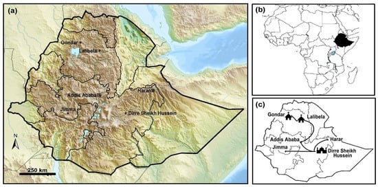
Figure 1.
(a) Map of Ethiopia showing topography with locations mentioned in the text. (b) Africa with Ethiopia marked in black. (c) Major pilgrimage routes to Dirre Sheikh Hussein from Jimma, Addis Ababa (and nearby Adama) and Harar. Route from Addis Ababa to Lalibela and on to Gondar. Notes: (a) Basemap https://en.populationdata.net/maps/ethiopia-topographic/ (accessed on 5 November 2023).
Pilgrimage takes place during short time windows (i.e., often a few months), which makes the climates related to pilgrimages amenable to study using many of the classic tools of climatology that have been applied to examining the impact of climate change on agriculture [21], ecosystems [22], disease [23] and cultural landscapes and heritage [3].
1.1. Pilgrimage to Dirre Sheikh Hussein
The Dirre Sheikh Hussein heritage site [24] is set in semi-arid lowlands in a remote part of the East Bale Zone of the Oromia region ~610 km from Addis Ababa. The sanctuary (Figure 1a) was established in the 10–12th century by the Islamic saint Sheikh Nur Hussein. He founded this important religious complex as part of his crucial role as a Muslim missionary, spreading Islam among the Arsi Oromo people of southern Ethiopia. The site has an area >19,000 ha, with an inner core of 880 ha. There are 11 historic structures and 12 gates in the white stone walls and fences of the compound [25]. The oldest building is the Zuqtum Mosque, built by Nur Sheikh Hussein and his students. In addition, there are five major tombs and some substantial mosques (18th–19th century), along with festive places and ceremonial courtyards, and water harvesting ponds including the largest, Haru Luku, built by Sheikh Hussein. About 5 km distant is Ayinagegn, a sacred cave, once a dwelling place of Sheikh Hussein. Dirre Sheikh Hussein has long been associated with Islamic learning and the religious culture of southern Ethiopia, a place where people can express a mixture of Islamic and traditional beliefs (Muda), particularly during the annual religious festivals. As such, it has become the destination for many pilgrims.
The pilgrimage to the shrine at Dirre Sheikh Hussein is a notable Islamic journey, sometimes seen to be almost as significant as the Hajj to Mecca. Devotees of Sheikh Hussein go on pilgrimages to his shrine as frequently as they can. The religious importance of the shrine has made it a place of pilgrimage, especially to celebrate the birthday of Sheikh Hussein (Zara) in January. A further celebration occurs at the end of the Muslim year with a great feast, of which the date changes each year depending on the lunar calendar.
The pilgrimage was especially popular during the period of Emperor Haile Selassie (1930s–mid-1970s) and was undertaken by about 100,000 people in 1971 [26]. It was less popular because of restrictions during the Derg regime (Provisional Military Government of Socialist Ethiopia) from 1974 to 1987, but gradually grew to an estimated 500,000 people in 2007. Over the last decade, although the number of tourists has increased, the number of pilgrims declined due to the changing influence of religious tolerance [27,28,29], recent civil conflict, drought, decline in livestock and crop production [30]. Times of improved agricultural economy generally see the regional community with more disposable income to finance transport and contribute to other related costs associated with the pilgrimage. The number of pilgrims was estimated at 200,000 in 2018.
Like many great pilgrimages, the journey to Dirre Sheikh Hussein is long and arduous. Travel distances of 1600 km are not unusual, and in many cases, pilgrims are on foot or ride mules, horses, donkeys or camels. In the 1970s, travel could take up to six months, with communities along the routes providing hospitality to the pilgrims as they passed through different localities. The pilgrims carry a range of cultural objects, such as the Ulee Sheikh Hussein (Y-shaped sticks) that identify them, so they remain unmolested even during times of war. Additionally, the Qulu, a cup made from a gourd, is often carried along with the Dibbee, a musical instrument made from a local tree.
Recently, the number of pilgrims who travel by foot has decreased due to the availability of public transport, but some pilgrims still choose to walk to Dirre Sheikh Hussein (Figure 2a,b), as is the case with other iconic pilgrimages [31]. Wealthier or international travellers can make their way from Haile Selassie Airport (Addis Ababa) through to Dirre Sheikh Hussein via Robe Airport, although it is more than 100 km to the southwest. Infrastructure that might encourage tourism to the shrine tends to be poor [32], and the airport at Dirre Sheikh Hussein was damaged during the Ethiopian-Somali war (1977–1978) so it is no longer functioning, although there has occasionally been talk of reconstructing it.
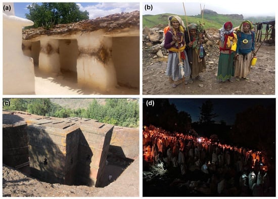
Figure 2.
(a) Interior of the shrine compound at Dirre Sheikh Hussein. (b) Pilgrims on the main road from Robi to Addis Ababa in August 2022. They were returning to their home in Butajira town in southern Ethiopia on foot, a journey of more than 500 km. Note that they carry Ulee Sheikh Hussein (Y-shaped sticks). (c) Biete Ghiorgis, the rock-hewn House of St. George. (d) Christmas vigil at Lalibela, with prayers at Emmanuel Church in honour of the Virgin. Photograph: (a,b) author H.G.T., (c) author J.R., and (d) Tanjagari–CC BY-SA 4.0.
1.2. Pilgrimage to Lalibela
Lalibela is in the Western Highlands of Ethiopia, and is famous for its 11 churches carved from the rock, a unique approach to construction. This, along with the historical significance of the site, led to the ensemble being recognised as a UNESCO World Heritage Site in 1978. Traditionally, the churches were thought to be built under the direction of King Gebre Mesqel Lalibela who reigned from 1181 to 1221, although legend has it that angels helped build the churches at night, which adds to a sense of divine intervention and mystery. Biete Giorgis (House of St. George) is the best known and most recent of the structures (Figure 2c). The town of Lalibela has an important religious significance for the Ethiopian Orthodox Church and bears an aura of devotion and spirituality, making it a unique and sacred destination. The churches are believed to possess miraculous healing powers, so they are visited by many pilgrims who seek their blessing. Pilgrims travel to Lalibela from within Ethiopia and neighbouring countries. It is a growing destination for religious heritage tourists interested in experiencing the religious and historical significance of the site. Although popular throughout the year, the key celebrations at Lalibela are Christmas or Genna, celebrated on 7 January, Timket (Epiphany), which takes place in January, and Meskel (Finding of the True Cross) in September. At these times, large numbers gather in Lalibela to attend the festivities and religious services.
Traders line the road from the town to the churches. The traditional ceremonies involve a vigil through Christmas Eve (Figure 2d). At sunrise on 7 January, Christmas celebrations centre around Bete Maryam (House of Mary) with 2–3 h of hymns and chanting. There are many weddings on Ethiopian Christmas Day in Lalibela, when couples become married to God. Lalibela is also known for its holy water that is believed to help spouses conceive their first child. By Christmas afternoon, while some pilgrims sleep or continue to celebrate, many have already started their journey home. Epiphany or Timket, which celebrates the baptism of Jesus, can occur at an artificial River Jordan in Lalibela, although Gondar (~350 km by road to the northwest) is perhaps the most important location for this ceremony, where it takes place at Fasilides’ Bath on 19 January.
The pilgrimage to Lalibela takes place for major festivals, with locals claiming that around a million people arrive at Christmas. Official figures focus on tourists, so these figures are smaller, suggesting 20,000–50,000 believers during major celebrations [33]. The total number of domestic tourist arrivals (as distinct from pilgrims) showed an increase from 6784 to 15,492 in the five year period 2008–2012. The number of international tourist arrivals also reflected a tangible increase from 21,641 in 2008 to 35,437 in 2012 [34]. In 2022, Lalibela was also a site of civil unrest, and since COVID-19, tourism has suffered [35].
1.3. Weather
The climate of Ethiopia [36] covers a wide range of Köppen classes (Figure 3a), with weather in mountainous regions presenting a challenge to pilgrims, particularly for those pilgrims who come from lowland areas, and must cross the Highlands. Many pilgrims from the Jimma Region must travel near Bale Mountains National Park (Mt. Tullu Dimtu is 4377 m). Here, temperatures vary widely, and on the plateau, daytime temperatures are usually around 10 °C with strong winds. At higher elevations, frosts are common at night. The challenging climate is evident in the faces of elderly pilgrims in the mountains (Figure 1b). The timing and duration of pilgrimages will be location- and site-specific, but depends on the distance pilgrims must travel and the mode of transport, which might be on foot, by donkey, car or plane. The climate conditions can make the journey arduous for the pilgrims; high temperatures can cause heat stress for those without access to shade, persistent rain can make mountain roads vulnerable to landslides, and intense thunderstorms can affect air traffic.
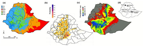
Figure 3.
(a) Köppen climate map of Ethiopia, adapted from Adam Peterson’s map of Ethiopia. (b) December frost probability [37]. (c) January rainfall map [38]. (d) Key pilgrimage routes.
The classic routes to Dirre Sheikh Hussein take pilgrims from Addis Ababa (or nearby Adama) and may proceed through Robi or Seru. Routes from Harar in the north proceed via Daro Labu to the shrine. Although both these routes might mean that pilgrims face a chance of frost at night, it is the popular route from Jimma in the west that takes pilgrims over mountains with a high probability of frost and rain, which makes travel difficult, as shown in Figure 2b. The routes to Lalibela can take pilgrims north along the Awash Valley, but winter conditions are generally milder as they move away from Addis Ababa and north beyond Debre Birhan, the coldest city of Ethiopia (~120 km northeast of Addis Ababa).
1.4. Aims and Hypothesis
The tangible heritage at Dirre Sheikh Hussein is in a region susceptible to environmental change [24], so it has been the focus of some recent conservation efforts. The churches at Lalibela are better known internationally and have also been addressed in conservation programmes. Sadly, some of the restoration efforts have had undesired effects and led to difficulties between funders, conservation professionals and the local stakeholders [39]. The expanding religious and eco-tourist market and problems in achieving this sustainably [34,39] have also added to risk at the sites. Although there are some studies of climate effects at Dirre Sheikh Hussein, which is in a region susceptible to environmental change [24], and Lalibela [40], these remain limited. However, this study focuses on the pilgrims rather than the material heritage, so it considers the effect of a changing climate on their travels and experiences at these sacred sites. Significantly, the pilgrimages to Dirre Sheikh Hussein and Lalibela both take place at the coldest time of year, which hitherto has provoked less interest among those studying the effects of climate in pilgrimages, that are typically summer occurrences [17,18,20].
2. Materials and Methods
Meteorological parameters were chosen to capture the challenges that pilgrims may face in terms of extremes in temperature and rainfall: low temperatures makes sleeping at night difficult, while high temperatures can mean that walking during the day is exhausting. Rainfall events can hinder both pilgrims travelling by foot and by car, as paths and roads are muddy, and in extreme cases, impassable. To capture these challenging conditions, we use two temperature parameters and one rainfall parameter:
- (i)
- Minimum daily temperature (°C), the averaged (mean) minimum daily temperature for a given period;
- (ii)
- Maximum daily temperature (°C), the averaged (mean) maximum daily temperature for a given period;
- (iii)
- Rain days above 1 mm, the number of days where rainfall exceeds 1 mm per 30 days.
Furthermore, as pilgrims do not experience an average climate, but rather the particular weather that occurs during their travels, the persistence of conditions is investigated. It may be that days of persistent rain or successive wet or hot or cold days will be especially troublesome. This has been examined by determining the weather on successive days.
2.1. Meteorological Observations
The parameters were calculated using the hourly 2 m surface temperature from ERA-5 reanalysis and the total daily rainfall from Climate Hazards Group InfraRed Precipitation with station data (CHIRPS) Version 2 [41], to capture observed meteorological conditions across Ethiopia. Both datasets were interpolated onto a common 0.25° × 0.25° grid. Additional analysis was undertaken for the three climate parameters for the nine (3 × 3) grid cells centred on the locations of Addis Ababa, Lalibela and Dirre Sheikh Hussein (Figure 3d).
2.2. Modelled Data
In many fields, such as climate and environmental sciences, climate models provide a useful tool for assessing future scenarios. Climate models are likely to provide (i) lengthy datasets without gaps that can frequently occur in manual observational records [42], and can provide (ii) raw climate data that can be used to construct parameters that relate to heritage impacts [5].
Successfully representing Ethiopian climate conditions using GCMs can be challenging, due to issues with capturing precipitation processes and the effect of complex orography on GCMs [43,44]. Richards and Brimblecombe [45] found that an ensemble of three CMIP6 GCMs (CMCC-ESM2, HadGEM3-GC31-MM and NorESM2-MM [46]) are effective in reproducing three parameters: minimum daily temperature, maximum daily temperature and rain days above 1 mm for the period 1984–2014 by comparing the parameters generated using the ERA5 and CHIRPS to the CMIP6 datasets for this period. Therefore, the parameters were also calculated using CMIP6 GCMs [47] to explore the effect of future climate scenarios on pilgrimage. The Centre for Environmental Data Analysis (CEDA) archive was used to obtain daily 2 m surface temperature and precipitation data for the historical period (CMIP experiment) and future projections. The results were calculated using the CMCC-ESM2, HadGEM3-GC31-MM and NorESM2-MM CMIP6 models [47], using only model runs of the variant r1i1p1f*. All models were interpolated to a common 1° × 1° grid to facilitate model comparison.
We calculated the three climate parameters for the Bega season in the recent past, 1984–2014, and mid-century, 2035–2065, to assess the extent of change under a high emission (SSP585) scenario. The time frame of 1984–2014 is chosen to align with the climate model experimental year runs and is the most recent 30-year period included in the historic model experiments. The SSP585 scenario was chosen to illustrate a worst-case scenario for climate change impacts on pilgrimage in Ethiopia. The parameters were calculated for the period 1 December to 15 February to cover the various durations of pilgrimages that might be undertaken during the Bega season. We also calculated results for the shorter period of 14 days from 1 to 14 January, but as little significant difference was found between the results over different durations, these are included in the Supplementary Material (Figure S1). The HadGEM3 model operates on a 360-day annual timescale, but results from both this study and earlier work [45] show that this difference does not significantly affect the results. For each 30-year period, the mean and the 10th (minimum daily temperature) or 90th percentile (maximum daily temperature and rain days above 1 mm) were calculated. We use percentiles to illustrate climate extremes that pilgrims may experience.
2.3. Statistics
In our statistical analysis of the meteorological data, we have often adopted non-parametric methods, as distributions are often skewed. Box-and-whisker plots represent the central tendency and range. The boxes show the lower and upper quartiles, with the median denoted by the central line in the box and a cross to represent the arithmetic mean. The whiskers show the range of all other points, except those that are deemed as outliers. An outlier is considered any value that lies over 1.5 times the interquartile range below and above the quartiles. The Kendall τ statistic was used to express rank correlation in bivariate data sets.
3. Results and Discussion
3.1. Current Climate
The weather during Bega has some characteristics that make pilgrimages convenient. It is a relatively cool and dry season. The output from the observed data for the minimum and maximum daily temperatures and precipitation is plotted in Figure 4. The three climate parameters showed no significant trend with time over the 30-year period in Addis Ababa, Lalibela or Dirre Sheikh Hussein (Kendall τ, p > 0.05). The area around Addis Ababa has the lowest temperatures with occasional values falling to nighttime minima below zero. The average nighttime temperatures in Addis Ababa are 6.61 °C, with a 10-percentile value of 3.78 °C (Figure 4). Furthermore, in Addis Ababa, the 30-day periods during Bega have some 16 days when temperatures are likely to be <5 °C and a day of similarly low temperatures immediately adjacent.
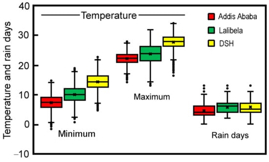
Figure 4.
Box-and-whisker plots of the minimum daily temperatures, maximum daily temperatures and the number of rainy days (>1 mm) for the 77-day period in the Bega season for the areas around Addis Ababa, Lalibela and Dirre Sheikh Hussem, for the period 1984–2014.
The area around Debre Birhan (elevation 2840 m), about 110 km northeast of Addis Ababa, is the coldest of Ethiopian cities. It lies on the route from the capital to Lalibela, and nights with sub-zero temperatures are not uncommon; over the past decade, temperatures as low as −7.8 °C have been recorded (7 January 2017) [48]. The analysis of the observed data from the grid cell immediately to the southwest of Debre Birhan shows an average nighttime 6.22 °C and a 90-percentile of 3.48 °C across the 77 days for the period 1984–2014. Here, there are likely to be as many as 22 days in a month where temperatures are <5 °C. Such cold spells are likely to be especially troublesome for pilgrims trying to find adequate shelter at night.
Although Lalibela is not as cold, nighttime temperatures to the southeast of Lalibela are low, with an average of 7.1 °C (Figure 4). Dirre Sheikh Hussein has the highest maximum temperatures in the Bega season, with an average of 29.1 °C for the 77 days, with a 90-percentile of 31.4 °C (Figure 4)—temperatures uncomfortably hot for walking. Spells of hot weather are likely at Dirre Sheikh Hussein, where in a month, there may be 15 days with daytime temperatures > 30 °C and also a day with similarly high temperatures immediately adjacent.
The observed data also show rainfall in Addis Ababa that averages at 52.6 mm for the Bega season between 1984 and 2014. Wet weather is likely to be persistent in the area around Addis Ababa, despite Bega being the dry season. About two spells (two or more days) of days of rain in excess of 1 mm are likely in the 77-day Bega season used in our analysis. This could make the pilgrims’ journeys uncomfortably wet, particularly if the rain days are consecutive. This would also be true for the mountains (Figure 3c) to the southeast, which are traversed by pilgrims making their way from Addis Ababa to Dirre Sheikh Hussein, or from Jimma to Dirre Sheikh Hussein (another very popular route). While the Bega season is generally dry, there are occasional heavy falls of rain; notable was a very wet day with 75.2 mm of rain on 11 October 2022 in Dilais, a market town in southern Ethiopia [49].
3.2. Future Projections
Figure 5a shows the average minimum temperature each day for the recent past over the years 1984–2014 and for the middle of this century, 2035–2065. The minimum daily temperatures are lowest in the highland regions and higher in the southeastern areas. Minimum daily temperatures are projected to increase by the middle of the century, with the greatest increase in the northeastern region (Figure 5b,c). The highland regions of Ethiopia are projected to no longer experience average minimum temperatures of below 10 °C mid-century. This will mean that for sites such as Lalibela, cold nights will become increasingly rare during the Bega season. Even in the extreme cold years (the coldest 10% of years), average temperatures show a warming trend with minimum temperatures, even in the highlands, which are unlikely to fall below 10 °C (Supplementary Materials, Figure S2). As these are average temperatures, temperatures on individual nights may be notably lower than the average values, but this indicates that cold nights and frost events are likely to become less common in the future.
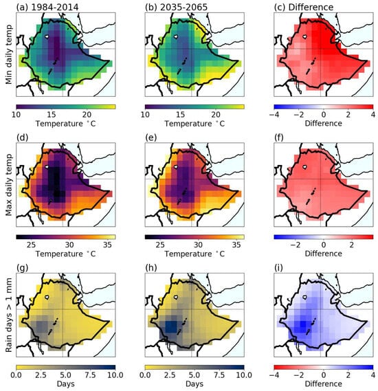
Figure 5.
The mean modelled outputs for (a–c) minimum daily temperature (°C), (d–f) maximum daily temperature (°C) and (g–i) rain days >1 mm for (a,d,g) the recent past: 1984–2014, (b,e,h) mid-century: 2035–2065 and (c,f,i) the difference between the future and past scenarios. All parameters are calculated for the period 1 December to 15 February.
Figure 5d shows the average maximum daily temperature for the recent past (1984–2014), with the highest temperatures in the east and lower maximum temperatures in the Highlands. In line with the trend in minimum daily temperatures, future maximum daily temperatures are projected to increase across all of Ethiopia in the near future, 2035–2065, with an almost homogenous increase of 2 °C across the whole country (Figure 5e,f). The extremes are also projected to increase. In the recent past, extreme hot years (90th-percentile) were between 0.25 and 0.75 °C warmer than the average year. However, by mid-century, these hot years are likely to be more than 1 °C above the average year. This suggests that in the future, pilgrims are likely to experience some unpleasantly hot days when walking to sites in the eastern regions, such as on the Dirre Sheikh Hussein pilgrimage.
Figure 5g shows the average number of days with more than 1 mm of rain for the recent past over the years 1984–2014. The number of these rain days is greatest in the southwest of the country and is projected to increase by four days in the middle of the century (Figure 5h,i). There is a general increase in wet weather across the country, which could make conditions unpleasant for pilgrims, particularly if rain days were consecutive. The difference in years with an extreme number of rain days is also projected to increase mid-century, with extreme wet years in the southwest seeing more than four extra rain days per month than on average (Supplementary Materials, Figure S2).
The current rainfall in the area around Addis Ababa during the 77-day pilgrimage period is ~50 mm, with about ~7 rain days each year (~3 rain days in a month). Over the 77-day period, there are typically three spells where rainfall comes on consecutive days. In the future, the number of such rainy spells is likely to double. This will also increase in the near future in the area to the southeast of Addis Ababa. Such increases will also be felt on the route from Jimma to Dirre Sheikh Hussein, and suggest that the travellers here will have to face more persistently wet days.
4. Conclusions
This study was able to use climate variables to assess changing pressures on pilgrimages as intangible heritage. However, weather experienced by the pilgrims is not the average, and travel difficulties are more likely to be affected by extreme conditions or spells of consistently hot or cold weather. Thus, well-tuned parameters need to be considered when evaluating the effects on intangible heritage, which has some parallels of heritage climates developed for material heritage. General increases in temperature make the occurrence of frosts and cold weather less likely; in particular, the mountain passes will have more temperate conditions. However, the number of hot days (>30 °C) may make travel around Dirre Sheikh Hussein less pleasant for pilgrims, who will need to rest or seek shade and carry more water. The long-term management of religious tourism will need to consider the wetter climates in the southern Highlands. Also, more thought will be needed over providing shelters and accommodation at Dirre Sheikh Hussein that has to account for the higher temperatures likely to occur mid-century. Future research (i) will hopefully be able to make use of modelled outputs at higher resolution, and especially rainfall projections, to account for a varying topography and convection processes; (ii) will further assess the robustness of projections by model inter-comparison; and (iii) could consider the comfort levels experienced by pilgrims in a changing climate. As social practices are increasingly at risk in a changing environment, it is important that climate impacts on intangible heritage can be properly evaluated.
Supplementary Materials
The following supporting information can be downloaded at: https://www.mdpi.com/article/10.3390/heritage7010004/s1, Figure S1: The mean modelled outputs for (a–c) minimum daily temperature (°C), (d–f) maximum daily temperature (°C)and (g–i) rain days >1 mm for (a,d,g) the recent past: 1984–2014, (b,e,h) mid-century: 2035–2065 and (c,f,i) the difference between the future and past scenarios. All parameters are calculated for the period 1 to 15 January. Figure S2. The extreme modelled outputs for (a–c) minimum daily temperature (°C), (d–f) maximum daily temperature (°C) and (g–i) rain days >1 mm for (a,d,g) the recent past: 1984–2014, (b,e,h) mid-century: 2035–2065 and (c,f,i) the difference between the future and past scenarios. All parameters are calculated for the period 1 December to 15 February. (a–c) uses the 10th percentile and (d–i) uses the 90th percentile.
Author Contributions
Conceptualization, P.B. and J.R.; methodology, P.B. and J.R.; software, J.R.; investigation, H.G.T.; data curation, J.R.; writing—original draft preparation, P.B., H.G.T. and J.R.; writing—review and editing, P.B. and J.R.; visualisation, P.B. and J.R. All authors have read and agreed to the published version of the manuscript.
Funding
This research received no external funding.
Data Availability Statement
Available on reasonable request from J.R. and some oral history materials from H.G.T.
Conflicts of Interest
The authors declare no conflict of interest.
References
- Cacciotti, R.; Kaiser, A.; Sardella, A.; De Nuntiis, P.; Drdácký, M.; Hanus, C.; Bonazza, A. Climate Change-Induced Disasters and Cultural Heritage: Optimizing Management Strategies in Central Europe. Clim. Risk Manag. 2021, 32, 100301. [Google Scholar] [CrossRef]
- Sardella, A.; Palazzi, E.; von Hardenberg, J.; Del Grande, C.; De Nuntiis, P.D.; Sabbioni, C.; Bonazza, A. Risk Mapping for the Sustainable Protection of Cultural Heritage in Extreme Changing Environments. Atmosphere 2020, 11, 700. [Google Scholar] [CrossRef]
- Sabbioni, C.; Cassar, M.; Brimblecombe, P.; Tidblad, J.; Kozlowski, R.; Drdácký, M.; Sáiz-Jiménez, C.; Grøntoft, T.; Wainwright, I.; Ariño, X. Global Climate Change Impact on Built Heritage and Cultural Landscapes. In Proceedings of the International Conference on Heritage, Weathering and Conservation (HWC 2006), Madrid, Spain, 21–24 June 2006; pp. 395–401. [Google Scholar]
- Brimblecombe, P. Climate Myths. In Climate Change and Cultural Heritage; Lefevre, R.-A., Sabbioni, C., Eds.; Edipuglia: Bari, Italy, 2010; pp. 207–209. [Google Scholar]
- Richards, J.; Brimblecombe, P. Tuning and Effectiveness in Heritage Models. Heritage 2023, 6, 5516–5523. [Google Scholar] [CrossRef]
- Pörtner, H.-O.; Roberts, D.C.; Adams, H.; Adelekan, I.; Adler, C.; Adrian, R.; Aldunce, P.; Ali, E.; Ara Begum, R.; BednarFriedl, B.; et al. Technical Summary. In Climate Change 2022: Impacts, Adaptation and Vulnerability. Contribution of Working Group II to the Sixth Assessment Report of the Intergovernmental Panel on Climate Change; Pörtner, H.-O., Roberts, D.C., Tignor, M., Poloczanska, E.S., Mintenbeck, K., Alegría, A., Craig, M., Langsdorf, S., Löschke, S., Möller, V., et al., Eds.; Cambridge University Press: Cambridge, UK; New York, NY, USA, 2022; pp. 37–118. [Google Scholar]
- Simpson, N.P.; Clarke, J.; Orr, S.A.; Cundill, G.; Orlove, B.; Fatorić, S.; Sabour, S.; Khalaf, N.; Rockman, M.; Pinho, P.; et al. Decolonizing Climate Change–Heritage Research. Nat. Clim. Chang. 2022, 12, 210–213. [Google Scholar] [CrossRef]
- Dembedza, V.P.; Chopera, P.; Mapara, J.; Macheka, L. Impact of Climate Change-Induced Natural Disasters on Intangible Cultural Heritage Related to Food: A Review. J. Ethn. Foods 2022, 9, 32. [Google Scholar] [CrossRef]
- Higgins, N. Changing Climate; Changing Life—Climate Change and Indigenous Intangible Cultural Heritage. Laws 2022, 11, 47. [Google Scholar] [CrossRef]
- Orr, S.A.; Richards, J.; Fatorić, S. Climate Change and Cultural Heritage: A Systematic Literature Review (2016–2020). Hist. Environ. Policy Pract. 2021, 12, 434–477. [Google Scholar] [CrossRef]
- Adger, W.N.; Barnett, J.; Chapin, F.S.; Ellemor, H. This Must Be the Place: Underrepresentation of Identity and Meaning in Climate Change Decision-Making. Glob. Environ. Polit. 2011, 11, 1–25. [Google Scholar] [CrossRef]
- Brimblecombe, P.; Hayashi, M. Pressures from Long Term Environmental Change at the Shrines and Temples of Nikkō. Herit. Sci. 2018, 6, 27. [Google Scholar] [CrossRef]
- Brimblecombe, P.; Hayashi, M.; Futagami, Y. Mapping Climate Change, Natural Hazards and Tokyo’s Built Heritage. Atmosphere 2020, 11, 680. [Google Scholar] [CrossRef]
- Hall, C.M. Will Climate Change Kill Santa Claus? Climate Change and High-Latitude Christmas Place Branding. Scand. J. Hosp. Tour. 2014, 14, 23–40. [Google Scholar] [CrossRef]
- Harrison, K. Indigenous Music Sustainability during Climate Change. Curr. Opin. Environ. Sustain. 2020, 43, 28–34. [Google Scholar] [CrossRef]
- Tomatis, F. Analysis of Possible Repercussions of Climate Change on the Camino de Santiago Francés (“French Way”) as It Passes Throught Castilla y León (Spain). Rev. Interam. Ambiente Tur. 2020, 16, 202–216. [Google Scholar] [CrossRef]
- Yezli, S.; Khan, A.; Bouchama, A. Summer Hajj Pilgrimage in the Era of Global Warming: A Call for Vigilance and Better Understanding of the Risks. J. Travel. Med. 2019, 26, taz069. [Google Scholar] [CrossRef] [PubMed]
- Aleeban, M.; Mackey, T.K. Global Health and Visa Policy Reform to Address Dangers of Hajj during Summer Seasons. Front. Public Health 2016, 4, 242106. [Google Scholar] [CrossRef] [PubMed]
- Singaraj, M.A.A.; Phil, M.; Awasthi, D.K.; India, U.P.; Bhoi, T. Thermal Anomaly and Heat Index during Mecca Pilgrimage (1982–2010). EPRA Int. J. Res. Dev. 2018, 3, 1. [Google Scholar]
- Saeed, F.; Schleussner, C.F.; Almazroui, M. From Paris to Makkah: Heat Stress Risks for Muslim Pilgrims at 1.5 °C and 2 °C. Environ. Res. Lett. 2021, 16, 024037. [Google Scholar] [CrossRef]
- Nelson, G.C.; van der Mensbrugghe, D.; Ahammad, H.; Blanc, E.; Calvin, K.; Hasegawa, T.; Havlik, P.; Heyhoe, E.; Kyle, P.; Lotze-Campen, H.; et al. Agriculture and Climate Change in Global Scenarios: Why Don’t the Models Agree. Agric. Econ. 2014, 45, 85–101. [Google Scholar] [CrossRef]
- Scholze, M.; Knorr, W.; Arnell, N.W.; Prentice, I.C. A Climate-Change Risk Analysis for World Ecosystems. Proc. Natl. Acad. Sci. USA 2006, 103, 13116–13120. [Google Scholar] [CrossRef]
- Rohr, J.R.; Dobson, A.P.; Johnson, P.T.J.; Kilpatrick, A.M.; Paull, S.H.; Raffel, T.R.; Ruiz-Moreno, D.; Thomas, M.B. Frontiers in Climate Change–Disease Research. Trends Ecol. Evol. 2011, 26, 270–277. [Google Scholar] [CrossRef]
- Tola, H.G.; Brimblecombe, P. Environmental Pressures at Dirre Sheikh Hussein Sanctuary. Heritage 2022, 5, 2661–2672. [Google Scholar] [CrossRef]
- UNESCO Inscription UNESCO. Dirre Sheik Hussein Religious, Cultural and Historical Site. Available online: https://whc.unesco.org/en/tentativelists/5649 (accessed on 3 November 2023).
- Braukamper, U. Historicizing Sacrificial and Initiatory Systems in Ethiopia Initiating Change in Highland Ethiopia: Causes and Consequences of Cultural Transformation. By Dena Freeman. J. Afr. Hist. 2004, 45, 173–174. [Google Scholar] [CrossRef]
- Semu, K.T. Dynamics of the Cult of Sheik Hussein of Bale, Ethiopia: Its Course and Curse of the Extremists, a Historical Perspective. Ethiop. J. Soc. Sci. Humanit. 2016, 12, 63–101. [Google Scholar]
- Semu, K.T. The Culture of Accommodating Diversity Embedded in the Sufi Saint Cult of Bale, Ethiopia: A Historical Overview. J. Equity Sci. Sustain. Dev. 2022, 5, 29–45. [Google Scholar]
- Ta’a, T. Religious Beliefs among the Oromo: Waaqeffannaa, Christianity and Islam in the Context of Ethnic Identity, Citizenship and Integration. Ethiop. J. Soc. Sci. Humanit. 2012, 8, 87–111. [Google Scholar]
- Tesfaye, K.; Assefa, M. Climate Change, Climate Variability and Adaptation in Ethiopia. Available online: http://repository.smuc.edu.et/handle/123456789/2834 (accessed on 16 November 2023).
- Downie, D. Paris to the Pyrenees: A Skeptic Pilgrim Walks the Way of Saint James; Simon & Schuster: New York, NY, USA, 2013. [Google Scholar]
- Aman, A.; Mama, K. Potentials and Pitfalls of Dirre Sheik Hussein Religious and Cultural Site in Tourism Development, Ethiopia. J. Tour. Hosp. 2019, 8, 2167. [Google Scholar] [CrossRef]
- Jarzombek, M. Lalibela and Libanos, the King and the Hydro-Engineer of 13th-Century Ethiopia. Thresholds 2007, 34, 78–81. [Google Scholar] [CrossRef]
- Bayih, B.E. Potentials and Challenges of Religious Tourism Development in Lalibela, Ethiopia. Afr. J. Hosp. Tour. Leis. 2018, 7, 1–17. [Google Scholar]
- BBC. Ethiopia’s Lalibela Struggles as War and COVID-19 Keep Tourists Away. Available online: https://www.bbc.com/news/av/world-africa-61196572 (accessed on 20 November 2023).
- Fazzini, M.; Bisci, C.; Billi, P. The Climate of Ethiopia. In Landscapes and Landforms of Ethiopia; World Geomorphological Landscapes; Springer: Dordrecht, The Netherlands, 2015; pp. 65–87. [Google Scholar] [CrossRef]
- Takele, R. Frost Hazard Map of Ethiopia; Ultimate Solutions Consultancy PLC: Addis Ababa, Ethiopia, 2019. [Google Scholar]
- Newby, W.; Amrouni, K. Morphometric Analysis of Ethiopia Water Drainage Basins. Available online: http://gisedu.colostate.edu/webcontent/nr505/ethiopia2009/nr505_fall09_team13_Amrouni_Newby/index.html (accessed on 16 November 2023).
- Aseres, S.A. Key Stakeholders Roles and Tourism Development in Bale Zone. Int. J. Bus. Manag. Adm. 2016, 1, 2–4. [Google Scholar]
- Taye, B.; Viles, H.; Orr, S.A. Seasonality in Moisture Dynamics in the Walls of the Rock-Cut Churches in Lalibela, Ethiopia: Implications for Weathering. Int. J. Archit. Herit. 2022. [Google Scholar] [CrossRef]
- Funk, C.; Peterson, P.; Landsfeld, M.; Pedreros, D.; Verdin, J.; Shukla, S.; Husak, G.; Rowland, J.; Harrison, L.; Hoell, A.; et al. The Climate Hazards Infrared Precipitation with Stations—A New Environmental Record for Monitoring Extremes. Sci. Data 2015, 2, 150066. [Google Scholar] [CrossRef] [PubMed]
- Brimblecombe, P.; Richards, J. Moisture as a Driver of Long-Term Threats to Timber Heritage—Part II: Risks Imposed on Structures at Local Sites. Heritage 2022, 5, 2966–2986. [Google Scholar] [CrossRef]
- Dosio, A.; Jones, R.G.; Jack, C.; Lennard, C.; Nikulin, G.; Hewitson, B. What Can We Know about Future Precipitation in Africa? Robustness, Significance and Added Value of Projections from a Large Ensemble of Regional Climate Models. Clim. Dyn. 2019, 53, 5833–5858. [Google Scholar] [CrossRef]
- Richards, J.; Brimblecombe, P.; Engelstaedter, S. Modelling Temperature-Precipitation Pressures on African Timber Heritage. Int. J. Climatol. 2023, 43, 7447–7462. [Google Scholar] [CrossRef]
- Richards, J.; Brimblecombe, P. Ability of GCMs to Represent Climate during Pilgrimages in Ethiopia. Res. Sq. 2023. [Google Scholar] [CrossRef]
- Choi, Y.W.; Campbell, D.J.; Eltahir, E.A.B. Near-Term Regional Climate Change in East Africa. Clim. Dyn. 2022, 61, 961–978. [Google Scholar] [CrossRef]
- Eyring, V.; Bony, S.; Meehl, G.A.; Senior, C.A.; Stevens, B.; Stouffer, R.J.; Taylor, K.E. Overview of the Coupled Model Intercomparison Project Phase 6 (CMIP6) Experimental Design and Organization. Geosci. Model. Dev. 2016, 9, 1937–1958. [Google Scholar] [CrossRef]
- Addis Ababa National Meteorological Agency. NMS Annual Climate Bulletin for the Year 2017. Available online: http://213.55.84.78/bulletins/seasonal_climatic_bulletins (accessed on 16 November 2023).
- Ministry of Water and Energy. Addis Ababa MWE Annual Climate Bulletin for the Year 2022. Available online: http://213.55.84.78/daily_weather (accessed on 16 November 2023).
Disclaimer/Publisher’s Note: The statements, opinions and data contained in all publications are solely those of the individual author(s) and contributor(s) and not of MDPI and/or the editor(s). MDPI and/or the editor(s) disclaim responsibility for any injury to people or property resulting from any ideas, methods, instructions or products referred to in the content. |
© 2023 by the authors. Licensee MDPI, Basel, Switzerland. This article is an open access article distributed under the terms and conditions of the Creative Commons Attribution (CC BY) license (https://creativecommons.org/licenses/by/4.0/).