1. Introduction
The digitization of paleontological exhibits has revolutionized the field of natural heritage (NH) [
1,
2], providing new avenues with which to enhance the promotion and accessibility of natural history content. The digitization of movable natural history assets stored in museums follows a cycle of preparation, conversion, and access, with a focus on technological aspects and the standards used [
3]. By creating virtual representations of physical objects, commonly referred to as digital twins, researchers and museums aim to attract larger audiences and leverage innovative technologies and digital tools [
4,
5].
With advancements in technologies like laser 3D scanning and photogrammetry, capturing detailed three-dimensional information of paleontological exhibits within a museum has become possible. These technologies enable the creation of accurate and immersive digital replicas that offer numerous opportunities for research, education, and entertainment [
6,
7,
8]. In addition, 3D tangible representations of paleontological exhibits can offer more engaging experiences for museum visitors [
9]. However, digitization is not without challenges, including the lack of a national strategy and guidelines in some regions [
10].
To address the rising demand for personalized digital experiences, especially given the backdrop of the recent COVID-19 pandemic, the v-PalM project aims to develop a digital platform for virtual guidance and educational services at the Museum of Paleontology and Geology, hosted at the National Kapodistrian University of Athens
1. This platform will harness innovative information and communication technologies (ICT), including the development of mobile applications that utilize the digitization of content through 3D scanning devices.
This paper presents an enhanced methodology for the digitization of paleontological exhibits, following the methodology of Mallison and Wings [
11] in order to create digital twins that are suitable for various scenarios. The enhanced methodology will serve as a practical guide for researchers and museums interested in using digitization techniques to expand the reach and impact of natural history objects. The digitized replicas generated through this methodology not only facilitate research by providing detailed and accurate representations of physical paleontological exhibits but also offer enhanced educational experiences. Through interactive and immersive learning opportunities, these digital twins enable learners to engage with natural history exhibits in novel ways. Moreover, the availability of such digital replicas introduces new possibilities for entertainment, allowing individuals to virtually explore and interact with paleontological discoveries.
The rest of the paper is structured as follows:
Section 2 reviews related work on digital twins of paleontological exhibits.
Section 3 presents the v-PalM project and the materials and methods used;
Section 4 presents the proposed methodology. Finally, the discussion, conclusions, and future research points are given in
Section 5 and
Section 6.
2. Related Work
In recent years, the digitization of natural history exhibits and sites has gained significant attention due to its potential to preserve and disseminate knowledge about Earth’s past. Two prominent techniques utilized for this purpose are photogrammetry and laser scanning. Photogrammetry involves capturing and analyzing multiple photographs of an object or site to create a 3D model, while laser scanning employs laser beams to measure the shape and dimensions of objects with high precision. These methods have revolutionized the documentation and exploration of natural heritage, enabling virtual access, research, education, and entertainment experiences.
Numerous projects and applications have emerged, showcasing the effectiveness of photogrammetry and laser scanning in the realm of natural history digitization [
11,
12,
13,
14,
15,
16,
17,
18,
19,
20,
21,
22]. These initiatives have demonstrated the extensive array of possibilities and advancements within this field. For example, an exemplary project [
13] demonstrates the feasibility of using structured light scanners to capture field data and create high-resolution, interactive 3D models of at-risk natural history resources. Additionally, in a study involving toothed whales [
21], 3D landmark geometric morphometric data were used from the skulls of 60 out of 72 extant odontocete species and a well-supported phylogenetic tree to test whether size and shape variation are associated with ecological adaptations at an interspecific scale.
Furthermore, in Switzerland, a notable excavation study delves into the comparison and evaluation of various 3D scanning systems and photogrammetry approaches. The researchers meticulously examine the advantages, limitations, and practical considerations associated with each method, encompassing laser scanning, structured light scanning, and photogrammetric image-based modeling [
23]. Emphasizing the potential of these techniques in capturing accurate and detailed 3D data of natural sites, the researchers shed light on their capabilities. The article provides a comprehensive overview of the workflow employed and presents the outcomes of the data acquisition process, which encompass the generation of 3D models, point clouds, and orthophotos. Finally, we can find projects in the literature that collect natural history data through crowdsourcing techniques [
24] and projects that specialize in public data collection methodologies, particularly those related to paleontology [
25].
These examples highlight the growing interest and advancements in digitizing natural history through the application of photogrammetry and laser scanning techniques. By employing these technologies and creating accurate and simple methodology workflows, researchers, educators, and the general public gain unprecedented access to our shared past, fostering a deeper understanding and appreciation for our NH.
3. The v-PalM Project, Materials and Methods
3.1. Introduction
The v-PalM project (Advanced Tour and Education Services in the virtual Paleontology and Geology Museum) aims to create a platform for personalized digital tours at the Museum of Paleontology and Geology, utilizing cutting-edge technology (conversational agents, machine learning, personalized recommenders, implementation of gamification techniques, and content digitization). In response to the growing demand for immersive and interactive experiences, the project aims to leverage 3D scanning devices for content digitization. By capturing detailed three-dimensional representations of fossil exhibits, the platform aims to provide visitors with a remarkable level of realism and engagement. Through the integration of 3D technology, users are provided with the opportunity to explore and examine paleontological specimens from various angles, gaining a deeper understanding of their form and function. This innovative approach enhances the accessibility and educational value of the museum’s collections, enabling virtual visitors to appreciate the intricacies of fossil animals and plants from all over Greece and abroad. The utilization of 3D technology within the v-PalM platform works towards enhancing the museum experience, bridging the gap between physical and virtual visits, and offering an immersive introduction to the fields of paleontology and geology.
The Museum of Paleontology and Geology of the National and Kapodistrian University of Athens traces its origins back to the founding of the Physiographic Museum in 1835. Its collections consist of several thousand fossils from all over Greece, specimens from abroad, and historical representations of paleoenvironments, covering over half a billion years of geological history. Beyond its collection, the institution actively engages in scientific research and conducts paleontological excavations in numerous locations throughout Greece.
3.2. Materials and Methods
In every digitization endeavor, it is crucial to approach the heritage object or site with meticulous consideration. Our project is no exception, given the varying sizes of paleontological exhibits that require careful assessment. In order to address this, multiple visits to the Museum of Paleontology and Geology were carefully organized, where the v-PalM researchers provided valuable assistance in studying and determining the most suitable digitization strategy. However, certain challenges were encountered, such as:
Inadequate lighting in some instances, coupled with intense daylight illumination in others, posed its own set of obstacles.
The presence of glass cases posed challenges to the 3D scanning process for numerous paleontological exhibits, complicating the digitization efforts. The inability to remove these cases due to the fragility (of the cases and specimens) or weight added complexity.
Some exhibits were hanging from the ceiling at a great height, which made access to them extremely difficult. Photographing or scanning the surfaces between the exhibit and the ceiling required special techniques.
Some exhibits relied on metal supports (posts, brackets, etc.) for stability at certain angles, requiring special processing to remove these props from the 3D model.
Some exhibits were too close to fixed obstacles, such as a wall, and there was no space for the equipment (camera or scanner) to capture images.
Each exhibit had “dead zones”, places where it was impossible to photograph or scan. These points were usually cavities to which access was impossible, especially for the equipment. These dead spots created gaps in the final 3D model and required special processing.
In addition to conducting a technical study, it was imperative to consider the requirements of digitization quality. Certain instances necessitated the achievement of the highest possible level of digitization quality, particularly when dealing with historically significant locations within the site. To address this, special emphasis was placed on incorporating additional scanning locations and capturing more densely populated photographic documentation. These measures were taken to ensure a comprehensive and detailed digital representation that accurately captured the significance of the specific location within the site.
3.2.1. Materials
The selection of the paleontological exhibits was guided by various factors, including the physical tour provided to museum visitors, where specific paleontological exhibits are highlighted based on object significance and available tour duration. The following criteria were taken into account for determining the selection of specific paleontological exhibits per thematic area:
Rarity of the paleontological exhibits: Exhibits that are rare or unique hold priority for inclusion as 3D models.
Representativeness of the paleontological exhibits for the subject area: Exhibits that exemplify and represent the specific subject area are given consideration.
Importance of the excavation: Exhibits associated with significant excavations hold importance for both the museum and the country, influencing their inclusion.
Interest and appeal to the general public: Exhibits that generate curiosity and captivate the interest of the general public are considered for 3D modeling.
Sample authenticity: The authenticity of the exhibits is a determining factor for their inclusion as 3D models.
It is important to note that the selection of the paleontological exhibits may be subject to modification over time by the museum’s scientific staff. This allows the renewal of the digital exhibition, the incorporation of new scientific data, and the maintenance of visitor interest. The
Table 1 below presents the number of selected paleontological exhibits per thematic area.
In order to achieve accurate and detailed digitization of the selected paleontological exhibits, we employed two laser scanning technologies: the FARO M70 laser scanner and the Scan-in-a-box structured light scanner (PEP North Aegean, Greece). These scanners were chosen for their capacity to capture high-resolution 3D data with precision.
The FARO M70 laser scanner [
26] is mounted on a tripod and is capable of detailed scanning of large surfaces and objects at distances from 20 cm up to approximately 20 m. It can perform extremely dense scans, giving great detail in the texture of surfaces but also producing multi-GB volume files. It offers advanced functionality and flexibility, allowing efficient data acquisition. Its portability and ease of use made it suitable for capturing paleontological exhibits of various sizes within the Museum of Paleontology and Geology. In our case, the FARO M70 was the optimal choice for the large paleontological exhibits. It was also used to scan the museum area in case this was needed in a future application. The scanner utilizes laser technology to measure distances and generate point clouds, ensuring the capture of intricate details.
The
Scan-in-a-box structured light scanner [
27], known for its user-friendly interface, emerged as an excellent choice for digitizing smaller paleontological exhibits. The tripod-mounted scanner requires particularly careful handling and requires some prior preparation of the objects being scanned. The scanning process involves positioning the objects at a certain distance from the scanner and ensuring that the background behind them is uniform (a single color). A calibrating process of the device is then performed, followed by the scanning of the object from all its sides. To complete the scan, it might be necessary to rotate and reposition the object several times. Its compact design and versatility allowed convenient scanning in confined spaces, ensuring accurate representations of intricate objects. While it can render surface colors and textures correctly, its use is limited to small portable objects. The presence of an expert was needed to handle the exhibits with care, as they are particularly fragile.
Beyond laser scanning, photogrammetry played a significant role in our digitization process. We utilized both professional cameras and smartphones to capture a series of high-resolution photographs from multiple angles. Professional cameras, equipped with high-quality lenses and advanced settings, provided precise image acquisition. They proved particularly useful for capturing larger paleontological exhibits or objects with intricate details, where fine-grained textures were crucial for an accurate digital representation. Smartphones, equipped with increasingly sophisticated cameras, served as an effective alternative for capturing smaller paleontological exhibits or objects in less controlled environments. Their user-friendliness and portability enabled the swift capture of a wide range of objects, ensuring the efficiency of the digitization process.
3.2.2. Digitization Method and Tools
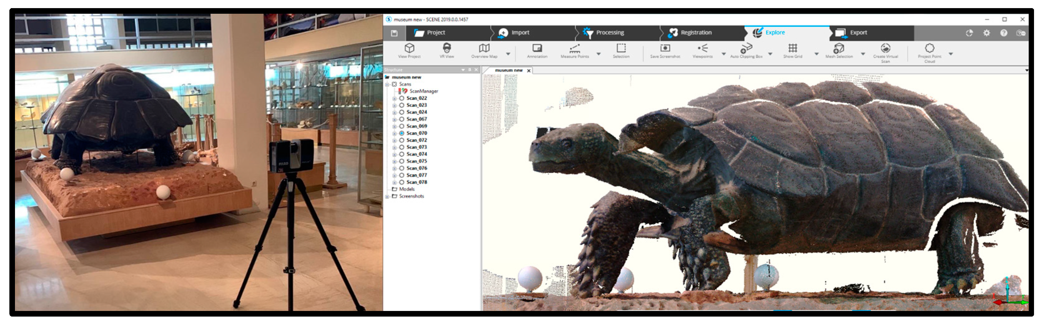
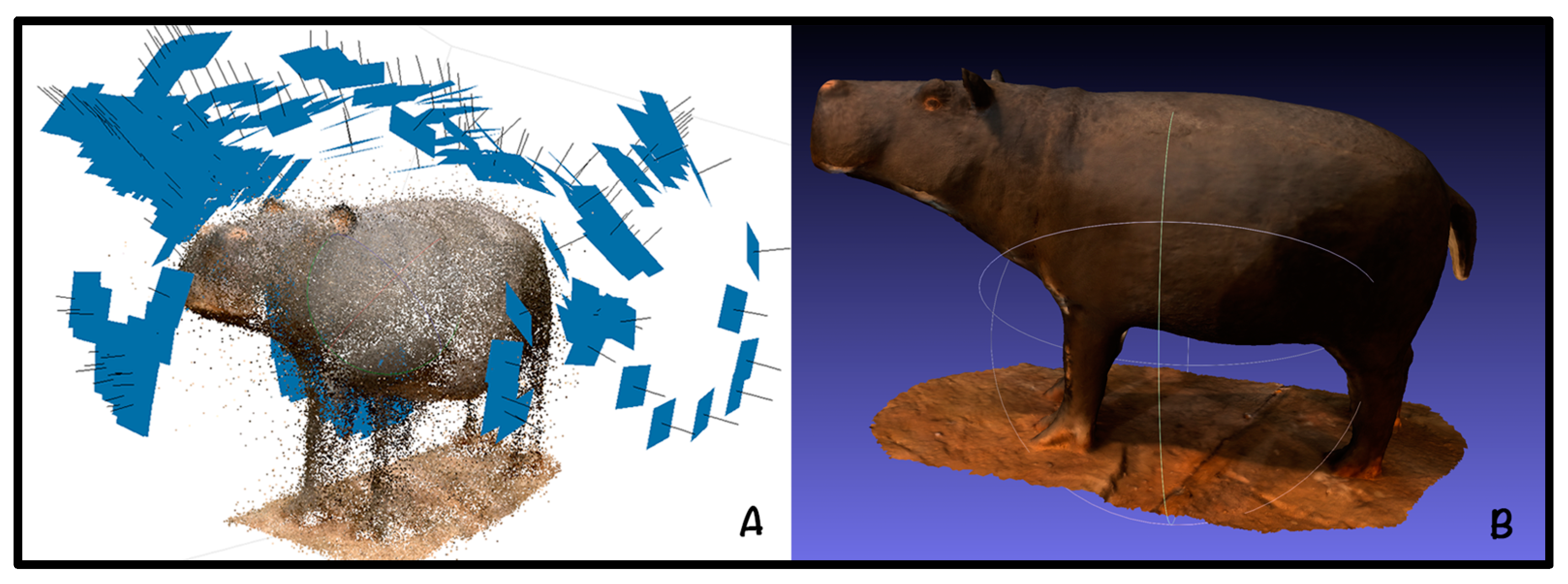
For the scanning of the large paleontological exhibits, the FARO Focus M70 laser scanner solution was employed (see Section Innovation in v-PalM Methodology). To ensure complete coverage, the scanner was strategically positioned at multiple points based on the designated placement plan. During the digitization process, approximately fifteen FARO scans were performed for each paleontological exhibit. Each scan required around 6 to 10 min to capture color point clouds and panoramic images. To align the different scans from different points, 6 reference white sphere pedestals with magnet plates were employed. The acquired data underwent processing using
FARO Scene software [
28], with registration performed for each site. Subsequently, meshes were generated and exported. The scanning process incorporated a high overlap to facilitate automatic data registration [
29]. The resulting 3D models were characterized by a well-defined structure and low-resolution textures (
Figure 1).
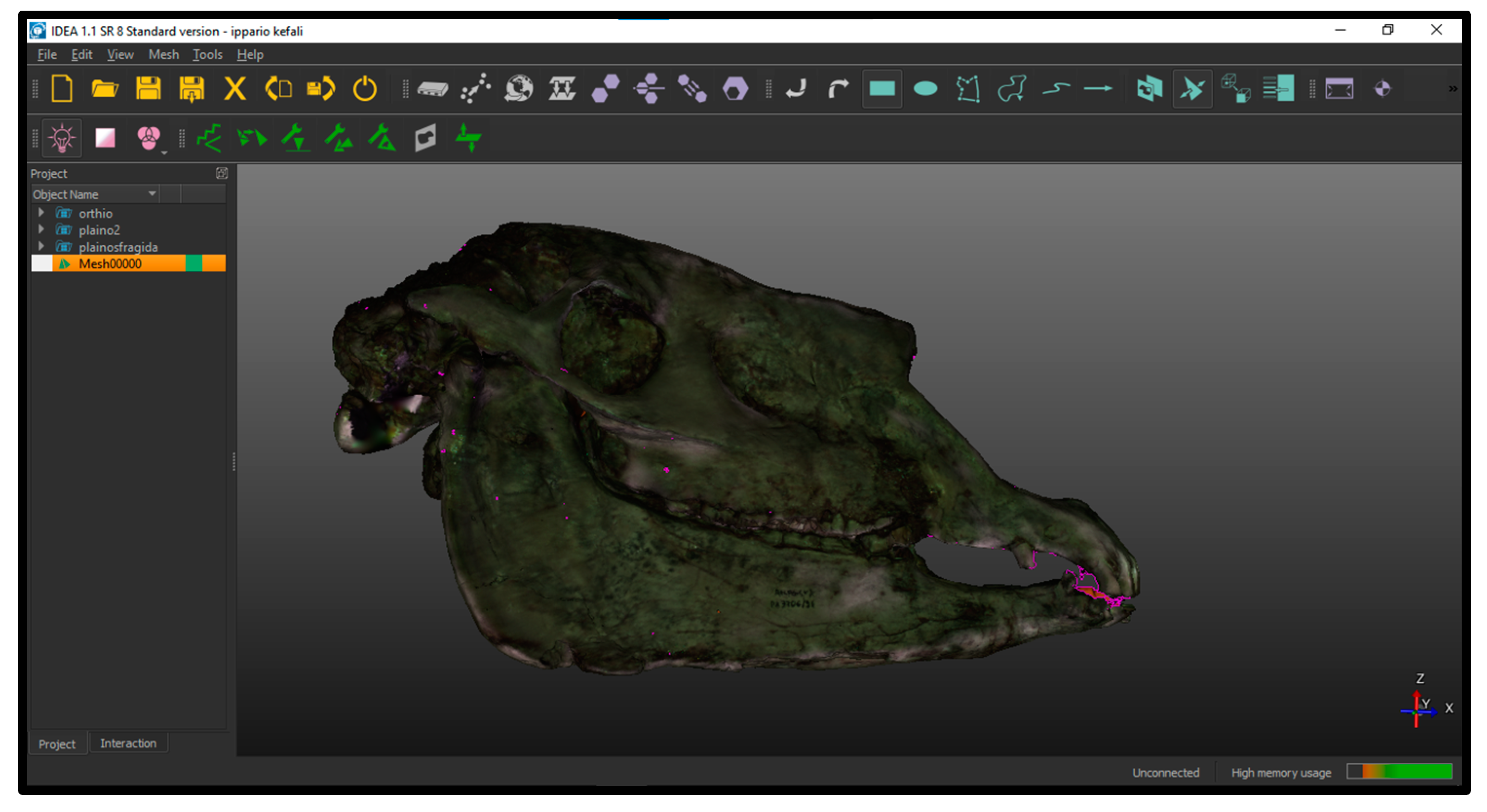
Regarding the smaller paleontological exhibits, the software utilized for scanning with
Scan-in-a-box is IDEA. This comprehensive software supports all stages of the digitization process for physical objects, including capturing range images and subsequently generating and refining their corresponding 3D models. IDEA software uses the active stereo vision structured light technology as an optical 3D scanning technique employed to capture the geometric details of a physical object. The object is illuminated by two cameras arranged in a stereo configuration, to capture images of the scanned part, and specialized software processes these images to generate two coded representations. Through the process of triangulation, a range image is derived, providing information about the object’s depth and shape. To obtain a comprehensive 3D model, it is necessary to capture the entire surface of the object using multiple frames. These frames are then aligned and transformed into a triangular mesh, resulting in a complete digital model of the object (
Figure 2 and
Figure 3). Τhe
Scan-in-a-box device was also chosen because it is a cost-effective and extremely flexible device for scanning small objects. The 3D models it produces are of high quality in terms of both geometry and texture. Also, the easy installation and configuration of the device during our visits to the museum site expedited the scanning of a significant number of objects with remarkable results.
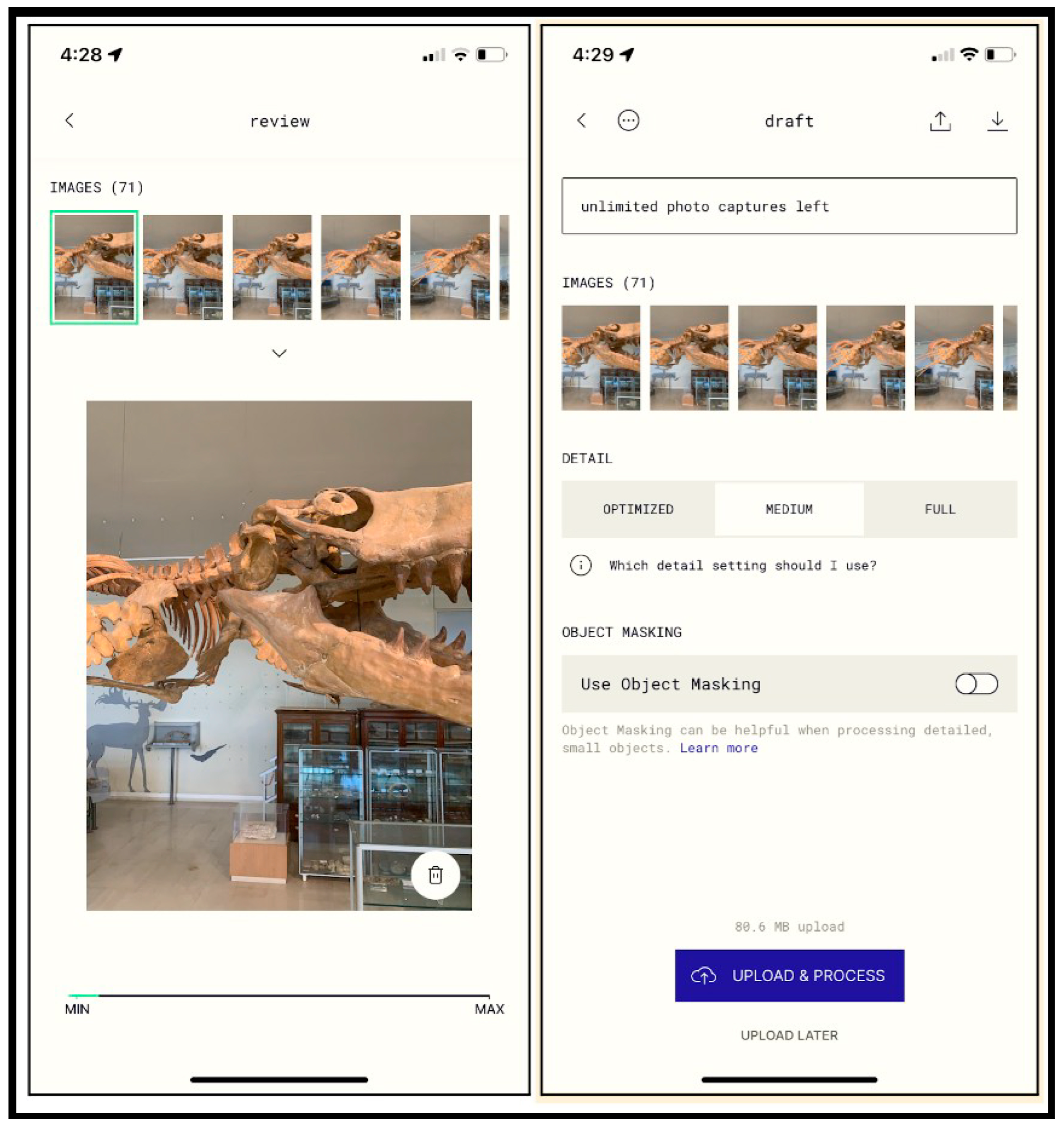
Finally, to capture the finer details of the paleontological exhibits, a photogrammetry approach was employed using a mobile phone (iPhone XR). Specifically, the
Polycam software was utilized to create a highly realistic 3D model [
30]. This was achieved by capturing a series of overlapping 2D photographs of the paleontological exhibits from various viewpoints. The software leveraged these photographs to measure and extract the necessary information, resulting in a photorealistic depiction of the paleontological exhibit in the 3D model [
31] (
Figure 4).
4. The v-PalM Methodology
To cater to mobile-centric applications of the v-PalM project, it is essential to combine all the laser scans and photogrammetry mesh creations into a unified, low-polygonal mesh. This unified mesh serves as a suitable format for such mobile applications. Additionally, the unification process enables the generation of high-resolution textures.
While the software used in each case is fully compatible with the respective devices employed to capture the digital information from the museum room, within the framework of the v-PalM project a methodology was developed, following the methodology of Mallison and Wings [
11], to assist in achieving the best possible results and in faithfully creating three-dimensional digital replicas of the project’s objects.
Primarily, the raw data from the 3D scanners were processed within their respective software packages, such as IDEA and FARO Scene. In our case, IDEA was chosen for small objects without many details, while FARO Scene was used for larger objects with complex details that required high-quality scanning. In both cases, Adobe’s Photoshop software was implemented to correct any mistakes in the object’s texture.
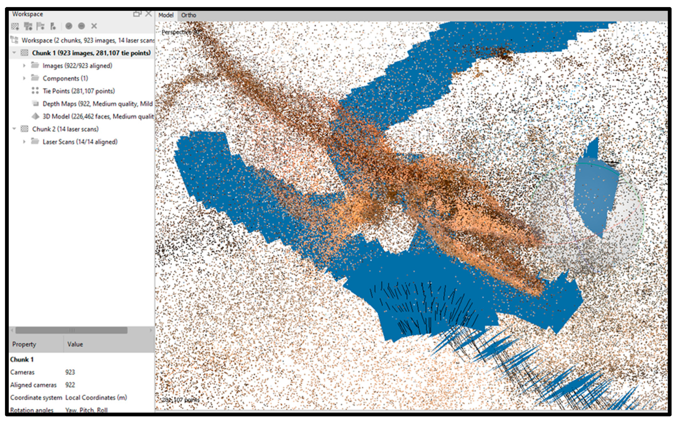
Agisoft Metashape is photogrammetry software that enables the creation of high-quality 3D models from a collection of 2D images or aerial photographs [
32]. By creating multiple chunks based on the group of photos taken from different devices or angles, we managed to create detailed point cloud and 3D model files that digitally recreated the natural history exhibits. The pivotal elements of this process encompassed the photogrammetric parameters and the necessary fine-tuned precision within the software’s algorithms. These adjustments aimed to transform the captured scene into precise and intricate 3D models. More specifically, the methodology developed for the project integrated methods for data alignment from different devices and types and included the following steps, as shown in
Figure 5 below.
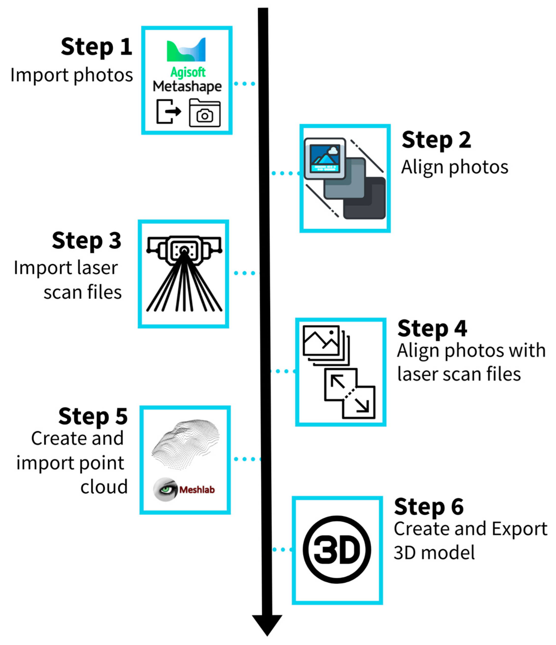
The v-PalM methodology (
Figure 5) integrates methods for data alignment from different devices and types and consists of 5 basic steps:
The initial step involves importing all the available photos from different devices (smartphones and cameras) into the Agisoft Metashape software. These photos, which can number as many as 1000 for a single object, are grouped for each object based on the shooting device, shooting angle, and shooting time into chunks. This separation strategy enhances the alignment process.
The second step concerns the alignment process, a time-consuming and computationally intensive task. Using different parameters, tests are conducted to achieve the most effective alignment of all photos, paying close attention to the accurate positioning of each photo. Factors such as position of the cameras, weather conditions, shadows, or minor distance variations of the photos result in severe difficulties during photo alignment.
In step 3, the laser scan files are imported. The laser scanner creates point clouds of high density and accuracy; this is vital for the depiction of the details of the textures and the geometry. Usually, there are several scans for each item, which need to be aligned within the scanner’s software. The subsequent aligned point clouds are then imported into Agisoft Metashape at the origin point (0, 0, 0) of the axes.
Step 4 represents the pivotal phase of the process, where the images must be aligned with the laser scans. Different settings and desired resolutions are tested in order to achieve optimal analysis of all the available data.
In step 5, the final point cloud—comprising points from the photos and scans—is imported into Meshlab. Unlike Agisoft Metashape software, which was used to combine data from multiple sources and create one point cloud file, Meshlab was utilized to refine the final point cloud file. This step includes tasks such as reducing the amount of polygons and removing the wrong points or filling the possible gaps in the file. The point cloud file undergoes cleaning processes to remove points, close gaps in the texture, and reduce the file size and point density accordingly, ensuring that the final file is small enough for use on mobile devices.
Finally, the 3D model is created and exported as an obj or stl file. The final 3D models consisted of thousands of polygons for the small artifacts to 3–4 million polygons for the larger artifacts (especially the ones that were created by multiple sources, including the laser scanner) (
Figure 6,
Figure 7 and
Figure 8).
In comparing our methodology with the methodology of Mallison and Wings [
11], we observe the following differences:
No markers for photography: We refrain from using markers during photography, as they are unnecessary for image alignment. This simplifies and expedites the process.
Single processing stage: Our approach processes the 3D models (cropping, cleaning up, closing gaps, etc.) only once along the procedure. The original data remain intact until the end, ensuring maximum precision. Processing occurs as the final stage and aims to preserve as much information as possible within the smallest possible file size, optimized for mobile devices. If higher resolution and more detailed models are needed for other types of applications, the last step can be easily repeated.
Variety of resources: Our methodology incorporates not only photographs, but also laser scans. While images—especially when they are taken using high-resolution professional cameras—can reproduce the colors and textures of objects very accurately, laser scans can capture the geometry of objects much more reliably. Lasers are unaffected by space brightness and shadows, offering important technical support for modeling.
Smartphone efficiency: A simple smartphone, instead of a potentially expensive and complex DSLR camera, is used. Therefore, no tripod is needed either. Equipped with the
Polycam app [
30], the smartphone can handle the photo shooting of hundreds of images automatically, while ensuring correct overlapping. The operator only needs to move slowly and capture photos seamlessly. Also, the immediate visibility of the results enables the operator to rectify any errors until the desired outcome is achieved.
As an additional method, we utilized advanced algorithms from the Meshlab software to rectify any errors, reconstruct any “gaps” in the 3D model, or minimize file size. Meshlab also includes a comprehensive set of tools for cleaning, repairing, and refining meshes obtained from 3D scanning or modeling processes. With this software, we performed tasks such as mesh simplification, texture mapping, smoothing, and measurement analysis.
Innovation in v-PalM Methodology
Scanning and photographing objects is a practice that has been implemented for many years, especially in the study and preservation of natural history. The innovations introduced by the v-PalM project are as follows:
Diverse media sources: This project used a variety of media sources, such as camera photos, cell phone photos, drone photos, laser scans from multiple scanners of various technologies, 360 images, and ready-made point clouds from prior work.
Media integration: We combined media from different sources using Agisoft Metashape Professional software to produce the final 3D models; it has certain algorithms that align different chunks of point cloud files. By generating point cloud files from each of the media sources used for a certain artifact, the Metashape software can align these files and produce one combined point cloud file that integrates structural information captured from different devices. Manual chunk positioning was, in some cases, necessary to increase alignment accuracy, while finding the optimal parameters of the alignment algorithm was a process of experimentation.
Media from different moments: This methodology uses data captured at different times. Photos and scans do not need to be taken on the same day or at the same time. Having all the data from a specific point in time makes the modeling process easier, but in the v-PalM methodology, it is something that can be overcome. Therefore, the flexibility in data collection, processing, and modeling allows adjustments (for example, we were missing a part of a cavity in an exhibit), enabling the generation of new data at another point in time.
Crowdsourcing: Images from internet users (social media for example) that clearly depict the object or add useful information to it could be utilized to enhance the detail in the final model.
The rendering of exhibits, objects, and spaces in three-dimensional form has involved many researchers in multiple projects. It is a demanding project and requires powerful computers to process the data. The resultant data files can be substantial (tens of GB per exhibit), and their management requires powerful processors, large RAM memory, and fast storage units. Advances in computer hardware, the software used, and the 3D scanning technologies are expected to simplify and accelerate 3D imaging.
5. Discussion
The digitization of museum paleontological exhibits has revolutionized the field of NH, offering new opportunities to promote and access natural history content. The creation of digital twins, which involves creating virtual representations of physical objects, has emerged as a means to attract larger audiences and leverage innovative technologies and digital tools. The utilization of advanced technologies such as laser 3D scanning, photogrammetry, and 3D design software enables the capture of detailed three-dimensional data of museum paleontological exhibits, leading to precise and immersive digital replicas. These digital twins have extensive applications in research, education, and entertainment, offering engaging experiences for museum visitors. However, the digitization process is not without its challenges. It is crucial to address these gaps and establish clear standards and frameworks for digitization efforts in the NH domain.
The v-PalM project serves as an exemplary initiative in the field, showcasing a methodology that can be adapted to diverse contexts and facilitating the creation of digital twins for purposes involving research, education, and entertainment purposes. Utilizing the existing resources, the provided materials will be used to identify scenarios and content that are suitable for a collection of games and educational initiatives centered around paleontology and geology. Each educational program will outline its thematic focus, title, educational objectives, implementation priority, target age group, and descriptive keywords. Leveraging the capabilities of the assisting agent, the users guiding online visitors through the tour can seamlessly select the most suitable educational program based on the visitor’s interests.
Furthermore, during the post-processing stage, several challenges were encountered, leading to valuable lessons learned from this work. Given the limitations of photogrammetry described earlier, the utilization of a laser scanner was preferred for larger paleontological exhibits. Careful analysis was conducted for each exhibit to determine optimal scanning locations that covered a maximum area with minimal scans. The issue of the varying illumination changes emerged as a substantial concern as the exhibits encompassed areas with diverse light conditions—ranging from external light sources (high illumination) to locations with reflected light (medium illumination) and even areas with minimal light (low illumination). These fluctuations in lighting posed challenges when attempts were made to capture accurate data, with some areas being over-illuminated while others were under-illuminated. To mitigate this, photographic documentation was employed during data capture to aid in the post-processing stage, while in many of the artifacts it was feasible to completely remove the illumination effect using our software algorithms. The illumination-related issues were addressed during post-processing, following the methodology described earlier in this work. Additionally, the presence of glass cases posed challenges to the 3D scanning process for numerous paleontological exhibits, further complicating the digitization process. To address this problem, additional photogrammetry methods were used with minimum light conditions to reduce the light refractions.
For smaller paleontological exhibits, the lighting settings with the Scan-in-a-box once again posed significant challenges that required careful consideration and adjustments during the scanning process. For instance, by relocating the Scan-in-a-box structured light scanner into a darker room and selecting appropriate angles and orientations, the reflections, shadows, and other lighting issues were minimized in the final scans.
6. Conclusions
In this paper, we present our endeavor to digitize the Museum of Paleontology and Geology at the Kapodistrian University of Athens, undertaken as part of the v-PalM project. Extensive visits to the museum were organized to study the paleontological exhibits that required digitization and to establish a suitable methodology for the process. The digitization efforts resulted in a substantial volume of data, necessitating post-processing to generate the final 3D models.
This paper highlights the importance of digitization in the museum context and presents the v-PalM project as a case study for the digitization of paleontological exhibits. The methodology outlined in this paper serves as a practical guide, providing insights and recommendations for researchers and museums embarking on similar digitization endeavors. The advancements in digitization technologies and the availability of digital twins present immense opportunities for the NH domain, fostering research, education, and public engagement. As technology continues to evolve, further exploration and research in this area will undoubtedly lead to new insights and innovations in the field of natural history digitization.
Author Contributions
Conceptualization, M.K., G.T. and J.A.; methodology, M.K., G.T. and J.A.; software, M.K., G.T., K.M. and J.A.; validation, M.K., G.T. and J.A.; formal analysis, M.K., G.T. and J.A.; investigation, M.K.; resources, M.K. and G.C.; data curation, M.K.; writing—original draft preparation, M.K., G.T., K.M. and J.A.; writing—review and editing, M.K., C.P. and G.C.; visualization, M.K.; supervision, E.K., S.S., C.P., A.T., A.Z., G.C. and S.P.; project administration, E.K., S.S., C.P., A.T., A.Z. and S.P.; funding acquisition, M.K. and G.C. All authors have read and agreed to the published version of the manuscript.
Funding
This work is conducted within the “Research and Innovation Synergies in the Region of Attica” Action, and is realized within the framework of ESPA 2014-2020, co-financed by Greece and the European Union (European Regional Development Fund), under the project with the title “Advanced Tour and Education Services in the virtual Paleontology and Geology Museum/v-PalM (ATTP4-0342153)” (award number: MIS 5185020).
Data Availability Statement
Not applicable.
Conflicts of Interest
The authors declare no conflict of interest.
References
- Wilson, R.J. Natural History: Heritage, Place and Politics; Routledge: London, UK, 2017. [Google Scholar]
- Lowenthal, D.; Olwig, K. (Eds.) The Nature of Cultural Heritage, and the Culture of Natural Heritage; Routledge: London, UK, 2013. [Google Scholar]
- Leifeste, A.; Stiefel, B.L. Sustainable Heritage: Merging Environmental Conservation and Historic Preservation; Routledge: London, UK, 2018. [Google Scholar]
- Mourtzis, D. Digital twin inception in the Era of industrial metaverse. Front. Manuf. Technol. 2023, 3, 1155735. [Google Scholar] [CrossRef]
- Blair, G.S. Digital twins of the natural environment. Patterns 2021, 2, 100359. [Google Scholar] [CrossRef] [PubMed]
- Minaroviech, J. Digitization of the Cultural Heritage of Slovakia. Combining of Lidar Data and Photogrammetry. Stud. Digit. Herit. 2017, 1, 590–606. [Google Scholar] [CrossRef]
- Wetherelt, A.; Cooper, J.P.; Zazzaro, C. 3D laser scanning and modeling of the Dhow heritage for the Qatar National Museum. In Second International Conference on Remote Sensing and Geoinformation of the Environment (RSCy2014); SPIE: Bellingham, WA, USA, 2014; Volume 9229. [Google Scholar]
- Scopigno, R.; Cignoni, P.; Callieri, M.; Ganovelli, F.; Impoco, G.; Pingi, P.; Ponchio, F. Using optically scanned 3D data in the restoration of Michelangelo’s David. In Optical Metrology for Arts and Multimedia; SPIE: Bellingham, WA, USA, 2003; Volume 5146. [Google Scholar]
- Trichopoulos, G.; Aliprantis, J.; Konstantakis, M.; Michalakis, K.; Caridakis, G. Tangible and Personalized DS Application Approach in Cultural Heritage: The CHATS Project. Computers 2022, 11, 19. [Google Scholar] [CrossRef]
- Ognjanović, Z.; Marinković, B.; Šegan-Radonjić, M.; Masliković, D. Cultural heritage digitization in Serbia: Standards, policies, and case studies. Sustainability 2019, 11, 3788. [Google Scholar] [CrossRef]
- Mallison, H.; Wings, O. Photogrammetry in paleontology—A practical guide. J. Paleontol. Tech. 2014, 12, 1–31. [Google Scholar]
- Falkingham, P.L.; Falkingham, P.L. Applying objective methods to subjective track outlines. In Dinosaur Tracks: The Next Steps; Indiana University Press: Bloomington, IN, USA, 2016; pp. 72–81. [Google Scholar]
- Adams, T.L.; Strganac, C.; Polcyn, M.J.; Jacobs, L.L. High resolution three-dimensional laser-scanning of the type specimen of Eubrontes (?) glenrosensis Shuler, 1935, from the Comanchean (Lower Cretaceous) of Texas: Implications for digital archiving and preservation. Palaeontol. Electron. 2010, 13, 11. [Google Scholar]
- Cunningham, J.A. The use of photogrammetric fossil models in paleontology education. Evol. Educ. And Outreach 2021, 14, 1–7. [Google Scholar] [CrossRef] [PubMed]
- De Reu, J.; Plets, G.; Verhoeven, G.; De Smedt, P.; Bats, M.; Cherretté, B.; De Maeyer, W.; Deconynck, J.; Herremans, D.; Laloo, P.; et al. Towards a three-dimensional cost-effective registration of the archaeological heritage. J. Archaeol. Sci. 2013, 40, 1108–1121. [Google Scholar] [CrossRef]
- Falkingham, P.L. Acquisition of high resolution three-dimensional models using free, open-source, photogrammetric software. Palaeontol. Electron. 2011, 15, 1–15. [Google Scholar] [CrossRef] [PubMed]
- Ntagiantas, A.; Manousos, D.; Konstantakis, M.; Aliprantis, J. Augmented Reality Children’s Book for Intangible Cultural Heritage through Participatory Content Creation and Promotion. Case Study: The Pastoral Life of Psiloritis as a UNESCO World Geopark. 2021. Available online: https://www.researchgate.net/publication/356478247_Augmented_Reality_children%27s_book_for_intangible_cultural_heritage_through_participatory_content_creation_and_promotion_Case_study_the_pastoral_life_of_Psiloritis_as_a_UNESCO_World_Geopark (accessed on 20 June 2023).
- Fau, M.; Cornette, R.; Houssaye, A. Photogrammetry for 3D digitizing bones of mounted skeletons: Potential and limits. Comptes Rendus Palevol 2016, 15, 968–977. [Google Scholar] [CrossRef]
- Liakopoulou, D.E.; Theodorou, G.E.; van Heteren, A.H. The inner morphology of the petrosal bone of the endemic elephant of Tilos Island, Greece. Palaeontol. Electron. 2021, 24, 1–11. [Google Scholar] [CrossRef] [PubMed]
- van der Geer, A.A. Uniformity in variety: Antler morphology and evolution in a predator-free environment. Palaeontol. Electron. 2018, 21, 1–31. [Google Scholar] [CrossRef] [PubMed]
- Vicari, D.; McGowen, M.R.; Lambert, O.; Brown, R.P.; Bianucci, G.; Sabin, R.C.; Meloro, C. Ecomorphology of toothed whales (Cetacea, Odontoceti) as revealed by 3D skull geometry. J. Mamm. Evol. 2023, 30, 475–491. [Google Scholar] [CrossRef]
- Pervolarakis, Z.; Zidianakis, E.; Katzourakis, A.; Evdaimon, T.; Partarakis, N.; Zabulis, X.; Stephanidis, C. Three-Dimensional Digitization of Archaeological Sites—The Use Case of the Palace of Knossos. Heritage 2023, 6, 904–927. [Google Scholar] [CrossRef]
- Siebke, I.; Campana, L.; Ramstein, M.; Furtwängler, A.; Hafner, A.; Lösch, S. The application of different 3D-scan-systems and photogrammetry at an excavation—A Neolithic dolmen from Switzerland. Digit. Appl. Archaeol. Cult. Herit. 2018, 10, e00078. [Google Scholar] [CrossRef]
- Moraitou, E.; Konstantakis, M.; Chrysanthi, A.; Christodoulou, Y.; Pavlidis, G.; Caridakis, G. Supporting conservation and restoration through digital media modeling and exploitation-the example of the Acropolis of Ancient Tiryns. In 2022 17th International Workshop on Semantic and Social Media Adaptation & Personalization (SMAP); IEEE: Piscataway, NJ, USA, 2022. [Google Scholar]
- Apostolakis, E.; Chatzipanteliadis, D. Evaluation of three structured light 3d scanners for the purpose of augmenting artisanal design and production of silversmithing artifacts in Ioannina. In 2022 7th South-East Europe Design Automation, Computer Engineering, Computer Networks and Social Media Conference (SEEDA-CECNSM); IEEE: Piscataway, NJ, USA, 2022. [Google Scholar]
- FARO Focus Laser Scanners. Available online: https://www.faro.com/en/Products/Hardware/Focus-Laser-Scanners (accessed on 20 June 2023).
- Scan-in-a-Box Structured Light Scanner. Available online: https://get3d.gr/en/product/scan-in-a-box/ (accessed on 21 June 2023).
- FARO® SCENE Software. Available online: https://www.faro.com/en/Products/Software/SCENE-Software (accessed on 25 June 2023).
- Moraitou, E.; Konstantakis, M.; Chrysanthi, A.; Christodoulou, Y.; Pavlidis, G.; Alexandridis, G.; Kotsopoulos, K.; Papastamatiou, N.; Papadimitriou, A.; Caridakis, G. Supporting the Conservation and Restoration OpenLab of the Acropolis of Ancient Tiryns through Data Modelling and Exploitation of Digital Media. Computers 2023, 12, 96. [Google Scholar] [CrossRef]
- Polycam Software. Available online: https://poly.cam/ (accessed on 26 June 2023).
- Mune, C.D. Supporting 3D: Potential practices for the creation and preservation of 3D/VR in libraries. Public Serv. Q. 2022, 18, 209–217. [Google Scholar] [CrossRef]
- Agisoft Metashape Software. Available online: https://www.agisoft.com/buy/online-store/educational-license/ (accessed on 29 June 2023).
| Disclaimer/Publisher’s Note: The statements, opinions and data contained in all publications are solely those of the individual author(s) and contributor(s) and not of MDPI and/or the editor(s). MDPI and/or the editor(s) disclaim responsibility for any injury to people or property resulting from any ideas, methods, instructions or products referred to in the content. |
© 2023 by the authors. Licensee MDPI, Basel, Switzerland. This article is an open access article distributed under the terms and conditions of the Creative Commons Attribution (CC BY) license (https://creativecommons.org/licenses/by/4.0/).


 ,
, 


