Article

Educational Potential of Geoheritage: Textbook Localities from the Zagros and the Greater Caucasus

by
Tahereh Habibi
1,
Dmitry A. Ruban
2,* and
Vladimir A. Ermolaev
3
1
Department of Earth Sciences, College of Sciences, Shiraz University, Shiraz 71454, Iran
2
Department of Organization and Technologies of Service Activities, Institute of Tourism, Service and Creative Industries, Southern Federal University, 23-Ja Linija Street 43, Rostov-on-Don 344019, Russia
3
Department of Commodity Science and Expertise, Plekhanov Russian University of Economics, Stremyanny Lane 36, Moscow 117997, Russia
*
Author to whom correspondence should be addressed.
Heritage 2023, 6(9), 5981-5996; https://doi.org/10.3390/heritage6090315
Submission received: 4 July 2023 / Revised: 10 August 2023 / Accepted: 21 August 2023 / Published: 22 August 2023
(This article belongs to the Section Geoheritage and Geo-Conservation)

Abstract

:
Geoheritage requires proper conservation and has significant importance for geoscience education at universities. Furthermore, its related potential needs to be evaluated. This study focuses on two textbook localities (these are parts of larger geosites) from the Cenozoic orogenic belts, namely the Zagros and the Greater Caucasus. The novel, tentatively proposed approach aims at general geological characteristics of the localities, identification of the principal teaching topics and teaching opportunities, and semi-quantitative evaluation of the educational potential on the basis of several objective criteria. The Abmorghan anticline (Zagros, Iran) is suitable for learning about the regional Paleogene stratigraphy, carbonate platform evolution, and karst. The locality of the Skala monocline (Greater Caucasus, Russia) allows the deposition in past tropical conditions and monocline structures to be explained. Both localities can be used for training student skills and challenging their geological thinking. The semi-quantitative evaluation shows that the geoeducational potential of the Abmorghan anticline is advanced and that of the Skala monocline is moderate. The established potential can be exploited by universities, although this requires focusing attention on the other geoheritage sites and special marketing efforts.

1. Introduction

Geoheritage requires proper conservation for scientific and ethical reasons, and it also has potential to be used to explain both very typical and very peculiar features to beginners in Earth and Environmental sciences [1,2,3,4,5]. In other words, it is essential for present-day geoeducation [6,7,8,9,10,11,12], which can often be linked to geotourism [13,14,15,16,17,18,19,20,21,22,23]. Geoeducation has different aspects and levels, and commonly includes field trips organized for university students in geology, geography, and other Earth-related sciences. Field-based learning and training are essential to future experts, and geoheritage seems to be a very precious resource for these activities.
Very rich geoheritage representing a broad spectrum of geological phenomena and all major slices of the Earth’s history can be found in Iran [18,19,20,21,22] and Russia [23,24,25]. These countries are well-known in the international geoheritage- and geotourism-related research [26,27,28]. The large size of these countries and their diverse and complex geological settings make them important for the development of geoheritage-related ideas. These countries also boast strong traditions of geoeducation, having numerous universities with strong geoscience programs. If so, it is reasonable to focus on the educational potential of geoheritage from these countries and to consider the related case examples.
Various approaches for the evaluation of the general and educational importance of geoheritage have already been proposed [7,12,29,30,31,32,33,34,35,36,37,38,39]. In his seminal work devoted to the comprehensive quantitative assessment of geosites, Brilha [7] proposed several criteria for judgments of their educational potential, namely vulnerability, accessibility, use limitations, safety, logistics, density of population, association with other values, scenery, uniqueness, observation conditions, didactic potential, and geological diversity. The importance of these criteria is undisputable, and they can be employed successfully in some general geosite assessments. Nonetheless, it appears necessary to pay more attention to the content and the procedures of geoeducation. A criterion such as scenery can be addressed differently by taking into account the modern understanding of aesthetics [40]. Finally, some criteria may have different meanings outside the European context. For instance, Brilha [7] related scenery to national and local tourism-linked campaigns, whereas regional (provincial) campaigns in some large countries, as well as international campaigns, may also matter. The other notable approach was proposed by Vujičić et al. [39]. Although this is also based on the evaluation of various properties of geosites, it differs in terms of the dependence on the opinions of experts and visitors. Apparently, this may pose challenges to the use of this approach for the comparison of geosites from different countries or even regions of one large country. Zafeiropoulos and Drinia [12] critically compared the two above-mentioned approaches and tested them on a real example. These specialists concluded that the approaches are mutually important because they reveal different perspectives of geoeducation. Additionally, it is evident that qualitative descriptions can also be important, especially taking into account the need to interpret the content of information from a given geosite for judgments of its educational potential. Moreover, the Europe-restricted context of the evaluations should be abandoned because this is only one of many possible contexts.
The objective of the present study is to characterize the educational potential of two notable geological localities representing the Cenozoic orogenic belts (Zagros in Iran and Greater Caucasus in Russia). This permits some novel methodological considerations to be offered. The study pays attention to specific localities (parts of geosites), which can be considered provisionally as textbook localities due to their importance for geoscience education at universities (this means that the work considers only one, albeit important, aspect of geoeducation). Moreover, the inventory of geosites is far from being complete, especially in large countries. In order to contribute to filling this gap, this study also reports portions of “fresh” geoheritage knowledge collected in the course of new field investigations. Generally, the novelty of this study has three principal aspects, namely, original methodological proposals, new descriptions of geoheritage features (chiefly not reported earlier), and contribution to the understanding of geological textbook localities as a promising and yet to be fully understood form of geosites.

2. Study Areas

The present study deals with two, essentially different geological localities. The Abmorghan Anticline (southern Iran) is essential for stratigraphical studies. Tectonically, this is one of many more-or-less similar structures of this kind known from the Zagros orogen, and, apparently, is not very representative. In contrast, the Skala Monocline (southwestern Russia) is notable due to some unusual tectonic patterns. The former locality is related to the Paleogene time span, and the latter locality is related to the Jurassic time span.

2.1. Abmorghan Anticline (Zagros)

The first study area represents the Zagros orogen. This is an elongated tectonic domain, which crosses the Middle East (Figure 1), and its significant part is located in Iran. The geological outline of the Zagros was characterized by Alavi [41], Alipour [42], Mouthereau et al. [43], Ruh et al. [44], Sepehr and Cosgrove [45], and Zamani [46]. This is a late Cenozoic orogen (fold-thrust belt), which formed after the collision between the Arabian Plate and the southern periphery of the Eurasian Plate. The Zagros has a complex geological history and experienced several changes in tectonic regimes [47,48,49,50,51]. In particular, the evolution of the Neo-Tethys Ocean and the Sanandaj-Sirjan terrane played an important role in its development before the late Cenozoic orogenic growth.
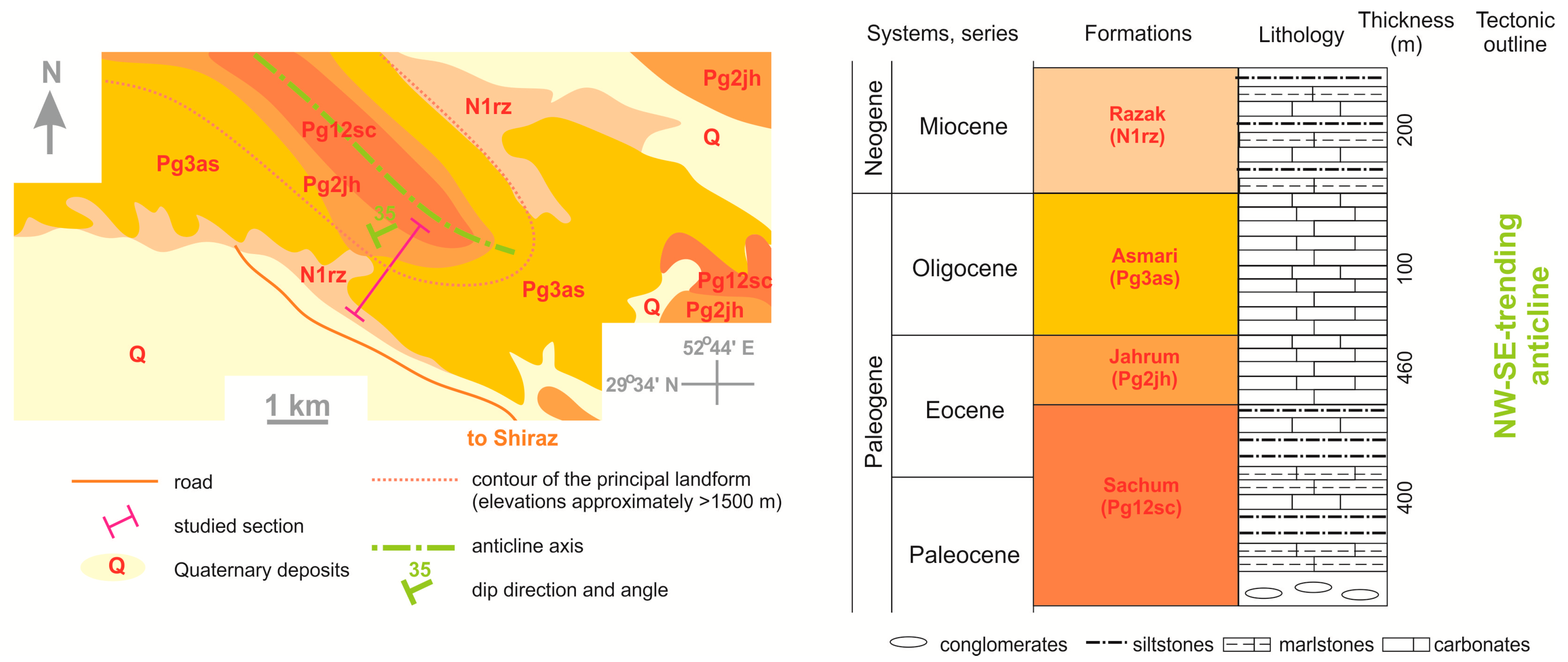
The study area is located near Shiraz City in the Fars Province of Iran. Geologically, it consists of Cenozoic deposits that form the Abmorghan anticline (Figure 2). These deposits include three Paleogene formations (Sachun, Jahrum, and Asmari) with the total thickness of ~1000 m, the Miocene Razak Formation (200 m), and Quaternary sediments. Their stratigraphical and structural frameworks were proposed by Anadlibi [52] and James and Wynd [53], and slightly improved in the course of the present study. The Paleocene–Miocene sedimentary succession is dominated by carbonates (limestones, sandy limestones, and dolomitic limestones), marlstones, siltstones, and rare conglomerates (Figure 2). According to the paleo-geographical reconstruction [49], these deposits formed on the margin of the Neo-Tethys’s branch that stretched between Arabia and the Iranian terranes in the early–middle Cenozoic. Carbonate platform environments were common in this time span. The Abmorghan anticline developed, most probably, together with the main deformation phase in the Zagros orogen, which occurred after the early Miocene [54,55].
A natural section is exposed along the southwestern limb of the Abmorghan Anticline (Figure 2). It shows all the above-mentioned formations, and, in particular, it is essential for the observation of the Jahrum Formation. The latter is dominated by limestones and dolomitic limestones with rare marlstone interbed. It is one of the most important hydrocarbon reservoirs of the Zagros [56,57,58,59,60]. This formation, with a thickness exceeding 450 m, conformably overlies the Sachun Formation, and it is disconformably overlain by the Asmari Formation. The Jahrum Formation shows a rich fauna represented by foraminifers, bivalves, gastropods, bryozoans, echinoids, and other fossils, and their investigations facilitate stratigraphical and paleo-biogeographical developments. This formation is distributed widely in the Zagros, and the Abmorghan anticline with the described section provides some important clues for its understanding.

2.2. Skala Monocline (Greater Caucasus)

The second study area is located in the Greater Caucasus orogen. This elongated geological domain crosses the vast territory between the Black Sea and the Caspian Sea (Figure 1), and its western and northern parts are located in Russia. The geological setting of this orogen was characterized by Adamia et al. [61], Forte et al. [62], Koronovskiy [63], Mosar et al. [64], and Somin [65]. It was formed in the late Cenozoic as a result of the collision between the Eurasian Plate and the smaller tectonic blocks on its southern periphery (nonetheless, the northward motion of the Arabian Plate was an important factor). The geological history of the Greater Caucasus was highly complex, with several changes in its tectonic regimes. In particular, the tectonic development of this geological domain was related to the dynamics of the terranes derived from the northern periphery of Gondwana in the Paleozoic [66] and the long-term evolution of several island arcs and back-arc basins in the Mesozoic–early Cenozoic [49,67,68,69,70,71,72]. It was also linked to the general history of the northern periphery of the Neo-Tethys Ocean. The growth of the Greater Caucasus was related to the same mechanism that determined the Zagros orogeny, but the initiation of the Cenozoic collisions was diachronous across the Middle East [73].
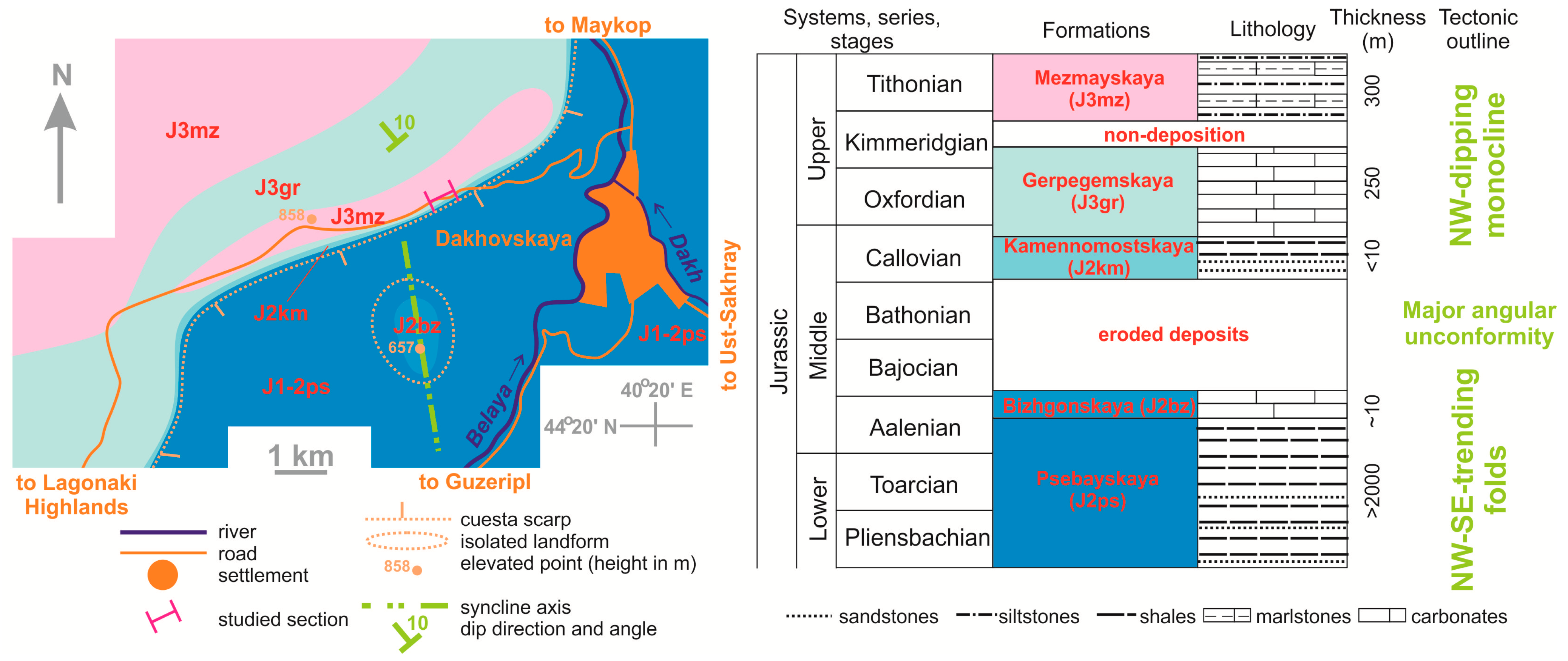
The study area is situated near Dakhovskaya Village (~50 km south of Maykop City) in the Republic of Adygeya of Russia. Geologically, it is dominated by Jurassic deposits that form different tectonic structures (Figure 3). These deposits belong to the Psebayskaya and Bizhgonskaya formations with the total thickness of >2000 m and the Kamennomostskaya, Gerpegemskaya, and Mezmayskaya formations with the total thickness of ~550 m. The regional stratigraphical framework was proposed by Rostovtsev et al. [74], and it has been updated for the purposes of the present study. The two lower formations are dominated by folded fine siliciclastic deposits (Figure 3). The three upper formations are dominated by carbonates (limestones and dolostones) overlain by variegated fine siliciclastic deposits with interbeds of limestones and marlstones. This sedimentary complex dips to the northwest with low angles (Figure 3), and, thus, it forms the Skala monocline (Skala is a notable landscape locality in the “core” of this domain). All these deposits formed in the Caucasian Palaeosea, which was a semi-enclosed, marginal sea of the Neo-Tethys Ocean [49,75,76]. This basin was characterized by deep marine conditions in the Early–Middle Jurassic. It became much shallower in the Late Jurassic when carbonate platform environments dominated [77,78]. The palaeosea experienced desiccation in the second half of the Late Jurassic when sabkha deposits of the Mezmayskaya Formation accumulated [79]. The origin of the folding of the Early–Middle Jurassic deposits is yet to be fully understood. Regarding the Skala monocline, it apparently formed together with the growth of the Greater Caucasus orogen in the late Cenozoic [62,64,80].
There is a section consisting of several outcrops (both natural and road cuttings) in the most elevated part of the Skala monocline (Figure 3). This section is found where the paved road crosses the edge of the cuesta-type range (its northern slope is gentle, and its southern slope is steep), and the outcrops are located in the cuesta scarp. It includes the Gerpegemskaya and Mezmayskaya formations. Although their contact is masked by vegetation, this section is essential to the understanding of the transition from carbonate platform to sabkha paleo-environments, as well as to the studies of the structural outline of the monocline.

3. Materials and Methods

For the purposes of the present study, a new approach can be proposed for judgments of the educational potential of geoheritage localities (the term locality is used as a more general term than geosite). It has something in common with the above-mentioned approaches [7,39], and it is proposed tentatively for the considered localities. It includes three components, namely, descriptive, framing, and semi-quantitative components.
The descriptive component of the proposed approach includes the qualitative characteristics of the geological context of the given locality and its description as a geoheritage object (uniqueness, content, geometry, dynamics, accessibility, vulnerability, and aesthetics). It should be noted that the uniqueness is a relational characteristic. Any quantitative or semi-quantitative assessment of geosites, such as those proposed by Brilha [7] or used by Gutak et al. [23] are outside the scope of the present study, which focuses on the geoeducational potential. Moreover, this study deals with localities, not geosites, because many localities hosting geoheritage and suitable for geoeducation can be, in fact, parts of larger geosites.
The framing component of the proposed approach has two elements. First, the well-shaped teaching topics are outlined. These are selected so as to efficiently communicate the geological information from the given locality and to address some principal themes taught in the university-based geoscience programs. Evidently, these topics should be considered in correspondence with the key geological disciplines (stratigraphy, sedimentology, structural geology, petrology, paleontology, etc.). For instance, some advanced technologies and tools can help to acquire the basic knowledge and skills in structural geology [81,82,83], but only field experience (also based on geoheritage objects) can enhance the students’ understanding of various structures [84,85]. Second, the given locality is checked to determine if it is suitable for three important educational procedures (opportunities), namely, learning, practicing, and challenging. Learning means listening to the professional explanations linking the major themes of the geological disciplines and the established topics. Practicing means developing and training students’ skills using the locality’s peculiarities. The importance of field practice in geological education is indisputable [85,86,87,88,89,90]. Finally, challenging means posing complex, non-trivial questions to students to facilitate their creativity and to avoid thinking by templates (the need for this in the related teaching techniques is known from the literature [91,92,93]).
The semi-quantitative component of the proposed approach is based on scoring localities by several criteria, each of which can be evaluated objectively (Table 1). Two basic criteria are the number of teaching topics (see above) and the diversity of the teaching opportunities. Indeed, a greater number of topics enlarges the educational potential of a given geosite. Similarly, geosites with only learning opportunities are less valuable than those allowing practicing and/or challenging opportunities. These criteria have higher weight than others because they determine the very existence of the educational potential. The other criteria are technical because they determine the conditions of the possible educational activities (Table 1). The criterion of remoteness should be explained. Of course, it is impossible to predict which university would be interested in organizing excursions to a given locality, and, thus, the remoteness is evaluated for only the nearest university having a geoscience program. In some (if not many) cases, this university would help other, more remote universities to organize their excursions. This should be especially common when any university has a permanent field camp (station) near the locality. The other reason is that the locality with the high geoeducational potential can be more attractive to the nearest university. The importance of the involvement of universities in geoheritage-related initiatives also matters [94,95,96]. Grades proposed for all considered criteria (Table 1) are easy to establish objectively in real examples. Nonetheless, the experience with the geoeducational activities (not necessarily with the evaluated localities) facilitates the evaluation. The total scores permit the geoeducational potential of a given geosite to be judged (Table 1). Importantly, having only basic potential does not mean a site has limited usefulness. For instance, a locality with such potential may offer teaching topics that are unavailable in other localities having larger potential.

4. Results

4.1. Abmorghan Anticline

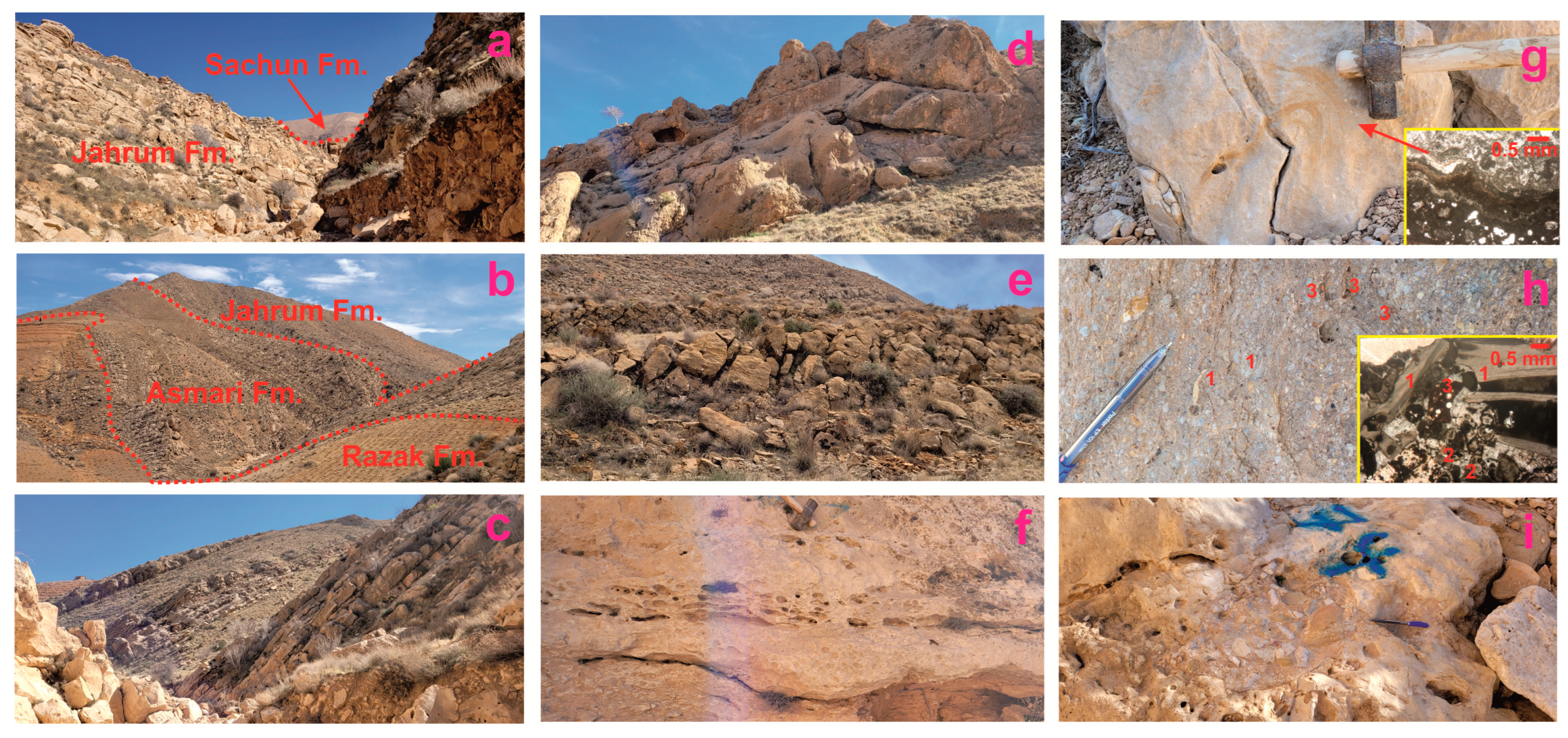
The structure consists of Paleocene–Miocene deposits extensively cropping out due to an almost absence of vegetation cover and slope debris. Small gullies offer exciting views of these deposits. All four formations (Sachun, Jahrum, Asmari, and Razak) are available for examination (Figure 2). Their stratigraphic contacts are well exposed (Figure 4a,b). In particular, a complete section of the Jahrum Formation, consisting of dolomitic limestones (Figure 4c) with rich fossil content (foraminifers, bivalves, gastropods, bryozoans, and echinoids), is visible. This locality represents the depositional environment of a carbonate platform. The peculiarities include karst features partly controlled by the dissolution of shell debris (Figure 4d–f), stromatolites (Figure 4g), and intraformational conglomerates (Figure 4h,i). The tectonic distortion of the layers proves that this is the southwestern limb of the Abmorghan anticline.
Essentially, the studied locality seems to be a geoheritage point of the large geosite corresponding to the entire Abmorghan anticline (an alternative solution would be to establish several geosites within a large serial geosite; choosing between these alternatives is left for further studies). However, such a geosite is yet to be established, and a large amount of additional field work and interpretations are required to propose it formally. The related research will achieve this goal in several years, and, thus, it would be unreasonable to propose only this locality as a separate geosite. The uniqueness of the locality is determined by its importance for studying the Paleogene formations (especially, the Jahrum Formation) and their depositional environments. Indeed, the importance is stratigraphical, paleontological, sedimentological, and paleo-geographical. This is a rather large (areal) geoheritage object representing static (not evolving) geological features. It is easily accessible by hiking, and the distance to it from the possible bus stop does not exceed several hundreds of meters. The site remains in its natural state, and, thus, it is not vulnerable to any risks. The aesthetic properties are linked to the rock layering and the visibility of geological landscapes typical of this part of the Zagros.
Three teaching topics can be outlined for the Abmorghan anticline. The first topic is “Regional Paleogene stratigraphy”, which allows the architecture of the Paleogene sedimentary complexes of this part of the Zagros to be explained and the main formations to be shown. Special attention can be paid to biostratigraphy and, particularly, the importance of microfauna (first of all, foraminifers) for age establishment and biozonation development. The second topic is “Carbonate platform evolution”, which enables the idea of tropical carbonate platforms to be explained, and the related sedimentological, paleoenvironmental, and paleo-ecological interpretations to be offered, demonstrating examples from the exposed rocks. The third topic is “Karst”, which facilitates understanding of this complex phenomenon with some examples from the considered locality. Additionally, the latter is potentially suitable for development of skills in structural geology, although the related topic can be proposed only after the future examination of the entire Abmorghan anticline as a single geosite. The studied section can be judged as the textbook locality because it contributes to the comprehension of the important topics from the university courses in stratigraphy (also historical geology), sedimentology, and paleontology. All three teaching opportunities are available there. Students can acquire various types of knowledge (see above) from their professors and develop their skills of describing and interpreting carbonate successions and (micro)fossil collecting. Giving stratigraphy-related tasks to students seems to be very promising. Students can also be challenged in regard to the possible age and formation mechanism of karst features (these are yet to be known, but it is worth thinking about them together with students) and the origin of conglomerates on the Paleogene carbonate platform.
The semi-quantitative assessment of the locality reveals its advanced educational potential (Table 2). The locality is situated ~5 km far from the large city of Shiraz, where the Shiraz University, with its strong geoscience program, is situated. This proximity permits one-day excursions for students to be organized. Although public transport is not available, there is enough space for large excursion buses very close to the locality. The latter is large enough for several dozen visitors, although the effective communication of the geological knowledge requires the size of student groups to be limited to 30–35 persons. The weather conditions are generally favorable, but not during very hot summers (any educational activities during June–July are not recommended). Additional features of interest are not available on-site, but the locality is found in one of the most important cultural and historical areas of the entire Middle East centered in Shiraz, with its outstanding heritage (the relation between the local cultural and historical heritage and geoheritage was explained by Habibi et al. [21]). The established educational potential of the considered locality is already being exploited for the purposes of teaching at Shiraz University, and some other Iranian universities can join these activities.

4.2. Skala Monocline

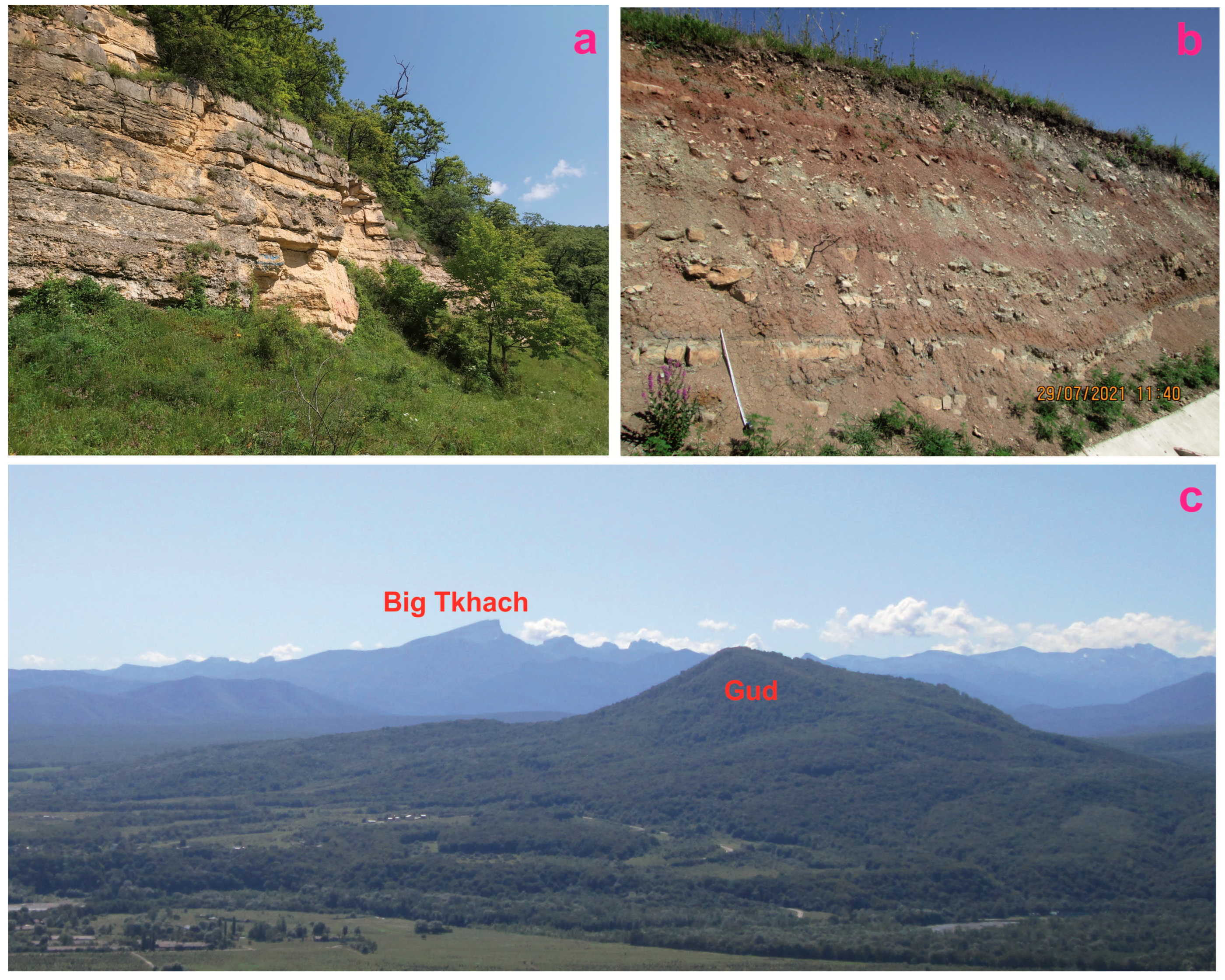
This locality includes a series of outcrops showing limestones of the Gerpegemskaya Formation deposited in a large carbonate platform environment (Figure 5a) and variegated siltstones and carbonate interbeds of the Mezmayskaya Formation accumulated in a sabkha environment (Figure 5b). The former dips to the northwest with an angle of 10°. In the other parts of the study area, the dip direction changes locally to northern, and the angle increases to 20°. The layering seems to be parallel, although inclined (Figure 5a). Structurally, this is an almost ideal monocline. In the study area, the representative outcrops of the Mezmayskaya Formation appeared only a few years ago due to road maintenance and the related slope cutting. In the other localities of the monocline, it is found that variegated siliciclastics dip with the same direction and angle as the underlying Gerpegemskaya Formation. However, two differences are visible in the considered locality. First, the Mezmayskaya Formation demonstrates minor folding (Figure 5b). Second, these deposits tend to dip in the northeastern direction with an angle of <15°. Apparently, both formations experienced minor folding, but it is only visible in the softer and rather plastic rocks of the Mezmayskaya Formation, whereas the harder limestones of the Gerpegemskaya Formation were not folded, but faulted and even “crushed”. Moreover, the above-mentioned differences in the dip direction and angle can be explained by the same folding. Taking into account these factors, it appears that the Skala monocline is not an ideal monocline. Regarding the differences between the dips of the two formations, they can be explained by some tectonic activity in the study area that continued through the Kimmeridgian when the carbonate deposition changed to a siliciclastic deposition (Figure 3). It is known that the boundary of these formations is regionally disconformous, and the lower part of the Mezmayskaya Formation can be missed locally [74]. If so, the angular unconformity between the Gerpegemskaya and Mezmayskaya formations is expected, and its explanation does not need the involvement of any specific factor such as the hypothetic mid-Kimmeridgian deformation phase; the gradual tectonic processes in the generally active domain were enough to produce this unconformity.
This locality is essentially a geoheritage point of the very large geosite, namely the Lagonaki Highland. This geosite is ranked globally, and it embraces a large area with dozens of particular geological and geomorphological localities, as well as whole geological landscapes in the “core” of the Western Caucasus [97]. The locality representing the Skala monocline seems to be the best section, bearing spectacular outcrops of the Gerpegemskaya and Mezmayskaya formations together and representing the related depositional environments; moreover, this is the key site for studying the minor folding (see above). Thus, the content is chiefly stratigraphical, paleo-geographical, and tectonic. This is the linear geoheritage object, which stretches for several hundreds of meters along the paved road connecting the tourist destination of the Lagonaki Highland and Dakhovskaya Village. This road provides exceptional accessibility to this locality. Although the latter represents static (not process-related) geological features, slope debris and vegetation can re-cover exposures of the Mezmayskaya Formation within several years, and this is a serious natural risk to this piece of geoheritage. The aesthetic properties are linked to the rock color and the structures (Figure 5a,b), as well as to the panoramic views from the edge of the cuesta range (Figure 5c).
Two teaching topics can be outlined for the Skala monocline. The first is “Depositional environments in past tropical conditions”, which includes the explanations of carbonate platforms and sabkha facies and the demonstration of the related deposits. The second, and probably most important, topic is “Monocline structures”, which allows the idea of monoclines and their expression in cuesta landforms to be explained and the differences between ideal and real monoclines to be demonstrated, taking into account the above-mentioned peculiarities of the considered section. The latter can be judged as the textbook locality because it facilitates the comprehension of the important topics from the university courses in sedimentology and structural geology. All three educational opportunities are available in the considered area. Students can learn the basic knowledge from their professors, as well as train their skills in identification of sedimentary rocks, facies interpretation, and measurements of dip directions and angles. Moreover, students can be challenged by asking to explain the minor folds and the differences in the dips of the Gerpegemskaya and Mezmayskaya formations. A more advanced theme for discussion is whether ideal monoclines exist and whether angular unconformities are possible within the deposits forming monoclines.
The semi-quantitative assessment of the locality reveals its moderate educational potential (Table 2). As explained above, there are two teaching topics and three teaching opportunities. The Southern Federal University, which organizes summer field practices for students in geology and geography, has a permanent field camp south of Dakhovskaya Village (~20 km from the locality), and, thus, visiting the Skala monocline from there by bus takes only several hours. The other universities can accommodate their students at this camp, and some of them use this opportunity on regular basis. Excursion buses are necessary, and there is enough space for them to stay near the locality. Public transport is not available, and the nearest public bus stop is located in Dakhovskaya, i.e., >5 km far from the locality. Taking into account the configuration of the section and the size of its particular outcrops, the groups of visitors should be limited to 20–25 persons (preferably, 10–15 persons) for effective educational activities. The dependence on weather conditions is strong. Too-frequent rains and snow cover complicate accessibility of the Skala monocline during November–April, and heavy rains are also frequent in the other half of the year. Note that the educational activities require the outcrops to be dry. The other feature of interest is the 180° panoramic view from the other side of the road (relative to the section). In addition to the high aesthetic properties of the landscape, one can see the Gud Mountain, which is a classical inverted landform [98], and the Big Tkhach Mountain, which is a Late Triassic reef [99,100] (Figure 5c). The established educational potential of the considered locality can be easily exploited by several Russian universities (e.g., Southern Federal University, Voronezh State University, and Saratov State University) organizing field practice for their students in the Republic of Adygeya.

5. Discussion and Conclusions

The idea of textbook localities and their availability evidenced by the examples from Iran and Russia raises two questions about the exploitation of the established educational potential of geoheritage. The first is about the sufficiency of this potential. A single locality with moderate or even advanced potential may not be sufficient to include it in geoeducational programs. Apparently, the majority of localities (geosites) can provide one–two (rarely three or more) teaching topics. Is it rational to organize excursions for students to such a place? In fact, this seems to be a complex question without any definite answer. On one hand, if a university is located close to a single locality with more-or-less high educational potential, and organizing an excursion to that locality does not require extraordinary efforts, it appears to be reasonable to exploit the locality for educational purposes (in other words, it is better to do something than nothing, especially because students in geosciences always need field experience). On the other hand, the groups of textbook localities in the same area would be preferred for field-based geoscience teaching, and, thus, it would be reasonable to also consider the territorial geoeducational potential. It is well-known that geoparks comprising several geosites provide excellent opportunities for geoeducation [10,101,102]. Regarding the localities considered in the present study, it is known that both are located in geoheritage-rich areas [21,97] where some other textbook localities can be found.
The second question is about the promotion and the interpretation of the localities with the proven geoeducational potential, i.e., about their marketing. How can organizers of field practice and excursions for students learn about the availability of the textbook localities and interpret them correctly? The problem does not exist if these organizers (presumably, these are faculty members of universities) are involved in the local geoheritage-related research. However, this is not a very common situation. Marketing approaches in geotourism [103,104,105,106,107] may not be efficient because they are developed for a different target audience. Three solutions can be proposed. First, it is reasonable to report new geosites and geoheritage areas in international, national, and local academic journals, as well as to publish the outcomes of their comprehensive or specialized geoheritage assessments. Importantly, attention should also be paid to the technical properties of geosites, which are essential to realize whether they can be used for the purposes of geoeducation “here and now”. Second, there is a need for special, university-based/-sponsored projects aimed at the identification of localities with geoeducational potential for the purpose of the optimal design of field teaching. Third, it appears essential to create and then to install interpretive panels and to distribute brochures characterizing the localities with geoeducational potential and focusing on the pre-established teaching topics and procedures. Although the general principles of their creation [108,109,110] can be followed, the specific needs of student teaching should be addressed. Moreover, the entire excursion routes need adequate development and maintenance [111]. Online materials are also promising, but it should be taken into account that a connection to the Internet may not be available in the field, and, thus, efforts should be concentrated on traditional, paper-based materials.
In conclusions, the present study establishes, for the first time, the educational potential of two, essentially different geological textbook localities of Zagros and the Greater Caucasus. First, it is found that these localities allow teaching several topics related to the fundamental geological disciplines. Second, these localities enable students to learn, practice, and be challenged, which are essential to their education. Third, the proposed approach enables the differentiation of the localities depending on their educational potential, and this novel development extends the vision of the geoheritage potential for communicating basic geological knowledge. Fourth, it is argued that the exploitation of such potential is facilitated by the availability of several localities (geosites) suitable for geoeducation. Fifth, the marketing of the textbook localities requires special procedures and efforts, which can be linked to the university-based initiatives. The main limitation of the present study is its sole focus on geological education at universities, which is the important form of geoeducation in Iran and Russia. Nonetheless, geoeducation can also be offered to schoolchildren, geology amateurs, and even the lay public, sharing many features with geotourism. The related refinement of the proposed approach is a task for further studies. An important research perspective is also the development of the scientific foundation for the national frameworks of geoheritage-based geoscience education.

Author Contributions

Conceptualization, T.H., D.A.R. and V.A.E.; investigation, T.H. and D.A.R.; writing—original draft preparation, T.H., D.A.R. and V.A.E. All authors have read and agreed to the published version of the manuscript.

Funding

This research received no external funding.

Data Availability Statement

Not applicable.

Acknowledgments

We thank gratefully the reviewers for their valuable recommendations, as well as the Shiraz University research council for providing field trip logistics.

Conflicts of Interest

The authors declare no conflict of interest.

References

  1. Bentivenga, M.; Cavalcante, F.; Mastronuzzi, G.; Palladino, G.; Prosser, G. Geoheritage: The Foundation for Sustainable Geotourism. Geoheritage 2019, 11, 1367–1369. [Google Scholar] [CrossRef]
  2. Pescatore, E.; Bentivenga, M.; Giano, S.I.; Siervo, V. Geomorphosites: Versatile Tools in Geoheritage Cultural Dissemination. Geoheritage 2019, 11, 1583–1601. [Google Scholar] [CrossRef]
  3. Pescatore, E.; Bentivenga, M.; Giano, S.I. Geoheritage and Geoconservation: Some Remarks and Considerations. Sustainability 2023, 15, 5823. [Google Scholar] [CrossRef]
  4. Prosser, C.D.; Brown, E.J.; Larwood, J.G.; Bridgland, D.R. Geoconservation for science and society—An agenda for the future. Proc. Geol. Assoc. 2013, 124, 561–567. [Google Scholar] [CrossRef]
  5. Valentini, L.; Guerra, V.; Lazzari, M. Enhancement of geoheritage and development of geotourism: Comparison and inferences from different experiences of communication through art. Geosciences 2022, 12, 264. [Google Scholar] [CrossRef]
  6. Bollati, I.M.; Rossi, D.; Viani, C. Outdoor River Activities: Relations with Geological Background and Extreme Events in the Perspective of Geoeducation. Geosciences 2023, 13, 122. [Google Scholar] [CrossRef]
  7. Brilha, J. Inventory and Quantitative Assessment of Geosites and Geodiversity Sites: A Review. Geoheritage 2016, 8, 119–134. [Google Scholar] [CrossRef]
  8. Cho, H.; Kim, J.-S.; Kang, H.-C.; Park, J.-W.; Shin, S.; Chae, Y.-U.; Ha, S.; Kim, H.S.; Lim, H.S. Geological values of the Ueumdo geosite in the Hwaseong Geopark, Korea and its application to geo-education. J. Geol. Soc. Korea 2021, 57, 257–273. [Google Scholar] [CrossRef]
  9. Pardo-Igúzquiza, E.; Durán-Valsero, J.J.; Dowd, P.A.; Luque-Espinar, J.A.; Heredia, J.; Robledo-Ardila, P.A. Geodiversity of closed depressions in a high relief karst: Geoeducation asset and geotourism resource in the “Sierra de las Nieves” National Park (Málaga Province, Southern Spain). Int. J. Geoheritage Parks 2022, 10, 196–217. [Google Scholar] [CrossRef]
  10. Schmid-Röhl, A.P. The Lower Jurassic Posidonia Shale in the Swabian Alb Geopark—Geoeducation in an Industrial Environment. Geoconservation Res. 2021, 4, 338–346. [Google Scholar]
  11. Tormey, D. New approaches to communication and education through geoheritage. Int. J. Geoheritage Parks 2019, 7, 192–198. [Google Scholar] [CrossRef]
  12. Zafeiropoulos, G.; Drinia, H. Comparative Analysis of Two Assessment Methods for the Geoeducational Values of Geosites. A Case Study from the Volcanic Island of Nisyros, SE Aegean Sea, Greece. Geosciences 2022, 12, 82. [Google Scholar] [CrossRef]
  13. Kubalíková, L.; Bajer, A.; Balková, M.; Kirchner, K.; Machar, I. Geodiversity Action Plans as a Tool for Developing Sustainable Tourism and Environmental Education. Sustainability 2022, 14, 6043. [Google Scholar] [CrossRef]
  14. Pasquaré Mariotto, F.; Venturini, C. Strategies and Tools for Improving Earth Science Education and Popularization in Museums. Geoheritage 2017, 9, 187–194. [Google Scholar] [CrossRef]
  15. Telbisz, T.; Imecs, Z.; Máthé, A.; Mari, L. Empirical Investigation of the Motivation and Perception of Tourists Visiting the Apuseni Nature Park (Romania) and the Relationship of Tourism and Natural Resources. Sustainability 2023, 15, 4181. [Google Scholar] [CrossRef]
  16. Vegas, J.; Díez-Herrero, A. An Assessment Method for Urban Geoheritage as a Model for Environmental Awareness and Geotourism (Segovia, Spain). Geoheritage 2021, 13, 27. [Google Scholar] [CrossRef]
  17. Vidal, R.R.; Tassara, A. Geo-Circuit for Interpretation of the Geological Evolution in the Nevados de Chillán Volcanic Complex, Chile. Geoheritage 2023, 15, 63. [Google Scholar] [CrossRef]
  18. Derafshi, K.; Seyedhamzeh, M. Synthesis of Quantitative Geosite Assessment Models and Its Application on Sistan and Baluchestan Province Natural Heritages, Potential Geotourism Destination of Iran. Geoheritage 2022, 14, 124. [Google Scholar] [CrossRef]
  19. Farsani, N.T.; Coelho, C.; Costa, C. Geotourism and Geoparks as Gateways to Socio-cultural Sustainability in Qeshm Rural Areas, Iran. Asia Pac. J. Tour. Res. 2012, 17, 30–48. [Google Scholar] [CrossRef]
  20. Ghasemi, M.; Ghanavati, E.; Kazemi, J. Identifying the Most Effective Geosite Evaluation Models in Iran Using Delphi and Analytic Hierarchy Process Methods. Quaest. Geogr. 2021, 40, 21–31. [Google Scholar] [CrossRef]
  21. Habibi, T.; Ponedelnik, A.A.; Yashalova, N.N.; Ruban, D.A. Urban geoheritage complexity: Evidence of a unique natural resource from Shiraz city in Iran. Resour. Policy 2018, 59, 85–94. [Google Scholar] [CrossRef]
  22. Mehdipour Ghazi, J.; Hamdollahi, M.; Moazzen, M. Geotourism of mining sites in Iran: An opportunity for sustainable rural development. Int. J. Geoheritage Parks 2021, 9, 129–142. [Google Scholar] [CrossRef]
  23. Gutak, J.M.; Ruban, D.A.; Ermolaev, V.A. Devonian geoheritage of Siberia: A case of the northwestern Kemerovo Region of Russia. Heliyon 2023, 9, e13288. [Google Scholar] [CrossRef] [PubMed]
  24. Karpunin, A.M.; Mamonov, S.V.; Mironenko, O.A.; Sokolov, A.R. Geological Monuments of Nature of Russia; Lorien: Sankt-Peterburg, Russia, 1998. (In Russian) [Google Scholar]
  25. Marshall, J.E.A.; Siveter, D.J. The Lake Il’men Clint, Russia: A potential Devonian geopark. J. Min. Inst. 2018, 234, 581–590. [Google Scholar] [CrossRef]
  26. Herrera-Franco, G.; Carrión-Mero, P.; Montalván-Burbano, N.; Caicedo-Potosí, J.; Berrezueta, E. Geoheritage and Geosites: A Bibliometric Analysis and Literature Review. Geosciences 2022, 12, 169. [Google Scholar] [CrossRef]
  27. Ólafsdóttir, R.; Tverijonaite, E. Geotourism: A systematic literature review. Geosciences 2018, 8, 234. [Google Scholar] [CrossRef]
  28. Ziaee, M.; Ferdowsi, S. A Systematic Review of Iranian Research in the Field of Geotourism Studies. Geoheritage 2020, 12, 94. [Google Scholar] [CrossRef]
  29. Drápela, E. Assessing the Educational Potential of Geosites: Introducing a Method Using Inquiry-Based Learning. Resources 2022, 11, 101. [Google Scholar] [CrossRef]
  30. García-Ortiz, E.; Fuertes-Gutiérrez, I.; Fernández-Martínez, E. Concepts and terminology for the risk of degradation of geological heritage sites: Fragility and natural vulnerability, a case study. Proc. Geol. Assoc. 2014, 125, 463–479. [Google Scholar] [CrossRef]
  31. Guerra, V.; Lazzari, M. Geomorphological mapping as a tool for geoheritage inventory and geotourism promotion: A case study from the middle valley of the Marecchia River (northern Italy). Géomorphologie Relief Process. Environ. 2021, 27, 127–145. [Google Scholar] [CrossRef]
  32. Guerra, V.; Lazzari, M. Geoheritage assessment and potential geotouristic enhancement in mountain environments: A test-site in the northern Apennines (Italy). Geoheritage 2022, 14, 97. [Google Scholar] [CrossRef]
  33. Kubalíková, L.; Kirchner, K. Geosite and Geomorphosite Assessment as a Tool for Geoconservation and Geotourism Purposes: A Case Study from Vizovická vrchovina Highland (Eastern Part of the Czech Republic). Geoheritage 2016, 8, 5–14. [Google Scholar] [CrossRef]
  34. Morante-Carballo, F.; Merchán-Sanmartín, B.; Cárdenas-Cruz, A.; Jaya-Montalvo, M.; Mata-Perello, J.; Herrera-Franco, G.; Carrión-Mero, P. Sites of Geological Interest Assessment for Geoeducation Strategies, ESPOL University Campus, Guayaquil, Ecuador. Land 2022, 11, 771. [Google Scholar] [CrossRef]
  35. Pasquaré Mariotto, F.; Drymoni, K.; Bonali, F.L.; Tibaldi, A.; Corti, N.; Oppizzi, P. Geosite Assessment and Communication: A Review. Resources 2023, 12, 29. [Google Scholar] [CrossRef]
  36. Štrba, L.; Rybár, P.; Baláž, B.; Molokac, M.; Hvizdak, L.; Krsak, B.; Lukac, M.; Muchova, L.; Tometzová, D.; Ferenčíková, J. Geosite assessments: Comparison of methods and results. Curr. Issues Tour. 2015, 18, 496–510. [Google Scholar] [CrossRef]
  37. Štrba, Ľ.; Vravcová, A.; Podoláková, M.; Varcholová, L.; Kršák, B. Linking Geoheritage or Geosite Assessment Results with Geotourism Potential and Development: A Literature Review. Sustainability 2023, 15, 9539. [Google Scholar] [CrossRef]
  38. Tomić, N.; Božić, S. A modified geosite assessment model (M-GAM) and its application on the Lazar Canyon area (Serbia). Int. J. Environ. Res. 2014, 8, 1041–1052. [Google Scholar]
  39. Vujičić, M.D.; Vasiljević, Đ.A.; Marković, S.B.; Hose, T.A.; Lukić, T.; Hadžić, O.; Janićević, S. Preliminary geosite assessment model (GAM) and its application on Fruška Gora Mountain, potential geotourism destination of Serbia. Acta Geogr. Slov. 2011, 51, 361–377. [Google Scholar] [CrossRef]
  40. Kirillova, K. A review of aesthetics research in tourism: Launching the Annals of Tourism Research Curated Collection on beauty and aesthetics in tourism. Ann. Tour. Res. 2023, 100, 103553. [Google Scholar] [CrossRef]
  41. Alavi, M. Tectonics of the Zagros orogenic belt of Iran: New data and interpretations. Tectonophysics 1994, 229, 211–238. [Google Scholar] [CrossRef]
  42. Alipour, M. Collision along irregular plate margin controlled the tectono-stratigraphic evolution of the Iranian Zagros fold and thrust belt. Mar. Pet. Geol. 2023, 154, 106311. [Google Scholar] [CrossRef]
  43. Mouthereau, F.; Lacombe, O.; Vergés, J. Building the Zagros collisional orogen: Timing, strain distribution and the dynamics of Arabia/Eurasia plate convergence. Tectonophysics 2012, 532–535, 27–60. [Google Scholar] [CrossRef]
  44. Ruh, J.B.; Gerya, T.; Burg, J.-P. Toward 4D modeling of orogenic belts: Example from the transpressive Zagros Fold Belt. Tectonophysics 2017, 702, 82–89. [Google Scholar] [CrossRef]
  45. Sepehr, M.; Cosgrove, J.W. Structural framework of the Zagros Fold-Thrust Belt, Iran. Mar. Pet. Geol. 2004, 21, 829–843. [Google Scholar] [CrossRef]
  46. Zamani, B.G. Geodynamics and tectonic stress model for the Zagros fold–thrust belt and classification of tectonic stress regimes. Mar. Pet. Geol. 2023, 155, 106340. [Google Scholar]
  47. Ajirlu, M.S.; Moazzen, M.; Hajialioghli, R. Tectonic evolution of the Zagros Orogen in the realm of the Neotethys between the Central Iran and Arabian Plates: An ophiolite perspective. Cent. Eur. Geol. 2016, 59, 1–27. [Google Scholar] [CrossRef]
  48. Arfania, R.; Shahriari, S. Role of southeastern Sanandaj-Sirjan Zone in the tectonic evolution of Zagros Orogenic Belt, Iran. Isl. Arc 2009, 18, 555–576. [Google Scholar] [CrossRef]
  49. Golonka, J. Plate tectonic evolution of the southern margin of Eurasia in the Mesozoic and Cenozoic. Tectonophysics 2004, 381, 235–273. [Google Scholar] [CrossRef]
  50. Jafari, A.; Ao, S.; Jamei, S.; Ghasemi, H. Evolution of the Zagros sector of Neo-Tethys: Tectonic and magmatic events that shaped its rifting, seafloor spreading and subduction history. Earth-Sci. Rev. 2023, 241, 104419. [Google Scholar] [CrossRef]
  51. Leturmy, P.; Robin, C. Tectonic and stratigraphic evolution of Zagros and Makran during the Mesozoic-Cenozoic: Introduction. Geol. Soc. Spec. Publ. 2010, 330, 1–4. [Google Scholar] [CrossRef]
  52. Andadlibi, M.J. Geological Map of Iran, Scale 1:1000000; Geological Survey of Iran: Tehran, Iran, 1967. [Google Scholar]
  53. James, G.A.; Wynd, J.G. Stratigraphic nomenclature of Iranian Oil Consortium Agreement Area. AAPG Bull. 1965, 49, 2182–2245. [Google Scholar]
  54. Ghanbarian, M.A.; Derakhshani, R. The folds and faults kinematic association in Zagros. Sci. Rep. 2022, 12, 8350. [Google Scholar] [CrossRef] [PubMed]
  55. Soleimany, B.; Sàbat, F. Style and age of deformation in the NW Persian Gulf. Pet. Geosci. 2010, 16, 31–39. [Google Scholar] [CrossRef]
  56. Babazadeh, S.A.; Cluzel, D. New biostratigraphy and microfacies analysis of Eocene Jahrum Formation (Shahrekord region, High Zagros, West Iran). A carbonate platform within the Neo-Tethys oceanic realm. BSGF—Earth Sci. Bull. 2023, 194, 1. [Google Scholar] [CrossRef]
  57. Fallah-Bagtash, R.; Adabi, M.H.; Sadeghi, A.; Dehyadegari, E. Reservoir quality of the Jahrum carbonate succession; a case study from the Fars region of Zagros Basin, SW Iran. J. Stratigr. Sedimentol. Res. 2020, 36, 27–58. [Google Scholar]
  58. Mohseni, H.; Hassanvand, V.; Homaie, M. Microfacies analysis, depositional environment, and diagenesis of the Asmari–Jahrum reservoir in Gulkhari oil field, Zagros basin, SW Iran. Arab. J. Geosci. 2016, 9, 113. [Google Scholar] [CrossRef]
  59. Parvaneh Nejad Shirazi, M.; Bahrami, M.; Amiri Bakhtiar, H.; Bamdad, O. Microfacies, sedimentary environment and paleoecology of Paleocene-Eocene deposits in the Zagros Basin, north of Shiraz, southwest Iran. Hist. Biol. 2014, 26, 493–501. [Google Scholar] [CrossRef]
  60. Sinapour, M.; Seyrafian, A. Microfacies and sedimentary environment of the Jahrum formation, south-central Zagros basin. Carbonates Evaporites 2021, 36, 76. [Google Scholar] [CrossRef]
  61. Adamia, S.; Zakariadze, G.; Chkhotua, T.; Sadradze, N.; Tsereteli, N.; Chabukiani, A.; Gventsadze, A. Geology of the Caucasus: A review. Turk. J. Earth Sci. 2011, 20, 489–544. [Google Scholar] [CrossRef]
  62. Forte, A.M.; Gutterman, K.R.; van Soest, M.C.; Gallagher, K. Building a Young Mountain Range: Insight Into the Growth of the Greater Caucasus Mountains From Detrital Zircon (U-Th)/He Thermochronology and 10Be Erosion Rates. Tectonics 2022, 41, e2021TC006900. [Google Scholar] [CrossRef]
  63. Koronovskiy, N.V. The Caucasus: Unsolved problems of geology. Vestn.—Mosk. Univ. Seriya Geol. 1990, 4, 3–11. [Google Scholar]
  64. Mosar, J.; Mauvilly, J.; Koiava, K.; Gamkrelidze, I.; Enna, N.; Lavrishev, V.; Kalberguenova, V. Tectonics in the Greater Caucasus (Georgia—Russia): From an intracontinental rifted basin to a doubly verging fold-and-thrust belt. Mar. Pet. Geol. 2022, 140, 105630. [Google Scholar] [CrossRef]
  65. Somin, M.L. Pre-Jurassic basement of the Greater Caucasus: Brief overview. Turk. J. Earth Sci. 2011, 20, 545–610. [Google Scholar] [CrossRef]
  66. Ruban, D.A.; Zerfass, H.; Yang, W. A new hypothesis on the position of the Greater Caucasus Terrane in the Late Palaeozoic-Early Mesozoic based on palaeontologic and lithologic data. Trab. De Geol. 2007, 27, 19–27. [Google Scholar]
  67. Adamia, S.; Alania, V.; Chabukiani, A.; Kutelia, Z.; Sadradze, N. Great Caucasus (Cavcasioni): A long-lived North-Tethyan back-arc basin. Turk. J. Earth Sci. 2011, 20, 611–628. [Google Scholar] [CrossRef]
  68. Hässig, M.; Moritz, R.; Ulianov, A.; Popkhadze, N.; Galoyan, G.; Enukidze, O. Jurassic to Cenozoic Magmatic and Geodynamic Evolution of the Eastern Pontides and Caucasus Belts, and Their Relationship With the Eastern Black Sea Basin Opening. Tectonics 2020, 39, e2020TC006336. [Google Scholar] [CrossRef]
  69. Kazmin, V.G.; Tikhonova, N.F. Evolution of Early Mesozoic back-arc basins in the Black Sea—Caucasus segment of a Tethyan active margin. Geol. Soc. Spec. Publ. 2006, 260, 179–200. [Google Scholar] [CrossRef]
  70. McCann, T.; Chalot-Prat, F.; Saintot, A. The Early Mesozoic evolution of the Western Greater Caucasus (Russia): Triassic-Jurassic sedimentary and magmatic history. Geol. Soc. Spec. Publ. 2010, 340, 181–238. [Google Scholar] [CrossRef]
  71. Okay, A.I.; Nikishin, A.M. Tectonic evolution of the southern margin of Laurasia in the Black Sea region. Int. Geol. Rev. 2015, 57, 1051–1076. [Google Scholar] [CrossRef]
  72. Trifonov, V.G.; Sokolov, S.Y.; Sokolov, S.A.; Hessami, K. Mesozoic–Cenozoic Structure of the Black Sea–Caucasus–Caspian Region and Its Relationships with the Upper Mantle Structure. Geotectonics 2020, 54, 331–355. [Google Scholar] [CrossRef]
  73. Darin, M.H.; Umhoefer, P.J. Diachronous initiation of Arabia–Eurasia collision from eastern Anatolia to the southeastern Zagros Mountains since middle Eocene time. Int. Geol. Rev. 2022, 64, 2653–2681. [Google Scholar] [CrossRef]
  74. Rostovtsev, K.O.; Agaev, V.B.; Azarian, N.R.; Babaev, R.G.; Besnosov, N.V.; Hassanov, N.A.; Zesashvili, V.I.; Lomize, M.G.; Paitschadze, T.A.; Panov, D.I.; et al. Jurassic of the Caucasus; Nauka: St. Petersburg, Russia, 1992. (In Russian) [Google Scholar]
  75. Yasamanov, N.A. Landscape-Climatic Conditions of the Jurassic, the Cretaceous and the Paleogene of the South of the USSR; Nedra: Moscow, Russia, 1978. (In Russian) [Google Scholar]
  76. Ruban, D.A. The palaeogeographic outlines of the Caucasus in the Jurassic: The Caucasian Sea and the Neotethys Ocean. Geol. Anal. Balk. Poluostrva 2006, 67, 1–11. [Google Scholar] [CrossRef]
  77. Guo, L.; Vincent, S.J.; Lavrishchev, V. Upper Jurassic reefs from the Russian Western Caucasus: Implications for the eastern Black Sea. Turk. J. Earth Sci. 2011, 20, 629–653. [Google Scholar] [CrossRef]
  78. Kuznetsov, V.G. Late Jurassic—Early Cretaceous carbonate platform in the northern Caucasus and Precaucasus. Am. Assoc. Pet. Geol. Mem. 1993, 56, 455–463. [Google Scholar]
  79. Ruban, D.A.; Mikhailenko, A.V.; Zorina, S.O.; Yashalova, N.N. Geoheritage Resource of a Small Town: Evidence from Southwestern Russia. Geoheritage 2021, 13, 82. [Google Scholar] [CrossRef]
  80. Avdeev, B.; Niemi, N.A. Rapid Pliocene exhumation of the central Greater Caucasus constrained by low-temperature thermochronometry. Tectonics 2011, 30, TC2009. [Google Scholar] [CrossRef]
  81. Delgado, J.; López, J.; Zárate, I.; Montes, C. Modeling subduction on the kitchen table. J. Struct. Geol. 2023, 166, 104772. [Google Scholar] [CrossRef]
  82. Gutierrez, J.; Akciz, S.O.; Bursztyn, N.; Nichols, K.; Thurmond, J. Testing the efficacy of 3D-printed geologic models as tools for fostering spatial visualization abilities. Int. Geol. Rev. 2023, 65, 1320–1330. [Google Scholar] [CrossRef]
  83. Horota, R.K.; Senger, K.; Rodes, N.; Betlem, P.; Smyrak-Sikora, A.; Jonassen, M.O.; Kramer, D.; Braathen, A. West Spitsbergen fold and thrust belt: A digital educational data package for teaching structural geology. J. Struct. Geol. 2023, 167, 104781. [Google Scholar] [CrossRef]
  84. Joshi, A.U.; Gorania, P.; Limaye, M.A.; Chauhan, G.D.; Thakkar, M.G. Geoheritage Values of the Champaner-Pavagadh Archaeological Park, UNESCO World Heritage Site, Gujarat, Western India. Geoheritage 2022, 14, 88. [Google Scholar] [CrossRef]
  85. Puckette, J.O.; Suneson, N.H. Field camp: Using traditional methods to train the next generation of petroleum geologists. Spec. Pap. Geol. Soc. Am. 2009, 461, 25–34. [Google Scholar]
  86. Anderson, D.S.; Miskimins, J.L. Using field-camp experiences to develop a multidisciplinary foundation for petroleum engineering students. J. Geosci. Educ. 2006, 54, 172–178. [Google Scholar] [CrossRef]
  87. Balliet, R.N.; Riggs, E.M.; Maltese, A.V. Students’ problem solving approaches for developing geologic models in the field. J. Res. Sci. Teach. 2015, 52, 1109–1131. [Google Scholar] [CrossRef]
  88. Jolley, A.; Kennedy, B.M.; Brogt, E.; Hampton, S.J.; Fraser, L. Are we there yet? Sense of place and the student experience on roadside and situated geology field trips. Geosphere 2018, 14, 651–667. [Google Scholar] [CrossRef]
  89. Kelley, D.F.; Sumrall, J.L.; Sumrall, J.B. Student-designed mapping project as part of a geology field camp. J. Geosci. Educ. 2015, 63, 198–209. [Google Scholar] [CrossRef]
  90. Kelley, D.F.; Uzunlar, N.; Lisenbee, A.; Beate, B.; Turner, H.E. A capstone course in ecuador: The andes/galápagos volcanology field camp program. J. Geosci. Educ. 2017, 65, 250–262. [Google Scholar] [CrossRef]
  91. Ettensohn, F.R. An experiment in collaborative mapping at geology field camp. J. Geosci. Educ. 1997, 45, 229–234. [Google Scholar] [CrossRef]
  92. Rodríguez-Oroz, D.; Gómez-Espina, R.; Pérez, M.J.B.; Truyol, M.E. Learning based on a gamification project: Connecting university education and Chilean geomorphology dissemination. Rev. Eureka 2019, 16, 2202. [Google Scholar]
  93. Shang, M.; Yi, W.; Xu, Q. The study of engineering geology teaching based on the creativity thinking training. Adv. Mater. Res. 2013, 655–657, 2194–2197. [Google Scholar] [CrossRef]
  94. Kanayama, K.; Ota, Y. Sharing scientific knowledge in the process of creating textbook for guide in Uradome Coast, Tottori Prefecture, Japan. Chikei/Trans. Jpn. Geomorphol. Union 2022, 43, 41–54. [Google Scholar]
  95. Singtuen, V.; Vivitkul, N.; Junjuer, T. Geoeducational assessments in Khon Kaen National Geopark, Thailand: Implication for geoconservation and geotourism development. Heliyon 2022, 8, e12464. [Google Scholar] [CrossRef] [PubMed]
  96. Wang, J.; Zouros, N. Educational Activities in Fangshan UNESCO Global Geopark and Lesvos Island UNESCO Global Geopark. Geoheritage 2021, 13, 51. [Google Scholar] [CrossRef]
  97. Ruban, D.A.; Mikhailenko, A.V.; Yashalova, N.N. Valuable geoheritage resources: Potential versus exploitation. Resour. Policy 2022, 77, 102665. [Google Scholar] [CrossRef]
  98. Ruban, D.A.; Mikhailenko, A.V.; Ermolaev, V.A. Inverted Landforms of the Western Caucasus: Implications for Geoheritage, Geotourism, and Geobranding. Heritage 2022, 5, 2315–2331. [Google Scholar] [CrossRef]
  99. Gaetani, M.; Garzanti, E.; Poline, R.; Kiricko, Y.; Korsakhov, S.; Cirilli, S.; Nicora, A.; Rettori, R.; Larghi, C.; Bucefalo Palliani, R. Stratigraphic evidence for Cimmerian events in NW Caucasus (Russia). Bull. De La Société Géologique De Fr. 2005, 176, 283–299. [Google Scholar] [CrossRef]
  100. Gale, L.; Rigaud, S.; Gennari, V.; Blau, J.; Rettori, R.; Martini, R.; Gaetani, M. Recognition of upper Triassic temperate foraminiferal assemblages: Insights from the Khodz Group (NW Caucasus, Russia). Glob. Planet. Chang. 2020, 188, 103152. [Google Scholar] [CrossRef]
  101. Álvarez, R.F. Geoparks and education: UNESCO global geopark Villuercas-Ibores-Jara as a case study in Spain. Geosciences 2020, 10, 27. [Google Scholar] [CrossRef]
  102. Marescotti, P.; Castello, G.; Briguglio, A.; Caprioglio, M.C.; Crispini, L.; Firpo, M. Geosite Assessment in the Beigua UNESCO Global Geopark (Liguria, Italy): A Case Study in Linking Geoheritage with Education, Tourism, and Community Involvement. Land 2022, 11, 1667. [Google Scholar] [CrossRef]
  103. Frey, M.-L.; Schmitz, P.; Weber, J. Messel Pit UNESCO World Heritage Fossil Site in the UGGp Bergstraße-Odenwald, Germany– Challenges of Geoscience Popularization in a Complex Geoheritage Context. Geoconservation Res. 2021, 4, 524–546. [Google Scholar]
  104. Norrish, L.; Sanders, D.; Dowling, R. Geotourism product development and stakeholder perceptions: A case study of a proposed geotrail in Perth, Western Australia. J. Ecotourism 2014, 13, 52–63. [Google Scholar] [CrossRef]
  105. Pijet-Migoń, E.; Migoń, P. Promoting and Interpreting Geoheritage at the Local Level—Bottom-up Approach in the Land of Extinct Volcanoes, Sudetes, SW Poland. Geoheritage 2019, 11, 1227–1236. [Google Scholar] [CrossRef]
  106. Pralong, J.-P. Geotourism: A new Form of Tourism utilising natural Landscapes and based on Imagination and Emotion. Tour. Rev. 2006, 61, 20–25. [Google Scholar] [CrossRef]
  107. Tiago, F.; Correia, P.; Briciu, V.-A.; Borges-Tiago, T. Geotourism destinations online branding co-creation. Sustainability 2021, 13, 8874. [Google Scholar] [CrossRef]
  108. Bruno, B.C.; Wallace, A. Interpretive Panels for Geoheritage Sites: Guidelines for Design and Evaluation. Geoheritage 2019, 11, 1315–1323. [Google Scholar] [CrossRef]
  109. Coratza, P.; Vandelli, V.; Ghinoi, A. Increasing Geoheritage Awareness through Non-Formal Learning. Sustainability 2023, 15, 868. [Google Scholar] [CrossRef]
  110. Çiftçi, Y.; Güngör, Y. Proposals for the standard presentation of elements of natural and cultural heritage within the scope of Geopark projects. Bull. Miner. Res. Explor. 2016, 153, 223–238. [Google Scholar] [CrossRef]
  111. Palladino, G.; Prosser, G.; Bentivenga, M. The Geological Itinerary of Sasso di Castalda: A Journey into the Geological History of the Southern Apennine Thrust-belt (Basilicata, Southern Italy). Geoheritage 2013, 5, 47–58. [Google Scholar] [CrossRef]
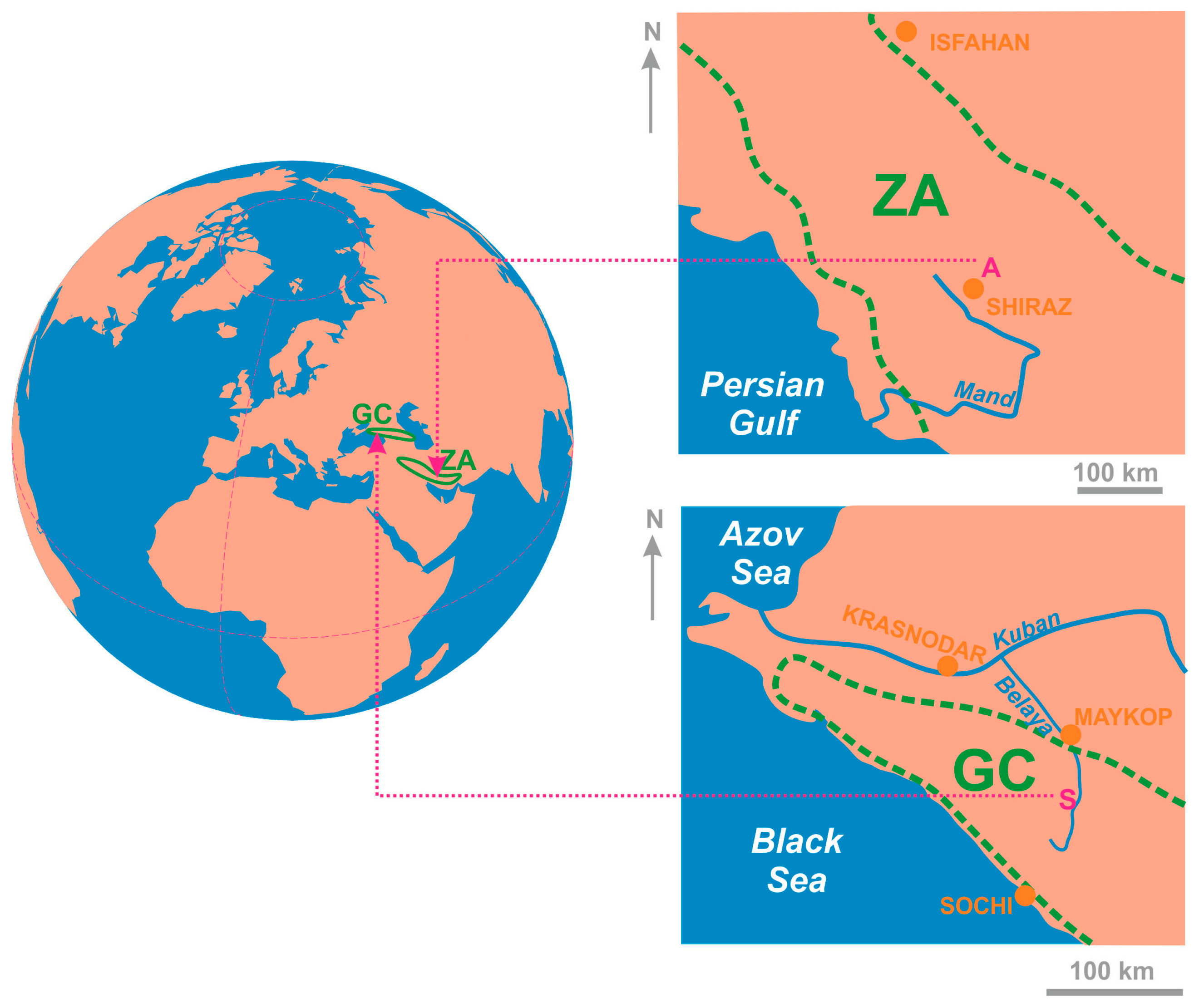
Figure 1. General location of the considered geological domains (outlined by green lines). Abbreviations: ZA—Zagros, GC—Greater Caucasus, A—Abmorghan anticline, S—Skala monocline.
Heritage 06 00315 g001
Figure 2. Geological setting of the Abmorghan anticline. The geological map is adapted from Andadlibi [52]. Figure 1 and the geographical coordinates indicate the location of this plot.
Heritage 06 00315 g002
Figure 3. Geological setting of the Skala monocline. Figure 1 and the geographical coordinates indicate the location of this plot.
Heritage 06 00315 g003
Figure 4. Panoramic and close-up views of the Abmorghan anticline: (a,b)—contacts of the Sachun, Jahrum, Asmari, and Razak formations, (c)—dolomitic limestones of the Jahrum Formation, (df)—karst features from the Jahrum Formation, (g)—stromatolite (with inserted microphotograph), (h,i)—intraformational conglomerates (with inserted microphotograph; 1—bivalve shells, 2—foraminifera tests, 3—chert clasts).
Heritage 06 00315 g004
Figure 5. Features from the studied locality of the Skala monocline: (a)—carbonates of the Gerpegemskaya Formation, (b)—variegated siltstones with carbonate and marlstone interbeds of the Mezmayskaya Formation, (c)—panoramic view from the cuesta edge toward the inverted landform (Gud) and the Late Triassic reef (Big Tkhach).
Heritage 06 00315 g005
Table 1. Tentative criteria for judgments of the geoeducational potential employed in the present study.
CriteriaGradesScores
Number of teaching topics>2 topics7
2 topics5
1 topic3
Teaching opportunitiesLearning, practicing, challenging7
Learning, practicing/challenging5
Learning3
Remoteness from the nearest universities or their permanent field camps/stations<1 h (chiefly hiking for small distance)3
1-day excursion (chiefly cars, excursion buses, boats)2
>1 day of travel (complex transport solutions and need for hotel/temporary camp accommodation)1
Connectivity by public transport
(stops of buses, trains, ships)
Present3
Absent0
On-site accommodationPlace for large buses (or ships)3
Place for cars and small buses (or boats)2
Place for only visitors1
Size of group (students and professors)>25 persons3
5–25 persons2
<5 persons1
Dependence on weather conditionsAbsent (weather conditions do not matter)3
Weak (bad weather conditions are rare)
Moderate (bad weather conditions are rare in some season(s), but common in other season(s))2
Strong (bad weather conditions are rather common in some season(s), but very common in other season(s))1
Very strong (bad weather conditions are common)0
Additional on-site features of interest (geological and geomorphological, other natural, cultural and historical) Present1
Absent0
Geoeducational potentialTotal scores
Advanced>23
Moderate17–23
Basic<17
Table 2. Geoeducational potential of the two considered localities.
CriteriaAbmorghan AnticlineSkala Monocline
Number of teaching topics75
Teaching opportunities77
Remoteness from the nearest universities or their permanent field camps/stations22
Connectivity by public transport
(stops of buses, trains, ships)
00
On-site accommodation33
Size of group (students and professors)32
Dependence on weather conditions21
Additional on-site features of interest (geological and geomorphological, other natural, cultural and historical)11
Total scores25
(advanced potential)
21
(moderate potential)
Disclaimer/Publisher’s Note: The statements, opinions and data contained in all publications are solely those of the individual author(s) and contributor(s) and not of MDPI and/or the editor(s). MDPI and/or the editor(s) disclaim responsibility for any injury to people or property resulting from any ideas, methods, instructions or products referred to in the content.