

Fire, Volume 4, Issue 1 (March 2021) – 14 articles
Cover Story (view full-size image):
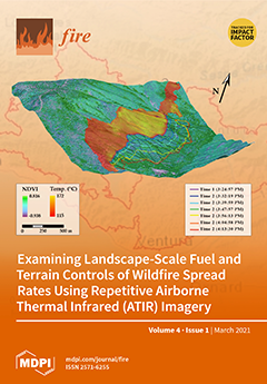
Wildfire rate of spread (ROS) is critically important to fire scientists and managers. However, most studies investigating the controls of fire spread are limited to laboratory and outdoor fire experiments, or to the analysis of coarse-scale satellite images of natural events. Repetitive airborne thermal infrared imagery collected during the 2017 Detwiler and Thomas wildfires in California enabled the landscape-level delineation of active fire front locations and ROS measurements. The cover graphic is a 3D rendering of a portion of the Detwiler Fire. Sequential fire front locations are delineated on a pre-fire normalized difference vegetation index image “draped” over a terrain model. Active fire temperatures for the first image pass are indicated behind the first fire front. The article (p. 9–15) reports the results of statistical analyses on topographic and fuel controls on ROS. View this paper
- Issues are regarded as officially published after their release is announced to the table of contents alert mailing list.
- You may sign up for e-mail alerts to receive table of contents of newly released issues.
- PDF is the official format for papers published in both, html and pdf forms. To view the papers in pdf format, click on the "PDF Full-text" link, and use the free Adobe Reader to open them.
Previous Issue
Next Issue